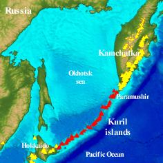
KURILES ARC
The Kurile chain belongs to the system of islands arcs that borders the continents of Asia on the East ; it extends from the South of Kamchatka to the islands of Hokkaido (Japan) separating the marginal Sea of Okhotsk from the Pacific Ocean. The islands of the Kuril Arc are divided into two chains, the Lesser Kurtils and the Greater Kurils. The non-volcanic Lesser Kuril chain extends North-eastward of Kokkaido for 1054 km and then becomes the submarine Vitiaz Ridge ; its islands are composed of volcanic and sedimentary rocks of upper Cretaceous age. The Greater Kuril chain is volcanic and extends for 1150 km ; its basement is composed of tertiary volcanic-sedimentary rocks. According to details of the topography and petrochemistry, it is possible to separate a main volcanic zone, with most of the islands and sub-aerial volcanoes, from a western zone, with seven small islands and most of the submarine volcanoes. In the Kuriles there are at least 85 separate Quaternary volcanoes and volcanic groups, of which sixty have erupted during the Holocene and thirty- seven since the eighteenth century. There are more than 100 undersea volcanoes, but few submarine eruptions are known..
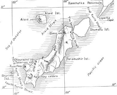
Paramushir islands
The island of Paramushir is the largest of the North Kurile islands and the second in area, after Iturup, in the whole Kuril chain. The island is elongated in the direction of trend of the arc, with a length of about 100 km and an average width of 20 km. The total area of the island is 2042 km. The island is composed of Neogene, dominantly sedimentary-volcanogenic rocks, which are thrown into gentle folds usually trending parallel to the trend of the arc. A fauna of middle Miocene to Pliocene age is found here. The underlying unfossiliferous series is presumably lower Miocene and Upper Paleogene. Some outcrops of granitoïd intrusions are of presumably middle Miocene age. Quaternary volcanic rocks and modern volcanoes are concentrated in the Northern and Southern parts of the island, forming the northern part of Vernadskii and Karpinsky Ridges. On Paramushir, as on the other large islands of the Kurile chain (Urup and Iturup), an important role is played by eruptions similar to the fissure type ; on Paramushir these eruptions played a dominant role. Of all the volcanoes on this island, only two are structures of the central type (Fersman and Fuss Peak volcanoes. Paramushir island and its volcanoes below
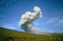
Ebeko volcano
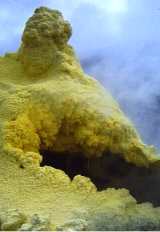
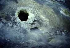
Ebeko volcano is a cone 200-220 m high (absolute height, 1037 m) ; it is strongly elongate in an East-West direction, with three adjoining craters at the summit that stretch like a chain from north to south. The dimensions of all three craters are approximately the same : the rim diameters are about 300-350 m, the floor diameters about 200 m. The aggragate dimensions of the summit craters are 350 x 800 m. On the eastern and western sides there are two open amphitheaters that probably are lateral explosion craters, strongly broken down by subsequent erosion ; a similar crater of smaller size and containing a small lake lies at the north slope. A strong group of solfataras that are depositing sulfur occurs in the eastern part of the southern summit craters and in particularly on the outer slopes of the cone and on the floors of the lateral explosion craters. Temperature of the solfataric gases near their vents was about 98°-100°C ( SVE ; 1993) Steep sulfur cones or hollow pipes are usually formed at the solfatara vents ; gases escaped under great pressure from their tops, and molten sulfur boiled within them. The outer parts of the sulfur " pipes " consisted of common, brigh yellow, rhombic sulfur ; the inner part of the pipes in the higher temperature solfataras has an orange color and apparently consisted of the monoclinic form. Carbon dioxide (up to 92% of the gas other than water vapor) predominated in the make-up of the fumaroles gases, H2S, SO2 and Hcl were present in large amounts. Numerous flows of blocky lava run down to the west from the foot of Ebeko cone. These flows have completely flooded the cirque and upper U-shaped valley of Gorshkov River, extending 3.5 km of the cone. Ebeko lavas have the composition of pyroxene andesit-basalt or, more rarely andesite. Ebeko is the only active volcano on Vernadskii Ridge. Latest eruption of the volcano occured in 1991.
|
Ebeko
- eruptive activity (1989-91) - IVGG
|
|
Ebeko
sulfur cone (H.Gaudru)
|
|
Ebeko
solfatare (H.Gaudru)
|
Chikurachki
Chikurachki is a stratovolcano of 1817 m (5960 ft. elevation). From the North it appears to be a regular cone with a large crater 450 m (1479 ft) in diameter and 250 m (820 ft) deep. In absolute height Chikurachki is the highest volcano on Paramushir and the third highest in the Kuriles. In the lower part of the eastern slope the outlines of numerous lava flows show through from beneath the sheet of scoria. There are also many lava flows along the northwest slope downward to the sea, where about 5 km from the summit, they form capes Chikurachki and Svirepyi.Chikurachki has had eight documentated eruptions since its largest historical eruption in December 1853, when 1km3 of tephra was ejected. Latest recent eruption occured in January-February 2002.
|
Chikurachki
volcano from the North ( H.Gaudru)
|
Tatarinov
Tatarinov is an active stratovolcano, 1530 m (5020 m) height. It is a part of the Karpinsky Ridge, merging in the north with Chikurachki volcano and in the south with Lomonossov cone. It forms an irregular mass, complicated by several summits and lateral craters. On the tops there are 3 craters with some fumaroles. Several very active solfatara fields occupy the east slope at an elevation of about 1000 m (3280 ft), and many old lava flows cover the northwest flank. In contrast to the frequently active Chikurachki, the Tatarinov group is extensively modified by erosion. Tephrochronology gives evidences of only one eruption in historical time from Tatarinov (17th century), although its southern cone contains a sulfur-encrusted crater with fumaroles that were active along the margin of a crater late until 1959.
|
Tatarinov
volcano - aerial view - (H.Gaudru)
|
Fuss peak
Fuss peak is a unique, isolated stratovolcano that forms a distinct peninsula near the southwest coast of the Paramushir island. The peak is a truncated cone 1772 m (5800 ft) in elevation and 9 km in diameter. The active crater, about 700 m (2300 ft) in diameter and 300 m (984 ft) deep is open to the northwest. Several lava flows are visible on the upper part of the volcano and pyroclastic materials are recovered from the lowest part. The only important activity was registered in 1854. Some small fumaroles rises in the eastern part of the summit crater.
|
Chikurachki
(left) and Fuss peak (right) -H.Gaudru
|
Karpinsky caldera
Karpinsky caldera closes the Karpinsky Ridge in the south, and merges in the north with an old ruined volcanic rock, Beloussov mountain. The volcano is a sloping cone with a base diameter of about 15 km. On the top of the cone is a vast caldera, about 5 km in diameter, open to the northwest, with many eruption centers. The bottom of the caldera, 700 m (2300 ft) deep, is gently inclined to the northwest, with an exit to the Okhotsk Sea. The external slopes on the east and south are cut by deep valleys.The last, small eruptive activity was noted in 1952.
.jpg)
|
Karpinsky
cone -South Paramushir) - IVGG
|
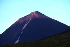
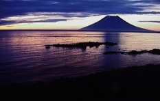
Alaid volcano
Alaid volcano is a beautiful regular truncated cone that forms the isolated island of Alaid (northwest Paramushir), the highest volcano of the Kuriles islands. It rise at 2339 m (7674 ft) above sea level and more than 3000 m (9840 ft) above the sea bottom. Its diameter is about 15 km. But if Alaid gladdens the eye with the perfection of its form and the ideal preservation of its slopes, as seen from the north, it presents a different picture from the south.Indeed, the rim of a old crater and the upper slopes of the volcano are in ruins. The summit crater appears like a wide and deep depression opened to the south, extending from the top to the south-southwest lower flanks. The upper part of the somma slope is covered with scoria and has praticcally no erosion gorges. Several adventive cones are in the eastern sector of the base of the volcano. On november 13, 1933, a flank eruption created a new lateral crater named Taketomi. A strombolian type eruption emitted cinders and rocks until May 1934. Such eruptions, frequent on this volcano, occured in 1790-93, 1854, 1860, 1894, 1933-34, 1981 and between 1982 and 1986. During SVE observation in August 1993 a small fumarolic activity was visible from the top of the volcano.
|
Alaid
volcano island at the sunset (H.Gaudru)
|
After the Kuriles trip, the SVE team, led by Henry Gaudru met the russian scientists at the Institute of Volcanic Geology and Geochemistry in Petropavlosk (Kamchatka) to present a preliminary observation report (August 1993)
More about Kuriles islands and Russia : Ikip - Ishizuka - EMSD - AVO-KVERT