Mount
Cameroon eruption - SVE report
April
1999
 |
Between march 28 and 16 april 1999, Mt. Cameroon went to a new eruption. With an elliptic shape (35x40 km), Mt. Cameroon culminates at the Fako summit of altitude 4095 m Mt. Cameroon is the only volcano no outside the Mediterranean sea to have a documented eruption before the time of Christ (e.g. Hannon from Carthagens at the fourth century B.C.). During the twentieth century, it erupted in 1909, 1924, 1954, 1959, 1982.Its historical activity has consisted of moderate explosive and effusive eruption from both summit and flank vents. Numerous small cinder cones dot the flanks and surrounding lowlands. After 17 years of dormancy, the volcano wake up on the 28th March 1999. |
GEOLOGICAL FRAMEWORK OF MT. CAMEROON:
The Cameroon Volcanic Line (CVL) to which belongs Mt. Cameroon is a major structure in Africa. With an extension of more than 1600 kms and trending N30°E, the CVL is formed of an alignment of volcanoes divided into tho segments: an oceanic segment (St. Helens, Pagalu, Sao Tome, Principe, Bioko) and a continental segment (Mts. Cameroon, Manengouba, Oku, etc.). The line is though to originate from various geologic processes such as: epeirogenic movements following the disruption of Gondwana, hot spot, rift in construction, etc. Out of Mt. Cameroon, major historical naturel phenomenon recorded along the live had been the release of toxic gas in lakes Monoun and Nyos that, respectively in 1984 and 1986 killed 37 and 1746 people.
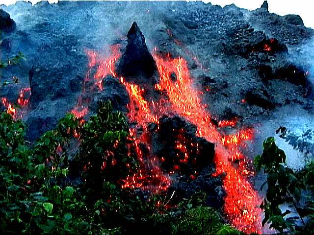
THE ERUPTION : On March 28, 1999, Mount Cameroon went into eruption following a series of widely felt earth tremors. This marked the sixth eruption within this century. Two erupting sites have been identified. The first, which entered into activity on March 28, is located on the Southern flank of the mountain along a fissure trending NE-SW at an altitude of 2650 m and were marked by explosive magmatic activity that sent scoriaceous bombs to 500m laterally from the vents and short a'a flows less than 3 km in length. The second site which appeared two days after was located along the same trend but much downslope and closer to the west coast village of Bakingili. This site was at an altitude of about 1400 m. Eruptive activity, was characterized by important lava flows emission from the lower fissure towards the West cost. Lava flow was constitued of basaltic blocks varying between 5 and 20 meters of thickness, 500 to 800meters of extension. The speed was also varying, depending on the topography, between 4 and 24 meters per hour The flow travelled on 14 kilometers and stopped only at 200 meters of the atlantic ocean and interrupted the costal road between Batoke and Bakingili. The basaltic products emitted are of grey to blact colour, microlitic porphyrictic in texture and a vacuolar structure. porphyritic crysts are those of olivine and pyroxene, whilst matrix is rich in plagioclases and pyroxenes The last glow from the 1,400 m vent was seen on 14 April, and lava production probably ended about this time.
Field Observations : A french team visited the volcano between April 9 and 17, 1999. The upper (altitude 2650 m) fissure, opened March 28, was observed April 13 and 14. Eight small cones (5 m to 60 m high) were aligned N 40 - N 45. April 13 evening (17 h 30 - 19 h 30), four cones were active, three of them emitting white vapor. The last one, situated in the northern part of the fissure, showed a strong degassing activity, from two vents, roaring like a jet engine. At te beginning of the night, a red glowing was visible above this cone. Each several minutes, some incandescent bombs were ejected until 200 m high, probably as a consequence of the strong degassing. April 14 morning (9 h - 12 h am), the activity was rather the same, except for the last northern cone. This produced two important grey turbulent columns, observed until 10 am. After, between 10 and 12 am, the activity was the same than those of April 13. Abundant sublimate were observed around each vent, as well as on the major part of one southern cone. During these two days, no magmatic activity has been noticed. The lava field, resulting of the three first days of eruption, about 3 km long, was. still hot. Between April 9 and 17, the lava front, issued from the lava flow of the lower (altitude 1400 m) fissure, opened March 30, was regularly observed. This front consisted of collapsing hot blocks, which were fragmented during their falls, revealing red lava. The front was several 100 m wide and about 10 m thick, progressing at several meters per hour. April 10 morning, the front was at 120 m above sea level, 600 m from the road near Atlantic coast, between Limbe and Idenau and more precisely between Batoke and Bakingili. April 10 evening, the velocity of the front had slightly increased as the lava flow entered a small valley. April 11 evening, the front, 150-200 m wide and 20 m thick, had progressed of about 30 m since the preceding day. Huge blocks, 3-4 m in size, were collapsing. April 13, according to Cameroon volcanologists, the front was only 260 m from the road. April 14 evening, the front, 20 m thick, had reached its maximum activity. It was completely incandescent, progressing at 7-15 meters per hour and was situated at only 100 m of the road. April 15 morning, lava front was at 5 m of the road. During the whole day, the front did not progress significantly but three other lava lobes were developped in lateral positions. April 15, at 19 h, the first incandescent block had fallen on the road. During the night of April 15-16, the road was closed. April 16, during an helicopter flight with the Cameroon volcanological team, we could observed the road recovered on a distance of 100 m under 10 m thick lava flow. April 17 the front had not evolved significantly and seemed more or less stabilizated. The last glow from the 1,400 m vent was seen on 14 April, and lava production probably ended about this time. From Cameroon observers, occasional small earthquakes and posible minor volcanic tremor persisted until 22 April. A new road has been built along the distal end of the flow to restore normal traffic along the coastal road.
DAMAGES AND SOCIAL EFFECTS OF THE ERUPTION Earth tremor that preceeded and accompanied this eruption have been felt-up to Douala, Kumba and Nkongsamba. The most serious shock occured on March 28, 1999 which measured between IV-V on the Mercalli Intensity Scale. ( magnitude about 3..2) Analysis of the felt intensities placed the epicenter closest Buea Town. Effects of these tremors have ranged from panic, peple rushing out of houses, people evacuating the town overnight, simple fractures on structures and complete collapse of walls. Other manifestation of the tremors included surface fracturation and landslide. There has also been an effect of seismic events on water, in particurlarly at the Mutengene source where the water became abnormally muddy.Explosive activity from the first site ejected volcanic bombs, blocks, lapilli and ashes. These ashes, transported in the direction of the prevailing winds have been felt on Bakingili, Batoke, Debundsha and Idenau. Ashes effects have been reported by affected people (irritation of the skin and the eyes. This eruption and their associated events have had adverse effects on the environment as well as the local economy. Forest ecosystems ( about 1000 hectares have been consumed), plantations and man-made structures have been destroyed, in particurlarly many private houses. It is clear that the most affected houses had been constructed with disregard to appropriate building codes and along seismogenic zones. ( first estimated cost reach more than 420 millions of CFA francs . Many people have been affected by disaster and/or evacuated (more than 1000 people) but, no human life has been lost. The coastal road which was interrupted with the lava flow. A new road has been built along the distal end of the flow to restore normal traffic along the coastal road. As of early May about 400 evacuees from Bakingili were still being housed in a nearby refugee camp, but were expected to be allowed to return to their homes shortly.
NECCESSITY OF AN EARLY WARNING SYSTEM FOR MT. CAMEROON: Mt. Cameroon is located within a very fertile and densely populated area. In addition to the city of Buea just on the side of the mountain, the coastal side of the mountain shows a ring a cities totalizing with more than 75000 inhabitants. At 50 Km is the biggest city of Cameroon, Douala with 2.5 millions inhabitants; tremors are reported to have been feeled there. That situation very close to populations renders of the greatest importance the building up of an early warning system for the detection of premonitory signs of future eruptions. During the days preceeding directly the eruption, seisms were recorded by the geophysical station of the geological survey of Cameroon, located in the town of Ekona at the north eastern side of the mount. Out of six seismographs, only one was working at the time; rendering impossible a scientific link between the observations and possible future volcanic eruption. Another potential danger at Mt. Cameroon is the possible occurence of lahars. Heavy flows of non historic lahars form the substratum of a part of the city of Buea, and of the totality of the city of Mutengene , also on the flank of Mt. Cameroon. Most of the houses destroyed during the current eruption were built on these formations. With the conjunction with the great yearly amounts of rain in the area (10 meters) the occurence of lahars is not impossible, as well as a remobilisation of the present lahars formations. Even if historical eruptions of Mt. Cameroon did not cause losse in human lives, it is important to note that the risk exist. The building up of a warning system for the entire mount seems to us of the greatest importance.
RESPONSE OF LOCAL INHABITANTS : No volcanic early warning system can be helpful without the collaboration of local populations before and during the eruptions. In spite of the fact a part of local people had also lived the 1982 eruption, we noticed that local populations continue to see in eruptions of Mt. Cameroon, not a natural phenomenon that could be predicted, but as manifestations of ancestral sanctions. A better education of local people in their attitude in front of forthcoming volcanic manifestations is also a great challenge to geoscientists, and seems to us as important as putting in place heavy investments for an efficient early warning system.
CONCLUSION : The 1999 eruption of Mt. Cameroon has, on the volcanological point of view, no significative change comparatively to previous eruptions. Damages seemed to gain more importance has during previous eruption, looking at the rapid urbanization and a rapid development of touristic structures of the coastal side of the mountain.
Henry Gaudru, European Volcanological Society ( S.V.E.) C.P.1 - 1211 Geneva 17 - Switzerland - Fax : 41.22.759.21.05 - Email : HGaudru@sveurop.org, Jean-Pierre Tchankoue, Dept of Earth Sciences, P.O. Box 812, Yaounde - Cameroon - Fax : 237-221873 - Email : Tchouankoue@uycdc.uninet.cm, J.M. Bardintzefft, University of Paris-Sud , Lab of Petrology, Orsay, France, Email :bardintzef@geol.u-psud.fr