SVE MISSION - VOLCANOES OF VANUATU - July 1996
TECTONIC and GEOLOGY
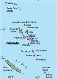
Vanuatu archipelago is a Y -shaped chain of Pacific islands, extending about 1200 km (720 mi) in the North-South direction between the Equator and the Tropic of Capricorn. The total area of Vanuatu is about 860,000 sq.km (of which only 12,336 sq.km is land). This comprises 80 islands, but only 12 can be called significant in terms of economy and population. The archipelago is on the edge of the Pacific tectonic plate which is being forced up and over Indo-Australian Plate. This enormous and relentless pressure causes constant seismic activity in the form of earthquakes and volcanic eruptions. The volcanoes of Vanuatu have a number of particular features :- a) They produce a great deal of basalt with varying amounts of volatile elements and potassium, rubidium, barium, lanthanium, etc... b) The earth's crust in this zone is thick and a large quantity of magma can be trapped at shallow depths. c) The site is particularly likely to produce violent water-magma interaction with accompanying cataclysmic events. - Local oral traditions report that the islands of Epi and Tongoa were once part of the land Kuwai, which broke up in a volcanic cataclysm in the fifteen century.Volcanic arc of Vanuatu has 7 major active sub-aerial-volcanoes : Yasur, Ambrym, Aoba Lopevi, Gaua, Suretamatai, Tinakula-and several submarine volcanoes. SVE team visited four volcanoes :
YASUR
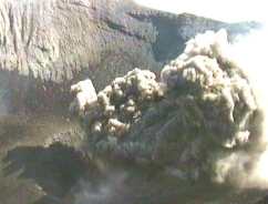
Yasur is the most known of Vanuatu volcanoes, the only active volcano on Tanna island. It is a small pyroclastic cone contained within the small Yendahe caldera with readily accessible craters. It has been reported as continually active (strombolian-vulcanian explosions) since before 1774 when the volcano was observed by Captain Cook. Numerous small or mild explosions hurl lava bombs 20 to 300 meters (66-985 ft) in the air The gas plume discharged from the volcano is carried by the prevailing SE~ trade wind across the centra] part of the island. It is presently not a very dangerous volcano, even if, from time to time, it is more active and destroys some vegetation around It by acid rains resulting of its sulfurous emanations. However, the entire Siwi area, very prone to strong seismic activity and ground motions and where a great caldera formed a few tens of thousand of years ago, should be considered as a hazardous zone.
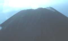
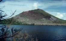
AMBRYM
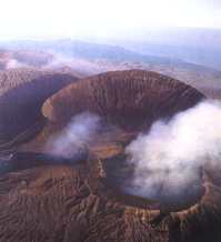
Ambrym is one of three more active volcano and the most fascinating also with its large caldera, quite atypical for a mainly basaltic edifice It is also the most voluminous active volcano in the Vanuatu, a 35x50 km-wide (21x30 mi) basaltic volcano about 1800 m (5900 ft) high relative to the nearby sea bottom The main cone is crowned by a circular, 12 km (7 mi ) -diameter caldera with a continuous scarp a few tens of meters to 450 m (1476 ft) high. Post caldera volcanics, dominantly from the Marum and the Benbow intra-caldera cones have partly filled the depression. During the two last centuries, it had at least eight large eruptions, with extra-caldera flows, and sometimes destructive eruptions as in 1894, 1913, or 1929, one can note that during the last fifty years, no extra-caldera flows eruption has been reported. The last important eruption was in 1988. There is an almost permanent lava lake activity from both Benbow and Marum craters. In period of normal activity, the impact of the volcano is restricted to the caldera and to the downwind flank and ininhabited coast located between Craig Cove and Ranon. Direct ashfalls from a large eruption threaten all the island of Ambrym except, perhaps the northern extremity. Lava flows and lahars related to a large eruption threaten both : the low costal areas at the mouth of streams and rivers, which might be affected by lava flows as well as by lahars ; the West and East fissure zones, which already emitted the majority of the lateral flows and specially the western and eastern extremities of the island where the activity seems to concentrate at the end of major eruption (1888, 1913,1929).
LOPEVI
Lopevi is one of the three most active volcanoes of this archipelago. almost constantly active, sometimes quite strongly as in 1960. Lopevi has a elliptical base 55 km to 75 km ( 33 to 45 mi) across and rises to a classic cone over 1413 meters (4636 ft) high Since the first report of activity in 1863, this strato-volcano has been almost continuously active, with frequent ash emissions, pyroclastics flows, and lava flows A very" powerful eruption occurred in 1970. Everyone was hurriedly evacuated and resettled on Epi Island. All flanks of the volcano are at high-risk. Moreaver, Lopevi may give ash falls up to Paama, as in 1963, which can bother the inhabitants but do not represent a major threat. Recent activity occured throught year 1999
GAUA
Gaua is a composite volcano with a large ( 8x6 km) ( 2.4x1.6 mi) central caldera. Mt. Garet sitting in this caldera occupied by the Iake Letas, is a very active volcano. Its situation, and the presence of lake Letas indicated that any magma rising presents a serious risk water-magma interaction which could lead to a highly exp!osive eruption. At one side of the volcano a massive waterfall powers down into misty jungle. Only solfataric activity was recorded from 1868 to 1962 Beginning in 1962, central crater expIosions with frequent associated ash columns were reported nearly every year until 1977. Due to the situation of active Mount Garet at the center of the lake, explosive magma water interaction might occur during a magma rising phase.
A PROGRAM FOR REDUCTION OF VOLCANIC HAZARDS
At the beginning of the International Decade for Reduction of Natural Disasters ( IDNDR), in 1990, Orstom ( now IRD) started the program " study and surveillance of volcanoes of Vanuatu". The first stage was a geological study of historical events. The results obtained allowed the creation of volcanic hazard maps for the four most active volcanoes of the archipelago.The second stage concerned the seeting in place of a "minimal" surveillance tools on three volcanoes. The tranfer of skills and knowledge was also a part the objectives. As a reult of the volcanic crisis (Ambae, 1995) , we started a program to educate the most affected populations and to develop co-operation with the National Disasters Management Office of Vanuatu. The last stage of the program consisted of estimating the impact of natural disasters on the economy of the country.
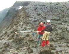
Tools are simple and reliable surveillance systems, suited to Vanuatu resources, which were set in place in 1992. Seismic activity is recorded continuisly from the four volcanoes equipped with monitoring stations; data is transmitted by satellite system (Argos) and is available via the Wild World Web. Permanent or cyclic geophysic and geochemical measurements complement this activity.
********************************************************************
Informations-contact : H.Gaudru - SVE Geneva
SVE team : H. Gaudru, C.Pittet, G.Borel, C.Bopp - IRD contact : M. Lardy - IRD France
Ref : Volcanic hazards in Vanuatu, C. Robin, M. Monzier, IRD document N° 16, 1995 -