VOLCANO
NEWS
Updated on 24th of October 2025 (latest news classified according to countries)
Highlight today :- New explosive activity occurred at Mayon volcano (Phillipines)- Small phreatic eruption occurred at Poas volcano (Costa Rica) - Scientific report about Santorini crisis (Greece)
Episode 35 ended at Kilauea volcano (Hawaii - USA)
Saint Vincent - Soufriere volcano (West-Indies)
October 9th, 2024
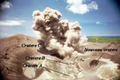
As of the 8th of October 2024, according to the Seismic Research Centre, a low thermal anomaly, indicating temperatures above normal levels, was detected at the summit of the volcano by NASA's FIRMS hot spot detection system on 6 October. The heat anomaly is currently ongoing. Potential explanations for this detection include a sulfur fire in the crater, a small phreatic (steam) eruption that may have exposed hot rocks, or the beginning of new lava extrusion within the crater. The National Emergency Management Organisation's (NEMO) Soufrière Monitoring Team is currently analyzing multigas data collected on 4 October, with further investigations, including a sea-based reconnaissance along the West Coast, still underway. Additional updates will follow once the analysis of this data and visual observations are complete. Despite the anomaly, the volcano's status remains at the Green, meaning it is quiet, and both seismic and fumarolic (steam vent) activities are within normal historical levels. No other unusual activity has been observed. Previous news 2022 - As of the 17th of March 2022, seismic activity at La Soufrière, St Vincent has continued to decrease reaching the minimum activity since the tremor associated with the explosion and ash venting on 22 April, 2021. No lahar signals have been recorded. As of the 15th of February, UWI-SRC reported that seismic activity at La Soufrière, St Vincent has continued to be at a low level since the tremor associated with the explosion and ash venting on 22 April. No lahar signals have been recorded. Gas measurements indicate that the plume chemistry shows decreasing sulphur dioxide (SO2) and carbon dioxide (CO2) concentrations. The plume chemistry indicates that the gas composition is slowly returning to its pre- eruption chemistry. Previous news 2021 - As of the 30th of November, UWI-SRC declared Eruptive Phase Ends at La Soufriѐre Volcano. Activity at the volcano has declined steadily since the last explosive event on April 22nd, 2021and all currently available monitoring data points to an end in eruptive activity. However, residual steaming at the summit and lahars (mudslides) in the valleys surrounding the volcano will continue to be observed for some time. As of the 24th of November,UWI-SRC reported that the seismic activity at La Soufrière in St Vincent has continued to decrease since the tremor associated with the explosion and the evacuation of ashes on April 22. Small lahars were recorded on October 31. Current activity corresponds to a period of unrest after an eruption. As of the 22nd of October, UWI-SRC reported that seismic activity at La Soufrière, St Vincent has continued to decrease since the tremor associated with the explosion and ash venting on 22 April. No lahars occurred . Previously, one lahar was recorded on 11 Oct. UWI-SRC reported no change have occurred in the crater. Measurements of the sulphur dioxide (SO2) flux at La Soufrière were carried out by boat off the west coast on 23rd September. Several traverses were completed and yielded an average SO2 flux of 176 tons per day. Three lahar signals were observed between 26 - 27 September..Visual observation on 19 of September indicated no major major change have occuured in the crater. As of the 16th of September; the alert level of the volcano La Soufrière de St. Vincent has been lowered to YELLOW. A Yellow alert level means that the volcano is agitated, that the seismic or fumarolic activity is higher than the historical level of the volcano. Activities on the volcano have been weak and significantly reduced in recent months since the last explosive eruption on April 22, 2021. All the communities that evacuated following the evacuation order given on April 8, 2021 can now return to their homes. Access to the top of the volcano remains restricted.As of the 14th of September, UWI-SRC reported that Seismic activity at La Soufrière, St Vincent has remained low since the tremor associated with the explosion and ash venting on 22 April.No lahar signals have been observed and work has been completed on all seismic stations As of the 30th of August, UWI-SRC reported that over the past week, there has been a slight increase in magnitude, but this has provided no indication of reactivation. Current activity corresponds to a period of unrest after a rash. This can last for weeks or even months. While volcanic activity is on the decline, there is the continued presence of hot spots near the surface, daily seismic activity, and persistent outgassing. Lahar signals were observed: 4 on August 24, and 1 on August 25, related to the precipitation that was recorded during this period. Clear weather conditions at the volcano on August 30 allowed excellent views of the crater and observations indicate that no major changes have occurred in the crater since the end of explosive activity on April 22. As of the 28th of August, UWI-SRC reported that current activity corresponds to a period of unrest after an eruption. This can last for weeks or even months. Heavy rains over the past week-end resulted n lahars in most of the valleys on the volcano. These were all flows very similar in characteristics to a swollen river. On Aug 15, vigorous steaming accompanied a period of heavy rainfall. These observations are in keeping with the continuedpresence of near surface hot spots within the crater and are not a sign of an explosive eruption occurring. Measurements of the sulphur dioxide (SO2) flux at La Soufrière were carried out by boat off the West coast on 10 August, with the assistance of the coast guard. Several traverses were completed and yielded an average SO2 flux of 205 tons per day. While volcanic activity is on the decline, there is the continued presence of hot spots near the surface, daily seismic activity, and persistent outgassing. Sulfur dioxide flow measurements at La Soufrière were taken by boat off the west coast on August 3, with help from the coast guard. Several crossings were made and gave an average SO2 flow of 207 tonnes per day.As of the 5th of August, UWI-SRC reported that In the last 24 hours, only a few small earthquakes have been recorded. Persistent steam emissions from a few regions inside the crater. Measurements of the sulphur dioxide flux at La Soufrière were carried out by boat off the west coast on 22 July, with the assistance of the coast guard. Several traverses were completed and yielded an average SO2 flux of 233 tons per day. Recent mapping confirmed that no new lava dome formed as a result of the explosions that ended on the 22 April 2021, and the average characteristics inside the new crater (including the crater itself) are all the result of the explosive phase of the eruption between April 9 and 22, 2021. Mapping has identified several prominent fumaroles that are the source of the vapor and gas plumes visible above the rim of the summit crater on a clear day. The presence of fumaroles also confirms the detection of thermal anomalies inside the new crater by the satellites. As of the 6th of July UWI-SRC reported that seismic activity at La Soufrière, St Vincent has remained low. In the last 24 hours, only a few small earthquakes have been recorded. Persistent steam emissions from a few regions inside the crater continue to be the dominant observable feature. Measurement of the sulphur dioxide (SO2) flux was carried out by helicopter on June 23rd and yielded an average SO2 flux of 683 tons per day. SO2 can be an indicator that fresh magma from a deeper source is being degassed. As of the 18th of June, UWU-SRC reported that persistent steam emissions from a few regions inside the crater continue to be the dominant observable feature. As o the 15th oj June seismic activity at La Soufrière, St Vincent has remained low since the tremor associated with the explosion and ash venting on 22 April and in the last 24 hours, only a few small earthquakes have been recorded.Thermal anomalies continue to be detected but do not indicate an explosive event is imminent. As of the 12th of June a photo taken by Prof. Robsertson shows now look of the Crater with 1979 crater rim, the 2021 new explosion crater rim, and the lake. There are several hydrothermal vents and these are responsible for the vapor that can be seen on most days. The alert is still in Orange and access to the volcano is still prohibited for the moment. UWI-SRC noted that with the start of the rainy season, the main danger at Soufrière de St Vincent remains the risk of lahars. Several lahars were reported between 5th to 7th of June.No change reported during the last 24 h regarding previous news. As of the 3rd of June, UWI-SRC reported that in the last 24 hours, only a few long-period.earthquakes have been recorded. Persistent steaming is observable from the observatory once the cloud cover is high enough. Thermal anomalies continue to be detected but do not indicate an explosive event isimminent Measurement of the sulphur dioxide (SO2) flux was carried out off the west coast on June 1st and 3rd and yielded an average SO2 flux of 543 and 456 tons per day, respectively. As of the 2nd of June UWI-SRC reported that the volcano is still in a state of unrest and access is prohibited at this time. Seismic activity at La Soufrière, St Vincent has remained low since the tremor associated with the explosion and ash venting on 22 April. From 5:40am on 30 May to 8:00am (local time) on 31 May, there has been no recorded seismicity associated with La Soufrière. Persistent steaming is observable from the observatory once the cloud cover is high enough. Thermal anomalies continue to be detected by the NASA. As of the 28th of May, UWI-SRC reported that a persistent vapor was observable from the observatory once the cloud cover is sufficiently high. Thermal anomalies continue to be detected by the NASA FIRMS alert system. These have persisted since the explosion of April 22. They indicate that there is a heat source in the crater and most likely originate from a small body of magma remaining, near the bottom of Summit Crater. The volcano continues to be in a state of unrest. Escalation of activity can still take place with little or no warning. The volcano is at Orange alert level.As of the 26th of may, UWI-SRC reported that seismic activity at La Soufrière, St Vincent has remained low since the tremor associated with the explosion and ash venting on 22 April. Persistent steaming is observable from the observatory once the cloud cover is high enough. Measurements of the sulphur dioxide (SO2) flux were done on 20 May and yielded an average SO2 flux of 461 tons per day. UWI-SRC reported that on 12th of May, In the last 24 hours, seismic activity was limited to a few long-period earthquakes. Gas measurements on May 11 yielded an average SO2 flux of 252 tons per day. The volcano continues to be in a state of unrest.As of the 10th of May, UWI-SRC reported that in the last 24 hours, only a few long-period earthquakes have been recorded. Measurements of the sulphur dioxide flux at La Soufrière were carried out by boat off the west. coast yesterday (9 May) with the assistance of the coastguard. Several traverses were completed and yielded an average SO2 flux of 208 tons per day. The volcano continues to be in a state of unrest. Escalation in activity can still take place with little or no warning. As of the 7th of may, UWI-SRC reported that seismic activity remained low. No earthquakes have been recorded in the last 24 hours. A small lahar signal was observed at 7:40am on the morning. As of the 6th of May, UWI-SRC reported that the volcano continues to be in a state of turmoil. The government of Saint Vincent and the Grenadines has lowered the volcanic alert level at La Soufrière to ORANGE based on a recommendation from the University of the West Indies Seismic Research Center. As of the 5th of May, UWI-SRC reported that In the last 24 hours, only a few long-period, hybrid and volcano-tectonic earthquakes have been recorded and there was no further seismic tremor. As of the 2nd of May - 6pm - UWI-SRC reported that in the past 24 hours, only a few long-period hybrid and volcano-tectonic earthquakes have been recorded and there have been no further earthquakes. The seismic stations recorded the signals from small lahars around 1 a.m. and 8:30 a.m., in the red and orange areas. The volcano continues to be in a state of unrest. As of the 30th, UWI-SRC reported that activity has remained low. As of the 29th of April, UWI-SRC reported that in the last 24 hours, only a few long-period, hybrid and volcano-tectonic earthquakes have been recorded and there was no further tremor. The seismic stations recorded signals from multiple lahars during a 12-hour period starting at 9pm on 28 April. Lahars seem to have taken place in all the valleys that drain from La Soufrière and caused considerable erosion and damage.As of the 28th of April - 6mp UWI-SRC reported that in the last 24 hours, only a few long-period, hybrid and volcano-tectonic earthquakes have been recorded and there was no further tremor. The volcano continues to be in a state of unrest. As of the 27th - 6pm - UWI-SRC reported that explosions at La Soufriere in St. Vincent have greatly diminished. Seismic activity remained low with only a few long-period hybrid and volcano-tectonic earthquakes recorded and there was no sign of a tremor. Signals of several lahars (mudslides) were recorded between 9 and 10 a.m. on April 27, during and after a period of rain.An observation flight took place on April 26 at around 11:30 am Visibility was poor with clouds blocking the crater most of the time. However it was possible to see white vapor escaping almost continuously from several places on the bottom of the crater. No dome was visible, although a spine could be seen through the cloudsAs of the 25th (6pm) UWI-SRC reported that seismic activity low since the tremor associated with the explosion and ash venting around noon on 22 April.In the last 24 hours, only a few long-period, hybrid and volcano- tectonic earthquakes have been recorded and there was no further tremor. Satellite radar imagery acquired on 24th April indicates probable continued growth or formation of a lava dome following the xplosions on 18 and 22 April. As of the 24th of April UWI-SRC reported that the volcano continues to erupt. Its pattern of seismic activity over the last few days is typical ofthe growth and destruction of lava domes. As of the 23rd of April 6pm, UWI-SRC reported that seismic activity at La Soufrière, St Vincent has been low after the tremor associated with the explosion and ash venting around noon on 22 April. Only a few long-period, hybrid and volcano-tectonic earthquakes were recorded and there was no further tremor.The seismic network recorded signals from multiple lahars (mudflows) at about 9 pm on 22 April. The locations of these lahars have not been only determined.Measurements of sulphur dioxide flux (mass) at La Soufriere volcano was again undertaken along the west coast today with the assistance of the coastguard. An average SO2 flux of 992 tons per day was recorded. As of the 22nd of April, UWI-SRC reported that small long-lived and hybrid earthquakes continued to be recorded, their rate of occurrence gradually increasing on April 22. The high-level seismic tremor began at 11:09 a.m., generated by explosive activity, and lasted for approximately 20 minutes. A vertical explosive eruption plume slowly rose above the crater, eventually reaching a height of around 8,000 meters During the initial stages of the explosion, a base surge (pyroclastic density current, PDC) was observed descending the western flank of the volcano. The tremor continued, at a lower level, for the next two hours as La Soufrière continued to evacuate ash. As of the 21st of April, UWI-SRC reported that seismic activity of the Soufrière of St. Vincent continued the pattern established after the explosive activity of April 18. The agricultural sector of Saint Vincent and the Grenadines has been severely affected by the eruptions of the Soufrière volcano. Preliminary evaluations reveal that in the red zone, 100% of vegetable crops and 60% of arrowroot (dictame) have been lost. The weight of the heavy ash fall caused the leaves and branches of many tree crops to break. About 90% of tree crops and 80% of root crops would also be damaged in the red zone. The cattle, which were left in the wild, are now without fodder as their pastures have also been totally destroyed by ash and dust. Small, long-lived and hybrid earthquakes continued to be recorded, their rate of occurrence gradually increasing over the past 24 hours.As of the 20th of April - 6pm UWI-SRC reported that the volcano continues to erupt. Its pattern of seismic activity over the last few days is typical ofhe growth and destruction of lava domes. easurements yielded an average SO2 flux of 350 tons per day. No seismic tremor has been recorded in the last 12 hours.UWI-SRC reported that swarm of long-lived and hybrid earthquakes continues, with no significant change in their frequency of occurrence. Occasional small volcano-tectonic earthquakes were still recorded. Its pattern of seismic activity over the past few days is typical of the growth and destruction of lava domes. An explosion generated a high level tremor period starting at 4 p.m. 49 April 18. The resulting eruption plume rose over 8 km and drifted south and southwest of the island. An average SO2 flux of 232 and 391 tonnes per day, on April 17 and 18, respectively, was recorded. As of the 17th of April, the swarm of long-period and hybrid earthquakes continued at La Soufrière. The rate of occurrence of these earthquakes dropped significantly at about 8 pm on 16 April and has remained near-constant since. No episodes of tremor have been recorded in the lhe crater is thought to be at least 100 m deep (Raphael Grandin, IPGP) and is centred in the SW sector of theast 12 hours. A revised picture has been constructed of the summit crater based on satellite images. The new crater, measures approximately 900 m N to S and at least 750 m E to W pf the. Summit Crater. As of the 16th of April, UWI-SRC reported that seismic activity at La Soufrière in St. Vincent has changed in appearance and continues with a constant swarm of LP and hybrid earthquakes, interspersed with brief low-level tremor episod. Sulfur dioxide flux measurements at La Soufrière were again undertaken along the west coast, giving an average SO2 flux of 460 tonnes per day. The presence of sulfur dioxide indicates that fresh magma is degassing from a deeper source ... the eruption continues, despite a pause in explosive activity.es. There was a high-level tremor episode at 6:15 a.m., which lasted about three minutes, followed by over two hours of low-level tremor generated by explosive activity and ventilation. SCIENTIFIC UPDATE - 15/04/21 6:00AM - Seismic activity at La Soufrière continued to follow the established pattern with bands of tremor about between 13 and 15 hours apart separated by swarms of small long-period earthquakes. The latest band of tremor started at about 2:30 am and was associated with increased venting. The volcano continues to erupt explosively and has now begun to generate pyroclastic density currents - hot (200°C-700°C), ground-hugging flows of ash and debris. Its current pattern of explosions appears to be episodic (stop-start) with increasing periods between eruptions and less energy. Explosions and accompanying ashfall, of similar or larger magnitude, are likely to continue to occur over the next few days impacting St. Vincent and neighbouring islands.SCIENTIFIC UPDATE - 14/04/21 6:00AM - Seismic activity at La Soufrière, St Vincent showed a similar pattern to yesterday. Small long-period earthquakes continued to gradually increase in number after the explosive activity at 6:30am on 13 April. These continued until another episode of explosive activity started at 8:30 pm on 13 April. This generated continuous seismic tremor which lasted for four to five hours. 5. After the tremor had died down, small, long-period earthquakes were again recorded, again slowly growing in numbers. The explosions which occurred pulsed for >40 minutes and produced pyroclastic density currents (PDCs) which, appear to have gone down valleys that drain towards the Rabacca River on the east coast of the island. PDCs are hot (200°C-700°C), ground-hugging flows of ash and debris. Lahars (mudflows) were reported in the Sandy Bay Area on 13 April. The volcano continues to erupt explosively and has now begun to generate pyroclastic density currents. Its current pattern of explosions appears to be episodic (stop-and-go). Over the past 24 hours the time between each explosion has increased. Explosions and accompanying ashfall, of similar or larger magnitude, are likely to continue to occur over the next few days impacting St. Vincent and neighbouring islands such as Barbados, Grenada, Saint Lucia. The volcano is at alert level Red. UWI-SRC reported that seismic activity changed with the explosive activity at 6.30am on April 13th. Prior to the explosion, long-period (LP) earthquakes had increased in number. The explosions of La Soufrière pulsed for about 30 minutes and produced pyroclastic density currents that reached the sea at the mouth of the Wallibou about 6 km from the volcano and which extended out to sea, according to observers. Observations made during the afternoon show that the pyroclastic flows reached the sea from all the valleys between Larikai and Wallibou. As of the 12th - 6pm - UWI-SRC reported that pattern of seismic activity changed again, with the end of the episodes of high-amplitude tremor 2-8 hours apart.Three episodes of tremor have been recorded since 6am, two of them lower-amplitude and the third, at about 5pm, was high-amplitudeThe episodes continue to coincide with periods of enhanced. A reconnaissance of the entire north coast of St. Vincent from Chateaubelair to Georgetown with assistance from the Coast guards.Observations made indicate that pyroclastic density currents western flanks of the volcano and had reached the sea at Morne onde, Larikai and Trois Loupes Bay.Extensive damage to vegetation was noted in an area extending rom Larikai Bay to Turner Bay on the west coast.No other areas along the coast had been affected by PDCs but villages located on the eastern flank of the volcano had been ffected by heavy ashfall.Explosions and accompanying ashfall, of similar or larger magnitude, are likely to continue to occur over the next few days. UWI-SRC reported that the day of April 12 eruptive activity was marked by a huge explosions at 4:15 am, which was accompanied by a plume of ash and gas reaching an altitude of 17-18 km., And density currents. pyroclastic descending several valleys on the southern and western flanks of the volcano. They reached the sea at Morne Ronde, Larikai and Trois Loupes Bay and caused extensive damage to vegetation. The amplitude of the tremor has changed since April 11 around noon, with a lengthening of the time between high amplitude episodes at 5-8 hours; Around 6 p.m. on April 11, small volcano-tectonic earthquakes were recorded. On April 12, 3 episodes of tremor were recorded for 6 hours, coinciding with periods of explosive activity or increased venting. UWI-SRC - La Soufriere Eruption Scientific Update 11/04/21 at 9am : in the last twelve hours episodes of tremor normally lasting up to 20 minutes have continued to be recorded.The intervals between the tremors have been between 1.5 to 3 hours. Based on visual observations and satellite imagery, the intervals are associated with periods of explosive activity or enhanced venting.Thunder and lightning were experienced during these periods. Heavy ash fall was observed at the Belmont Observatory throughout the night.Ashfall was also reported to have occurred in most areas of the island overnight and in neighbouring islands: the Grenadines, Barbados and Saint Lucia. Explosions and accompanying ashfall, of similar or larger magnitude, are likely to continue to occur over the next few days. UWI-SRC reported that aAfter the initial explosion of La Soufrière in St. Vincent at 8:41 am on 9th of April, which was accompanied by a plume of ash and gas with an estimated height of 10,000 meters (Dr. Robertson), the seismicity rose again around 11:30 a.m., as a seismic swarm that ended at 2:40 p.m.At 2:58 p.m .: a second explosion occurred, accompanied by a vertical plume of gas and ash about 4 km high.It continues nourished by successive impulses.Tremor has been recorded continuously since 3 p.m., the most important signals accompanying the most important phases of ash emissions, charged with lightning. A third explosion occurred from 6.35 p.m.. As of 8:41 am this morning April 9, 2021 UWI-SRC reported that an explosive eruption began at the La Soufrière volcano in St. Vincent. This is a culmination of the seismic activity that began on April 8. The eruption is ongoing and more information will be shared as things progress. Previously la Soufriere volcano was raised to alert level Red. St. Augustine, Trinidad and Tobago, W.I. – 6:30pm April 8th, 2021 - Scientists have observed a significant increase in activity at La Soufriere volcano which has prompted The Government of Saint Vincent and the Grenadines to raise the volcanic alert level at the La Soufriere volcano to Red. he UWI-Seismic Research Centre scientific team based at the Belmont Observatory in St. Vincent recorded six separate bands of volcanic tremor throughout the day. This new type of seismic event has not yet been observed since the beginning of the eruption in December 2020. This type of seismic signal is usually associated with movement of magma and fluids close to the surface. Ash venting was also observed during the most recent tremor episode.The effusive eruption is continuing and an explosive phase of the eruption may begin with very little warning. An evacuation order has been issued for communities in the Red volcanic hazard zone. Prime Minister Ralph Gonsalves made the announcement during the second of two press conferences held in Kingstown today. The UWI-SRC Geologist and Scientific Team Lead, Prof. Richard Robertson indicated that “We cannot give any clear warning that nothing can happen within the next 24-48 hours and we would not be surprised if there are explosions at the volcano during that period.” As of the 7th of Aprl, UWI-SRC reported that the Volcano Monitoring Network continued to record small earthquakes associated with the growth of the lava dome. There were also several small Volcano-Tectonic (VT) earthquakes located beneath the volcano. UWI-SRC reported that the new swarm of Volcano-Tectonic (VT) earthquakes which began at the La Soufrière Volcano at 6:38 am on 5th of April continued at a fairly constant rate before starting to decline at about 2:00 p.m. Activities declined significantly at 4:00 p.m. although small Volcano-Tectonic earthquakes were still being recorded. The current swarm of Volcano-Tectonic earthquakes have been located at a depth about 6 km below the summit of the La Soufrière Volcano. This is slightly deeper than those recorded between March 23 and 25, 2021 which were located at depths from 3 to 5 km below the summit. (Earlier estimates of these swarms were revised from 10 km to 3 to 5 km). The largest Volcano-Tectonic earthquake was recorded at 2:16 pm today, with a magnitude of 3.9. There were nine more Volcano-Tectonic earthquakes in the swarm with magnitudes of 3.0 or more.This new warm of Volcano-Tectonic earthquakes were also much more intense compared to those which occurred during the period March 23-25 and contained many more small earthquakes, with an average rate of about 50 earthquakes per hour compared with 1.5 per hour in March.UWI-SRC reported that on 3rd of April, dome growth continues as the magma fills the space around the old 1979 dome. As of the 29th of March, UWI-SRC reported that activity at the La Soufrière Volcano continues to be at a low level dominated by small earthquakes associated with growth of the lava dome. The alert level remains at Orange. The National Emergency Management Organisation is reminding the public that no evacuation order or notice has been issued. As of the 28th of March, UWI-SRC reported that period of elevated volcano-tectonic (VT) earthquakes which began on 23 March 2021 stopped on March 26, 2021. Since then, the only seismic activity being recorded are small low frequency events associated with the growth of the dome. These kinds of events were dominant before March 23, 2021. Their rate of occurrence does not appear to have changed as a result of the volcano tectonic earthquake swarm.The new dome continues to grow towards the Leeward and Windward sides of the Volcano with the most active gas emissions being at the top of the new dome, as well as the contact areas between the pre-existing 1979 and 2020/21 domes. A drone survey of the dome conducted on March 19th indicates that approximately 6,291,084 m3 of new material (nearly double in size), has been added to the dome since the last survey on February 12. As of the 25th of March, UWI-SRC reported that here have been no changes in activities at the La Soufrière Volcano over the past twenty four hours. Volcano tectonic earthquakes continue to be recorded beneath the volcano and their magnitude is such that they can be felt in villages such as Fancy, Owia, Point and Sandy Bay. The alert level remains at Orange. As of the 24th of March, UWI-SRC reported that mMonitoring scientists at the Belmont Observatory led by scientists from The UWI Seismic Research Centre (SRC) have noted a change in seismic activity associated with the ongoing eruption of the La Soufrière Volcano. Up until 23 March 2021, the seismic activity had been dominated by very small low-frequency events which were associated with the ongoing extrusion of the lava dome. These were almost always only recorded at the seismic station closest to the dome. Starting at approximately 10:30 local time (14:30 UTC) on 23 March 2021, the monitoring network recorded a swarm of small low-frequency seismic events which lasted for about 45 minutes. These events were different from previous activity in that they were also recorded on other stations. These events were probably associated with magma movement beneath the dome, although their depth cannot be determined. This is the first time that such a swarm has been seen since the seismic network was upgraded in early 2021. Starting at 16:53 local time (20:53 UTC) on 23 March 2021, the monitoring network started recording volcano-tectonic (VT) earthquakes. These earthquakes are normally associated with underground fractures of the rock mass and are commonly generated by magma pushing through an unyielding rock mass. The volcano-tectonic earthquakes were located beneath the volcano, at depths down to 10 km below the summit. The largest of these had a magnitude of 2.6. Some of them have been reported felt by people living in communities close to the volcano such as Fancy Owia and Sandy Bay. At the present time the volcano-tectonic earthquakes continue, with the numbers of events fluctuating. The very-small dome-extrusion events also continue.As of the 23rd of March, UWI-SRC reported that the dome has continued to grow towards the north-west and south-east with the most active gas emissions being at the top of the new dome, as well as the contact areas between the pre-existing 1979 dome and the 2020-21 dome. As of the 19th of March, new estimation for lava dome gave a volume of 13.13 millions/m3 with a length of 912 m, a width of 243 m, and a height of 105 m. As of the 16th of March UWI-SRC reported that the lava dome is still slowly growing at about 2m/3 per second. No notable change occurred at the volcano (update video). As of the 12th of March, testing and preparation to install a permanent multi-gas monitoring instrument at the top the volcano continues. The team from the Soufriere Monitoring Unit will conduct a drone survey and take aerial photographs of the volcano on Saturday 13th March, 2020, once the weather condition is good. As of the 8th of March, UWI-SRC that the monitoring team made a visit to the La Soufrière Volcano last week for visual observations and drone survey of the dome. Another visit was made to the hot springs on the Wallibou River for water sampling, gas and temperature measurements. Measurements were also undertaken of carbon dioxide in the soil along the Wallibou riverbed. Clear weather conditions at the top of the volcano allowed for aerial photographs to be taken but no new volumes were obtained due to technical problems with the images. Visual observations of the inside of the volcano during the visit confirmed that slow dome growth continues with the south-eastern front of the dome now in line with the pre-existing fumarole on the 1979 dome. No new data is available on the gas coming from the volcano. The ongoing outflow of magma onto the crater floor continues with periodic changes in the rate of dome growth. As of the 5th of March, the new seismic station built at the Bamboo Range National Parks Interpretive Center on the east side of the volcano was operational. A new Global Positioning System (GPS) continuous monitoring station has been installed on the recently constructed monument in Fancy. Work continued at the Belmont Observatory on the installation of the seismic data acquisition system.The gas plume coming from the dome at La Soufriere continues to cause damage to vegetation in the summit areas on the south-western side of the volcano. The measurement of carbon dioxide in soil along the lower sides of the volcano has commenced. As of the 26th of February UWI-SRC reported that no drone surveys or aerial photographs of the volcano were done due to poor weather conditions. Satellite images on February 23, 2021 confirmed that the dome continues to grow slowly. The results from the testing of gas given off by the new dome remain unchanged and continue to consist of water vapour (H2O), carbon dioxide (CO2,), hydrogen sulphide (H2S) and sulphur dioxide (SO2). As of the 25th of February, UWI-SRC reported that the lava dome is still growing. No notable change occurred at the volcano. The camera set up at the La Soufrière Volcano was replaced. There are plans in place to install a new seismic station at Bamboo Range on the eastern (Windward) side of the volcano. Equipment for installation is being prepared by the Seismic Research Centre and Soufrière Monitoring Unit Team. Gusty conditions did not allow for drone footage past week. The team continued their work at the summit on Saturday 20th February and managed to get a few photos. Update on dome volume will be given after a full drone flight. As of the 17th of February, UWI-SRC reported that all monitoring data indicate that the ongoing effusion (outflow) of magma onto the crater floor continues. The overall rate of growth since onset of dome growth is approximately 1.9 cubic metres per second. There are no clear indications that the activity is either increasing or decreasing in intensity, but there are periodic changes in the rate at which dome growth is occurring. Measurements of the gas emissions (releases) from the new dome, as well as a preliminary visual inspection of rock samples collected from the dome is indicative of new magmatic material from depth, contributing to the lava extrusion now taking place in the crater. There is a clear gas plume column/cloud/trail) from the dome that is damaging the vegetation in the summit areas on the south-west of the volcano. As of the 16th of February, UWI-SRC reported that the new dome continues to grow towards the north-west and south-east with the most active gas emissions being the contact areas between the pre-existing 1979 dome and the 2020-21 domes, as well as the top of the new dome.Plans have been put in place to establish a new seismic station along the volcano trail and for the establishment of benchmarks for GPS measurements to be done at Table Rock and Jacob’s Well along the trail to the volcano. As of the 13th of february, UWI-SRC reported that the volume of the dome was now estimated at 6.83 million m³, for 618 m in length, 232 m in width and 90 m in height, growing. The most active gas emissions are at the contact areas between the pre-existing 1979 dome and the 2020-2021 dome, as well as at the top of the new dome. Damage to vegetation, due to acid gases emitted by the growing dome, downstream from the summit, continues to be observed. Falling blocks on the sides of the new dome are recorded by seismographs, and observed. New seismic monitoring equipment was provided by the USGS through the Volcano Disaster Program. An Orange Level alert means highly elevated seismicity or fumarolic activity, or both.As of the 12h of February, UWI-SRC reported that the most active gas emissions are at the contact areas between the pre-existing 1979 dome and the 2020-21 dome, as well as the top of the new dome.Damage to vegetation, from acidic gases emitted from the growing dome, downslope of the summit continues to be observed. As of the 10th of February UWI-SRC reported that no noticeable change occured, the new dome continue to grow with lateral spreading of material towards the North and South, with a preferred northward growth observed. (updated video). The most active gas emissions are at the contact areas between the pre-existing 1979 dome and the 2020-21 dome, as well as the top of the new dome.Satellite images captured on February 5, 202l allowed for a completely clear view of the crater. The new dome continues to grow with lateral spreading of ~15 m towards the north-west and south-east. An investigation was carried out in the region of the hot springs of Wallibou on Sunday February 7, 2021 based on a report indicating irregular temperatures and unusual gas odors. Some gas samples were taken and the temperature was taken at various points and also some liquid samples were taken for further analysis. Lava dome measurements carried out on February 1st was : 511 meters lengh by 231 meters large, for a height of 93 meters and an estimated volume of 5.93 million m³. Observations made northwest of the dome suggest a new area affected by fire that affected vegetation on the crater walls. (updated video) . Some gas measurements were done on 1st of February using a Multi-Gas Instrument and a filter pack and detected the first day that sulfur dioxide (SO2) gas in the eruption. Additional reflectors for the Electronic Distance Measurement (EDM) target were installed this day, bringing the total number of reflectors installed to nine (9). These reflectors will be used to assist with measurements of deformation associated with the flanks of the volcano. .Some gas measurements were done today using a Multi-Gas Instrument and a filter pack. The Multi-Gas measurements were successful. Since the installation of station on 06 January on the flanks of the volcano, at Wallibou, and the one at the summit, on 18 January, 573 events have been recorded, up to 07:30 a.m., on 30 January. Three GPS stations are currently streaming data to Seismic Research Centre. Telemetry of the data being collected from the new GPS station installed at the Richmond Vale Academy on 23 January, is still ongoing. Since 31 December 2020, no significant deformation signals related to the current effusive eruption have been observed. The Team from the UWI Seismic Research Centre and the Soufrière Monitoring Unit will spend the next few days scouting to air mark sites to carry out the surveys for the EDM and to install more reflectors inside the base at the volcano for the EDM target.On 27th of January the dimensions of the new dome of the Soufrière de St Vincent was 428 m lengh, 217 m large and 80 m in height - total volume 4.45 million m³. As of the 25th of January, UWI-SRC reported that the volcano continues to exude magma on the surface and steam can still be observed from the Belmont Observatory. Generally clear views of the volcano indicate that the damage to the vegetation due to acidic gases continue to creep downslope. Alert level remains at Orange. Full advantage was taken of the general clear conditions at the summit on 24th of January to achieve several tasks.Aerial photographs and video of the volcano were taken, through the assistance of Drone Pilot Rommel De Freitas and Professor Robertson.The electronics team led by Mr Ian Juman installed a camera and EDM reflector on the southern crater wall. The camera will be used to help track growth of the dome while the EDM reflector would be used to check for possible instability of the southern crater wall. UWI-SRC reported that the volcano continues to exude magma on the surface and steam can still be observed from the Belmont Observatory. GPS monitoring station was installed at the Richmond Vale Academy on 23rd of January. The team prepared monitoring equipment at Belmont to be installed close to the summit of the volcano on Sunday 24th. As of the 22nd of January, UWI-SRC reported that the volcano continues to exude magma on the surface and steam can still be observed from the Belmont Observatory. Close observations of the volcano were made at the Belmont Observatory during most of the day. Gas emissions from the dome were consistent throughout the day.The area of burnt vegetation continues to creep downslope and has now expanded towards the top eastern rim of the crater. As of the 21st of January, UWI-SRC reported that Alert level remains at Orange. The volcano continues to exude magma on the surface and steam can still be observed from the Belmont Observatory. Persons living in areas close to the volcano should expect strong sulphur smells for several days to weeks, depending on changes in wind direction. UWI-SRC reported that no clear views were obtained of the dome on 20th of January. The volcano continued to exude magma on the surface and steam can still be observed from the Belmont Observatory. As of the 19th of January, UWI-SRC reported that effusive activity of the lava dome continued. The dome took on an elliptical shape. As of the 18th of January, UWI-SRC reported that effusive activity continued (video report from UWI-SRC) . UWI-SRC reported that visual observations of the dome on 17th of January late in the afternoon allowed for clear views into the crater. The dome continues to increase in height, to spread laterally and to emit volcanic gases. The areas of most active gas emission were noted to be the contact areas between the pre-existing 1979 dome and the 2020-21 dome, as well as the top of this new dome. An extensive area of burnt vegetation was observed in the western section of the crater floor, extending outwards from the dome. UWI-SRC reported that Soufriere continues to erupt "effusively" as hot magma reaches the surface at extreme temperatures. This appears overnight as a bright red glow above the crater, observed by the villagers of Chateaubelair and surrounding areas on the western flank of the volcano. UWI-SRC team safely and successfully collected rock samples from the new lava dome on January 16. Analyzing the composition of these rocks will provide valuable information on whether the new dome is made of old material (linked to the 1979 eruption) or fresh material from greater depths. During the field visit on January 16th, UWI-SRC team took photo of the dome with a thermal camera: on a growing area, the max. was 590.8 ° C but the internal temperatures must be higher, which justifies a night incandescence. An expanse of burnt vegetation was observed in the western section of the crater floor, extending outward from the dome. As of the 15th of January, UWI-SRC reported that observations indicate that the dome has continued to grow; and was now about three quarters (¾) of the height of the pre-existing 1979 dome, with a estimated of 340 m long, 160 m wide, and 90 m high. . Growth of the dome continues with lateral spreading of material towards the east and west along the moat areas surrounding the 1979 dome.Gas emissions were observed from several areas of the 1979 dome as well as the crater floor through several cracks which have developed. Damage to the vegetation was extensive within the eastern, southern, and western parts of the inner crater walls. The damage reported on previously that is occurring along the upper part of the south western crater rim, has continued to slowly extend downslope. UWI-SRC reported that te dome continues to grow in height and extends laterally to the east and west, confined between the old dome and the crater wall, following continued magmatic extrusion. Steam is visible from the Belmont Observatory. A helicopter arrived from Antigua on January 14, allowing aerial reconnaissance, and the taking of thermal images, gas emissions and measurements of the dimensions of the new dome. New gas measurements and analyzes must be carried out. The alert level remains at orange. The scientists have reported that carbon dioxide is also one of the gases coming out of the volcano, along with Sulphur Dioxide. UWI-SRC reported that heavy cloud did not allow for aerial reconnaissance on 13th of January. Arrangements have been made for aerial reconnaissance over the next few days via helicopter. As of the 12th of January UWI-SRC reported that due to bad wheather conditions no areial reconnaissance could be carried.dome. The new dome continues to grow (estimation from UWI-SRC) about 1.5 m3 per second; wedged between it and the crater wall, it expands laterally in a westerly direction. Its shape has changed from round to ellipsoid. The vapors emitted are visible from the Belmont observatory.The alert level remains orange.(video) dated 12th of January. As of the 11th of January, UWI-SRC reported that no reconnaissance flight of the La Soufriere was done due to unfavorable weather conditions. The dome that broke through the crater floor, on the south-west perimeter of the existing dome, continues to grow within the crater of La Soufrière and has an ellipsoid shape with growth expanding in a westerly direction. UWI-SRC bulletin 11, dated 10th of January reported that weather conditions did not allow for a reconnaissance flight on Saturday 9th January or Sunday 10th January, 2021, however analysis of footage collected from a drone flight over the volcano on Saturday 9th January indicate that the drone continues to grow (photo). The dome that broke through the crater floor, on December 27, 2020, on the south-west perimeter of the existing dome, continues to grow within the crater of La Soufrière and has an ellipsoid shape with growth expanding in a westerly direction. Alert level remains at Orange. Two scientists from the Seismic Research Centre (SRC) based at the Montserrat Volcano Observatory (MVO), will join the current team here in St. Vincent later this week. They are expected to gather data from the dome and crater through temperature and photogrammetry measurements and gas measurements using a MultiGAS and spectrometer. UWI-SRC bulletin 10, dated of January 8th, reported that the dome that broke through the crater floor, on December 27, 2020, on the south-west perimeter of the existing dome, continues to grow within the crater of La Soufrière and has an ellipsoid shape with growth expanding in a westerly direction. UWI-SRC bulletin 9 dated on 7th of January reported the volcano continues to exude magma on the surface, steam can still be observed from the Belmont Observatory and the new dome also continues to increase in size. Persons living in areas close to the volcano should expect strong sulphur smells for several days to weeks, depending on changes in wind direction. The SRC Team conducted a successful reconnaissance of the La Soufriere Volcano on board the French Helicopter on Wednesday 6th January, 2021 through an arrangement between the Government of St. Vincent and the Grenadines and the Government of France, through the Embassy of France to the Eastern Caribbean States, to Barbados and the OECS in Saint Lucia. The second planned reconnaissance on that day on board the Regional Security System (RSS) Aircraft was cancelled due to the presence of heavy cloud cover when the aircraft arrived.UWI-SRC bulletin 8 dated of 5th of January reported that alert level remained at Orange. The Volcano continues to exude magma on the surface and steam can still be observed from the Belmont Observatory.Based on observations this day, the dome is slowly getting bigger. Persons living in areas close to the volcano should expect strong sulphur smells for several days to weeks, depending on changes in wind direction. UWI-SRC-NEMO reported that no aerial reconnaissance of La Soufriere was done on 4th of January due to the heavy cloud cover. Alert level remains at Orange. The Volcano continues to exude magma on the surface and steam can still be observed from the Belmont Observatory. Persons living in areas close to the volcano should expect strong sulphur smells for several days to weeks, depending on changes in wind direction. UWI-SRC reported that a flyby carried out by the Nemo on January 3rd allowed to see the new dome in constant growth. Satellite images taken by Sentinel 2 SWIR and visible Planetlabs clearly reveal its position in the crater.The surveillance of La Soufrière has been reinforced. A webcam surveillance system was installed at Rose Hall on January 2 to continuously observe the summit of the volcano. A data center has also been created at the Belmont Observatory, to analyze the data collected on the volcano. The alert level remains at Orange. The volcano continues its effusion activity, and steam can be observed from Belmont. UWI-SRC reported that two aerial reconnaissance were carried out on 31st of December 2020 at the Soufrière of St-Vincent: but a strong cloud cover prevented a good view of the crater during the first reconnaissance; The second aerial reconnaissance was carried out around 4:00 p.m. and the photographer was able to capture photos of the crater, which shows the effusive eruption is continuing and the new dome is also continuing to increase in size. The alert level remains at Orange. People living in areas near the volcano, which include communities of Fancy in Georgetown and Belle Isle in Richmond, are urged to remain vigilant and listen to any advice from the National Emergency Management Organization (NEMO).As of the 30th of December, NEMO and UWI reported that although there have been no significant changes over the past 24 hours at Soufrière de St -Vincent, materials and magma continue to accumulate on the surface with no associated seismic activity. The construction of the Dome continues, its size is seen slightly larger than on December 29, during the monitoring of the volcano by aerial surveillance. The alert level remains at Orange - high fumarolic activity. All residents living in communities closer to the volcano (red and orange zones) are asked to be on alert for any increased activity.Following an effusive episode residents of Saint Vincent and the Grenadines have been placed on alert.(relief bulletin). According to a press briefing on December 22, the Seismic Research Center at the University of the West Indies (UWI-SRC) in Trinidad was made aware by National Aeronautics and Space Administration (NASA) of a hot spot on La Soufrière. Since the beginning of November, there has been an increase in the background level of seismic activity recorded at La Soufrière. The photo taken by the main seismic technician of the Soufrière monitoring unit on December 29, 2020 shows a new dome with steam in the crater following an effusive eruption at the La Soufrière volcano in St Vincent. The UWI-SRC is currently monitoring the situation in collaboration with the local authorities and an update will be provided shortly. The public is advised not to visit the volcano until a new update is provided. The UWI-SRC and the National Emergency Management Organization (NEMO) are the official sources of information on earthquakes and volcanic activity in St Vincent and the Grenadines. Soufrière St. Vincent is the northernmost and youngest volcano on St. Vincent Island. The NE rim of the 1.6-km wide summit crater is cut by a crater formed in 1812. The crater itself lies on the SW margin of a larger 2.2-km-wide Somma crater, which is breached widely to the SW as a result of slope failure. Frequent explosive eruptions since about 4300 years ago produced pyroclastic deposits of the Yellow Tephra Formation, which blanket much of the island. The first historical eruption took place in 1718; it and the 1812 eruption produced major explosions. Much of the northern end of the island was devastated by a major eruption in 1902 that coincided with the catastrophic Mont Pelée eruption on Martinique. A lava dome was emplaced in the summit crater in 1971 during a strictly effusive eruption, forming an island in a lake that filled the crater prior to an eruption in 1979. The lake was then largely ejected during a series of explosive eruptions, and the dome was replaced with another. (GVN/GVP). Photos booklet online about previous eruption.
FRANCE - Montagne Pelée ( Martinique island)
September 29th, 2025
Volcanic activity increased significantly this week, with 2,267 volcanic earthquakes observed. The previous week, the OVSM recorded 651 volcanic earthquakes. As of September 26, 2025, and over the past four weeks, the OVSM has observed a total of 4,033 volcanic earthquakes. Between September 19, 2025, at 4:00 p.m. (UTC) and September 26, 2025, at 4:00 p.m. (UTC), the OVSM recorded: 2,203 volcano-tectonic earthquakes. Most of these low-energy earthquakes were clearly identified as originating from one of the well-known seismically active zones at Mount Pelée, located between 1.0 and 1.4 km below the summit of the volcano. Previous news 2022 - Over the period from 16 to 23 December 2022, the OVSM (Observatoire volcanologique et seismlogique de Martinique) recorded at least 2 volcano-tectonic earthquakes of magnitude less than 1. These low-energy earthquakes were located. They are identical to those of the well-known families at Mount Pelee, and are located inside the volcanic edifice around 0.4 km above sea level or about 1 km deep below the surface of the summit.This volcano-tectonic superficial seismicity is associated with the formation of micro-fractures in the volcanic edifice. During the period of this report, the LMO also recorded 2 hybrid earthquakes, one of which was located 23 km deep under the summit of Pelee. These signals containing low frequencies are associated with the presence of fluids inside the Caribbean plate, under the volcano. None of these earthquakes were felt by the population. Between November 11, 2022 at 16:00 UTC and November 18, 2022 at 16:00 UTC, the OVSM recorded at least 4 volcano-tectonic type earthquakes of magnitude less than 1. Three of these low energy earthquakes have been located. They are identical to those of the well-known families at Mount Pelée, and are located inside the volcanic edifice around 0.4 km above sea level, i.e. about 1 km below the surface of the summit. This surface seismicity of volcano-tectonic type is associated with the formation of micro-fractures in the volcanic edifice. None of these earthquakes was felt by the population. Between October 7th and 14th at 4 p.m. UTC, the OVSM recorded at least 9 volcano-tectonic earthquakes, including one of magnitude 1.2. This superficial seismicity, around 0.4 km. above sea level evening about 1 km. deep below the summit of the volcano, is associated with the formation of micro-fractures. Between September 30th and October 7th at 4 p.m. UTC, the Volcanological and Seismic Observatory of Martinique recorded at least 14 volcano-tectonic earthquakes of magnitude less than 0.1 at Mount Pelée. Two of these low-energy earthquakes were located inside the volcanic edifice about 1,000 meters below the summit, and not felt.Seismicity is associated with the formation of micro-fractures. The alert level remains at yellow / vigilance.Between September 16th and 23rd, 2022, the OVSM recorded at Mount Pelée at least 9 volcano-tectonic earthquakes of magnitude less than 0.1, of which 2 could be located. This seismicity is superficial, and associated with the formation of micro-fractures of the building, located at 400m. above sea level, approximately 1 km. deep below the top surface.In addition, 3 hybrid earthquakes were recorded, related to internal fluids.To the areas of deteriorated vegetation already confirmed located between Morne Plumé and the Rivière Chaude, another has been added since August 26 to the north of the Rivière Chaude.The alert level remains at yellow / vigilance. The weekly report of the OVSM-IPGP for the period between August 19 and August 26, 2022 mentions at least nine volcano-tectonic earthquakes under Mount Pelée (it had been three weeks since there had been any more earthquakes). They were of magnitude less than 0.1 and were located inside the volcanic edifice (500 to 900m deep). These earthquakes are, still according to the OVSM, associated with the formation of micro-fractures in the volcanic edifice. None of the earthquakes were felt by the population. An extension of two areas of deteriorated vegetation located between Morne Plumé and the Chaude River was noted during helicopter overflights carried out on February 9 and May 5 with the support of Dragon 972 (see monthly bulletin for February 2022), and confirmed by analysis of satellite images and a drone (overflight of May 11). The alert level remains yellow: vigilance. Between June 10th, 2022 at 4 p.m. (UTC) and June 17th, 2022 at 4 p.m. (UTC), the OVSM recorded at least 3 volcano-tectonic earthquakes. The zone of degassing at sea at shallow depth between St Pierre and le Prêcheur is still observed. The IGP took fluid samples in order to understand the origin of this degassing and to assess its possible relationship with the Mount Pelée hydrothermal system. The alert level remains YELLOW: vigilance. OVSM reported that between March 25 and April 1, the OVSM recorded at least 10 volcano-tectonic earthquakes of magnitude less than or equal to 0.6 under Mount Pelee. (There had been 2 the previous week.) These earthquakes of low energy were located inside the volcanic edifice between 0.7 and 1.5 km depth below the surface. This superficial volcano-tectonic seismicity is associated with the formation of micro-fractures in the volcanic edifice. None of these earthquakes was felt by the population.The zone of degassing at sea at shallow depth between Saint-Pierre and Le Prêcheur is still observed. The IPGP took fluid samples in order to determine the origin of this degassing and to assess its possible relationship with the Mount Pelée hydrothermal system. Between March 18th and 25th at 4 p.m. UTC, the volcanological and seismological observatory of Martinique recorded 2 low-energy volcano-tectonic earthquakes under Mount Pelée, associated with the micro-fracturing of the volcanic edifice; the hypocentres are located between 700 meters and 1,100 meters deep. An extension of two zones of deteriorated vegetation, located between Morne Plumé and Rivière Chaude, was observed and verified by a helicopter flight and satellite images. Between February 25, 2022 and March 4, 2022, the Volcanological and Seismological Observatory of Martinique recorded at least 27 volcano-tectonic earthquakes of magnitude less than or equal to 1.1. There had been at least 35 the previous week . These low energy earthquakes were located inside the volcanic edifice between 0.7 and 0.9 km deep below the surface. This superficial volcano-tectonic seismicity is associated with the formation of micro-fractures in the volcanic edifice. None of these earthquakes was felt by the population.OVSM recorded between February 18 and February 25 at 4 p.m. UTC at least 35 volcano-tectonic earthquakes with a magnitude less than or equal to 0.5 under Mount Pelee. The hypocenters were located between 500 m and 1,200 meters below the surface.This superficial seismicity is associated with the micro-fracturing of the volcanic edifice.A hybrid earthquake associated with the presence of fluids was recorded.An extension of two areas of deteriorated vegetation was noted during an overflight.The alert level remains at yellow. OVSM reported that between December 31, 2021 and January 7, 2022, the OVSM recorded at Mount Pelée 16 VT earthquakes of M less than or equal to 0.25, between 1.0 km depth and the surface. They are related to the micro-fracturing of rocks. Areas of vegetation degraded by gas are regrowing, while others have been detected. The shallow sea degassing zone is still under investigation. The level of volcanic vigilance has been yellow since December 4, 2020. Previous news 2021 - OVSM reported that between October 15, 2021 at 4 p.m. (UTC) and October 22, 2021 at 4 p.m. (UTC), the OVSM recorded at Montagne Pelée, Martinique, at least 44 volcano-tectonic earthquakes, associated with the formation micro-fractures in the volcanic edifice, of magnitude less than or equal to 0.1.These earthquakes were located inside the volcanic edifice between 1 km and 0.1 km below the surface. None of these earthquakes were felt by the population.A degassing zone at sea was detected at shallow depth (between St Pierre and le Prêcheur). The IGP is currently setting up experiments to map this gas emanation zone, carry out physicochemical measurements of the fluids and samples of these fluids in order to understand the origin of this degassing and to assess its possible relationship. with the hydrothermal system of Mount Pelée. This kind of manifestation is frequent on active or not active underwater volcanic sites. The analyzes underway by the OVSM-IPGP will make it possible to determine the possible relationship of this underwater degassing with the activity of Mount Pelée recorded by the OVSM since 2019.A main area of heavily degraded vegetation is still observed on the southwest flank of Mount Pelée, between the upper Claire River and the Chaude River.The alert level remains at YELLOW / vigilance. Between August 6 and 13, the OVSM recorded at least 29 volcano-tectonic earthquakes of magnitude less than or equal to 0.2 (since the lightning of the night of June 29 to 30, 82% of the Montagne Pelée seismological station network and 86% of the volcano's deformation detection network are operational). The previous week, between July 30 and August 6, 121 earthquakes were recorded. These earthquakes were located inside the volcanic edifice between 0.3 km above sea level and the surface. None of these earthquakes were felt by the population. This volcano-tectonic-type superficial seismicity is associated with the formation of microfractures in the volcanic edifice.A degassing zone at sea was detected at shallow depth (between Saint-Pierre and Le Prêcheur). The alert level remains on Yellow. Between July 9 and 16, the Volcanological and Seismological Observatory of Martinique recorded at least 76 volcano-tectonic earthquakes of magnitude less than or equal to 0.2. There were 41 earthquakes between July 2 and 9. This week's 76 earthquakes were located inside the volcanic edifice between sea level and 1 km above sea level. None of these earthquakes were felt by the population. A main area of heavily degraded vegetation is still observed on the southwest flank of Mount Pelée, between the upper Claire River and the Chaude River. These observations reflect the variable dynamics of the processes of magmatic and hydrothermal origin at Mount Pelée in line with its renewed activity since April 2019. L'Observatoire Volcanologique et Sismologique de Martinique (OVSM) reported that seismicity at Pelée increased during 19-26 March. The seismic network recorded at least 55 high-frequency volcano-tectonic earthquakes with magnitudes less than or equal to 1, located at depths between 1.7 km below sea level and 1 km above sea level. The Alert Level remained at Yellow (the second lowest level on a four-color scale).L'Observatoire Volcanologique et Sismologique de Martinique (OVSM) reported that seismicity at Pelée remained at significant levels during 8-15 January, though had slightly decreased compared to the previous week. The seismic network recorded at least 22 high-frequency, volcano-tectonic earthquakes with magnitudes less than 1, located at shallow depths between 600 and 1,000 m above sea level. Two low-frequency, long-period earthquakes were also noted. The Alert Level remained at Yellow (the second lowest level on a four-color scale). L'Observatoire Volcanologique et Sismologique de Martinique (OVSM) reported that seismicity related to volcanism has typically remained low at Pelé since 1980, when monitoring instrumentation was first installed, with a few dozen earthquakes recorded per year. Swarms were recorded in 1980, 1985-1986, 2007, and 2014, though the latter two swarms were associated with tectonic events. Volcanic seismicity appeared in April 2019 centered 4-5 km below the summit and deeper (more than 10 km below sea level). In addition, tremor-type signals were recorded during 8-9 November 2020, possibly signifying a reactivation of the hydrothermal system. The seismic data recorded since April 2019 represented an increase above baseline levels recorded during 1 January 2015 to April 2019. As a result of this activity OVSM raised the Alert Level to Yellow (the second lowest level on a four-color scale) on 4 December 2020. Seismicity remained above background levels during 18 December 2020-1 January 2021, with at least 14 volcano-tectonic earthquakes detected with magnitudes less than or equal to 1. Scientists did not observe fumarolic activity during an overflight on 29 December 2020. The number of high-frequency, volcano-tectonic earthquakes (M 1 or less) totaled 65 during 1-8 January. A significant number (249) of long-period earthquakes in a volcanic tremor-type signal were distributed over two periods, 0000-0200 on 3 January and between 2100 on 3 January and 0200 on 4 January. Two isolated, low-frequency, long-period signals were also recorded. The data suggested ongoing perturbation of the hydrothermal system. Previously, Volcanological and Seismological Observatory of Martinique of the IPGP (Institut de Physique du Globe de Paris, CNRS) sent, on Thursday 3 December 2020, an explanatory note to the Prefect of Martinique to recommend a passage to the level of yellow volcanic alert (2nd alert level on a scale that counts 4) of the Pelee Mountain. This recommendation of the OVSM-IPGP comes after the detection of the evolution of seismic signals measured in the context of monitoring the volcano by the observatory and the consultation of a group of experts who studied these phenomena. Renowned Montagne Pelée, forming the northern end of the island of Martinique, is the most active volcano of the Lesser Antilles arc. Three major edifice failures since the late Pleistocene, the last about 9000 years ago, have left large horseshoe-shaped calderas breached to the SW inside which the modern volcano has been constructed. More than 20 major eruptions have occurred here during the past 5000 years. Extensive pyroclastic-flow deposits, incised by steep-walled ravines, mantle the slopes of the volcano. The l'Etang Sec summit crater is filled by two lava domes emplaced during the 1902 and 1929 eruptions. Historical eruptions date back to the 18th century; only two modest phreatic or phreatomagmatic eruptions took place prior to 1902. The catastrophic 1902 eruption, which destroyed the city of St. Pierre, the "Pearl of the Lesser Antilles," became the type-example of pelean eruptions and marked the onset of modern volcanological studies of the behavior of pyroclastic flows. (GVN/GVP)
FRANCE - Soufriere Guadeloupe
October 3rd, 2020
OVSG reported that a new sequence of volcanic earthquakes began on September 29, 2020 at 5:33 am local time in the area of the La Soufrière of Guadeloupe. On October 2, the OVSG networks recorded 228 earthquakes of M <1, not felt; the hypocenter is located 2.5 km under the dome of La Soufrière. The alert level remains at yellow / vigilance.OVSG reported tha the new sequence of volcanic earthquakes that began on Saturday September 12, 2020 at 7.20 a.m. local time in the La Soufrière area continued on 14th of September with 146 recorded earthquakes of very low magnitude (M <1). .OVSG reported that the sequence of volcanic earthquakes that began on Saturday August 15, 2020 at 2:47 a.m. local time (Saturday August 15, 2020 at 6:47 a.m. UTC in the volcanic aera of La Soufrière of Guadeloupe continues on 16th of August. Since the start of this sequence, the OVSG-IPGP networks have recorded 372 very low magnitude earthquakes (M <1). No earthquakes were reported felt. The events are located at a depth of <2.5 km below the top of the dome of La Soufrière. OVSG reported that since the beginning of 2018 a cyclical process of injecting deep magmatic gases at the base of the hydrothermal system of the Soufrière of Guadeloupe, at a depth between 2 and 3 km below the summit. It generates a recurrent process of overheating and overpressure of the hydrothermal system which results in disturbances in the circulation of hydrothermal fluids; the evolution of the activity of fumaroles at the summit, as evidenced by the projection of hot, acid mud over a few meters; increased swarm volcanic seismicity; some volcanic earthquakes felt, four between February and April 2018, including an earthquake of magnitude M4.1 on April 27, 2018, the strongest since 1976, deformations of small amplitude and limited to the dome of La Soufrière of the order of 3- 7 mm / year and the continued opening of summit fractures, the fluctuation of the flow rates of fumarolic gas from a pressurized hydrothermal reservoir, an increase in thermal anomalies in the soil at the top of La Soufrière. These phenomena are not yet clearly associated with an anomaly in the other monitoring parameters which could indicate a possible rise in magma. The latter would typically, but not systematically, manifest itself through numerous deep or felt earthquakes, large-scale deformations beyond the dome, and the emission of sulfur gases at high temperature (> 150 ° C). La Soufrière de la Guadeloupe volcano occupies the southern end of Basse-Terre, the western half of the butterfly-shaped island of Guadeloupe. Construction of the Grand Découverte volcano about 0.2 million years ago (Ma) was followed by caldera formation after a plinian eruption about 0.1 Ma, and then by construction of the Carmichaël volcano within the caldera. Two episodes of edifice collapse and associated large debris avalanches formed the Carmichaël and Amic craters about 11,500 and 3100 years ago, respectively. The presently active La Soufrière volcano subsequently grew within the Amic crater. The summit consists of a flat-topped lava dome, and several other domes occur on the southern flanks. Most historical eruptions have originated from NW-SE-trending fissure systems that cut across the summit and upper flanks. A relatively minor phreatic eruption in 1976-77 caused severe economic disruption when Basse-Terre, the island's capital city, which lies immediately below the volcano, was evacuated. (GVN/GVP)
Grenade - Kick 'em Jenny submarine volcano
September 1st, 2025
As of the 30th of August ,Tthe University of the West Indies, Seismic Research Center (UWI SRC) has advised the National Disaster Management Agency of Grenada (NaDMA) of increased seismic activity at the Kick-‘em-Jenny (KeJ) Submarine Volcano. The unrest event began at 10:00 (local time) on the night of Wednesday August, 27, August 2025. Approximately 800 tremors were detected during the period 10:00 p.m., on August 27, to 8:00 a.m., on August 28. The largest events measured so far are in the range of Magnitude 2.2–2.4. There have been no reports of these tremors being felt in Grenada. While activity is continuing, its intensity has decreased compared to the start of the unrest.The UWI SRC said in the bulletin issued that it will continue to monitor the Submarine Volcano and provide updated analyses of the situation.Based on the information from UWI SRC, the alert level for Kick-‘em-Jenny remains at YELLOW. This means that all marine interests should maintain the exclusion zone of 1.5 km. The last period of unrest at Kick-’em-Jenny occurred between February 10- 14, February 2024, during which over 3,400 events were recorded. The maximum magnitude then was 3.3, and no T-phases (explosion signals) were observed. The National Disaster Management Agency (NaDMA) said they will continue to monitor the situation and provide updates to the public. Previous news 2020 - Following an increase in the seismic activity of the underwater volcano Kick 'em Jenny, in the volcanic arc of the Lesser Antilles, observed over a period of seven days in June - a swarm of more than 1,400 volcanic earthquakes of M <1 , 8 -, the National Disaster Management Agency (NaDMA) issued a vigilance notice on June 14, 2020. Although the alert level remained at Yellow / 2, with a 1.5 km marine exclusion zone around the submerged summit of the volcano, the corner is to be avoided, even between eruptions: the release of large quantities of gas bubbles from the volcano, without signs of this surface activity, can decrease the density of seawater above the vent, and decrease the lift of the water.Any navigator is therefore reminded that the 1.5 km exclusion zone must continue to be observed. The volcano is under surveillance by the University of the West Indies Seismic Research Center of the Trinidad and Tobago campus (UWI SRC) and the NaDMA. Kick 'em Jenny, a historically active submarine volcano 8
km off the north shore of Grenada, rises 1300 m from the sea floor. Recent
bathymetric surveys have shown evidence for a major arcuate collapse
structure that was the source of a submarine debris avalanche that traveled
more than 15 km to the west. Bathymetry also revealed another submarine
cone to the SE, Kick 'em Jack, and submarine lava domes to its south. These
and subaerial tuff rings and lava flows at Ile de Caille and other nearby
islands may represent a single large volcanic complex. Numerous historical
eruptions, mostly documented by acoustic signals, have occurred at Kick 'em
Jenny since 1939, when an eruption cloud rose 275 m above the sea surface.
Prior to the 1939 eruption, which was witnessed by a large number of people
in northern Grenada, there had been no written mention of Kick 'em Jenny.
Eruptions have involved both explosive activity and the quiet extrusion of
lava flows and lava domes in the summit crater; deep rumbling noises have
sometimes been heard onshore. Historical eruptions have modified the
morphology of the summit crater. (video)
MONTSERRAT - Soufriere Hills volcano - West-Indies
May 4th, 2022
MVO reported that a smaller rockfall activity occurred at the volcano starting on 28 April at 22:50 local time until 1 May. The reason for the event is a partial collapse of the lava dome in combination with a recent heavy rainfall resulting in the flow tumbling down the slope. Previous news 2021 - Activity at the Soufrière Hills Volcano remains low. The seismic network recorded nine volcano tectonic earthquakes and one rockfall this week from 5th to 12th of November. SO2 flux measurements were taken by boat on 06 and 10 November. The average flux valueswere 305 tonnes per day on the 06 November from nine traverses and 280 tonnes per day on 10 November from nine traverses..MVO Weekly Report for the Period 29 October to 05 November 2021 -Activity at the Soufrière Hills Volcano remains low. The seismic network recorded four volcano tectonic earthquakes and two rockfalls this week.Measurements of the SO2 flux were taken from the helicopter on 02 November. There were eight traverses with an average flux of 254 tonnes per day. As of the 19th of April, MVO reported that Activity at the Soufrière Hills Volcano remains low.The seismic network recorded four volcano-tectonic earthquakes this week.Measurements of the SO2 flux were taken by helicopter on 13 April. There were ten traverses withn average flux of 151 tonnes per day.Due to an unusual, more northerly, wind direction during the week it was possible to smell gases from the volcanic plume at times. On 13 April a very light and fine-grained ash deposit was observed which is thought to have originated from the recent extensive explosive activity of La Soufriere of Saint Vincent. Due to the large size of the lava dome, pyroclastic flows can occur at any time without warning on any side of the volcano, including Gages from where they can travel rapidly into Plymouth. Tracks across the Belham Valley can be destroyed or heavily modified by flash flooding or lahars, and caution should be exercised crossing the valley during and after rainfall. MVO reported that a good visibility on the lava dome of the Soufriere Hills volcano on January 29 and February 2 allowed various fumaroles to be imaged using the portable thermal camera, giving temperatures included between 212 and 472 ° C. These are consistent with previous temperatures measured in December 2020. Visual observations from the helicopter also revealed evidence of continued rockfall activity under all steep faces of the lava dome, particularly inside the 2010 collapse scar and at the head of Gage Fan on the west side of the Lava Dome. Three large slabs have also been observed to form in the cliff wall on the Tar River side of the lava dome, which could lead to large rockfall in the future. This is part of the natural process of weathering and loss of mass and does not imply a decrease in the stability of the lava dome. Previous news 2020 - On the evening of October 19th, 2020, the cloudless Soufriere Hills lava dome was photographed from the Montserrat / MVO and Jack Boy Hill Observatory. A series of digital photographs and thermal images were taken at both locations to capture the fumaroles and hot spots on the lava dome. Digital photographs captured an incandescence of three prominent fumaroles in the cliff that forms the back wall of the 2010 collapsed scar.Comparing these images to the previous ones, there are no changes in the number and distribution of glowing features and hot spots. MVO reported that the activity for the period from June 26 to July 3, 2020 remains low. The seismic network recorded 6 volcano-tectonic earthquakes during the week.The alert level remains at 1, with prohibition of public access to zone V; maritime zones E and W can be used by maritime traffic, without stopping. MVO recent weekly report. Latest MVO report about period 1st of April - 30th of September 2018 - The pause in lava extrusion that started on 11 February 2010 continues and is now more than 103 months long as of 30 September 2018. This prolonged period of persistent low-level unrest, (i.e., continued inflation, sporadic seismicity and persistent de-gassing) clearly demonstrates that the magmatic system has not shut down. Thus, the potential for a restart remains. Consequently, MVO continues to hold the view that little has changed in regards to the Hazard and Risk posed by the Soufriere Hills volcano at this time. Overall, activity during the reporting period has been low. Seismic activity has consisted of sporadic volcanotectonic (VT) earthquakes, sometimes in strings or brief swarms. Low-frequency seismicity has been completely absent, while rockfall activity has continued at a very low level - Read complete report - No recent news since 2016 - latest MVO Weekly Report for the Period 26 August to 2 September 2016 - Activity at the Soufriere Hills Volcano remains low. The seismic network recorded eight rockfalls, seven volcano-tectonic earthquakes and one long-period earthquake this week. Four of the volcano-tectonic earthquakes occurred in a very brief swarm on 28th August. The rockfalls were probably a continuation of the increased activity following the heavy rainfall on 24 August. Sulphur-dioxide measurements were not possible during the reporting period. No recent activity reported since September 2015 - Based on satellite image analyses and wind data, the Washington VAAC reported that on 19 September 2015 possible re-suspended ash from Soufriere Hills drifted WNW at an altitude of 1 km (3,000 ft) a.s.l. - latest previous report about eruptive activity dated for the period from 8th of March 2013 to 5th of July 2013 - Activity at the Soufrière Hills Volcano is still low.The seismic network recorded two rockfalls and five volcano-tectonic earthquakes this week from 28th of June to 5h of July. Sulphur-dioxide measurements gave an average flux of 271 tonnes/day with a maximum of 427 and a minimum of 161 tonnes/day. The seismic network recorded three rockfalls and three volcano-tectonic earthquakes the previous week from 21st to 28th of June. Sulphur-dioxide measurements gave an average flux of 353 tonnes/day with a maximum of 459 and a minimum of 221 tonnes/day. The seismic network recorded four rockfalls and nine volcano-tectonic (VT) earthquakes the week from 14th to 21st.of June. Six of the VT earthquakes occurred in a brief swarm on 16 July. Sulphur-dioxide measurements were only possible on three days this week and gave an average flux of 289 tonnes/day with a maximum of 332 and a minimum of 247 tonnes/day. The seismic network recorded one rockfall and four volcano-tectonic earthquakes the previous week from 7th to 14 th of June.Sulphur-dioxide measurements gave an average flux of 281 tonnes/day with a maximum of 428 and a minimum of 185 tonnes/day. The seismic network recorded nine rockfalls, five volcano-tectonic earthquakes and one long-period event the previous week frm 31st of may to 7th of June.Sulphur-dioxide measurements gave an average flux of 485 tonnes/day with a maximum of 543 and a minimum of 430 tonnes/day. The seismic network recorded three rockfalls, three volcano-tectonic earthquakes and one long-period event this week from 24th to 31st of May. Sulphur-dioxide measurements gave an average flux of 395 tonnes/day with a maximum of 588 and a minimum of 271 tonnes/day. . The seismic network recorded three rockfalls the week from 17th to 24th of May. Sulphur-dioxide measurements gave an average flux of 380 tonnes/day with a maximum of 536 and a minimum of 281 tonnes/day. Many residents of Montserrat felt an earthquake at 7:51 pm on 18 May 2013. This earthquake had a magnitude of 4.9 and was located south-west of Barbuda; about 100 km north of Montserrat. It was not associated with the Soufrière Hills Volcano. The seismic network recorded two rockfalls and five volcano-tectonic this week from 10th to 17th of May. Sulphur-dioxide measurements gave an average flux of 373 tonnes/day with a maximum of 553 and a minimum of 137 tonnes/day. The seismic network recorded three rockfalls, three volcano-tectonic earthquakes and one long-period earthquake this week from 3rd to 10th of May. Sulphur-dioxide measurements gave an average flux of 313 tonnes/day with a maximum of 435 and a minimum of 160 tonnes/day. Measurements were only possible on three days this week because of adverse wind conditions. The seismic network recorded three volcano-tectonic earthquakes this week from 26th of April to 3rd of May. Sulphur-dioxide measurements gave an average flux of 379 tonnes/day with a maximum of 466 and a minimum of 254 tonnes/day. The wind has been mainly towards the north and north-east since the night of 1/2 May. This has blown the volcanic plume over inhabited areas and the smell of volcanic gases has been noticeable at times. The seismic network recorded three volcano-tectonic earthquakes the previous week from 19th to 26th of April. Sulphur-dioxide measurements gave an average flux of 366 tonnes/day with a maximum of 535 and a minimum of 181 tonnes/day. There have been no good views of the dome for over a month now. Reports from helicopter pilots suggest that most of the large slab on the eastern side of the dome is now gone; removed by the pyroclastic flow on 28 March 2013. As of the 19th of April, MVO reported that activity at the Soufrière Hills Volcano is still low. The seismic network recorded two rockfalls and four volcano-tectonic earthquakes during the week from 12th to 19th of April. Sulphur-dioxide measurements gave an average flux of 556 tonnes/day with a maximum of 1155 and a minimum of 271 tonnes/day. Past week 5th to 12th of April, the seismic network recorded no seismic events related to the volcano this week. Sulphur-dioxide measurements gave an average flux of 325 tonnes/day with a maximum of 585 and a minimum of 186 tonnes/day. MVO reported that during 22-29 March activity at the Soufrière Hills lava dome was at a low level. A pyroclastic flow traveled down the Tar River Valley (E) at about 0500 on 28 March. The flow was not observed directly, but the deposits indicated that it traveled halfway down the valley, 1-1.5 km from the dome. There were no reports of ashfall; any ash was probably blown over Plymouth and out to sea. The source of the flow was not known due to cloud cover, but was likely from the failure a large slab that had been slowing moving away from the dome. Heavy rainfall during the evening of 28 March generated large lahars in several valleys around the volcano, including in the Belham Valley (NW). These started at about 1900 and lasted for several hours. The Hazard Level remained at 2 (on a scale of 1-5). Activity at the Soufrière Hills Volcano is still low.The seismic network recorded one rockfall and three volcano-tectonic earthquakes this week from 15th to 22nd of March.Sulphur-dioxide measurements were possible on only three days this week, giving an average flux of 359 tonnes/day with a maximum of 540 and a minimum of 258 tonnes/day. There appear to have been no changes in the large slab recently observed to be peeling away from the dome above the Tar River Valley. The slab is now estimated to have dimensions of 80 by 60 by 4-6 metres. If this slab falls as a single block it will produce a large pyroclastic flow in the Tar River Valley, safely away from populated areas. previously , the seismic network recorded one rockfall this week from 8th to 15th of March.Sulphur dioxide measurements were possible on only three days this week, giving an average flux of 251 tonnes/day with a maximum of 264 and a minimum of 227 tonnes/day. During a helicopter inspection on 8 March 2013, we observed a large fissure in the cliff on the eastern side of the dome, part of which has existed since 2007. This fissure is the result of slow cooling and erosion of the dome. It is parallel to the cliff face and is estimated to be two metres wide, suggesting that a large slab is slowing peeling away from the dome. If this slab falls as a single block it will probably produce a moderate-to-large pyroclastic flow in the Tar River Valley, safely away from populated areas The seismic network recorded one rockfall, two volcano-tectonic earthquakes and one hybrid event this week from 1st to 8th of March.Sulphur dioxide measurements for the week gave an average flux of 368 tonnes/day with a maximum of 552 and a minimum of 213 tonnes/day. Variable winds blew the volcanic plume over inhabited areas for much of the week, particularly the first half, and the smell of volcanic gases was very noticeable at times. There has been no visible emission of ash from the volcano this week. Montserrat Volcano Observatory - View latest NOAA satellite image of Montserrat ( every 30 mn)
**********************************************************************************************************************************************************************************************************
.jpg)
Soufriere Saint Vincent dome - 14th of January 2021 - UWI-SRC |
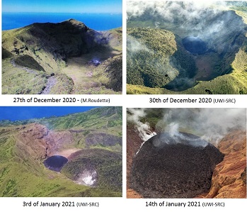
Evolution of the new dome (Soufriere Saint-Vincent)
 - 19th of march.jpg)
Soufriere Saint Vincent lava dome footprint between 27th of December 2020 and 19th of March 2021 ( UWI-SRC document)
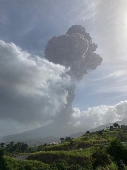
Explosion on 9th of April 2021 (UWI-SRC)
ECUADOR - Tungurahua volcano
October 27th, 2022
IGEPN reported that on Wednesday, October 26th, from approximately 7:00 p.m. TL, the Achupashal station in Tungurahua, recorded seismic signals corresponding to the descent of mudslides and debris (lahars) from the Tungurahua volcano. It is important to highlight that the Baños-Penipe highway crosses the mouth of this ravine, so the circulation of vehicles must be careful in case secondary lahars descend towards said highway.IGEPN informed that through the Volcanic Observers Network (ROVE) and IGEPN cameras recorded on Monday January 3, 2022, a process of resuspension of ash on the northwest flank of the Tungurahua volcano. This process is recorded from around 12:00 TL and is due to the strong winds in the area and the dry climate. There is no change in the internal activity of the Tungurahua volcano. The Geophysical Institute of the National Polytechnic School is monitoring the activity of the volcano and will report on any changes that may be recorded. Previous news 2021 - As of the 7th of June, IGEPN reported that the latest earthquakes felt in the town of Baños, of magnitudes less than 2.9 and shallow, were associated with faults nearby. They do not pose a threat to the population. Monitoring of the volcano remains permanent; its surface activity is very low, and the internal activity remains low, both unchanged. Previous news 2020 -IGEPN reported that on November 15th from 6:40 am local, the seismic stations BULB and BILB of the Tungurahua volcano recorded a high frequency signal, perhaps associated with the appearance of mudslides and debris (lahars) which descended the drainages of the volcano. Proximity to rivers was not recommended. IGEPN can make a connection with the information of November 9 which mentionned a process of resuspension of ash in the upper part of Tungurahua, following strong winds blowing towards the north-west. (NOAA - IGEPN satellite image) Previous news dated 2016 - IG reported that during 27 September-4 October seismic activity at Tungurahua remained at moderate levels, characterized by 1-8 long-period earthquakes and up to three volcano-tectonic events per day. An hour-long period of tremor was recorded on 1 October. Minor fumarolic emissions rose above the crater rim. IG reported that Tungurahua's seismic network detected a significant increase in the number of long-period (LP) earthquakes on 12 September and small episodes of tremor beginning on 16 September. A swarm of 24 LP events were detected during 0408-0424 on 18 September. Starting at 1400 on 24 September the number of LP events again increased. Gas emissions were low, and together with the increased seismicity, possibly indicates a blocked conduit. IG noted that a possible large-scale eruption may happen within hours to days. In response, the Secretaria de Gestion de Riesgos (SGR) announced that the Alert Level was raised from Yellow to Orange (the second highest on a 4-color scale) on 26 September. Previously IG reported that activity at Tungurahua was at moderate-to-high levels during 16-17 March, moderate levels during 18-21 March, and low levels on 22 March. Cloud cover prevented views of the volcano; the weather cleared for a brief period on 20 March and no activity was observed. IG reported that moderate-to-high levels of activity at Tungurahua continued during 9-15 March. Gas-and-ash plumes rose from the crater on most days, often to heights less than 2 km above the crater, and drifted NW, W, WSW, and SW; cloud cover sometimes obscured views of the volcano. Explosions were recorded daily, and crater incandescence was reported almost nightly. Ash fell on 9 March in Pillate (8 km W), El Manzano (8 km SW), Cotalo (8 km NW), and Macas. On 10 March a small pyroclastic flow traveled 1.5 km NW down the Achupashal drainage. On 15 March residents in the Runten sector (NNE) heard an explosion and sounds resembling rolling rocks on the NE flank. Ash fell in Patate (NW) and Juive (7 km NNW). Tungurahua stratovolcano towers more than 3 km above its northern base. It sits ~140 km S of Quito, Ecuador's capital city, and is one of Ecuador's most active volcanoes. Historical eruptions have all originated from the summit crater. They have been accompanied by strong explosions and sometimes by pyroclastic flows and lava flows that reached populated areas at the volcano's base. The last major eruption took place from 1916 to 1918, although minor activity continued until 1925. The latest eruption began in October 1999 and prompted temporary evacuation of the town of Baños on the N side of the volcano. Tungurahua - Live webcam
ECUADOR - Cotopaxi volcano
June 1st, 2023
As of the 31st of may, IGEPN reported that the explosive eruption at the volcano continues at moderate levels.
It is characterized by near-constant vulcanian-type explosions releasing mostly dense grey ash columns to estimated 21,000 ft (6,400 m) altitude that drifted west and southwest. The seismic instrument continues to register long-period earthquakes and tremors associated with gas, water vapor and ash emissions.
The MOUNTS system registered a flux of sulfur dioxide (SO2) emissions to be measured at 392 tonnes on 29 May.
As of the 5th of May, IGEPN reported that the explosive eruption at the volcano continues. The activity is characterized mainly by near-continuous ash emissions and sporadic strong vulcanian-sized explosions.
An intense eruption appeared from the summit vent in the afternoon yesterday, spewing a dense grey ash column to estimated 24,000 ft (7,300 m) altitude that drifted southwest. Seismic records registered 28 long-period earthquakes and 2 tremor events over the past 24 hours.
The MOUNTS system registered a flux of sulfur dioxide (SO2) emissions which reached 98.2 tonnes on 3 May.As of the 1st of May, the explosive activity at the volcano continues with near-frequent small to moderate ash emissions.
According to the Instituto Geofísico (IGEPN), ash columns reached 6,4 km (21,000 ft) elevation over the past week and drifted in the west and south-west direction, respectively. The seismic station recorded 10 long-period, 50 volcano-tectonic earthquakes and 1 tremor event over the past 24 hours.As of the 19th of April, the explosive activity at the volcano continues with near-frequent small to moderate ash emissions, intermittent stronger vulcanian-type eruptions and venting of gas and steam emissions (so-called degassing).
According to the Volcanic Ash Advisory Center (VAAC) Washington, ash column heights have ranged between 6,7 and 7 km altitude over the past few days and drifted in the east and south-west direction, respectively. The MOUNTS system registered a flux of sulfur dioxide (SO2) emissions which reached 51 tonnes on 18 April.As of the 9th of April, explosive activity continues. Volcanic Ash Advisory Center (VAAC) Washington warned about a volcanic ash plume that rose up to estimated 23000 ft (7000 m) altitude or flight level 230 and is moving at 5 kts in E direction.IG reported that eruptive activity at Cotopaxi was ongoing during 29
March-4 April. Gas-and-ash plumes visible in webcam images and reported by
the Washington VAAC during 28-29 March rose as high as 2 km above the
summit and drifted SE and N. Minor ashfall was reported in Machachi (23 km
NW), El Chasqui (17 km W), and Latacunga (34 km SW). Gas-and-steam plumes
were seen rising 100-300 m during 30-31 March. Ash-and-gas plumes rose as
high as 1 km and drifted W during 1-2 April. Gas-and-steam plumes rose 1 km
and drifted W on 3 April. Servicio Nacional de Gestion de Riesgos y
Emergencias (SNGRE) maintained the Alert Level at Yellow (the second lowest
level on a four-color scale).The Instituto Geofisico (IG) issued a special report on 21/03/23 outlining changes in the current eruptive period at Cotopaxi, which began on October 21, 2022. There is evidence of declining volcanic activity, with a decrease in monitoring parameters within the volcanic system and at the surface.
During the current eruptive period, the most common volcanic product has been ash emissions, which were most intense between December 2022 – February 2023, averaging ten events per week. In comparison, the week of March 13 – March 20 recorded only two ash emissions. The current rate is less than one event every two days.IG reported that the eruption at Cotopaxi continued during 1st February -7 March. Several daily ash, gas, and steam plumes rose as high as 1.5 km above the summit during 28 February-2 March and drifted W and SW. Minor ashfall was reported in Mulaló parish (Colcas-Ticatilín) of the Latacunga canton during the afternoon of 28 February.
Steam-and-gas emissions were visible rising as high as 700 m and drifting SW and W during 3-7 March. Minor ashfall was reported in Mulaló parish on 5 March.As of the 1st of March, IGEPN rported that the explosive activity at the volcano continues with near-frequent small to moderate ash emissions and intermittent larger vulcanian-type eruptions.
According to the Volcanic Ash Advisory Center (VAAC) Washington, dense grey-to-black ash column heights ranged between 6,7 km and 7,3 km (22,000 ft-25,000 ft ) elevation over the past week and drifted in the west and south-west direction, respectively. The MOUNTS system registered a flux of sulfur dioxide (SO2) emissions which reached 35 tonnes on 28 January.
The seismic station recorded 26 long-period and 1 volcano-tectonic earthquakes over the past 24 hours.IG reported that the eruption at Cotopaxi continued during 14-21 February,
characterized by almost daily emissions of gas, steam, and ash; inclement
weather conditions occasionally prevented views. Gas emissions with some
ash rose as high as 600 m above the crater rim and drifted E, SE, and SW
during 14-15 February. Minor ashfall was noted in San Ramon (17 km SW),
Ticatian (15 km WSW), San Agusin del Callo (18 km WSW), Mulala (19 km
SW), and Lasso (20 km WSW). Daily ash-and-gas plumes rose as high as 1.1 km
during 16-19 February and drifted mainly E, SE, S, and SW. Minor amounts of
ash occasionally fell on the downwind flanks. During 20-21 February
steam-and-gas plumes rose as high as 1.3 km and drifted E and SW. Servicio
Nacional de Gestion de Riesgos y Emergencias (SNGRE) maintained the Alert
Level at Yellow (the second lowest level on a four-color scale).As of the 12th of February, the explosive activity at the volcano continues with near-frequent small to moderate ash emissions and intermittent larger vulcanian-type eruptions.
According to the Volcanic Ash Advisory Center (VAAC) Washington, ash column heights have ranged between 6,1 and 7,3 km altitude over the past few days and drifted in the south-west and north-west direction, respectively. The MOUNTS system registered a flux of sulfur dioxide (SO2) emissions which reached 546 tonnes on 25 January.As of the 26th of January IGEPN reported that the explosive activity at the volcano continues with near-frequent small to moderate ash emissions and intermittent larger vulcanian-type eruptions.
According to the Volcanic Ash Advisory Center (VAAC) Washington, ash column heights have ranged between 6,1 and 7,3 km altitude over the past few days and drifted in the south-west, north-west and north direction. The MOUNTS system registered a flux of sulfur dioxide (SO2) emissions which reached 215 tonnes on 25 January. As of the 21st of January, IG reported that the explosive activity at the volcano continues with near-frequent small to moderate ash emissions and intermittent larger vulcanian-type eruptions.
According to the Volcanic Ash Advisory Center (VAAC) Washington, ash column heights have ranged between 6,7 and 7,6 km altitude over the past few days and drifted in the east-southeast direction. The MOUNTS system registered a flux of sulfur dioxide (SO2) emissions which reached 1796 tonnes on 20 January.IG reported that the eruption at Cotopaxi continued during 11-17 January,
characterized by daily steam-and-gas emissions often with variable content.
On 11 January ash plumes rose as high as 200 m above the crater rim and
drifted W and SW. Minor ashfall was noted in areas of Mula, Macala
Grande, San Antonio, San Ramon (127 km W), Ticatilan (15 km SW), and MAE
Norte (18 km N), and a sulfur odor was noted in Ticatilan and Control Caspi
(20 km WSW) of the Parque Nacional Cotopaxi. On 12 January steam, gas, and
ash plumes rose as high as 1 km and drifted SE, SW, and W. On 13 January a
dense ash plume rose 2 km and drifted NE, causing ashfall in Ticatilan;
other ash plumes rose 1 km and drifted W and N that same day. Steam-and-gas
emissions rose 300-700 m during 14-17 January and drifted E, SE, and SW.
Ash-and-gas plumes rose 1 km on 17 January and drifted W and SW; minor
ashfall was reported in Mulaló and San Juan de Pastocalle (20 km WSW).
Servicio Nacional de Gestion de Riesgos y Emergencias (SNGRE) maintained
the Alert Level at Yellow (the second lowest level on a four-color scale).As of the 8th of January, IG reported that the explosive activity at the volcano continues at moderate levels.
Minor short-lived eruptions and near-frequent gas and water vapor emissions continue to take place from the main crater, rising to estimated 6,7 km height. According to the MOUNTS system, sulfur dioxide (SO2) emissions reached to a 811 tonnes on 7 January.IG reported that the low-level eruption at Cotopaxi continued during 28
December 2022-3 January 2023, characterized by daily steam-and-gas
emissions with occasional low ash content. Several gas-and-steam emissions
with low ash content were visible on 28 December rising 600-900 m above the
summit and drifting W. Sulfur dioxide emissions were 1,314-2,550 tons per
day during 27-28 December based on satellite data. Only gas emissions were
visible during 29 December-2 January, though weather clouds often prevented
webcam and satellite observations. At 1740 on 3 January a diffuse ash plume
rose 1 km above the summit and drifted W, based on a satellite image. Minor
ashfall was possible in areas to the W. Servicio Nacional de Gestion de
Riesgos y Emergencias (SNGRE) maintained the Alert Level at Yellow (the
second lowest level on a four-color scale). Previous news 2022 -As of the 26th of december, IGEPN reported that xplosive activity continues. Volcanic Ash Advisory Center (VAAC) Washington warned about a volcanic ash plume that rose up to estimated 22000 ft (6700 m) altitude or flight level 220 .On 23 December IG issued a special report about increased activity at
Cotopaxi. A total of 27 ash emissions had been recorded since the eruption
began on 21 October; one ash emission was recorded in October, four were
recorded in November, and 22 were recorded by 23 December. Based on
Washington VAAC notices, ash clouds drifted the farthest, 60 km NNW, on 26
November and 20 December after rising 2.2 km (the maximum recorded height)
and 1.5 km above the crater rim, respectively. Ashfall on those two days
was reported in the Mesa, Rumiahui, and Quito regions. Ash samples from
21 October and 26 November revealed a slight increase in the total
percentage of juvenile material; an analysis of 20 December ash was in
progress. Increases in sulfur dioxide emissions were measured both by
satellite and ground-based Differential Optical Absorption Spectroscopy
(DOAS) instruments. Gas measurements taken during periodic overflights
showed increases in the ratio of sulfur dioxide to hydrogen sulfide. Based
on these and other monitoring data, IG reiterated that the activity was
caused by magma in the volcano’s conduit, though not from new magma
entering the system after the 2015 eruption.The volcano is being constantly monitored since the new eruptive phase began in late October.
On 9 Dec, the Instituto Geofísico in collaboration with the Ecuadorian Armed Forces and National Risk and Emergency Management Service crew made another overflight to measure temperatures and gas emissions equipped with a proper technique to do that.
Thermal images were taken by using a portable infrared camera which is able to distinguish temperature contrast between meteorological clouds (blue) and volcanic plumes (red, yellow and green).
Primary gas emission (SO2, CO2, H2S) samples were taken by using a multiGAS device and visual cameras. At that time, low emissions of gas and water vapor rose only 500 meters above the summit crater extending west of the volcano.As of the 8th of December, IGEPN reported that the eruptive activity at the volcano continues.
Near-constant emissions of ash, gas and water vapor from the crater have been observed by surveillance cameras at Sincholahua between 08:00 and 08:19 local time yesterday morning. The plume continued to dissipate towards the west-northwest and rose up to 7 km altitude.
Continuing ash emissions from Cotopaxi volcano yesterday As of the 23rd of November, IGEPN reported that since the explosive eruption occurred at the volcano on 21 October, a strong constant degassing continues to be active from the summit vent.
Surveillance cameras located on the Sincholagua (northeast) and Rumiñahui (northwest) volcanoes observed gas and steam plumes that have been rising 2 km above the crater.
Although, the activity is still characterized as low-leveled.
Ground deformation data follow the pattern of deflation (subsidence) on the western slopes rather than inflation (uplift), portrayed as blue in the attached InSAR image.
Crater temperatures depict similar values to those after the 2015 eruption. The maximum recorded temperatures reached about 98 °C, however, are underestimated due to an abundant presence of gases and vapor.
Thus, a risk of an impending eruption remains high as a certain rate of uncertainty prevails in monitoring data and volcano behavior so far. As of the 2nd of Nomber IG issued a report that included data analysis and additional information about the minor eruptive activity at Cotopaxi recorded during 21-22 October. The eruption began with a high-frequency earthquake recorded at 1944 on 21 October and was followed by an episode of volcanic tremor from 1950 on 21 October to 0040 on 22 October. A diffuse gas-and-ash cloud rose 1.7-2.3 km above the summit and drifted NE. As of the 22nd of October G reported minor eruptive activity at Cotopaxi. A low-amplitude tremor signal recorded by the seismic network from 1950 on 21 October to 0040 on 22 October was associated with gas-and-ash emissions. The emissions were not visible due to darkness and weather conditions, but minor ashfall and a sulfur odor was reported by mountaineers in the Refugio José Rivas, 2 km N of the summit crater; the mountaineers evacuated. The symmetrical, glacier-covered, Cotopaxi stratovolcano is Ecuador's most well-known volcano and one of its most active. The steep-sided cone is capped by nested summit craters, the largest of which is about 550 x 800 m in diameter. Deep valleys scoured by lahars radiate from the summit of the andesitic volcano, and large andesitic lava flows extend to its base. The modern edifice has been constructed since a major collapse sometime prior to about 5,000 years ago. Pyroclastic flows (often confused in historical accounts with lava flows) have accompanied many explosive eruptions, and lahars have frequently devastated adjacent valleys. Strong eruptions took place in 1744, 1768, and 1877. Pyroclastic flows descended all sides of the volcano in 1877, and lahars traveled more than 100 km into the Pacific Ocean and western Amazon basin. Smaller eruptions have been frequent since that time.(GVN/GVP)
ECUADOR - Reventador volcano
September 8th, 2025
IG-EPN) reported that the eruption continued at Reventador between 4 September 2025 (local) and 5 September 2025 (local). The alert level at Reventador remained at "3 - Orange" (on a 4-level scale). There were 73 seismically detected explosions reported. Plumes rose to a maximum of 1,000 meters (3,281 feet) above the vent. There were observed incandescent rockfalls.IG-EPN reported that the eruption continued at Reventador between 2 September 2025 (local) and 3 September 2025 (local). The alert level at Reventador remained at "3 - Orange" (on a 4-level scale). There were 75 seismically detected explosions reported. Plumes rose to a maximum of 900 meters (2,953 feet) above the vent. There were observed incandescent rockfalls. Crater incandescence was observed during the night on 2 September.As of the 24th of April, the effusive-explosive eruption of the volcano continues and has remained essentially unchanged. Near-constant vulcanian explosions continue to take place from the summit crater that reached 4,6 km (15,000 ft) height and drifted north and northwest over the past few days. Multiple incandescent avalanches continue to be observed, reaching length of at least 900-1,200 meters from the summit vent. As of the 9th of April, the effusive-explosive eruption of the volcano continues and has remained essentially unchanged. Near-constant vulcanian explosions continue to take place from the summit crater that reached 4,3 km (14,000 ft) height and drifted west and northwest over the past few days. Multiple incandescent avalanches continue to be observed, reaching length of at least 900-1,200 meters from the summit vent. Lahars (mud flows) could also occur if heavy rainfalls remobilise the fresh ash deposits. As of the 7th of January, the explosive eruption of the volcano continues and has remained essentially unchanged. Near-constant small short-lived vulcanian explosions continue to take place from the summit crater that reached 4,6 km (15,000 ft) height and drifted into various directions, but most often to west and southwest directions. Incandescent blocks of the lava continue to be observed on the southern flank tumbling down at about 900 meters distance from the summit. Previous news 2024 - As of the 30th of September, the effusive-explosive eruption of the volcano continues and has remained essentially unchanged. Near-frequent vulcanian explosions continue to take place from the summit crater that reached 4,3 km-6,1 km (14,000 ft-20,000 ft) height and drifted north, west and northwest over the past few days. The viscous lava flow on the northeastern flank remains active. Incandescent blocks of the lava continue to be observed on the southern flank, tumbling down about 800 meters distance from the summit.As of the 14th of May, the effusive-explosive eruption of the volcano continues and has remained essentially unchanged. Near-frequent vulcanian explosions continue to take place from the summit crater that reached 4,3 km (14,000 ft) height and drifted west, northwest and southwest over the past few days. The viscous lava flow on the northeastern flank remains active. Incandescent blocks of the lava continue to be observed on the southern flank, tumbling down about 800 meters distance from the summit.As of the 1st of april, the effusive-explosive eruption of the volcano continues and has remained essentially unchanged. Near-frequent vulcanian explosions continue to take place from the summit crater that reached 4,3 km (14,000 ft) height and drifted west and northwest over the past few days. The viscous lava flow on the northeastern flank remains active. Incandescent blocks of the lava continue to be observed on the southern flank, tumbling down about 500 meters distance from the summit.As of the 17th of March, the effusive-explosive eruption of the volcano continues and has remained essentially unchanged. Near-frequent vulcanian explosions continue to take place from the summit crater that reached 4,6 km (15,000 ft) height and drifted west and northwest over the past few days. The viscous lava flow on the northeastern flank remains active. Incandescent blocks of the lava continue to be observed on the southern flank, tumbling down about 500 meters distance from the summit. Lahars (mud flows) could also occur if heavy rainfalls remobilise the fresh ash deposits.As of the 10th of March, the effusive-explosive eruption of the volcano continues and has remained essentially unchanged. Near-constant vulcanian explosions continue to take place from the summit crater that reached heights between 4,3 km and 4,9 km (14,000 ft-16,000 ft) height and drifted west over the past few days. Late night yesterday, a relatively powerful eruption occurred from the summit, showering the mid-to-upper eastern and southern flank with bright lava bombs. The viscous lava flow on the northeastern flank remains active. Incandescent blocks of the lava continue to be observed on the southern flank, tumbling down about 700 meters distance from the summit.As of the 25th of January, the effusive-explosive eruption of the volcano continues and has remained essentially unchanged. Near-constant vulcanian explosions continue to take place from the summit crater that reached 4,6 km (15,000 ft) height and drifted west and southwest over the past few days. The viscous lava flow on the northeastern flank remains active. Incandescent blocks of the lava continue to be observed on the southern flank, tumbling down about 500 meters distance from the summit. Lahars (mud flows) could also occur if heavy rainfalls remobilise the fresh ash deposits. Previous news 2023 - As of the 15th of December, explosive activity continues. Volcanic Ash Advisory Center (VAAC) Washington warned about a volcanic ash plume that rose up to estimated 15000 ft (4600 m) altitude or flight level 150 .As of the 12th of December, the effusive-explosive eruption of the volcano continues and has remained essentially unchanged. Near-constant vulcanian explosions continue to take place from the summit crater that reached 4,6 km (15,000 ft) height and drifted west and northwest over the past few days. The viscous lava flow on the northeastern flank remains active. Incandescent blocks of the lava continue to be observed on the southern flank, tumbling down several hundred of meters distance from the summit.As of the 11th of December, the effusive-explosive eruption of the volcano continues and has remained essentially unchanged. Near-constant vulcanian explosions continue to take place from the summit crater that reached 4,6 km (15,000 ft) height and drifted west and northwest over the past few days. The viscous lava flow on the northeastern flank remains active. Incandescent blocks of the lava continue to be observed on the southern flank, tumbling down several hundred of meters distance from the summit. Lahars (mud flows) could also occur if heavy rainfalls remobilise the fresh ash deposits.As of the 20th of November, the effusive-explosive eruption of the volcano continues and has remained essentially unchanged. Near-constant vulcanian explosions continue to take place from the summit crater that reached 4,6 km (15,000 ft) height and drifted west and northwest over the past few days. The viscous lava flow on the northeastern flank remains active. Incandescent blocks of the lava continue to be observed on the southern flank, tumbling down several hundred of meters distance from the summit. Lahars (mud flows) could also occur if heavy rainfalls remobilise the fresh ash deposits. As of the 9th of October, the effusive-explosive eruption of the volcano continues and has remained essentially unchanged. Near-constant vulcanian explosions continue to take place from the summit crater that reached 4,6 km (15,000 ft) height and drifted west and northwest over the past few days. The viscous lava flow on the northeastern flank remains active. Incandescent blocks of the lava continue to be observed on the southern flank, tumbling down several hundred of meters distance from the summit. Lahars (mud flows) could also occur if heavy rainfalls remobilise the fresh ash deposits.As of (the 23rd of August the effusive-explosive eruption of the volcano continues and has remained essentially unchanged. Near-constant vulcanian explosions continue to take place from the summit crater that reached 4,6 km (15,000 ft) height and drifted west and northwest over the past few days. The viscous lava flow on the northeastern flank remains active. Incandescent blocks of the lava continue to be observed on the southern flank, tumbling down several hundred of meters distance from the summit.As of the 21st of August, explosive activity continues. Volcanic Ash Advisory Center (VAAC) Washington warned about a volcanic ash plume that rose up to estimated 14000 ft (4300 m) altitude or flight level 140 .As of the 15th of August, the effusive-explosive eruption of the volcano continues and has remained essentially unchanged. Near-constant vulcanian explosions continue to take place from the summit crater that reached 4,6 km (15,000 ft) height and drifted west and northwest over the past few days. The viscous lava flow on the northeastern flank remains active. Incandescent blocks of the lava continue to be observed on the southern flank, tumbling down several hundred of meters distance from the summit.As of the 7th of August, IGEPN reported that the effusive-explosive eruption of the volcano continues and has remained essentially unchanged. Near-constant vulcanian explosions continue to take place from the summit crater that reached 4,6 km (15,000 ft) height and drifted west and northwest over the past few days. The viscous lava flow on the northeastern flank remains active. Incandescent blocks of the lava continue to be observed on the southern flank, tumbling down several hundred of meters distance from the summit.As of the 17th of May, IGEPN reported that the effusive-explosive eruption of the volcano continues and has remained essentially unchanged. Near-constant vulcanian explosions continue to take place from the summit crater that reached 4,6 km (15,000 ft) height and drifted into various directions, but most often to northwest and northeast directions. The lava flow on the northeastern flank remains active. Incandescent blocks of the lava continue to be observed on the southern flank tumbling down at about 700 meters distance from the summit.As of the 8th of May, IGEPN reported that the effusive-explosive eruption of the volcano continues and has remained essentially unchanged. Near-constant vulcanian explosions continue to take place from the summit crater that reached 4,6 km (15,000 ft) height and drifted into various directions, but most often to west and southwest directions.The lava flow on the northeastern flank remains active. According to MIROVA Detection System a low thermal anomaly was detected in satellite images over the past 24 hours. Incandescent blocks of the lava continue to be observed on the southern flank tumbling down at about 700 meters distance from the summit.As of the 12th of April, IGEPN reported that the effusive-explosive eruption of the volcano continues and has remained essentially unchanged. Near-constant vulcanian explosions continue to take place from the summit crater that reached 4,6 km (15,000 ft) height and drifted into various directions, but most often to northeast, northwest and west. The lava flow on the northeastern flank remains active. According to MIROVA Detection System a low thermal anomaly was detected in satellite images over the past 24 hours. Sulfur dioxide (SO2) emissions reached to a 121 tonnes on 10 April detected by the MOUNT system.As of the 5th of March, IGEPN reported that vulcanian activity is ongoing and remains almost constant at Reventador. The IG (Geological Institute of Ecuador) reports that between 28/02 - 4/03, despite cloud cover making observation onerous, four ash emissions were recorded, reaching 688 m - 800 m above the crater and leaning northwards. Ballistics, fragments of lava and rock ejected during an explosion were observed landing 500 m down the volcano's flanks. Lava flows were not observed. In the absence of constant obervation, seismic data gives additional insight into the ongoing acivity. During the reported period, 125 seismic events were recorded as a result of explsions and 112 by long-period earthquakes (produced by the movement of magmatic material).As of the 20th of February, IGEPN reported that the effusive-explosive eruption of the volcano continues and has remained essentially unchanged. Near-constant vulcanian explosions continue to take place from the summit crater that reached 4,6 km (15,000 ft), occasionally 5,2 km (17,000 ft) height and drifted into various directions, but most often to northeast. The lava flow on the northeastern flank remains active. IGEPN reported that the effusive-explosive eruption of the volcano continued on 22nd of January and has remained essentially unchanged. Near-constant vulcanian explosions continue to take place from the summit crater that reached elevation between 4,3 km and 4,9 km (16,000 ft) and drifted into various directions, but most often to the southeast and southwest. The active lava flow is being oozed out from the summit vent causing rockfall avalanches that tumble down along the northeastern flank.Previous news 2022 - As of the 27th of December, IGEPN reported that the effusive-explosive eruption of the volcano continues and has remained essentially unchanged. Near-constant vulcanian explosions continue to take place from the summit crater that reached 4,6 km (15,000 ft), occasionally 4,9 km (16,000 ft) height and drifted into various directions, but most often to southwest and northwest. The lava flow on the northeastern flank remains active.The Volcanic Ash Advisory Center (VAAC) Washington reported intermittent emissions of volcanic ash plumes. IG reported that the effusive-explosive eruption of the volcano continues. Near-constant vulcanian explosions continue to take place from the summit vent that reached 15,000 ft (4,600 m) altitude and drifted west and northwest direction.The lava flow continues to be active on the northern flank and slowly advancing downslope. The lava flow continues to be active on the northern flank and slowly advancing downslope.IG described the ongoing eruption at Reventador as moderate during 9-15 November. Daily seismicity was characterized by 18-47 explosions, 22-45 long-period earthquakes, and 2-18 signals that indicated emissions. During 9-12 November there were also 1-4 periods of daily harmonic tremor. Gas, steam, and ash plumes, observed almost daily with webcams or reported by the Washington VAAC, rose as high as 1.3 km above the summit and drifted SAs of the 8th of November, explosive activity continues. Volcanic Ash Advisory Center (VAAC) Washington warned about a volcanic ash plume that rose up to estimated 16000 ft (4900 m) altitude or flight level 160 .As of the 6th of November, IGEPN reported that Mild explosive activity continues from the volcano. The Volcanic Ash Advisory Center (VAAC) Washington reported intermittent emissions of volcanic ash plumes.IGEPN reported moderate surface and internal activity levels continued, and an with unchanged trend. The seismicity on October 18th at 11 a.m. was characterized by 24 explosion earthquakes, 39 LP earthquakes and 6 tremor episodes. For October 19th at 11 a.m., 19 explosion earthquakes were reported, as well as 39 LP earthquakes, and 6 episodes of tremor. VAAC Washington mentionned 3 ash emission alerts less than 1,000 m above the crater on 18th, and 4 emissions at 1,338 m on 19th of October. On October 18th around 11 p.m., incandescence was observed at the crater and at a lava flow on the northeast flank. The explosive-effusive activity remains moderate on September 24th-25th. The REVS reference station for daily seismic statistics transmitted without problems during the last 24 hours: with 64 explosion earthquakes, 19 LP earthquakes, 1 episode of emission tremor, and 6 episodes of harmonic tremor. At the end of the afternoon yesterday the volcano was clear and an emission of steam, gas and ash could be observed moving towards the northeast at more than 1000 meters above the level of the crater. The Washington VAAC issued 3 reports of ash emission 988 meters above the summit in a northeasterly, northwesterly and southwesterly direction. The IGEPN reported for the period from 22d to 23rd of September at 11 a.m. gas and ash emissions observed, reaching heights of up to 1200 meters above the level of the crater in a west and northwest direction. The Washington VAAC reported 3 ash emissions with heights of 1338 meters above the summit in a northwesterly direction.At night and early in the morning, incandescence was observed in the crater and the rolling of blocks up to 600 meters below the summit on all sides of the volcano. The lava flow on the northeast flank remains active. IGEPN rported that on August 24th, several gas and ash emissions were observed with heights of up to 500 meters in a northwest direction. The Washington VAAC recorded 4 ash releases with heights of 988 m to 1638 m, the direction oscillated from northwest to southwest.For August 25th, 3 ash emissions at 1,638 m. above the crater were recorded by VAAC Washington. During the night and early in the morning, an incandescence could be observed at the level of the crater with the descent of blocks along the northeast flank up to 500 meters below the summit, today morning it rose clear and an ash emission was observed 300 meters high above the crater to the northwest. IGEPN reports moderate surface and internal activity levels, however on the rise on the surface for July 29th / 11 a.m. Seismicity was characterized by: 38 explosion earthquakes, 62 Long Period (LP) earthquakes, 11 emission tremor periods. In the morning, several gas emissions with ash were recorded with heights up to 1,000 meters in a northwest direction, in addition the Washington VAAC reported an emission of 688 m above the level of the le summit in a westerly direction. As of the 8th of July, IGEPN reported that moderate levels of surface activity and internal activity, with no changes. Several ash and gas emissions were observed, with heights of 500 to 800 m above the level of the crater and with a direction to the west. The Washington VAAC reported an ash emission with a height of 1338 m above crater level, with a westerly direction. At dawn, an incandescence was observed in the upper part of the volcanic edifice, and an active lava flow in the northeast flank. As of the 27th of June, IG reported that the surface and internal activity continued at moderate levels, with no changes. Seismicity is characterized by 45 explosion earthquakes, 70 LP earthquakes, 13 episodes of emission tremor, and 4 of harmonic tremor On June 16 and 17, gas and ash emissions were observed, ranging up to 1,200 meters, with directions oscillating between SO and NO. The WORLDVIEW system records 3 thermal alerts in the last 12 hours.IG reported that a high level of activity continued during 14-22 June, though cloudy weather conditions sometimes prevented visual observations. Gas-and-ash plumes, often observed multiple times a day with the webcam or reported by the Washington VAAC, rose as high as 1.7 km above the summit and drifted mainly NW and W. Incandescence from the crater was often visible at night or during the early morning.IGEPN reported that on May 26 at the end of the afternoon, an emission of gas and ash was observed in Reventador / Ecuador, with a height of 800 m and a direction towards the West. Thanks to images shared by ECU-911, several emissions were recorded this morning, with heights of less than 2 km. The Washington VAAC reported two ash emissions that reached up to 988 m and the direction was west. No thermal anomaly has been recorded in the past 24 hours. Seismicity is characterized by 40 explosion earthquakes, 63 long-period earthquakes and 4 emission tremors. As of the 18th of May, IGEPN reported that the effusive-explosive eruption of the volcano continues. Near-constant vulcanian explosions continue to take place from the summit vent that reached 15,000 ft (4,600 m) altitude and drifted west direction. The lava flow continues to be active on the northeastern flank. Visibility of the volcano is very limited due to dense clouds for now.IGEPN reported that in the afternoon of 19 and April 20, steam, gas and ash emissions up to 1,000 m. asl. to the Reventador, with dispersion between the north and the northeast. Nocturnal incandescence was observed at the level of the crater.Seismicity is characterized by 25 explosion earthquakes, 62 LP earthquakes and 4 episodes of harmonic tremor. IGEPN reported that at the end of the afternoon of April 15, the volcano cleared and several emissions of steam, gas and ash could be observed with a maximum height of 800 meters above the level of the crater, heading towards the North-west. Reventador is the most frequently active of a chain of Ecuadorian volcanoes in the Cordillera Real, well E of the principal volcanic axis. It is a forested stratovolcano that rises above the remote jungles of the western Amazon basin. A 3-km-wide caldera breached to the E was formed by edifice collapse and is partially filled by a young, unvegetated stratovolcano that rises about 1,300 m above the caldera floor. Reventador has been the source of numerous lava flows as well as explosive eruptions that were visible from Quito in historical time. Frequent lahars in this region of heavy rainfall have constructed a debris plain on the eastern floor of the caldera. (GVN/GVP) - IG webcam
ECUADOR - Sangay volcano
September 8th, 2025
IG-EPN) reported that the eruption continued at Sangay between 4 September 2025 (local) and 5 September 2025 (local). The alert level at Sangay remained at "2 - Yellow" (on a 4-level scale). There were 82 seismically detected explosions reported. Plumes rose to a maximum of 1,000 meters (3,281 feet) above the vent. Incandescence from the crater was observed during the night and early morning.IG-EPN) reported that the eruption continued at Sangay between 2 September 2025 (local) and 3 September 2025 (local). The alert level at Sangay remained at "2 - Yellow" (on a 4-level scale). There were 33 seismically detected explosions reported. Incandescence from the crater was observed during the night on 2 September.Previous news 2024 - As of the 6th of October, the explosive activity continues. Volcanic Ash Advisory Center (VAAC) Washington warned about a volcanic ash plume that rose up to estimated 22000 ft (6700 m) altitude or flight level 220 .As of the 10th of July, the effusive-explosive eruption of the volcano continues. The lava flow on the SE flank continues to be active. Near-frequent vulcanian eruptions continue to generate ash columns spewing pyroclastic material to approx. 6,1 km (20,000 ft) elevation in the western direction over the past few days. Most of the ejected hot, juvenile and glowing material slid down along the southeastern flank in the form of incandescent avalanches. IG-EPN reported that high levels of eruptive activity continued at Sangay during 11-18 June. Gas-and-ash plumes were visible in webcam and/or satellite images on most days rising as high as 1.5 km above the summit and drifted WNW, W, WSW, and SW. During the morning of 12 June ashfall was reported in Cebadas (35 km WNW) and Reten Ichubamba (35 km WNW), Cantón Guamote (35 km WNW), province of Chimborazo, and in the cantons of Naranjito (121 km W), Guayaquil (175 km W), Samborondón (170 km W), and Daule (185 km W), in the province of Guayas. Incandescent material at the crater was visible during the dark hours of 11-13 June, and several episodes of incandescent material traveling as far as 2.5 km down the SE flank were visible during 11-14 June.As of the 3rd of April, the effusive-explosive eruption of the volcano continues. The lava flow on the SE flank remains active, and slowly advance nearly to the base of the edifice at about 2000 m distance from the summit. Near-frequent vulcanian eruptions continue to generate ash columns releasing pyroclastic material to approx. 6,1 km (20,000 ft) elevation in the western-northwestern direction over the past week. Most of the ejected hot, juvenile and glowing material slid down along the southeastern flank in the form of incandescent avalanches.As of the 21st of March, the effusive-explosive eruption of the volcano continues. The lava continues to travel onto the SE flank ravine, keep the flow active and slowly advance nearly to the base of the edifice at about 2000 m distance from the summit. Near-frequent vulcanian eruptions continue to produce ash columns spewing pyroclastic material to approx. 5,8 km (19,000 ft) elevation in the western-southwestern direction over the past week. Most of the ejected hot, juvenile and glowing material slid down along the southeastern flank in the form of incandescent avalanches.As of the 13th of February, the effusive-explosive eruption of the volcano continues. The lava continues to emerge onto the SE flank ravine, keep the flow active and slowly advance nearly to the base of the edifice. Near-frequent vulcanian eruptions continue to produce ash columns releasing pyroclastic material to approx. 6,1 km-7 km (20,000 ft-23,000 ft) elevation in the western-southwestern direction. Most of the ejected hot, juvenile and glowing material slid down along the southeastern flank in the form of incandescent avalanches. IG-EPN reported a high level of eruptive activity at Sangay during 9-16 January, with seismic stations recording 232-626 daily explosions. Ash-and-gas plumes were visible in both webcam and satellite images during 9-14 January, rising as high as 1.5 km above the crater rim and drifting W, WSW, and SW. On 12 January an explosion deposited incandescent material on all flanks as far as 1 km from the summit crater. At 1810 that same day a pyroclastic density current descended the SE drainage and an ash plume rose 1 km above the summit and drifted SW. Crater incandescence was sometimes visible at night, and during 11-12 and 13-14 January incandescent material was observed descending the SE drainage as far as 1 km. Cloudy weather prevented views during 15-16 January, though crater incandescence was observed overnight. SecretarÃa de Gestión de Riesgos maintained the Alert Level at Yellow (the second highest level on a four-color scale). Previous news 2023 - As of the 1st of October, the effusive-explosive eruption of the volcano continues and remains essentially unchanged. The lava continues to emerge onto the SE flank ravine, keep the flow active and causes frequent glowing rockfalls as flow front blocks detach from the flow reaching length of at least 1800 m. Near-frequent vulcanian eruptions continue to produce ash columns, releasing pyroclastic material to approx.20,000 ft - 23,000 ft (6,1 km -7 km) elevation in the western-southwestern direction. Most of the ejected hot, juvenile and glowing material slid down along the southeastern flank in the form of incandescent avalanches. According to MIROVA Detection System, a high thermal anomaly (561 MW) was identified in satellite images over the past 24 hours.As of the 28th of August, the effusive-explosive eruption of the volcano continues and remains essentially unchanged. The lava continues to emerge onto the SE flank ravine, keep the flow active and slowly advance about 1000 meters distance from the summit. Near-frequent vulcanian eruptions continue to produce ash columns, releasing pyroclastic material to approx.20,000 ft - 23,000 ft (6,1 km -7 km) elevation in the western-southwestern direction. Most of the ejected hot, juvenile and glowing material slid down along the southeastern flank in the form of incandescent avalanches. According to MIROVA Detection System, four high thermal anomalies (455,475,398 and 335 MW) were detected in satellite images over the past 24 hours.As of the 31st of July, the effusive-explosive eruption of the volcano continues. The lava continues to emerge onto the SE flank ravine, keep the flow active and slowly advance nearly to the base of the edifice. Near-frequent vulcanian eruptions continue to produce ash columns releasing pyroclastic material to approx. 6,1 km (20,000 ft) elevation in the western-southwestern direction. Most of the ejected hot, juvenile and glowing material slid down along the southeastern flank in the form of incandescent avalanches. Heavy rainfalls occurred in the area of the volcano. Nonetheless, no debris avalanches and/or lahars were detected. In addition, the flow rate has increased in the Upano river. The current hazards pose lahars (mud flows) which could also occur if heavy rainfalls remobilise the fresh ash deposits.As of the 29th of June, IGEPN reported that the effusive-explosive eruption of the volcano continues. The lava continues to spill out onto the SE flank ravine, keeping the flow active and slowly advancing until about halfway to the base of the edifice. Near-frequent vulcanian eruptions continue to produce ash columns releasing pyroclastic material to approx. 56,1 km (20,000 ft) elevation in the western-southwestern direction. Most of the ejected hot, juvenile and glowing material slid down along the southeastern flank in the form of incandescent avalanches. Satellite-based measurements of SO2 concentrations were detected in plumes of about 58 tonnes yesterday. According to MIROVA Detection System, a high thermal anomaly (118 MW) was detected in satellite images over the past 24 hours. Yesterday afternoon, heavy rainfalls were observed in the area of the volcano. Nonetheless, no debris avalanches and/or lahars were detected. In addition, the flow rate has increased in the Upano river. The current hazards pose lahars (mud flows) which could also occur if heavy rainfalls remobilise the fresh ash deposits.As of the 29th of May, IGEPN reported that the volcano showed a dramatic activity. A strong, dilute pyroclastic flow (gravity-driven mass flow) appeared to descend over the southeastern flank in early this morning. The reason for this torrent is not clear yet, but from previous observations at the volcano, it might come from continuous glowing rock falls on the southern slope and its sudden accumulation and destabilization culminating into pyroclastic density currents as happened today. Pyroclastic flows are deadly, turbulent hot avalanche of lava rock fragments of all sizes embedded in a mixture of turbulent gas and ash racing down slopes. Near-frequent vulcanian eruptions continue to produce ash columns releasing pyroclastic material to approx. 5,8 km-6,1 km (19,000 ft-20,000ft) in the western-northwestern direction. Satellite-based measurements of SO2 concentrations were detected in plumes of about 759 tonnes on 1 March.As of the 23rd of April, IG reported that two stronger-than-usual eruptions occurred at the volcano over the past few hours. Dense ash emissions rose about 26,000 ft (8,000 m) above the summit crater and drifted to the southwest of the volcano where tephra covered surfaces in the province of Chimborazo (Guamote, Cebadas and Matriz).) Most of the ejected hot, juvenile and glowing material slid down along the southeastern flank in the form of incandescent avalanches. Satellite-based measurements of SO2 concentrations were detected in plumes of about 495 tonnes on 21 April.As of the 20th of March, IGEPN reported that the effusive-explosive eruption of the volcano continues. From available webcam imagery on 18 March, it seems a fresh batch of magma has been shifting through the main conduit. Most of the red, hot fluid lava has flowed directly from the summit crater into the southeastern flank ravine. Simultaneously, strombolian activity has been picking up at the summit vent while erupting. This also confirms a stunning satellite image of the elevated effusive activity of Sangay acquired by Sentinel-2. Near-frequent vulcanian eruptions continue to produce ash columns releasing pyroclastic material to approx. 5,8 km (19,000 ft), occasionally up to 6,1 km (20,000 ft) elevation in the eastern direction. Most of the ejected hot, juvenile and glowing material slid down along the southeastern flank in the form of incandescent avalanches. Satellite-based measurements of SO2 concentrations were detected in plumes of about 208 tonnes on 18 March.Over the past week, explsoive activity has dominated at Sangay volcano. Dispite intermittent thick cloud cover, ash and gas plumes were observed on five of the last seven days. The erupted plumes of ash and gas ranged in height between 560 m - 1000 m above the crater and leaned north, northwest, southwest and southeast. The last observation of effusive activity (lava flow) was recorded on March 2nd. Rainfall occurred on all but one day. This is significant as Sangay is prone to secondary lahars, which are formed when volcanic material mixes with water to form volcanic mud flows, which at Sangay flow down river pathways, notably the Volcan and the Upano.As of the 2nd of March, IGEPN reported that the effusive-explosive eruption of the volcano continues. The lava continues to spill out onto the SE flank ravine, keeping the flow active and slowly advancing until about halfway to the base of the edifice. Near-frequent vulcanian eruptions continue to produce ash columns releasing pyroclastic material to approx. 5,8 km (19,000 ft), occasionally up to 7,3 km (24,000 ft) elevation in the western direction. Most of the ejected hot, juvenile and glowing material slid down along the southeastern flank in the form of incandescent avalanches. Satellite-based measurements of SO2 concentrations were detected in plumes of about 759 tonnes on 1 March.IG reported a high level of activity at Sangay during 14-21 February, which included daily explosions, long-period earthquakes, periods of tremor, and gas, steam, and ash emissions. The daily count of explosions ranged from 30-56, though the daily seismic data transmission was sometimes interrupted. Almost daily gas, steam, and ash plumes were either observed in IG webcam images or described in Washington VAAC volcanic activity notifications; weather clouds often prevented observations of the summit. The plumes rose as high as 1.8 km above the volcano and drifted mainly E, SE, and W. Multiple thermal anomalies were identified in satellite images on most days. Incandescence from the crater, a 500-m-long lava flow on the SE flank, and rolling blocks were visible during the nights of 14-15 and 18-19 February. Servicio Nacional de Gestión de Riesgos y Emergencias (SNGRE) maintained the Alert Level at Yellow (the second lowest level on a four-color scale).As of the 5th of February, IGEPN reported that the activity at the volcano remains unchanged. Continuing lava flows continue to be active on the SE flank. Near-frequent vulcanian eruptions continue to produce ash columns sending pyroclastic material to approx. 6,1 km (20,000 ft) in the north-northwestern direction. Most of the ejected hot, juvenile and glowing material slid down along the southeastern flank in the form of incandescent avalanches. Satellite-based measurements of SO2 concentrations were detected in plumes of about 1,551 tonnes on 3 February.The isolated Sangay volcano, located east of the Andean crest, is the southernmost of Ecuador's volcanoes and its most active. The steep-sided, glacier-covered, dominantly andesitic volcano grew within horseshoe-shaped calderas of two previous edifices, which were destroyed by collapse to the east, producing large debris avalanches that reached the Amazonian lowlands. The modern edifice dates back to at least 14,000 years ago. It towers above the tropical jungle on the east side; on the other sides flat plains of ash have been sculpted by heavy rains into steep-walled canyons up to 600 m deep. The earliest report of a historical eruption was in 1628. More or less continuous eruptions were reported from 1728 until 1916, and again from 1934 to the present. The almost constant activity has caused frequent changes to the morphology of the summit crater complex. (GVN/GVP)
ECUADOR - Wolf volcano (Galapagos)
May 8th, 2022
On 5 May IG reported that the eruption at Wolf's SE flank was over. The
eruption began at 2320 on 6 January from an approximately 8-km-long radial
fissure, trending NW-SE, that had at least five active vents. Lava flows
from the vents traveled SE then E, covering an area of more than 30 square
kilometers. The maximum length of the flow field was 18.5 km, with the
farthest-reaching flow stopping 150-200 m from the coastline. The highest
levels of heat, sulfur dioxide emissions, seismicity, and deformation were
recorded in the early days of the eruption. Sulfur dioxide emissions had
been absent for the previous 30 days.A s of the 6th of May.
The latest available satellite image from 1 May seems to confirm that the lava flow has stopped its advance about 150-200 meters off the ocean shore and started to cool itself gradually. According to the local volcano observatory Instituto Geofísico (IG), the reported length of the lava flow is about 18,5 km covering more than 30 km2 of the area.
The seismic activity has continued at decreasing levels.IG reported that the eruption at Wolf continued during 13-18 April. Lava
flows continued to advance towards the coast based on thermal data;
satellite images showed minor advancement during 11-16 April and the end of
the flow near the coastline.IG reported that the eruption at Wolf continued during 5-12 April. Minor
sulfur dioxide emissions were recorded during 5-6 April. Thermal data
captured and mapped on 6 April indicated that lava flows were getting
closer to the coast; daily thermal alert counts, as many as around 154,
indicated active and advancing lava flows during the rest of the week.
IG reported that the eruption at Wolf continued during 22-29 March. Daily
thermal alert counts, as many as around 200, indicated active and advancing
lava flows on the SSE flank.As of the 21st of March, IGEPN reported that volcano's surface and internal activity levels remain high, with a decreasing trend.
Between March 20 and 21 / 11 a.m., the IGEPN recorded 3 volcano-tectonic earthquakes
The MOUNTS system recorded 12.6 tons of SO2 on 03/20/2022 at 2:15 p.m. TL.
FIRMS registers 63 thermal alerts and MIROVA registers 1 high thermal alert (1276 MW) and 1 moderate alerts at Wolf (between 210 and 491 MW) during the last 24 hours.
The thermal anomalies of the GOES-16 satellite are maintained due to the advance of the flows of lava.As of the 16th of March, IGEPN reported that hermal anomalies are still recorded. Surface and internal activity levels remain high, unchanged. Thanks to the images provided by the GOES-16 satellite, thermal anomalies can be observed due to the effect of the advance of the lava, which has still not reached the coast. No seismic event has been recorded at the volcano in the past 24 hours. IGEPN reported that on 12.03.2022 / 11 a.m., a volcano-tectonic earthquake during the last 24 hours.The FIRMS system recorded 159 thermal alerts. The MIROVA system recorded 2 thermal alerts
high (889 MW and 606 MW).The observatory has uploaded an animation of the weekly advance of lava flows in Wolf Volcano. The current eruption began on January 6 this year. The animation was created using information from daily thermal anomalies recorded by NASA's FIRMS satellite system. IGEPN reported that thermal anomalies are still reported at Wolf Volcano on March 11, 2022: The FIRMS system recorded 91 thermal alerts. The MIROVA system recorded 2 moderate thermal alerts, 1 high (471 MW) and 1 very high (1840 MW). In the MOUNTS system, 31.8 tonnes of SO2 were recorded, with data from March 10.
Seismicity comes down to a single Volcano-tectonic earthquake (VT). As of the 6th of March, IGEPN reported that the activity, both superficial and internal, of the Wolf volcano remained high, with an unchanged trend. Thermal anomalies continue to appear on satellite images, associated with the presence of lava flows. The MIROVA system recorded 3 very high thermal anomalies (1089, 1139 and 1859 MW) and the WORLDVIEW system recorded 106 thermal alerts over the past 24 hours.Seismicity comes down to a single volcano-tectonic earthquake. No good satellite view as the Galapagos were covered with clouds. IGEPN reported that activity of the Wolf volcano continued on 28th of February. FIRMS registers 229 thermal alerts and MIROVA registers 2 high thermal alerts (181 and 974 MW) and 1 very high (2012 MW) in the last 24 hours
These thermal anomalies on the satellite are due to advancing lava. Only one volcano-tectonic earthquake is reported in the last 24 hours. Thermal anomalies continue to be observed at Wolf Volcano by satellites, due to advancing lava.The WORLSVIEW system recorded 170 thermal alerts in the last 12 hours and MIROVA recorded 4 very high thermal alerts (1783, 1424, 2343 and 2364 MW) at the Wolf as of February 25, 2022.on February 26, the WORLDVIEW system recorded more than 100 thermal alerts, and MIROVA recorded 2 high thermal alerts (105 and 999 M.W.) and 1 very high (1522 M.W.) in the last 24 hours.Seismicity is limited to one daily LP earthquake. The GOES-16 satellite images show no anomalies on 22nd of February at 13:20 UTC (TL Galapagos -6HS) at Wolf Volcano.
At the seismic level: only one volcano-tectonic earthquake were mentioned by the IGEPN.
No VAAC alert or ash emission report was recorded. WORLdVIEW records 171 thermal alerts at Wolf, in the last 12 hours MIROVA records very high thermal alerts, in the last 24 hours
During the night, the thermal anomaly recorded by the satellites was maintained. The eruption of the Wolf volcano, which began on January 6, 2022, continues.
As of the 16th of February thermal anomalies have been observed in satellite images at Volcan Wolf, in the Galapagos archipelago. FIRMS records 235 thermal alerts; while MIROVA registers 1 high thermal alert (748 MW) and 3 very high (1617, 1537 and 2142 MW). These thermal anomalies are related to lava flows. As of the 9th of February FIRMS recorded 309 thermal alerts, while MIROVA records 3 very high thermal alerts, of VRP 1876, 3727 and 4714 MW, and a high alert of VRP 670 MW in the last 24 time. No emission was observed by the GOES-16 satellite. On the map of lava flows established on February 8, 2022, we can see that since mid-January, a flow has been mainly fed in a south-southwest direction; another heading west. The lava field has widened but the flows have still not reached the coast. Only one Volcano-tectonic earthquake has been recorded in the last 24 hours. As of the 2nd of February MIROVA recorded 3 very high thermal anomalies (6005 MW, 3392 MW and 1532 MW) and 1 moderate, while FIRMS recorded more than a hundred thermal anomalies during of the last 24 hours.These anomalies are related to lava flows to the south.WORLDVIEW applications recorded 18 thermal anomalies and MIROVA recorded 1 high thermal anomaly (672 MW), and three smaller ones on January 30 in the past 24 hours. At 19:52 UTC, through the MOUNTS project, a measurement of 2,173 t of SO2 is recorded for the Wolf volcano. Surface and internal activity levels remain high, although decreasing. IGEPN reported that the eruption continued from January 18th-25th. Daily thermal alerts numbered in the hundreds, centered on advancing lava flows on the SE flank. Diffuse gas emissions were visible drifting SW from 18 to 20 January. The level of activity remained stable at the beginning of the week then began a downward trend from 21 January.On January 26 / 11 a.m., the IG reports a large-period (LP) earthquake. IGPEN reported that the level of surface and internal activity of the Wolf volcano remains high, but decreasing.
Only two long-period earthquakes are mentioned in the last 24 hours.
There is no observation of gas emissions in the satellite images.
MIROVA reported thermal anomalies for this January 21, between 122 and 5729 MW, and FIRMS recorded hundreds of thermal alerts in 24 hours, observed due to advancing lava flows.Light ash emissions were observed by satellite at Wolf Volcano drifting southwest on January 19.Thermal alerts are broadcast by Mirova and FIRMS, in connection with lava flows. Seismicity is characterized by 3 LP earthquakes. Satellite monitoring of Wolf Volcano, Galapagos, shows that thermal anomalies are continuing on January 18, 2022. The MIROVA system reports 2 very high (2,190 and 7,581 MW) and 1 extreme (14,048 MW) thermal alerts in the last 24 hours, and the WORLDVIEW system reports hundreds of thermal alerts. They are due to lava flows that have not yet reached the sea. Slight gas emissions were observed on the satellite towards the southwest. At the seismic level, only three LP earthquakes are reported. The effusive eruption of the volcano continues.
A satellite image from 16 January identified that the lava flow, being active from two eruptive fissures, branched off into two lava arms traveling east. The larger (northern) lava tongue didn't make it to the sea yet, 2 kilometers have been leaving to the ocean entry.
According to MIROVA Detection System, extreme thermal anomalies (14000 MW-17000 MW) continue to detect in satellite images.As of the 16th of January, IGEPN reported that superficial and internal activity of the Wolf volcano remains high, but with a downward trend.. On January 16 in the evening, slight gas emissions were observed in a southwesterly direction, on an image from the GOES-16 satellite. MIROVA is reporting extreme thermal anomalies on January 16-17, while FIRMS is reporting hundreds of thermal alerts over the past 24 hours.
Satellite monitoring shows that thermal anomalies are continuing. During the last 24 hours, the seismicity is characterized by a volcano-tectonic earthquake and 3 LP earthquakes. As of the 15th of January, according to IGEPN eruptivze activity is continuing. Very weak gas emissions, in a southwesterly direction, were observed thanks to satellite images at the Wolf volcano on 13th of January. The MIROVA satellite system reported 1 extreme thermal alert (11728 MW), 2 very high (7571 and 8791 MW) and 1 high (200 MW) and FIRMS reported more than 100 thermal alerts in Wolf, in the last 24 hours. On the satellite images, we observe that the thermal anomalies are gradually weakening.
However, although unlikely, new pulses of lava flow emission are not excluded. As of the 12th of January, two active eruptive fissures continue to keep the lava flow active while the highest vent shows signs of inactivity. The total length of the lava flow is about 16,5 km and 15 km length of the active flow and haven't reached the sea entry yet. According to the latest official data, the area covered by lava flows amounts to 7,6 km per square in total.As of the 9th of January, GOES-16 satellite images show the gas emission column from the eruption of Wolf volcano in the Galapagos, looking southwest. The Washington VAAC reported four alerts, mostly for gas, with heights up to 700 meters above sea level and heading southwest. GOES 16 satellite images at 11:20 UTC (TL GALÁPAGOS: UTC-6) show that the thermal anomaly associated with the lava flows has slightly altered its course from SSE to E. The lava flows continue to move towards the sea , situation on January 9, 2022/11 a.m.
The WORLDVIEW satellite system has reported hundreds of thermal alerts to Wolf during the past 12 hours. As of the 8th of December, IGEPN reported that eruption continues. The Washington VAAC reported four emissions, mostly gas, with average heights of 1,300 meters and a westerly direction on January 8, 2022. The MIROVA satellite system reported 2 extreme thermal anomalies, respectively VRP 38,693 and 30,045 MW, mainly associated with lava flows. The FIRMS system reported more than a hundred thermal alerts in the last 12 hours. On satellite images, it was possible to observe gas emission columns and thermal anomalies associated with lava flows. The seismicity is characterized by 40 explosion earthquakes, and 9 emission tremor episodes between 07.01 and 08.01 at 11 a.m. IGEPN reported that on on Friday January 7, 2022 from 00:20 TL (23:20 on January 06, 2022 local time) a new fissure eruption was observed at the level of the volcano Wolf. (Photo) Seismic recording from the FER1 station, located in the Galapagos Islands, shows that at approximately 9:00 p.m. local time in the Galapagos, a seismic swarm occurred. At 9:35 p.m., an earthquake of magnitude 2.4 was recorded, with its epicenter at the Wolf volcano. From 11:15 pm TL Galapagos, a tremor signal can be observed, probably associated with the onset of the eruption. All of these signals were of low amplitude because the FER1 station is located on Fernandina Island. At 01:20 TL (00:20 TL Galapagos) on January 07, 2022, a cloud of gas and ash is visible on satellite images, reaching heights between 3,793 m asl in the northeast (NE) and 1,943 m asl in the west (W); There is no population near the volcano or towards the ash clouds. The FIRMS satellite system shows several thermal alerts located on the southern and southeastern flanks of the volcano. These alerts are associated with the high temperatures generated by the eruptive fissure and lava flows.Observation confirmed that the opened crack south of Wolf volcano where magma emerges in the same direction, towards the interior of the island. The columns of gas and ash reach several thousand meters in height (between 1900 and 3800 meters) and are directed to the north, then the west of the island, where there is no human population at risk. Previous eruptive activity occurred in 2015. Wolf, the highest volcano of the Galápagos Islands, straddles the equator at the north end of the archipelago's largest island, Isabela. The 1710-m-high edifice has steeper slopes than most other Isabela volcanoes, reaching angles up to 35 degrees. A 6 x 7 km caldera, at 700 m one of the deepest of the Galápagos Islands, is located at the summit. A prominent bench on the west side of the caldera rises 450 above the caldera floor, much of which is covered by a lava flow erupted in 1982. Radial fissures concentrated along diffuse rift zones extend down the north, NW, and SE flanks, and submarine vents lie beyond the north and NW fissures. Similar unvegetated flows originating from a circumferential chain of spatter and scoria cones on the eastern caldera rim drape the forested flanks to the sea. The proportion of aa lava flows at Volcán Wolf exceeds that of other Galápagos volcanoes. An eruption in in 1797 was the first documented historical eruption in the Galápagos Islands. (GVN/GVP)
ECUADOR - Sierra Negra volcano (Galapagos)
September 2nd, 2018
As of the 1st of September IG reported that due to the continuous decrease in seismic energy levels, reaching even earlier values at the beginning of the eruptive period from June to August 2018 at the Sierra Negra volcano, and the decrease in the number of thermal alerts and SO2 emission , the IGEPN reported the possible end of the eruptive activity or the entry into a period of calm after 58 days of eruption. By 25 August the lava flows in total covered an area of 30.6 square kilometers. Activity continued to decline the last week of August with decreased seismicity, gas emission, and no surficial activity visible. . IG reported that during 20-21 August both steam-and-gas emissions and incandescence from lava flows were visible on the Sierra Negra webcam. No activity was noted when the weather was clear during 22-28 August. On 15 August satellite images showed lava from Fissure 4 continuing to enter the ocean. IG reported that the eruption at Sierra Negra continued during 7-14 August. Incandescence from active NNW lava flows was visible almost nightly. A steam-and-gas plume rose 1.8 km a.s.l. and drifted W on 7 August. IG reported that on August 9, at 17:45 GMT, the tremor increased in amplitude, in relation with a new surge of activity on the northern flank.Seismicity is further characterized by 52 volcano-tectonic earthquakes, and 6 LP earthquakes.The largest earthquake occurred at 10:55 am M3,1 TG and a depth of 2 km. IG reported that the eruption at Sierra Negra continued during 1-7 August. Incandescence from active lava flows was visible daily. An increase of tremor began at 2220 on 3 August and lasted two hours, signifying a new pulse of activity on the N flank. Small gas emissions were visible on 4 August, and steam-and-gas emissions were noted on 6 August. IG reported that the eruption at Sierra Negra continued during 25-31 July. Sulfur dioxide flux was as high as about 1,400 tons per day (on 28 July), and daily counts of volcano-tectonic and long-period events were 24-65 and 3-32, respectively. Nightly incandescence from advancing lava flows was visible. Gas plumes rose more than 1.8 km above the vents and drifted N, NW, and W. As of the 20th of July, IGEPN reported that the activity remains unchanged, at a superficial and high internal level.During the last measurement period, 18 to 19 July at 11am, the number of VT earthquakes decreased, with 39 events; the number of LP earthquakes is 11.The gas emissions are at least 1,800 meters above sea level, and go to the WNW.Nighttime glow is observed at the emission points, and on the lava flows.As of the 10th of July, IGEPN reported that Sierra Negra's surface and internal activity levels remain high. The eruptive process continues, as evidenced by numerous volcano-tectonic earthquakes and emission tremor; thermal anomalies are noted as well as the emission of a plume of vapor, gas and ash rising to 2,400 meters in height, then moving towards the southwest sparing the populated areas for the moment. Lava flows come from a source located in the lower part of the northwestern flank of the volcano; the emission of lava would have increased significantly since July 7 at 17h local. From July 2nd to 3rd at 11am local time, the IG reports 241 volcano-tectonic earthquakes, 37 LP earthquakes and 2 VLP earthquakes. During the last 24 hours, about fifty volcanic earthquakes have been located at a depth of less than 5 km; the strongest was on the east flank of the volcano, at a depth of 2 km, with a magnitude of 3.4.The satellite images show gas and vapor emissions, and the presence of lava flows. IGEPN reported that after a small earthquake on July 1, 2018 at 15:52 GMT, tremor appeared. At 18 o'clock, the National Park staff reports incandescence and the presence of lava flows on the northwest flank of the volcano. The IGEPN informs, for the period from 01 to 11 am to 02 July at 11 am, 286 volcano-tectonic earthquakes, 43 LP earthquakes, 3 VLP earthquakes and emission tremor. An ash emission was mounted 1,000 meters above the crater, then headed west. IGEPN reported that the activity of the past 12 hours was characterized by a gradual decrease in seismic and acoustic tremor, but these signals nevertheless indicate the continuation of the eruption with a lower intensity.One hundred and two volcano-tectonic earthquakes have been recorded; the largest, with a magnitude of 3.3, is located south of the caldera at a depth of 4.3 km. The others are located at a shallower depth, and in the western part of the caldera. Previously, IGEPN and PNG reported that following a rise in seismicity for some months, and some more recent major earthquakes, including one of M 4.2 on June 22 at 6:24 GMT and another of M 5.3 on June 26 at 3:15 GMT under the Sierra Negra volcano / Isabela Island to the Galapagos, the seismicity was marked by replicas and tremor. On June 26, from 11:17 am TG, a new seismic swarm began in Sierra Negra; earthquakes are characterized by a depth of between 3 and 5 km and a magnitude of 4.6 maximum. Since the earthquake of M 4,2 at 13:38 TG, the amplitude of seismicity and infrasonic signals has greatly increased. Galapagos National Park staff reported rumbles from the volcano. all these signs suggest the beginning of the eruptive process. Images from the GOES-16 Satellite show a strong thermal anomaly in the northern area of the caldera. The Park staff then reported lava flows inside the caldera and on the northern flank of the volcano towards Bahia Elizabeth. As Isabela Island is populated, the authorities have ordered the evacuation of 50 residents, who will be cared for by host families; tourist access to the Sierra Negra volcano area and the El Cura area is restricted. On 8 June IG reported a continuing high level of seismicity at Sierra Negra, characterized by a larger number and magnitude of earthquakes, indicating magma movement. The number of events per day had been significantly increasing since mid-2016. In the previous 10 days there was an average of 42 local events/day; on 25 May there were 104 events, the largest number of earthquakes per day recorded since 2015. In addition, in a 24-hour period during 7-8 June there were a total of 48 volcano-tectonic events, two long-period events, and three hybrid earthquakes; a M 4.8 long-period earthquake was recorded at 0715 on 8 June. The earthquake epicenters were mainly located on the edges of the crater, in two NE-SW trending lineaments; the first covered the N and W edges of the crater and the second went from the NE part around to the S edge. Data showed very large deformation at the caldera's center, compared with lower levels of deformation outside of the caldera. The broad shield volcano of Sierra Negra at the southern end of Isabela Island contains a shallow 7 x 10.5 km caldera that is the largest in the Galápagos Islands. Flank vents abound, including cinder cones and spatter cones concentrated along an ENE-trending rift system and tuff cones along the coast and forming offshore islands. The 1124-m-high volcano is elongated in a NE direction. Although it is the largest of the five major Isabela volcanoes, it has the flattest slopes, averaging less than 5 degrees and diminishing to 2 degrees near the coast. A sinuous 14-km-long, N-S-trending ridge occupies the west part of the caldera floor, which lies only about 100 m below its rim. Volcan de Azufre, the largest fumarolic area in the Galapagos Islands, lies within a graben between this ridge and the west caldera wall. Lava flows from a major eruption in 1979 extend all the way to the north coast from circumferential fissure vents on the upper northern flank. Sierra Negra, along with Cerro Azul and Volcan Wolf, is one of the most active of Isabela Island volcanoes. (GVN/GVP)
ECUADOR - Fernandina volcano (Galapagos)
May 24th, 2024
As of the 22nd of May, the effusive eruption at the volcano continues. As indicated in the satellite image on May 15, a very faint thermal signal (SWIR) of lava flow emissions on the southern flank has been captured, suggesting that the activity seems to be weakening. According to the MIROVA Detection System, a moderate thermal anomaly (27 MW) was detected in satellite images on 22 May.As of the 5th of May, the effusive eruption at the volcano continues. Judging from the latest Sentinel-2 satellite image two days ago, the lava persists, sustaining its flow and progressing in the formation of the lava delta along the southern coastline. The active lava flow covers an area of approximately 16.2 square kilometers with a length of 13.4 kilometers. Sulfur dioxide (SO2) emissions reached 625.5 tonnes at 13:19 local time on 1 May. According to the MIROVA Detection System, a high thermal anomaly (556 MW) was detected in satellite images the day before. As of the 18th of April, the effusive eruption at the volcano continues. Although the lava flow advance seems to have slowed down a bit due to a lesser amount of gas-steam emissions at the new lava delta identified in the latest satellite image, it still continuse to be active and feed the shoreline. Sulfur dioxide (SO2) emissions reached 325 tonnes at 13:00 local time on 16 April. According to the MIROVA Detection System, a high thermal anomaly (589 MW) was detected in satellite images this morning. As of the 16th of April, the effusive eruption at the volcano continues. The lava flow advance seems to have slowed down a bit due to a lesser amount of gas-steam emissions at the new lava delta, identified in the PlanetScope satellite image from 13 April. Sulfur dioxide (SO2) emissions reached 120.3 tonnes at 02:55 local on 13 April. According to the MIROVA Detection System, a moderate thermal anomaly (14 MW) was detected in satellite images on 14th of April. As of the 9th of April, the effusive eruption at the volcano continues. Since the lava flow front made it to the ocean on 7 April, it continues to expand the coastline by building a new beach bench known as the lava delta. In addition, the lava at the contact with water is likely developing another kinds of volcanic edifices, known as littoral cones. The water, reacting with lava, will quickly generate steam explosions, so-called laze (lava haze), blasting out showers of solid-to-semisolid fragments derived from the outer part of the flow. As the volcano is uninhabited, there is no threat to the population.Previously, the Galapagos National Park institute reported that the advancing lava flow at the volcano entered the ocean on 7 April. Over the past month since the eruption commenced, the lava has been traveling over the entire length of the southern slope until it reached the shoreline. The lava at the contact with water started to develop other kinds of volcanic edifices, known as littoral cones. The water, reacting with lava, will quickly generate steam explosions, so-called laze (lava haze), blasting out showers of solid-to-semisolid fragments derived from the outer part of the flow. As the volcano is uninhabited, there is no threat to the population.As of the 1st of April, the effusive eruption of the volcano continues. The lava flow on the south-southwestern flank remains active and continues to advance towards the shoreline, currently about 2,6 km from the ocean entry.. Once the lava interacts with water, it does so explosively, forming abundant steam-gas emissions, so called laze (lava haze).As of the 25th of March, the effusive eruption of the volcano continues. The lava flow on the south-southwestern flank remains active and continues to advance towards the shoreline, currently about 2,7 km from the ocean entry. Once the lava interacts with water, it does so explosively, forming abundant steam-gas emissions, so called laze (lava haze). According to the MIROVA Detection System, a very high thermal anomaly (1037 MW) was detected in satellite images on 23rd of March. As of the 17th of March, the effusive eruption at the volcano continues. According to the latest Sentinel-2 satellite image of the eruption, acquired on March 16th, a cluster of several vents feeds the lava, which continues to keep the flow active on the south-southwestern flank. The lava flow has increased in length, currently about 8.9 km and slowly travels towards the shoreline, about 3.4 km from the sea entry. Once the lava interacts with water, it does so explosively, forming abundant steam-gas emissions, so called laze (lava haze).As of the 15th of March the low-level effusive eruption at the volcano continues. The lava flow gradually continues to slow down its advance over the past few days. According to the MIROVA Detection System, a high thermal anomaly (619 MW) was detected in satellite images yesterday. Sulfur dioxide (SO2) emissions reached to a 576 tonnes measured on 13 March. Gas and steam emissions have extended west-southwest of the volcano. No ash emissions have been recorded over the past 24 hours.As of the 13th of March, the effusive activity of the volcano continues at reduced levels. The lava flow gradually continues to slow down its advance over the past few days. This confirmed the GOES-16 satellite system as well when a slight thermal anomaly of the volcano was identified yesterday. However, according to the MIROVA Detection System, a very high thermal anomaly (5192 MW) was detected in satellite images the day before. Sulfur dioxide (SO2) emissions reached to a 2500.4 tonnes measured on 11 March. Gas and steam emissions have extended west-southwest of the volcano. As the volcano is uninhabited, there is no threat to the population.As of the 7th of March, the effusive eruption at the volcano goes on. Lava flows continue to be active on the south-southeastern flank of the volcano, currently about 7,8 km long (from the flank fissure up to the flow front). Lava hasn't made it to the ocean yet, and it is still uncertain whether it'll eventually reach the sea. Otherwise, when lava interacts with water, it does so explosively, forming abundant steam-gas emissions. According to the MIROVA Detection System, a very high thermal anomaly (7592 MW) was detected in satellite images in the afternoon on 7 March. The recent satellite image of the eruption depicts a forest fire located west of the lava flow. Gas and steam emissions have extended west-southwest of the volcano, reaching a height of several hundreds of meters above the crater.As of the 5th of March, the effusive eruption at the volcano continues. Several lava flow arms, oozing from the flank fissure, continue to be active on the south-southeastern slope of the volcano. Lava hasn't made it to the ocean yet, and it is still uncertain whether it'll eventually reach the sea. Otherwise, when lava interacts with water, it does so explosively, forming abundant steam-gas emissions. Low gas and steam emissions with no ash traces had been dispersed west-southwest. Sulfur dioxide (SO2) emissions reached to a 46,457 tonnes measured at 01:27 on 3 March/ The new eruption commenced at the volcano on 3rd of March. At 11:50 PM local time, a new lava effusion began to emerge from a 3-5 km long eruptive fissure in the upper part of the southeastern slope of the volcano. The eruption has been producing multiple lava flows over the flank, reaching length of at least 5-6 km from the fissure. Lava flows have not yet reached the ocean, and it is still uncertain whether they will eventually make it to the sea. The onset of the new effusive eruption was identified by the GOES-16 and VIIRS satellites. Moreover, the near-polar satellites SUOMI-NPP and NOAA-20 have recorded more than 1000 thermal anomalies during their passage over the Galapagos at 00:44 and 01:35 local time tonight. A gas-steam plume containing some amount has been rising about 2-3 km above the summit towards the west, north-northwest and south-southeast. Previous news 2021 - As of the 17th of November, IG reported that slow deformation at Fernandina has been recorded over the previous 18 months. InSAR data showed that inflation was occurring at a rate of about 400 mm/year in the summit caldera and on the NE flank, while deflation was occurring at a rate of about 100-400 mm/year in areas on the upper W and SW flanks. On 13 October the areas of deflation changed to inflation and the rate of deformation in the caldera increased. On 17 November IG noted that fumarolic activity in the summit crater was visible during the previous few days and may have been related to a small episode of tremor on 16 November. IG also noted that periodic fumarolic activity and small episodes of tremor are common at Fernandina without an eruption.Fernandina, the most active of Galápagos volcanoes and the one closest to the Galápagos mantle plume, is a basaltic shield volcano with a deep 5 x 6.5 km summit caldera. The volcano displays the classic "overturned soup bowl" profile of Galápagos shield volcanoes. Its caldera is elongated in a NW-SE direction and formed during several episodes of collapse. Circumferential fissures surround the caldera and were instrumental in growth of the volcano. Reporting has been poor in this uninhabited western end of the archipelago, and even a 1981 eruption was not witnessed at the time. In 1968 the caldera floor dropped 350 m following a major explosive eruption. Subsequent eruptions, mostly from vents located on or near the caldera boundary faults, have produced lava flows inside the caldera as well as those in 1995 that reached the coast from a SW-flank vent. Collapse of a nearly 1 km3 section of the east caldera wall during an eruption in 1988 produced a debris-avalanche deposit that covered much of the caldera floor and absorbed the caldera lake. (GVN/GVP)
***************************************************************************************************************************************************************************************************
Tungurahua volcano from Pelileo
MEXICO - Popocatepetl volcano
October 31st, 2024
As of the 19th of May, the explosive eruption at the volcano continues. Emissions of water vapor, gases and small amounts of ash have been registered from the summit crater that propagated northwest in an altitude of approx. 20,000 ft (6,100 m). The seismic station registered 92 minutes of volcanic tremor on 18 May. The alert level for the volcano remains at Level 2. Previous news 2024 - As of the 31st of October, the eruptive activity of the volcano persists. Strong ash emissions and intermittent vulcanian-sized explosions continue from the crater. On 29 October, incandescent material covered the upper edifice's cone by throwing lava bombs and lapilli, which in turn created small glowing rockfalls. The seismic instrument detected approx. 1,400 minutes of low-to-moderate amplitude tremor last night. The crater area of the volcano remains closed for climbing as the risk of being caught in sudden explosions is very high. The alert status remains at Level 2.As of the 14th of October, explosive activity continues. Volcanic Ash Advisory Center (VAAC) Washington warned about a volcanic ash plume that rose up to estimated 22000 ft (6700 m) altitude or flight level 220 .CENAPRED reported that eruptive activity continued at Popocatépetl during 25 June-2 July. The seismic network recorded 10-51 long-period events per day that were accompanied by steam-and-gas emissions; the emissions sometimes contained minor amounts of ash. Weather clouds sometimes prevented visual observations. The seismic network also recorded daily periods of tremor as short as 14 minutes to as long as five and a half hours. As of the 29th of February, he intense activity at the volcano continues. Near-constant and copious ash emissions had been rising to 21,000 ft-24,000 ft (6,400 m-7,300 m) and extending about 180 km to the north-northeast of the volcano over the past 24 hours, as is identified in the attached satellite imagery. Due to continuing periods of copious ash columns, moderate rain of very fine ash particles was reported over the past several days in several municipalities around the volcano. As of the 28th of February,the volcano has been dominated by strong ash emissions over the past week. Due to continuing periods of copious ash columns, moderate rain of very fine ash particles was reported yesterday in the municipalities of Hueyapan, Yecapixtla and Tetela del Volcán, Morelos; in Ixtacuixtla, Panotla, Tepetitla, Nativitas, Zacatelco, Santa Apolonia Teacalco, San Damián Texóloc, Tetlahuaca, Zacatelco, Xicohtzingo, Paplotla, Tenancingo, Santa Catarina Ayometla, Magdalena Tlaltelulco, San Francisco Tetlanohcan and Teolocholco, Tlaxcala; in Iztacalco, Iztapalapa and Coyoacán, Mexico City; and finally in Atlautla, Ayapango, Ecatzingo, Chalco, Tenango del Aire, Temamatla, Ozumba, Tepetlixpa, Tlalmanalco and Amecameca, State of Mexico.As of the 26th of February, persisting dense ash emissions had been continuing from the summit vent most of the day yesterday. A considerable load of lapilli and fine ash material spewed to estimated 22,000 ft (6,7 km) elevation and drifted SE. The CENAPRED seismic station registered periods of a low-amplitude, high-frequency volcanic tremor lasting about 1300 minutes. The crater area of the volcano remains closed for climbing as the risk of being caught in sudden explosions is very high. The alert status remains at Level 2.A period of strong ash emissions occurred from the volcano's crater on 21st of February. At about noon, a sustained, grey, dense and billowing ash column could be seen rising from the summit vent via surveillance cameras. The plume rose approx. to 6,1 km elevation and drifted SW. An ashfall has been reported in the municipalities of Hueyapan, Tetela del Volcano and Jiutepec in Morelos. The elevated volcanic tremor had continued today. The CENAPRED volcano observatory reported a seismic signal with a mean amplitude of 918 minutes. The crater area of the volcano remains closed for climbing as the risk of being caught in sudden explosions is very high. The alert status remains at Level 2.As of the 20th of February, the explosive eruption at the volcano continues. According to the Volcanic Ash Advisory Center (VAAC) Washington. vulcanian-sized explosions continues to occur from the summit vent at roughly regular intervals of 2 to 3 per day. Plumes of ash rose to an altitude ranging between 19,000 ft (5,800 m) and 20,000 ft (6,800 m) over the past week. The seismic station registered 939 minutes of amplitude tremor over the past 24 hours. In general, seismic recordings depict elevated continuous ground vibration duration of approx. 1100 min / day over the past weeks, indicating movement of magma through the volcanic conduit.As of the 29th of January, the explosive eruption at the volcano continues. Vulcanian-sized explosions continues to occur from the summit vent at roughly regular intervals of 2 to 3 per day. Plumes of ash rose to an altitude ranging between 19,000 ft (5,800 m) and 23,000 ft (7,000 m) over the past week. The seismic station registered 972 minutes of amplitude tremor over the past 24 hours. In general, seismic recordings show elevated continuous ground vibration duration of approx. 1300 min / day over the past weeks, indicating movement of magma through the volcanic conduit.CENAPRED reported that eruptive activity continued at Popocatepetl during 9-16 January. Long-period events totaling 6-64 per day were accompanied by steam-and-gas plumes that occasionally contained minor amounts of ash. The plumes mainly drifted ENE and NE. The seismic network recorded 14.5-23 daily hours of tremor, including both low- and high-frequency events. Minor amounts of ash fell in Nealtican (21 km E) during 11-12 January. Ashfall was also reported in Nativitas (40 km NE), Tetlatlahuaca (42 km NE), Zacatelco (45 km NE), Xicohtinco (45 km NE), Ayometla (46 km ENE), Papalotla (62 km NNW), Tenancingo, San Pablo del Monte (49 km E), Mazatecochco (50 km ENE), Tlaxcala (50 km NW), and Tepeyanco (47 km NW) in the state of Tlaxcala on 15 January and in Nealtican, Juan C. Bonilla (32 km ENE), and Tlaltenango in the state of Puebla on 16 January. The Alert Level remained at Yellow, Phase Two (the middle level on a three-color scale) and the public was warned to stay 12 km away from the crater.Previous news 2023 - As of the 18th of December, the explosive activity continues. Volcanic Ash Advisory Center (VAAC) Washington warned about a volcanic ash plume that rose up to estimated 19000 ft (5800 m) altitude or flight level 190 and is moving at 5 kts in S direction.The explosive eruption at the volcano continues at a bit heightened levels within the past two weeks. Popocatépetl is mainly characterized by strong near-constant ash emissions from the summit vent rather than vulcanian-sized explosions. Ash plumes rose to estimated 6-7 km elevation, drifting mostly to the S-SW, occasionally SE direction. About 100 emissions of gas, water wapor and ash on average have been detected during 3-17 November. Seismic recordings registered 1000-1500 minutes of amplitude tremor during this period. Strong ash and lapilli fall have been occurring in the municipalities of Ayapango, Ozumba and Ecatzingo, State of Mexico and Axochiapan, Hueyapan, Tetela del Volcán, Morelos.As of the 14th of November, explosive activity continues. Volcanic Ash Advisory Center (VAAC) Washington warned about a volcanic ash plume that rose up to estimated 20000 ft (6100 m) altitude or flight level 200 .As of the 29th of September, t he explosive eruption at the volcano continues. According to the Volcanic Ash Advisory Center (VAAC) Washington, spewed grey ash columns rose to 20,000 ft-21,000 ft (6,1 km-6,4 km) height and dissipated towards the southwest over the past few days. Additionally, 20 minutes of high-frequency amplitude volcanic tremor have been recorded on 28 September. The alert status remains at Level 2.As of the 27th of August, the explosive activity continues. Volcanic Ash Advisory Center (VAAC) Washington warned about a volcanic ash plume that rose up to estimated 15000 ft (4600 m) altitude or flight level 150. As of the 27th of June, CENAPRED reported that the explosive eruption at the volcano was continuing. Relatively vigorous eruptions occurred from the summit in the morning the day before. At about 06:35 and 08:12 local time, plumes of grey ash rose to an altitude of 20,000 ft-22,000 ft (6,100 m-6,700 m) and drifted west and southwest. Seismic records registered 5178 minutes of amplitude tremor over the past 24 hours associated with 22 emissions of gas, water vapor and ash. In addition, two volcano-tectonic earthquakes were recorded at 15:20 and 21:34 local time yesterday with magnitude M 1.8 and 1.4 A light-to-moderate ash fall has been registered in the municipalities of Amecameca and Ayapango.As of the 7th of June, based on the recommendation of the Comité Científico Asesor (CCA) in participation with the Coordinación Nacional de Protección Civil (CNPC), a decision has been made to decline the current Level 3 alert for the volcano back to Level 2. The decision followed short-term fluctuating levels at the volcano, i.e. there might lead to either increase or decrease in the general activity. Monitored data indicate a slight drop of detected parameters over the last few days, characterized by small amounts of ash emissions, glowing lava bombs, and low-to-moderate amplitude tremor. Vulcanian-type explosions have been mostly mild only, but fluctuated in both frequency and intensity.Another eruptive episode appeared at the volcano in the late afternoon on 4th of June. At about 04:30 PM, after the recent rapid decrease of tremor, a new vigorous lava fountaining (likely to be classified as paroxysm) activity started to throw glowing lapilli-to-bomb-sized lava fragments, indicating rapid magma acceleration within the conduit towards the surface. Sustained hurling of incandescent ejecta accompanied by a typical strong ash-rich bursting continued at least until 08:00 PM.As of the 3rd of June the high-frequency tremor signal has decreased significantly over the past 48 hours, the CENAPRED reported. Seismic records registered 11 minutes of amplitude tremor over the past 24 hours associated with 219 emissions of light amounts of ash and occasional incandescent fragments. Vulcanian activity continues from the summit vent at weakened levels but still remains above long-term average values. Ash plumes continue to reach nearly the same altitudes of about 19,000 ft-20,000 ft (5,800 m-6,100 m) drifting south. The crater area of the volcano remains closed for climbing as the risk of being caught in sudden explosions is very high. The alert status remains at Yellow Phase 3. As of the 20th of May, the high activity dominates the volcano with near-frequent strong vulcanian-type explosions and periods of dense ash emissions from the summit area. Intense powerful explosions continue to generate abundant grey ash plumes spewing to estimated 21,000 ft (6,400 m) elevation associated with glowing bomb ejecta. Soon after landings, the vast edifice area is being constantly illuminated by fragmented incandescent material.As of the 28th of May, CENAPRED reported that the high activity dominates the volcano with near-frequent strong vulcanian-type explosions and periods of dense ash emissions from the summit area. Intense powerful explosions continue to generate abundant grey ash plumes spewing to estimated 21,000 ft (6,400 m) elevation associated with glowing bomb ejecta. Soon after landings, the vast edifice area is being constantly illuminated by fragmented incandescent material. Strong bursting of large amounts of ash emissions continued most of the previous days.As of the 25th of May, CENAPRED reported that the highly elevated explosive activity at the volcano continues. A vigorous bursting of dense ash and gas emissions occurred from the summit crater in the early morning yesterday. The continuous eruption lasted several dozen minutes, generating an ash-rich billowing column to estimated 25,000 ft (7,600 m) in the southeast direction. Strong vulcanian-sizes explosions continue to take place by throwing a large amount of incandescent lava fragments from the summit vent onto the variously oriented slopes. Seismic records registered 1089 minutes of volcano-tectonic tremor and 19 ongoing emissions of water vapor, gas and ash over the past 24 hours.The volcano continues at highly elevated levels. The activity has been picking up on 22nd of May in the early morning as a short-term lava-fountaining eruptive episode took place from the summit vent. From the available webcam imagery, lava jets onset appeared to start at about 05:22 local time by an impressive lava fountain of up to perhaps a hundred meters above the crater, following nearly 6-minute continuous bursting fountaining accompanied by ejecting incandescent lava bombs. The eruptive episode calmed down at approx. 05:28 local time. Dense grey ash emissions continued during the eruption and darkened the sky above Puebla town.CENAPREDreported that the alert status of the volcano was raised to "Level 3", as the activity continues at high levels characterized by stronger-than-usual vulcanian-type explosions. The decision about the alert status change was made by the Scientific Advisory Committeeon 21st of May based on the ongoing volcano's activity. The strong eruptive phase at the volcano continues by throwing a large amount of incandescent lava fragments from the summit crater onto the variously oriented slopes. Grey ash-rich columns reached 32,000 ft (9,800 m) height and drifted E over the past 48 hours.As of the 18th of May, CENAPRED reported that the strong eruptive phase at the volcano has continued during the past several weeks. The activity is dominated by larger-than-usual vulcanian-type explosions, throwing a large amount of incandescent lava fragments from the summit crater onto the variously oriented slopes. The broad area of the edifice is being constantly brightened by these lapilli-to-bomb-sized tephra fragments as some of the lava bombs, visible in the webcam screenshot, fall outside the frame border, meaning that they reached distances greater than 2 km.As of the 16th of May explosive activity continues. Volcanic Ash Advisory Center (VAAC) Washington warned about a volcanic ash plume that rose up to estimated 23000 ft (7000 m) altitude or flight level 230 As of the 15th explosive activity continues. Volcanic Ash Advisory Center (VAAC) Washington warned about a volcanic ash plume that rose up to estimated 20000 ft (6100 m) altitude or flight level 200 .As of the 12th of May, CENAPRED reported that the eruptive activity at the volcano continues at moderately high levels. The volcano observatory recorded five minor-to-moderate vulcanian-sized eruptions over the past 24 hours, of which one (05:26 local time appeared to be powerful. The explosion ejected hot, glowing lava bombs to approx. height of hundred meters above the summit crater following landing onto the upper snow-capped slopes. The eruption sent an ash column to 23,000 ft (7,000 m) height drifting SE. 225 ongoing emissions of water vapor, gas and ash continued most of the morning.CENAPRED) recorded a quite strong eruption in the morning on 12 April. According to the Volcanic Ash Advisory Center (VAAC) Washington, a spewed grey ash column rose to 19,000 ft (5,8 km) height and dissipated towards the southeast. Lava bombs were ejected as far as 2 km away from the crater landing onto the southern flank. Additionally, 160 emissions of water vapor, gases and ash and 364 minutes of volcanic tremor were monitored. Nevertheless, the Volcanic Alert Level remains at Yellow.As of the 3rd of April, the explosive activity continues. Volcanic Ash Advisory Center (VAAC) Washington warned about a volcanic ash plume that rose up to estimated 25000 ft (7600 m) altitude or flight level 250 and is moving at 10 kts in NE direction.As of the 31st of March, CENAPRED reported that explosive activity continues. Volcanic Ash Advisory Center (VAAC) Washington warned about a volcanic ash plume that rose up to estimated 22000 ft (6700 m) altitude or flight level 220 and is moving at 20 kts in NE direction.Vulcanian activity continues from the summit crater. A spectacular explosion took place from the volcano in the evening, at about 06:00 PM local timeon 27th of March. A spectacular grey ash-rich plume rose nearly 2 kilometers above the summit, extending to the southeast of the volcano, the Volcanic Ash Advisory Center (VAAC) Washington reported. According to the local monitoring institute CENAPRED, 227 emissions of water vapor, gases and ash were emitted over the past 24 hours. The internal activity represented 129 minutes of low-amplitude volcanic tremor.As of the 26th of March, CENAPRED reported that the eruptive activity at the volcano continues at moderately high levels. A relatively forceful explosion appeared from the main crater in the late evening yesterday, showering the upper part of the edifice with hot, glowing lava bombs. An eruption plume released ash emissions to estimated 7 km elevation and drifted east. According to the local monitoring institute CENAPRED, 235 emissions of water vapor, gases and ash were emitted over the past 24 hours. The internal activity represented 62 minutes of low-amplitude volcanic tremor including two volcano-tectonic earthquakes with a magnitude of M 1.4.As of the 18th of March, explosive activity continues. Volcanic Ash Advisory Center (VAAC) Washington warned about a volcanic ash plume that rose up to estimated 22000 ft (6700 m) altitude or flight level 220 .As of the 15th of March, CENAPRED's surveillance cameras observed several vulcanian-type explosions over the past 24 hours, of which a powerful one generated glowing hot lava fragments showering most of the upper edifice, including the summit cone. The eruption took place shortly after a midnight yesterday. A released ash was carried to approx. 6,7 km elevation and drifted east direction. Furthermore, 131 passive emissions of water vapor, gas and ash (venting) were detected. The seismic network recorded 15 minutes of internal high and low frequency tremor.As of the 27th of February, CENAPRED reported that several powerful explosions occurred at the volcano over the past few days, otherwise the eruptive activity continues at generally moderate levels. The Centro Nacional de Prevención de Desastres (CENAPRED) recorded quite vigorous eruptions that happened in the mornings of 26 and 27 February. According to the Volcanic Ash Advisory Center (VAAC) Washington, spewed grey ash columns rose to 5,8 km and 6,7 km height and dissipated towards the north and southeast, respectively. Additionally, 51 minutes of low amplitude volcanic tremor have been recorded yesterday.As of th 24th of February , explosive activity continues. Volcanic Ash Advisory Center (VAAC) Washington warned about a volcanic ash plume that rose up to estimated 22000 ft (6700 m) altitude or flight level 220 .CENAPRED reported that there were 102-215 steam-and-gas emissions, often containing ash, rising from PopocatÃepetl each day during 14-21 February; minor explosions also occurred almost daily. Minor explosions were recorded at 1334, 1456, and 1822 on 14 February and at 0253 on 15 February based on data from the seismic network. On 17 February minor explosions occurred at 0210, 1827, 2210, 2252, and 2325. Additional minor explosions were recorded at 0235, 0252, and 0614 on 18 February; a webcam iage from 0236 showed ejected incandescent material on the flanks. The lava dome on the crater floor was visible in satellite images and had not significantly changed since the 27 January overflight. On 20 February a minor explosion was recorded at 1805, and a moderate explosion at 2331 ejected incandescent material onto the upper flanks. A series of five minor explosions were recorded at 0027, 0052, 0252, 0401, and 0529 on 21 February. Ash fell in Amecameca (19 km NW), in the State of Mexico, during 20-21 February. The Alert Level remained at Yellow, Phase Two (the middle level on a three-color scale).As of the 5th of February, CENAPRED reported that he explosive activity at the volcano continues. At about 09:30 local time yesterday morning, an above-average eruption took place from the summit vent triggering an increasingly larger rising thick grey ash column. The pyroclastic material (tephra) was being released to estimated 20,000 ft (6,100 m) that extended towards the SW of the volcano. The seismic station monitored 153 minutes of volcano-tectonic tremor over the past 24 hours. In addition, 317 emissions of water vapor, gases and ash were detected.As of the 21st of January, CENAPRED reported that the explosive eruption at the volcano continues. A significant above-average eruption occurred from its crater at 07:38 local time. The Volcanic Ash Advisory Center (VAAC) Washington detected a tall and dense ash plume that rose up to 28,000 ft (8,500 m) height and drifted northeast.As of the 15th of January, explosive activity continues. Volcanic Ash Advisory Center (VAAC) Washington warned about a volcanic ash plume that rose up to estimated 21000 ft (6400 m) altitude or flight level 210 and is moving at 20 kts in E direction.As of the 10th of January, explosive activity continues. Volcanic Ash Advisory Center (VAAC) Washington warned about a volcanic ash plume that rose up to estimated 22000 ft (6700 m) altitude or flight level 220 and is moving at 40 kts in NE direction.As of the 1st of January 2023, CENAPRED reported that vulcanian activity continues from the main crater. Two spectacular eruptions occurred at the turn of 2022 and 2023. The very last explosion in 2022 appeared to happen at about 11:21 PM local time and later on in approx. two hours at 01:33 AM, the first eruption in 2023 took place. Both eruptions were characterized by ejecting incandescent lava bombs from the crater showering the summit cone spreading into various directions. Moreover, a magnificent lenticular cloud was accompanied during the first eruption above the crater. Lenticular clouds form when moist, stable air flows over a larger swirls, usually formed by mountains, a series of large-scale standing waves form on the leeward side of the mountain. If the temperature at the crest of the wave drops below the dew point, moisture in the air may condense to form these clouds.As of the 20th of December, CENAPRED reported that Vulcanian activity at the volcano continues. A spectacular eruption occurred at 06:39 local time on the morning showering the summit cone and upper edifice with incandescent lava bombs thrown from the crater. Some of the bombs may be part of the growing lava dome in origin, ripped out from it due to the powerful momentum of the explosion. The Volcanic Ash Advisory Center (VAAC) Washington reported about an ash column spewing fine pyroclastic material to estimated 6,5 km altitude. 191 emissions of water vapor, gases and minor amounts of ash have been detected over the past 24 hours, extending NE direction. The seismic network registered 187 minutes of a volcanic tremor and one volcano-tectonic quake with a magnitude M 1.1. As of the 14th of December, CENAPRED reported that the explosive eruption at the volcano continues at moderate levels. Near-constant gas, steam, ash emissions and near-frequent vulcanian-sized explosions continue to take place from the summit crater. According to the Volcanic Ash Advisory Center (VAAC) Washington, ash plume heights varied between 22,000 ft-23,000 ft (6,700 m-7,000 m) altitudes and drifted into W-SW directions over the past few days. The seismic network detected 123 minutes of the low-amplitude volcanic tremor. The small lava dome continues to grow with magma rising into it. The Volcanic Alert Level remains at Yellow.As of the 11th of The explosive eruption at the volcano continues. A strong explosion occurred from the summit crater yesterday morning. The Volcanic Ash Advisory Center (VAAC) Washington detected a tall and dense ash plume that rose up to 23,000 ft (7,000 m) height and drifted south. The eruption was recorded by witnesses from a plane flying over the Mexico City. of the 21st of October, CENAPRED reôrted that during the last 24 hours, 62 exhalations have been detected, accompanied by water vapor, volcanic gases and slight amounts of ash. In addition, 251 minutes of tremor, 139 minutes of low amplitude and high frequency and 112 minutes of harmonic type were recorded. Two volcano-tectonic earthquakes were also recorded yesterday at 8:59 p.m. and today at 4:56 a.m. local time, with respective magnitudes of 1.5 and 2.1.As of the 23rd of September, CENAPRED reported that during the past 24 hours, 67 exhalations have been detected accompanied by water vapor, volcanic gases and slight amounts of ash. On September 23rd at 04:26 (local time) an explosion was detected which, due to the energy and seismic amplitude, was classified as minor. Note that on September 22, there were 4 explosions, and on September 21, 7 explosions were mentioned by Cenapred.In addition, 52 minutes of tremor were recorded. As of the 31st of August CENAPRED reported that during the last 24 hours,75 low intensity exhalations have been detected, accompanied by water vapor, volcanic gases and sometimes slight amounts of ash. At the end of the morning, a constant emission of water vapor and gas is observed, dispersing in a West North-West direction. CENAPRED reported that there were steam-and-gas emissions, sometimes containing minor amounts of ash, rising from Popocatepetl each day during 9-16 August. A minor explosion was recorded at 0839 on 10 August and a moderate explosion was detected at 1528 on 11 August. Minor ashfall was reported in the municipality of Ecatzingo, State of Mexico. An explosion at 1952 on 13 August was followed at 2125 by minor amounts of ashfall in Tetela del Volcán. The Alert Level remained at Yellow, Phase Two (the middle level on a three-color scale).As of the 25th of July, CENAPRED reported that during the last 24 hours,17 low intensity exhalations have been detected, accompanied by water vapor and volcanic gases, sometimes accompanied by ash. In addition, 18 minutes of low amplitude tremor and two volcano-tectonic earthquakes were recorded, the first recorded yesterday at 11:04 p.m. and the second today at 7:57 a.m. local time, both with a magnitude of 1.7.As of the 11th of July, CENAPRED reported that during the past 24 hours, 22 low intensity exhalations have been detected, accompanied by water vapor, volcanic gases and slight amounts of ash. During the morning and on July 11 / 11 a.m. local, a continuous emission of water vapor and gas is observed, dispersing towards the southwest. As of the 26th of June, CENAPRED reported that during the last 24 hours 23 low intensity exhalations have been detected, accompanied by water vapor, volcanic gases and slight amounts of ash, In addition, nine minutes of very low amplitude tremor and a volcano-tectonic earthquake recorded today at 00:33, with a magnitude of 1.3, were recorded.As of the 18th of June, CENAPRED reported that during the past 24 hours, thanks to the monitoring systems of the Popocatépetl volcano, 40 low intensity exhalations have been detected, accompanied by water vapor, volcanic gases and slight amounts of ash. In addition, low amplitude tremor segments were recorded which totaled 41 minutes and a volcano-tectonic earthquake of magnitude 1.4. The volcano is no longer observed after due to the intense clouds in the area..Volcán Popocatépetl, whose name is the Aztec word for smoking mountain, rises 70 km SE of Mexico City to form North America's 2nd-highest volcano. The glacier-clad stratovolcano contains a steep-walled, 400 x 600 m wide crater. The generally symmetrical volcano is modified by the sharp-peaked Ventorrillo on the NW, a remnant of an earlier volcano. At least three previous major cones were destroyed by gravitational failure during the Pleistocene, producing massive debris-avalanche deposits covering broad areas to the south. The modern volcano was constructed south of the late-Pleistocene to Holocene El Fraile cone. Three major Plinian eruptions, the most recent of which took place about 800 CE, have occurred since the mid-Holocene, accompanied by pyroclastic flows and voluminous lahars that swept basins below the volcano. Frequent historical eruptions, first recorded in Aztec codices, have occurred since Pre-Columbian time. A small eruption on 21 December 1994 ended five decades of quiescence. Since 1996 small lava domes have incrementally been constructed within the summit crater and destroyed by explosive eruptions. Intermittent small-to-moderate gas-and-ash eruptions have continued, occasionally producing ashfall in neighboring towns and villages. (GVN/GVP) . - Live cam of Popocatepetl -
Popocatepetl volcano (Mexico)
MEXICO - Colima volcano
July 17th, 2019
Centro Universitario de Estudios e Investigaciones de Vulcanologia - Universidad de Colima reported that intermittent steam-and-gas emissions, mainly from the NE side of the crater, and two small explosions were recorded during 5-12 July. Five lahars descended the Montegrande ravine. An overflight on 9 July revealed that the diameter of the vent had slightly increased, likely caused by subsidence, and other areas of minor subsidence within the crater were noted. An area of collapsed material on the outer W wall was also identified. Temperatures inside the crater were 116 degrees Celsius, lower than the temperature of 250 degrees Celsius recorded in May. The temperatures in the fumarolic area decreased from 202 degrees Celsius in May to 169 degrees. A thermal camera located S of the volcano recorded thermal anomalies associated with fumarolic emissions. Weather conditions sometimes prevented observations of the crater.Centro Universitario de Estudios e Investigaciones de Vulcanologia - Universidad de Colima reported that intermittent steam-and-gas emissions, mainly from the NE side of the crater, and three small explosions were recorded during 29 June-5 July. A thermal camera located S of the volcano recorded thermal anomalies associated with emissions. Weather conditions sometimes prevented observations of the crater.Centro Universitario de Estudios e Investigaciones de Vulcanologia - Universidad de Colima reported that intermittent steam-and-gas emissions mainly from the NE side of the crater and small explosions continued to be recorded during 8-14 June. Weather conditions often prevented visual observations of the crater. Centro Universitario de Estudios e Investigaciones de Vulcanologia - Universidad de Colima reported that small explosions and intermittent steam-and-gas emissions, originating mainly from the NE side of the crater, continued to be recorded during 1-7 June. Weather conditions often prevented visual observations of the crater. Centro Universitario de Estudios e Investigaciones de Vulcanologia - Universidad de Colima reported that during 25-31 May small explosions and intermittent steam-and-gas emissions mainly from the NE side of the crater continued to be recorded. During overflights conducted during 23-24 May scientists observed that the new feature (a crack or cavity) reported the previous week had become a hole due to the combination of excavation due to explosions and probable subsidence. The maximum temperature recorded with a portable thermal camera was 252 degrees Celsius, an increase of 80 degrees since recorded on 1 May. Centro Universitario de Estudios e Investigaciones de Vulcanologia - Universidad de Colima reported that 51 low-magnitude explosions mainly from the NE part of Colima’s crater were recorded by the seismic and infrasound network during 11-24 May. Emissions from the explosions consisted mainly of water vapor and gas, and were the first surficial manifestations of activity since seismicity increased in the past few weeks. Footage from five drone overflights conducted on 22 May showed fumarolic activity on the inner wall of the NE part of the crater and a new small explosion crater near the center of the main crater.Centro Universitario de Estudios e Investigaciones de Vulcanologia - Universidad de Colima reported increased seismicity at Colima during 20-26 April characterized by a considerable increase in the number of high-frequency and volcano-tectonic events. On 26 April a consensus was reached to raise the Alert Level to Yellow (the second lowest level on a four-color scale) and extend the exclusion zone to a 8-km radius during a meeting of the Coordinación Nacional de Protección Civil (CNPC), the Unidad Estatal de Protección Civil Colima (UEPC), the Unidad Estatal de Protección Civil y Bomberos de Jalisco (UEPCBJ), the Universidad de Colima (UdeC), and la Universidad de Guadalajara (UdeG). Seismicity continued to be elevated through 3 May. The largest events (M 2.4-3) were located 0.5-3 km deep in the N and NE parts of the volcano. The Colima volcanic complex is the most prominent volcanic centre of the western Mexican Volcanic Belt. It consists of two southward-younging volcanoes, Nevado de Colima (the 4320 m high point of the complex) on the north and the 3850-m-high historically active Volcán de Colima at the south. Frequent historical eruptions date back to the 16th century. Occasional major explosive eruptions (most recently in 1913) have destroyed the summit and left a deep, steep-sided crater that was slowly refilled and then overtopped by lava dome growth. Colima's web video camera - Colima data base - new webcam *************************************************************************************************************************************************************************************************
GUATEMALA - Fuego volcano
October 9th, 2025
INSIVUMEH) reported that eruptive activity at Fuego continued during 23-30 September. Daily Strombolian explosions were recorded by the seismic network at rates of 5-10 per hour. The explosions generated daily gas-and-ash plumes that rose as high as 1.1 km above the summit and drifted as far as 40 km NW, W, and SW.INSIVUMEH) reported that the eruption continued at Fuego between 23 September 2025 (local) and 24 September 2025 (local). Explosions generated rumbling sounds. There were explosions reported, occurring at a rate of up to 10 per hour, with plumes rising to a maximum of 637 m (2,090 ft) above the vent. Fine ashfall was reported in San Pedro Yepocapa (9 km W), Sangre de Cristo (9 km W), Palo Verde (11 km W), El Porvenir, Quisache, and La Soledad. Explosions also produced shockwaves that shook the roofs and windows of houses in villages near the SW and W flanks.INSIVUMEH) reported that the eruption continued at Fuego between 17 September 2025 (local) and 18 September 2025 (local). Gas and vapor plume(s) rose to a maximum of 400 m (1,312 ft) above the vent. There were explosions reported, occurring at a rate of up to 8 per hour, with plumes rising to a maximum of 937 m (3,074 ft) above the vent. Fine ashfall was reported in Panimaché Uno and Panimaché Dos (8 km SW), Morelia (10 km SW), and Santa SofÃa (15 km SW). There were incandescent rockfalls.INSIVUMEH) reported that the eruption continued at Fuego between 4 September 2025 (local) and 5 September 2025 (local). The alert level at Fuego was unavailable or not collected. There were explosions reported, occurring at a rate of up to 11 per hour, with plumes rising to a maximum of 1,037 meters (3,402 feet) above the vent. There were observed incandescent rockfalls. Explosions ejected incandescent material up to 200 meters above the vent. Explosions were accompanied by rumbling noises. Degassing activity produced sounds resembling a train engine, lasting 1–4 minutes. Shockwaves were generated by explosions.INSIVUMEH reported that the eruption continued at Fuego between 2 September 2025 (local) and 3 September 2025 (local). The alert level at Fuego was unavailable or not collected. There were explosions reported, occurring at a rate of up to 9 per hour, with plumes rising to a maximum of 437 meters (1,434 feet) above the vent. There were observed rockfalls. Moderate crater incandescence was observed during the night and early morning. Some explosions produced rumbles; some noises resembling train engines lasted from 3 to 5 minutes. Some explosions generated shockwaves.As of the 7th of June, the elevated activity at the volcano continues. Multiple moderate-to-strong pyroclastic flows have occurred from the summit, racing down over several chutes. Collapsing parts of the lava flow in combination with debris material reached length of at least 7 km. Block-and-ash flows created copious ash plumes as it descended the flanks. Ash emissions have propagated towards the west, northwest and southwest.The Instituto Nacional de Sismología, Vulcanología, Meteorología e Hidrología reported that the activity at the volcano has been increasing since 4th of June during the night. The activity has become more effusive and has begun to form a new lava flow at the summit. The strong incandescence, indicating lava material, continues to occupy the entire crater and the upper part of the western flank. Glowing rockfalls tumble down over the Seca and Santa Teresa chutes at about 600 meters from the crater.The Instituto Nacional de Sismología, Vulcanología, Meteorología e Hidrología reported that the volcano entered a high-level activity on 10 March. A strong eruptive episode (known as paroxysm) took place atop the summit crater characterized by impressive columns of lava. Lava jets surpassed a height of 500 meters above the vent, producing bright lava bombs, showering the upper edifice in the form of glowing avalanches in several directions. Hot fluid blebs coalesced thereby forming lava flows as well. An ash-rich grey plume reached 6000 m altitude and had been spreading about 100-120 km to the west-northwest of the volcano. Several small pyroclastic flows were reported, mostly traveling through the Seca chute, following rock falls and glowing avalanches.A notable eruption on the night of March 9, generating 300-meter-high lava fountains, incandescent avalanches, and a column of gas and ash. On March 10, weak to moderate pyroclastic flows were reported, volcanic ash reached 7 km above sea level, moving up to 50 km in northwest, west, and southwest directions.Thermal anomalies atop the summit vent occurred during 13-27 January indicate diminished activity accompanied by lowered magma movements within the volcano's feeder pipe. The Instituto Nacional de Sismología, Vulcanología, Meteorología e Hidrología local observatory has detected only gas-to-steam plumes over the past few days. This might follow the usual pattern leading to a major eruption, signalizing the vent blockage or pressure build-up from magma supply. Previous news 2024 - As of the 20th of December, explosive activity continues. Volcanic Ash Advisory Center (VAAC) Washington warned about a volcanic ash plume that rose up to estimated 14000 ft (4300 m) altitude or flight level 140 ..As of the 15th of December, explosive activity continues. Volcanic Ash Advisory Center (VAAC) Washington warned about a volcanic ash plume that rose up to estimated 16000 ft (4900 m) altitude or flight level 160 and is moving at 20 kts in W direction.As of the 12th of December,INSIVUMEH reported that the explosive eruption from the volcano continues. Weak-to-moderate strombolian-to-vulcanian-sized explosions continue to take place from the summit vent at roughly regular intervals of 8 to 10 per hour. Eruptions released ash emissions to an elevation range between 4,500 m (14,800 ft) and 4,700 m (15,400 ft) over the past few days. Ash plumes extended about 30 km to the west-southwest of the volcano. Ash fall has been reported in the communities of Yepocapa, Panimaché I, Panimaché II, Morelia, El Porvenir. Glowing lapilli-to-bomb-sized scoria ejected to an approximate height of 50 meters above the summit vent and caused weak-to-moderate avalanches of lava material towards Santa Teresa, Ceniza and Lajas chutes.As of the 26th of August, the explosive eruption from the volcano persists. Weak-to-moderate, occasional strong strombolian-to-vulcanian-sized explosions continue to take place from the summit vent at roughly regular intervals of 4 to 12 per hour. Eruptions released ash emissions to an elevation range between 4,500 m (14,800 ft) and 4,800 m (15,700 ft) over the past few days. Ash plumes extended about 30 km to the southwest of the volcano. Ash fall has been reported in the communities of Panimaché, Morelia, Santa Sofía, Yucales, El Porvenir, Yepocápa and Santa Lucia Cotz.INSIVUMEH reported that eruptive activity continued at Fuego during 25 June-2 July. Daily explosions were recorded by the seismic network, averaging 1-7 per hour on most days, when counts were reported. The explosions generated gas-and-ash plumes that rose as high as 1.1 km above the crater rim and drifted as far as 30 km N, NW, W, and SW. The explosions produced block avalanches that descended various drainages including the Ceniza (SSW), Seca (W), Trinidad (S), and Las Lajas (SE), and Honda (E). Weak rumbling sounds and shock waves that rattled nearby houses and buildings within a 7-km radius were reported on most days. INSIVUMEH reported that eruptive activity continued at Fuego during 11-18 June. Daily explosions were recorded by the seismic network, averaging 3-9 per hour on most days, when counts were reported. The explosions generated gas-and-ash plumes that rose as high as 1.1 km above the crater rim and drifted as far as 30 km in multiple directions.As of the 22nd of March, the explosive eruption from the volcano persists. Weak-to-moderate strombolian-to-vulcanian-sized explosions continue to take place from the summit vent at roughly regular intervals of 4 to 12 per hour. Eruptions released ash emissions to an elevation range between 4,500 m (14,800 ft) and 4,800 m (15,700 ft) over the past few days. Ash plumes extended about 20 km to the west-southwest of the volcano. Ash fall has been reported in the communities of Panimache I and II, Santa Sofía, Morelia, Los Yucales, and Santa Lucía Cotzumalguapa.As of the 9th of January, explosive activity continues. Volcanic Ash Advisory Center (VAAC) Washington warned about a volcanic ash plume that rose up to estimated 21000 ft (6400 m) altitude or flight level 210 .As of the 7th of January, the explosive eruption from the volcano persists. Weak-to-moderate strombolian-to-vulcanian-sized explosions continue to take place from the summit vent at roughly regular intervals of 5 to 6 per hour. Eruptions released ash emissions to an elevation range between 4,500 m (14,800 ft) and 4,800 m (15,700 ft). Ash plumes extended to the north, northeast and northwest of the volcano. Ash fall has been reported in the communities of Parramos, La Soledad, Alotenango, El Porvenir, San Cayetano, San Miguel Dueñas, Ciudad Vieja, La Antigua Guatemala, and San Lucas.As of the 19th of September, the explosive eruption from the volcano persists. Weak-to-moderate strombolian/vulcanian-sized explosions continue to take place from the summit vent at roughly regular intervals of 5 to 6 per hour. Eruptions released ash emissions to an elevation range between 4,000 m (13,100 ft) and 4,500 m (14,700 ft). Ash plumes extended to the west and southwest of the volcano. Ash fall has been reported in the communities of Panimaché I and II, Santa Sofia, El Porvenir, Sangre de Cristo.As of the 15th of August, INSIVUMEH reported that the explosive eruption from the volcano continue. Weak-to-moderate strombolian/vulcanian-sized explosions continue to take place from the summit vent at roughly regular intervals of 5 to 8 per hour. Eruptions released ash emissions to an elevation range between 4,400 m (14,400 ft) and 4,600 m (15,100 ft). Ash plumes extended about 8-12 km to the west of the volcano. Ash fall has been reported in the communities of Panimaché I and II, Morelia, Palo Verde, Sangre de Cristo and Yepocapa. Glowing lapilli and bomb-sized scoria ejected to an approximate height of 100-150 meters above the summit vent and caused weak-to-moderate avalanches of lava material towards Ceniza, Seca, Taniluyá and Lajas chutes.As of the 30th of July, t he explosive eruption from the volcano persists. Weak-to-moderate strombolian/vulcanian-sized explosions continue to take place from the summit vent at roughly regular intervals of 4 to 8 per hour. Eruptions released ash emissions to an elevation range between 4,400 m (14,400 ft) and 4,600 m (15,100 ft). Ash plumes extended about 15-30 km to the west-northwest of the volcano. Ash fall has been reported in the communities of San Pedro Yepocapa and Acatenango. Glowing lapilli and bomb-sized scoria ejected to an approximate height of 150 meters above the summit vent and caused weak-to-moderate avalanches of lava material towards Ceniza, Seca, Taniluyá and Lajas chutes.As of the 29th of June the explosive eruption from the volcano persisted. Weak-to-moderate strombolian/vulcanian-sized explosions continue to take place from the summit vent at roughly regular intervals of 1 to 3 per hour. Eruptions released ash emissions to an elevation range between 4,500 m (14,800 ft). Ash plumes extended about 20 km to the west-southwest of the volcano. Ash fall is continually reported in the communities of Panimache I, Morelia and Santa Sofia. Glowing lapilli and bomb-sized scoria ejected to an approximate height of 200 to 300 meters above the summit vent and caused weak-to-moderate avalanches of lava material towards Ceniza, Seca, and Lajas chutes.As of the 24th of May, INSIVUMEH reported that the activity at the volcano continues at reduced levels since the recent paroxysm episode ended in early May. Passive emissions of gas and steam dominate at the volcano's summit vent which are being dispersed mostly in the eastern direction. A near-constant night-time glow and the ongoing degassing suggest continued surge of fresh magma within the conduit. No ash emissions have been reported since 17 May as the last eruption from the volcano was detected by the Volcanic Ash Advisory Center (VAAC) Washington.As of the 4th of May on the morning at 02.00 hrs, Fuego entered a new eruptive stage. A report published this morning at 05.10 hrs by the INSIVUMEH stated this new stage was punctuated by a lava flow in the Ceniza Canyon, followed by constant incandescent activity and gas and ash emissions, forming avalanches to the south and southwest. An additional report at 05.45 hrs noted a 5 km exclusion zone around the volcano and provided recommendations for the public on how to handle the increased volcanic activity. Recommendations included wearing a face covering to prevent inhaling ash and being aware of evacuation routes. The volcano showed a dramatic activity at 16:18 local time on 2 May. A strong eruption culminated in a pumice-and-ash flow caused by an ash plume collapse. The pyroclastic flow raced down through the southwestern Ceniza gorge. Phoenix clouds, typical phenomena for pyroclastic flows, Appeared to happen as billowing grey ash plumes separated from the torrent. Plumes reached approx. 16,400 ft (5,000 m) and extended about 40 km to the west-southwest of the volcano.As of the 4th of May, INSIVUMEH reported that the volcano showed a dramatic activity at 16:18 local time on 2 May. A strong eruption culminated in a pumice-and-ash flow caused by an ash plume collapse. The pyroclastic flow raced down through the southwestern Ceniza gorge. Phoenix clouds, typical phenomena for pyroclastic flows, appeared to happen as billowing grey ash plumes separated from the torrent. Plumes reached approx. 16,400 ft (5,000 m) and extended about 40 km to the west-southwest of the volcano.As of the 23rd of April, INSIVUMEH reported that the explosive eruption from the volcano persists. Weak-to-moderate strombolian/vulcanian-sized explosions continue to take place from the summit vent at roughly regular intervals of 7 to 11 per hour. Eruptions released ash emissions to an elevation range between 4,500 m-4,700 m (14,800 ft-15,420 ft). Ash plumes extended about 65 km to the south-southwest of the volcano. Ash fall is continually reported in the communities of Panimache I, Morelia and Rochela. Glowing lapilli and bomb-sized scoria ejected to an approximate height of 200 to 300 meters above the summit vent and caused weak-to-moderate avalanches of lava material towards Ceniza, Seca, Taniluya and Lajas chutes.As of the 13th of March, INSIVUMEH reported that vVulcanian and strombolian explosive activity continues from the summit crater and remains essentially unchanged. The volcano is dominated by near-continuous moderate-to-strong, sometimes ash-rich explosions at regular intervals of 5 to 8 per hour. Plume heights varied between 14,700 ft-15,700 ft (4,500 m-4,800 m) altitude and extended in range between 15 to 20 kilometers to the west, south and southwest of the volcano. Much of the ejected incandescent material is being ejected to a few hundreds meters above the crater, causing weak to moderate glowing avalanches towards Ceniza and Santa Teresa and Honda chutes.As of the 26th of February, INSIVUMEH reported that vulcanian and strombolian activity continues from the summit crater. The volcano continues to erupt near-continuous moderate-to-strong, sometimes ash-rich explosions at regular intervals of 4 to 7 per hour. Ash plume heights varied between 14,700 ft-15,700 ft (4,500 m-4,800 m) altitude and extended in range between 15 to 40 kilometers to the west, northwest and southwest of the volcano. Much of the ejected incandescent material is being ejected to a few hundreds meters above the crater, causing weak to moderate glowing avalanches towards Ceniza and Santa Teresa and Honda chutes.As of the 9th of February, INSIVUMEH reported that Vulcanian and strombolian activity continues from the summit crater. The volcano continues to erupt near-continuous weak-to-moderate, sometimes ash-rich explosions at regular intervals of 5 to 10 per hour. Ash plume heights varied between 14,100 ft-15,700 ft (4,300 m-4,800 m) altitude and extended in range between 12 kilometers to the southwest of the volcano. Much of the ejected incandescent material is being ejected to a 100 meters above the crater, causing weak to moderate glowing avalanches towards Ceniza and Santa Teresa and Honda chutes.As of the 6th of February, INSIVUMEH reported that vulcanian and strombolian activity continues from the summit crater. The volcano continues to erupt near-continuous weak-to-moderate, sometimes ash-rich explosions at regular intervals of 5 to 10 per hour. Ash plume heights varied between 14,100 ft-15,400 ft (4,300 m-4,700 m) altitude and extended in range between 10 kilometers to the west of the volcano. Much of the ejected incandescent material is being ejected to a 100 meters above the crater, causing weak to moderate glowing avalanches towards Ceniza and Santa Teresa and Honda chutes.As of the 19th of January, vulcanian and strombolian activity continues from the summit crater. The volcano continues to erupt near-continuous weak-to-moderate, sometimes ash-rich explosions at regular intervals of 6 to 8 per hour. Ash plume heights varied between 14,100 ft-15,400 ft (4,300 m-4,700 m) altitude and extended in range between 15 to 40 kilometers to the west and southwest of the volcano. Much of the ejected incandescent material is being ejected to a few hundreds meters above the crater, causing weak to moderate glowing avalanches towards Ceniza and Santa Teresa and Honda chutes.Previous news 2022 - As of the 30th of December, explosive activity continues. Volcanic Ash Advisory Center (VAAC) Washington warned about a volcanic ash plume that rose up to estimated 14000 ft (4300 m) altitude or flight level 140 and is moving at 10 kts in NW direction.As of the 28th of December, INSIVUMEH reported that vulcanian and strombolian activity continues from the summit crater. The volcano continues to erupt near-continuous weak-to-moderate, sometimes ash-rich explosions at regular intervals of 3 to 5 per hour. Ash plume heights varied between 14,700 ft-16,000 ft (4,500 m-4,900 m) altitude and extended about 30 kilometers to the east and northeast of the volcano. Much of the ejected incandescent material is being ejected to a few hundreds meters above the crater, causing weak to moderate glowing avalanches towards Ceniza and Santa Teresa and Honda chutes.As of the 12th of December, INSIVUMEH reported that the effusive-explosive eruption at the volcano continues at generally moderate levels. The lava continues to keep the flow active in the Ceniza drainage. The volcano continues to erupt near-continuous weak-to-moderate, sometimes ash-rich strong explosions at regular intervals of 5 to 7 per hour. Ash plume heights varied between 15,400 ft-15,700 ft (4,700 m-4,800 m) altitude and extended about 20 km to the west and southwest of the volcano. As of the 11h of December, explosive activity continues. Volcanic Ash Advisory Center (VAAC) Washington warned about a volcanic ash plume that rose up to estimated 15000 ft (4600 m) altitude or flight level 150 and is moving at 5 kts in SW direction.As of the 10th of December, INSIVUMEH reported that explosive activity continues. Volcanic Ash Advisory Center (VAAC) Washington warned about a volcanic ash plume that rose up to estimated 19000 ft (5800 m) altitude or flight level 190 and is moving at 5 kts in NE direction. The volcano entered a new eruptive phase last night, dominated by a new lava flow and intense explosions. A strong eruption likely occurred from the summit vent, triggering a lava overflow out of the crater terrace, and emerged onto the outer slopes that probably came out around late evening. The lava is traveling in the Ceniza drainage reaching a current distance of about 800 meters from the vent. Collapsing parts of the flow continue to generate constant glowing avalanches impacting the edge of vegetation. The volcano continues to generate near-continuous weak-to-moderate, sometimes ash-rich explosions ejecting incandescent material to an approx. height of 500 m above the vent. Ash plume heights reached 16,000 ft (4,900 m) altitude and extended about 30 km to the west and northwest of the volcano.INSIVUMEH reported that 5-12 explosions per hour were recorded at Fuego during 9-15 November, generating daily ash plumes that rose as high as 4.5-4.8 km above the crater rim. The ash plumes drifted as far as 10-15 km S, SE, E, NE, SW, and W, causing fine ashfall in areas downwind, including Panimache I and II (8 km SW), Morelia (9 km SW), La Asuncion, La Rochela, San Andres Osuna, El Rodeo, Ceylon, Santa Sofia (12 km SW), El Porvenir (8 km ENE), Finca Palo Verde, Sangre de Cristo (8 km WSW), and Yepocapa (8 km NW). The explosions generated weak and moderate rumbling that vibrated the roofs and windows of nearby houses. Daily block avalanches descended the Seca (W), Taniluyá (SW), Ceniza (SSW), Trinidad (S), Las Lajas (SE), Honda, Santa Teresa, and El Jute (ESE) drainages, often reaching vegetated areas. The avalanches uplifted fine material 200 m high that dispersed to the S and SW. Explosions ejected incandescent material as high as 400 m above the summit. Weak crater incandescence was observed accompanied by gas-and-steam emissions. On 9 November lahars were generated in the Las Lajas and Ceniza drainages, which carried branches, tree trunks, and blocks 30 cm to 1.5 m in diameter.INSIVUMEH reported that 4-10 explosions per hour were recorded at Fuego during 1-8 November, generating daily ash plumes that rose as high as 1.1 km above the crater rim. The ash plumes drifted as far as 15 km NW, W, SW, and SSW, causing almost daily ashfall in areas downwind including Morelia (9 km SW), Panimache I and II (8 km SW), Santa Sofia (12 km SW), El Porvenir (8 km ENE), Los Yucales (12 km SW), Sangre de Cristo (8 km WSW), El Porvenir (8 km ENE), San Pedro Yepocapa (8 km NW), La Rochela, San Andres Osuna, Finca la Asunción, and Ceilen. Daily shock waves rattled structures in communities around the volcano. Daily block avalanches descended the Ceniza (SSW), Seca (W), Trinidad (S), Taniluye (SW), Honda, Las Lajas (SE), and El Jute (ESE) drainages, often reaching vegetated areas. Explosions ejected incandescent material as high as 200 m above the summit on some of the days.As of the 29th of October, Volcano Observatory reported that 5 to 8 explosions occurred per hour of weak, moderate and some strong characteristics which generate weak and moderate rumblings and a weak shock wave causing vibrations in the roofs and windows of houses near the volcano. They expel a column of ash with a height of 4,600 to 4,800 meters above sea level, which disperses in a west and southwest direction for 20 kilometers.As a result of these explosions, avalanches of weak, moderate and strong characteristics are generated in the contour of the crater, as well as in the ravines of Ceniza, Santa Teresa, Las Lajas, Honda, part of the material reaching the edge of the vegetation due to this activity, ash remains suspended in the ravines. At night an incandescent pulse was also observed 200 meters higher above the crater. A noise similar to that of a train locomotive lasting 1 minute is reported. Ash falls are reported in the communities of Panimaché I, Panimaché II Morelia, Santa Sofía, La Rochela, Ceilán, San Andrés Osuna and others in this direction. OVFGO reported a weak fumarolic activity of white color at Fuego on August 31, interspersed with explosions, at a rate of 5 to 8 per hour, weak to moderate; sometimes a louder explosion may occur. They generate plumes of gas and ash at an altitude of 4,500-4,800 m., dispersing over 10-20 km in a westerly and southwesterly direction, and cause avalanches in the contours of the crater, towards the barrancas Ceniza, Santa Teresa, Taniluya and Trinidad, and ashfall southwest of the volcano.Incandescent pulses are observed during the night and the morning at 100-300 meters above the crater. INSIVUMEH reported that The heavy rains of the last hours favor the descent of lahars through the ravines that surround the Volcán de Fuego, which constitutes a risk for the inhabitants of tthe communities located on the slopes of the volcano, mainly in Escuintla, onMonday, August 29, from after the local authorities. Fuego observatory reported that on August 22, 2022 about 5 to 8 weak to moderate explosions occurred per hour, which are accompanied by columns of ash at 4,500-4,800 m. asl. spreading west and south-west for more than 10 km. Fine ash falls were recorded on Panimache I, Morelia, Santa Sofia, El Porvenir, Sangre de Cristo, Finca Palo Verde, Yrpocapa and their surroundings. Incandescent pulses were observed at 100-200 m. above the crater, generating avalanches around the crater, some of which reach the limit of vegetation. As of the 12th of August, INSIVUMEH reported that the persistence of intense rains on the Fuego-Acatenango complex generated a lahar in the barranca Las Lajas, between weak to moderate, transporting fine volcanic material, rocks from 50 cm to 1.5 m. in diameter, branches and tree trunks. As of the 2nd of August, The local observatory reported that the lava flow decreased its advance and is no longer active towards the Ceniza chute. Weak-to-moderate vulcanian-type explosions continue to take place at regular intervals of 4 to 7 per hour generating 1,1 km-1,3 km high ash plumes that extended about 15 km to the west-southwest of the volcano.As of the 30th of July, OVFGO, reported a weak plume at a height of 4,800 meters above sea level which disperses in a west and south-west direction. Incandescent pulses were observed at a height of 200 meters above the crater, these generate avalanches on the edge of the crater of weak to moderate characteristics. The lava flow towards the barranca Ceniza has a length of about 1.2500 meters according to the image of the Landsat-9 satellite. The monitoring parameters of the seismic and acoustic stations around the Fuego volcano show an increase which translates into greater degassing and incandescence observed in the crater, since the early hours of July 28.This increase allowed the formation of a lava flow of about 300 meters in length towards the Ceniza ravine, constantly causing avalanches of moderate characteristics in the same direction. These could cover distances close to 2 km long, with the probability of reaching the top of the hill known as "El Cucurucho".The length of the flow reached 700 meters on July 29, generating strong avalanches towards the barranca Ceniza, and a plume of up to 4,800 m. asl.The instrumental recording of seismic and acoustic stations around the Fuego volcano shows an increase in degassing activity from the crater since Saturday 9th of July in the evening. OVFGO observers at Panimaché reported low to moderate sounds similar to a train locomotive, which went from intermittent periods of between 1 and 5 minutes, to remaining constant since early today. At this time, 2 to 5 weak explosions per hour are observed, as well as moderate and strong avalanches towards the Ceniza ravine. This activity raises a curtain of ash above the ravine, and the wind disperses this material over distances between 10 and 15 kilometers to the west and southwest. Some weak avalanches were also observed towards other ravines such as Santa Teresa and Las Lajas. All this favors the fall of fine ash in the communities of the southwestern flank such as Panimaché I and II, Morelia, Santa Sofia, Yucales, Palo Verde, El Porvenir, La Asunción and La Rochela. As of the 6th of July, INSIVUMEH and the OVFGO, observatory reported a weak white fumarole at a height of 4,500 meters above sea level which disperses in a west and southwest direction, as well as 5 to 8 explosions per hour of weak and moderate characteristics: these explosions generate a column of gas and ash from a height of 4,500 to 4,900 meters above sea level which spreads to the west and southwest of the volcano at a distance of 15 kilometers, and are accompanied by weak and moderate rumblings with a weak shock wave. At night and early in the morning, an incandescent pulse was observed 200 meters above the crater. Weak and moderate avalanches are also recorded around the crater and towards the ravines of Ceniza, Taniluyá, Santa Teresa, Honda and Las Lajas. A locomotive noise lasting 1 to 3 minutes is reported. Ash falls are reported at Panimaché I, Panimaché II, Morelia, Santa Sofía, Finca Palo Verde, Sangre de Cristo and others in that direction. A lava flow is reported in the direction of the Ceniza ravine with a length of 100 meters, avalanches originate at the front of this flow.INSIVUMEH reported that effusive activity has decreased on July 5, however it still maintains a lava flow 200 meters in length towards the Ceniza ravine. . During the last hours, the activity in the crater generated weak, moderate and some strong explosions accompanied by a weak shock wave and abundant ash columns with heights of 4,800 meters above the level of the sea (15,748 feet) which are scattered to the west and southwest of the volcanic complex, at a distance of about 30 kilometers. Ash falls are reported in the communities of Santa Sofía, Morelia, Panimaché I and II, El Porvenir and others in these directions.INSIVUMEH reported that effusive activity recorded a gradual increase from the night of July 2nd, accompanied by periods of constant and abundant degassing that last from a few minutes to a few hours. This generated the formation of a new lava flow more than 1000 meters long in the direction of the Ceniza ravine, also generating, according to the recordings of the seismic stations and what is reported by the Fire Volcano Observatory (OVFGO ) , a pyroclastic flow in the barranca Ceniza and with a high probability that they also descend into nearby ravines, such as Trinidad. INSIVUMEH reported that on June 18th of 5 7 explosions, weak to moderate, per hour, accompanied by plumes of gas and ash at 4,600 - 5,000 m. asl., dispersing 15-20 km southwest and west. Fine ash falls were reported. They generate weak to moderate avalanches in the rim of the crater, with material reaching the limit of the vegetation. As of the 3rd of June, INSIVUMEH reported that s cloudiness in the area, however, low rumblings were heard 2 to 6 times per hour, associated with explosions; these explosions generate columns of ash from 4,500 to 4,800 meters above sea level which are dispersed in the northeast and east direction of the volcano due to the wind pattern. In addition, low noises were heard due to the avalanches generated around the crater and towards the ravines of Santa Teresa, Taniluyá, Ceniza, Las Lajas and Honda. There is a likelihood of ash fall in communities northeast and east of the volcano, as well as in the Guatemala City metropolitan area.As of the 27th of May INSIVUMEH reported that activity continues, with moderate and some strong explosions, in a range of 6 to 9 per hour, accompanied by plumes of gray ash at heights of 4,500 to 4,800 meters above sea level, that the wind scatters towards the west northwest at a distance of about 30 kilometers. Ashfall is reported at Yepocapa, La Soledad, Acatenango, with the likelihood of ashfall at Antigua Guatemala and other towns on this flank. The explosions generate moderate avalanches towards the ravines of Santa Teresa, Ceniza, Trinidad and Las Lajas which reach the vegetation. Moderate and loud explosions generate rumbling and shock waves. INSIVUMEH reported tht on May 25th, from 5 to 8 hourly explosions of weak and moderate characteristics. Due to the activity recorded in the volcanic edifice, it presents columns of ash between 4,500 and 4,700 meters above sea level. They are moving north and northeast over a distance of about 25 kilometres. INSIVUMEH reported that 5 to 9 weak and moderate explosions per hour are recorded, with ash columns from 4,600 to 4,700 m. asl, extending 10 to 15 km in a northwesterly direction, on May 20.INSIVUMEH reported that 4-8 explosions per hour were detected at Fuego during 30 March through 5 April, generating gas-and-ash emissions that rose to 4.9 km (16,000 ft) a.s.l. and drifted as far as 30 km NW, W, SW, and S. Block avalanches descended the Las Lajas (SE), Seca (W), Ceniza (SSW), Taniluye (SW), Trinidad (S), Honda, and Santa Teresa drainages. At night, incandescence was observed up to 150 m above the crater. Fine ashfall was reported in Panimache I and II (8 km SW), Morelia (9 km SW), Santa Sofia (12 km SW), Finca Palo Verde, Yepocapa (8 km NW), El Porvenir (8 km ENE), and Sangre de Cristo (8 km WSW). Shock waves from the explosions and rumbling sounds rattled local structuresAs of the 24th of March INSIVUMEH reported that 3 to 5 explosions per hour occurred, with weak, moderate and strong characteristics, which raise columns of gray ash to heights of 4,500 to 4,800 meters above sea level, which propagate north and northwest for a distance of up to 30 kilometers or more, with the probability of generating a weak ashfall on La Soledad, San Antonio Nejapa, Acatenango and Patzicía. The explosions produce weak avalanches and moderate towards the ravines of Santa Teresa, Ceniza and Las Lajas until they reach the edge of the vegetation, as well as low rumblings with shock waves that vibrate the roofs and windows of the houses of the nearby communities of the volcano.As of the 15th of March, INSIVUMEH reported that 4 to 7 weak, moderate and a few strong explosions occurred per hour, these generate a column of ash at a height of 4,500 to 5,000 meters above the level of the sea, which disperses 15 to 20 km to the west and southwest. Following the explosions, ash falls continue to be recorded in Panimaché I, Morelia, Santa Sofía, El Porvenir, Sangre de Cristo, Yepocapa and other communities. The explosions produce the descent of weak, moderate and strong avalanches around the crater and towards the ravines of Las Lajas, Ceniza and Trinidad, some reaching the vegetation. Incandescence is reported at a height of 200 to 300 meters above the crater. As of the 12th of March, INSIVUMEH reported that a degassing was recorded in the crater of the Fuego volcano at an altitude of 4,300 m above sea level, explosions with weak, moderate and strong characteristics with abundant gas and ash which dispersed towards the west and the southwest. These explosions also generated weak and moderate avalanches towards the ravines of the volcano, in particular towards the barrancas Ceniza, Trinidad and Las Lajas. Due to this activity, tephra falls were reported in the communities of Morelia, Panimaché I, Panimaché II. As of the 8th of March, INSIVUMEH reported that weak to moderate explosions continue to produce copious amounts of ash. They accumulate on the flanks of the volcano and are unstable, being able to generate collapses, and descend in the form of moderate avalanches in the barrancas recently affected by pyroclastic flows. The vegetation, the streets and the roofs of the houses are covered with large deposits of ash, which can be mobilized by the wind, conditions that are detrimental to health.he RSAM reflects the drop in seismic amplitude, which returned to its base levels around 3 a.m., after 26 hours of eruptive activity. INSIVUMEH reported that a new eruptive stage has been in place at Fuego since March 5. From 6 p.m. on March 6, the audible parameters of the Fuego Volcano Observatory, OVFGO, seismic and acoustic recordings increased, noticing this increase in rumble with moderate to loud characteristics and sounds similar to those of a locomotive at constant train and a moderate aircraft turbine. Strombolian activity was observed in the crater of the volcano, which feeds two lava flows of 400 and 200 meters in length respectively advancing in the barrancas Ceniza and Santa Teresa. An incandescent source, from a height of between 100 and 200 meters above the crater, generated moderate to strong avalanches towards the ravines of the Fuego volcano, mainly the barrancas Ceniza, Trinidad and Santa Teresa. Pyroclastic flows, composed of gas, ash and blocks of rock at high temperature, were observed descending into the barranca Ceniza between 12:03 p.m. and 2:31 p.m. The flows traveled about 7 km. Ash falls were reported in Panimaché, Morelia, Santa Sofia, Yucales, El Porvenir and Sangre de Cristo, with a noticeable deterioration in air quality. In the evening, the OFGO recorded an increase in seismic parameters greater than that recorded in the last 24 hours, resulting from the large quantities of pyroclastic flows, mainly in the barranCa Ceniza, with a possibility in the barranca Las Lajas. An evacuation process in the village of Morelia, Yepocapa, Chimaltenango has been launched; Approximately 220 people will be transferred by bus from the Ingenio Pantaleón to the Santa Lucia Cotzumalguapa Fairgrounds, Escuintla. Conred advocates self-evacuation. Previously, As of the 23rd of February, INSIVUMEH reported that activity was characterized by explosions, at the rate of 3 to 6 weak explosions generated per hour. ; they are accompanied by plumes of gas and ash from 4,500 to 4,700 m. asl. which extend to the west and southwest. The explosions are accompanied by avalanches of weak, moderate and strong characteristics in all the ravines, mainly towards the barranca Ceniza, generating materials that reach the edge of the vegetation.As of the 18th of February INSIVUMEH reported that 3 to 6 explosions occurred per hour, with weak, moderate and some strong characteristics, which raise columns of gray ash to heights of 4,500 to 4,800 meters above sea level ( 14,764 to 15,748 feet), which disperse to the west and southwest for a distance of up to 20 kilometers; They cause a weak fall of ash in San Pedro Yepocapa, Sangre de Cristo, Finca Palo Verde, Panimaché I, Morelia and other communities in this direction. INSIVUMEH reported that since February 9th, 2022, the activity begins an effusive phase which generated a lava flow in the direction of the Ceniza ravine, with a length which varied between 75 and 200 meters. Seismic and acoustic monitoring parameters and field observations made by OVFGO observers indicate that starting yesterday (February 14), said effusive activity has increased, generating periods of high activity that last a few minutes. a few hours away. As a result, the extrusion of magmatic material generates greater degassing and incandescence at night and early in the morning. As of the 27th of January, INSIVUMEH reported that 5 to 7 weak and moderate explosions occurred per hour. These explosions generate a column of ash from a height of 4,300 to 4,600 meters above sea level (14,108 to 15,092 feet) which disperses to the west and southwest of the volcano; low and moderate rumblings are reported, which cause vibrations in the roofs and windows of houses near the volcano. Weak, moderate and strong avalanches are observed around the crater, and weak and moderate avalanches towards the barrancas Ceniza, Taniluyá and Trinidad and weak towards the barrancas Santa Teresa and Las Lajas. A sound similar to a train locomotive lasting 5-8 minutes is reported, sometimes the sound is heard continuously with durations of 20-30 minutes. Ash falls are reported in the communities of Panimaché I, Morelia, Santa Sofía, Palo Verde el Porvenir and others in this direction. A lava flow in the direction of the Ceniza ravine with a length of 40 meters is reported, in front of this lava flow constant avalanches are generated in the direction of the barrancas Ceniza and Trinidad.As of the 23rd of January, INSVIVUMEH reported that weak moderate and some strong explosions continued , in the range of 8 to 12 per hour, expelling columns of ash at an approximate height of 4,500 and 4,800 meters above sea level. (14 763 to 15,748 feet) extending west southeast, a distance of 15 kilometers. Sounds similar to a train locomotive for periods of 2-5 minutes. Ash falls are reported on the communities of Morelia, Santa Sofía, Panimache, La Rochela, Ceilán, Osuna. On the sides of the crater constant avalanches of blocks in all directions, some reaching the vegetation. Previous news 2021 - As of the 28th of December, the seismic stations reflect activity and OVFGO / Fuego observers report that during the night and early in the morning incandescent pulses that rise from 100 to 200 meters were observed. Weak and moderate explosions are further reported, in a range of 5 to 12 per hour, expelling gray ash plumes which rise to an average height of 4700 m, generating fine ash falls within a range of 10 to 15 kilometers specifically in the areas of Panimaché 1, Panimaché 2, Morelia, Santa Sofía, El Porvenir, among others. At the same time generating low and moderate rumblings with shock waves. Constant boulder avalanches were heard in the direction of the Ceniza, Taniluya, Trinidad and Santa Teresa barrancas, some of the material reached the edge of the vegetation. As of the 6th of December INSIVUMEH reported that the increase in radiance values recorded from the evening of December 4 shows the appearance of a lava flow in the Ceniza canyon, which according to OVFGO reports reaches 500 meters in length and has generated abundant avalanches in the direction of the canyon in question. This Strombolian activity continued to increase during the afternoon and night, generating almost continuous explosions, which raise pulses of incandescent material to heights between 200 and 300 meters above the crater. The activity is accompanied by abundant avalanches towards the ravines of Trinidad, Taniluyá, El Jute, Las Lajas and Seca, some reaching the edge of the vegetation. Sometimes the explosions produce dense ash plumes that rise to 4,700 meters and spread south and west. Low and moderate sounds are heard, audible to several kilometers in the municipalities of the southern flank. The network of seismic stations records the activity of explosions and tremors (internal vibrations). INSIVUMEH reported that on November 20 with 8-11 explosions per hour occurred , generating ash plumes at 4,300-4,700 m. asl., dispersing southwest. Avalanches occur mainly towards the Ceniza, Trinidad, Taniluya barrancas, and more weakly towards the Santa Teresa and Las Lajas barrancas; some reach the vegetation limit.Ash falls are reported on Panimache, Morelia, Santa Sofia, Yucales, and El Porvenir. As of the 10th of November, OVFGO, reportseda weak gray fumarole at a height of 4,400 m above sea level (14,436 feet) which dispersed in the west direction of the volcano.From 6 to 12 explosions per hour are reported, with weak and moderate characteristics that expel. column of ash at a height of 4,400 to 4,800 m above sea level (14,436 feet to 15,748 feet) which is scattered in the west, northeast and north directions of the volcano, weak and moderate rumblings are reported, which cause vibrations in the roofs and windows in the houses near the volcano. INSIVUMEH reported that 3-14 explosions per hour were recorded at Fuego during 26 October-2 November, generating ash plumes as high as 1.1 km above the crater rim and shock waves felt in communities around the volcano. Ash plumes mostly drifted as far as 50 km SW, W, and NW and 20 km N and S, causing almost daily ashfall in several areas downwind, including Morelia (9 km SW), Panimaché I and II (8 km SW), Santa SofÃa (12 km SW), Yucales (12 km SW), El Porvenir (8 km ENE), Finca Palo Verde, La Rochela, Sangre de Cristo (8 km WSW), and San Pedro Yepocapa (8 km NW). Block avalanches descended the Ceniza (SSW), Seca (W), Trinidad (S), Taniluyá (SW), and Las Lajas (SE) drainages, often reaching vegetated areas. Explosions ejected incandescent material 100-400 m above the summit each day.During 24-28 September there were that 6-12 explosions per hour generating ash plumes as high as 1.1 km above the crater rim and shock waves that often rattled buildings within 10 km of the volcano. Ash plumes mostly drifted as far as 15 km W and SW, causing daily ashfall in several areas downwind, including Morelia (9 km SW), Panimache I and II (8 km SW), Santa Sofia (12 km SW), Finca Palo Verde, and San Pedro Yepocapa (8 km NW). Block avalanches descended the Ceniza (SSW), Seca (W), Trinidad (S), Taniluya (SW), Las Lajas (SE), and Honda drainages, often reaching vegetated areas. Explosions ejected incandescent material 100-300 m above the summit on most days.As of the 25th of September, INSIVUMEH reported that the lava flows towards the barrancas Ceniza and Trinidad are no longer active.Weak white fumaroles were observed at night and early in the morning, rising to 4,400 meters above sea level and the number of explosions remains within a range of 8 to 12 per hour, expelling columns of ash at an altitude of 4,700 to 4,800 m above sea level, moving west and southwest over a distance of 15 km.Fine ash falls are reported in the communities of Panimaché I and II, Morelia, Santa Sofía, El Porvenir, Yepocapa and others in this direction.Incandescent pulses were observed above the crater, and constant avalanches of boulders were heard in the direction of the barrancas Ceniza, Taniluya, Trinidad and Santa Teresa, some of the material reached the edge of the vegetation. As of the 24th of September, INSIVUMEH reported that the seismic and acoustic monitoring parameters and field observations show a gradual decrease in activity: the effusion is decreasing, and the flows are no longer active. The materials deposited in the Ceniza and Trinidad barrancas can generate lahars of high temperatures, moderate to strong, under the effect of rains on the upper parts of the volcano. The number of explosions remains between 7 and 13 per hour, accompanied by ash plumes at 4,800 m. asl., moving west and southwest. Ash falls could affect the villages located in these directions. INSIVUMEH reported that the effusive-explosive eruption of the volcano continues at elevated levels. A strong explosion, starting on 23rd of September around 05:40 local time, triggered a pyroclastic flow that traveled over the Ceniza ravine reaching length of at least 4-6 km. Ash plumes separated from the pyroclastic density current and formed so-called phoenix clouds. The eruption column rose to an altitude of 16,000 ft (4,900 m) and extended to the west of the volcano. Pyroclastic flows are deadly, turbulent hot avalanche of lava rock fragments of all sizes embedded in a mixture of turbulent gas and ash racing down slopes. Seismic recordings of INSIVUMEH's instruments detected an increasing trend of the activity at the volcano on the morning of 24 september. Elevated strombolian activity started to produce two new lava flows slowly advancing towards Ceniza and Trinidad ravines. Lava continues to keep the flow active, currently about 250 and 350 m long. INSIVUMEH reported that a lava flow has been observed since September 13 in the barranca Ceniza, with an approximate length of 150 to 200 meters. Mirova reports moderate thermal anomalies on September 13 and 14, between 75 and 31 MW. Weak white fumaroles and explosions accompanied by ash have been observed at night and early in the morning in a range of 8 to 12, which rise to an approximate height of 4500 to 4700 m., dispersing in a southwest direction generating ash fall in areas close to the area. Incandescent pulses were observed rising 300 above the crater, accompanied by a faint white fumarole. Constant avalanches of boulders were heard in the direction of the barrancas Ceniza, Taniluya, Trinidad and Santa Teresa, some of the material reached the edge of the vegetation. INSIVUMEH reported that 6-13 explosions per hour were recorded during 18-25 August at Fuego, though the weather sometimes prevented visual confirmation. The resulting ash plumes rose to 4.5-4.8 km and drifted as far as 15 km W, SW, S, and NW, causing daily ashfall downwind in Panimache I and II (8 km SW), Morelia (9 km SW), Santa Sofia (12 km SW), Yucales (12 km SW), El Porvenir (8 km ENE), and Yepocapa (8 km NW). White gas-and-steam plumes rose to 4.5 km (14,764 ft) a.s.l. on 19 and 25 August. Shock waves often rattled buildings around the volcano as far as 15 km from the summit. Block avalanches accompanied the explosions, descending the Santa Teresa, Ceniza (SSW), Taniluye (SW), Trinidad (S), Seca (W), Las Lajas (SE), and Honda drainages, sometimes reaching vegetated areas. Incandescent ejecta was visible rising 100-400 m above the summit during the nights and early mornings of 20-23 August. INSIVUMEH reported that 4-13 explosions per hour were recorded during 3-10 August at Fuego, generating ash plumes as high as 1.1 km above the crater rim and shock waves that often rattled buildings around the volcano. Ash plumes mostly drifted as far as 15 km W and SW, causing daily ashfall in several areas downwind, including Morelia (9 km SW), Panimache (8 km SW), Santa Sofia (12 km SW), Yucales (12 km SW), El Porvenir (8 km ENE), Finca Palo Verde, Sangre de Cristo (8 km WSW), and San Pedro Yepocapa (8 km NW). Block avalanches descended the Ceniza (SSW), Seca (W), Trinidad (S), Taniluye (SW), Las Lajas (SE), and Honda drainages, often reaching vegetated areas. Explosions ejected incandescent material 100-400 m above the summit during 4-6 and 9-10 August. At 1700 on 6 August a lahar descended the Las Lajas drainage, carrying fine material along with tree branches and blocks 1-2 m in diameter.INSIVUMEH reported that 5-15 explosions per hour were recorded during 13-20 July at Fuego, generating ash plumes as high as 1.1 km above the crater rim and shock waves that often rattled buildings around the volcano. Ash plumes mostly drifted 10-20 km NW, W, and SW and caused daily ashfall in several areas downwind, including Morelia (9 km SW), Panimache I and II (8 km SW), Santa SofÃa (12 km SW), El Porvenir (8 km ENE), Finca Palo Verde, Sangre de Cristo (8 km WSW), and San Pedro Yepocapa (8 km NW). Block avalanches descended the Ceniza (SSW), Seca (W), Trinidad (S), Taniluye (SW), Las Lajas (SE), and Honda drainages, often reaching vegetated areas. Explosions ejected incandescent material 100-400 m above the summit during 13-19 July.INSIVUMEH reported that on July 3, 2021 from 3 to 5 explosions per hour, accompanied by ash plumes at 4,500-4,700 m. asl. scattered in a north and west sector. Meanwhile, a white to gray degassing column was observed at 4,400 m Asl. Ash fallout is sporadic, between weak to strong, on the communities of San Miguel Duenas, Parramos, Jocotenango and Chimaltenango; Avalanches were reported in the direction of the Ceniza, Trinidad, Raniluya, Santa teresa and Las Lajas barrancas, part of which reaches the vegetation limit. INSIVUMEH reported that on 24 June lahars resulting from substantial rainfall descended the Las Lajas and El Jute drainages on Fuego's ESE flank, carrying tree branches, trunks, and blocks as large as 1 m in diameter. During 23-29 June there were 4-15 explosions per hour, generating ash plumes as high as 1.1 km above the crater rim. Daily shock waves rattled buildings in towns around the volcano. Ashfall was reported daily in several areas downwind, including Panimache I and II (8 km SW), Santa SofÃa (12 km SW), El Porvenir (8 km ENE), La Rochela, El Zapote, and Sangre de Cristo (8 km WSW). Block avalanches descended the Ceniza (SSW), Seca (W), Trinidad (S), Taniluyá (SW), Las Lajas (SE), and Honda drainages, often reaching vegetated areas. Explosions ejected incandescent material 100-400 m above the summit each day. INSIVUMEH reported that on 15 June lahars descended the Las Lajas and El Jute drainages on Fuego's SE flank, carrying tree branches and blocks as large as 1.5 m in diameter. During 16-22 June there were 4-15 explosions per hour, generating ash plumes as high as 1.1 km above the crater rim. Daily shock waves rattled buildings in towns around the volcano, and within 15 km of the S and SW flanks during 20-21 June. Ashfall was reported almost daily in several areas downwind, including Panimache I and II (8 km SW), Santa Sofia (12 km SW), Sangre de Cristo (8 km WSW), and San Pedro Yepocapa (8 km NW). Block avalanches descended the Ceniza (SSW), Seca (W), Trinidad (S), Taniluya (SW), Las Lajas (SE), and Honda drainages, often reaching vegetated areas. Explosions ejected incandescent material 100-350 m above the summit each day.INSIVUMEH reported that 5-13 explosions per hour were recorded during 1-8 June at Fuego, generating ash plumes as high as 1.1 km above the crater rim. Shock waves often rattled buildings around the volcano. Ashfall was reported almost daily in several areas downwind, including Morelia (9 km SW), Panimache I and II (8 km SW), Santa Sofia (12 km SW), El Porvenir (8 km ENE), Sangre de Cristo (8 km WSW), and San Pedro Yepocapa (8 km NW). Block avalanches descended the Ceniza (SSW), Seca (W), Trinidad (S), Taniluya (SW), Las Lajas (SE), and Honda drainages, often reaching vegetated areas. Explosions ejected incandescent material 100-350 m above the summit on most days. INSIVUMEH reported that 5-14 explosions were recorded per hour during 21-27 April at Fuego, generating ash plumes as high as 1.1 km above the crater rim. Shock waves rattled buildings around the volcano, especially in areas as far as 20 km W and SW. Block avalanches descended the Ceniza (SSW), Seca (W), Trinidad (S), Taniluyá (SW), Las Lajas (SE), and Honda drainages, often reaching vegetated areas. Ashfall was reported on most days in several areas downwind including Morelia (9 km SW), Panimache I and II (8 km SW), Santa SofÃa (12 km SW), El Porvenir (8 km ENE), Sangre de Cristo (8 km WSW), and San Pedro Yepocapa (8 km NW). Explosions ejected incandescent material 100-400 m above the summit almost daily.As of the 26th of April INSIVUMEH reported that thermal anomalies were visible in recent days. Moderate to strong explosions at a rate of 9 to 12 per hour, are accompanied by shock waves and plumes of gas and ash reaching 4,500-4,600 m. asl., with dispersion towards the southwest. Ash falls are reported on Morelia, Santa Sofia, Panimache. The activity generates avalanches of boulders in the direction of the various barrancas. INSIVUMEH reported that 6-11 explosions per hour were recorded during 24-30 March at Fuego, generating ash plumes that rose to 4.7 km (15,000 ft) a.s.l.and drifted W, NW, and SW as far as 10-15 km. Shock waves rattled buildings near the volcano. Block avalanches descended the Seca (W), Ceniza (SSW), and Trinidad (S) drainages, often reaching vegetated areas. Ash plumes from explosions rose to 4.8 (16,000 ft) km a.s.l. and drifted N and NE on 25 March and W on 27 March far as 15-20 km, resulting in ashfall in Morelia (9 km SW), Panimache (8 km SW), Yucales (12 km SW), Sangre de Cristo (8 km WSW), Yepocapa (8 km NW), La Soledad (11 km N). Block avalanches descended the Taniluyá (SW), Las Lajas (SE), and Honda drainages, in addition to those affected on 24 March. Weak crater incandescence was observed at night and in the early morning during 26 March. Incandescent material was ejected 100-200 m above the summit on 28 March, accompanied by ash plumes that rose to 4.8 km a.s.l. and resulted in ashfall in Palo Verde, Panimache II, Sangre de Cristo, Yepocapa, and El Porvenir (8 km ENE).INSIVUMEH reported that t 4-12 explosions were recorded per hour during 17-23 February at Fuego, generating ash plumes as high as 1.1 km above the crater rim. Shock waves rattled buildings around the volcano. Block avalanches descended the Ceniza (SSW), Seca (W), Trinidad (S), Taniluyá (SW), Las Lajas (SE), and Honda drainages, often reaching vegetated areas. Ashfall was reported on most days in several areas downwind including Morelia (9 km SW), Panimaché I (8 km SW), Santa Sofía (12 km SW), El Porvenir (8 km ENE), and San Pedro Yepocapa (8 km NW). Notably, on 17 February ash plumes drifted as far as 50 km E, causing ashfall in local communities as well as in Guatemala City (city center is about 40 km ENE). Ash plumes drifted 40 km SW on 18 February. Curtains of old ash deposits remobilized by strong winds were observed during 19-21 February. Incandescent material was ejected 100-400 m above the summit during 19-22 February.As of the 15th of February, INSIVUMEH reported that the intense effusive activity that had started a few days ago from the summit crater decreased significantly and seems to ended as seismic instrument detected decreasing period of the amplitude. The lava flow in Seca western direction ceased and is now no longer active while the second lava flow in Ceniza direction on the SW flank remains active, currently about 300 m long but it is expected to reduce its length in the coming hours. INSIVUMEH reported that on February 14, the occurrence in the morning around 10:20 a.m. of two pyroclastic flows in the barranca Ceniza, and the maintenance of two active lava flows, one in the barranca Seca, 200 meters long, the another in the barranca Ceniza, 800 meters long, with avalanches at the lava front. The explosive activity is characterized by expulsions of incandescent material 150 m away. above the crater and plumes of ash at 4,200 m. asl., dispersing over a large area west, south and southwest up to 20 km. This activity is maintained at a high level. A special INSIVUMEH bulletin reports an increase in the effusive activity of Fuego from 9 p.m. on February 13th, 2021, the incandescent materials were emitted at a height of 200 meters, accompanied by noises due to the decompression of the gases, and feed a new lava flow in the direction of the barranca Seca. Boulder avalanches occur at the lava front of the two flows. The explosive activity generates an ash plume at 4,500-4,800 m. asl., moving in a west-southwest direction. The ashes could affect La Aurora International Airport. INSIVUMEH reported that 5-11 explosions were recorded per hour during 19-25 January at Fuego, generating ash plumes as high as 1.1 km above the crater rim that drifted no more than 15 km W, SW, and S. Shock waves rattled buildings around the volcano and were felt by residents as far as 12 km away. Block avalanches descended the Ceniza (SSW), Seca (W), Trinidad (S), Taniluyá (SW), El Jute, Las Lajas (SE), and Honda drainages, often reaching vegetated areas. Incandescent material was ejected 100-300 m above the summit almost daily. Ashfall was reported on most days in several areas downwind including Morelia (9 km SW), Panimache I and II (8 km SW), Finca Palo Verde, Santa Sofia (12 km SW), El Porvenir (8 km ENE), and San Pedro Yepocapa (8 km NW). As of the 12th of January, INSIVUMEH reported that explosive eruption of the volcano has remained essentially unchanged at moderate to high levels. No significant change in activity has occurred since the previous update. Ongoing moderate-to-strong strombolian-to-vulcanian activity continues from the summit crater at regular intervals of 9 to 12 per hour showering the summit cone with glowing lava bombs. Incandescent material is being ejected to an approximate height of several hundred meters above the crater and caused moderate to strong avalanches of material as can be seen in the attached video. Plume of ash rose to an estimated altitude of 4,700 ft (15,420 m) and extending about 15-20 km to the NW of the volcano. INSIVUMEH reported that 3-15 explosions were recorded per hour during 29 December-5 January at Fuego, generating ash plumes as high as 1.1 km above the crater rim that drifted 7-30 km generally N, NW, W, SW, and S. Shock waves rattled buildings around the volcano and were detected as far as 25 km away. Block avalanches descended the Ceniza (SSW), Seca (W), Trinidad (S), Taniluyá (SW), El Jute, Las Lajas (SE), and Honda drainages, often reaching vegetated areas. Incandescent material was ejected 100-300 m above the summit almost daily. Ashfall was reported most days in several areas downwind including Morelia (9 km SW), Panimache I and II (8 km SW), Finca Palo Verde, Santa Sofia (12 km SW), El Porvenir (8 km ENE), Yucales, La Soledad (11 km N), San Miguel Dueas (10 km NE), and San Pedro Yepocapa (8 km NW). Previous news 2020 - INSIVUMEH reported that activity increased at 0430 on 11 December with notable avalanches of material and block-and-ash flows lava dome traveling down the W and SW flanks. Ash plumes drifted 15 km SW, causing ashfall in areas downwind including Finca Montebello, Loma Linda, and San Marcos Palajunoj. Activity remained elevated at least through 13 December; ash plumes drifted as far as 20 km W, SW, and S, and pyroclastic flows descended the flanks. As of 10th of December INSIVUMEH reported that eruptive activity continued with weak to strong explosions, at a rate of 3 to 6 per hour; ash falls were reported on Panimache, Sangre de Cristo, Ojo de Agua, Santa Isabel, and others. Moderate boulder avalanches were reported in the drainages, some boulders reach the vegetation limit. A night glowing was observed 100-200 meters above the crater. As of the 21st of November, INSIVUMEH reported that the volcano showed 4-8 weak and moderate explosions per hour, expelling plumes of gas and gray ash at an altitude of 4,500 to 4,700 meters (14,763 to 15,419 feet) which disperse mainly to the south -Where is. Some explosions are strong and cause shock waves that vibrate the roofs and windows of houses near the volcanic perimeter. The explosions are accompanied by weak and moderate avalanches, which disperse towards the ravines of Seca, Ceniza, Taniluya, Trinidad and Las Lajas. Avalanches with strong characteristics persist on the ravines of Seca and Ceniza, some of which reach the vegetation limit. Fine ash falls were recorded in the Panimaché 1 area. At night and early in the morning, reflections of incandescent pulses were observed on the crater. INSIVUMEH reported that 2-14 explosions were recorded per hour during 27 October-3 November at Fuego, generating ash plumes as high as 1.1 km above the crater rim that drifted 10-25 km generally S, SW, and W. Shock waves rattled buildings within 12 km of the summit. Incandescent material ejected 100-300 m high caused block avalanches in the Ceniza (SSW), Seca (W), Trinidad (S), Taniluyá (SW), El Jute, Las Lajas (SE), and Honda drainages; avalanches sometimes reached vegetated areas. Ashfall was reported during 30 October-3 November in several areas downwind including Morelia (9 km SW), Panimaché I and II (8 km SW), Finca Palo Verde, La Rochela, Santa Sofia (12 km SW), Ceylon, El Zapote (10 km S), and Sangre de Cristo (8 km WSW). INSIVUMEH reported that, during September, a total of 2,306 explosions occurred. In mid-October, 1,037 explosions were recorded, including 5 strong explosions over the last 18 hours, accompanied by white-gray plumes of 1,000 meters above the crater. On October 14 at 10 a.m., an illustrated explosion, qualified as moderate, generated an avalanche in the barranca Ceniza. As of the 27th of September, INSIVUMEH reported that explosions occurred, at a rate of 6 to 12 per hour, generate incandescent impulses 200 meters above the crater, and were accompanied by ash plumes at 4,500-4,700 meters asl., dispersing to the west and the southwest for about ten kilometers. Avalanches affecting Barancas Seca, Ceniza, Tanilyua, Trinidad, Las Lajas and Honda, some reaching the vegetation limit. Fine ashes fall on the surroundings of Panimache, Yepocapa, Sangre de Cristo, Morella and Santa Sofia.As of the 24th of September, INSIVUMEH reported that a high amplitude tremor on the southeast flank has been recorded at the volcano yesterday. According to seismic instruments a moderate to strong lahars (mud flows) were detected towards the El Jute and Las Lajas direction as the heavy rainfalls remobilised the fresh ash deposits. Larger lahars are expected including blocks with diameter between 1-2 m today. As of September 23, INSIVUMEH reported that the pattern of activity remains the same as the previous days, with weak to moderate explosions, at a rate of 12 to 18 per hour, accompanied by columns of ash reaching 4,700 meters asl. Constant avalanches from the edge of the crater are observed in the direction of the many drainages. Ash falls are reported in the areas of Panimache, Morella, Santa Sofia, Porvenir, Yucales, Sangre de Cristo and San Pedro Yepocapa. As of the 20th of September, INSIVUMEH reported that explosive eruption of the volcano continued moderate to high levels. The effusion of the lava flow in Ceniza direction has stopped and is no longer active.Near-constant strombolian explosions are associated with incandescent material that is ejected to an approximate height of 300 m above the crater with moderate to strong avalanches. As of the 12th of September, explosive activity continues. Volcanic Ash Advisory Center (VAAC) Washington warned about a volcanic ash plume that rose up to estimated 15000 ft (4600 m) altitude or flight level 150 .INSIVUMEH reported that the activity of the Fuego remained charaterzed by explosions, which generate avalanches of blocks in the direction of the various drainages, which for some reached the limit of the vegetation; the ash plumes that accompany them cause only small fallout of ash and shock waves perceptible up to 8 km from the volcano. Tthe lava flow in the Ceniza barranca was no longer active. Insivumeh reports in its special September 11 bulletin that the effusive activity of Fuego has been on the increase since the 5th of the month. Extrusion does not happen at a constant rate; the length of the lava flow in the Ceniza barranca varies from 100 to 650 meters approximately - the last daily bulletin indicates it at a length of 200 meters -, and the avalanches generated by the flow also affect the barrancas Trinidad and Tanilyua. INSIVUMEH reported that during 31 August-1st of September the first 200 m of the lava flow was active and continued to produce block avalanches. As of the 28th of August INSIVUMEH reported that 5 to 10 Vulcanian explosions, weak and moderate occurred per hour, during the night and early in the morning which expelled plumes of ash to a height of 4400 to 4700 meters above sea level, which dispersed in a north and northwesterly direction, accompanied by incandescent pulses between 150 and 300 meters high above the crater, weak and moderate avalanches channeled towards the barrancas Santa Teresa, Taniluyá, Ceniza, Trinidad, Las Lajas and Honda, some advancing to the limit of vegetation. Low, moderate and up to four loud rumblings were heard, causing sensitive shock waves up to 12 km from the volcano. The lava flow towards the barranca Ceniza remained active, with an approximate length of 400 meters and the detachment of blocks in front. As of the 26th of August, INSIVUMEH reported that that explosions occurrs at a rate of 4 to 6 per hour, accompanied by shock waves, avalanches of blocks in the direction of the Seca, Taniluya, Ceniza, Trinidad and Las Lajas drainages, some of which reach the limit of vegetation, and ash plumes at 4,500-4,700 meters above sea level. Ash falls were reported in the villages of Panimaché I, Morelia, Finca Palo Verde and Yepocapa. Incandescent pulses were observed during the night and early in the morning. INSIVUMEH reported that at 2050 on 29 July lahars descended the Las Lajas and El Jute drainages on Fuego's SE flanks. There were 6-13 explosions per hour recorded during 29 July-4 August, generating ash plumes as high as 1.1 km above the crater rim that generally drifted 15-20 km NW, W, and SW. Shock waves rattled buildings within a 20-km radius, particularly in areas on the S flank. Incandescent material ejected 100-350 m high caused avalanches of blocks in the Ceniza (SSW), Seca (W), Trinidad (S), Taniluye (SW), Las Lajas, and Honda drainages; avalanches sometimes reached vegetated areas. Ashfall was reported in several areas downwind including Morelia (9 km SW), Panimache I and II (8 km SW), Finca Palo Verde, San Pedro Yepocapa (8 km NW), and Sangre de Cristo (8 km WSW). INSIVUMEH reported that on July 25th that moderate explosions continued at a rate of 8-12 per hour, accompanied by plumes at 4,700 meters asl., Dispersing over a west / north- west sector over 15 km. During the night and in the morning, incandescent pulses were observed at 100-200 meters in height, as well as boulder avalanches in the barrancas Seca, Ceniza, Trinidad, Las Lajas and Honda, some of which reach the vegetation zone . Ash particles were reported on Panimache, Morelia, Santa Sofia, el Porvenir, Palo verde and San Pedro Yepocapa.As of the 21st of July, INSIVUMEH reported that weak to moderate explosions occurred at a rate of 8-11 per hour, accompanied by plumes of gray ash reaching 4,500-4,700 meters asl. Incandescent projections were observed 100-200 meters above the crater, which generate weak to strong fallout, and avalanches in the direction of the Seca, Tanilyua, Ceniza, lajas and Honda barrancas, with blocks reaching the level of vegetation. The shock waves are perceived at 20 km from the volcanic perimeter, with vibrations of the roofs and windows. Ash falls were reported in the villages to the south, Panimache I, Morelia, Santa Sofia, Finca Palo Verde, Sangre de Cristo, Yepocapa. As of the 13th of July, INSIVUMEH reported that explosions still occurs at the rate of 6-9 per hour, accompanied by columns of gas and ash at 4400-4700 meters asl. dispersing west. Ash falls were reported in the areas of Panimache II, Sangre de Cristo, Finca Palo Verde and El Porvenir. Night glow was reported, 150 to 300 meters high, accompanied by avalanches of boulders towards the Trinidad, Tanilyua, Ceniza honda, Las Lajas and Seca barrancas; some blocks roll to the limits of vegetation. INSIVUMEH reported that around 2:30 p.m. on June 24, a moderate lahar descended the El Jute and Las Lajas barrancas, on its western flank and tributaries of the Achiguate and Guacalate rivers respectively. From 3.30 p.m. local time, a lahar was observed in the Secanca barranca, a tributary of the Rio Pantaleon. As of the 19th of June INSIVUMEH reported that a slight white degassing rose at a height of 4,200 m above sea level, and 7 to 9 light and moderate explosions per hour which expel columns of gray ash at a height of 4,300 to 4,700 m. asl., which dispersed in a west and southwest direction, and which were accompanied by incandescent pulses between 200 and 300 meters above the crater, as well as weak and moderate avalanches in the direction of the canyons of Santa Teresa , Ceniza and Las Lajas, some extending to the edge of the vegetation. A low and moderate rumbling was perceived, causing shock waves causing vibrations in the houses of the villages near the volcano on its southern flank. Sounds similar to train locomotives are heard for periods of 2 to 5 minutes. INSIVUMEH reported that there were 4-13 explosions per hour recorded at Fuego during 10-16 June, generating ash plumes as high as 1.1 km above the crater rim that generally drifted 10-15 km NW, W, SW, and S. Ashfall was reported in several areas downwind including Santa Sofia (12 km SW), Morelia (9 km SW), Panimaché I and II (8 km SW), Finca Palo Verde, San Pedro Yepocapa (8 km NW), Sangre de Cristo (8 km WSW), and El Porvenir (8 km ENE). Shock waves from explosions sometimes rattled houses in the vicinity of the volcano. Incandescent material was ejected 100-300 m high and caused avalanches of blocks in the Ceniza, Seca (W), Trinidad (S), Taniluyá (SW), Santa Teresa (W), Las Lajas, and Honda drainages. A new lava flow traveled 250 m down the Seca drainage on the NW flank in the early hours of 12 June. The lava effusion was accompanied by almost constant summit crater incandescence and gas emissions. Incandescent material was ejected 100 m above the summit. Avalanches of material descended the flanks and reached vegetated areas. Ash plumes rose over 1 km and shock waves from explosions were felt. The lava flow had lengthened to 300 m by 13 June, but was an estimated 250 m long on 14 June. Effusive activity can intensify and even extend to another ravine, presenting block avalanches; it is recommended not to stay near or in the barrancas. A notice of possible dispersion of ash up to 20 km in a south and southwest sector has been issued to civil aeronautics. As of the 8th of June, INSIVUMEH reported that a weak white fumarole rose a height of 4,100 meters with weak and moderate explosions, between 7 to 10 per hour, accompanied by columns of gray ash, at a height of 4,300 to 4,600 meters, dispersed in a north and northeast direction. Weak incandescent pulses were observed at the crater, as are weak and moderate block avalanches, towards the Trinidad, Taniluyá, Ceniza, Las Lajas, Honda and Seca barrancas. The explosions generated low rumblings with shock waves, vibrant roofs and windows in the homes of villages near the volcano. Sounds similar to locomotives are heard for periods of 1 to 3 minutes. As of the 28th of May 2020 INSIVUMEH reported that moderate to strong Strombolian explosions occurred at the rate of 8-12 per hour which raise columns of ash at 4,500-4,700 meters asl., dispersing south and southwest. Moderate avalanches occurred in the Seca, Tanilyua, Ceniza, Trinidad and Las Lajas barrancas. Fine ashes fall on the volcano observatory. Lahar has been also reported reported in the Barra Seca, a tributary of the Pantaleon river, located on the southwest flank of the volcano at 1 p.m. A weak to moderate lahar flowed in the Ceniza barranca tributary of the Achiguate river, from 4:20 p.m. Maintaining heavy rains can result in more lahars, carrying tree branches and volcanic material. INSIVUMEH reported that there were 5-12 explosions per hour recorded during 22-26 May, generating ash plumes as high as 1.1 km above the crater rim that generally drifted 10-15 km in multiple directions. Shock waves rattled buildings within a 20-km radius, particularly in areas on the S flank. Incandescent material was ejected 100-300 m high and caused avalanches of blocks in the Ceniza, Seca (W), Trinidad (S), Las Lajas, and Honda drainages. Ashfall was reported in several areas downwind including Santa Sofia (12 km SW), Morelia (9 km SW), Panimache I and II (8 km SW), Ciudad Vieja (13.5 km NE), San Miguel Dueñas (10 km NE), and Antigua Guatemala (18 km NE). Lava flows in the Ceniza drainage varied in length between 150 and 400 m long. As of the 24th of May, lava flow a hundred meters long towards the Seca barranca was observed in the images of Sentinel-2, as well as avalanches of blocks reaching up to 280 meters in length. The rains on the upper parts of the drainage generate weak to moderate lahars, marked by volcanic material, blocks of 1-2 meters in diameter, and trees. INSIVUMEH reported a lahar on May 25 at 8:15 p.m. local in Barranca Seca, and Rio Pantaleon. INSIVUMEH reported that a change in the type of activity was recorded by the seismic and acoustic networks from May 5, 2020 . On the evening of May 8 a lava flow has been observed since the morning, in the direction of Barranca Ceniza reaching a length of about 400 meters. It was accompanied by almost constant incandescence at the crater and avalanches towards the vegetation zone over 1 km. The explosions remained weak to moderate, with shock waves and ash plumes reaching 4,800 m. asl. There were 5-12 explosions per hour recorded during 22-28 April, generating ash plumes as high as 1.1 km above the crater rim that generally drifted 10-15 km W and SW. Ashfall was reported in several areas downwind including Santa Sofia (12 km SW), Morelia (9 km SW), Panimache I and II (8 km SW), and Sangre de Cristo (8 km WSW). The two lava flows continued to be active during 25-28 April; the flow in the Ceniza drainage did not advance past 200 m and the flow in the Seca drainage had extended to 800 m long. The ends of the lava flows continued to generate blocks that reached vegetated areas. INSIVUMEH reported that lava began to descend Fuego's Ceniza (SSW) drainage on 19 April. The rate of effusion increased in the evening of 23 April and observatory staff saw a second lava flow in the Seca (W) drainage that was 170 m long. On 24 April satellite data confirmed thermal anomalies from both lava flows. The main part of the lava flow in the Ceniza was 200 m long, but prodced incandescent blocks from the end of the flow traveled an additional 240 m, reaching vegetated areas. Incandescent blocks from the end of the flow in the Seca drainage traveled 520 m. Explosions at the summit crater generated shock waves and ash plumes that rose almost 1.2 km above the crater. Avalanches of blocks from these explosions traveled up to 1 km down all flanks. INSIVUMEH reported that the night of April 18 the seismic and acoustic network of Fuego recorded a change in the type of activity. bad meteorological conditions no permitted observation of the lava flow, but analysis of satellite images helped to obtain its characteristics. The flow to Barranca Ceniza on April 19 was approximately 320 meters long. The activity was accompanied by almost constant incandescence at the crater and avalanches over 1 km, reaching the level of vegetation. There were 5-14 explosions per hour recorded during 7-14 April, generating ash plumes that rose as high as 1.1 km above the crater rim and generally drifted 10-20 km in multiple directions. Minor ashfall was reported in several areas downwind including Santa Sofia (12 km SW), Morelia (9 km SW), Panimache I and II (8 km SW), Quisache, and Sangre de Cristo (8 km WSW). Explosions sometimes produced shock waves that rattled houses in communities within a 25-km radius. Incandescent material was ejected 100-600 m high. Lava flows in the Ceniza drainage had variable lengths during the week, from 200 to 600 m long. Avalanches of blocks from the lava flows traveled sometimes long distances, and in some cases set fire to vegetated areas. INSIVUMEH reported that on April 12th, 4 strong explosions occurred with expulsion of incandescent materials on the flanks of the volcano, respectively at 2:42, 2:56, 3:55 and 4:12 Yhis day, the sector was cloudy and the atmosphere is warm, and moderate fallout; a lava flow of 200 meters wide followed the barranca Ceniza. INSIVUMEH reported that on April 8th weak to moderate explosions, 10 to 14 per hour, accompanied by gray plumes at 4,500-4,800 meters asl. scattered west and southwest, as well as incandescent pulses 300-400 meters high and avalanches in the vicinity of the crater, and the various drainages.A change in Fuego's activity since April 6 is reported by the Government in a special bulletin on April 8 at 9 p.m. local, following the change in seismicity: the activity has now become effusive, and forms a flow of lava 400 meters long towards the Ceniza barranca. There is an almost constant glow at the crater and avalanches up to 1 km. reaching the vegetation. The current activity is similar to that recorded from March 16, 2020, which lasted 8 daysThere were 4-12 explosions per hour recorded at Fuego during 17-24 March, generating ash plumes that rose as high as 1.1 km above the crater rim and generally drifted 10-22 km S, SW, and W. Almost daily ashfall was reported in several areas downwind including Santa Sofia (12 km SW), Morelia (9 km SW), Panimache I and II (8 km SW), Finca Palo Verde, San Pedro Yepocapa (8 km NW), Sangre de Cristo (8 km WSW), El Porvenir (8 km ENE), and La Cruz. Explosions sometimes produced shock waves that rattled nearby houses and were felt in communities within a 25-km radius. Incandescent material was ejected 100-400 m high and caused avalanches of material that occasionally traveled long distances (reaching vegetated areas) down the Seca (W), Taniluya (SW), Ceniza, Trinidad, Honda, and Las Lajas ravines. Lava flows of variable lengths (400-1,000 m) descended the Trinidad and Ceniza ravines each day but were inactive by the evening of 23 March. INSIVUMEH reported that a new change occurred in eruptive behavior on March 15 from 19:24, with an increase in degassing accompanying the lava flow, well observable at night on about 600 meters long in the Trinanca barranca. An increase in avalanches was reported in Las Lajas, Trinidad and Cenizas barrancas.Effusive activity was accompanied by weak explosions.The seismic activity presented a continuous signal of low amplitude in relation to the expulsion of the materials feeding the lava flow and its degassing. As of the 26th of february INSIVUMEH recorded 5 to 12 moderate explosions of Strombolian type per hour which generated a plume of gray ash which reached approx. 4,500 m-4,700 m asl and derivative W and SW. In addition, a white plume that reached 4,300 m asl and drifted west and southwest is observed.The incandescent material is ejected at an approximate height of 100 m to 200 m above the crater with moderate avalanches around the crater, mainly in the Seca, Taniluya, Ceniza, Santa Teresa, Trinidad, Las Lajas barrancas, with slight fallout.A lava flow 300 meters long is described in the Ceniza barranca, with moderate to strong avalanches from the flow front.Ash falls have been reported in several leeward areas, including Santa Sofía, Morelia , Panimaché I and II , Finca Palo Verde, San Pedro Yepocapa , Sangre de Cristo and El Porvenir .INSIVUMEH reported that there were 8-16 explosions per hour recorded at Fuego during 12-18 February, generating ash plumes that rose as high as 1.1 km above the crater rim and generally drifted 10-22 km SW and W. Ashfall was reported in several areas downwind including Santa Sofía (12 km SW), Morelia (9 km SW), Panimaché I and II (8 km SW), Finca Palo Verde, San Pedro Yepocapa (8 km NW), Sangre de Cristo (8 km WSW), El Porvenir (8 km ENE), Alotenángo (8 km ENE), and La Soledad (11 km N). Explosions sometimes produced shock waves that rattled houses in communities within an 8-km radius. Incandescent material was ejected 150-500 m high and caused avalanches of material that occasionally traveled long distances (reaching vegetated areas) down the Seca (W), Taniluyá (SW), Ceniza (SSW), Trinidad (S), Honda, and Las Lajas (SE) ravines lava flows in the Ceniza drainage were 700-800 m long during 13-17 February and lengthened to 1.2 km during 17-18 February. INSIVUMEH reported that on February 5th explosive activity continued at the rate of 5 to 8 episodes per hour, accompanied by ash plumes reaching an altitude of 4,900 meters (flight alt. 160 / VAAC Washington). The ashes move towards the northeast for about twenty kilometers, with fallout on Alotenango, Ciudad Vieja and Antigua Guatemala. Night glow is linked to impulses 200 meters high and avalanches of boulders in the barrancas. INSIVUMEH reported that there were 8-17 explosions per hour recorded at Fuego during 14-21 January, generating ash plumes that rose as high as 1.1 km above the crater rim and generally drifted 10-22 km SW and W. Ashfall was reported in several areas downwind including Santa Sofia (12 km SW), Morelia (9 km SW), Panimache I and II (8 km SW), Finca Palo Verde, San Pedro Yepocapa (8 km NW), Sangre de Cristo (8 km WSW), and El Porvenir (8 km ENE). Explosions sometimes produced shock waves that rattled houses in communities within a 7 km radius, though they were felt up to 25 km away during 19-20 January. Incandescent material was ejected 100-500 m high and caused avalanches of material that occasionally traveled long distances (reaching vegetated areas) down the Seca (W), Taniluyá (SW), Ceniza (SSW), Trinidad (S), Honda, and Las Lajas (SE) ravines. Ash plumes drifted 18 km E during 20-21 January. INSIVUMEH reported that low to moderate ash emissions continued at the rate of 11-17 episodes per hour, accompanied by plumes between 4,500 and 4,800 meters asl. moving west and southwest. Night glow was observed at 200-300 m. above the crater; this activity generating weak to moderate avalanches around the crater, and some stronger towards the drainage. Ash falls were reported on Morelia, Santa Sofia, Sangre de cristo, San Pedre Yepocapa, and Panimache. Previous news 2019 - As of the 27th of December, INSIVUMEH reported that activity remained at the same level the last days with 15-18 explosions per hour, weak to moderate, which were accompanied by ash plumes at 4,200-4,500 meters asl., and avalanches in direction of the different barrancas. Nighttime incandescent impulses were observed at 100-200 meters in height and a lava flow in the barranca Seca reached a length of 300 meters. On the other hand following a change of direction of the winds blowing from the southwest, the ash plumes dispersed on December 27 in the morning towards the northeast and the north, with the probability of falls in the areas of Acatenango, Ciudad Vieja and Antigua Guatemala. INSIVUMEH reported that the effusive activity increased; night and early morning glow were visible and according MIROVA moderate thermal anomalies could be observed, included in recent days between 18 and 91 MW.The active lava flow in the direction of the Ceniza barranca was about 600 meters, with avalanches and steam at the head of the lava front. INSIVUMEH reported that there were 6-15 explosions per hour recorded at Fuego during 20-26 November, generating ash plumes that rose as high as 1.1 km above the crater rim and drifted 10-20 km S, SW, and W. Ashfall was reported in several areas downwind including Santa Sofia (12 km SW), Morelia (9 km SW), Panimaché I and II (8 km SW), Finca Palo Verde, San Pedro Yepocapa (8 km NW), Sangre de Cristo (8 km WSW), and El Porvenir (8 km ENE). Explosions sometimes produced shock waves that rattled houses in nearby communities. Incandescent material was ejected 100-450 m high and caused avalanches of material that occasionally traveled long distances (reaching vegetated areas) down the Seca (W), Taniluya (SW), Ceniza (SSW), Trinidad (S), Las Lajas (SE), and Honda ravines. Lava flows advanced in the Seca and Santa Teresa (W) drainages during November, and were 300 and 800 m long on 21 and 24 November, respectively. INSIVUMEH following important rain on of the volcano, a weak to moderate lahar was reported on November 17th of November in the Ceniza gorge consisting of ashes and blocks deposited by constant activity, and remobilized. INSIVUMEH reported that since November 6 a lava flow towards the barranca Seca, long on November 13 of about 900 meters. This activity was effusive, according to the OVFGO, despite a notable incandescence in night and hours of low light, as well as a sustained degassing. This activity, similar to that recorded in April, could be prolonged in the following months. Discrete emissions of ash and gas continue, with a plume at 4,700 m. asl., moving west and southwest for 20 km. INSIVUMEH reported that there were 10-18 explosions per hour recorded at Fuego during 2-8 October, generating ash plumes that rose as high as 1.1 km above the crater rim and drifted 10-25 km S, SW, W, and NW. Ashfall was reported in several areas downwind including Santa Sofia (12 km SW), Morelia (9 km SW), Panimache I and II (8 km SW), Finca Palo Verde, San Pedro Yepocapa (8 km NW), and El Porvenir (8 km ENE). Explosions sometimes produced shock waves that rattled houses in nearby communities. Incandescent material was ejected 200-400 m high and caused avalanches of material that occasionally traveled long distances (reaching vegetated areas) down the Seca (W), Taniluyá (SW), Ceniza (SSW), Trinidad (S), El Jute (SE), Las Lajas (SE), and Honda ravines. Lava flows traveled 200 m down the Seca drainage on 6 October and were active in the Santa Teresa (W) drainage on 8 October. Lahars descended the Ceniza, El Mineral, and Seca drainages during 3-7 October, carrying tree branches, trunks, and blocks 1-3 m in diameter. As of the 5th of October, INSIVUMEH reported that constant rains over the past few days are likely to cause floods, lahars and landslides. Especially in the area of the Fuego volcano, weak to moderate lahars were reported in different drainages: the Ceniza, Las Lajas, Seca and Rio Mineral barrancas are involved. These lahars were characterized by the transport of ash, blocks 1 to 2 meters in diameter and generate steam columns and shock waves. Previously, INSIVUMEH reported that at night and early June 22 in the morning, incandescence was observed at a height of approximately 350 meters above the crater, causing weak to moderate avalanches in the crater contour, some over long distances to vegetation in the direction of the crater. Seca, Taniluyá, Ceniza, Trinidad, El Jute, Las Lajas and Honda. Ash fallout is reported from Morelia, Santa Sofia, El Porvenir, Palo Verde, San Pedro Yepocapa, Panimache I and II. INSIVUMEH reported that there were 10-20 explosions per hour recorded at Fuego during 15-18 June, generating ash plumes that rose as high as 1.1 km above the crater rim and drifted 10-25 km W, SW, and E. Explosions sometimes produced shock waves that rattled houses in nearby communities. Incandescent material was ejected 200-400 m high and caused avalanches of material that occasionally traveled long distances (reaching vegetated areas) down Seca (W), Taniluya¡ (SW), Ceniza (SSW), Trinidad (S), El Jute (SE), Las Lajas (SE), and Honda ravines. Ashfall was reported in several areas downwind including Santa Sofia (12 km SW), Morelia (9 km SW), Panimaché I and II (8 km SW), Sangre de Cristo (8 km WSW), and El Porvenir (8 km ENE). Previous month, INSIVUMEH reported that there were 15-20 explosions per hour recorded at Fuego during 16-17 and 19-20 May, generating ash plumes that rose as high as 1.1 km above the crater rim and drifted 10-25 km S, SW, and W. Explosions sometimes produced shock waves that rattled houses in nearby communities. Incandescent material was ejected 300-400 m high and caused avalanches of material that occasionally traveled long distances (reaching vegetated areas) down Seca (W), Taniluyá (SW), Ceniza (SSW), Trinidad (S), and Las Lajas (SE) ravines. Ashfall was reported in areas downwind including Santa Sofía (12 km SW), Morelia (9 km SW), Panimaché I and II (8 km SW), and El Porvenir (8 km ENE). A lava flow on the W flank was 300 m long. On 16 May lahars carrying variously-sized blocks and tree branches and trunks descended the Las Lajas ravine. On 20 May hot lahars with a sulfur odor descended the Ceniza, El Jute, and Las Lajas drainages, carrying blocks 1-3 m in diameter. INSIVUMEH reported that there were 13-24 explosions per hour recorded at Fuego during 9-10 and 12-14 May, generating ash plumes that rose as high as 1.1 km above the crater rim and drifted 10-15 km S and SW. Explosions sometimes produced shock waves that rattled houses in areas to the S and SW. Incandescent material was ejected 200-300 m high and caused avalanches of material that occasionally traveled long distances (and reached vegetated areas) down the Seca (W), Taniluyá (SW), Ceniza (SSW), Trinidad (S), and Las Lajas (SE) ravines. Ashfall was reported in areas downwind including Santa Sofía (12 km SW), Morelia (9 km SW), Panimaché (8 km SW), El Porvenir (8 km ENE), and Sangre de Cristo (8 km WSW).Lava flows were 500-600 m long on the W flank. On 11 May steaming lahars descended the Las Lajas, Seca, Ceniza, and Mineral drainages, carrying variously-sized blocks and tree parts. Lahars on 14 May carried blocks and tree trunks down the Ceniza drainage. INSIVUMEH reported that on 18 April steaming hot lahars descended Fuego's Ceniza (SSW) and Taniluya (SW) drainages, carrying variously-sized material including blocks up to 2 m in diameter. The lahars were 1 m deep, 15 m wide, and had a sulfur odor. During 20-23 April there were 17-22 explosions per hour, generating ash plumes that rose almost as high as 1.1 km and drifted 15-20 km S, SW, and W. Shock waves vibrated local structures. Incandescent material was ejected 300-450 m high and caused avalanches of material that occasionally traveled long distances down Seca, Taniluyá, Ceniza, Trinidad, Las Lajas, and Honda ravines. A lava flow, 600 m long, advanced in the Seca drainage. Ashfall was reported in reported in Yepocapa (8 km N), Morelia (9 km SW), Santa Sofia (12 km SW), Sangre de Cristo (8 km WSW), and Panimache (8 km SW). INSIVUMEH reported that on April 11 between 18 and 22 low to moderate explosions occurred every hour, with ash plumes as high as 4,800 meters asl, before dispersing to the east. During the night, incandescent impulses rose 300 meters above the crater, causing weak to moderate avalanches to the barrancas.A lava flow extends for 500 meters, from the crater to the direction of Barranca Seca. A low ashfall is reported on Alotenango, Ciudad Vieja, and La Reunión; according to the direction of the wind, the ashes could fall back on Antigua Guatemala.Persistent heavy rains on the Fuego volcano in Guatemala resulted in lahars in various drainages on April 11th: the Taniluya, Ceniza and El Jute barrancas were impacted, and thousands of people from surrounding communities were blocked. Previously, a special bulletin from INSIVUMEH was issued on 31 March describing another increase in activity with the number of explosions ranging from 14 to 32 per hour. Ash plumes rose as high as 1.3 km and drifted W, SW, and S. The explosions vibrated local residences. A lava flow that had emerged in the early morning hours advanced 800 m in the Seca drainage. On 1 April there were 13-16 explosions recorded per hour. Ash plumes rose almost 1 km and drifted 10-15 km S, SE, and SW. Shock waves continued to vibrate residential structures. Incandescent material was ejected 100-200 m high and caused avalanches of material that occasionally traveled long distances down Seca, Taniluyá, Ceniza, Trinidad, Las Lajas, and Honda ravines, reaching vegetation. Ashfall as reported in areas downwind including Panimache I, Morelia, Palo Verde Estate, Santa Sofia, La Rochela, and San Andres Osuna. INSIVUMEH reported that on 29th of March, the eruptive activity was characterized by constant periods of increase in its eruptive behavior, with 20 hourly explosions, and plumes of ash reaching 5,000 meters asl. before moving for 15 to 30 km. These explosions generate avalanches in the Seca, Las Lajas and Honda barrancas, which remobilize materials; at night, they were incandescent and visible over 350 meters from the crater. The respect of the instructions is recalled in view of possible new eruptions, accompanied by pyroclastic flows. As of the 22nd in the morning, INSIVUMEH reported an increasing activity of the volcano; between 15 and 20 moderate and strong explosions occurs every hour, columns of ash and degassing rising up to 5 thousand meters above sea level, dispersing at 30 kilometers south, west, south-west, east and southeast, generating moderate and strong crater avalanches that take the direction of Seca, Taniluya, Ceniza, Trinidad, Las Lajas and Honda. Ash falls were reported on La Rochela, Ceylon, Osuna, Las Palmas, Siquinalá and Santa Lucía Cotzumalguapa; other communities could be affected up to 30 km from the volcano. INSIVUMEH reported that explosive activity was still contnuing during recent days, with 13 to 16 weak to moderate explosions accompanied by ash plumes at 4.400-4.700 meters asl, scattering over a wide area according to the winds.Incandescence was observed at 200 -300 meters in height, as well as avalanches in the contours of the crater and the barrancas.Ash falls occurred in El Rodeo, El Zapote, Celan, La Rochela, Panimache, Morelia, Santa Sofia, and Sangre de Cristo. INSIVUMEH reported that on the 1st of February, nocturnal glow was observed, and the rhythm of the explosions was13 to 18 per hour at the beginning of the day, with plumes of ashes reaching 4,800 m. asl. The ashfall occurred toward the Northeast on Alotenango, Antigua Guatemala, Ciudad Vieja, and the capital Ciudad Guatemala. Avalanches were observed in the barrancas Seca, Tanilyua, Ceniza, Trinidad and Las Lajas. INSIVUMEH reported that 10-18 explosions per hour were detected at Fuego during 29-31 January. Ash plumes from the explosions rose as high as 1.1 km above the crater rim and drifted E and NE. Ashfall was reported in areas downwind including Alotenango, Antigua Guatemala (18 km NE), and Guatemala City (70 km E). Incandescent material was ejected 300 m high and caused avalanches of material that traveled down Seca (W), Ceniza (SSW), Trinidad (S), and Las Lajas (SE) ravines. During 31January-1 February there were 14-16 explosions recorded per hour, with ash plumes rising as high as 1.1 km and drifting 20-25 km S and SE. Ash fell in the communities of El Rodeo (10 km SSE), El Zapote, Ceilan, and La Rochela. Incandescent material rose 200-400 m high causing avalanches of material to descend the Seca, Taniluyá (SW), Ceniza, Trinidad, Las Lajas, and Honda (E) ravines. Shock wave causing vibration in the communities near the volcano.INSIVUMEH reported that on January 22, the activity was maintained with 15 -25 low to high explosions, per hour, a plume of ash amounting to 4,800 m asl. before dispersing to the west and south-west, and incandescent impulses 100-300 meters above the crater.Ash falls are reported on Panimaché I y II, Morelia, Santa Sofía, Yepocapa. As of the December 5th, few explosions occurred accompanied by plumes of gray ash at a height of 4,500-5,000 meters asl. dispersing to the west and southwest over 25 km. Incandescent impulses are reported at a height of 150-200 meters above the crater, generating fallout in the vicinity of the crater and to the main barrancas. INSIVUMEH repored that heavy rains during 28 and 29 November generated hot lahars, accompanied by the smell of sulfur and degassing columns, towards the Seca, Santa Teresa and El Mineral barrancas. The lahars carried ash and blocks 1 to 3 meters in diameter, volcanic materials deposited during the last eruptions.INSIVUMEH reported that moderate to strong explosions continued at a rate of 12 to 15 per hour, this vulcanian-type activity is accompanied by eruptive columns with ashes rising to 5,000 meters asl. and shock waves and vibrations felt within a radius of 25 km. A change of wind direction, November 26 in the morning from south to north, produced ashfalls on Alotenango, San Miguel, Dueñas, Antigua Guatemala and Ciudad Guatemala. During 24-25 November there were 12-15 weak-to-moderate explosions per hour, generating ash plumes that rose as high as 1.1 km and drifted 20-25 km W and SW. Shock waves continued to vibrate local structures, and ashfall was again reported in Panimache, El Porvenir, Morelia, Santa Sofia, Sangre de Cristo, Palo Verde Estate, and San Pedro Yepocapa. Moderate-to-strong Vulcanian explosions on 26 November generated ash plumes that rose as high as 1.2 km and drifted N. The explosions were heard, and shock waves felt, mostly within 25 km, though some explosions were audible to residents of Guatemala City (city center is about 40 km ENE). Explosions continued the next day at a rate of 10-15 per hour. Ash plumes rose as high as 1.3 km and drifted 20-25 km W and SW. Incandescent material was ejected 200 m high, and avalanches of material descended multiple drainages. Ashfall was reported in areas downwind. As of the 22nd of November, INSIVUMEH reported that explosions accompanied by expulsions of a dark gray plume continued.The avalanches of blocks and ashes, accumulated during the eruption of November 18, continued in the Seca, Ceniza, El Jute, Las Lajas. INSIVUMEH reported that the strong eruption of the Fuego was accompanied on November 19 in the morning by constant explosions, and a sustained ash plume rising to about 7,000 meters asl, before dispersing 50-60 km to the west and southwest.The incandescent source was observed 800-1000 meters above the crater, with ballistic materials scattered for more than one kilometer around the volcano.The main lava flow reached about 3,000 meters in length towards the barranca Ceniza ; two other shorter flows, of about 300 meters, were observed in the direction of Las Lajas and Honda barrancas. The flows was accompanied by avalanches and mobilization of ashes.Pyroclastic flows descended from the Seca, Las Lajas and Honda barrancas. Abundant falls of ash and particles are falling on Panimache, Santa Sofia, Sangre de Cristo, Finca Paolo Verde, San Pedro Yepocapa, San Juan Alotenango, and Antigua Guatemala.The Conred also reported light ash falls on Mazatenango, San Bernardino, San Antonio, San Miguel Panán, Chicacao, San Juan Bautista, Santa Bárbara Río Bravo and Patulul, and that 2,052 people were safe and 3,000 have been evacuated; 76,145 people would be affected. At about 11h40 AM slight decrease in seismicity was observed, as well as a decrease in the height and extension of the ash plume: height of 6,000 meters asl dispersing over 20-30 km. In the evening (6PM) the seismogram and the RSAM showed a drop in activity, and according to the observatory this 5th eruptive phase of the year was over, after a duration of 32 hours. However, Explosions were always recorded, weak to moderate, accompanied by a plume of ash at 4,800 meters asl, drifting to a west and southwest sector over 15 km.The incandescent impulses were reduced to 100-300 meters, generating weak avalanches mainly in the crater contour; some ejections reach the limit of vegetation towards the main barrancas. A special INSIVUMEH bulletin of 18 November reported that at 10.10 local, the fifth eruption 2018 started. It was characterized by a permanent ash plume at 4,900 meters asl, dispersing to the south for 15-25 km, and generating moderate to strong avalanches in the Ceniza and Tanilyua Barrancas, up to the vegetative limit. The incandescent fountain was observed up to 300 meters high above the crater. A lava flow, 2,000 meters long, in the direction of the barranca Ceniza, has a front generating avalanches and ash rising. A possibility exists of the beginning of lava flow in the Taniluya barranca in the next hours, and of pyroclastic flows.Ash falls have been reported on Panimache, Morelia, Santa Sofia, Sangre de Cristo, and Finca Paolo Verde.During the night, the explosions generated a plume rising to 5.200 meters in height before dispersing 20-30 km in a westerly and north-easterly direction; the incandescent fountains rose up to 500-600 meters above the crater and the ballistic ejections reached 800 meters in various directions. The lava flow towards the Ceniza gorge reaches a length of 2,500 meters.At the time of the 0h40 report, a pyroclastic flow descended in the direction of the Seca barranca. Comred declared the red alert and activated the Emergency Operations Center-COE-Municipal to coordinate the response actions. National Highway 14 is closed. Self-evacuation is in progress. Previously, INSIVUMEH reported that on 18th of November, the activity increased again rising: 8 to 14 explosions, low to moderate, per hour are accompanied by emission of plumes of ash to 4,700 meters asl., drifting on 15-20 km to the southwest and west. Incandescent pulsatile emissions at 150-200 meters are observed, as well as moderate avalanches in the crater contour. A lava flow reaches a length of 1,300 meters in the Ceniza barranca, permanently fed.Ash falls are reported on Panimache I, Morelia, Santa Sofia, Sangre de Cristo, Finca Palo Verde.INSIVUMEH reported that 7-18 explosions per hour were detected at Fuego during 8-12 November. Ash plumes from the explosions rose as high as 1.1 km above the crater rim and drifted 8-20 km W and SW. Ash fell in areas downwind including Morelia (9 km SW), Santa Sofia (12 km SW), Sangre de Cristo (8 km WSW), Panimaché (8 km SW), El Porveni, Finca Palo Verde, and San Pedro Yepocapa (8 km NW). Incandescent material was ejected 150-300 m high and caused avalanches that traveled far, reaching vegetated areas in multiple drainages. Lava flows as long as 1.2 km advanced in the Ceniza (SSW) drainage, though lava-flow activity greatly decreased by 12 November. As of the 9th of November, INSIVUMEH reported that the effusive activity continued; the lava flow in the Ceniza barranca reached a length of 1 200 meters. Avalanches were reported in the direction of Las Lajas and Honda barrancas.Low to moderate explosions occurred ranged from 12 to 18 per hour, with ash plumes rising to 4,600-4,700 meters asl, before dispersing over 10-15 km. towards a western sector, accompaznied with fallout of fine particles on this zone, including Sangre de Cristo, Santa Sofia, Panimaché I and II, Finca Palo Verde, El Porvenir. The explosions were accompanied by outgassing noises for 2 to 5 minutes.INSIVUMEH reported that a new eruptive phase began on November 6 in Fuego, the fourth in 2018.Low-to-moderate steady-state explosions are recorded, accompanied by ash plumes at 4,800 m. asl.,then drifting 20 km westerly and southwesterly, and with shock waves and sounds.Ash falls are reported on Panimaché, El Porvenir, Morelia, Santa Sofia, Sangre de Cristo, Finac Palo Verde, and San Pedro Yepocapa. Incandescences impulses are visible in the crater that rose to about 200-300 meters high, generating avalanches around the crater, impacting the vegetation towards the Seca and Taniluya barrancas, and feeding a 1000 meter long flow, then reaches 1,200 meters in the Ceniza gorge.The effusive activity then continued until the evening, weakening very slightly. As of the 5th of November, INSIVUMEH reported that activity of Fuego increased, with 10 to 15 hourly explosions, which are accompanied by ash plumes at 4,700 meters asl. dispersing 15 km in a westerly and southwesterly direction. Nighttime glow is observed to 200-300 meters above the crater; the explosions generate weak to moderate avalanches, and lava flows 600 meters long towards the Tanilyua and Ceniza barrancas.The ash falls concern Panimaché, El, Porvenir, Morelia, Santa Sofia, Sangre de Cristo, Finca Palo Verde and San Pedro Yepocapa.t INSIVUMEH and CONRED reported that on 20 October hot lahars descended Fuego's Las Lajas (SE) and Mineral drainages, carrying blocks up to 2 m in diameter along with branches and tree trunks. The lahars were 20-30 m wide and 2 m deep. During 20-23 October there were 8-15 weak explosions recorded per hour, producing gray ash plumes that rose 750-850 m above the crater rim and drifted 12 km W and SW. Ashfall was reported in areas downwind, including Morelia (9 km SW), Santa Sofia (12 km SW), Sangre de Cristo (8 km WSW), Finca Palo Verde, Panimaché (8 km SW), and San Pedro Yepocapa (8 km NW). Lava fountains rose 100-200 m high. Avalanches of blocks descended the El Jute (SE), Ceniza (SSW), and Las Lajas (SE) drainages, with material reaching vegetated areas. INSIVUMEH reported that during 13-16 October explosions (8-18 per hour) produced ash plumes that rose almost 1 km and drifted 8-12 km S, SW, and W. Ashfall was reported in areas downwind including Sangre de Cristo (8 km WSW), Finca Palo Verde, and Panimache I and II (8 km SW). Incandescent material was ejected 150-200 m high, causing avalanches of material within the crater, though some of the avalanches traveled long distances, reaching vegetated areas. The lava flow on the W flank was still visible but by 14 October no longer active. On 13 October a steaming lahar descended the Ceniza (SSW) drainage, carrying blocks up to 2 m in diameter, and branches and tree trunks. INSIVUMEH reported that from 3.50 am on October 12, a new phase of the eruption began, effusive: fountains of 400 meters above the crater generated a lava flow that reaches 600 meters long towards the west drainages of the volcano. A possibility of pyroclastic flows is considered towards the seca, Las Lajas and Cenizas barrancas. On the evening of October 12, pyroclastic flows are reported in the Barranca Seca, where the lava flow reaches a length of 1,500 meters. Its advance causes a lifting of materials and some avalanches. A pyroclastic flow is also observed in the Barranca Santa Teresa. The eruptive dynamics is maintained with moderate explosions, which are accompanied by ash plumes at 5,000 meters asl, dispersing to the SW, O and SE over 15-20 km. ; incandescent impulses are observed 200-300 meters above the crater. The fallout of ashes concerns Panimache I, Morelia, Sangre de Cristo, El Porvenir, and Finca Palo Verde..INSIVUMEH reported that on October 11, a slight increase in the explosive activity of the Fuego was reported characterized by 10 to 14 hourly explosions, weak to moderate, accompanied by plumes of ash rising to 4,600 meters asl. traveling 15 km to the west and southwest. Incandescent impulses are observed 100-200 meters above the crater, generating the fall of volcanic materials and avalanches towards the Santa Teresa and Las Lajas barrancas. This activity is accompanied by moderate fallout, shock waves and constant outgassing noise.INSIVUMEH reported that on September 29 in the evening an increase of the explosive activity occurred ; tremor and degassing pulses lasting up to 3-4 hours were accompanied by aircraft turbine sounds and block avalanches on the southwestern flank. About Five to nine hourly explosions were accompanied by ash plumes at 4,400 - 4,700 meters.In the evening, 10 to 15 hourly explosions were recorded, weak to moderate, and accompanied by ash plumes at 4,500 meters asl. moving 10 km to the west and southwest, and fallout of volcanic materials that generate small avalanches.Ash falls are reported on San Pedro Yepocapa, Finca Palo Verde, Morelia, and Panimache.The summit is marked by a constant incandescence during the night.INSIVUMEH reported that during 20-21 and 24-25 September explosions at Fuego generated ash plumes that rose almost as high as 1 km above the crater and drifted 12 km W and SW. Incandescent material was ejected 150 m above the crater rim, and caused avalanches of material within the crater area. Ashfall was reported in areas downwind including Sangre de Cristo (8 km WSW), Finca Palo Verde, Panimache (8 km SW), and San Pedro Yepocapa (8 km NW). On 25 September hot, steaming lahars descended the El Jute (SE) and Las Lajas (SE) drainages, carrying blocks up to 2 m in diameter, and branches and tree trunks. INSIVUMEH reporterd that on 7 September at 7:31 local time, an avalanche occurred on one of the flanks of Fuego due to a fissure in the upper part of the Barranca Las Lajas, the destabilization of materials accumulated during the eruption of June 3, and preceded by a small ash emission from a vent located lower down the slope.During the last 24 hours about 5 to 12 low to moderate hourly explosions occurred , accompanied by ashes and gas reaching 4,700 meters above sea level, before moving west-southwest 15 km INSIVUMEH reported that heavy rain generated lahars during 29 August-1 September that descended Fuego's El Jute (SE), Las Lajas (SE), Cenizas (SSW), Taniluya (SW), Seca (W), Mineral, Honda, and Pantaleon (W) drainages. The lahars were hot, had a sulfur odor, and carried tree branches and blocks (2-3 m in diameter). On 1 September lahars disrupted roads between San Pedro Yepocapa (8 km NW) and Sangre de Cristo (8 km WSW), and from Finca Palo Verde and El Porvenir (8 km ENE). During 2-4 September explosions produced ash plumes that rose as high as 950 m above the crater rim and drifted 10-15 km W and SW. Avalanches of incandescent material were confined to the crater. Ashfall was reported in areas downwind including San Pedro Yepocapa, Sangre de Cristo, Panimache I and II (8 km SW), Morelia (9 km SW), and Finca Palo Verde. INSIVUMEH reported that during 18-21 August explosions at Fuego generated ash plumes that rose as high as 850 m above the crater and drifted 12 km NW, W, and SW. Incandescent material was ejected 150 m above the crater rim, and caused avalanches of material within the crater area and down drainages on the flanks. According to CONRED, as of 22 August, the number of people confirmed to have died due to the 3 June pyroclastic flows was 169, and 256 remained missing. On 17th of August, INSIVUMEH reported that volcanic activity remains moderate with 6 explosions, accompanied by ash plumes at a height of 4,100-4,200 meters asl, drifting to the northwest and west; low avalanches are reported towards the Cenizas barranca.The heavy rains remobilized the ashes and caused a lahar in the barranca Honda. INSIVUMEH reported that on 9 August heavy rain triggered lahars that traveled down the Seca drainage on Fuego's W flank and the Mineral drainage, carrying tree trunks and blocks as large a 2 m in diameter. During 12-14 August weak-to-moderate explosions generated ash plumes that rose almost as high as 1 km above the summit and drifted W and SW. Incandescent material was ejected 150 m high, and avalanches of blocks descended the Cenizas (SSW), Las Lajas (SE), and Santa Teresa (W) SW), Panimaché I (8 km SW), and finca Palo Verde. INSIVUMEH rported that a strong explosion, accompanied by avalanches around the crater, fallout and shockwaves, occurred on August 8 at 21:20 local. Incandescent materials were ejected at 4,800 m Asl., Evening about 1,100 meters above the summit; the ash plume moved 12 km to the west. This is the first strong explosion recorded in the last six weeks.INSIVUMEH reported that during 29-30 July avalanches of material descended the Cenizas drainage on Fuego's SSW flank. Hot lahars generated by heavy rains on 30 July descended the Taniluyá (SW), Las Lajas (SE), El Jute (SE), and Cenizas drainages, carrying blocks 2-3 m in diameter and smelling of sulfur. INSIVUMEH and CONRED reported relatively quiet conditions at Fuego during 4-9 July characterized mainly by gas emissions and block avalanches on the flanks. During 7-8 July there was about one explosion detected every two hours, producing diffuse ash plumes that rose 500 m above the crater and drifted SW. Block avalanches descended the Seca (W), Cenizas (SSW), and Las Lajas (SE) drainages, while lahars were present in the El Jute (SE), Las Lajas, Cenizas, Taniluya (SW), Seca, Mineral, and Pantaleon (W) drainages. Seismicity increased on 10 July. Explosions generated ash plumes that rose 2.3 km and drifted 12 km SE, causing ashfall in Morelia (9 km SW) and Panimaché (8 km SW). According to CONRED, as of 4 July, the number of people confirmed to have died due to the 3 June pyroclastic flows was 113, and 332 remained missing. INSIVUMEH and CONRED reported that 2-7 weak explosions per hour at Fuego generated ash plumes that rose as high as 650 m above the crater rim and drifted W and SW during 27-29 June and 1-3 July. Ashfall was reported on 27 June in areas downwind including Sangre de Cristo and Yepocapa. Avalanches of material descended the S, SW, and W flanks (Santa Teresa, Las Lajas, El Jute, and Cenizas drainages). INSIVUMEH and CONRED reported that during 20-26 June multiple lahars at Fuego were often hot, steaming, and had a sulfur odor, and were generated from heavy rains and the recent accumulation of pyroclastic-flow deposits from the 3 June events. Lahars remained a significant hazard, and descended the Cenizas (SSW), Las Lajas (SE), Santa Teresa (W), and Taniluyá (SW) drainages. They were 25-45 m wide, as deep as 3 m, and often carried blocks up to 3 m in diameter, tree trunks, and branches. The agencies warned that because the Las Lajas drainage is full of deposits, lahars can continue to descend that drainage or create new channels in San Miguel Los Lotes (one of the hardest-hit areas). Explosions continued, producingash plumes that rose as high as 1.3 km above the crater and drifted as far as 15 km in multiple directions. Ashfall was reported in Panimache, Morelia, Sangre de Cristo, and finca Palo Verde on 22 June. Avalanches of material descended the SE, S, and W flanks (Santa Teresa, Las Lajas, and Cenizas drainages). According to CONRED, as of 26 June, the number of people confirmed to have died due to the 3 June pyroclastic flows was 113, and 197 more were missing. In addition, 12,823 remained evacuated. During 16-19 June as many as seven explosions per hour produced ash plumes that rose as high as 1.2 km above the crater and drifted as far as 15 km W, SW, and S. Some explosions were heard in areas within a 10-km radius. Avalanches of material descended the Santa Teresa, Las Lajas, and Cenizas drainages during 17-18 June, producing ash plumes, and ashfall in Panimache, Morelia, Sangre de Cristo, and finca Palo Verde. According to CONRED, as of 19 June, the number of people confirmed to have died due to the 3 June pyroclastic flows remained at 110, and 197 more were missing. In addition, 12,823 people had been evacuated. As of the 15th of June, INSIVUMEH reported that following heavy rains hot lahar traveled down in Santa Teresa Barranca and Rio Mineral, a tributary of Rio Pantaleon. Large of 20 to 25 meters and 2 meters high, and carrying fine and pasty materials, blocks of 3 meters in diameter and trunks. At 17:40, a lahar descended the river Ceniza. Other lahars were reported in Taniluya and Las Lajas barrancas, about 30 to 45 meters wide and 3 meters high As of the 13th of June INSIVUMEH reported that a lahar was observed traveling down in the Ceniza gorge; about 25 meters wide and 2 meters high, it carries fine and pasty materials, blocks one to three meters in diameter and tree trunks. Another lahar has taken the Las Lajas barranca, 30-40 meters wide and 3 meters high, characterized by the transport of similar materials.As of the 12th of June INSIVUMEH reported that at 7 am local an increasing of the explosive activity occurred, characterized by columns of ashes between 4,500 and 5,000 meters height asl., dispersed on 15 to 25 km to the northeast . Ashfall is likely to occur in Antigua Guatemala, Ciudad Vieja and San Miguel Duena. At 7:35 local time, the observatory reported a pyroclastic flow in the Seca barranca, producing a curtain of ashes that reached 6,000 meters asl before dispersing to the north and north-east. The explosive activity causes avalanches that produce thick columns of ash, which disperse along the same axis.These episodes are likely to impact the main drainages in next hours or days.In addition of the danger created by the pyroclastic flows, there are lahars due to the remobilization of the ashes following the heavy rains. On 11th of June at the end of the afternoon, hot lahars descended the barrancas Las Lajas and El Jute, made of fine and pasty materials, blocks of large diameter up to 3 meters, and trunks and branches; his measurements were 35 to 55 meters wide and 5 meters high. Other lahars have been reported in the Seca and Mineral barrancas, with the risk of overflowing rivers.As of the 8th of June,INSIVUMEH reported lahars in Santa Teresa, Mineral, Taniluyá and Ceniza barrancas, tributaries of the Pantaleón and Achiguate rios; these lahars are hot, emit fumes, and carry fine materials, and rocks 2-3 m in diameter, as well as tree trunks. In parallel, pyroclastic flows are reported in El Jute and Las Lajas drainages, accompanied by co-pyroclastic plumes up to 6,000 meters asl.The latest assessment given to 8 June / 8:30 by the Conred, is 109 dead, 197 missing, and 1,713,617 people affected by the climax and its aftermath. As of the 7th of June, at the beginning of the evening, new pyroclastic flows descended the Las Lajas and El jute drainages, accompanied by a co-pyroclastic cloud rising to 6,000 meters asl.CONRED reported that by 0630 on 6 June a total of 12,089 people had been evacuated, with 3,319 people dispersed in 13 shelters. One bridge and two power networks had been destroyed. According to news sources on 6 June, Guatemala's National Institute of Forensic Sciences stated that 75 people were confirmed to have died and 192 were still missing. Many, possibly thousands, received burns and other injuries. Weather conditions, continuing activity at Fuego, poor air quality, hot pyroclastic flow deposits, and rain made rescue efforts difficult. On Tuesday, an explosion forced relief to stop the research. The disaster has affected, to varying degrees, a total of 1.7 million Guatemalans.Details about volcanic event : the strong eruptive phase occurred at the volcano on Sunday 3rd of June). Lasting for about 16-17 hours until the evening, it generated ash clouds reaching up to 10 km, which drifted into westerly directions for more than 40 km, lava flows descending on the flanks, heavy ash fall in nearby areas and secondary mud flows triggered by strong rainfall. Massive pyroclastic flows - fast-moving turbulent avalanches of gas and hot rock material have claimed lives as well. Information from official side at least 69 victims have been confirmed. All fatalities occurred as result of being engulfed in pyroclastic surges, it seems mainly on the eastern flank.The eruption has abruptly decreased after 18:45 local time and returned to small to moderate intermittent explosions and minor rockfalls. Incandescence is visible at the crater, where fresh lava flows begin to cool. Civil protection has declared the highest alert level RED for the areas of Escuintla, Alotenango, Sacatepéquez, Yepocapa and Chimaltenango, while Escuintla is kept at the second highest, ORANGE. More than 3000 people are reported to have been evacuated and ash fall from the eruption has been affecting an area with a population of more than 1.5 million, roughly 10% of the country's population total. Previously, local news reported that a violent eruption occurred on the evening of Sunday, June 3 (local time), leaving at least 25 people dead and injured several other people after pyroclastic flow entered into Rodeo village. Volcanic ash has reportedly covered nearby villages, including San Pedro Yepocapa and Sangre de Cristo, ashfall has also been reported in Guatemala City. Some 100 people have been evacuated from affected areas. Guatemalan President Jimmy Morales has declared that a national emergency response has been mobilized. La Aurora International airport was closed on Sunday due to ashfall. Further eruptions, evacuations, and transportation disruptions are expected in the coming hours and days. INSIVUMEH reported that beginning at 1400 on 17 May a lahar descended the Seca (Santa Teresa) drainage on Fuego's W flank. The lahar was 25 m wide, 1 m deep, and carried trees and blocks 1.5 m in diameter. During 19-21 May explosions occurred at a rate of 5-8 per hour, and generated ash plumes that rose almost 1 km and drifted 10-20 km S, SW, and W. Some explosions were accompanied by rumbling audible more than 30 km away, and shock waves that vibrated structures in Morelia (9 km SW) and Panimache (8 km SW). Incandescent material was ejected 200-300 m above the crater rim, and generated avalanches of material within the Seca, Ceniza (SSW), and Las Lajas (SE) drainages that reached vegetated areas. Ash fell in areas downwind including in Santa Sofia (12 km SW), Morelia, Panimache I and II, and Finca Palo Verde. A lava flow 700-800 m long was active in the Ceniza drainage. Small ash explosions at Fuego on 11 and 12 May rose to 5 km (15,000 ft) a.s.l. or approximately 1 km (3,280 ft) above the summit. The ash dispersed quickly to the southwest and was visible on webcams. Activity increased on 14 April and remained elevated through 17 April. Moderate-to-strong explosions were detected at a rate of 6-9 per hour, and sometimes produced shock waves that vibrated houses in Morelia and Panimache. Dense ash plumes rose as high as 1.1 km and drifted 20 km W and S, though winds also carried the ash to higher altitudes to the SE. Incandescent material was ejected as high as 300 m above the crater rim, and generated avalanches of material in the crater area. Ashfall was reported in areas downwind including in Santa SofÃa, Morelia, Panimache I and II, El Porvenir, and Finca Palo Verde. The rate of explosions increased to 7-10 per hour on 16 April; explosions sometimes caused structures in Panimache, Morelia, La Reina, and Alotenango (8 km ENE) to vibrate. A lava flow traveled 1.3 km down the Seca drainage. INSIVUMEH reported that during 7-10 April explosions at Fuego generated ash plumes that rose as high as 1.1 km and drifted 10-15 km SW and S. Sometimes the explosions were accompanied by weak shock waves. Incandescent material was ejected as high as 200 m above the crater rim, and generated avalanches of material in the Seca (Santa Teresa, W), Cenizas (SSW), Las Lajas (SE), and Trinidad (S) ravines. During 9-10 April ash fell in areas downwind including in Santa Sofia (12 km SW), Morelia (9 km SW), Panimaché (8 km SW), Sangre de Cristo (8 km WSW), and San Pedro Yepocapa (8 km NW). (INSIVUMEH) - Volcán Fuego, one of Central America's most active volcanoes, is one of three large stratovolcanoes overlooking Guatemala's former capital, Antigua. The scarp of an older edifice, Meseta, lies between 3,763-m-high Fuego and its twin volcano to the N, Acatenango. Construction of Meseta volcano continued until the late Pleistocene or early Holocene, after which growth of the modern Fuego volcano continued the southward migration of volcanism that began at Acatenango. Frequent vigorous historical eruptions have been recorded at Fuego since the onset of the Spanish era in 1524, and have produced major ashfalls, along with occasional pyroclastic flows and lava flows. The last major explosive eruption from Fuego took place in 1974, producing spectacular pyroclastic flows visible from Antigua.
GUATEMALA - Santa Maria - Santiaguito
September 22nd, 2025
INSIVUMEH reported that the eruption continued at Santa MarÃa between 17 September 2025 (local) and 18 September 2025 (local). Gas and vapor plume(s) rose to a maximum of 300 m (984 ft) above the vent. Incandescence was observed at Caliente Dome during the night and early morning. There were explosions reported, occurring at a rate of up to 3 per hour, with plumes rising to a maximum of 900 m (2,953 ft) above the vent. Ashfall was reported in San Marcos Palajunoj (8 km SW). There were incandescent rockfalls.INSIVUMEH reported that the eruption continued at Santa María between 4 September 2025 (local) and 5 September 2025 (local). The alert level at Santa María was unavailable or not collected. There were explosions reported, occurring at a rate of up to 2 per hour, with plumes rising to a maximum of 700 meters (2,297 feet) above the vent. There were observed incandescent rockfalls. Blocky lava extrusion continued at El Caliente dome. Incandescence was observed at El Caliente dome during the night and early morning.-Previous news 2024 - As of the 23rd of October, the extrusive-explosive eruption of the volcano continues. The continuous visible night-time glow and abundant near-constant emissions of gas and water vapor (so-called degassing), rising several hundreds of meters above the crater, indicate the continuing rise of fresh viscous magma accumulating into the Caliente lava dome. Pilling lava material makes the dome partially prone to collapse, which in turn develop into rolling hot weak-to-moderate avalanches and incandescent dome blocks in the W-SW direction along the steep ravines. The explosive activity is characterized by near-constant weak-to-moderate vulcanian-sized eruptions at regular intervals of 4 to 7 per hour. Viscous, but gas-poor magma squeezes through the main conduit in search for the fastest way up to the surface and is being fragmented into grey ash-rich eruption plumes, rising up to about 10,500 ft (3,4 km) above the summit.The extrusive-explosive eruption of the volcano continues. A visible night-time glow and abundant near-constant emissions of gas and water vapor (so-called degassing), rising several hundreds of meters above the crater, indicate the continuing rise of fresh viscous magma accumulating into the Caliente lava dome. Pilling lava material makes the dome partially prone to collapse, which in turn develop into rolling hot weak-to-moderate avalanches and incandescent dome blocks in the W-SW direction along the steep ravines.As of the 2nd of August, slow extrusion of viscous, blocky lava continues to feed the uppermost part of the lava flow on the SE flank of the dome. Weak incandescence is visible at night. Mostly mild explosions occur at rates of 1-3 events per hour, generating ash plumes rising a few hundred meters. The volcano observatory reminds that despite its typical steady, mild activity, glowing avalanches can occur any time and without warning, putting the southerly and southeasterly slopes and valleys radiating from the dome at constant risk.INSIVUMEH reported that high-level eruptive activity continued at Santa Maria’s Santiaguito lava-dome complex during 25 June-2 July with lava extrusion, block collapses, and avalanches at the Caliente dome complex. The continuous effusion of blocky lava produced block avalanches on the dome’s flanks and occasional short pyroclastic flows that descended multiple flanks, creating promontories of unstable material. Incandescence from avalanches of material at the dome as well as explosions was visible during most nights and early mornings, and occasional incandescence was also present along the upper parts of the lava flow on the WSW flank. Lava extrusion fed the upper parts of the lava flow, and block avalanches occasionally traveled over the lava flow. Daily explosions (a few per hour on most days) generated gas-and-ash plumes that rose 700-900 m above the summit and drifted mainly NW, W, and SW.INSIVUMEH reported that eruptive activity continued at Santa Maria’s Santiaguito lava-dome complex during 10-18 June with lava extrusion, block collapses, and avalanches at the Caliente dome. Sometimes the avalanches are audible several kilometers away. Incandescence from avalanches of material at the dome as well as explosions was visible during most nights and early mornings, and occasional incandescence was also present along the upper parts of the lava flow on the WSW flank. Lava extrusion fed the upper parts of the lava flow, and block avalanches occasionally traveled over the lava flow. As of the 29th of February, The extrusive-explosive eruption of the volcano continues. A visible night-time glow and abundant near-constant emissions of gas and water vapor (so-called degassing), rising several hundreds of meters above the crater, indicate the continuing rise of fresh viscous magma accumulating into the Caliente lava dome. Pilling lava material makes the dome partially prone to collapse, which in turn develop into rolling hot weak-to-moderate avalanches and incandescent dome blocks in the W-SW direction along the steep ravines.As of the 7th of February, the extrusive-explosive eruption of the volcano continues. A visible night-time glow and abundant near-constant emissions of gas and water vapor (so-called degassing), rising 300 meters above the crater in the SW direction, indicate the continuing rise of fresh viscous magma accumulating into the Caliente lava dome. Pilling lava material makes the dome partially prone to collapse, which in turn develop into rolling hot weak-to-moderate avalanches and incandescent dome blocks in the W-SW direction along the steep ravines. Previous news 2023 - As of the 27th of December, the extrusive-explosive eruption of the volcano continues. A visible night-time glow and abundant near-constant emissions of gas and water vapor (so-called degassing), rising 600 meters above the crater in the SW direction, indicate the continuing rise of fresh viscous magma accumulating into the Caliente lava dome. Pilling lava material makes the dome partially prone to collapse, which in turn develop into rolling hot weak-to-moderate avalanches in the S direction and incandescent dome blocks in the W-SW direction along a steep ravine.As of the 12th of October, the extrusive-explosive eruption of the volcano continues. A visible night-time glow and abundant near-constant emissions of gas and water vapor (so-called degassing), rising 600 meters above the crater in the SW direction, indicate the continuing rise of fresh viscous magma accumulating into the Caliente lava dome. Pilling lava material makes the dome partially prone to collapse, which in turn develop into rolling hot weak-to-moderate avalanches in the S direction and incandescent dome blocks in the W-SW direction along a steep ravine.As of the 7th of October the extrusive-explosive eruption of the volcano continues. As of the 4th of October, a visible night-time glow and abundant near-constant emissions of gas and water vapor (so-called degassing), rising 600 meters above the crater in the SW direction, indicate the continuing rise of fresh viscous magma accumulating into the Caliente lava dome. Pilling lava material makes the dome partially prone to collapse, which in turn develop into rolling hot weak-to-moderate avalanches in the S direction and incandescent dome blocks in the W-SW direction along a steep ravine.As of the 24th of August the extrusive-explosive eruption of the volcano continues. A visible night-time glow and near-constant emissions of gas and water vapor (so-called degassing) indicate the continuing rise of fresh viscous magma accumulating into the Caliente lava dome. Pilling lava material makes the dome partially prone to collapse, which in turn develop into rolling hot weak-to-moderate avalanches in the S direction and incandescent dome blocks in the W-SW direction along a steep ravine.As of the 19th of July the extrusive-explosive eruption of the volcano continues at high levels. A visible night-time glow and near-constant emissions of gas and water vapor (so-called degassing), rising about 900 meters above the crater, indicate the continuing rise of fresh viscous magma accumulating into the Caliente lava dome. Pilling lava material makes the dome partially prone to collapse, which in turn develop into rolling hot weak-to-moderate avalanches in the S-SE-E direction and incandescent dome blocks in the W-SW direction along a steep ravine. The explosive activity is characterized by near-constant weak-to-moderate vulcanian-sized eruptions at roughly regular intervals of about 1 to 2 per day. Viscous, but gas-poor magma squeezes through the main conduit in search for the fastest way up to the surface and is being fragmented into grey ash-rich eruption plumes, reaching an average height of about 14,000 ft-15,000 ft (4,3 km-4,6 km).As of the 20th of April, INSIVUMEH reported that the extrusive-explosive eruption of the volcano continues. A visible night-time glow and near-constant emissions of gas and water vapor (so-called degassing) indicate the continuing rise of fresh viscous magma accumulating into the Caliente lava dome. Pilling lava material makes the dome partially prone to collapse, which in turn develop into rolling hot weak-to-moderate avalanches in the S direction and incandescent dome blocks in the W-SW direction along a steep ravine. The explosive activity is characterized by near-constant weak-to-moderate vulcanian-sized eruptions. Viscous, but gas-poor magma squeezes through the main conduit in search for the fastest way up to the surface and is being fragmented into grey ash-rich eruption plumes, reaching an average height of about 14,000 ft-15,000 ft (4,3 km-4,6 km). People are advised to avoid the sticky lava flow due to the strong heat which may cause burns and other serious injuries. The current hazards are also hot avalanches that can become mobilized into hot glowing currents (pyroclastic flows).As of the 29th of March, INSIVUMEH reported that he extrusive-explosive eruption of the volcano continues at high levels. A visible night-time glow and near-constant emissions of gas and water vapor (so-called degassing) indicate the continuing rise of fresh viscous magma accumulating into the Caliente lava dome. Pilling lava material makes the dome partially prone to collapse, which in turn develop into rolling hot weak-to-moderate avalanches in the S direction and incandescent dome blocks in the W-SW direction along a steep ravine.As of the 10th of March, INSIVUMEH reported that a visible glow and near-constant emissions of gas and water vapor hint continued rise of fresh viscous magma accumulating into the Caliente lava dome. Pilled lava material makes the dome partially prone to collapse which in turn develop into rolling hot avalanches and incandescent dome blocks in W-SW direction along a steep ravine. A near-frequent and heavy gas and water vapor emissions continue to be emitted to about 700 meters above the crater. People are advised to avoid the sticky lava flow due to the strong heat which may cause burns and other serious injuries. The current hazards are also hot avalanches that can become mobilized into hot glowing currents. As of the 1st of February, INSIVUMEH reported that the extrusive activity of the volcano continues at high levels. A visible glow and near-constant emissions of gas and water vapor (so-called degassing) hint continued rise of fresh viscous magma accumulating into the Caliente lava dome. Pilled lava material makes the dome partially prone to collapse which in turn develop into rolling hot avalanches and incandescent dome blocks in W-SW direction along a steep ravine. People are advised to avoid the sticky lava flow due to the strong heat which may cause burns and other serious injuries. The current hazards are also hot avalanches that can become mobilized into hot glowing currents (pyroclastic flows). As of the 17th of January, INSIVUMEH reported that the activity of the volcano continues at high levels. A visible glow and near-constant emissions of gas and water vapor (so-called degassing) hint continued rise of fresh viscous magma accumulating into the Caliente lava dome. Pilled lava material makes the dome partially prone to collapse which in turn develop into rolling hot avalanches and incandescent dome blocks in W-SW direction along a steep ravine. People are advised to avoid the sticky lava flow due to the strong heat which may cause burns and other serious injuries. The current hazards are also hot avalanches that can become mobilized into pyroclastic flows. INSIVUMEH reported that the eruption at Santa Maria's Santiaguito lava-dome complex continued during 3-10 January. Effusion from Caliente cone fed lava flows that descended the San Isidro and El Tambor drainages on the W and SW flanks. Occasional block avalanches from the dome, and from both the ends and sides of the flows, descended the S, SW, and W flanks. The avalanches sometimes generated minor ash plumes that rose along their paths. Almost daily explosions produced gas-and-steam plumes with minor amounts of ash that rose as high as 800 m above the complex and sometimes drifted 5-8 km SW. Ashfall was reported in Las Marias (10 km S) and El Viejo Palmar (11 km S) during 8-9 January. Previous news 2022 - As of the 22nd of December, INSIVUMEH reported that the activity of the volcano continues at high levels. A visible glow and near-constant emissions of gas and water vapor (so-called degassing) hint continued rise of fresh viscous magma accumulating into the Caliente lava dome. Pilled lava material makes the dome partially prone to collapse which in turn develop into rolling hot avalanches and incandescent dome blocks in W-SW direction along a steep ravine.On 6 November INSIVUMEH reported that activity at Santa Maria's Santiaguito lava-dome complex transitioned from more extrusive to more explosive. The rate of lava effusion and advancement of the lava flows in the San Isidro and El Tambor drainages on the W and SW flanks had notably decreased. Explosivity had become more intense and audible in the recent weeks and particularly in the previous few days, according to seismic and infrasound data, webcam images, and reports from surrounding residents. Gas emissions had increased, and sulfur dioxide emissions were identified in satellite images during recent days. Gas, ash, and steam plumes rose as high as 500 m above the dome complex. Block avalanches from the dome, along with the ends and sides of the flows, descended the S, SW, and W flanks. Some block collapses generated ash clouds that rose to several hundred meters high. Lahars descended the Cabello de Ãngel drainage (a tributary of Nima I on the SE flank) on 3 November, carrying tree trunks, branches, and blocks up to 1 m in diameter. Minor ashfall was reported in Finca San José and La Quina on 5 November.As of the 30th of October, the Santiaguito volcano observatory reports abundant white outgassing at a height of 500 meters, which extends over 4 kilometers to the southwest. During the night, an incandescence was observed in the crater of the Caliente dome, and in the middle and at the front of the lava flow in a west and south-west direction. Weak avalanches of blocks and ash were observed in the middle and at the base of the western lava flow. This caused the uplift of fine ash particles in the volcanic perimeter. As of the 19th of August, INSIVUMEH reported that given the strong expulsion of lava from the Santiaguito volcano, which advances on the bed of the San Isidro river, the municipality of Quetzaltenango has imposed a restriction within a radius of 5 kilometers around the volcano. On the 17th of August, the volcano maintained columns of white vapors of gas, 500 meters high, and avalanches of blocks which descend from the crater in a south-westerly and southerly direction.As of the 8th of August, the volcano observatory repored fumaroles with moderate degassing at low altitude above the Caliente dome, as well as suspended ash in the vicinity of the volcanic complex. Avalanches were observed on the western flank of the Caliente dome, as well as constant collapses in front of the active lava flow in the San Isidro and El Tambor channels. These collapses generate loud sounds due to the fall of rock blocks and raise columns of ash up to 1,000 meters high, which are moved by the wind and generate ash falls on the areas surrounding La Florida, Monte Claro, San Marcos Palajunoj and hill. INSIVUMEH reported that on 27th of July, heavy rainfalls on the volcanic complex Santa María-Santiaguito generated the descent of lahars into the Cabello de Ángel river, a tributary of the Nimá I and Samalá rivers, to the south-southwest of the volcano. This lahar was weak in character, carrying a pasty mixture of water, boulders up to 1 meter in diameter, and finer sediments, as well as tree trunks and branches. The lahar on its way produces vibrations in the ground which are recorded in the seismic stations close to the bed of the river, in this case the STG3. INSIVUMEH reported that a period of high extrusive activity in recent months has built up a blocky lava flow, which begins in the upper part of the southwest flank of the Caliente dome and moves along the San Isidro channel. As of the 5th of July,, this lava flow has an approximate length of 3385 meters. The topology or shape of this lava flow is dominated by unstable stacked blocks, both in its upper part and in its lateral edges and frontal part, which, when collapsing, can frequently cause avalanches and flows pyroclastics with weak to moderate characteristics, conducive to incandescence and the emission of fine ash easily moved by the wind. INSIVUMEH reported that the eruption at Santa Maria's Santiaguito lava-dome complex continued during 23-31 May. Incandescence from Caliente crater and the lava flows on the W and SW flanks was visible nightly and during some early mornings. Avalanches of incandescent blocks descended the W, SW, and S flanks of Caliente. The lava flows continued to advance in the San Isidro channel, and produced block avalanches from the ends and sides of the flows that descended the S, SW, and S flanks. Ash from these avalanches fell in areas on and around the volcano. The lava flow was 3.3 km long by 27 May. Cement-like lahars descended the Cabello de Ãngel drainage (a tributary of Nimá I on the SE flank) during 27-28 May, carrying tree trunks, branches, and blocks up to 1 m in diameter. As of the 9th of May, INSIVUMEH reported that abundant white outgassing occurred at a height of 700 meters that propagates in a southwesterly direction, incandescence in the crater of the El Caliente dome and in front of the lava flow in a westerly direction and South West. Weak and moderate boulder and ash avalanches continue to be recorded in the middle and front of the lava flow. Suspended ash is reported in the volcanic perimeter and at Finca El Faro and San José. The volcano maintains high activity due to blocky lava extrusion into the Caliente dome in a west-southwest direction and unstable material within the crater, giving a likelihood of moderate to strong pyroclastic flows, with recommendation not to be in the barrancas of the volcano..scientific blog about Santiaguito). The massive dacitic Santiaguito lava-dome complex has been growing at the base of the 1902 crater since 1922. Compound dome growth at Santa Maria has occurred episodically from four westward-younging vents, the most recent of which is Caliente. Dome growth has been accompanied by almost continuous minor explosions, with periodic lava extrusion, larger explosions, pyroclastic flows, and lahars.
GUATEMALA - Pacaya volcano
August 26th, 2021
INSIVUMEH reported that reported that white-to-blue gas-and-steam emissions rose as high as 600 m
above Pacaya's Mackenney crater and drifted as far as 2 km S, SW, and N
during 18-25 August. Seismic stations recorded some weak explosion and
degassing events on 18 August.INSIVUMEH reported that gas emissions rose as high as 1.1 km above Pacaya's
summit and drifted as far as 1 km S and SW during 10-17 August. Two
explosions produced ash plumes that drifted S on 13 August.INSIVUMEH reported that explosions at Pacaya were recorded at 0905, 1340,
and 1421 on 4 August, a departure from the low levels of activity observed
during the previous four months. The explosions produced ash plumes that
rose about 1 km above the summit and drifted 12 km N, causing ashfall in
Mesa Altas, Mesa Bajas, and Villa Canales. The report noted that the
cinder cone in Mackenney Crater had been destroyed during the previous
eruption phase and the crater was about 100 m deep. Cracks were seen around
the crater indicating areas of instability at the summit. Steam-and-gas
plumes rose as high as 1 km above the summit and drifted as far as 3 km in
multiple directions during 5-10 August. No explosions were heard or
visually observed, though the seismic network recorded weak explosion
signals during 6-7 August. INSIVUMEH reported that the volcano presents the characteristics of a new phase of activity after almost 4 months of low activity. The volcano could have a continuous explosive behavior, with formation of lava flow and eruptive plumes. On August 4, a constant degassing was observed, and in addition there were 3 moderate explosions (9:05 a.m., 1:40 p.m. and 2:21 p.m. local time), which expelled columns of ash at an altitude of 3,500 m, with a displacement towards the north, at a distance of about 12 kilometers, reporting ash fall in the communities of Mesías Altas, Mesías Bajas and Villa Canales. The Mackenney Cone crater has undergone significant changes since the last eruptive phase, having destroyed the cinder cones and lava flows that filled its interior, showing a crater of 100m depth ; ashes emanate from deep. Around the crater there are a few cracks, so the area is considered unstable. INSIVUMEH reported that during 15-22 June white gas plumes rose as high as
600 m above Pacaya's Mackenney Crater and drifted as far as 5 km NW, W, and
SW. Some weak explosions were recorded by the seismic network during 17-18
June.
INSIVUMEH reported that ash plumes rose around 500 m above the summit and drifted
5-10 km N, NW, SW, and S during 18-21 and 24-25 May. Some explosions were
recorded by the seismic network during 22-23 May; white-and-blue gas plumes
rose 300-700 m and drifted 5 km W during 23-24 May.INSIVUMEH reported that during 12-18 May the cone on Pacaya's N flank (near
Cerro Chino) continued to be active, feeding lava flows and occasionally
ejecting incandescent material as high as 40 m. The lava flow slowly
advanced mainly W, though remained about 2.4 km long. The flow also spread
laterally and shed incandescent blocks, especially along the flow margins
and where the flow travels down steep slopes. Gas-and-ash plumes visible
almost daily rose as high as 900 m above the summit and drifted W, SW, and
S. Ashfall was reported in El Rodeo (4 km WSW) during 15-16 May and in El
Patrocinio (about 5 km W) during 15-17 May.INSIVUMEH reported that the observation on 7th of May showed of periods of degassing of white and gray color at the Mackenney crater of the Pacaya up to 900 meters above the crater, moving north and northeast. Effusive activity is maintained at the level of the crack on the northwest flank; it feeds a flow which descends the southwest flank for about 2,400 m. INSIVUMEH reported that on 6th of May, the activity remained mainly effusive. A white and bluish fumarole rose from Mackenney crater, moving south. The effusion continues on the new crack of the NE flank; the lava flow descends towards the SW and reaches 2,300 m. long. One of the flows does not move, and another moves slowly. Heavy rains hit Guatemala causing floods, landslides and lahars; A moderate lahar is reported in the Rio Nima and its tributary the Rio Samala, drainages of the Santiaguito. INSIVUMEH reported that a new effusive phase of the Pacaya began on April 29 around 5 a.m. and is maintained, both at the level of the Mackenney crater, with a lava flow towards the south-east 200 meters long, and at the level of a new crack formed this April 29 in the northwest, with a lava flow; at the level of this crack, one observes a continuous degassing and some weak explosions, with noises of train locomotive. This last flow, moving towards the southwest, is only 100 meters from an area called La Brena, affected by the previous flows, and has several ramifications INSIVUMEH analysis 2019 mid 2020 Pacaya is a complex basaltic volcano constructed just outside the southern topographic rim of the 14 x 16 km Pleistocene Amatitlán caldera. During the past several
decades, activity at Pacaya has consisted of frequent strombolian eruptions
with intermittent lava flow extrusion that has partially filled in the
caldera moat and armored the flanks of MacKenney cone, punctuated by occasional
larger explosive eruptions that partially destroy the summit of the cone. New Webcam
***************************************************************************************************************************************************************************************************
COSTA RICA - Irazu volcano
November 6th, 2020
OVSICORI-UNA reported that Irazu's seismic network recorded a significant
landslide in the W part of the volcano on 4 November along with a lahar. A
small thermal anomaly was detected in MODIS (Moderate Resolution Imaging
Spectroradiometer) satellite data.
OVISCORI reported that the fissured slope of the Irazú volcano, located on the western flank of the Carthaginian colossus, collapsed on the morning of August 26 at a rate that remains to be determined. The event took place at around 4:10 a.m. when officials who were there began to perceive a seismic movement and vibration which, according to their reports, lasted for about a minute and a half. Ovsicori expert reported that just yesterday there were at least 100 small landslides; and that between Monday and Tuesday, the crack in the slope had moved 40 centimeters. The displaced materials are estimated to be several million cubic meters of rocks. The president of the National Emergency Commission (CNE) reported that this event is only alandslide and has not relationship with volcanic activity. The damage is material, and only concerns telecommunications installations that could not be moved. Irazú, one of Costa Rica's most active volcanoes, rises immediately E of the capital city of San José. The massive volcano covers an area of 500 km2 and is vegetated to within a few hundred meters of its broad flat-topped summit crater complex. At least 10 satellitic cones are located on its S flank. No lava flows have been identified since the eruption of the massive Cervantes lava flows from S-flank vents about 14,000 years ago, and all known Holocene eruptions have been explosive. The focus of eruptions at the summit crater complex has migrated to the W towards the historically active crater, which contains a small lake of variable size and color. Although eruptions may have occurred around the time of the Spanish conquest, the first well-documented historical eruption occurred in 1723, and frequent explosive eruptions have occurred since. Ashfall from the last major eruption during 1963-65 caused significant disruption to San José and surrounding areas.
COSTA RICA- Poas Volcano
October 24th, 2025
As of the 23rd of October at 11h45 AM a small phreatic eruption occurred and generating an ash colmun to 400 high between fumaroles A and C. New eruption occurred on 19th of May at 04:08 m. column height rose between 500 and 1000 meters above the level of the crater. It happened suddenly, because of a very short pressurization. Few ballistics were ejected at a very short distance from event A (emission point). The volcano maintains a potential to generate sudden explosive eruptions of varying magnitude.The Observatorio Vulcanológico y Sismológico de Costa Rica-Universidad Nacional (OVSICORI-UNA) reported continuous gas-and-steam emissions, ash-and-gas emissions sometimes lasting hours, and explosions at Poás during 30 April-6 May. Inflation continued to be detected. Seismic and infrasound sensors recorded seismic-acoustic signals indicating fluctuating eruptive activity with frequent more intense eruptive pulses. The webcams recorded the emissions and incandescence at the vents.As of the 24th of April OVCICORI reported that the volcano remains very active over the past week. Near-frequent abundant ash emissions continue to occur from the crater, generating ash columns to estimated 3 km altitude. As of the 22nd of April, the volcano remains very active, producing near-constant emissions of ash plumes that have been rising to approx. 500-1,000 m above the crater, and creating plumes that have been drifting towards westerly directions at altitudes around 10,000 ft (3 km), as reported by numerous ash advisory warnings from VAAC Washington. Volcanologists from Costa Rica's volcano observatory (OVISCOR UNA) continue to closely monitor its activity both on site and via satellite-based remote sensing. Seismic measurements have detected frequent, low-amplitude earthquakes related to the ash emissions. The latest series of ash emissions have been occurring primarily from so-called Bocca A, the vent south of the main crater, and no longer from Bocca C, as was the case a week ago.A new phreatic explosion occurred on 29th of March at 10H10 local time. The eruptive plume rose about to 500 m above the crater. New phreatic explosion occurred on March 9th at 10 AM. the volcanic plume rose at about 200 m high above the crater. .New small phreatic explosion occurred on 6th of March at 9:42 am. The eruptive activity in vent C is almost continuous and eruptions are observed sporadically in vent A. Some reach more than 50 m in height. - Seismic activity continues to exhibit continuous low-frequency shaking and periods of intense acoustic activity.As of the 2nd of March, a moderately sized phreatic eruption lasting 10 seconds with the emission of ash, gases, water vapor and aerosols was mentioned on March 2 at 11 a.m. Most of the ejected material fell back into the crater. The eruptive plume, 200 m. high above the crater, white in color with a small amount of ash and is dispersed by the prevailing winds towards the western sector of the volcano.OVSICORI-UNA)reported that an eruptive event from the S part of the lake at Poás was recorded at 0610 on 5 January. The event ejected dark material several meters above the surface of the lake. The event was preceded by a period of slow intensification of several monitoring parameters first observed during November and December 2024, including increased seismicity, an anomalous trend in the ratio of sulfur dioxide and carbon dioxide that accelerated on 5 January, increased gas emissions, and an increase in lake temperatures. Unrest continued during 6-7 January; increased tremor was associated with visible bubbling in the lake during 1400-1700 on 6 January. Previous news 2024 - As of the 19th of November, OVSICORI reported that seismic activity was maintained with a stable energy background tremor and frequent long-period signals. A banded tremor pattern on the background tremor with a dominant frequency of 4.6 Hz has been recorded since yesterday morning and has continued until the time of writing this report. The frequency range of background tremor is 2 to 10 Hz. SO2 concentrations at the viewpoint reached high levels (up to 5 ppm) between 9:00 a.m. and 9:30 a.m. Gas ratios remain stable and the concentration of SO2 has been observed increasing since 17 November from MultiGas measurements. Convective activity was maintained in mouth A (south of the crater). No significant deformation is observed in the volcano.OVSICORI-UNA reported continuing emissions and eruptive activity at Poas during 10-16 April. Vents on the nearly dry crater floor emitted plumes of gas and steam on 10 April and the number of phreatic events began to increase. Starting at around 0600 on 11 April ash was present in emissions rising from Boca C. The plumes rose 500 m and drifted SW and S and residents in Naranjo (17 km WSW), Palmares (27 km SW), and Atenas (32 km SW) reported a sulfur odor. Eruptive events were not detected in seismic or infrasound data on 13 April. A small explosion at 2025 on 14 April produced a pulse of incandescence and an ash emission that rose less than 300 m. Emissions containing diffuse ash continued at least through the morning of 15 April.During 30 Jan-6 Feb, about 600 eruptions per day have been recorded daily, generating old country rock, indicating interaction between water and heated conduit-rocks rather than magma itself, to about 50-100 meters above the lake. On 4 February, a hydrothermal explosion produced a plume of steam, gas and a mixture of water and sediments to about 200 meters above the lake. On 6 February, a glowing steam was detected in the surveillance camera, related to the combustion of the native sulfur, last identified in 2019.OVSICORI-UNA surveillance webcams continue to monitor phreatic-type explosions from the summit crater lake. Eruptions have been recorded daily, generating old country rock, indicating interaction between water and heated conduit-rocks rather than magma itself, to about 200 meters above the lake. Gas and steam emissions rose above 500 meters above the volcano. Phreatic or hydrothermal explosion is steam-driven only, caused by overheated water flashing to steam. The volcano keeps the volcanic tremor stable.As of the 18th of January 20244, OVSICORI-UNA reported that small phreatic-type explosions continued to be observed over the past week. Eruptions were recorded daily, generating old country rock, indicating interaction between water and heated conduit-rocks rather than magma itself, to about 200 meters above the lake. Gas and steam emissions rose above 500 meters above the volcano. Previous news 2022 - As of the 15th of August, OVSICORI-UNA reported that seismic activity remained low amplitude. Gas ratios remain stable. The temperature of the hyperacidic lake was measured remotely at 32°C on August 13. Convection cells continue to be observed. The fumaroles to the east of the lake are between 60 and 90 degrees Celsius.OVSICORI-UNA reported that on April 6, 2022 at 2:42 a.m. local time, an eruption was recorded, with an eruptive column that reached 500 meters above the crater (3208 meters above sea level) . Duration of the activity: 3 minutes.The explosive event formed a crater approximately 45 m in diameter in the north wall of the crater, which caused material to be expelled towards the Laguna Caliente area. A mound of pyroclastic rocks detached reaching a height of 4 meters above lake level and extending for 150 meters, until it reached the center of Laguna Caliente. Fumaroles remained active at this location.It is possible that this material is the mixture of a pyroclastic current of density due to the explosion, as well as the landslide that occurred. The affected area is approximately 7,500 m2. The material ejected, as well as the intensity of the explosion, could correspond to a phreatic type explosion, possibly triggered by the increase in pressure and temperature of the gases coming from the interior of the volcano and which could possibly break a plug of sulphur. This coincides with the appearance of sulfur floating in the Laguna Caliente, as well as a change in the color of the lake, which is grayish. The fumaroles on the north and east walls remain very active, as well as the underwater fumaroles. Frequent earthquakes of low frequency and low amplitude are recorded. The H2S/SO2 ratio and the SO2 concentration remain stable. Geodetic monitoring shows the stability of the volcanic edifice.Previous news on March : following a recent visit of local scientists they found hot springs in the active Poás crater. Laguna Caliente is fed by several streams, quite warm, temperatures reaching 90°C and new fumaroles have also appeared. The acidic Poás Lake has risen three meters in the past year and its temperature has risen from 46 to 36°C. This increase in volume is linked to the formation of various fumaroles, especially in the eastern part of the crater. According to scientists, the last time such a phenomenon was recorded was in the late 1990s. As of the 12th of March, OVSICORI-UNA reported that the CO2/SO2 ratio showed a decrease. Convection cells were observed in the lake, some continuous, others sporadic. The SO2 concentration in the view did not exceed 1 ppm. The temperature of the acid lake was measured with the thermographic camera on March 12, and is 40.1°C. As of the 18th of January 2022, OVISCORI-UNA reported that the fumaroles on the north and east walls remain active. Few low frequency and very low amplitude volcanic earthquakes are recorded. During the last 24 hours, 2 proximal volcano-tectonic earthquakes of low magnitude have been recorded. Magmatic gas concentrations remain below detection thresholds. The summit of the volcano continues to experience a slight extension. Poás, one of the most active volcanoes of Costa Rica, contains three craters along a N-S line. The frequently visited multi-hued summit crater lakes of the basaltic-to-dacitic volcano, which is one of Costa Rica's most prominent natural landmarks, are easily accessible by vehicle from the nearby capital city of San José. A N-S-trending fissure cutting the 2,708-m-high complex stratovolcano extends to the lower northern flank, where it has produced the Congo stratovolcano and several lake-filled maars. The southernmost of the two summit crater lakes, Botos, is cold and clear and last erupted about 7,500 years ago. The more prominent geothermally heated northern lake, Laguna Caliente, is one of the world's most acidic natural lakes, with a pH of near zero. Web camera from OVSICORI-UNA.
COSTA RICA - Turrialba volcano
Augut 22nd, 2025
The Observatorio Vulcanológico y Sismológico de Costa Rica - Universidad Nacional (OVSICORI-UNA) reported that unrest continued at Turrialba between 20 August 2025 (local) and 21 August 2025 (local). The alert level at Turrialba remained at "Level 2 - Warning" (on a 0–4 level scale).Previous news 2022 - Park rangers reported a large crater collapse on 15th of August at around 8:50 a.m., which was not enough to be recorded by the seismic network. The air quality monitoring station located in Coronado has recorded an increase in the concentration of SO2 and fine particles (PM10, PM2.5 and PM1.0) since August 11th. . Activity Level: Warning (2)OVSICORI-UNA reported that passive degassing has continued at Turrialba without eruptive activity since August 11, 2022. A fumarolic incandescence is observed in the crater. Seismicity is maintained with frequent low frequency, low amplitude events. Geodetic monitoring demonstrates a horizontal contraction of the volcanic edifice. OVSICORI-UNA reported that an eruption occurred on July 17th, 2022 at 7:49 a.m. local time, lasting about 1 min or less. A pulse of ash and gas rose 200 meters above the crater, or 3540 m.a.s.l. (meters above sea level). A slight ash fall is reported in the Irazú Volcano National Park.Seismic activity shows no change. The deformation is maintained with a tendency to shrink. Satellites have not detected SO2 in the atmosphere since June 25. OVSICORI-UNA reported that since June 17th, significant degassing of the active crater has been observed, in particular on the SW inner wall. The volcanic edifice is in extension. Fumaroles in the West Crater remain active on June 18. Seismicity with frequent volcanic earthquakes of low frequency and low magnitude. The volcanic building is maintained with a slight deflation. OVSICORI-UNA reported that the Turrialba has emitted gas and steam, and small amounts of ash, since sunrise March 12, 2022; until about 9:30 a.m. before fog obscured it. OVSICORI-UNA reported that a point of incandescence on the SW wall of Turrialba's Crater West was visible on 23 February and was coincident with the area of strongest gas emissions. At 1955 on 27 February an eruption produced a diffuse ash plume that rose 300 m above the summit and drifted NE. Rumbling heard on 28 February was sometimes coincident with minor ash emissions.OVSICORI-UNA reported that on 2/19/2022 at 4:12 a.m. local time, an eruptive episode was recorded, with a column which rises 100 meters above the height of the crater and 3440 meters above the level of the sea. (meters above sea level) (11283.2 feet). Duration of the activity: 1 minute. The winds are blowing west. Ash falls and a smell of sulfur were reported in the Irazú Volcano National Park. After the eruption, passive degassing resumed. The CO2/SO2 ratio showed a significant peak at values of ~50 on February 14 and 15 and then decreased to values of ~20 over the past few days. Another CO2/SO2 peak was observed about 2 hours before the eruption. CO2/SO2 spikes are usually associated with relatively high H2S/SO2 values. On 02/19/2022 at 4:24 p.m. local time, another eruptive episode is recorded at the level of the Turrialba volcano, the height reached by the column is unknown due to the visibility conditions of the site. Duration of the activity: 1 minute. The winds blow from the southwest.This eruption was very small in terms of energy released (based on infrasound data). OVSICORI-UNA reported that a small, short-lived (0.5 min) phreatic eruption occurred at 12:59 p.m. local time on February 6, 2022. An ash plume rose about 100 meters above the summit to the south- Many low-frequency, low-magnitude LP-type earthquakes continue to be recorded. Magmatic gas concentrations remain around normal values according to readings from the MultiGAS gas monitor located near the western crater, which detects SO2 between 1.9 and 11 ppm and CO2/SO2 ratios between 18 and 29. The GPS network does not record any significant deformation of the volcanic edifice. OVSICORI-UNA reported that on 24th of January at 7:06 a.m. local time, an eruption was recorded at the level of the Turrialba volcano, with a column that rises 100 meters above the height of the crater and 3440 meters above from sea level. (meters above sea level) (11283.2 feet). Duration of the activity: 2 minutes. The winds blow from the Southwest. OVSICORI-UNA reported that on 17th of January at 9:27 p.m. local time, an eruption is recorded on the Turrialba volcano, in Costa Rica, with a plume that rises 1,000 meters above the height of the crater and 4,340 meters above the sea level. The massive 3340-m-high Turrialba is exceeded in height only by Irazú, covers an area of 500 sq km, and is one of Costa Rica's most voluminous volcanoes. Three well-defined craters occur at the upper SW end of a broad 800 x 2200 m wide summit depression that is breached to the NE. Most activity at Turrialba originated from the summit vent complex, but two pyroclastic cones are located on the SW flank. Five major explosive eruptions have occurred at Turrialba during the past 3500 years. Turrialba has been quiescent since a series of explosive eruptions during the 19th century that were sometimes accompanied by pyroclastic flows. Fumarolic activity continues at the central and SW summit craters.INFORMATION from OVSICORI - SVE Volcanic fieldtrip on group request.
COSTA RICA - Rincon de la Vieja volcano
March 16th, 2025
On March 14 at 3:44 a.m., a most energetic phreatic explosion of the year was recorded. This event was phreatic in character, with an abundant emission of water vapor and volcanic gases. Despite the intensity of the eruption, no lahar was detected descending the northern flank of the volcano. The winds dispersed the plume of gas and ash in a southwesterly direction. Currently, a constant flow of gas emanating from the active crater is observed, accompanied by a very slight background tremor. No significant deformation was detected in the structure of the volcano. Previous news 2023 - As of the 29th of October, the explosive eruption at the volcano continues.
The Observatorio Vulcanológico y Sismológico de Costa Rica (OVSICORI) issued that three small phreatic eruptions and 23 steam-laden plumes appeared from the volcano over the past week. Phreatic explosions form when the ejecta consist solely of old country rock, indicating interaction between water and heated conduit-rocks rather than magma itself.
The seismic instrument continues to record ongoing periods of variable tremor amplitudes ranging between (0.5 Hz-8 Hz) frequencies. In addition, sporadic volcano-tectonic earthquakes associated with rock fracturing at depth have been detected.
The Global Navigation Satellite System (GNSS) measurements continue to record the edifice's summit uplifted by 2.5 cm since August.As of the 12th of October, the explosive eruption at the volcano continues.
OVSICORI issued that twelve phreatic eruptions appeared from the volcano over the past week. Phreatic explosions form when the ejecta consist solely of old country rock, indicating interaction between water and heated conduit-rocks rather than magma itself. The seismic instrument continues to record ongoing periods of variable tremor amplitudes ranging between (0.8 Hz-8 Hz) frequencies. In addition, sporadic volcano-tectonic earthquakes associated with rock fracturing at depth have been detected.
The Global Navigation Satellite System (GNSS) measurements recorded the edifice's summit and base uplifted.As of the 1st of September, OVSICORI-UNA reported that small phreatic events continued to be recorded
at Rincon de la Vieja during 23-29 August. Four small events were recorded
during 1900 om 24 August and 0828 on 25 August. The event at 0828 produced
a steam-and-gas plume that rose 3 km above the crater rim and drifted NW.
Four small events were also recorded during 27-28 August; the event at 0813
on 28 August lasted two minutes and generated a steam-and-gas plume that
rose 2.5 km above the crater rim. The Alert Level remained at Level 3,
Orange, the third level on a four-level scale.As of the 2nd of June at 9h02 AM OVSICORI-UNA reported that a new eruption occurred on the volcano Rincon de la Vieja with an ejection of volcanic material that tose to 1500 meters above the crater. This eruption was observed from different locations around the volcano. Due to the wind direction on the morning, it is likely that ashfall will occur in communities north of the volcanoOVSICORI-UNA reported that small phreatic eruptions periodically occurred
at Rinco³n de la Vieja during 16-23 May. Four small events occurred during
16-17 May; the last one, recorded at 1255 on 17 May, produced a
gas-and-steam plume that rose 700 m above the crater rim. Sulfur dioxide
emissions were almost as high as 5,000 tonnes per day on 17 May; emissions averaged around 132 tonnes per day during the previous week. Events were
recorded at 1537 on 18 May and at 0727 and 1025 on 19 May. Vigorous gas
emissions were visible in the early morning of 20 May and a phreatic event
occurred at 1648 that same day. At 1349 a phreatic event generated a plume
mostly comprised of steam that rose 1 km above the crater rim.As of the 21st of April, OVSICORI-UNA reported that a powerful phreatic explosion took place at the volcano.
The eruption was strong enough to produce a dilute pumice-and-ash flow due to a culmination of a billowing white-to-grey dense ash plume. The pyroclastic flow traveled over the northern flank and reached length of at least 2 km from the summit, a local observer reported. The height of the ash column is unknown and was reported yet neither by the observatory nor the VAAC.
People are advised to avoid the area in the north. Previous news 2022 - OVSICORI-UNA reported continuing eruptive activity at Rincon de la Vieja
characterized by occasional small phreatic explosions. A small explosion at
0147 on 14 September produced a steam-and-gas plume that rose 600 m above
the crater rim. Low-frequency tremor began at 0900 on 17 September and was
possibly associated with small eruptive events, though they were not
visually confirmed. A possible emission was recorded at 0219.OVSICORI-UNA reported that exhalations were recorded and a gas pulse could be observed at 5:42 p.m. on 13th of August associated with the seismic signal. A fragmented tremor is recorded.
Visibility conditions are variable, generally limited.The seismicity of the Rincón de la Vieja volcano on July 19th is similar to that of the day before. Geodetic measurements do not show any significant deformation of the volcanic edifice. The tremor which showed a frequency of 4 Hz disappeared around 06:00 today.
Cloudiness prevents observation of the crater. South-westerly wind (4 m/s).OSICORI-UNA reported that on June 9th at 12:48 p.m., a small hydrothermal eruption was recorded. The column of gas and water vapor reached a height of 200 meters. Seismicity continued with frequent low-frequency volcanic earthquakes, screw-type earthquakes, and low-frequency, short-duration tremors. No significant deformation of the volcanic edifice is recorded. OVSICORI-UNA reported that on 28th of May at 1:25 am local time, an eruption was recorded by infrasound; the height reached by the column is unknown due to the visibility conditions of the site. Strong degassing occures in the crater the crater. OVSICORI-UNA reported that a mall eruption was recorded by seismographs and infrasound sensor on May 21, 2022 at 02:51 a.m. The eruption had a duration of 7 minutes and an energy inferred from the infrasound signal of 1400 Joules. Another even smaller eruption lasting 6 minutes was also recorded today at 4:43 a.m., with an energy of 396 Joules. The deformation of the volcanic edifice is stable within the uncertainty of the measurements.On 5 May OVSICORI-UNA reported an average of two daily phreatic explosions
during the previous week. The events did not eject
material outside of the crater and produced steam plumes that rose no
higher than 200 m above the crater rim. A phreatic explosion at 1650 on 6
May produced a steam plume that rose 500 m. A few phreatic explosions and
several steam emissions were recorded on 7 May. Several steam emissions
were also recorded on 8 May. OVSICORI-UNA reported that at 01:56:00 local time on April 26, 2022, an eruption is recorded at the Rincon de la Vieja volcano. The height reached by the column is unknown due to the visibility conditions of the site.
Duration of the activity: 2 minutes.
Seismic activity is similar, compared to the day before.
At the time of this report, the winds are blowing to the southwest.
A discontinuous tremor of variable amplitude and dominant frequency is recorded. A probable low amplitude eruption was detected at 01:56 with no visibility.OVISORI-UNA reported that at 06:18:00 local time on April 25, 2022, an eruptive episode was recorded at the Rincon de la Vieja volcano, the height reached by the column is unknown due to the visibility conditions of the site.
Duration of the activity: 1 minute.OVSICORI-UNA reported that two eruptive episodes occurred on April 7th, respectively at 11:42 a.m. local and 1:23 p.m. local. The first lasted 1 minute, the second 2 minutes. In both cases, an eruptive column is recorded which rose 500 meters above the crater (2416 meters asl). OVSICORI-UNA reported that on 04/04/2022 at 10:42 a.m. local time, an eruption was recorded at the level of the Rincón de la Vieja volcano, the height reached by the column is unknown due to the visibility conditions of the site.
Duration of activity: 1.5 minutes.OVSICORI-UNA reported that several eruptive events at Rincon de la Vieja
were recorded during 22-26 March, though none were visible due to weather
conditions. A one-minute-long event was recorded at 0350 on 22 March. A
series of pulses occurred over a 20-minute period, at 0140, 0146, and 0159
on 23 March, with additional small events at 1045, 1339, 1939, and 2244.
According to the Washington VAAC a possible ash emission was visible in
satellite images at 1420 drifting W at an altitude of 2.7 km (9,000 ft)
a.s.l. OVSICORI-UNA noted that a series of small eruptive events were
recorded during 0129-0140 on 25 March. A small eruption with possible two
separate pulses was recorded on 26 March.OVSICORI-UNA reported that eruptive events at Rincon de la Vieja were
recorded at 0405 on 19 March, 1402 on 20 March, and 0350 on 22 March. The
events lasted 1-8 minutes each and no plumes were visible due to weather
conditions.OVSICORI-UNA reported that the volcano experienced five eruptions in 8 days, according to reports from Ovsicori. These recent eruptions are of the phreatic type. The last date was February 2 at 6:53 p.m. local time, and the emission of gas, steam and ash continued for 2 minutes. Due to poor visibility, the height of the plume could not be estimated. OVSICORI-UNA reported that on January 27, 2022 at 7:16 a.m. local time, an eruption is recorded at the level of the Rincón de la Vieja volcano, the height reached by the column is unknown due to the visibility conditions of the site.
Duration of the activity: 1 minute.
No ash fall is reported, nor smell of sulfur.
A small lahar has been detected. OVSICORI-UNA reported that on January 25, 2022 at 11:40 a.m. Costa Rican time, an explosion was recorded which generated the partial flow of the acid lake on the northern flank.
On 2022-01-25 at 11:39 local time, an eruptive column rises 800 meters above the height of the crater and 2716 meters above sea level. (meters above sea level ).
Duration of the activity: 1 minute. OVSICORI-UNA reported that at 02:25:00 local time on January 23rd, an eruption was recorded at the level of the Rincon de la Vieja volcano, the height reached by the column is unknown due to the visibility conditions of the site.
Duration of the activity: 1 minute.
Seismic activity was similar, compared to the previous day.
At the time of this report, the winds are blowing westerly.The eruption generated lahar(s) to the north of the volcano. A very slight 1-2 Hz frequency tremor was detected after the eruption. This signal has gradually disappeared this morning. In recent days, geodetic observations show no significant change. OVSICORI reported that at 10:27:00 p.m. local time on January 20, 2022 (rectified), an eruption was detected by infrasound and seismic signal at the level of the Rincon de la Vieja volcano, the height reached by the column is unknown due to the visibility conditions of the site . After the eruption, no significant tremor is detected. No significant deformation is observed either.
Duration of the activity: 2 minutes. OVSICORI-UNA reported that on January 5th, 2022 at 6:33 p.m. local time, an eruption was recorded in the Rincón de la Vieja volcano, the height reached by the eruptive plume is unknown due to the visibility conditions of the site.
Duration of the activity: 2 minutes.
After the main event, major lahars rolled down the Penjamo, Azufrado and possibly Azul rios. In addition, it appears that other small eruptions have occurred, harmlessly, due to the much lower amplitude. The most important seem to have occurred at 9:08 p.m. and 9:20 p.m., they will be confirmed by a seismologist in the coming days, but there are reports of noises coming from the neighbors of the volcano. OVSICORI-UNA reported that at 1437 on 1st of January 2022 a small eruption at Rincon
de la Vieja produced a plume that rose 50 m above the crater rim. A small
eruption was recorded by the seismic network at 0431 on 4 January, though
weather clouds prevented visual confirmation. The amplitude of the seismic
signal was similar to those recorded for events occurring in the previous
few weeks.Rincon de la Vieja, a composite stratovolcano in Northwestern Costa Rica forms a NW-trending ridge consisting of several eruptive centers that have coalesced through time. Elevations of the individual cones range from 1670 to 1920 meters and nine craters are readily identified by their topographic expression. Numerous phreatic eruptions have occurred since 1851 (as recently as November, 1995), all from the Active Crater. The last major eruption involving juvenile magma occurred at ~3,500 ybp, producing the Rio Blanco tephra deposit. Ash, pumice, and lithics ejected during this eruption were deposited in a highly asymmetrical dispersal pattern WSW of the Active Crater, indicating strong easterly prevailing tradewinds at the time of the eruption. Historical descriptions of the summit crater morphology suggest that conditions there have changed little over the past century.
*****************************************************************************************************************************************************************************************************
NICARAGUA - Masaya volcano
March 15th, 2024
According to the U.S. Embassy in Nicaragua the Parque Nacional Volcan
Masaya continued to be closed on 12 March due to an increased potential for
explosive activity due to the blocking of the lava lake from landslide
deposits in Santiago Crater. A satellite image from 13 March showed a
slightly larger thermal anomaly on the NE crater floor compared to an 8
March image. According to a 13 March news article, INETER reported that
landslides from the inner SW and NW crater walls were continuing. In a 14
March news article, a resident that lived near the volcano noted that the
typical gas emissions seen before the 2 March landslide were no longer
observed.According to news articles, INETER reported that gas emissions increased at
Masaya's Santiago Crater in February, small landslides occurred from the
inner NW crater wall, and the level of the lava lake had slightly
increased. The report noted that SINAPRED recommended limits on the number
of people and the time spent at the viewing area at the crater rim. A
larger landslide occurred on 2 March and covered the active lava lake. A
satellite image from 3 March showed a much smaller thermal anomaly on the
crater floor compared to a 22 February image. According to an 8 March news
article, INETER reported that small landslides continued to occur,
originating from the inner SW and NW crater walls; a more notable landslide
was recorded at 0900. The lava lakes remained covered with the deposits.
Constant gas emissions rose from vents possibly on the crater floor and
from fractures on the inner walls, though the gas flux was at lower rate,
estimated to be 25-30 percent of the normal values. Seismicity was low with
RSAM values around 23. The report noted that the Parque Nacional Volcán
Masaya may partially open, though the public was warned to stay 800 m away
from Santiago Crater.
Previous news 2020 - As of the 1st of December, INETER reported that Low-level eruptive activity of the volcano continues by near-constant ash emissions recorded during the 30 November.
The activity at the crater has been mostly small-to-moderate only, but near-constant a lot in frequency of explosions as INETER surveillance camera observed. According to local news, ashes ejection occurred on October 15th, 2019. Samples were collected and recorded in the municipality of Ticuantepe, which, as a result of the change in wind direction, received the ash particles from the volcano. If The winds continued to blow from south-east to north-west the city of Managua could be affected by gases or falls of pyroclastic material. Previous notable news 2017 - The Washington VAAC reported that on 13 May a west-drifting ash emission
from Masaya was identified in satellite images and observed by a pilot.
Previously, based on satellite images, the Washington VAAC reported that on 21 January a possible emission from Masaya with minor ash content drifted almost 25 km NW.Based on analysis of satellite imagery, the Washington VAAC reported that
on 5 January a gas, steam, and ash plume from Masaya drifted W.
Based on webcam images, the Washington VAAC reported that a steam-and-gas
plume from Masaya possibly contained some ash on 3 November.
Based on analysis of satellite imagery, the Washington VAAC reported that
on 28 August a gas plume with possible ash rose from Masaya to an altitude
of 1.8 km (6,000 ft) a.s.l. and drifted over 45 km W.
Based on analysis of satellite imagery, the Washington VAAC reported that
on 15 August a possible ash plume from Masaya rose to an altitude of 1.8 km
(6,000 ft) a.s.l. and drifted NW. Elevated seismicity and a thermal anomaly
detected in satellite images indicated increased activity. In a report
posted later that day the Washington VAAC noted that the webcam recorded
minor ash emissions.
Previously, INETER reported that during 18-19 May RSAM values at Masaya fluctuated
between 300 and 700 units which are low-to-moderate values. The lava lake
in Santiago Crater continued to strongly circulate and the vent widened
through 24 May.
INETER reported that between 1700 and 2400 on 3 May volcanic tremor at
Masaya increased; RSAM values spiked at 1,000 units and then dropped to
250. Gas emissions at Santiago crater were at low-to-moderate levels, and
the lava lake continued to strongly circulate. On 5 May RSAM values
fluctuated between 250 and 500 units which are low-to-moderate values.
INETER
reported that during 27 April-3 May gas emissions at Masaya's Santiago
crater were at low-to-moderate levels. Seismic tremor decreased though
continued to fluctuate between low to moderate levels. The lava
lake continued to
strongly circulate.
INETER reported that during 20-23 April gas emissions at Masaya's Santiago
crater were at low-to-moderate levels and RSAM values were at
moderate-to-high levels. On 22 April the level of the lava lake decreased,
though strong lake circulation was reported on 23 April.
INETER reported that during 6-12 April the lava lake on the floor of
Masaya's Santiago crater remained visible. RSAM values were at high levels
and gas emissions were low.
(Time-lapse video). Previously on 30 March INETER reported that the lava lake rose in Masaya's Santiago
crater and several landslide deposits from the precious few days were
visible in the NE crater. RSAM values were at moderate-to-high levels. On 4
April SINAPRED noted that tremor continued and the widening of the vent in
the SE part of the crater persisted.
According to a SINAPRED report on 28 March INETER noted that lava-lake
activity at Masaya's Santiago crater was intense and the craters continued
to gradually widen. Emissions were at low levels.
INETER reported that on 3 March the lava lake on the SW floor of Masaya's
Santiago crater was very active. Volcanic tremor remained high and RSAM
values were at high to very high levels.
Previously, INETER reported that the lava lakes in three vents on the floor of Masaya's
Santiago crater were active during 20 February-1 March. Volcanic tremor
remained high and RSAM values were at high to very high levels. On 23
February small explosions ejected spatter onto the crater floor. During
fieldwork volcanologists observed active lava lakes in all three vents on
the crater floor, and noted that the inner walls of the crater were being
eroded due to the lava lake. A new vent was forming on the SE part of the
crater floor. During a second visit on 24 February INETER staff noted that
the vents had become larger due to landslides on the crater walls. Small
streams of lava sporadically originated from the NE vent. By 1 March the
two vents in the SW part of the crater had almost merged.
On 17 February INETER reported that the lava lake on the floor of Masaya's
Santiago crater remained visible. RSAM values were at high levels and gas
emissions were low.
During 10-11 February sulfur dioxide emissions at Masaya rose to high
levels (1,500 tons per day), and RSAM values were at moderately-high levels
due to higher levels of volcanic tremor. This activity coincided with an
increase in the size of the lava lake. Gas emissions were at moderate and
low levels on 12 and 16 February, respectively.
Masaya is one of Nicaragua's most unusual and most active
volcanoes. It lies within the massive Pleistocene Las Sierras pyroclastic
shield volcano and is a broad, 6 x 11 km basaltic caldera with steep-sided
walls up to 300 m high. The caldera is filled on its NW end by more than a
dozen vents that erupted along a circular, 4-km-diameter fracture system.
The twin volcanoes of Nindiri and Masaya, the source of historical
eruptions, were constructed at the southern end of the fracture system and
contain multiple summit craters, including the currently active Santiago
crater. A major basaltic plinian tephra erupted from Masaya about 6500
years ago. Historical lava flows cover much of the caldera floor and have
confined a lake to the far eastern end of the caldera. A lava flow from the
1670 eruption overtopped the north caldera rim. Masaya has been frequently
active since the time of the Spanish Conquistadors, when an active lava
lake prompted attempts to extract the volcano's molten "gold." Periods of
long-term vigorous gas emission at roughly quarter-century intervals cause
health hazards and crop damage. (GVN/GVP)
NICARAGUA - Telica volcano
January 15th, 2025
New ash emissions occurred from the active vent on 14th of January. The height of the ash plume is unknown and was not reported yet either by the local observatory nor the VAAC Washington. Previous news dated 2022 - Based on webcam images, the Washington VAAC reported that on 29 March ash emissions at Telica rose as high as 1.5 km (5,000 ft) a.s.l. and drifted W.Based on webcam images, the Washington VAAC reported that on 25 March ash emissions at Telica rose as high as 1.5 km (5,000 ft) a.s.l. and drifted SW.Based on satellite and webcam images, the Washington VAAC reported that during 21-24 and 27-28 February multiple ash emissions at Telica rose as high as 1.5 km (5,000 ft) a.s.l. and drifted as far as 55 km W, WSW, and SW.INETER reported that in the eruptive phase that begins since April 21, 2021, on February 20, 2022 a few episodes of ash explosions occurred, which were deposited on its flanks. These episodes were separated by an outgassing. Mirova reports a moderate thermal anomaly of VRP 34 MW on April 21 at 03:20. Previous news 2021 - INETER reported that at 1650 on 28 October a small explosion from Telica produced an ash plume that rose 150 m above the crater rim and deposited ash on the NW flank. The event was followed by a small series of low-energy explosions that generated ash plumes that rose 300 m high and drifted N and NE. Minor ashfall was reported in Aguas Frias. On October 4, the VAAC Washington reported an ash plume at an altitude of 1,200 meters. INETER reported that at 0525 on 1 September an explosion at Telica produced an ash plume that rose 250 m above the crater rim and drifted N and NW. Emissions periodically continued later that day, without explosions, and caused minor ashfall in areas to the NW, W, and SW including in the communities of Aguas Frias, San Pedro Nuevo, and Las Marias (7 km NNW).INETER reported that at 0500 on 29 June ash-and-gas emissions from Telica rose 200 m above the crater rim and drifted SW. The Washington VAAC noted that ash was emitted during 2-3 July. A few discrete emissions and ash near the crater were visible in webcam images on 2 July, and possible diffuse ash just W of the crater was seen in satellite images. Plumes likely rose to 1.2-1.5 km (4,000-5,000 ft) a.s.l. Another steam-and-ash plume drifted SW and then turned N. On 3 July possible ash plumes rose to 1.5 km (5,000 ft) a.s.l. and drifted WSW.INETER reported that a series of 16 small explosions at Telica began at 0508 on 22 May, and produced ash-and-gas emissions that rose 250 m above the crater. Tephra from the plumes fell back down into the crater.INETER reported that volcano recorded gas and ash explosions in the morning of May 8, 2021, according to the images of the webcam.Telica, one of Nicaragua's most active volcanoes, has erupted frequently since the beginning of the Spanish era. This volcano group consists of several interlocking cones and vents with a general NW alignment. Sixteenth-century eruptions were reported at symmetrical Santa Clara volcano at the SW end of the group. However, its eroded and breached crater has been covered by forests throughout historical time, and these eruptions may have originated from Telica, whose upper slopes in contrast are unvegetated. The steep-sided cone of 1061-m-high Telica is truncated by a 700-m-wide double crater; the southern crater, the source of recent eruptions, is 120 m deep. El Liston, immediately SE of Telica, has several nested craters. The fumaroles and boiling mudpots of Hervideros de San Jacinto, SE of Telica, form a prominent geothermal area frequented by tourists, and geothermal exploration has occurred nearby.(GVN/GVP)
NICARAGUA - Momotombo
July 7th, 2020
SINAPRED reported that a seismic swarm at Momotombo began at 0657 on 6 July and by the next day a total of 51 earthquakes had been recorded. The largest event was an M 2.6 located 9 km SE of the volcano, beneath Lake Managua, at a depth of 3 km. INETER noted that the earthquakes were located along a fault and not directly related to the volcano. INETER recorded small explosions on February 26 at Momotombo; the activity started at 13:55 with an increase in gaseous emissions, then small gas explosions at 14:45 and 15:30, the last accompanied by an earthquake of M1.4. The last eruptions dated from December 2015 and January 2016. 2016 eruption reports - INETER reported that three explosions at Momotombo during 5-6 April ejected incandescent material onto the flanks and produced gas-and-ash plumes that rose 500 m above the crater. During 6-7 April there were 27 small explosions for a total of 438 explosions detected since 1 December 2015. The explosions ejected some incandescent material, and generated ash plumes that rose 200 m and drifted SW. RSAM values were low during 5-12 April. SINAPRED reported that on 2 April explosions at Momotombo produced gas-and-ash plumes and ejected incandescent tephra. On 28 March SINAPRED reported that 38 explosions were detected at Momotombo over a period of 24 hours, which ejected gas-and-ash plumes and incandescent tephra. The strongest event occurred at 1140 on 27 March and generated a plume that rose 1 km. During 2-3 March INETER reported that 53 small explosions at Momotombo generated low-energy gas plumes that rose 300 m above the crater. On 3 March some of the explosions produced ash plumes that drifted W and SW. RSAM values were at low to moderate levels. SINAPRED reported that during 5-6 March there were 78 explosions for a total of 279 explosions detected since 1 December 2015. One of the most significant explosions occurred on 6 March. The next day gas-and-ash plumes rose as high as 1 km above the crater. INETER reported that during 19 February-1 March explosions at Momotombo were detected daily; 88 explosions were detected during 1 December 2015-1 March 2016. Explosions produced ash plumes, and ejected incandescent material onto the N, NE, E, and SE flanks. Ash plumes rose 1.7-2.3 km above the crater and drifted SW during 21-22 February; gas-and-ash plumes rose 1.8 km on 24 February; an ash plume rose 1 km on 25 February; and a small gas-and-ash plume rose 300 m on 26 February. A pyroclastic flow traveled 3.5 km down the N and NW flanks during 23-24 February. Explosions on 27 February ejected tephra 300 m above the crater. At 0646 on 1 March explosions ejected gas and incandescent tephra; an ash plume rose 1.2 km and drifted W and SW. The gas-and-ash emissions lasted 16 minutes, causing the plume to widen and darken the sky. INETER reported that during 16-17 February two explosions at Momotombo were accompanied by tremor, and produced ash emissions and ejected incandescent material onto the flanks. The first and largest explosion (recorded at 0344) ejected incandescent tephra 800 m above the crater. RSAM values were at low-to-moderate levels. Based on webcam views and satellite images, the Washington VAAC reported that on 19 February ash emissions rose to an altitude of 3.6 km (12,000 ft) a.s.l. and drifted SW and WSW. The next day ash emissions drifted SW. On 21 February ash plumes drifted about 80 km W and 25 km E. INETER reported moderate levels of gas emissions at Momotombo on 10 February; volcanic tremor and gas emissions increased to moderate-to-high levels the next day. An explosion on 12 February produced small ash emissions and ejected incandescent material onto the N and SE flanks. An explosion at 1305 on 15 February generated an ash plume that rose 2 km above the crater and ejected incandescent tephra onto the N and NE flanks. INETER reported that during 4-5 and 7-8 February both RSAM values at Momotombo were low to moderate and emissions were at moderate levels. INETER reported that during 26-29 January RSAM values at Momotombo were at low to moderate levels, and gas emissions were at moderate levels. Crater incandescence from high-temperature gas emissions was observed at night during 26-27 January. A Strombolian explosion at 0344 on 30 January ejected tephra onto the E, NE, N, and NW flanks, and produced gas emissions. At 0529 on 31 January another explosion also ejected gas, ash, and incandescent material. Ashfall was reported in nearby areas including the communities of Boqueron, Puerto Momotombo (10 km WSW), and La Sabaneta. Moderate levels of gas emissions drifted SW towards Puerto Momotombo.INETER reported that during 20-21 January both RSAM values and emissions at Momotombo were low. Volcanic tremor increased at 0900 on 22 January, causing RSAM values to rise to high levels. There were no changes to emissions. INETER recommended to the public to stay at least 6 km away from the volcano. INETER reported that at 1209 on 12 January a large explosion at Momotombo ejected incandescent material onto the flanks and generated an ash plume that rose 4 km above the crater. Tephra was deposited on the E, NE, N, and NW flanks. Ash plumes drifted downwind and caused ashfall in the communities of Flor de Piedra, La Concha (40 SSE), Amatistan, Guacucal (40 km N), La Palma, Puerto Momotombo (10 km WSW), La Sabaneta, Mira Lago, Asentamiento Miramar, Pancasan, Rene Linarte, Raul Cabezas, and Betania. At around 0500 on 15 January strong volcanic tremor was accompanied by small explosions in the crater; ejected ash and incandescent tephra were deposited on the W flank. Seismicity decreased during 16-17 January. Based on INETER and SINAPRED reports, three gas-and-ash explosions on 2 January, at 1333, 1426, and 1434, excavated the remaining parts of the lava dome which was emplaced about a month ago. An ash plume rose 500 m above the crater, drifted S and SW, and caused ashfall in Puerto Momotombo (9 km WSW). Possible ash plumes from an explosion at 2129 were hidden by darkness. At 0420 on 3 January an explosion ejected lava bombs 2 km away and caused ashfall in La Paz Centro (18 km SW). Lava flows had advanced as far as 2 km down the NE flank. Based on INETER and SINAPRED reports, activity at Momotombo continued through 10 December. Fieldwork revealed a small, incandescent, circular crater halfway up Momotombo's E flank that was fuming during the morning on 6 December. An explosion on 7 December destroyed part of the crater. On 10 December SINAPRED reported that material had been accumulating in the crater since the beginning of the eruption on 1 December. Seismicity during 9-14 December was low and stable. Based on satellite and webcam observations, and seismic data, the Washington VAAC reported that during 2-3 December ash plumes from Momotombo rose to an altitude of 2.4 km (8,000 ft) a.s.l. and drifted 90-225 km NW and WNW. INETER reported that series of at least 4 small explosions occurred at the volcano on the morning, at 07:49, 08:17, 08:42, and 08:55 local time on 1st of December. The eruptions, in particular the last and largest one, produced steam and ash plumes that rose up to approx. 1 km from the summit. Light ash fall was observed in the community of El Papalonal and near the Momotombo geothermal plant to the SW of the volcano. Later, during the day, It seems that the volcano continues to erupt and have been intensifying its activity with near-continuous strombolian explosions accompanied with hot incandescent material and a small et slowly lava flows went down from the summit crater on the Northeast flank.Ashfall was reported in nearby communities to the W and SW, including La Concha, Los Arcos, Flor de la Piedra, La Paz Centro, and Leon. Some families in La Paz Centro self-evacuated. This is the first eruptive activity of the volcano in 110 years, the last confirmed eruption of Momotombo occurred in 1905 . Momotombo is a young, 1297-m-high stratovolcano that rises prominently above the NW shore of Lake Managua, forming one of Nicaragua's most familiar landmarks. Momotombo began growing about 4500 years ago at the SE end of the Marrabios Range and consists of a somma from an older edifice that is surmounted by a symmetrical younger cone with a 150 x 250 m wide summit crater. Young lava flows from Momotombo have flowed down the NW flank into the 4-km-wide Monte Galán caldera. The youthful cone of Momotombito forms a 391-m-high island offshore in Lake Managua. Momotombo has a long record of strombolian eruptions, punctuated by occasional larger explosive activity. The latest eruption, in 1905, produced a lava flow that traveled from the summit to the lower NE base. A small black plume was seen above the crater after an April 10, 1996 earthquake, but later observations noted no significant changes in the crater. A major geothermal field is located on the southern flank of the volcano. INETER
NICARAGUA - San Cristobal volcano
July 7th, 2023
INETER reported that the volcano showed very dramatic activity on 5th of July in the morning morning. An intense explosion took place from the summit vent, sending dense grey ash emissions, lapilli and lava bombs in various directions. The powerful eruption culminated in dilute pumice-and-ash flows caused by a partial eruption plume collapse due to its higher density than the surrounding air. Pyroclastic flows tumbled down up to the base of the edifice, engulfing the vast area of the volcano by the billowing ash plume. The height of the ash column is unknown and was reported yet neither by the local observatory nor the VAAC, but from available imagery seems to rose about 2-3 km above the summit. Previous news 2022 - INETER reported that on June 26th , 2022 around 7:35 a.m. there was an earthquake and then the expulsion of ash and gas from the volcano. This eruption was visible on the Ineter webcam.Previous news 2021 -The Washington VAAC reported that on 19 March a notable ash cloud from San Cristobal rose at least to 12.2 km (40,500 ft) a.s.l. and drifted over 80 km ENE based on satellite data, ash dispersion models, and weather models. SINAPRED reported that a series of five moderate-to-strong vulcanian-type explosions occurred at the volcano on 9th of March 2021 between 13:06 and 13:32 local time. The strongest eruption at 01:25 local time triggered a dense, dark ash column to an estimated altitude of 8,000 ft (2,400 m) which extended about 17 km to the southwest of the volcano. Ashfall was reported in cities of El Viejo, Chinandega and Chichigalapa. Expected explosions in the near future will not threaten inhabited areas, but volcanological observatory recommends to keep general precautions. Previously, last year INETER reported that a low-energy explosion at San Cristobal was detected by the seismic network at 1550 on 4 March 2019. The event produced a gas-and-ash plume that rose 400 m above the crater rim and drifted SW. The symmetrical 1745-m-high youngest cone, named San Cristóbal (also known as El Viejo), is Nicaragua's highest volcano and is capped by a 500 x 600 m wide crater. El Chonco, with several flank lava domes, is located 4 km to the west of San Cristóbal; it and the eroded Moyotepe volcano, 4 km to the NE of San Cristóbal, are of Pleistocene age. Volcán Casita, containing an elongated summit crater, lies immediately east of San Cristóbal and was the site of a catastrophic landslide and lahar in 1998. The Plio-Pleistocene La Pelona caldera is located at the eastern end of the San Cristóbal complex. Historical eruptions from San Cristóbal, consisting of small-to-moderate explosive activity, have been reported since the 16th century. Some other 16th-century eruptions attributed to Casita volcano are uncertain and may pertain to other Marrabios Range volcanoes.San Cristobal's last such activity occurred three years ago. GVN/GVP
NICARAGUA - Concepcion volcano
May 20th, 2024
The Instituto Nicaragüense de Estudios Territoriales (INETER) volcano observatory reported that a new, low-to-moderate-sized eruption took place at the volcano on 16 May. At about 02:20 PM local time, the volcano started to spew abundant grey ash emissions that reached up to 18,000 ft (5,500 m) elevation extending to the northwest. The explosion (likely) caused light-to-moderate ash fall occurring in several communities in the vicinity of the volcano (Los Ramos, Santa Teresa, La Union, Los Angeles, La Flor, Urbaite, Las Pilas), with a 1-mm-thick tephra layer. The eruption was accompanied by a continuous volcanic tremor.Volcán Concepción is one of Nicaragua's highest and most active volcanoes. The symmetrical basaltic-to-dacitic stratovolcano forms the NW half of the dumbbell-shaped island of Ometepe in Lake Nicaragua and is connected to neighboring Madera volcano by a narrow isthmus. A steep-walled summit crater is 250 m deep and has a higher western rim. N-S-trending fractures on the flanks have produced chains of spatter cones, cinder cones, lava domes, and maars located on the NW, NE, SE, and southern sides extending in some cases down to Lake Nicaragua. Concepción was constructed above a basement of lake sediments, and the modern cone grew above a largely buried caldera, a small remnant of which forms a break in slope about halfway up the N flank. Frequent explosive eruptions during the past half century have increased the height of the summit significantly above that shown on current topographic maps and have kept the upper part of the volcano unvegetated. GVN/GVP)
*********************************************************************************************************************************************************************************************
El SALVADOR - San Miguel volcano
May 29th, 2023
As of the 28th of May, SNET reported that the explosive eruption at the volcano continues at roughly regular intervals. Surveillance cameras of San Salvador's Ministerio de Medio Ambiente observed ash eruptions from the summit crater. The heights of grey ash plumes are unknown as they weren't reported by the VAAC nor the volcano observatory, but from the attached video from 27 May, they seem to rise several hundred meters aboveOn 16 March MARN reported that gas emissions at San Miguel had decreased in the past few days and noted that gas-and-ash plumes were last observed on 9 March.As of the 8th of March SNET reported that the explosive eruption at the volcano continues at roughly regular intervals. Surveillance cameras of San Salvador's Ministerio de Medio Ambiente are being observed ash eruptions from the summit crater. The heights of grey ash plumes are unknown as they weren't reported by the VAAC nor the volcano observatory, but from the attached video from 8 March, they seem to rise several hundred meters above the vent. On 14 January MARN reported that a gradual decrease in activity to low levels had been recorded at San Miguel since 1 December 2022. Sulfur dioxide emissions were below the baseline of 300 tons per day and no deformation was detected. Minor emissions and occasional explosions of gas and ash continued to be recorded by the seismic network and were occasionally visible. At 0817 on 14 January a gas-and-ash emission was seen in webcam images rising just over the crater rim. Previous news 2022. The explosive eruption at the volcano continues on 16th of November 2022. At about 09:30 and 17:18 local time, a low grey ash plumes took place from the summit crater associated with a near-continuous degassing.The symmetrical cone of San Miguel volcano, one of the most active in El Salvador, rises from near sea level to form one of the country's most prominent landmarks. A broad, deep crater that has been frequently modified by historical eruptions (recorded since the early 16th century) caps the truncated summit of the towering volcano, which is also known locally as Chaparrastique. Radial fissures on the flanks of the basaltic volcano have fed a series of fresh lava flows, including several erupted during the 17th-19th centuries that reached beyond the base of the volcano on the N, W, and SE sides. The SE-flank lava flows are the largest and form broad sparsely vegetated lava fields. GVN - (SNET)
***************************************************************************************************************************************************************************************************
COLOMBIA - Purace volcano
January 22nd, 2025
As of the 20th of January, the Colombian Geological Service (SGC) raised the official alert level of Puracé, because minor ash emissions had started from the volcano's summit crater. This followed the detection of volcanic tremor that had started late Sunday (January, 19, 2025) at 11.06 pm local time. Volcanic tremor is associated with an increase in internal pressure of fluids (magma, water solutions, gasses) inside the volcano, and is often caused by new magma moving into shallower levels, i.e. a precursor to volcanic eruptions. The ash plumes dispersed towards the southwest. Reports of ash fall have been received from the inhabitants of the towns of Puracé and Coconuco, in which they also state that they perceive sulfur odors. Other monitoring techniques have not shown significant variations in the measured parameters and after the mentioned ash emissions, the volcano's activity levelsreturned to the levels prior to the increase in seismic activity.Previous news 2024 - As of the 5th of May, SGC reported that since the declaration of the Orange alert status, a seismic activity related to fracture and fluid movements has exhibited a consistent pattern in terms of the number of events and released energy. The majority of earthquakes stemming from rock fracturing were detected beneath the crater of the volcano and on its eastern flank, occurring at depths ranging from 0.8 to 4 km. The highest magnitude recorded was M 1.6, observed yesterday at 10:50 local time. The seismic activity associated with fluid movement was concentrated around the crater and its northern flank, occurring at depths shallower than 0.8 km. Furthermore, earthquakes linked to the rise, emplacement, or movement of magma have been documented, potentially forming domes or protuberances that may or may not breach the surface. Observations reveal a maximum gas column height of approximately 1,400 m, measured from the volcano's summit, with a dispersion direction towards the west. Soil deformation processes and concentrations of carbon dioxide (CO2) and sulfur dioxide (SO2) emissions remain elevated compared to baseline levels. The SGC volcano observatory affirms that the alert level for the volcano remains at Orange, signifying significant changes in monitored parameters. Although fluctuations in seismic activity and degassing levels may occur, this does not indicate a return to normal volcanic activity levels. Transitioning back to a lower alert state (Yellow) requires a sustained period during which all monitored parameters are assessed, identifying trends indicative of increased stability. However, if there is an acceleration in processes suggesting an imminent eruption or an eruption itself, the alert status will be escalated to Red. As of the 7th of January, the Servicio Geológico Colombiano (SGC) reported that an increased seismic activity at the volcano has been observed over the past few days. The elevated activity may signal increased fluid movements of gas, water and possibly magma under the surface at about 2 km depth. Surveillance cameras detected a sudden increase of carbon dioxide (SO2) emissions, but it has been decreasing throughout the day and is still declining at the time of this update. Previous news 2022 - Observatorio Vulcanolo³gico y Sismologico de Popayan, Servicio Geologico Colombiano (SGC), reported that during 13-19 September the number of earthquakes at Purace was slightly higher compared to previous weeks. A seismic swarm was recorded on 15 September. Events were located about 1.5 km SW of Purace crater, at depths of 3-4 km, and were as large as M 1.3. A total of 904 earthquakes were recorded during the week; 296 of those were volcano-tectonic events, 538 were long-period events, 54 were low-energy pulses of tremor, 11 were tornillo-type events, and five were hybrid events. Data from the GNSS (Global Navigation Satellite System) geodetic network indicated continuing inflation. White gas plumes were visible in the Anambio, Mina, Lavas Rojas, Cerro Sombrero, and Curiquinga webcams drifting NW. Sulfur dioxide emissions were as high as 2,021 tonnes per day. The Alert Level remained at Yellow (the second lowest on a four-color scale).From the analysis and evaluation of the information obtained through the monitoring network of the Puracé volcano - Los Coconucos volcanic chain, during the week of June 7th to 13th, 2022, the SGC. - Popayan volcanological and Seismological Observatory informs us that during this week, the strong occurrence of earthquakes associated with the movement of fluids inside the volcano continues.A total of 1,650 seismic events were analyzed, of which 51 were associated with rock fracturing processes (type VT) and 1,599 with fluid dynamics in volcanic conduits.The geodetic network of GNSS (Global Navigation Satellite System) stations monitoring ground deformation continues to record a process associated with inflation.The sulfur dioxide emission fluxes recorded by the telemetry stations showed a stable behavior, reaching a maximum emitted of 544.25 t/day for June 12.Degassing of the volcanic system is observed, with a white plume oriented preferentially towards the northwest.The activity level remains at III (yellow level), which could progress to higher activity states. Observatorio Vulcanológico y Sismológico de Popayán, Servicio Geologico Colombiano (SGC), reported that during 19-25 April the number and magnitudes of earthquakes at Puracé was similar to the previous week. Signals included 72 volcano-tectonic (VT) events, indicating rock fracturing, along with 207 long-period (LP) events and 14 low-energy tremor pulses, indicating fluid movement. Data from the GNSS (Global Navigation Satellite System) geodetic network continued to show inflation on the centimeter scale. Sulfur dioxide emissions were lower than the previous week, with values of 937-992 tonnes per day, and gas plumes drifted NW. During a field visit on 22 April scientists observed no changes to the crack near Puracé and Curiquinga volcanoes, and no visible gas emissions. Additional cracks, oriented NW-SE, were observed, in addition to volcanic ash deposits that were likely emplaced on 29 March.As of the 13th of April, SGC reported that seismicity continued to be elevated until April 4. The earthquakes were of low magnitude, and located about 800 m SE of Puracé and under Curiquinga, at depths of 2 km on average. The number of events signifying increased movement of fluids. The geodetic network GNSS (Global Navigation Satellite System) and DInSAR (Differential Interferometry by Synthetic Aperture Radar) showed inflation at the millimeter scale. Emissions of sulfur dioxide and carbon dioxide increased, based on satellite and ground sampling data, and a fumarole on the N flank of Purace intensified and produced a strong smell of sulfur.Significant unrest continued from 5 to 11 April. The seismic network recorded a total of 2,077 earthquakes, consisting of 248 VT events, 1,759 LP events, 37 low-energy TR events and 31 hybrid events. Millimetre-scale inflation persisted, and sulfur dioxide emissions averaged 1,800 tons per day. As of the 6th of April, SGC reported that during the period evaluated from 29th of March to 4th of April .2022, the levels of seismic activity associated with rock fracturing (VT type) and fluid dynamics (LP type - Long Period and TR - Volcanic Tremor) remained high in recurrence. VT-type seismicity continued to occur mainly 800 m SE of the crater of the Puracé volcano.As of the 30th of March the volcano observatory Servicio Geológico Colombiano (SGC) raised the alert status to "yellow", as an elevated seismic activity has been recorded over the past two days characterized by picking up both in numbers and strength. A swarm of earthquakes became more frequent on 28 March from 20:00 local time and is still ongoing at the time of this update. 479 volcano-tectonic (VT or high-frequency) quakes have been detected with a maximum magnitude of 3.3 that occurred at 12:14 local time today. High-frequency earthquakes are a sign that magma continues to intrude and push its way into deeper rock layers related to rock fracturing. 183 long-period (LP or low-frequency) and 119 tremor events have been detected so far that indicate elevated fluid movements of gas, water and possibly magma intrusions within the volcano. One of the most active volcanoes of Colombia, Puracé consists of an andesitic stratovolcano with a 500-m-wide summit crater that was constructed over a dacitic shield volcano. It lies at the NW end of a volcanic massif opposite Pan de Azúcar stratovolcano, 6 km SE. A NW-SE-trending group of seven cones and craters, Los Coconucos, lies between the two larger edifices. Frequent explosive eruptions in the 19th and 20th centuries have modified the morphology of the summit crater. The largest eruptions occurred in 1849, 1869, and 1885. (GVN/GVP).
COLOMBIA - Nevado del Ruiz
January 8th, 2025
Servicio Geológico Colombiano’s (SGC) Observatorio Vulcanológico y
Sismológico de Manizales reported that eruptive activity at Nevado del Ruiz
continued during 31 December 2024-6 January 2025. The number of seismic
events associated with fluid movement decreased in both number and
intensity compared to the previous week, though seismicity indicating
continuous ash-and-gas emissions increased (notably on 6 January). Webcam
images confirmed several ash emissions and higher-temperature ejecta
associated with some of these events. Previous news 2024 - As of the 3rd of January, the increased seismic activity at the volcano continues.
Magma continues to fracture rocks at depths that allows it to rise further into deeper rock layers towards the summit..
Earthquakes have been centered mainly at 3 km depth beneath the northwestern part of the Arenas crater. The seismic network registered about 600 earthquakes so far with a maximum magnitude of 3.9 at 11:03 local time yesterday. The quake was widely felt by officials of the Los Nevados National Natural Park and by locals at countryside in the vicinity of the volcano.
The thermal anomaly in the crater continues to be identified through satellite images, suggesting rise of magma.As of the 26th of December, SGC reported that an increased seismic activity has been identified at the volcano on 24 December at 02:02 PM local time, earthquakes have been occurring beneath the eastern flank, approx. 5 km distance from the Arenas crater. Magma likely squeezes through deeper rock layers and generates seismic energy by cracking the crust. Volcano-tectonic quakes with a maximum magnitude M 2.5 have been located at depths between 3 and 4 km. Although the increase of earthquakes had continued at low levels, some of the events had been felt by locals in sectors of La Cabaña and the Lagunilla River canyon in the department of Tolima.
Furthermore, an elevated seismic activity has been registered in the vicinity of the lava dome in the inner summit crater. The activity intensified at 11:01 PM local time on 24 December, it continued until 07:40 AM the day before, mainly between 04:00 AM and 05:50 AM local time. Previous news - As of the 27th of July, the explosive eruption at the volcano continues.
The Volcanic Ash Advisory Center (VAAC) Washington reported near-constant vulcanian-type explosions from the summit vent releasing emissions of ash to elevations between 20,000 ft (6,100 m) and 22,000 ft (6,700 m) towards the western, northern and northwestern direction over the past few days.
Seismic recordings detected an increased number of earthquakes hinting elevated fluid movements of gas, water and possibly magma under the surface. Volcano-tectonic earthquakes have been located mainly beneath the northwestern and northeastern slopes of the volcano at depths between 3 and 7 km from the crater. Over the past week, the largest quake happened to occur on 25 July with a magnitude M 1.7.
The alert status remains at Yellow.As of the 27th of June, SGC reported that after 89 days since the alert level for the volcano continued at Orange level, the ongoing decreasing trend over the past week return the current status back to Yellow yesterday.
The Yellow alert indicates an unstable behavior of the volcano that might increase seismic activity and other related measurements.
Despite the declining of the alert status, the institute emphasizes that the volcano is still active and may increase suddenly in monitoring recordings and/or erupt at any time.
The seismic activity of the volcano continued at elevated levels since late March as the number of earthquakes increased significantly beneath the southwestern sector of the edifice.As of the 10th of May , SGC reported that the explosive eruption at the volcano continues along with the elevated seismic activity.
The Servicio Geológico Colombiano (SGC) and the Volcanic Ash Advisory Center (VAAC) Washington reported near-constant explosions at roughly regular intervals one-to-two per day, generating dense grey ash plumes rising to an altitude of approx. 23,000 ft-24,000 ft (7,000 m-7,300 m) in the northeast and northwest direction.
Earthquakes had been more frequent under the edifice over the past 24 hours and continue to be located at depths between 1 and 6 km at about 5 km distance from Arenas crater beneath the eastern and southeastern area. Magma continues to squeeze through surrounding rocks and cracks the crust resulting in increased seismic energy.
It is inevitable to emphasize that the activity of the volcano may fluctuate and suddenly decrease to lower levels. So far, under current conditions, the alert level for the volcano remains like this for the coming weeks.As of the 26th of April explosive activity continues. Volcanic Ash Advisory Center (VAAC) Washington warned about a volcanic ash plume that rose up to estimated 20000 ft (6100 m) altitude or flight level 200 .As of the 24th of April, SGC reported that the elevated seismic activity at the volcano continues.
Earthquakes continue to be located at gradually shallower depths between 0.4 and 4 km beneath the south, southeast and east-northeast area of the Arenas crater. Magma continues to squeeze through surrounding rocks and cracks the crust resulting in increased seismic energy and pushing its way into deeper rock layers. On 23 April at 09:20 local time, the strongest M 0.8 volcano-tectonic earthquake at 3.5 km depth was detected..
Meanwhile, vulcanian-type eruptions continue to occur by generating grey ash plumes rising to an altitude of approx. 23,000 ft (7,000 m) in the east-southeast direction. The near-constant degassing accompanies the eruptive activity.
It is inevitable to emphasize that the activity of the volcano may fluctuate and suddenly decrease to lower levels. So far, under current conditions, the alert level for the volcano remains like this for the coming weeks.Since thelast update, Nevado Del Ruiz has continued to present daily eruptions of gas and ash ranging in height from 1,100 m to 1,800 m above the crater, observed on 18th of April, in the morning at 7.11 am.
The day before, an increase in volcano-tectonic events, associated with rock fracturing within the volcanic system was reported compared to the previous day. These seismic events are shallow, with depths ranging from 0.5 - 4.5 km, low energy, and localized around the crater. As of April 16, there has been an increase in thermal anomalies at the crater floor. This represents the exit of volcanic material from the interior and is indicative of increased volcanic activity.
The volcano remains in Orange Alert, the second highest of a four-colour scale, implying an eruption is likely in the coming days to weeks.The explosive eruption at the volcano continues along with the elevated seismic activity.
The Servicio Geológico Colombiano (SGC) and the Volcanic Ash Advisory Center (VAAC) Washington reported several eruptions yesterday, generating dense grey ash plumes rising to an altitude of approx. 21,000 ft (6,400 m) in the southwest direction.
Earthquakes continue to be located at depths between 2 and 4 km at about 2 and 6 km distance from the crater beneath the southwestern area. Magma continues to squeeze through surrounding rocks and cracks the crust resulting in increased seismic energy.
It is inevitable to emphasize that the activity of the volcano may fluctuate and suddenly decrease to lower levels. So far, under current conditions, the alert level for the volcano remains like this for the coming weeks.As of the 12th of April, SGC reported that the elevated seismic activity at the volcano continues.
Earthquakes continue to be located at depths between 2 and 4 km at about 2 and 6 km distance from the crater beneath the southwestern area. Magma continues to squeeze through surrounding rocks and cracks the crust resulting in increased seismic energy. At 05:03 local time yesterday, the strongest M 1.3 volcano-tectonic earthquake at 3 km depth was detected.
According to the Servicio Geológico Colombiano (SGC), an eruption released an ash and gas plume to about 7,8 km altitude and drifted southwest and northwest yesterday.As of the 6th of April, SGC reported that the elevated seismic activity at the volcano continues.
About 2,600 earthquakes have occurred beneath the southwestern area, of which seven have been located with magnitudes of 2.0 and more, peaking with a maximum magnitude of M 3.9 at 02:16 local time today. This earthquake has become the strongest one at the volcano in monitoring records since 1985. The earthquake swarm has become shallower at depths between 2 and 4 km, indicating magma shifting inside the volcano's conduit and pushing its way into deeper rock layers.
On the contrary, the degassing activity slightly decreased yesterday, sending gas and water vapor emissions into the NW and SW direction to 6300 m height.As of the 4th of April, SGC reported that seismic recordings continue to detect the ongoing oscillation of the ground surface, indicating elevated movement of magma through the volcanic conduit.
5,000 earthquakes were registered yesterday, nearly 11,000 events in total since late March. The largest event over the past 24 hours has been measured with magnitude M 2.0 at 20:15 yesterday. The seismic activity continues to be located beneath the southwestern area at depths between 2 and 5 km. According to the Servicio Geológico Colombiano (SGC), an eruption released an ash plume up to 6,4 km altitude and drifted southwest the day before.
It is inevitable to emphasize that the activity of the volcano may fluctuate and suddenly decrease to lower levels.As of the 1st of April SGC reported an increasing trend of the activity started at the volcano the day before, reflecting a rise of seismic swarms.
8,800 earthquakes have been detected, of which the strongest has been located with a maximum magnitude of 2.6 at 12:36 local time. Seismic recordings have shown continuous ground vibrations, mainly beneath the southwestern area at depths between 2 and 5 km. Magma at shallow depth is presumably able to pressurize and fracture surrounding rocks that allow it to rise further. Elevated movements of gas, water and possibly magma likely generate seismic energy.
According to the Servicio Geológico Colombiano (SGC), an eruption released an ash plume up to 6,6 km altitude and drifted southwest and southeast.
Thus, a decision has been made to rise the alert level to "Orange". It is inevitable to emphasize that the activity of the volcano may fluctuate and suddenly decrease to lower levels.As of the 20th of March a vigorous vulcanian-type explosion appeared at the volcano at 09:02 local time the day before.
The explosion generated a dense grey ash column, which reached approx. 26,000 ft (8,000 m) altitude and drifted southwest, the Servicio Geológico Colombiano (SGC) reported. The increasingly larger plume from the summit crater could be seen from Caldas, Tolima and Risalda villages by local observers as reported in social media.
The alert status remains at Yellow.As of the 5th of March, the Servicio Geológico Colombiano (SGC) and the Volcanic Ash Advisory Center (VAAC) Washington reported that ash plume heights ranged between 19,000 ft (5,800 m) and 22,000 ft (6,700 m) elevation drifting mostly towards NW direction over the past week. The seismic station registered continuous seismic activity (tremor and long-period/low-frequency earthquakes) hinting elevated fluid movements of gas, water and possibly magma under the surface.
A moderate ash fall has been reported in Manizales (Caldas).The Servicio Geológico Colombiano (SGC) and the Volcanic Ash Advisory Center (VAAC) Washington reported that ash plume heights ranged between 19,000 ft (5,800 m) and 22,000 ft (6,700 m) elevation drifting mostly towards NW direction over the past week. The seismic station registered continuous seismic activity (tremor and long-period/low-frequency earthquakes) hinting elevated fluid movements of gas, water and possibly magma under the surface.
A moderate ash fall has been reported in Manizales (Caldas).SGC reported that the explosive eruption at the volcano continues.
The Servicio Geológico Colombiano reported that an eruption took place at 07:10 AM local time on 23 January. The Volcanic Ash Advisory Center (VAAC) Washington detected an ash plume that rose to estimated 20,000 ft (6,100 m) altitude and drifted north direction. The seismic station registered continuous seismic activity (tremor and long-period/low-frequency earthquakes) hinting elevated fluid movements of gas, water and possibly magma under the surface.
A moderate ash fall has been reported in Manizales (Caldas).SGC reported that at 0706 on 6 January an
ash cloud rose from Nevado del Ruiz and drifted NE, causing ashfall in
Villahermosa (27 km NE). The ash emission occurred simultaneously with a
seismic signal indicated moving fluids within the volcano's conduit. The
Alert Level remained at 3 (Yellow; the second lowest level on a four-color
scale)..Nevado del Ruiz is a broad, glacier-covered volcano in
central Colombia that covers >200 sq km. Three major edifices, composed of
andesitic and dacitic lavas and andesitic pyroclastics, have been
constructed since the beginning of the Pleistocene. The modern cone
consists of a broad cluster of lava domes built within the summit caldera
of an older Ruiz volcano. The 1-km-wide, 240-m-deep Arenas crater occupies
the summit. Steep headwalls of massive landslides cut the flanks of Nevado
del Ruiz. Melting of its summit icecap during historical eruptions, which
date back to the 16th century, has resulted in devastating lahars,
including one in 1985 that was South America's deadliest eruption. (GVN/GVP)
COLOMBIE - Cerro Machin
March 26th, 2024
An increased seismic activity has been detected at the volcano since early night of 23 March. Seismic recordings registered more than 150 quakes so far, of which two events were measured with magnitudes of M 4.2 (02:25 local time) and 4.0 (02:30 local time), respectively. Earthquakes were located western and southern of the lava dome at depths between 3 and 4 km. It is worth mentioning that no earthquake activity with a magnitude greater than 4.0 has been measured since December 2022. The alert level for the volcano remains at Yellow.The small Cerro Machín stratovolcano lies at the southern end of the Ruiz-Tolima massif about 20 km WNW of the city of Ibagué. A 3-km-wide caldera is breached to the south and contains three forested dacitic lava domes. Voluminous pyroclastic flows traveled up to 40 km away during eruptions in the mid-to-late Holocene, perhaps associated with formation of the caldera. Late-Holocene eruptions produced dacitic block-and-ash flows that traveled through the breach in the caldera rim to the west and south. The latest known eruption of took place about 800 years ago.(GVN/GVP)
**********************************************************************************************************************************************************************************************
PERU - Ubinas volcano
February 11th, 2025
The Instituto Geofísico del Perú (IGP) reported that a lahar carrying blocks descended the Sacohaya River on the S flank of Ubinas at 1618 on 10 February. The public was warned to stay away from the drainage and to take precautions while driving on the Arequipa-Querapi-Ubinas-Huarina highway. Previous news 2024 - IGP reported that during 1-15 June seismicity at Ubinas was characterized by daily averages of 144 events associated with rock fracturing and 73 events associated with fluid movement. Gas, steam, and ash emissions were sometimes visible rising as high as 800 m above the crater rim and drifting mainly E and NE, though ash was not present in the emissions at least during 12-15 June. Sulfur dioxide emissions were minor, averaging 74 tons per day.IGP reported that lahars on the SE flank of Ubinas descended through the Volcan mayo drainage towards the Ubinas River at 1507 on 13 March and at 1454 on 17 March. The public was warned to stay away from the drainage and to avoid driving on the Querapi-Ubinas-Huarina highway. Previous news 2023 - According to the Washington VAAC an ash puff from Ubinas was identified in a satellite image at 0040 on 11 December rising 5.5 km (18,000 ft) a.s.l. and drifting NW. Webcam images at 0620 and 1220 showed continuous steam emissions possibly containing diffuse ash rising as high as 7 km (23,000 ft) a.s.l. Steam emissions containing small amounts of ash were visible at 1810. Emissions were no longer visible in satellite and webcam images at 0010 on 12 December. As of the 27th of August, the explosive eruption at the volcano continues. The activity is dominated by near-constant, sometimes vigorous vulcanian-type eruptions. A powerful event occurred from its summit crater on 25 August in late evening. An increasingly spectacular grey ash-rich column rose about 4 km above the vent and drifted northwest. The warning bulletin states that ballistic impacts of volcanic bombs and pyroclastic flows could affect an area of about 4 km distance from the crater.s of the 21st of August explosive activity continues. Volcanic Ash Advisory Center (VAAC) Buenos Aires warned about a volcanic ash plume that rose up to estimated 20000 ft (6100 m) altitude or flight level 200 and is moving at 10 kts in NE direction.As of the 24th of July, the explosive eruption of the volcano continues at moderate levels, but sporadically produces relatively forceful explosions. Ash emissions rose to estimated altitudes varying between 22,000 ft (6,700 m) and 24,000 ft (7,300 m) over the past three days and drifted to the E-NE of the volcano. Ashfall has been reported in the districts of Ubinas, Chojata and Lloque. The warning bulletin states that ballistic impacts of volcanic bombs and pyroclastic flows could affect an area of about 4 km distance from the crater.As of the 20th of July, the explosive eruption of the volcano continues at moderate levels. Ash emissions rose to estimated altitudes of 20,000 ft (6,100 m) and 26,000 ft (7,900 m) and drifted about 15 km to the W-SW direction of the volcano throughout yesterday. Ashfall has been reported in the districts of Ubinas, Matalaque, Chojata, Lloque, Yunga and San Juan de Tarucani. The seismic station detected approx. 80 volcano-tectonic earthquakes per day during the period between 10 and 16 July, accompanied by rising magma flux inside the volcano's conduits.As of the 17th of July, IGP reported that after a short one-week gap in the eruptive activity at the volcano, an explosive phase returned in the summit crater over the past two days. Several vulcanian-type eruptions continued throughout the day before and the last night. The Volcanic Ash Advisory Center (VAAC) Buenos Aires detected ash columns, generating pyroclastic material to estimated 24,000 ft (7,300 m) altitude.As of the 3rd of July, the explosive eruption of the volcano continues from the summit crater. The Volcanic Ash Advisory Center (VAAC) Buenos Aires reported near-constant ash emissions, generated to estimated 18,000 ft-21,000 ft (5,500 m-6,400 m) altitude in the S and SW direction over the past few days.As of the 27th of June, the explosive eruption of the volcano continues from the summit crater. The Volcanic Ash Advisory Center (VAAC) Buenos Aires reported occasional ash emissions generating to estimated 20,000 ft-23,000 ft (6,100 m-7,000 m) altitude in the NW direction.Explosive activity continues. Volcanic Ash Advisory Center (VAAC) Buenos Aires warned about a volcanic ash plume that rose up to estimated 23000 ft (7000 m) altitude or flight level 230 and is moving at 20 kts in NW direction. The Volcanic Ash Advisory Center (VAAC) Buenos Aires detected new ash emissions from the volcano over the past three days. According to the VAAC and the latest satellite data from 23 June, dense grey ash plumes rose to an altitude of between 21,000 ft-23,000 ft (6,400 m-7,000 m) and drifted NE, NW and W. The Instituto Geofísico del Perú (IGP) reported that a seismic activity has been increasing since mid-May. This followed a fumarolic activity, accompanied by near-constant emissions of steam-laden plumes which reached approx. 500 meters above the crater.IGP reported that at 1713 on 28 March a moderate-volume lahar descended the Volcánmayo drainage on Ubinas's SE flank. The town of Tonohaya (7 km SSE) is located along the drainage and the town of Ubinas is 2 km E of the drainage. The Alert Level remained at Yellow (the second lowest level on a four-color scale)..Ubinas is the northernmost of three young volcanoes located along a regional structural lineament about 50 km behind the main volcanic front of Peru. The upper slopes of the stratovolcano, composed primarily of Pleistocene andesitic lava flows, steepen to nearly 45 degrees. The steep-walled, 150-m-deep summit caldera contains an ash cone with a 500-m-wide funnel-shaped vent that is 200 m deep. Debris-avalanche deposits from the collapse of the SE flank of Ubinas extend 10 km from the volcano. Widespread Plinian pumice-fall deposits from Ubinas include some of Holocene age. Holocene lava flows are visible on the volcano's flanks, but historical activity, documented since the 16th century, has consisted of intermittent minor explosive eruptions.
PERU - Sabancaya volcano
October 9th, 2025
IGP Centro Vulcanológico Nacional (CENVUL) reported that daily gas-and-steam plumes at Sabancaya rose 300-1,300 m above the crater rim and drifted less than 10 km in multiple directions during 23-29 September. Thermal anomalies on the summit crater floor were detected almost daily. The Alert Level remained at Orange (the third level on a four-color scale) and the public was warned to stay outside of a 12 km radius from the summit. Previous news 2024 - IGP reported that moderate levels of eruptive activity continued at Sabancaya during 16-22 December. A daily average of six explosions were recorded, ejecting ash-and-gas emissions as high as 1.8 km above the summit. The emissions dispersed as far as 10 km to the W and NW.
Seismicity included a total of 159 earthquakes associated with magma and gas movement, as well as earthquakes related to rock-fracturing processes inside or near the volcano. Slight inflation of the N sector of the volcano complex continued (near Nevado Hualca Hualca, located approximately 7 km N). Sulfur dioxide (SO2) emissions were classified as low, with an average of 632 tons per day.IGP reported that the eruption at Sabancaya
continued at moderate levels during 10-16 June with a daily average of 42
explosions. Gas-and-ash plumes rose as high as 2.8 km above the summit and
drifted less than 10 km E and SE. Thermal anomalies over the lava dome in
the summit crater were identified in satellite data. Slight inflation was
detected near the Hualca Hualca sector (4 km N). Sulfur dioxide emissions
were at moderate levels, averaging 703 tons per day. The Alert Level
remained at Orange (the third level on a four-color scale) and the public
was warned to stay outside of a 12 km radius.IGP reported that the eruption at Sabancaya
continued at moderate levels during 11-17 March with a daily average of 29
explosions. Gas-and-ash plumes rose as high as 2.2 km above the summit and
drifted less than 10 km W, SW, and S. Thermal anomalies over the lava dome
in the summit crater were identified in satellite data. Slight inflation
was detected near the Hualca Hualca sector (4 km N). The Alert Level
remained at Orange (the third level on a four-color scale) and the public
were warned to stay outside of a 12 km radius.Previous news 2023 - As of the 21st of August, explosive activity continues. Volcanic Ash Advisory Center (VAAC) Buenos Aires warned about a volcanic ash plume that rose up to estimated 24000 ft (7300 m) altitude or flight level 240 .As of the 19th of February explosive activity continued. Volcanic Ash Advisory Center (VAAC) Buenos Aires warned about a volcanic ash plume that rose up to estimated 24000 ft (7300 m) altitude or flight level 240 and is moving at 5 kts in NW direction.As of the 14th of February, the Instituto Geofisico de Peru reports that in the last week, Sabancaya has produced 54 volcanic explosions, generating columns of ash and gas up to 1.8 km above the volcano summit. Ash was dispersed to the east, west, southeast, southwest and northwest. The lahar (volcanic mud flow) hazard remains due to the possibility of rain in the coming week.As of the 6th of he Instituto Geofisico de Peru reported that between the 30th of January and 5th of February, 46 explosions were recorded, consisting of a mixture of gas and ash which reached 1.4 km above the volcano summit and drifted west/southeast.
Rain is expected in the coming week and there is a possible risk of lahars forming. Lahars are volcanic mudflows, formed when volcanic materials mix with water. They travel downstream, following river pathways.As of the 16th of January, explosive activity continues. Volcanic Ash Advisory Center (VAAC) Buenos Aires warned about a volcanic ash plume that rose up to estimated 24000 ft (7300 m) altitude or flight level 240 . Previous news 2022 - As of the 25th of December, IGP reported that the explosive eruption of the volcano continues at moderate levels and its activity has remained essentially unchanged.
The Instituto Geofísico del Perú (IGP) noted that vulcanian-type explosions at regular intervals of 47 per day occurred from the summit crater during 12-18 December. Eruption columns rose to an estimated altitude of 22,000 ft-26,000 ft (6,700 m-7,900 m) and drifted most often S-SE direction.
The seismic station registered approx. 331 volcano-tectonic earthquakes accompanied by rising magma flux inside the volcano's conduits.IGP reported moderate levels of activity at
Sabancaya during 7-13 November with a daily average of 33 explosions.
Gas-and-ash plumes rose as high as 3 km above the summit and drifted S, E,
and NE. As many as five thermal anomalies originating from the lava dome in
the summit crater were identified in satellite data.IGP reported moderate levels of activity during 31 October-6 November with a daily average of 30
explosions. Gas-and-ash plumes rose as high as 3 km above the summit and
drifted NE, E, and SE. As many as five thermal anomalies originating from
the lava dome in the summit crater were identified in satellite data. Minor
inflation continued to be detected near Hualca Hualca (4 km N). The Alert
Level remained at Orange (the second highest level on a four-color scale)
and the public were warned to stay outside of a 12-km radius.The eruptive activity of Sabancaya was maintained at moderate levels between October 17 and 23, 2022, with an average of 40 daily explosions, accompanied by plumes of ash and gas up to 2,900 m. above the top.Between September 26 and October 2, the eruptive activity of Sabancaya, Peru, remained at moderate levels, with an average of 46 daily explosions, accompanied by plumes of gas and ash reaching up to 3,000 meters above sea level. above the top.The Geophysical Institute of Peru reports that the eruptive activity of the Sabancaya volcano remained at moderate levels this week, that is to say with the recording of an average of 50 daily explosions, with columns of ash and gases up to 1.8 km altitude above the summit of the volcano and their consequent dispersion.IGP reported that between August 29 and September 4th, 2022, eruptive activity remained at moderate levels with an average of 58 explosions per day, generating plumes of gas and ash up to 3,000 m. height above the top.I.G.Peru reported a moderate eruptive activity during the week of August 22nd to 28th, 2022, with the occurrence of an average of 48 daily explosions, which are accompanied by plumes of gas and ash reaching up to at 2,500m. above the top.IGP reported moderate activity in the week of August 15 to 21, 2022, characterized by a daily average of 33 explosions, generating gas and ash plumes up to 2,600 m. above the top.The eruptive activity remained at moderate levels this week, from August 8th to 14th, 2022, with 25 daily explosions, accompanied by plumes of gas and ash reaching 2,400 m. above the top of the volcano. The IGP detected 366 earthquakes of volcanic origin associated with the circulation of magmatic fluids during this week, as well as VT earthquakes, linked to the fracturing of rocks.According to I.G.Peru, the eruptive activity of Sabancaya remained at moderate levels between July 18 and 24, 2022, with a daily average of 30 explosions, accompanied by plumes of gas and ash up to 1,500 meters above sea level. above the top.I.G.Peru reported, for the week of July 11th to 17th, a moderate eruptive activity at Sabancaya, with an average of 28 daily explosions, accompanied by plumes of gas and ash reaching up to 2,700 meters above the summit. During this period, 260 earthquakes associated with the circulation of internal magmatic fluids and VT earthquakes, linked to rock fracturing, were recorded. IG reported that between July 4th and July 10th, the eruptive activity of Sabancaya remained at moderate levels, with a daily average of 20 explosions, accompanied by plumes of gas and ash reaching 2,200 m. above the top.IG reported that eruptive activity of Sabancaya, in Peru, has remained at moderate levels this past week (June 27 to July 3, 2022), with an average of 22 daily explosions, accompanied by plumes of gas and ash up to 2,200 meters above Summit.IG reported that activity remained at moderate levels during the week of June 20th to 26th, 2022, with an average of 18 explosions per day, accompanied by plumes of gas and ash reaching 2,000 meters above the summit.IG reported that eruptive activity remained at moderate levels between June 13th and June 19th, 2022. The IGP reports an average of 17 explosions per day, accompanied by plumes of gas and ash up to 2,0000 m. above the top. IG.Peru reported that between May 23 and 29, 2022, Sabancaya volcano maintained an eruptive activity of moderate level, with an average of 15 explosions per day, accompanied by plumes of ash and gas reaching 2,000 m. above the top.According to the I.G.P., the eruptive activity remained at moderate levels in the week of May 16 to 22, 2022, with an average of 21 explosions per day, accompanied by plumes of gas and ash reaching 2,300 M .above the top.Four thermal anomalies, max. 25 MW, are associated with the presence of a lava dome in the crater. The Geological, Mining and Metallurgical Institute (Ingemmet), through its Volcanological Observatory (OVI), detected the formation of a new lava dome in the active crater of the Sabancaya volcano, Arequipa region, which, according to calculations from optical satellite images, on May 17, it reached an area of more than 25,000 m², which is equivalent to almost four football fields. This new lava dome would be the fifth to form in the active crater of the Sabancaya volcano. For the previous week of May 9th to 15th, 2022, I.G.Peru reported that moderate eruptive activity continued with an average of 54 explosions per day, and plumes of gas and ash reaching 2,500 meters above the summit.As of the 9th of May, IGP reported that last week, the eruptive activity remained at moderate levels, with an average of 53 daily explosions, and plumes of gas and ash reaching up to 3,000 meters above the summit. The IGP detected 324 earthquakes of volcanic origin associated with the internal circulation of magmatic fluids, and VT earthquakes, linked to the fragmentation of rocks. IGP reported that eruptive activity continued at moderate levels, between April 25th and May 1st. It is characterized by 40 daily explosions, accompanied by plumes of gas and ash reaching 2,500 meters above the summit. IGP reported that between April 18th and 24th, 2022, the eruptive activity of Sabancaya remained at moderate levels, with an average of 37 explosions per day, accompanied by plumes of gas and ash reaching 2,300 meters above the summit.During the week of April 11 to 17, the eruptive activity remained at moderate levels, with an average of 46 daily volcanic explosions, accompanied by plumes of ash and gas reaching 3,400 meters above the summit. IGP reported that between April 4 and 10, 2022, Sabancaya maintained moderate eruptive activity, with an average of 52 daily explosions, accompanied by plumes of ash and gas 2,500 meters above the summit.I.G.Peru reported that activity between March 28 and April 3, 2022t remained at moderate levels, with an average of 41 daily explosions, accompanied by plumes of gas and ash up to 2,000 meters above the summit.IGP reported that between March 21 and 27, 2022, the eruptive activity of Sabancaya remained at moderate levels, with a daily average of 29 explosions, accompanied by plumes of gas and ash reaching 2,200 meters above the summit.IGP reported that during the week of March 7th to 13th, 2022, Sabancaya was the site of moderate level activity, with an average of 29 explosions per day, accompanied by plumes of gas and ash reaching 2,000 m. above the volcano. The I.G.P. detected during this period 139 earthquakes of volcanic origin, in connection with the internal circulation of magmatic fluids. VT earthquakes, linked to rock fracturing, occur north of Sabancaya. According to I.G.Peru, the activity remained at moderate levels during the period from February 21 to 27, 2022. An average of 35 daily explosions, accompanied by plumes of gas and ash, reaching up to 2,500 meters above the summit. I.G.Peru reported that activity remained at moderate levels between February 14 and 20, 2022; An average of 23 daily volcanic explosions, accompanied by plumes of gas and ash reaching 1,700 m. above the summit, were observed.IGP reported that from February 7 to 13, 2022, that activity remained at moderate levels, with an average of 15 explosions per day, and plumes of ash and gas reaching a height of 1,700 meters above the summit. During this period, 122 volcanic earthquakes associated with the circulation of internal magmatic fluids were detected. Volcano-tectonic earthquakes, related to rock fracturing, occurred mainly to the west of the volcano, with max. of 2.7. IGP reported that eruptive activity was maintained, between the end of January and February 6, 2022, at moderate levels, with an average of 25 daily explosions, accompanied by plumes of ash and gas reaching 1,700 meters above the summit.IGP reported that the week of January 24 to 30, 2022 was characterized by moderate eruptive activity, with an average of 28 explosions per day, accompanied by plumes of ash and gas reaching 2,500 meters above the summit. During this period, the IGP detected 275 earthquakes of volcanic origin, associated with the circulation of internal magmatic fluids. The VT earthquakes, in connection with the fracturing of rocks, remain localized to the west of the volcano, of magnitude up to M2.9. No significant deformation anomalies. IGP reported that activity remained moderate in Sabancaya in the week of January 10 to 16, 2022. It was characterized by an average of 41 daily explosions, accompanied by plumes of gas and ash reaching a height of more than 2,000 meters above the summit. IGP reported that the eruptive activity of the Sabancaya volcano remained at moderate levels between December 27, 2021 and January 2, 2022, with an average of 32 daily explosions, accompanied by plumes of ash and gas up to 2,800 m. above the summit of the volcano and their consecutive dispersion. Previous news 2021 - IGP reported that during the period from December 6 to 12, 2021, the eruptive activity of Sabancaya was maintained at moderate levels, with an average of 85 daily explosions, accompanied by ash plumes reaching 2,200 meters above Summit. During this period, the observatory detected 831 earthquakes of volcanic origin, associated with the circulation of internal fluids. IGP reported that eruptive activity remained at moderate levels between November 22 and 28, 2021, with an average of 73 explosions per day, and plumes of ash and gas up to 2,000 meters above the summit of the volcano. During this period, I.G. Peru detected 660 earthquakes of volcanic origin associated with the circulation of internal magmatic fluids; VT earthquakes had Ms between 1.9 and 3.7. No significant deformation anomalies, and 2 thermal anomalies, with a max. of VRP 16 MW.The volcanic alert level remains at Naranja, with an inaccessible area of 12 km in radius. IGP reported that between November 8 and 14, the eruptive activity remained at moderate levels, with an average of 67 daily explosions, accompanied by plumes of gas and ash reaching 2,500 m. above the summit. During this period, I.G. Peru detected and analyzed 645 earthquakes of volcanic origin associated with the circulation of internal magmatic fluids. The VT earthquakes linked to the fracturing of rocks remain mainly located north of the volcano, with magnitudes between 2.3 and 3.4. No significant deformation. Six thermal anomalies, with a max. of 20 MW, are observed in relation to the presence of a surface lava body in the crater. IGP reported that the eruptive activity remained at moderate levels between November 2 and 7, 2021, with an average of 64 daily explosions, accompanied by plumes of gas and ash reaching 2,500 meters above the summit.IGP reported that the eruptive activity of Sabancaya was maintained, between October 25 and November 1, at moderate levels, with an average of 50 explosions per day, accompanied by pa, gas aches and ash at 3,000 meters above the sea. Mountain peak.IGP reported that the volcano maintained moderate eruptive activity between October 18 and 24, with an average of 34 explosions per day, accompanied by plumes of ash and gas reaching 3,500 m. above the summit. During this period, 843 earthquakes associated with the circulation of internal magmatic fluids were detected. The VT earthquakes, in connection with the fracturing of rocks, concern the north of Sabancaya, with M 2.0-3.5. No significant deformation. Seven thermal anomalies, of max. at 4MW were detected by satellite, in connection with a lava body on the surface of the crater. IGP reported that the eruptive activity of Sabancaya remained at moderate levels during the week of October 18-24, with an average of 34 explosions per day, accompanied by plumes of gas and ash reaching 3,500 m. above the summit. The detection of 843 earthquakes of volcanic origin associated with the circulation of internal fluids is mentioned by the IGPeru. VT earthquakes, linked to the fragmentation of rocks, from M2.2 to 3.5, are are produced north of the volcano.No significant deformations; seven thermal anomalies were detected, with a max. of 4MW.The volcanic alert remains in Naranja, with a 12 km inaccessible area around the crater. The explosive eruption continued at moderate levels, with an average of 27 explosions per day between October 4 and 10.
The plumes of gas and ash reached an estimated altitude of 2,000 m., Drifting according to the winds over all sectors.
Seismicity is characterized by approx. 754 volcano-tectonic earthquakes of magnitude less than M 3.5, accompanying internal magmatic movements.
Lahars (mudslides) could also occur if heavy rains remobilize the fresh ash deposits.The alert remains in Naranja, accompanied by a forbidden zone of
12 km radius around the crater.IGP reported that activity was maintained between September 20 and 26 at moderate levels, with 29 explosions per day, accompanied by ash plumes reaching 2,000 meters above the volcano. The volcanic alert remains in Naranja, along with the non-accessible area of 12 km radius. During the week of September 6 to 12, the eruptive activity remained at a moderate level, with an average of 31 explosions per day, accompanied by plumes of gas and ash up to 4,000 meters above the summit.The IGP recorded and analyzed 1,326 earthquakes of volcanic origin, associated with the circulation of internal magmatic fluids. The VT earthquakes occurred mainly to the north and north-east of the volcano, with a magnitude between M2.5 and M3.5.The deformation does not show any significant anomalies. Six thermal anomalies were detected by Mirova, with a max. of 56 MW, associated with the presence of a lava body on the surface of the crater. IGP reported that during the week of August 23-30, Sabancaya maintained moderate-level activity, with an average of 36 explosions per day, accompanied by ash and gas plumes reaching 3,500 m. above the summit.I.G.P. recorded and analyzed 1,198 earthquakes of volcanic origin, associated with the circulation of magmatic fluids.No significant deformation anomalies.Mirova detected 10 thermal anomalies, with a max. of 27 MW VRP, associated with the presence of a surface lava body in the crater.The alert level is maintained in Naranja, with an inaccessible area of 12 km in radius. IGP reported that between August 16 and 22, the eruptive activity remained at moderate levels, with an average of 33 daily explosions, accompanied by plumes of ash and gas reaching up to 2,900 m. above the summit. During the week, 822 earthquakes of volcanic origin associated with the circulation of internal magmatic fluids were detected and analyzed. VT earthquakes, linked to rock fracturing, mainly concern a large northern sector, with magnitudes from 2.5 to 3.3. No significant deformation anomalies. Six thermal anomalies, of VRP max. of 9 MW, are associated with the presence of a lava body in the crater. The volcanic alert level remains at Naranja, with an inaccessible area of 12 km radius. IGP reported that activity remained moderate between August 9 and 15, 2021, with an average of 29 explosions per day, accompanied by plumes of gas and ash up to 3,000 meters above the summit. During this week, I.G. Peru detected and analyzed 826 earthquakes of volcanic origin linked to the circulation of internal magmatic fluids. The VT earthquakes remain localized to the north and northwest of the volcano. The deformation does not present any significant anomalies. Four thermal anomalies, with a max. de11 MW were identified by Mirova, associated with the presence of a surface lava body in the crater..Sabancaya, located on the saddle between 6288-m-high
Ampato and 6025-m-high Hualca Hualca volcanoes, is the youngest of these
volcanic centers and the only one to have erupted in historical time. The
oldest of the three volcanoes, Nevado Hualca Hualca, is of probable
late-Pliocene to early Pleistocene age. Both Nevado Ampato and Nevado
Sabancaya are only slightly affected by glacial erosion and consist of a
series of lava domes aligned along a NW-SW trend. The name of 5967-m-high
Sabancaya (meaning "tongue of fire" in the Quechua Indian language) first
appeared in records in 1595 CE, suggesting activity prior to that date.
Holocene activity has consisted of plinian eruptions followed by emission
of voluminous andesitic and dacitic lava flows, which form an extensive
apron around the volcano on all sides but the south. Records of historical
eruptions date back to 1750. (GVN/GVP)
PERU - Misti volcano
March 14th, 2020
A lahar was reported by the Instituto Geofisico this March 13th, 2020 at 4:30 p.m. on the southeast sector of the El Misti volcano; of moderate volume, it lasted about 15 minutes and borrowed the southeast quebradas, in the districts of Chiguata and Paucarpata. Previous data 2014 - Instituto Geofisico del Peru (IGP) reported that, during the last 12
months, seismicity at El Misti was dominated by volcano-tectonic (VT)
earthquakes. Two seismic swarms (more than 100 events per day) occurred
during the last three months, on 19 May and 3 June. An increase in tremor
was noted in April, although the total duration did not exceed 10 minutes
and was generally low-amplitude. Long-period seismicity was not
significant. In the last 15 days, seismicity increased slightly and tremor
was recorded daily. Instituto Geofísico del Perú (IGP) reported that seismicity at El Misti
increased during January, and a seismic swarm consisting of 119
volcano-tectonic events was detected during 14-15 January. Despite the
increase, activity remained at a low level.
El Misti, Peru's most well-known volcano, is a
symmetrical andesitic stratovolcano with nested summit craters that towers
above the city of Arequipa. The modern symmetrical cone, constructed within
a small 1.5 x 2 km wide summit caldera that formed between about 13,700 and
11,300 years ago, caps older Pleistocene volcanoes that underwent caldera
collapse about 50,000 years ago. A large scoria cone has grown with the
830-m-wide outer summit crater of El Misti. At least 20 tephra-fall
deposits and numerous pyroclastic-flow deposits have been documented during
the past 50,000 years, including a pyroclastic flow that traveled 12 km to
the south about 2000 years ago. El Misti's most recent activity has been
dominantly pyroclastic, and strong winds have formed a parabolic dune field
of volcanic ash extending up to 20 km downwind. An eruption in the 15th
century affected Inca inhabitants living near the volcano. Some reports of
historical eruptions may represent in
creased fumarolic activity.
Source: Instituto Geofísico del Perú (IGP) and (GVN/GVP)
******************************************************************************************************************************************************************************************************
CHILE-ARGENTINA - Copahue volcano
October 21st, 2024
On 19 October, surveillance cameras of the Argentine Geological and Mining Service (SEGEMAR) caught a new eruption at the volcano. Starting about 04:30 AM local time, constant grey ash emissions have been rising about 200 meters above the crater dissipating southeast as seen in the attached satellite image from Sentinel-2. Prior to the eruption, real-time seismic amplitude (RSAM) measurements had shown fluctuated periods of volcanic tremor with an increasing trend, which commenced on 18 October at 06:00 PM local time. The tremor suddenly decreased before 04:30 Am local time, just before the eruption, indicating a rise of ash emissions through the edifice's conduit. Moreover, a strong thermal anomaly has been detected by the MIROVA platform using the VIIRS (Visible Infrared Imaging Radiometer Suite) sensor and Sentinel-2's thermal imagery. Previous News 2022 - A new eruption started at the volcano on 16th of November. The Servicio Geológico Minero Argentino (SEGEMAR) reported about the new eruptive activity that has generated a continuous grey ash column dispersing southeastern direction. Volcanic ash rose to about 985 ft (300 meters) altitude, leaving fresh ash deposit tracks on the snow cover and it even seems to disable a local airport where ashfall covered airplanes and the airport area, including the runway. An incandescent is being observed in a night-time webcam. The alert status remains at Green. Previous news 2021 - SERNAGEOMIN reported that the surface activity in the Copahue volcano on August 9, 2021 was characterized by water vapor and gas emissions. In the evening, incandescence is visible in the El Agrio crater, as are pulsatile gas emissions. On 08/09/21, TROPOMI detected a strong SO2 signal at a distance of 5.9 km from the Copahue, with 68.25 DU of SO2 at an altitude of about 2 km. Estimated mass within a radius of 300 km: 15.3 kts. SERNAGEOMIN and SEGEMAR reported increased activity at Copahue, starting with minor and sporadic increases in tremors first detected in late May. From June 30 to July 2, the tremors increased and the volume of water in the crater lake decreased significantly. Coincidentally, the crater's glow was visible in nighttime webcam views, and gas emissions increased. Residents reported smells of volcanic gas. The increase in gas and vapor emissions between 11:00 a.m. and 2:00 p.m. on July 2 contained minor amounts of ash which left visible deposits on the SE and ENE flanks. The alert level remained at green (the lowest level on a four-color scale). SERNAGEOMIN reported that at 1:56 a.m. on Thursday, February 18, a VT earthquake associated with rock fracturing, magnitude 3.4 (Ml), was recorded at a depth of 5.4 kilometers near the Copahue volcano, in the Biobío region. The alert level remains " Verde ". As of the 11th of January, SERNAGEOMIN reported that surface activity of the volcano results in emissions of gas and particulate material of power and dispersion within the standards of the current level. The deformation measurements do not show any noticeable changes in relation to the internal activity of the volcanic system. The sulfur dioxide emissions do not present an anomaly. Two thermal anomalies were noted on January 10, 2021 at 11:45 a.m. / VRP 11MW and at 3:55 p.m. / VRP 18MW, by Mirova. The alert level remains green. Previous news 2020 - SERNAGEOMIN reported that during 1-15 November activity at Copahue decreased to low levels. Passive gas emissions generally rose 200-300 m above the vent, though on 15 November they rose 760 m. The report also noted no changes to deformation, low levels of sulfur dioxide emissions, low seismicity, partial restoration of the crater lake, and the absence of nighttime crater incandescence since late October. The Alert Level was lowered to Green (the lowest level on a four-color scale) on 15 November. ONEMI cancelled the Yellow Alert for the Alto Biobio municipality, but declared a Preventive Early Warning ensuring continued surveillance of the area and coordination within the Civil Protection System. As of the 2nd of November, SERNAGEOMIN reported that the activity of the volcano continues at low levels characterized by continuing ash emissions from the crater. Emissions of steam, gases with minor ash content occurred and reached approx. 10,000 ft (3,048 m) altitude. Seismicity continues at low levels. SERNAGEOMIN reported that on October 23, a plume of gas, lightly loaded with ash, blown by the winds rose above the village and Lake Caviahue.According to Sernageomin, the seismic activity of the Copahue remains at a low level, but there are transient increases in the amplitude of the tremor, in relation to the emissions of particulate materials, suggesting the interaction between the magma and the superficial hydrothermal system. On the satellite images, a large area of ash deposits was visible estimated between 6-7 km. In diameter, mainly in the proximal area of the crater. As of the 28th of September, SERNAGEOMIN reported that the volcano continues its activity of gas emissions occasionally laden with ash. Night incandescence and these emissions testify to an instability of the volcanic and hydrothermal system. SERNAGEOMIN reported that the activity remained characterized by continuous emissions of gray ash. As of August 5th, the ash plume rises above the summit, and the snows are colored by the fallout of ash and particles. The seismic activity shows low levels, with occasional variations in the amplitude of the continuous tremor. The technical alert remains in Amarilla / change in behavior of volcanic activity; the possible assignment area is set at 1,000 meters radius around the crater. SERNAGEOMIN reported that the activity of Copahue remained essentially unchanged, and characterized by continuous emissions of gray ash. On August 31, the ash plume is observed 500 meters above the summit, and the snow is colored by the fallout of ash and particles. The seismic activity shows low levels, with occasional variations in the amplitude of the continuous tremor. SERNAGEMIN reported that the monitoring stations recorded on August 6 at 4:25 am local a change in activity, marked by the emission of more colored gas, due to the particle load, accompanied by a "subtle" increase in the tremor and a displacement. reduced. The plume reached a height of max. 1,000 meters above the point of emission and dispersed in a northeastern direction. The emission lasted until 6:50 am local, then decreased to return to a usual white degassing.Volcan Copahue is an elongated composite cone constructed along the Chile-Argentina border within the 6.5 x 8.5 km wide Trapa-Trapa caldera that formed between 0.6 and 0.4 million years ago near the NW margin of the 20 x 15 km Pliocene Caviahue (Del Agrio) caldera. The eastern summit crater, part of a 2-km-long, ENE-WSW line of nine craters, contains a briny, acidic 300-m-wide crater lake (also referred to as El Agrio or Del Agrio) and displays intense fumarolic activity. Acidic hot springs occur below the eastern outlet of the crater lake, contributing to the acidity of the Rio Agrio, and another geothermal zone is located within Caviahue caldera about 7 km NE of the summit. Infrequent mild-to-moderate explosive eruptions have been recorded at Copahue since the 18th century. Twentieth-century eruptions from the crater lake have ejected pyroclastic rocks and chilled liquid sulfur fragments. (GVN/GVP)
CHILE - Lascar volcano
February 23rd, 2023
SERNAGEOMIN reported that during 15-21 February seismicity at Lascar
continued to be dominated by volcano-tectonic signals with smaller numbers
of both long-period and tornillo-type events. Daily whitish gas emissions
were mostly diffuse, rose as high as 500 m above the crater rim, and
drifted mainly E, SE, and W. Sulfur dioxide emissions were low, no notable
deformation was detected, and no thermal anomalies were identified in
satellite images. The Alert Level remained at Orange (the second highest
level on a four-color scale) and SENAPRED warned the public to stay at
least 10 km away from the crater. ONEMI maintained an Alert Level Yellow
(the middle level on a three-color scale) for San Pedro de Atacama (70 km
NW).As of the 1st of February, satellite observations from 30 January, analyzed by Skysat from the European Space Agency, confirmed a new lava dome within the summit crater.
The actively growing area is localized in the southeastern part of the crater and had not been observed during the previous months. It now appears as a cake-shaped lava dome.
The current dome diameters are about 81x93 meters (5,332 square meters).
The Volcanic Alert Level remains at Orange.SERNAGEOMIN reported that after the 19 December 2022 eruption, activity levels had returned to baseline. During 1-15 January sulfur
dioxide emissions detected by a Differential Absorption Optical
Spectroscopy (DOAS) instrument located 6 km ESE of the crater measured an
average value of around 483 tonnes per day, with a maximum value of 881
tonnes per day on 13 January. These values were at normal levels.
Occasional low-level thermal anomalies were identified in satellite images
and corresponded to passive degassing from the vents in the summit crater.
The maximum height of white gas plumes was 1.4 km above the crater rim,
recorded on 11 January. On 19 January the Alert Level was lowered to Green
(the lowest level on a four-color scale) and the public were warned to stay
at least 700 m away from the crater. ONEMI reported that a Preventive
Early Warning was declared for San Pedro de Atacama (70 km NW).
Previous news 2022 - After the recent vigorous eruption from the volcano, both observatories responsible for observing the activity, raised the Volcanic Alert Level to Level 2.
Based on the previous behavior of the volcano, it is not ruled out the occurrence of other eruptions. SERNAGEOMIN reported that .A new and powerful eruption took place from the volcano ON Saturday 10th of December.
The El Servicio Geológico Minero Argentino (SEGEMAR) and the Observatorio Argentino de Vigilancia Volcánica (OAVV) observed at 12:36 PM local time larger vulcanian-type explosion. An increasingly rising grey ash plume was seen by local observers from several spots around Antofagasta region. The ash column, detected by the Volcanic Ash Advisory Center (VAAC) Buenos Aires as well, rose 8,500 ft (2,6 km) above the summit and drifted southwest. The explosive activity generated small-sized pyroclastic flows.
It came with a detected long-period earthquake precursor, registered by the seismic network.
A spewed ash has affected the territory of the Chilean side, not the Argentinian. Explosive activity continued on Sunday 11th of December. Volcanic Ash Advisory Center (VAAC) Buenos Aires warned about a volcanic ash plume that rose up to estimated 37000 ft (11300 m) altitude or flight level 370 .Láscar is the most active volcano of the northern Chilean Andes. The andesitic-to-dacitic stratovolcano contains six overlapping summit craters. Prominent lava flows descend its NW flanks. An older, higher stratovolcano 5 km E, Volcán Aguas Calientes, displays a well-developed summit crater and a probable Holocene lava flow near its summit (de Silva and Francis, 1991). Láscar consists of two major edifices; activity began at the eastern volcano and then shifted to the western cone. The largest eruption took place about 26,500 years ago, and following the eruption of the Tumbres scoria flow about 9000 years ago, activity shifted back to the eastern edifice, where three overlapping craters were formed. Frequent small-to-moderate explosive eruptions have been recorded since the mid-19th century, along with periodic larger eruptions that produced ashfall hundreds of kilometers away. The largest historical eruption took place in 1993, producing pyroclastic flows to 8.5 km NW of the summit and ashfall in Buenos Aires. (GVN/GVP)
CHILE- ARGENTINA border - Puyehue-Cordon Caulle volcano
April 30th, 2024
As of the 28th of April, tThe Argentine Mining Geological Service (SEGEMAR) reported that the alert status for the volcanic complex has been elevated to YELLOW on 26 April due to an increased ground deformation.
Based on data collected from GNSS stations near the volcanic complex and analysis of RADAR satellite images using InSAR technology, an active inflation zone has been identified since 2012. Its maximum deformation is approximately 6 km west-northeast of the emission center linked to the 2011 eruption. Vertical rise rates have increased during the initial months of this year, peaking at an average of 2.4 cm per month, the highest rates recorded since monitoring began. The accumulated vertical displacement at the GNSS station located 3 km from the maximum inflation zone now stands at 42 cm. Moreover, since mid-2020, there has been a rise in high-magnitude volcano-tectonic (VT) and hybrid (HB) seismic activity (M≥3.0), primarily linked to a surface source near the 2011 eruption center. However, the seismic activity related to internal fluid movement within the volcano remains low.
Simultaneously, gas emissions and surface areas registering temperatures close to 90°C have been observed in the vicinity of the emission point of the 2011 eruption. These phenomena are likely associated with the presence of a shallow magmatic body left over from the previous eruption.The Puyehue-Cordón Caulle volcanic complex (PCCVC) is a large NW-SE-trending late-Pleistocene to Holocene basaltic-to-rhyolitic transverse volcanic chain SE of Lago Ranco. The 1799-m-high Pleistocene Cordillera Nevada caldera lies at the NW end, separated from Puyehue stratovolcano at the SE end by the Cordón Caulle fissure complex. The Pleistocene Mencheca volcano with Holocene flank cones lies NE of Puyehue. The basaltic-to-rhyolitic Puyehue volcano is the most geochemically diverse of the PCCVC. The flat-topped, 2236-m-high volcano was constructed above a 5-km-wide caldera and is capped by a 2.4-km-wide Holocene summit caldera. Lava flows and domes of mostly rhyolitic composition are found on the E flank. Historical eruptions originally attributed to Puyehue, including major eruptions in 1921-22 and 1960, are now known to be from the Cordón Caulle rift zone. The Cordón Caulle geothermal area, occupying a 6 x 13 km wide volcano-tectonic depression, is the largest active geothermal area of the southern Andes volcanic zone. (GVN-GVP)
CHILE - Nevado de Chillan
January 12th, 2023
On 10 January SERNAGEOMIN lowered the Alert Level for Nevados de Chila¡n to Green, the lowest level on a four-color scale. No activity at the surface had been observed since mid-October 2022; other data reflected ongoing internal processes, though recently the activity had been lower and gradually returning to background levels. The report reminded residents not to approach the crater within 500 m. According to ONEMI, Sistema Nacional de Prevención y Respuesta ante Desastres (SINAPRED) declared Preventive Early Warning for the communities of Pinto and Coihueco.Previous news 2022 - SERNAGEOMIN recorded at the Nevados de Chillan volcanic complex on October 16th at 4:13 p.m. local time an LP earthquake associated with internal fluid dynamics.An explosion, with a high pyroclast load, was accompanied by a plume higher than 400 meters (but undetermined) dispersing towards the SE. A pyroclastic flow developed on the NNE slope, over 500 meters from the active crater. SERNAGEOMIN recorded on October 2nd at 4:30 p.m. an LP earthquake associated with internal fluid dynamics and an explosion, accompanied by a plume of ash and gas. SERNAGEOMIN reported that the Nevados de Chillán volcanic complex presented an eruptive episode during the morning of Monday 29th of August. The column of gas and ash was visible several kilometers away. On 11 August SERNAGEOMIN reported that the lava dome on the floor of Nevados de Chilân's Nicanor Crater had grown taller in the previous few days based on webcam views. The portion of the dome that was visible with the webcam was reddish and rocky. The report noted that an increase in sulfur dioxide emissions and more intense explosions had been detected since 18 July. Similarly, an increase in the intensity and occurrence of thermal anomalies in the crater had been noted since 18 July, though anomalies had further intensified during the recent period of dome extrusion. An explosion at 1041 on 10 August was followed by the most intense thermal anomaly recorded during the last month. SERNAGEOMIN reported that a significant above-average eruption occurred at about 22:47 local time on 31st of March . A vigorous explosion following a partial eruption column collapse resulted in culminated pumice-and-ash flows around the summit, so-called Soufrière-type flow. These currents are not necessarily related to lava domes, but to collapse of vulcanian eruption plumes due to higher pyroclastic material density than ambient air. A tall and dense ash plume rose 5,577 ft (1,700 m) above the summit and drifted north.SERNAGEOMIN reported that lava in Nevados de Chilan's Nicanor Crater was observed in satellite images on 1 March and coincided with elevated thermal temperatures also identified in satellite images. A higher resolution satellite image acquired on 15 March showed the extrusive lava feature in more detail; it was about 33 x 57 m elongated E-W, and had irregular edges. The emplacement of the lava was contemporaneous with nighttime crater incandescence and moderate explosive activity. Steam plumes with occasional tephra content rose to heights less than 1.5 km above the crater rim. Seismic activity had steadily declined since January. During the first half of March sulfur dioxide emissions averaged 454 tons per day, peaking at an anomalously high value of 2,348 tons per day on 13 March. The Alert Level remained at Yellow, the second lowest level on a four-color scale. ONEMI stated that Alert Level Yellow (the middle level on a three-color scale) remained in place for the communities of Pinto and Coihueco, noting that the public should stay at least 2 km away from the crater.SERNAGEOMIN reported that Vulcanian activity at the volcano continues. The explosive eruption generated a small pumice-and-ash flow (gravity-driven mass flow caused by partially eruption column collapse) on 13 February that traveled over the slope reaching length of 1.8 km.SERNAGEOMIN reported that since December 3, 2021, a significant increase in failure seismicity (VT earthquakes) has been observed in Nevados de Chillan. It continues on 6th of December with several VT earthquakes reported to date. Volcanic activity continues in a phase of low fluid seismic energy, but with sporadic explosive events, with a greater presence of particulate matter. A vulcanian explosion was recorded on January 6, 2022 at 7:44 p.m. The ash plume grew to a height of 2,200 meters.The largest stratovolcano, dominantly andesitic, 3212-m-high Cerro Blanco (Volcan Nevado), is located at the NW end of the group, and 3089-m-high Volcan Viejo (Volcan Chillan), which was the main active vent during the 17th-19th centuries, occupies the SE end. The new Volcan Nuevo lava-dome complex formed between 1906 and 1945 between the two volcanoes and grew to exceed Volcan Viejo in altitude. The Volcan Arrau dome complex was constructed SE of Volcan Nuevo between 1973 and 1986, eventually exceeding its height by 20 m. (GVN/GVP)
Chile - Villarica
January 8th, 2025
SERNAGEOMIN) reported that a
couple of small explosions at Villarrica were recorded on 7 January. Webcam
images showed white and gray plumes rising from the crater. The Volcanic
Alert Level remained at Green (the lowest level on a four-level scale). Previous news 2024 -As of the 28th of December, POVI reported that In December 2024, Sentinel-2 satellites detected a thermal radiation at the volcano indicating a maximum surface heat area of approximately 1,600 m² at the crater's bottom.
At the summit, audible degassing sounds were observed, confirming the area is not covered. On 11 October Servicio Nacional de Geología y Minería (SERNAGEOMIN) reported that low levels of activity were detected during 16-30 September, characterized as a decrease in the frequency of explosions with ejection of high-temperature tephra outside the crater. As of the 22nd of July, the explosive eruption at the volcano continues.
A considerable amount of continuing black-colored ash emisisons were produced from atop the volcano at 14:49 local time the day before. An ash plume rose about 320 meters above the summit vent and propagated to the northeast of the volcano. The eruption generated a small ash flow due to pyroclastic material being denser than surrounding air. Fresh ash deposits of dark ash-to-lapilli tephra on snow-covered slopes are clearly visible.As of the 11th of July, SERNAGEOMIN reported that a abrupt, vigorous strombolian-sized explosion appeared at about 01:00 AM local time last night.
The eruption showered the upper summit area with bright lava bombs generating ash plume and glowing avalanches which traveled at about 500 meters radius from the crater.
The Volcanic Alert Level remains at Orange with 500-meter exclusion zone around the main crater in place.As of the 10th of July, SERNAGEOMIN reported that over the past few days, there has been a significant change in the volcano's activity.
The Sentinel-2 satellite image from July 8 shows that the previously persistent and strong thermal signal, indicating two lava-filled summit pit craters, has suddenly disappeared.
This could suggest a disruption of the magma flow through the volcano's feeder pipe towards the pit craters, which has been keeping a delicate balance between heat and magma supply and loss (through cooling and mild emissions during degassing).SERNAGEOMIN reported that at 0428 on 25 June an explosion at Villarrica
ejected incandescent material onto the upper flanks. According to POVI a
series of phreatomagmatic pulses on 29 June produced an ash plume that
drifted E and deposited ash on the E flank. The Volcanic Alert Level
remained at Yellow (the second lowest level on a four-level scale) and the
public was warned to stay 500 m away from the active crater.As of the 18th of May, the surveillance cameras from the Argentine Mining Geological Service (SEGEMAR) recorded a brief episode of ash emissions from the volcano.
At approximately 10:11 local time, a small dark brown ash plume rose 340 meters above the crater vent before quickly dispersing towards the east-southeast. The vivid summit lava-filled pond remains active, hinting the continuous delicate equilibrium between heat and magma supply and loss (through cooling and mild emissions during degassing).
The Volcanic Alert Level remains at Orange with 500-meter exclusion zone around the main crater in place.As of the 4th of March, the explosive eruption at the volcano continues at moderate levels.
Continuous bright emissions of steam and gas are emitted from the summit vent associated with minor strombolian-style explosions generating glowing lava bombs thrown within the crater area. The vivid summit lava-filled pond remains active, hinting the continuous delicate equilibrium between heat and magma supply and loss (through cooling and mild emissions during degassing).
The Volcanic Alert Level remains at Orange with 500-meter exclusion zone around the main crater in place.As of the 23rd of January, the explosive eruption at the volcano continues at moderate levels.
Continuous bright emissions of steam and gas are emitted from the summit vent associated with minor strombolian-style explosions generating glowing lava bombs thrown within the crater area. The vivid summit lava-filled pond remains active, hinting the continuous delicate equilibrium between heat and magma supply and loss (through cooling and mild emissions during degassing).Previous news 2023 - As of the 10th of December, the seismic station of the local volcano observatory the Argentine Volcanic Surveillance Observatory (OAVV) reported an earthquake in the vicinity of the volcano on 9 December.
At 08:09 PM local time, the long-period quake was related likely to fluid movements of gas, water and possibly magma under the edifice. The event was associated with pulses of ash emissions rising about 120 meters above the summit vent. As of the 3rd of December, vigorous strombolian activity appeared at the volcano during the night.
Lava fountains blasted to perhaps 80 meters in height, even some lava jets surpassed 100 meters above the vent. The event was associated with glowing emissions of water vapor, gases and ash.
Resulting from the cloud-free satellite image on 26 November, upper-to-mid snow-ice-covered southeastern slopes of the edifice are being tephra-affected, resulting from periods of ash emissions.
Two lava-filled pit craters (approx. 80 meters deep) continue to be active at stable conditions, suggesting a delicate equilibrium between heat and magma supply and loss (through cooling and mild emissions during degassing).As of the 14th of November, strombolian activity at the volcano continues at low levels.
Bright emissions of steam, gas and a small amount of ash are emitted from the summit vent associated with glowing ejecta throwing within the crater area. The vivid summit lava-filled pond remains active, hinting the continuous delicate equilibrium between heat and magma supply and loss (through cooling and mild emissions during degassing).
The Volcanic Alert Level remains at Orange with 500-meter exclusion zone around the main crater in place.As of the 5th of November, It's been almost two weeks since the activity at the volcano decreased and still continues at moderate levels.
Passive, incandescence emissions of steam, gas and a small amount of ash are emitted from the summit vent. As confirmed by the latest satellite image, the vivid summit lava-filled pond remains active, hinting the continuous delicate equilibrium between heat and magma supply and loss (through cooling and mild emissions during degassing). Despite the relative tranquil phase, a mild strombolian spattering eruption occurred from the main crater on 3 November. The eruption lasted about 15 seconds.
The Volcanic Alert Level remains at Orange with 500-meter exclusion zone around the main crater in place.As of the 23rd of October, te intense strombolian activity (lava fountains) at the volcano has lowered over the past ten days.
Gas-water vapor emissions with small amounts of ash and occasional glowing lava bombs dominate the current behavior. The near-constant degassing is associated with the regular night-time glow indicating two active pit fresh lava-filled craters within the summit vent.As of the 17th of October; the explosive activity at the volcano remains essentially unchanged since the previous update.
Vigorous eruptive episodes (likely to be classified as paroxysm) have continued from the summit vent over the past 24 hours. Dome-shaped fountains were reaching heights of 80-100 meters above the crater in the night of 15 October. Some of plastic incandescent lava clots landed off the crater terrace. A vivid gas-steam plume containing some amount of ash accompanied the eruption. Two pit lava-filled craters (approx. 80 meters deep) continue to be active at stable conditions, suggesting a delicate equilibrium between heat and magma supply and loss (through cooling and mild emissions during degassing).
The Volcanic Alert Level remains at Orange with 500-meter exclusion zone around the main crater in place.As of the 15th of October, the explosive eruption at the volcano continues.
Strombolian-sized explosions remain restrained within the summit crater, defined by glowing scoria bombs and fine ash emissions. Ejected pyroclastic incandescent material is being thrown to an approx. height of 50 to 60 meters above the vent.
Two pit lava-filled craters (approx. 80 meters deep) continue to be active at stable conditions, suggesting a delicate equilibrium between heat and magma supply and loss (through cooling and mild emissions during degassing).
The Volcanic Alert Level remains at Orange with 500-meter exclusion zone around the main crater in place.As of the 12th of October, the heightened activity at the volcano continues.
The Proyecto Observación Villarrica (POVI) reported that a powerful fountaining activity returned to the volcano's summit crater last night. Impressive lava fountains blasted to perhaps a few 100 meters height, even some lava jets surpassed 125 meters above the vent.
From recent cloud-free satellite images (see the attached timelapse), upper-to-mid snow-ice-covered slopes of the edifice are being tephra-affected, resulting from previous periods of dense ash emissions.As of the 1st of October, the elevated activity at the volcano continues.
Fine ash emissions have increased over the past 48 hours, generating tephra covering the upper-to-middle snowy part of the edifice. A continuous small ash column rose about 110 meters above the crater. Near-constant strombolian eruptions continue to take place from the summit vent, characterized by ejecting glowing scoria bombs thrown at approx. height of 60 meters above the vent, some lava jets surpassed 80 meters.
Two pit lava-filled craters (approx. 80 meters deep) continue to be active at stable conditions, suggesting a delicate equilibrium between heat and magma supply and loss (through cooling and mild emissions during degassing).As of the 28th of September, the activity of the volcano remains elevated.
The seismic instrument continues to monitor the sustained ground vibration (so-called tremor), hinting a constant arriving of magma into the system, a tell-tale sign of delicate equilibrium between heat and magma supply and loss. The recently recorded tremor lasted approx. 6,5 hours with mean RSAM values of 1.7 µm/s. As of the 27th of September, the heightened levels at the volcano persisted.
Seismic recordings of the volcano observatory Servicio Nacional de Geología y Minería (SERNAGEOMIN) continue to monitor ongoing ground vibrations (so-called tremor), indicating shifting of a new batch of magma inside the volcano's feeder pipe. The average value of RSAM reached a maximum value of 1.85 um/sec. In addition, monitoring stations recorded two volcano-tectonic and 181 low-frequency earthquakes between 25-26 September. During 25-26 overnight, sporadic spattering activity was observed from the summit vent, represented by glowing, juvenile lapilli-to-bomb-sized scoria fragments that rose about 80 meters above the vent. Sustained black-colored ash emissions continued yesterday morning, ranging between 06:39 and 08:20 local time.
The Volcanic Alert Level remains at Orange with 500-meter exclusion zone around the main crater in place.As of the 25th of September, strombolian activity continues at the volcano.
Mostly mild but near-continuous explosions from the summit vent were observed on the night of 24/25 September, ejecting incandescent lapilli-to-bomb-sized scoria fragments to an approx. height of 40 meters above the vent. Some of glowing lava spatter material was thrown up to 120 meters above the crater, the Proyecto Observación Villarrica (POVI) reported.
On 23 September, an overflight was carried out to observe the inner crater. It seems two lava pit craters (approx. 80 meters deep) continue to be active at stable conditions, suggesting a delicate equilibrium between heat and magma supply and loss (through cooling and mild emissions during degassing).As of the 24th of September, the explosive eruption at the volcano continues.
The Argentine Mining Geological Service (SEGEMAR) and the Chilean National Geology and Mining Service (SERNAGEOMIN) detected a slight increase in seismic activity at 14:00 local time yesterday. Seismic stations monitored tremor-type signals associated with movement of magma through the volcanic conduit.
Minor strombolian-sized explosions continue to be active at the summit vent, with glowing ejecta thrown onto the upper sector of the crater and fine ash emissions.
The small lava pond within the summit crater continues to be active, characterized by a delicate equilibrium between incoming and consumption of magma.As of the 21st of September, the volcano remains active.
On 20th of September at about 09:14 local time, a low-level grey-to-brown bursting of ash and gas emissions occurred at the asummit vent. Emissions were confined to the crater and rose to only approx. 50 meters above the vent.
The Argentine Volcanic Surveillance Observatory (OAVV) recorded a long-period earthquake during the eruption.As of the 19th of September, the activity of the volcano continues at stable levels.
The latest image from a local observer depicts night-time glowing steam and gas emissions with small amounts of ash. This confirms the small lava pond within the summit crater continues to be active, characterized by a delicate equilibrium between incoming and consumption of magma.
The gas-ash plume rose about 120 meters above the vent.As of the 5th of September, the intense strombolian activity from the volcano's summit vent is ongoing.
It has continued throughout the last night by ejecting hot, juvenile and plastic lava clots landing onto the upper western flank accompanied by steam emissions. Some lava jets surpassed 60 meters height.
.
The Volcanic Alert Level remains at Yellow with 500-meters exclusion zone around the main crater in place. As of the 4th of September SERNAGEOMIN reported that strombolian activity started to occur at the volcano last night.
At about 21:30 local time, small lava fountains were visible from the summit vent, ejecting hot fluid lava spatter to several dozens of meters height. The event was associated with glowing emissions of water vapor, gases and ash.
Strombolian activity followed the increased levels at the volcano over the past 48 hours, characterized by new short-lived pulses of ash emissions and long-period (low-frequency) earthquakes.
Such event appeared on 26 March last time, and the latest activity could be a beginning of a new series of paroxysms in the coming days, weeks or so. As of the 3rd of September, the Argentine Mining Geological Service (SEGEMAR) reported that new ash emissions occurred from the summit vent yesterday.
At 05:43 PM, the monitoring instrument in the volcano's vicinity registered a long-period (low-frequency) earthquake. The quake has been presumably associated with elevated fluid movements gas, water and possibly magma under the edifice. The elevated activity resulted in a short-lived pulse of a minor amount of ash emissions from the crater. The small ash plume rose about 180 meters above the vent and dissipated to the SE.According to Corporación Ciudadana Red Nacional de Emergencia incandescence was reflected by gas-and-steam plumes on 16 July.
The Volcanic Alert level remained at Yellow (the second highest on a four-level scale) according to SERNAGEOMIN. SENAPRED maintained the Alert Level at Yellow (the middle level on a three-color scale) for the communities of Villarrica, Pucón (16 km N), Curarrehue, and Panguipulli, and SINAPRED maintained an exclusion zone of 500 m from the crater.As of the 14th of July SERNAGEOMIN reported that the volcano entered the eruptive stage over the past several hours.
A series of continuing pulses of abundant emissions of gas, water and some amounts of ash occurred yesterday afternoon. Ash emissions drifted east, where they deposited on the upper flank area. This might be an indicator of a new series of paroxysms (lava-fountaining episodes) in the coming days, which is nothing unusual on the volcano taking place in certain stages.The activity remains essentially unchanged at elevated levels.
Another lava-fountaining episode (classified as paroxysm) occurred from the two-vent summit crater on the night of 26 March. The height exceeded by lava jets surpassed 100 meters, approx. 120 meters in maximum. According to the Proyecto Observación Villarrica (POVI), the active summit vents diameter finds measured to be about 13 meters.
The Volcanic Alert Level remains at Yellow with 500 meters exclusion zone around the main crater in place.As of the 24th of march, the volcano's activity is characterized by near-frequent strong eruptive episodes (so-called paroxysm) over the past few days.
Bursting lava fountaining could be seen from the two-vent summit crater, surpassing perhaps a few 100 meters height..
The Volcanic Alert Level remains at Yellow with 500 meters exclusion zone around the main crater in place.
Intense strombolian activity returned to the main crater a few days ago after roughly one-month relative calm period.
As of the 19th of March the volcano showed intense strombolian activity again last night.
After roughly one month since the last strong eruptive episode (so-called paroxysm) occurred, a vigorous lava-fountaining phase returned back to the summit vent. Lava jets surpassed 100 meters height by ejecting hot, juvenile and plastic lava clots that landed onto the upper slopes and/or crater area accompanied by steam emissions. Sounds were heard up to 8 km from the crater.
Besides, near-frequent passive ash emissions continue to release from the crater. Grey ash columns rose about 300 meters above the crater and drifted northeast.The activity of the volcano has slowed down over the past two weeks and it seems to have shown signs of weakening.
However, in the early morning of 13 March, a short-term pulsating strombolian activity returned to the summit crater associated with a near-constant glowing. The seismic activity continued at fluctuating intensity, but remains well above generally average levels.
The Volcanic Alert Level remains at Yellow with 500 meters exclusion zone around the main crater in place.The Servicio Geológico Minero Argentino (SEGEMAR) reported that ash-eruptive pulses took place from the volcano's summit vent on 27th of February.
Near-constant ash plumes, detected at 10:56 and 13:01 local time, continued from the crater characterized as "only" venting or passive emissions of small to moderate ash. Ash columns rose 300 meters above the crater and drifted northeast. The seismic network registered a long-period (low-frequency) earthquake associated with events.
The Volcanic Alert Level remains at Yellow with 500 meters exclusion zone around the main crater in place. As of the 21st of February, the intense strombolian activity at the volcano continues.
After nearly about 24 hours since Tuesday's two-vent paroxysm, another such episode of vigorous lava fountaining from the volcano's summit crater occurred last night. The strong phase, starting at 20:30 local time, sustained almost 10 hours. The height reached by some lava jets surpassed 80 meters throwing hot, fresh and incandescent ejecta which showered the upper eastern slopes of the edifice in the form of glowing avalanches. A width of lava fountains spanned about 150 meters.
Given the past paroxysms that happened so far, Villarrica's tendency seems to produce such events in series at roughly regular intervals of approx. 17-24 hours or so.Strombolian activity continues at Villarrica. on 9th of February in the morning, P.O.V.I reported the highest lava fountain at Villarrica since January 27th (when ash emissions were observed). The fire fountain reached around 50 m, 20 m greater than the fountain observed yesterday. The volcano remains in yellow alert.As of the 7th of February, SERNAGEOMIN reported that the elevated strombolian activity continues.
The mild short-term lava-fountaining episode (likely to be classified as paroxysm ) was at the progress at the volcano's summit crater on the night of 6 February. Incandescent lava jets, about 30 meters tall, were able to catch by local observers from Lod Nevados. Hot, juvenile and plastic scoria was reported landing onto the crater terrace area. Preceded the paroxysm, three explosions occurred at the volcano in the time range between 07:40 and 07:42 PM local time.As of the 2nd of Februry, SERNAGEOMIN reported that after roughly five days with "only" ash-venting period, a vigorous lava-fountaining episode (so-called paroxysm) returned back to the summit crater on 1st of February in the morning.
Hot, fresh and incandescent clasts were seen ejecting from the vent onto the upper western slopes of the edifice accompanied by vividly illuminating steam emissions.
The Volcanic Alert Level remains at Yellow with 500 meters exclusion zone around the main crater in place.A new series of ash emissions occurred at the volcano yesterday.
Just after noon, a small grey ash column was seen rising about 140 meters above the vent followed 3 eruptive pulses lasting about 90 seconds. Another series of eruptive pulses (6) took place in the evening that day. In the night from 26 to 27 January, a small, about 50 meters tall short-lived lava fountain shot into the sky from the crater.As of the 26th of January, the intense strombolian activity at the volcano continues.
It's been picking up at about 09:00 PM local time last, which in turn into another vigorous lava-fountaining episode (paroxysm). The phase ended up at 05:30 AM local time this morning.
The height reached by some lava jets surpassed 120 meters throwing hot, fresh and incandescent ejecta onto the upper slopes of the edifice.
Sounds were being heard from Coñaripe, about 17 km in distance from the top of the volcano.As of the 19th of January, strombolian activity at the volcano continues to be elevated.
Another lava-fountaining episode (paroxysm) appeared from the summit vent, vigorous lava jets reached perhaps 100 m in height, throwing hot, fresh and incandescent ejecta on the upper western-southwestern slopes of the edifice.As of the 17th of January, strombolian activity at the volcano continues to be elevated.
Lava-fountaining episodes (classified as paroxysm) continue from the summit vent at roughly regular intervals reaching approx. 70-100 meters in height. In addition, ash emissions were monitored at 12:28 PM local time yesterday rising about 80 meters above the crater.
The Volcanic Alert Level remains at Yellow with 500 meters exclusion zone around the main crater in place.As of the 15th of January, the intense fountaining activity continues.
A strong eruptive episode (so-called paroxysm) took place from the summit vent, starting at 21:30 local time last night up to 06:00 local time this morning. About 70 lava fountains were being monitored during the period, of which the most vigorous one's heights reached lava jets surpassed 150 meters. According to locals, vibrations on windows were reported about 8 km distance from the volcano.
Given the past paroxysms that happened so far, Villarrica's tendency seems to produce such events in series at roughly regular intervals of approx. 24 hours.As of the 14th of January, the heightened strombolian activity at the volcano continues.
The seismic manner accelerated few minutes after midnight at 0:11 local time resulted in an increased frequency of lava fountains from the summit vent. The paroxysm episode shot glowing hot, juvenile lava fragments up to perhaps a few 100-150 meters above the crater. The European ESA's Copernicus programme provided a satellite image from Sentinel-5P containing SO2 concentrations from the volcano.As of the 13th of January, SERNAGEOMIN reported tha after about 6 hours since Wednesday's paroxysm in the night, another such episode of vigorous lava fountaining from the volcano's summit crater occurred last night.
The phase appeared to be stronger than the previous one, erupting vigorous lava fountains up to perhaps a 125 m height with hot, plastic glowing ejecta thrown on the upper eastern slope of the edifice. After the eruption, a small amount of ash and lapilli set in has been recognized on the slopes, the most likely explained reason for this is a sudden onset of degassing carrying fresh fragmented pyroclastic material and/or older lava rocks in the summit craters or inside the vent.
The Villarrica's tendency to produce such events in series at roughly regular intervals has continued over the past months.Volcanic Ash Advisory Center Buenos Aires (VAAC) reported that
The elevated strombolian activity continues.
The mild short-term lava-fountaining episode is now in progress at the volcano's summit crater, likely to be classified as paroxysm. The seismic instruments, located about 14 km by air distance from the top, detected long-period/low-frequency earthquakes associated with this activity.SERNAGEOMIN reported that at 1307 on 1 January a long-period
earthquake was recorded but weather clouds prevented visual confirmation of
possible emissions. The Alert Level remained at Yellow (the second lowest
level on a four-color scale) and the public was warned that material could
be ejected within 500 m of the crater. ONEMI maintained the Alert Level at
Yellow (the middle level on a three-color scale) for the municipalities of
Villarrica, Pucon (16 km N), Curarrehue, and the commune of Panguipulli.
Strombolian activity has been picking up at the summit vent during the night from 30 to 31 December.
Glacier-clad Villarrica, one of Chile's most active volcanoes, rises above the lake and town of the same name. It is the westernmost of three large stratovolcanoes that trend perpendicular to the Andean chain. A 6-km-wide caldera formed during the late Pleistocene. A 2-km-wide caldera that formed about 3500 years ago is located at the base of the presently active, dominantly basaltic to basaltic-andesitic cone at the NW margin of the Pleistocene caldera. More than 30 scoria cones and fissure vents dot the flanks. Plinian eruptions and pyroclastic flows that have extended up to 20 km from the volcano were produced during the Holocene. Lava flows up to 18 km long have issued from summit and flank vents. Historical eruptions, documented since 1558, have consisted largely of mild-to-moderate explosive activity with occasional lava effusion. Glaciers cover 40 km2 of the volcano, and lahars have damaged towns on its flanks. (GVN/GVP)
CHILE - Laguna del Maule
April 5th, 2023
As of the 3rd of April, the Argentine Mining Geological Service (SEGEMAR) and the Argentine Observatory for Volcanic Surveillance (OAVV) raised the Volcanic Alert Level to "Yellow", as an increase of seismic activity has been registered since 30 March. The seismic station has detected approx. 10,000 volcano-tectonic earthquakes with local magnitudes M 2.5, 2.8 and 2.9 at depths between 4.5 and 8 km and arranged in a northeast-southeast trending linear area located about 10 km southwest of the lagoon center. The increase in the seismic activity is likely a sign that magma continues to intrude and push its way into deeper rock layers by cracking the crust. Injections and migration under the surface is also supported by a recorded ground deformation of the surface. The ground has been bulged by 1.5 cm per month so far. Following this scenario, an impending eruption is ruled out, although the volcanic complex remains above its normal activity. Keep in mind, even though the number of events and seismicity evolution has been taking place the longest since its monitoring beginning in 2012, the magnitudes calculated up to now have been of low energy and located on this specific sector .Previous news 2022 - SERNAGEOMIN monitoring stations, installed near the Laguna del Maule Volcanic Complex, have recorded a seismic swarm since October 1st at 10:06 p.m. local time, which has 330 volcano-tectonic events (VT) associated with the fracturing of rocks at the time of the report on October 2nd at 8 a.m. local time. still in progress. The characteristics of the strongest earthquake: ML 0.2 – depth 2.9 km. The episode being low energy, the technical alert remained green. SERNAGEOMIN monitoring stations, located near the Laguna del Maule Volcanic Complex, recorded on Saturday 7th of May at 10:34 p.m., a seismic swarm of 650 volcano-tectonic events (VT) associated with rock fracturing. The green alert is maintained.The 15 x 25 km wide Laguna del Maule caldera contains a cluster of small stratovolcanoes, lava domes, and pyroclastic cones of Pleistocene-to-Holocene age. The caldera lies mostly on the Chilean side of the border, but partially extends into Argentina. Fourteen Pleistocene basaltic lava flows were erupted down the upper part of the Maule river valley. A cluster of Pleistocene cinder cones was constructed on the NW side of the Maule lake, which occupies part of the northern portion of the caldera. The latest activity produced an explosion crater on the E side of the lake and a series of Holocene rhyolitic lava domes and blocky lava flows that surround it. (GVN/GVP)
CHILE - Callaqui volcano
January 28th, 2022
SERNAGEOMIN reported the appearance of nocturnal incandescence in the southwestern sector of the crater of the Callaqui volcano, at 9:55 p.m. local time on January 26, 2022.It is interpreted as a sign of an increase in temperature of uninterrupted emissions. On the day of January 27, the degassing is observed with great intensity, coinciding with the incandescent focus, reaching a height of 380 meters usually recorded. The volcanic technical alert is maintained for the moment at Green.The Callaqui volcano is a volcanic center located in the Biobío region whose volcanic edifice was built by successive fissure eruptions. The oldest volcanic units have been dated to around 500,000 years old, while later units cover a wide range in the Late Pleistocene-Holocene. Morphologically, the Callaqui volcano is an elongated center in a NE-SW direction due to the presence of notable dyke complexes and chains of pyroclastic cones of this orientation. The magmas emitted by the Callaqui volcano are mainly basalts and basaltic andesites occurring mainly during Hawaiian and Strombolian eruptions.
***********************************************************************************************************************************************************************************************
ry
Japan - Suwanosejima volcano
October 9th, 2025
JMA)reported that eruptive activity at Suwanosejima's Ontake Crater continued during 22-29 September. Incandescence was observed nightly in webcam images. Eruptive events during 23-28 September generated ash plumes that rose 1-1.6 km above the crater rim and drifted mainly N, NW, and E.
Small amounts of ashfall were reported in Toshima Village (3.5 km SSW) on 27 September. Ash emissions were continuous from 2238 on 27 September to 0100 on 28 September. The Alert Level remained at 2 (the second level on a five-level scale) and the public was warned to be cautious within 1.5 km of the crater.JMA reported that the eruption continued at Suwanosejima on 26 September 2025 (local). There were 2 eruptions reported, with ash plumes rising to a maximum of 1,300 m (4,265 ft) above the vent. The alert level remained at "Level 2 - Restriction on proximity to the crater" (on a 5-level scale).JMA reported that the eruption continued at Suwanosejima between 1 September 2025 (local) and 3 September 2025 (local). The alert level at Suwanosejima remained at "Level 2 - Restriction on proximity to the crater" (on a 5-level scale).The Japan Meteorological Agency (JMA) reported that eruptive activity at
Suwanosejima's Ontake Crater continued during 23-30 June. Incandescence was
observed nightly in webcam images. Explosions at 1041 on 23 June, at 1939
on 27 June, and at 0806 on 30 June produced ash plumes that rose 2.3, 0.6,
and 1.7 km above the crater rim and drifted NE, E, and straight up,
respectively. Eruptive events during 27 and 29-30 June produced ash plumes
that rose as high as 2.1 km above the crater rim and mainly rose straight
up or drifted W. The Alert Level remained at 2 (the second level on a
five-level scale) and the public was warned to be cautious within 1.5 km of
the crater.The Japan Meteorological Agency (JMA) reported that eruptive activity at Suwanosejima's Ontake Crater continued during 7-14 April. Incandescence was observed nightly in webcam images. Eruptive activity generated emissions that rose 1 km above the crater rim.
Ashfall was reported by the Suwanosejima Branch of the Toshima Village Office (3.5 km SSW). The Alert Level remained at 2 (the second level on a five-level scale) and the public was warned to stay at least 1.5 km away from the crater.JMA reported that eruptive activity at Suwanosejima's Ontake Crater continued during 24-31 March. Incandescence was observed nightly in webcam images. An eruptive event at 0927 on 29 March generated an ash plume that rose 1.5 km above the summit and drifted SE.
Then at 1740 on 29 March an explosion generated an ash plume that rose 1 km into weather clouds. The Alert Level remained at 2 (the second level on a five-level scale) and the public was warned to stay at least 1.5 km away from the crater.JMA reported that eruptive activity at
Suwanosejima's Ontake Crater continued during 30 December 2024-6 January
2025. Crater incandescence was observed nightly in webcam images.
Explosions at 1033 on 30 December, at 1930 and 2313 on 3 January, at 0619
on 4 January, and at 1803 on 5 January produced ash plumes that rose
0.5-1.1 km above the crater rim and drifted NW, SE, and S; the plume rose
into weather clouds at 1930 and 0619. Previous news 2024 - JMA reported that eruptive activity at Suwanosejima's Ontake Crater
continued during 24 June-1 July and produced volcanic plumes that rose as
high as 500 m above the crater rim. Crater incandescence was observed
nightly in webcam images. No explosions were recorded. The Alert Level
remained at 2 (on a 5-level scale) and the public was warned to stay at
least 1.5 km away from the crater.JMA reported that eruptive activity at Suwanosejima's Ontake Crater
continued during 10-17 June and produced volcanic plumes that rose as high
as 800 m above the crater rim. Crater incandescence was observed nightly in
webcam images. No explosions were recorded. The Alert Level remained at 2
(on a 5-level scale) and the public was warned to stay at least 1.5 km away
from the crater.JMA reported that the eruption at Suwanosejima's Ontake Crater continued
during 11-18 March. Crater incandescence was observed in webcam images
nightly and large blocks were sometimes ejected up to 600 m from the vent.
An explosion at 0501 on 18 March generated an ash plume that rose 900 m
above the crater rim and drifted SE. The Alert Level remained at 2 (on a
5-level scale) and the public was warned to stay at least 1 km away from
the crater.As of the 16th of January, explosive activity continues. Volcanic Ash Advisory Center (VAAC) Tokyo warned about a volcanic ash plume that rose up to estimated 4000 ft (1200 m) altitude or flight level 040 and is moving at 10 kts in W direction.As of the 13th of January, JMA reported that a new heat anomaly has been identified in the latest thermal satellite image of the volcano.
The glow in the crater might suggest that the volcano has been entering into a new eruptive sequence. Southerly dissipating dense ash emissions and mainly incandescence in the inner crater indicate an arrival of a new magma flux towards the surface.
The last detected heat radiation in the crater was in late September; since then, only non-juvenile magma-related vulcanian-type explosions have been taking place, meaning no new material is involved; the pyroclastic ejecta solely consisting of older lava, usually solid lava plugs stuck in volcano's conduit. Ash plume rose about 1-2 km above the crater and extended in various directions. Previous news 2023 - JMA reported that the eruption at Suwanosejima's Ontake Crater continued
during 4-11 December and crater incandescence was visible nightly. No
explosions were detected, though ash plumes rose as high as 900 m above the
crater rim. The Alert Level remained at 2 (on a 5-level scale) and the
public was warned to stay at least 1 km away from the crater.
JMA reported that the eruption at Suwanosejima's Ontake Crater continued
during 13-20 November and crater incandescence was visible nightly. No
explosions were detected, though ash plumes rose at least 1 km above the
crater rim and drifted mainly SE on 14, 16, and 20 November. Ashfall was
reported in Toshima village (3.5 km SSW); dates were not specified. The
Alert Level remained at 2 (on a 5-level scale) and the public was warned to
stay at least 1 km away from the crater.As of the 19th of October, JMA reported that he explosive eruption from the volcano contnues.
Vulcanian-sized explosions continue to take place from the Otake crater, generating pyroclastic material in the form of lava bombs and dense grey-to-black ash emissions. The Volcanic Ash Advisory Center Tokyo (VAAC) detected ash plumes that rose to an estimated 1,9 km-2.5 km altitude and extended into various directions. The Japan Meteorological Agency (JMA) reported that lava bombs were being thrown to an approx. distance of about 40 meters from the main crater over the past week. Fresh ashfall deposits were reported in the Toshima village, located 3.5 km S-SW of the volcano.
The night-time glow associated with gas and steam emissions continues to be observed from the summit vent, hinting rise of fresh magma.
The warning bulletin states that ballistic impacts of volcanic bombs could affect an area of about 1 km distance from the main crater. JMA reported that the eruption at Suwanosejima's Ontake Crater continued
during 18-25 September. Eruptive events produced plumes that rose as high
as 1.9 km above the crater rim and ejected blocks as far as 300 m from the
crater. Crater incandescence was visible nightly. The Alert Level remained
at 2 (on a 5-level scale) and the public was warned to stay at least 1 km
away from the crater.As of the 19th of September, explosive activity continues. Volcanic Ash Advisory Center (VAAC) Tokyo warned about a volcanic ash plume that rose up to estimated 10000 ft (3000 m) altitude or flight level 100 and is moving at 10 kts in N direction.JMA reported that the eruption at Suwanosejima's Ontake Crater continued
during 21-28 August. Eruptive events produced volcanic plumes that rose as
high as 1.4 km above the crater rim and produced ashfall in Toshima village
(3.5 km SSW). Events at 0544, 0742, 0824, 1424, and 1704 on 25 August
produced ash plumes that rose 1.1-1.2 km above the crater rim and drifted
NE, W, and SW. The Alert Level remained at 2 (on a 5-level scale) and the
public was warned to stay at least 1 km away from the crater.JMA reported that the eruption at Suwanosejima's Ontake Crater continued
during 15-22 May. Incandescence was visible nightly, and seismicity
remained elevated during 15-19 May. On 16 May an ash plume rose 1.8 km
above the crater rim and caused ashfall in Toshima village (3.5 km SSW). On
17 May, an ash plume rose to 1.1 km and drifted NW. Four eruptive events
were observed during 21-23 May. On 21 May an eruptive event ejected
volcanic blocks up to 200 m from the crater and produced an ash plume that
rose 1.8 km above the crater and drifted E. On 22 May an ash plume rose to
1 km above the crater and drifted SE. Two eruptive events on 23 May
generated ash plumes that rose 600 m above the crater and drifted SE and S.
The Alert Level remained at 3 (on a 5-level scale) and residents were
warned to stay 2 km away from the crater.As of the 9th of May, explosive activity continues. Volcanic Ash Advisory Center (VAAC) Tokyo warned about a volcanic ash plume that rose up to estimated 5000 ft (1500 m) altitude or flight level 050 and is moving at 20 kts in S direction.JMA reported that the eruption at Suwanosejima's Ontake Crater continued
during 24 April-1 May. No explosions were recorded, but eruptive activity
produced periodic ash plumes, and during 28 April-1 May blocks were ejected
as far as 200 m from the vent. On 28 April at 0643 an ash-and-gas plume
rose 1.5 km above the crater rim and drifted NW. The Alert Level remained
at 3 (on a 5-level scale) and residents were warned to stay 2 km away from
the crater.
As of the 26th explosive activity continues. Volcanic Ash Advisory Center (VAAC) Tokyo warned about a volcanic ash plume that rose up to estimated 5000 ft (1500 m) altitude or flight level 050 and is moving at 20 kts in SE direction.JMA reported that the eruption at Suwanosejima's Ontake Crater continued
during 27 March-3 April. Two eruption events on 31 March and 3 April
ejected large volcanic blocks 300-400 m from the crater and the
accompanying eruption plumes rose 1.7-2 km above the crater rim. Crater
incandescence was visible nightly. Ashfall was reported in Toshima village
(3.5 km SSW). The Alert Level was raised from 2 to 3 on 5 March and
remained at 3 (on a 5-level scale) and residents were warned to stay 2 km
away from the crater.JMA reported that the eruption at Suwanosejima's Ontake Crater continued
during 13-20 March. A total of 20 explosions were recorded, sending ash
plumes as high as 2.4 km above the crater rim and ejecting large blocks as
far as 500 m from the vent. Crater incandescence was visible at night.
Occasional ashfall was reported in Toshima village (3.5 km SSW). The Alert
Level remained at 2 (on a 5-level scale) and residents were warned to stay
1 km away from the crater.As of the 8th of March, explosive activity continues. Volcanic Ash Advisory Center (VAAC) Tokyo warned about a volcanic ash plume that rose up to estimated 8000 ft (2400 m) altitude or flight level 080 and is moving at 15 kts in NE direction. JMA reported that the number of explosions at Suwanosejima's Ontake Crater began to increase on 2 February and further increased on 2 March. Activity intensified and a total of 25 explosions were recorded during 1-5 March. Ash plumes rose as high as 1.4 km above the crater rim and large blocks were ejected as far as 500 m from the vent.
Crater incandescence was visible at night. Occasional ashfall and rumbling noises were reported in Toshima village (3.5 km SSW). Since large blocks could be ejected further than the restricted zone of 1 km, JMA raised the Alert Level to 3 (on a 5-level scale) at 0640 on 5 March and warned the public to stay 2 km away from the crater.
The explosive eruption of the volcano continues at roughly regular intervals of 2 to 3 per day.JMA reported that the eruption at Suwanosejima's Ontake Crater continued
during 13-20 February. Occasional ashfall and rumbling noises were reported
in Toshima village (3.5 km SSW). The number of explosions per day increased
on 13 February and then gradually decreased beginning on 16 February; a
total of about 24 explosions occurred during the week. At 2131 on 15
February an explosion produced an ash plume that rose 1.3 km above the
crater rim and ejected large blocks as far as 900 m SE. An explosion around
an hour later, at 2237, ejected large blocks as far as 700 m SE. During
18-20 February explosions produced ash plumes that rose as high as 2 km
above the crater rim and ejected large blocks as far as 400 m from the
vent. Crater incandescence was visible at night. The Alert Level remained
at 2 (on a 5-level scale) and residents were warned to stay 1 km away from
the crater.JMA reported that the eruption at Suwanosejima's Ontake Crater continued
during 16-23 January. No explosions were recorded, though eruption plumes
rose as high as 1.2 km above the crater rim and blocks were ejected as far
as 300 m from the vent. Ashfall was occasionally reported in Toshima
village (3.5 km SSW).JMA reported that the eruption at Suwanosejima's Ontake Crater continued
during 9-16 January. No explosions were recorded, though during 9-13
January eruption plumes rose as high as 1.1 km above the crater rim and
blocks were ejected as far as 300 m from the vent. Ashfall was occasionally
reported in Toshima village (3.5 km SSW). Eruption plumes rose as high has
700 m during 13-16 January. The Alert Level remained at 3 (on a 5-level
scale), and residents were warned to stay 2 km away from the crater.As of the 4th of January, JMA reported that the explosive eruption of the volcano continues.
According to the JMA local observatory, vulcanian-type explosion sent an ash column to 1,8 km height towards the southeast. Blocks were ejected 200 meters distance from the Ontake summit crater. The volcanic-seismic tremor accompanied the event.
The warning bulletin states that ballistic impacts of volcanic bombs could affect an area of about 2 km distance from the main crater.JMA reported that the eruption at Suwanosejima's Ontake Crater continued
during 19-26 December. No explosions were recorded. Eruption plumes rose at
least 1 km above the crater rim and disappeared into weather clouds, and
blocks were ejected as far as 30 m from the vent. Ashfall was occasionally
reported in Toshima village (3.5 km SSW) during 23-26 December. The Alert
Level remained at 3 (on a 5-level scale), and residents were warned to stay
2 km away from the crater.JMA reported that the eruption at Suwanosejima's Ontake Crater continued
during 5-12 December and crater incandescence was visible nightly. No
explosions were recorded. Eruption plumes rose as high as 1.7 km above the
crater rim and blocks were ejected as far as 200 m from the vent. Ashfall
was occasionally reported in Toshima village (3.5 km SSW). The Alert Level
remained at 3 (on a 5-level scale), and residents were warned to stay 2 km
away from the crater.JMA reported that a new explosive activity occurred on the 23rd of November at 11:40 PM generating a large volcanic plume extended toward South. . JMA reported that a new explosive event occurred on 15th of November at 6:56 AM. The volcanic plume extended toward Southeast. JMA reported that the eruption at Suwanosejima's Ontake Crater continued
during 31 October-7 November and crater incandescence was visible nightly.
An explosion at 0137 on 4 November produced an eruption plume that rose 2.4
km above the crater rim and ejected large blocks 200 m from the vent.
Ashfall was reported in Toshima village (3.5 km SSW). The Alert Level
remained at 2 and the public was warned to stay 1 km away from the crater.
Explosive activity continues. Volcanic Ash Advisory Center (VAAC) Tokyo warned about a volcanic ash plume that rose up to estimated 5000 ft (1500 m) altitude or flight level 050 and is moving at 15 kts in SE direction.JMA reported that Suwanosejima's Ontake crater eruption continued from October 17th-24th. The incandescence of the crater was visible at night. A total of 119 explosions from October 17th–21st produced eruption plumes that rose up to 2 km above the crater rim and ejected blocks up to 800 m from the vent. Occasional rumbling and ash fall was reported in Toshima village (3.5 km SSW). Only one explosion was reported from October 21 to 24. Plumes rose up to 1.5 km and boulders were ejected up to 200 m from the vent. Ash falls were reported in the village of Toshima. There were 7 explosions on September 29 and 5 on September 30 until 3:00 p.m. In addition, large volcanic blocks are sometimes observed reaching about 500m from the center of the crater.
The volcanic plume accompanying the eruption rose up to 1,500m above the crater rim and a glowing glow was observed at night.
According to the Fukuoka District/Toshima Village Meteorological Observatory, about 5 km south-southwest of Mitake Crater, rumbling and falling tephra have been confirmed.
At 0036 and 17:51 on September 29, a large volcanic earthquake occurred and an earthquake intensity of 1 was observed with the epicenter on the west side of Suwanosejima. The volcano has been erupting since September 24, with volcanic activity increasing from September 26. Authorities recorded 25 eruptions from September 24-28. The Japan Meteorological Agency (JMA) warned of new pyroclastic activity up to 2 km (1.2 miles) from the Otake and Mitake craters, as well as volcanic ash on the leeward side of the volcano. As of September 29, no damage had been reported at the village of Toshima, Kagoshima Prefecture, located about 4 km (2.5 miles) from the craters. JMA reported that the eruption at Suwanosejima's Ontake Crater continued
during 12-19 September. A total of 11 explosions produced eruption plumes
that rose as high as 1.4 km above the crater rim and ejected large blocks
600 m from the vent. Volcanic tremor was occasionally recorded. The Alert
Level remained at 2 and the public was warned to stay 1 km away from the
crater.The eruption on Suwanosjima continues, with an explosion on August 28th at 2:36 p.m. local time at Mitake crater; it was accompanied by a plume of gas 1,100 meters above the crater, before dispersing to the southwest.JMA reported that the eruption at Suwanosejima's Ontake Crater continued
during 15-22 August. There were six explosions, producing eruption plumes
that rose as high as 900 m above the crater rim and ejecting large blocks
600 m from the vent. Crater incandescence was observed nightly, and
volcanic tremor was occasionally recorded. The Alert Level remained at 2
and the public was warned to stay 1 km away from the crater.JMA reported that on August 7th, at 00:12 an explosion, accompanied by a plume of ash and gas at 1,700 meters, and another, with a plume more than 2,000 meters above the crater. The eruptive columns are reported rising straight above the crater.JMA reported that the eruption at Suwanosejima's Ontake Crater continued
during 27 June-4 July and crater incandescence was visible nightly.
Emissions rose as high as 1 km above the crater rim and tephra was ejected
200-600 m from the vent. The Alert Level remained at 3 and the public was
warned to stay 2 km away from the crater.JMA reported that the eruption at Suwanosejima's Ontake Crater continued
during 13-20 June. Crater incandescence was visible at night. Emissions
rose as high as 1.6 km above the crater rim and material was ejected as far
as 300 m from the vent. The Alert Level remained at 3 and the public was
warned to stay 2 km away from the crater.Explosive activity continues at Suwanosejima. On 3rd of June an ash plume was reported at 1,600 m. above the crater, drifting southwest. The JMA reported 13 explosions between May 30 and June 3 / 3 p.m., accompanied by plumes of gas and ash reaching 1,600 m. above the crater, as well as large bombs at 300 m. from the center of the crater. JMA reported that eruptive activity continues. The episode which occurred on May 22d at 01:47 local time (21 16:47 UTC) was accompanied by a plume at 1,600 meters above the crater, the highest altitude since the start of the eruption. An ash fall is reported on the village of Toshima, 5 km away. JMA reported that eruptive activity continued to be recorded at
Suwanosejima's Ontake Crater during 2-9 May. Eruption plumes rose as high
as 1.3 km above the crater rim; no explosions were recorded. Crater
incandescence was occasionally visible during 2-6 May and ash fell in
Toshima village (3.5 km SSW). The Alert Level remained at 3 and the public
was warned to stay 2 km away from the crater.
JMA reported that eruptive activity continued to be recorded at
Suwanosejima's Ontake Crater during 25 April-2 May. Eruption plumes rose as
high as 800 m above the crater rim and crater incandescence was
occasionally visible. One explosion, recorded in Toshima village (3.5 km
SSW), generated an ash plume that rose 1.3 km and into weather clouds. The
Alert Level remained at 3 and the public was warned to stay 2 km away from
the crater.
JMA reported that eruptive activity continued to be recorded at
Suwanosejima's Ontake Crater during 11-18 April. One explosion produced an
eruption plume that rose as high as 2.7 km above the crater rim. Ashfall
was reported in Toshima village (3.5 km SSW) and in other areas as far as 5
km away. No explosions were recorded during 15-18 April, though emissions
rose 1.1 km. The Alert Level remained at 3 and the public was warned to
stay 2 km away from the crater.JMA reported that eruptive activity continued to be recorded at
Suwanosejima's Ontake Crater during 4-8 April. Two explosions produced
eruption plumes that rose as high as 3.3 km above the crater rim and
ejected blocks as far as 500 m from the crater. Ashfall was reported in
Toshima village (3.5 km SSW). No eruptive activity was noted during 9-11
April, though emissions rose 700 m. The Alert Level remained at 3 and the
public was warned to stay 2 km away from the crater.
As of the 4th of April, JMA reported that active eruptive activity continues from Otake crater.
The number of explosions increased to 34 times per day, then 76 times per day, and up to 122 times during the last observation period.
The eruptive plume rose a maximum of 2,800 m above the crater rim. The ash falls were confirmed 5 km away, on the village of Toshima.
The large volcanic bombs disperse on a trajectory up to about 900 m from the center of the crater.
Volcanic tremors occurred throughout the period, and inflation is measured. JMA reported that eruptive activity continued to be recorded at
Suwanosejima's Ontake Crater during 21-28 March. As many as 42 explosions
were recorded, and crater incandescence was visible nightly. Eruption
plumes rose as high as 2.3 km above the crater rim and ejected blocks as
far as 800 m from the crater. Ashfall was reported in Toshima village (3.5
km SSW). The Alert Level remained at 3 and the public was warned to stay 2
km away from the crater.JMA reported that eruptive activity continued to be recorded at
Suwanosejima's Ontake Crater during 14-21 March. As many as 27 explosions
were recorded, and crater incandescence was visible nightly. Eruption
plumes rose as high as 1.9 km above the crater rim and ejected blocks
300-500 m away from the crater. Ashfall was reported as far as 5 km away,
including in Toshima village (3.5 km SSW) during 18-21 March. The Alert
Level remained at 3 and the public was warned to stay 2 km away from the
crater.
A new eruptive episode occurred at Suwanosejima (Mitake crater) at 10:01 p.m. on March 16, 2022, and the eruption plume rose 1,400 m above the crater rim. Volcanic ash was carried east from the crater, and within an hour there was a fairly large amount of ash falling in Toshima village. The eruptive phase continues. As of the 11th of March, JMA reported that active eruptive activity continues at Otake crater on Suwanosejima.
The eruptive plume accompanying the episodes rose to a maximum of 1,700 m above the crater rim.
The large volcanic bombs disperse up to about 400 m from the center of the crater.
Volcanic earthquakes occurred throughout the period.JMA reported that eruption plumes at Suwanosejima's Ontake Crater rose as
high as 2.4 km during 28 February-7 March and blocks were ejected as far as
800 m from the crater. Three explosions were recorded and crater
incandescence was visible nightly. Ashfall was reported in areas as far as
5 km from the vent including in Toshima village (3.5 km SSW). The Alert
Level remained at 3 and the public was warned to stay 2 km away from the
crater.JMA reported that active eruptive activity continues at Otake crater on Suwanosejima.
Eight explosions occurred during the period from February 25 to February 28, 2022 / 3:00 p.m. local time. The eruptive plume rose 2200m above the crater rim. The large volcanic bombs reached about 400m from the center of the crater, and they can reach a range of about 2 km from the vent.
According to the Suwanosejima branch of the Toshima Village Office, located south-southwest of the Mitake 3 crater.
Ash fall was confirmed at 5 km. JMA reported that five explosions were recorded at Suwanosejima's Ontake
Crater during 7-14 February. The explosions produced ash plumes that rose
as high as 2 km above the crater rim and ejected large blocks 300-400 m
from the crater. Ashfall was reported in Toshima village (3.5 km SSW)
during 11-14 February. The Alert Level remained at 3 and the public was
warned to stay 2 km away from the crater.JMA reported that explosive activity continues, with this January 25, 2022 at 6:17 p.m. local time an explosion, accompanied by a plume of ash at 1,200 m. or more above the Mitake crater. The dispersion of the ashes was made towards the south.JMA reported that incandescence at Suwanosejima's Ontake Crater was visible
nightly during 3-10 January and 368 explosions were recorded. The
explosions produced ash plumes that rose as high as 2 km above the crater
rim and ejected material up to 1.1 km away from the crater. Eruption sounds
were heard in Toshima village (4 km SSW) and ash fell there during 7-10
January. The Alert Level remained at 3 and the public was warned to stay 2
km away from the crater.JMA reported that crater incandescence at Suwanosejima's Ontake Crater was
visible nightly during 27 December 2021 to 3 January 2022. The number of
explosions totaled 124. The explosions produced ash plumes that rose as
high as 2.2 km above the crater rim and ejected material up to 1.1 km
distance from the crater. The Alert Level remained at 3 and the public was
warned to stay 2 km away from the crater. Previous news eruption 2021 - JMA reported that between December 24 and 27, 2021, the number of explosions at Ontake Crater on Suwanosejima increased, with a provisional figure of 361 episodes. The projections reached up to 1,500 meters above the crater rim, and large bombs were thrown up to 800 meters from the center of the crater. Deformations have marked the western flank since November 22, and also concern the western flank since December 18. The alert level is 3 / entry restrictions on the volcano. As of December 16th, the JMA reported an explosion, accompanied by a white plume at 400 m. above Mitake crater, drifting west. LeVAAC Tokyo issued a northeastbound volcanic ash advisory on December 15 at 6:05 p.m and ash could reach Kyushu. JMA reported that during 29 November-6 December about 47 explosions at
Suwanosejima's Ontake Crater produced eruption plumes that rose as high as
1.7 km above the crater rim and ejected blocks 600-700 m away from the
crater. Plumes from non-explosive events rose as high has 2.3 km. Crater
incandescence was visible nightly and ashfall was reported in Toshima
village (4 km SSW). The Alert Level remained at 3 and the public was warned
to stay 2 km away from the crater.JMA reported that plumes from Suwanosejima's Ontake Crater rose 180-200 m
above the crater rim during 15-22 November. Large blocks were ejected 300 m
from the crater and were deposited in a ballistic pattern during 15-19
November, and ashfall was reported in Toshima village (4 km SSW). The Alert
Level remained at 3 and the public was warned to stay 2 km away from the
crater.JMA reported that seven explosions at Suwanosejima's Ontake Crater were
recorded during 1-8 November. The explosions produced ash plumes that rose
as high as 2 km above the crater rim and ejected material 300-600 m from
the carter. Ashfall was reported in Toshima village (4 km SSW) during 1-5
November. The Alert Level remained at 3 and the public was warned to stay 2
km away from the crater.
JMA reported that aan eruptive episode occurred in Suwanosejima, at Mitake crater on October 31, 2021 at 08:10 local time. The white plume rose straight to 2,400 meters above the craterJMA reported that a new eruption occurred at Suwanosejima (Mitake Crater) at 1:17 p.m. on October 26, and the eruption plume rose 3,300 m above the crater rim.
Volcanic ash flowed south from the crater, and within an hour there was a large amount of ash in the village of Toshima. In the beach from the crater about 5 km to the south, there is a risk that small fountains will be blown away by the wind. As of the 18th of October, JMA reported that eruptive activity continues. Four explosions occurred, accompanied by an ash plume which rose to 2,700 m. altitude. Pyroclasts are scattered up to about 500m from the center of the crater. Ashfall is confirmed at Toshima, about 4 km SW of the crater. The volcanic tremors mainly occurred with the eruption. On the inclinometer of the Nabetao station, slight variations to the west are detected. JMA reported that 52 explosions at Suwanosejima's Ontake Crater produced
eruption plumes that rose as high as 2.4 km above the crater rim during
4-11 October. Large volcanic bombs were ejected as far as 1.1 km from the
crater. Crater incandescence was visible nightly. The Alert Level remained
at 3 and the public was warned to stay 2 km away from the crater.JMA reported that 129 explosions at Suwanosejima's Ontake Crater produced
eruption plumes that rose as high as 3 km above the crater rim during 27
September-4 October. Large volcanic bombs were ejected as far as1 km from
the crater. Crater incandescence was visible nightly. The Alert Level
remained at 3 and the public was warned to stay 2 km away from the crater.
JMA reported that the number of explosions per day at Suwanosejima's Ontake
Crater had increased on 16 September and remaine elevated through 27September. A total of 105 explosions were recorded during 20-27 September.
Eruption plumes mainly rose as high as 2.9 km above the crater rim and
material was ejected as far as 800 m away from the crater. Ashfall was
reported in Toshima village (4 km SSW). Notably, an explosion at 2349 on 20
September ejected material as far as 1.2 km SE. At 0711 on 26 September an
eruptive event produced a plume that rose 5.4 km; weather clouds prevented
confirmation of ejected bombs, but a large amount of ash fell in Toshima
village. The Alert Level remained at 3 and the public was warned to stay 2
km away from the crater.On September 27 at 9 p.m., the JMA announced the incandescence accompanying an eruption 700 meters above Mitake crater. JMA reported that the number of daily explosions at Suwanosejima's Ontake
Crater increased on 16 September and remained elevated through 20
September. Eruption plumes rose as high as 2.4 km above the crater rim and
material was generally ejected 300 m away from the crater. Notably,
explosions at 2014 on 16 September and at 0212 on 17 September ejected
material almost 1 km S and SE, respectively. The Alert Level remained at 2
and the public was warned to stay 1 km away from the crater.JMA reported that four explosions at Suwanosejima's Ontake Crater produced
eruption plumes that rose as high as 3.3 km above the crater rim during
3-10 September. Large volcanic bombs were ejected 500 m from the crater.
Crater incandescence was visible nightly. The Alert Level remained at 2 and
the public was warned to stay 1 km away from the crater.JMA reported that three explosions at Suwanosejima's Ontake Crater produced
eruption plumes that rose as high as 4.8 km above the crater rim during 27
August-3 September. Large volcanic bombs were ejected 700 m from the
crater. Crater incandescence was visible nightly and ashfall was often
reported in Toshima village (4 km SSW). The Alert Level remained at 2 and
the public was warned to stay 1 km away from the crater.JMA reported that a new eruptive episode occurred at 9:22 p.m. on August 30, and the eruption plume rose 2,800 m above the crater rim.
The volcanic ash drifted towards the southwest of the crater, and within an hour there was a fairly large amount of ash in the village of Toshima,Another eruptive episode occurred at 10:22 a.m. on August 31, and the plume rose 1,800 m above the crater rim. Volcanic ash was carried westward from the crater, and at 4:00 p.m. on the 31st, there was a small ashfall in Toshima Village, and Kagoshima Prefecture. JMA reported that a new eruption occurred at Suwanosejima (Mount Ontake Crater) at 12:31 p.m. on August 28, and smoke from the eruption rose 4,800 m above the crater rim. The ashes scattered north, and a large amount fell on the village of Toshima. An area 2 km north of the volcano is considered at risk. As of the 27th of August, JMA reported that volcanic activity continues at high levels.
Moderate to strong vulcanian explosions are again in progress at the crater at the top of On-take volcano NE.Similar activity occurred in early August as a series of violent eruptions sent ash up to 3 km above sea level.
A spectacular ash plume rising to 2,600 m. above the summit could be observed around 9:10 a.m. local time today and dispersed in a northwesterly direction, in accordance with the ash scattering advisory issued by VAAC Tokyo.
Explosions generated pyroclastic bombs and blocks ejected up to 400 meters from the crater.
An almost constant glow is visible at the summit at night, detected by surveillance cameras. JMA eported that explosions at Suwanosejima's Ontake crater were detected on
19, 20, and 21 August. The first explosion at 0137 on 19 August produced an
ashJMA reportede that a strong eruptive episode occurred at Suwanosejima (Mitake crater), in the Ryukyu arc, at 1:37 a.m. on August 19, and the plume of the eruption rose 3,000 m above the edge of the crater, crossed by lightning.
Volcanic ash was observed northeast of the crater and at 8 a.m. on the 19th there was a fairly large amount of ash in the village of Toshima.
They should reach the city of Nishinoomote, Kojima prefecture.
Slightly large quantity Kagoshima Prefecture: Toshima Village
Small quantity Kagoshima Prefecture: Yakushima Town, Nishinoomote Town, Nakatane Town. another explosion
at 1613 that generated an ash plume 2.2 km above the crater and drifted N.
A small amount of ashfall was reported in Yakushima, Nishinoomote, and
Nakatane. A third explosion at 2059 that day produced an ash plume that
rose 2.5 km above the crater and drifted N; ashfall was reported in Toshima
village (4 km SSW). Explosions at 0628 and 0713 on 20 August generated ash
plumes that rose 2.5-3 km above the crater and drifted N, resulting in
ashfall in Toshima village, with smaller amounts of ash in Yakushima,
Mishima, Ibusuki, Minamikyushu, and Makurazaki. On 21 August at 0617 an
explosion generated an ash plume that rose 3.2 km above the crater and
drifted N. A large amount of ashfall (over 1 mm) was reported in Toshima
village and smaller amounts (less than 0.1 mm) were reported in Makurazaki,
Minamisatsuma, Minamikyushu, Kagoshima, Ibusuki, and Hioki. A second
explosion followed at 0906 that produced an ash plume 3.2 km above the
crater that drifted N. As of the 9th of August, JMA reported that volcano activity continues at moderately high levels, with moderate to strong explosions at the summit crater of On-take (Otake) NE of Suwanosejima.
The volcano sent pyroclastic material to about 1,700 m. above the crater. The volcanic ash is scattered in various directions, particularly to the west.
Explosions generated pyroclastic bombs and blocks ejected up to 500 meters from the crater.
An almost constant glow is visible from the summit crater at night detected by surveillance cameras.
Short-term electronic tilt monitoring recorded ground deformation on the western flank on July 15.
The JMA indicates that the ballistic impacts of the volcanic bombs could affect an area approximately 1 km away from the main crater. As of the 29th of July JMA reported an explosion at 4:46 p.m., with a plume at 3,300 m. above the crater. An explosion at 5:16 p.m. was accompanied by a plume at 1,100 m. above the crater. Another, at 10:27 p.m. was accompanied by a plume at 2,900 m. above the rim of the crater; the ashes fell on the northwest of the volcano, including a large quantity on the village of Toshima. On the morning of the 29th, the eruption alert level was lowered from 3 to 2 / with restrictions in the crater area. However, large volcanic bombs are likely to fall within a radius of about 1 km from the crater. The activity continues. JMA reported that explosions continued at the Ontake crater of Suwanosejima from July 19 to 26, as well as visible incandescence on certain nights at the crater. There were 31 explosions recorded on July 22, after two days without an explosion. An explosion at 3 p.m. on July 23 produced an ash plume that rose 1.6 km and ejected bombs 200 m. The eruption plumes from July 23 to 26 reached 2.3 km; it was not known if any bombs had been thrown from the crater due to the weather conditions. The alert level remained at 3 and the public was warned to stay 2 km from the crater. JMA reported that a new explosion occurred at Suwanosejima at 7:58 a.m. on July 17, and the eruptive plume rose 3,400 m above the crater rim.
Volcanic ash disperses northwest of the crater and a large amount of ash fell on the village of Toshima
In addition, in the area from the crater about 4 km to the north, small volcanic bombs are blown away.JMA reported that on July 15 at 1:56 p.m. local time, an explosion was accompanied by a plume of gas and ash 2,200 meters above the Ontake. The alert level remains at 3, with a danger zone of 2 km radius. JMA reported that on July 12 a plume of gas and ash at 3,000 meters rose above the active crater, and on July 14 at 2:18 p.m., a plume at 2,800 meters above the crater.The ashes are scattered northwest of the crater, with falls over the village of Toshima. JMA reported that surveillance cameras from the Japan Meteorological Agency (JMA) observed a volcanic-type explosion at 11:44 a.m. local time on July 11. An ash plume rose to an altitude of 6,900 feet (2,100 m). Volcanic ash has scattered northeast of the crater, and within an hour a fairly large amount of ash is reported in Toshima village, as is ashfall in Kagoshima Prefecture.
An almost constant glow in the Ontake crater suggests that the flow of magma is increasing inside the building.
The explosions continue to generate pyroclastic bombs and boulders which are ejected up to 800 meters from the crater towards the northwest. JMA reported that 35 explosions at Suwanosejima's Ontake Crater produced
eruption plumes that rose as high as 2 km above the crater rim during 28
June-5 July. Large volcanic bombs were ejected 400 m from the crater and
crater incandescence was visible nightly. Eruption sounds were heard in
Toshima village (4 km SSW). The Alert Level remained at 3 and the public
was warned to stay 2 km away from the crater.JMA reported that Ontake Crater, eruptive activity has become more active as the eruptions are repeated over a long period of time. The volcanic alert level went from 2 to 3 (mountain entry regulation), with a danger notice within a radius of 2 km. due to projections of volcanic bombs. The explosions have multiplied since the 20th at the Otake crater: ... 9 times on the 20th, 10 times on the 21st, 15 times on the 22nd, 8 times on the 23rd. On June 24th at 3:00 pm, the observatory counted 6 explosions (provisional number) . At 10:54 p.m. on June 21 and 12:04 a.m. on June 22, the explosions ejected ballistic projectiles. Large volcanic bombs scattered about 900 m. from the crater in the northwest and southeast directions, respectively. On top of that, multiple volcanic bombs were scattered from the crater several hundred meters away. A new explosion occurred at 10:54 p.m. on 06/21/2021 from Ontake crater. Volcanic bombs were emitted, the largest reached 900 m. northwest of the crater.On June 22, the explosions became more frequent: 5 explosions were counted between 9 a.m. and 3 p.m., accompanied by an ash plume up to 1,200 m above the crater.The alert level is at 2 / regulation of the crater area. The activity on Suwanosjima has been the subject of numerous notices from the VAAC Tokyo since the beginning of June.JMA reported that 15 explosions at Suwanosejima's Ontake Crater produced
eruption plumes that rose as high as 1.8 km above the crater rim during
11-18 June. Large volcanic bombs were ejected 500 m from the crater.
Ashfall was reported in Toshima village (4 km SSW). Crater incandescence
was visible nightly. The Alert Level remained at 2 and the public was
warned to stay 1 km away from the crater. JMA reported that 28 explosions at Suwanosejima's Ontake Crater produced
eruption plumes that rose as high as 2.4 km above the crater rim during
4-11 June. Large volcanic bombs were ejected 500 m from the crater. Ashfall
was reported in Toshima village (4 km SSW). Crater incandescence was
visible nightly. The Alert Level remained at 2 and the public was warned to
stay 1 km away from the crater.JMA reported that on June 7 at 2:38 pm, an explosion accompanied by a plume entering the clouds at an altitude of 1,500 meters; the plume is heading northeast. JMA reported that 47 explosions at Suwanosejima's Ontake Crater produced
eruption plumes that rose as high as 2.1 km above the crater rim during
21-28 May. Large volcanic bombs were ejected 700 m from the crater. Ashfall
was reported in Toshima village (4 km SSW). Crater incandescence was
visible nightly. The Alert Level remained at 2 and the public was warned to
stay 1 km away from the crater.JMA reported that intermittent eruptive activity at Suwanosejima's Ontake
Crater produced plumes that rose as high as 1.6 km above the crater rim
during 14-21 May. Large volcanic bombs were ejected 300 m from the crater.
Crater incandescence was visible overnight during 18-19 May. The Alert
Level remained at 2 and the public was warned to stay 1 km away from the
crater.JMA reported that six explosions at Suwanosejima's Ontake Crater produced eruption plumes that rose as high as 2 km above the crater rim during 7-14
May. Large volcanic bombs were ejected 400 m from the crater. The Alert
Level remained at 2 and the public was warned to stay 1 km away from the
crater.JMA reported that 45 explosions at Suwanosejima's Ontake Crater produced
eruption plumes that rose as high as 1.7 km above the crater rim during
23-30 April. Large volcanic bombs were ejected 400 m from the crater.
Nighttime crater incandescence was visible during 24-25 April. The Alert
Level remained at 2 and the public was warned to stay 1 km away from the
crater.
Continuous Vulcanian activity continues characterized by occasional ash emissions from the Ontake Summit Crater.
The Japan Meteorological Agency (JMA) reported eruption plumes that rose up to 1.7 km above the crater rim and ejected bombs up to 600 m from the crater.
The incandescence of the crater was visible at night on satellite images.
The alert level remained at 2 (on a scale of 5).JMA reported that incandescence from Suwanosejima's Ontake Crater was
visible at night during 9-16 April. Seven explosions generated ash plumes
that rose as high as 1.5 km above the crater rim and ejected bombs 400 m
away. Ashfall was reported in Toshima village (4 km SSW). The Alert Level
remained at 2 and the public was warned to stay 1 km away from the crater.
JMA reported that incandescence from Suwanosejima's Ontake Crater was
visible at night during 5-9 April. Four explosions generated ash plumes
that rose as high as 1.6 km above the crater rim and ejected bombs 600 m
away. Ashfall was reported in Toshima village (4 km SSW) during 8-9 April.
The Alert Level remained at 2 and the public was warned to stay 1 km away from the crater.JMA reported that during 30-31 March large volcanic bombs were ejected at
least 41 times from Suwanosejima's Ontake Crater as high as 800 m above the
crater rim and to distances as far as 1 km. The Alert Level was raised to 3
(on a 5-level scale) at 0330 on 31 March and the public was warned to stay
outside a 2 km radius of the crater. The increased activity prompted an
overflight that same day where scientists confirmed several hundred
high-temperature bomb deposits with a thermal camera within a 1 km radius.
Explosions at 2205 on 30 March and 0257 on 31 March ejected bombs onto the
S and SE flanks, respectively. Grayish-white emissions rose from the
crater. After 1500 eruption plumes rose as high as 1.4 km above the crater
rim. The number of explosions decreased; two per day were recorded during
1-2 April and one was recorded on 3 April. The Alert Level was lowered to 2
on 5 April and the public was warned to stay 1 km away from the crater.JMA reported
that the seismic network for Suwanosejima's Ontake Crater detected a total
of 17 explosions during 19-26 March. These events produced eruption plumes
that rose as high as 1.2 km above the crater rim, drifting S, W, and SW,
and ejected bombs as far as 500 m away from the crater. Incandescence from
the crater was occasionally visible at night. On 30 March at least 18
explosions were detected, generating ash plumes that rose
600-1,500 m above the crater drifting E, SE, and NE and ejecting material
as far as 800 m S of the crater. On 31 March the Alert Level was raised to
3 (on a 5-level scale).
JMA reported that the seismic network for Suwanosejima's Ontake Crater
detected a total of 11 explosions during 12-19 March. These events produced
eruption plumes that rose as high as 1.7 km above the crater rim and
ejected bombs up to 700 m away from the crater. Incandescence from the
crater was occasionally visible at night. The Alert Level remained at 2 (on
a 5-level scale). Suwanosejima, one of Japan's most frequently
active volcanoes, was in a state of intermittent strombolian activity from
Otake, the NE summit crater, that began in 1949 and lasted until 1996,
after which periods of inactivity lengthened. The largest historical
eruption took place in 1813-14, when thick scoria deposits blanketed
residential areas, and the SW crater produced two lava flows that reached
the western coast. At the end of the eruption the summit of Otake collapsed
forming a large debris avalanche and creating the horseshoe-shaped Sakuchi
caldera, which extends to the eastern coast. The island remained
uninhabited for about 70 years after the 1813-1814 eruption. Lava flows
JAPAN - Kirishimayama volcano group - (Kyushu)
September 29th, 2025
JMA reported that the eruption continued at Kirishimayama between 22 September 2025 (local) and 26 September 2025 (local). Degassing activity was observed at the fissures on the W flank of Shinmoedake Crater; plumes reached heights of up to 20 m above the fissures. Gas and vapor plume(s) were reported. The alert level remained at "Level 3 - Restriction on proximity to the volcano" (on a 5-level scale).As of the 3rd of September JMA reported that the explosive eruption at the volcano continues.
A strong explosion occurred from the crater at 11:43 local time this morning, sending lapilli and lava bombs. A dense ash column rose to an altitude of 4 km to the SW of the volcano.JMA reported that the eruption continued at Kirishimayama between 25 August 2025 (local) and 28 August 2025 (local). The alert level at Kirishimayama remained at "Level 3 - Restriction on proximity to the volcano" (on a 5-level scale). Ashfall was confirmed S of Shinmoedake Crater, resulting in ash deposits across Kirishima City, Kagoshima (22 km SSW), and Miyakonojo City, Miyazaki, which obscured road markings.As of the 7th of July, the eruptive activity at the volcano continues to be elevated.
A significant pyroclastic flow occurred at the volcano's flank, generating copious ash emissions on 6th of July.
Pyroclastic flows are deadly, turbulent hot avalanche of lava rock fragments of all sizes embedded in a mixture of turbulent gas and ash racing down slopes.
The explosive eruption at the volcano continues.
According to the Japan Meteorological Agency (JMA), ash emissions have increased over the past two days and become near-continuous. An ash plume rose reached 22000 ft (6,700 m) altitude and drifted south yesterday.
The eruption was accompanied by a significant rumbling that was heard in the surrounding foothills. As of the 3rd of July, the Japan Meteorological Agency (JMA) reported that no further eruptive events were detected since the last strong explosion on 22 June.
Only steam-gas-laden plumes with minor amounts of ash has been continuing over the past few days from the crater. The plume rose more than 400 meters above the summit. As of the 28th of June, explosive activity continues. Volcanic Ash Advisory Center (VAAC) Tokyo warned about a volcanic ash plume that rose up to estimated 8000 ft (2400 m) altitude or flight level 080 and is moving at 10 kts in S direction. The Japan Meteorological Agency (JMA) reported that an eruption occurred at
Shinmoedake (Shinmoe peak, a stratovolcano of the Kirishimayama volcano
group) on 22 June, the first eruption since 27 June 2018. The number of
volcanic earthquakes with epicenters directly beneath Shinmoedake had been
fluctuating since late October 2024 but began to increase starting around
13 June. Another increase occurred at around 2100 on 21 June, and volcanic
tremor increased on 22 June. An eruption detected during 1637-1755 on 22
June produced an ash plume that rose 500 m above the crater rim and drifted
E. Ashfall was confirmed in a wide area to the NE that included Takaharu
Town, Kobayashi City, Miyazaki City, Kunitomi Town, Saito City, and
Shintomi Town in Miyazaki Prefecture. A large amount of ashfall in
Hirohara, Takaharu-cho, Miyazaki Prefecture obscured the white lines on the
roadway.JMA reported increasing unrest at Shinmoedake (Shinmoe peak, a stratovolcano of the Kirishimayama volcano group. The number of earthquakes with epicenters beneath Shinmoedake began increasing on 28 March. At around 0250 on 30 March a tiltmeter recorded 0.1 microradians of inflation.
A volcanic tremor signal was detected at 0256 and lasted 10 minutes. At 0353 the Alert Level was raised to 3 (on a 5-level scale) and the public was warned to exercise caution within 4 km from Shinmoedake Crater. The number of earthquakes subsequently decreased after the inflation was detected. Previous news 2023 - JMA reported that during 10-17 July data from the Global Navigation Satellite System (GNSS) indicated continuing minor inflation at shallow depths beneath Ioyama, located on the NW flank of the Karakuni-dake stratovolcano in the Kirishimayama volcano group. A few shallow volcanic earthquakes were recorded. Vigorous fumarolic activity was visible at the fumarolic are on the S side of Ioyama.
The Alert Level remained at 2 (on a 5-level scale) and the public was warned to stay 1 km away from Ioyama. Previous news 2022 - JMA reported an increase in volcanic earthquakes just below Shinmoedake (Shinmoe Peak, a stratovolcano in the Kirishimayama group of volcanoes). A total of 17 events were recorded from March 1-2, prompting JMA to raise the Alert Level to 2 (on a scale of 1-5) on March 2. No changes were observed on the volcano during a field visit the same day. Volcanic earthquakes persisted, with 5 to 12 events per day recorded until March 7. Emissions had not risen more than 30 m above the crater rim since January 1, and fumarolic plumes continued to rise within 100 m of a fissure on the western flank. During a field survey conducted on March 4 at the base of the volcano, sulfur dioxide emissions were below the detectable limit and no changes in hot springs in the area were observed. Previous news 2021 - As of the 2nd of February, JMA reported an increase in seismicity with the epicenter below the crater, with 107 in the past 10 days of volcanic earthquakes. No changes in inclinometer observations, but continuous GNSS observation shows an accumulation of magma in the deep part of Kirishima. A small white plume, about sixty meters high, surmounts the crater. The alert level is at 2 / do not approach the crater. Previous news 2020 - JMA reported that the number of volcanic earthquakes at Shinmoedake
(Shinmoe peak, a stratovolcano of the Kirishimayama volcano group) began to
increase on 18 December and remained elevated. A total of 300 earthquakes
were located beneath the summit crater during 16-25 December. No changes
were detected in deformation and emission data. The Alert Level was raised
to 2 (on a scale of 1-5) on 25 December, and the public was warned to
exercise caution within a 2-km radius of the crater.
JMA noted that no eruption had occurred at Shinmoedake (Shinmoe peak, a
stratovolcano of the Kirishimayama volcano group) since 28 June 2018.
Volcanic earthquakes with hypocenters just below Shinmoedake had increased
around 17 November 2019, fluctuated afterwards, and then began a decreasing
trend in mid-October 2020. Sulfur dioxide levels were generally low,
deformation data showed no changes, and both fumarolic and geothermal area
activity remained stable. The Alert Level was lowered to 1 (on a scale of
1-5) on 11 December.
JMA raised alert on January 2, 2020 at 10:40 p.m. JST to level 2 / do not approach the crater; The change is due to a series of volcanic earthquakes recorded from 4 p.m. on January 1, with their epicenter just below the crater. Kirishimayama is a large group of more than 20 Quaternary
volcanoes located north of Kagoshima Bay. The late-Pleistocene to Holocene
dominantly andesitic group consists of stratovolcanoes, pyroclastic cones,
maars, and underlying shield volcanoes located over an area of 20 x 30 km.
The larger stratovolcanoes are scattered throughout the field, with the
centrally located, 1700-m-high Karakunidake being the highest. Onamiike and
Miike, the two largest maars, are located SW of Karakunidake and at its far
eastern end, respectively. Holocene eruptions have been concentrated along
an E-W line of vents from Miike to Ohachi, and at Shinmoedake to the NE.
Frequent small-to-moderate explosive eruptions have been recorded since the
8th century.
(GVN/GVP)
JAPAN - Aso volcano (Kyushu)
February 1st, 2023
As of the 31st of January, the seismic network of the Japan Meteorological Agency (JMA) registered periods of highly increased amplitude tremor at the volcano starting at noon yesterday. At about 12:20 PM local time, a one-minute seismic signal with an amplitude of 2.5 micrometers has been detected in a N-S pattern located on the western flank of the volcano. Later on, after 03:00 PM local time, the 2.5 micrometers amplitude was being exceeded to higher values. A gas and steam plume, rising about 300 meters above the crater, contained 800 tonnes of sulfur dioxide (SO2) emissions monitored on 19 Jan. Given the current evolving state of the volcano, explosive eruption is not ruled out and may occur suddenly. Previous news 2022 - JMA reported that after Aso's alert level was raised to 3 (restrictions near the volcano) on February 24, an overflight at an altitude of about 3,000 meters on February 25 at 10 a.m. by a researcher from the National Institute of Research for Earth Sciences and Disaster Prevention shows a consistent gas and vapor plume. A danger zone is defined with a radius of approximately 2 km around the Nakadake crater n°1, due to the large volcanic stones and possible pyroclastic flows in the event of an eruption. JMA reported that the amplitude of volcanic tremors increased from about 05:00 on February 24th, 2022. A white plume rose from the highest crater at 700m above the edge. Previous news 2021 - JMA lowered the Alert Level for Asosan to 2 (on a scale of 1-5) at 1100 on 18 November and decreased the restricted area to a radius of 1 km, noting that no eruptions had been recorded since the 21 October eruption. The sulfur dioxide emission rate remained elevated in November and was 2,100 tons per day on 16 November. The amplitudes of volcanic microtremors fluctuated for a period after the eruption, though they were generally small beginning on 1 November. JMA reported that on October 20, a strong phreatic explosion occurred at Nakadake Crater at around 11:43 a.m. local time. During a phase of intense vapor emissions, an explosion suddenly occurred, with the emission of a large column of ash several kilometers high, as well as a dense circular base wave close to the ground - base surge - which has almost reached the visitor center. Large ballistic projectiles can be seen ejected from the center of the explosion and also landing several hundred meters away. Tropomi has detected a Sulfur Dioxide signal with 3.54 DU of SO2. Tours of the crater have been canceled and the park has been closed under security restrictions. The warning bulletin states that ballistic impacts from volcanic bombs and pyroclastic flows could affect an area about 1 km from the main crater. Alert is at level 2 / do not approach the crater. JMA reported that Mount ASO erupted early on October 14, 2021. The explosion occurred in the volcano from its Nakadake crater at 4:43 a.m. local time on the morning, according to the JMA. A column of gas vapor containing a quantity of ash rose 600 meters (1,900 feet) above the crater. The event was preceded by a gradual increase in the volcanic tremor starting at 3:30 p.m. local time yesterday. It reached a sharp peak of tremor during the eruption, then decreased again to medium-low values. According to the webcam images, it seems likely to be a phreatic or hydrothermal explosion, although this detail has yet to be confirmed by the volcano observatory. JMA reported that volcanic tremor amplitude increased at Asoson at around 2100 on 2 May 2021 prompting JMA to raise the Alert Level to 2 (on a scale of 1-5) at 2255. The public was warned to stay at least 1 km away from the crater. Sulfur dioxide emissions were low, at 200 tons per day on 3 May, and white steam plumes rose as high as 300 m above the crater rim. The 24-km-wide Asosan caldera was formed during four major explosive eruptions from 300,000 to 90,000 years ago. These produced voluminous pyroclastic flows that covered much of Kyushu. The last of these, the Aso-4 eruption, produced more than 600 km3 of airfall tephra and pyroclastic-flow deposits. A group of 17 central cones was constructed in the middle of the caldera, one of which, Nakadake, is one of Japan's most active volcanoes. It was the location of Japan's first documented historical eruption in 553 CE. The Nakadake complex has remained active throughout the Holocene. Several other cones have been active during the Holocene, including the Kometsuka scoria cone as recently as about 210 CE. Historical eruptions have largely consisted of basaltic to basaltic-andesite ash emission with periodic strombolian and phreatomagmatic activity. (GVP/GVN)
JAPAN - Asama volcan (Honshu)
April 5th, 2023
JMA reported that inflation on Asamayama's W flank persisted during 29
March-4 April, and the number of shallow volcanic earthquakes continued to
increase. There were 95 events on 29 March, 91 on 30 March, 94 on 31 March,
77 on 1 April, 68 on 2 April, 104 on 3 April, and 149 on 4 April. Sulfur
dioxide measurements were 1,600 tons per day on 29 March, which had
increased compared to the previous measurement of 100 tons per day on 17
March. On 3 April the sulfur dioxide concentration was 1,000 tons per day.
The Alert Level remained at a 2 (on a scale of 1-5) and warned the public
to be aware of large volcanic blocks and pyroclastic flows within 2 km of
the crater. Previous news 2021 - On 6 August JMA lowered the Alert Level for Asamayama to 1 (on a scale of
1-5), noting that the number of shallow volcanic earthquakes had been
decreasing, sulfur dioxide gas emissions had been low, and deformation on
the W flank had stabilized. JMA reminded the public to stay 500 m away from
the crater.On 23 March JMA
raised the Alert Level for Asamayama to 2 (on a scale of 1-5), noting
slight inflation on the W side of the volcano since 15 March and an
increase in the number of daily volcanic earthquakes that have occurred
since 20 March (36 recorded on 20 March and increasing to 77 events by 1500
on 23 March). After 23 March the number of daily volcanic earthquakes began
to fluctuate, decreasing to 15 on 28 March and then 23 by 1500 on 29 March.
The sulfur dioxide emission rate was 800 tons per day (t/d) on 22 March,
400 t/d on 24 March, and 700 t/d on 25 March, compared to the previous
measurement of 200 t/d on 25 February.On 5 February JMA lowered the Alert Level for Asama to 1 (on a scale of
1-5) noting that no deformation or crater incandescence had been detected
since late November 2020, sulfur dioxide emissions had trended downward
beginning in December, volcanic earthquakes were recorded only occasionally
since mid-December, and the number of small-amplitude volcanic tremors were
recorded occasionally and had not increased. Asamayama, Honshu's most active volcano, overlooks the resort town of Karuizawa, 140 km NW of Tokyo. The volcano is located at the junction of the Izu-Marianas and NE Japan volcanic arcs. The modern Maekake cone forms the summit and is situated east of the horseshoe-shaped remnant of an older andesitic volcano, Kurofuyama, which was destroyed by a late-Pleistocene landslide about 20,000 years before present (BP). Growth of a dacitic shield volcano was accompanied by pumiceous pyroclastic flows, the largest of which occurred about 14,000-11,000 BP, and by growth of the Ko-Asama-yama lava dome on the east flank. Maekake, capped by the Kamayama pyroclastic cone that forms the present summit, is probably only a few thousand years old and has an historical record dating back at least to the 11th century CE. Maekake has had several major plinian eruptions, the last two of which occurred in 1108 (Asamayama's largest Holocene eruption) and 1783 CE. (GVN/GVP)
JAPAN - Kuchinoerebujima ( Ryu-Kyu islands)
September 7th, 2025
JMA reported that unrest activity decreased at Kuchinoerabujima between 1 September 2025 (local) and 5 September 2025 (local). The alert level at Kuchinoerabujima was lowered to "Level 2 - Restriction on proximity to the crater" (on a 5-level scale). At 1100 on 5 September, the Alert Level was reduced from Level 3 (restrictions around the volcano) to Level 2 (restrictions around the crater) following a decrease in shallow volcanic seismicity observed since approximately July 2025. The public was advised to maintain a minimum distance of 1 kilometer from the Shindake and Furudake craters, with the exception of the W area of Shindake crater, where the distance is 2 kilometers. Additionally, the maritime navigation restriction of a 1.1-nautical-mile radius was lifted. - Previous news 2023 - JMA reported that shallow volcanic earthquakes at Kuchinoerabujima had been frequent since starting in late June, with most epicenters located near Furudake Crater, and some near Shindake Crater (just N of Furudake). Both the number and magnitude of the volcanic earthquakes increased on 9 June and remained elevated through 19 July; there were 285 events on 13 July, 241 on 14 July, 200 on 15 July, 104 on 16 July, 85 on 17 July, and 72 by 1500 on 18 July. The public was warned to stay 2 km away from Furudake. The Alert Level remained at 3 (on a scale of 1-5).The Japan Meteorological Agency (JMA) reported that a seismic activity at the volcano has been increasing since 17 June and is still continuing at the time of this update. Approx. 100 earthquakes have occurred beneath the Shindake and Furudake crater within the past 10 days. The warning bulletin states that ballistic impacts of volcanic bombs could affect an area of about 1 km distance from the Shindake crater. In addition, there is a 2 km exclusion zone around the Shindake crater for pyroclastic flows. Therefore, a decision has been made to rise the alert level to Level 2.Previous news 2021 - JMA reported that deformation data at Kuchinoerabujima had shown a deflationary trend since February and the number of volcanic earthquakes had been decreasing since May. The Alert Level was lowered to 2 (on a scale of 1-5) on 5 July, and JMA reminded the public to stay 1 km away from Shindake Crater in general and 2 km away from the W flank.JMA reported that the number of volcanic earthquakes located at shallow depths beneath Kuchinoerabujima's Shindake Crater increased on 21 February and remained elevated. The Alert Level was raised to 3 (the middle level on a scale of 1-5) on 28 February. No other monitoring data showed upward trends and no surficial changes were visible; sulfur dioxide emissions remained low at 60 tons per day on 24 February.JMA lowered the Alert Level for Kuchinoerabujima to 2 (the second lowest level on a scale of 1-5) on 19 January, noting downward trends in activity data since mid-2020. Specifically, after May 2020 no volcanic earthquakes were detected, inflation slowed to baseline levels, and sulfur dioxide emissions began decreasing though remained slightly high. Additionally, crater incandescence had not been visible after July and no eruptions were recorded after August 2020. Previous news 2020 - JMA reported that t activity continued at the Shindake crater of Kuchinoerabujima, with an eruption that occurred at 11:05 a.m. on April 29, characterized by a plume of ash and gas 1,000 meters above the crater. The plume flows north, then northeast.JMA reported that very small eruptions are still occuring intermittently in the crater of Shindake. On April 24 at 11:15 p.m., a plume was reported 300 meters above the crater. No volcanic block collapse or pyroclastic flow was observed. A field study from April 21-23 revealed a crack on the west side of the Shindake crater, where a slight increase in temperature in the nearby geothermal field was reported. JMA also reported an increase in activity level on April 24. JMA reported that during 13-20 April very small eruptive events at Kuchinoerabujima's Shindake Crater produced grayish-white plumes that rose 600 m above the crater rim. An event at 0147 on 20 April generated a grayish-white plume that rose 800 m and drifted SE. The Alert Level remained at 3 (the middle level on a scale of 1-5). JMA reported that currently on level 3 alert, activity continued, with the emission of a white-gray plume on April 16 at around 3 p.m. local. The activity was in progress. Previously, JMA reported that activity continues, according to the JMA with plumes of gas and ash observed this April 6 at 8:10 a.m. JST, from a height of 400 meters, and at 3 p.m. JST, with a plume reaching 700 meters. Ash and lapilli falls are expected. The alert level is 3 / do not approach the volcano. As of the 23rd of March, JMA recorded a white plume 400 meters above the crater of the volcano. Seismicity is characterized by increasing volcano-tectonic earthquakes, the number of which reaches 25 / day. Sulfur dioxide emissions are around 1,300 tonnes / day. The latest bulletin of March 23 also reported bombs and pyroclastic flows likely to affect an area up to 2 km from the crater. JMA reported that very small eruptive events recorded at Kuchinoerabujima's Shindake Crater during 20-21 February generated whitish plumes that rose 200 m above the crater rim. No changes were observed during field visits on those two days. Sulfur dioxide emissions were 400-600 tons per day during 20-23 February. The Alert Level remained at 3 (the middle level on a scale of 1-5). JMA reported that at 1211 on 13 February a very small eruption at Kuchinoerabujima’s Shindake Crater produced a grayish white plume that rose 300 m above the crater rim and drifted NE. The Alert Level remained at 3 (the middle level on a scale of 1-5).JMA reported that a small explosion occurred on February 9 at 9:50 a.m. local, with an ash plume rising 500 meters above the crater, before dispersing to the southeast.As of the 4th of February, JMA reported that a pyroclastic flow extending for about 900 meters was observed on the southwest side of Mount Shindake, accompanied by a co-pyroclastic plume 626 meters high, on Kuchinoerabu Island, in the Kagoshima prefecture. However, it did not reach the residential areas and no injuries or damage to the residences were confirmed, according to the local government. The height of the ash plume could not be assessed by the VAAC due to the cloud cover. According to JMA, the eruption occurred around 5.30 a.m. on February 3, 2020. Large deposits of ash were found scattered in areas about 600 meters from the crater. Very small eruptive events recorded at Kuchinoerabujima on 20, 23, and 24 January produced grayish-white plumes that rose 500 m above the crater rim. Ashfall 2 km NE of the crater was confirmed during aerial observations on 23 January. The number of volcanic earthquakes increased during 25-26 January. An eruptive event was recorded at 0148 on 27 January, though weather clouds prevented visual confirmation; volcanic tremor, changes in tilt data, and infrasound signals accompanied the event. Sulfur dioxide gas emissions were 200-1,000 tons per day during 20-27 January; JMA characterized emissions of 600-1,000 tons per day as high. JMA reported trhat white plumes from Kuchinoerabujima rose 600 m above the crater rim during 14-17 January. Minor eruptive activity from 1659 on 17 January through 1030 on 20 January generated grayish-white plumes that rose 300 m. Sulfur dioxide emissions were high at 800 and 1,600 tons per day on 15 and 16 January, respectively. The Alert Level remained at 3 (the middle level on a scale of 1-5). VAAC Tokyo reported that an eruption took place on January 11th at 3:05 p.m. and continued at 3:30 p.m., producing a thick plume of ash and gas rising to 2,000 meters before entering the clouds. The ash is dispersed in an eastern sector.The alert level is 3 / "do not approach the crater" since 28th of October.2019. A group of young stratovolcanoes forms the eastern end of the irregularly shaped island of Kuchinoerabujima in the northern Ryukyu Islands, 15 km west of Yakushima. The Furudake, Shindake, and Noikeyama cones were erupted from south to north, respectively, forming a composite cone with multiple craters. The youngest cone, centrally-located Shintake, formed after the NW side of Furutake was breached by an explosion. All historical eruptions have occurred from Shintake, although a lava flow from the S flank of Furutake that reached the coast has a very fresh morphology. Frequent explosive eruptions have taken place from Shintake since 1840; the largest of these was in December 1933. Several villages on the 4 x 12 km island are located within a few kilometers of the active crater and have suffered damage from eruptions. (GVN/GVP) - NHK webcam
JAPAN - KikaÏ - Satsuma Iwo-jima
April 5th, 2023
JMA reported that minor eruptive activity was recorded at Satsuma Iwo-jima, a subaerial part of Kikai's NW caldera rim, during 27 March-3 April. White gas-and-steam plumes rose 700 m above the crater rim. Surveillance cameras observed nightly incandescence. The Alert Level remained at 2 (on a 5-level scale), and residents were warned to stay 500 m away from the crater. Kikai is a mostly submerged, 19-km-wide caldera near the northern end of the Ryukyu Islands south of Kyushu. It was the source of one of the world's largest Holocene eruptions about 6,300 years ago when rhyolitic pyroclastic flows traveled across the sea for a total distance of 100 km to southern Kyushu, and ashfall reached the northern Japanese island of Hokkaido. The eruption devastated southern and central Kyushu, which remained uninhabited for several centuries. Post-caldera eruptions formed Iodake lava dome and Inamuradake scoria cone, as well as submarine lava domes. Historical eruptions have occurred at or near Satsuma-Iojima (also known as Tokara-Iojima), a small 3 x 6 km island forming part of the NW caldera rim. Showa-Iojima lava dome (also known as Iojima-Shinto), a small island 2 km E of Tokara-Iojima, was formed during submarine eruptions in 1934 and 1935. Mild-to-moderate explosive eruptions have occurred during the past few decades from Iodake, a rhyolitic lava dome at the eastern end of Tokara-Iojima. (GVN/GVP)
Japan - Kaitoku seamount ( Volcano Island - Bonin arc)
January 8th, 2023
Discolored water around the Kaitoku Seamount was visible in 1 and 6 January 2023 Sentinel satellite images. Concentric circles of discolored water radiated out from the vent area and a plume drifted W. The plume of discolored water extended S in the 6 January image. Previously, As of the 23rd of November 2022, according to satellite image It appears that activity intensified tthis day. Seawater discolourations have been observed since August 2022. Kaitoku is a three-peaked submarine volcano 130 km NNW of Kita-Iojima. A submarine eruption was observed in 1984. A submarine eruption had previously been reported in 1543 from a point about 40 km to the SW, which the Japan Meteorological Agency attributes to Kaitoku.
Japan - Iwojima (Ioto) - Volcano Islands
July 22nd, 2024
As of the 21st of July, JMA reported that it seems that the volcano entered a new eruptive sequence. Judging from the latest Sentinel-2's thermal radiation from 19 July, a new submarine explosive activity started to take place approx. 600 meters off the coast of Okinahama Beach, located on the south of the island. Whether the activity will continue and escalate into phreatomagmatic-type, is not clear yet. Phreatomagmatic activity (also known as surtseyan) means that erupting magma reacts with external water, e.g. groundwater, lake water, sea water etc.As of the 20rd of March, the Japan Coast Guard conducted an overflight of Ioto (Iwo-jima) on 13 February and observed no eruptive activity. A remnant part of the island remained that was about 25 m wide and 10 m high and in the shape of an arch. White fumarolic activity occurred at the S end of the island and hot water over the main vent area was observed. Eruptive activity in an area adjacent to the island was observed during an overflight on 16 March. A video posted with the report showed a roughly circular area of disturbed whitish water with several steaming rocks located around the margins. The report urged nearby ships to use caution in the area. Previous news 2022 - As of the 6th of December, JMA reported that the explosive eruption at the new volcanic island resumes. Minor surtseyan explosions continue to take place at the eruption site and gradually shape the island. The newly formed island has been growing as ejected tephra, mainly comprised of dark black masses of lava bombs and previously lava flows, enlarges the area island by piling lava material mostly to the north side. However, the morphology of the island undergoes strong ocean wave erosion as the edifice solely consists of loose, juvenile lava material so far, meaning it is highly prone to collapse into water. As of the 28th of November,the explosive activity from the new cinder cone continues. The newly formed island has been growing as ejected tephra, mainly comprised of dark black masses of lava bombs and previously lava flows, enlarges the area island by piling lava material mostly to the north side. However, the morphology of the island undergoes strong ocean wave erosion as the edifice solely consists of loose, juvenile lava material so far, meaning it is highly prone to collapse into water. From the latest satellite imagery, acquired today by the Sentinel-2 satellite, the island is currently V-like shaped, of which the right elongated "branch" extends northward, whereas the left arm expands northwest.The explosive activity at the eruption site continues. It seems that the origin hydrovolcanic activity, involving extraneous water, transited into the conventional, only magmatic explosions as they occur mainly on a new island surface. Vigorous vulcanian explosions continue to eject hot, juvenile, and plastic black-colored scoria fragments and form a new cinder cone by piling new ejecta. Dark black fine ash and white steam emissions accompany the activity. The pumice raft continues to be observed floating towards the other side of the island, indicating a small amount of lighter pumice presented in the ash. This might represent a batch of fresh magma that drives explosions. According to the Japan Meteorological Agency (JMA), the eruption site was affirmed at roughly the same location as happened in July-August, October and December last year. Over the past years, the volcanic activity at the volcano has caused the island to rise, actually some spots have risen more than 10 meters over the past ten years.A new phreatomagmatic eruption took place at the volcano on 30 October. The eruption occurred approximately at 1 km off the coast of Okinahama Beach, located on the south of the island. From aerial footage, a mixture of dark black volcanic ash, lapilli, bombs and seawater were being thrown to a height of 20-30 meters every few minutes. A certain amount of lighter pumice was also present in the ash, probably representing a batch of fresh magma that had driven the explosion. A pumice raft has been observed floating towards the other side of the island. According to the Japan Meteorological Agency (JMA), the eruption site was affirmed at roughly the same location as happened in July-August, October and December last year. Over the past years, the volcanic activity at the volcano has caused the island to rise, actually some spots have risen more than 10 meters over the past ten years.Previous news 2022. According to JMA news, a small underwater eruption is ongoing offshore of Iwo Jima. The eruption had started before 15th of July. An island might be formed but disappeared for now. Venting of steam and intermittent water dome formations were observed by fishermen. Satellite imageries today indicate the formation of small dark-coloured pumice rafts. Researchers are already in Iwo Jima. Details are to be released in the coming days. Loto in the central Volcano Islands portion of the Izu-Marianas arc lies within a 9-km-wide submarine caldera. Ioto, Iwojima, and Iojima are among many transliterations of the name. The volcano is also known as Ogasawara-Iojima to distinguish it from several other "Sulfur Island" volcanoes in Japan. The triangular, low-elevation, 8-km-long island narrows toward its SW tip and has produced trachyandesitic and trachytic rocks that are more alkalic than those of other Izu-Marianas arc volcanoes. The island has undergone dramatic uplift for at least the past 700 years accompanying resurgent doming of the caldera. A shoreline landed upon by Captain Cook's surveying crew in 1779 is now 40 m above sea level. The Motoyama plateau on the NE half of the island consists of submarine tuffs overlain by coral deposits and forms the island's high point. Many fumaroles are oriented along a NE-SW zone cutting through Motoyama. Numerous historical phreatic eruptions, many from vents on the west and NW sides of the island, have accompanied the remarkable uplift.
JAPAN -Kita Loto - Funka Asane - (Izu - Marianas arc)
october 31st, 2023
According to a news source, an eruption at Ioto (Iwo-jima) occurred at a
vent located about 1 km off the coast of Okinahama, on the SE side the
island. During an overflight on 30 October observers recorded explosions
every few minutes that ejected dark material about 20 m above the ocean.
Ejecta from the vent built a black-colored island and floating pumice was
present around the island.As of the 30th of March 2023, JMA reported that a submarine eruption occurred at Funka Asane, a submarine vent 4-5 km NW of Kita-Ioto, at around 1800 on 27 March based on satellite images. Previous news 2022 - The JMA reported that following observation from a wheather satellite recorded volcanic material erupting from the Funka Asane (Kita-Ioto) area in the Ogasawara Islands around 6 p.m. on Sunday, March 27, 2022. Funka Asane is located north of the island of Ioto, also known as Iwojima, and 130 km from the underwater volcano Fukutoku The column stood about 5,500 meters above sea level. An image taken by the satellite shows it swelling to the northeast above the waters.
The eruptions continued thereafter. The volcanic plumes reached 7,000 meters above sea level around 11:30 p.m. on Sunday 27.03 and 2:20 a.m. on Monday 28.03. - No historical eruptions have occurred from the deeply eroded Kita-Ioto stratovolcano, which forms a steep-sided basaltic cone rising about 800 m above the sea. However, eruptions have been recorded since the 18th century from Funka Asane, a submarine vent 4-5 km NW of the island. Kita-Ioto is the northernmost of the Kazan Retto (Volcano Islands), located in the middle of the Izu-Marianas arc.GVN/GVP).
JAPAN - Azuma volcano (Kyushu)
March 29th, 2022
The Japan Meteorological Agency's seismic instruments (JMA) recorded an internal volcanic tremor at the volcano at 06:11 local time on 29th of March. Compared to the latest detected tremors so far, the duration is short with a large amplitude. Earthquakes have picked up in numbers at shallow level beneath the Oana crater. The electronic tiltmeter detected a slight inflation (uplift) on the western-northwestern flank, but it stagnates for now. The Azumayama volcanic group consists of a cluster of stratovolcanoes, shield volcanoes, lava domes, and pyroclastic cones. The andesitic and basaltic complex was constructed in two E-W rows above a relatively high basement of Tertiary sedimentary rocks and granodiorites west of Fukushima city. Volcanic activity has migrated to the east, with the Higashi-Azuma volcano group being the youngest. The symmetrical Azuma-Kofuji crater and a nearby fumarolic area on the flank of Issaikyo volcano are popular tourist destinations. The Azumayama complex contains several crater lakes, including Goshikinuma and Okenuma. Historical eruptions, mostly small phreatic explosions, have been restricted to Issaikyo volcano at the northern end of the Higashiyama group. (GVN/GVP)
JAPAN - Sakurajima volcano (Kyushu)
October 9th, 2025
As of the 9th of October, JMA reported ongoing eruptive activity at Minamidake Crater (Aira Caldera's Sakurajima volcano) during 22-29 September. Nightly crater incandescence was visible in webcam images. A very small eruptive event was recorded on 27 September.JMA reported that the eruption continued at Aira between 22 September 2025 (local) and 26 September 2025 (local). Incandescence was observed at Minamidake Crater in overnight high-sensitivity surveillance camera images during 22–26 September. The alert level remained at "Level 3 - Restriction on proximity to the volcano" (on a 5-level scale).JMA reported that the eruption continued at Aira between 26 August 2025 (local) and 27 August 2025 (local). The alert level at Aira remained at "Level 3 - Restriction on proximity to the volcano" (on a 5-level scale). There was 1 explosion reported, with plumes rising to a maximum of 1,700 meters (5,577 feet) above the vent. Crater incandescence was detected in overnight high-sensitivity surveillance camera images.JMA reported that the eruption continued at Aira between 18 August 2025 (local) and 20 August 2025 (local). The alert level at Aira remained at "Level 3 - Restriction on proximity to the volcano" (on a 5-level scale). Ground deformation data indicated a notable inflationary trend since 1600 on 19 August.The Japan Meteorological Agency (JMA) reported ongoing eruptive activity at Minamidake Crater (Aira Caldera’s Sakurajima volcano) during 7-14 July. Nightly crater incandescence was visible in webcam images. Explosions at 0440 and 2314 on 9 July and at 1629 on 10 July, produced ash plumes that rose as high as 1.8 km above the crater rim and drifted W and NW. The first and last explosions ejected large blocks as far as 900 m from the vent. Ash plumes from eruptive activity on 13 July rose 1.1 km above the crater rim and drifted NW. The Alert Level remained at 3 (on a 5-level scale), and the public was warned to be cautious within 2 km of both the Minimadake and Showa craters.As of the 3rd of June, JMA reported that the elevated explosive activity at the volcano has been occurring over the past days. Vigorous vulcanian-sized eruptions generated incandescent lava bombs and ash emissions to an altitude of 14,000 ft (4,300 m). The warning bulletin states that ballistic impacts of volcanic bombs and pyroclastic flows could affect an area of about 2 km distance from the main crater.The explosive eruption at the volcano goes on. On 15 May, the volcano produced frequent ash emissions from the summit crater that lasted several hours. It created an ash-rich plume which rose to an altitude of 4 km and propagated in the north and east direction. The warning bulletin states that ballistic impacts of volcanic bombs and pyroclastic flows could affect an area of about 2 km distance from the main crater.JMA reported ongoing eruptive activity at Minamidake Crater (Aira Caldera's Sakurajima volcano) during 24-31 March. Nightly crater incandescence was visible in webcam images. An explosion at 1145 on 25 March generated an ash plume that rose 2.5 km above the crater rim and drifted E. The explosion ejected large blocks 500-700 m from the vent. Another explosion occurred at 2127 on 27 March. On 28 March sulfur dioxide emissions were very high at 3,100 tons per day.As of the 10th of February, the explosive eruption at the volcano goes on. On 9 February in the evening, a spectacular minor vulcanian explosion from the summit crater generated black ash emissions and glowing lava bombs, showering the upper part of the edifice. An ash plume rose to an altitude of approx. 12,000 ft (3,700 m) propagating in the SE direction. The warning bulletin states that ballistic impacts of volcanic bombs and pyroclastic flows could affect an area of about 2 km distance from the main crater.JMA reported ongoing eruptive activity at Minamidake Crater (Aira Caldera’s Sakurajima volcano) during 30 December 2024-6 January 2025. Nightly crater incandescence was visible in webcam images. Eruptive events at 1317 and 2029 on 31 December, at 0658 and 1443 on 1 January, at 1335 and 2224 on 2 January, and 1002 and 1045 on 5 January produced ash plumes that rose 1-1.4 km above the crater rim and drifted NE, E, and SE. Explosions at 1317 and 2029 on 31 December, at 0348 on 3 January, at 0125 on 4 January, and at 1002 and 1045 on 5 January produced ash plumes that rose 0.5-1.5 km above the crater rim and drifted S and SE. All of the explosions, except at 1451 on 6 January, ejected large blocks 300-900 m from the crater rim. The Alert Level remained at 3 (on a 5-level scale), and the public was warned to stay 1 km away from both craters. Previous news 2024 - The explosive eruption of the volcano continues. A vulcanian-sized explosion occurred at the volcano from the caldera at 09:28 GMT on 14th of July. The eruption spewed a dense grey ash plume, which reached approx. 7,000 ft (2,100 m) altitude. Magma is being stored in magma chamber within the Aira caldera where continues to accumulate in the long-term period. JMA reported ongoing eruptive activity at Minamidake Crater (Aira Caldera’s Sakurajima volcano) during 24 June-1 July. Nighttime crater incandescence and very small eruptive events were recorded during 24-28 June. Weather clouds prevented visual observations on the other days. The Alert Level remained at 3 (on a 5-level scale), and the public was warned to stay 1 km away from both craters.JMA reported ongoing eruptive activity at Minamidake Crater (Aira Caldera’s Sakurajima volcano) during 10-17 June with nighttime crater incandescence. Very small eruptive events occurred during the week. Sulfur dioxide emissions were extremely high, averaging 3,300 tons per day on 12 June. The Alert Level remained at 3 (on a 5-level scale), and the public was warned to stay 1 km away from both craters.JMA reported ongoing eruptive activity at Minamidake Crater (Aira Caldera's Sakurajima volcano) during 8-15 April with nighttime crater incandescence. An explosion at 2137 on 10 April produced an ash plume that rose 500 m above the crater rim and ejected large blocks 1.2 km from the vent. Sulfur dioxide emissions were extremely high, averaging 4,300 tons per day on 12 April. Very small eruptive events occasionally occurred during 12-15 April. The Alert Level remained at 3 (on a 5-level scale), and the public was warned to stay 2 km away from both craters. JMA reported ongoing eruptive activity at Minamidake Crater (Aira Caldera's Sakurajima volcano) during 11-18 March with nighttime crater incandescence. Sulfur dioxide emissions were extremely high, averaging 3,100 tons per day on 12 March. During an overflight on 13 March emissions obscured views of Minamidake Crater, though observers noted no changes at the either the Showa Crater geothermal area or around the flanks of both craters. An explosion at 0536 on 13 March produced an ash plume that rose 1 km above the crater rim and drifted S and ejected large blocks 300-500 m from the vent. Eruptive events at 1345 on 13 March and at 0450 and 0538 on 15 March generated ash plumes that rose 1-2.9 km above the crater rim and drifted SE. An ash plume from an explosion at 2158 on 16 March rose 600 m above the crater rim and drifted NE; large blocks were ejected 600-900 m from the vent. The Alert Level remained at 3 (on a 5-level scale), and the public was warned to stay 2 km away from both craters.As of the 15th of February, JMA reported that the explosive eruption of the volcano continues. A fresh magma-driven vulcanian-sized explosion took place from the crater late afternoon yesterday. The eruption produced incandescent lapilli and lava bombs that were being thrown several dozens of meters above the vent. A black, abundant ash column rose up to 14,000 ft (4,300 meters) and drifted east. In addition, the event was accompanied by a volcanic lightning. Previous news 2023 - JMA reported ongoing activity at Minamidake Crater (Aira Caldera's Sakurajima volcano) during 4-11 December, with incandescence at the crater observed nightly. Small eruptive events were recorded during 4-8 December. Sulfur dioxide emissions were high, averaging 2,900 tons per day on 8 December. Explosions at 1028 and 1533 on 10 December produced ash plumes that rose 1.5-1.8 km above the crater rim and drifted N. An eruptive event at 1748 on that same day produced an ash plume that rose 1.2 km and drifted N. The Alert Level remained at 3 (on a 5-level scale), and the public was warned to stay 2 km away from both craters. JMA reported ongoing activity at Minamidake Crater (Aira Caldera's Sakurajima volcano) during 23-30 October, with incandescence at the crater observed nightly. An eruptive period was recorded during 0346-0430 on 24 October; at 0346 a notable ash plume rose as high as 3.4 km above the crater rim and drifted E and ejected large blocks 1-1.3 km from the crater rim. At 0416 an ash plume rose 2.1 km above the crater rim and drifted E. A large amount of ashfall, likely from those events, was observed in Kurokami Town during a field survey later that day. Sulfur dioxide emissions were high on 25 October, averaging 2,200 tons per day. During an aerial observation on 25 October scientists noted that the N side of Showa Crater had slightly enlarged compared to the previous observations on 8 March. A high-temperature geothermal area on the Minamidake Crater floor was also visible. Periods of inflation were recorded in deformation data during 0000-1400 on 26 October and 0100-1600 on 28 October. An eruptive event at 0116 on 30 October produced an ash plume that rose 1 km above the crater rim and drifted N. The Alert Level remained at 3 (on a 5-level scale), and the public was warned to stay 2 km away from both craters.As of the 17th of October, JMA reported that the volcano has shown relatively dramatic activity over the past few days. A powerful explosion took place from the volcano's Minamidake summit crater on 16th of October in the morning, generating a billowing dense grey ash plume that reached up to 12,000 ft (3,700 m) altitude and drifted southeast. The Japan Meteorological Agency (JMA) reported that glowing lava bombs and blocks were ejected about 1 km distance from the crater. Sulfur dioxide (SO2) emissions continue to emit from both Showa and Minamidake craters at elevated levels. JMA reported ongoing activity at Minamidake Crater (Aira Caldera's Sakurajima volcano) during 18-25 September and incandescence at the crater was observed nightly. Very small eruptive events were recorded during the week. Sulfur dioxide emissions averaged 1,800 tons per day on 19 September. The Alert Level remained at 3 (on a 5-level scale), and the public was warned to stay 2 km away from both craters.JMA reported ongoing activity at both Minamidake Crater and Showa Crater (Aira Caldera's Sakurajima volcano) during 14-21 August. Very small eruptive events occasionally occurred at Minamidake and nighttime incandescence was observed at that same crater. A very small eruptive event was recorded at Showa on 17 August. The Alert Level remained at 3 (on a 5-level scale), and the public was warned to stay 2 km away from bothAs of the 18 th of July, JMA reported that the explosive eruption of the volcano continues. A powerful vulcanian-sized explosion occurred at the volcano from its Minamidake crater yesterday. The eruption spewed a dense grey ash plume, which reached approx. 5,000 ft (1,500 m) altitude and sent lava bombs only about 40 meters away from the crater. Magma is being stored in magma chamber within the Aira caldera where continues to accumulate in the long-term period. The Sakura-Jima, one of Japan's most active volcanoes, is a post-caldera cone of the Aira caldera at the northern half of Kagoshima Bay. Eruption of the voluminous pyroclastic flow was associated with the formation of the 17 x 23-km-wide Aira caldera about 22,000 years ago. The construction of SakuraJima began about 13,000 years ago and built an island that was finally joined to the Osumi Peninsula during the major explosive and effusive eruption of 1914. Activity at the Kita-dake summit cone ended about 4,850 years ago, after which eruptions took place at Minami-dake. Frequent historical eruptions, recorded since the 8th century, have deposited ash on Kagoshima, one of Kyushu's largest cities, located across Kagoshima Bay only 8 km from the summit. The largest historical eruption took place during 1471-76. Sakurajima webcam
Japan - Fukutoku-Oka-no-ba submarine volcano
March 17th, 2022
Japan Coast Guard carried out aerial observation on March 15, 2022, and confirmed hot water outlet is given by a zone of turbulent discoloration. The trachyandesitic volcano is part of an elongated edifice with two major topographic highs oriented NNO-SE. Previous news 2021 - The Japan Coast Guard reported that during a 27 December overflight of Fukutoku-Oka-no-Ba, observers noted that the island formed in mid-August had become smaller since 14 December, and had almost eroded below the ocean surface. No eruptive activity was observed, though brownish water spouted from the E end of the island. Yellowish-green water and a string of floating pumice, 400 m long, was circulating 5 km E. Discolored water was visible around almost the entire coast of Minami-Ioto (5 km SSW). The Japanese Coast Guard's Maritime Information Service observed the surroundings of Fukutoku-Okanoba on November 11 during an overflight.Compared to the observation results of November 1, the Niijima plateau has shrunk slightly. A white fumarole rising from the northern end of Niijima has been confirmed. In addition, a small white circular bubble-like gush was observed on the sea surface on the north side of Niijima.Dark yellow-green discolored water was observed in an area approximately 3 km in diameter centered on Fukutoku-Okanoba. About 20 km southeast of Fukutoku-Okanoba, yellow-green discolored water with a diameter of about 2 km and floating material believed to be pumice was observed.The Japan Coast Guard reported that floating pumice from the mid-August Fukutoku-Oka-no-Ba eruption had arrived at coastlines more than 1,000 kilometers away in early October. The pumice first arrived at Kitadaito Island (1,035 km W) on 8 October. In late October pumice circled Okinawa and Maejima islands (1,422 km W) and several ports in the Kagoshima prefecture (1,322 NW). The pumice damaged hundreds of boats and ships, clogged harbors, and impacted the fishing and tourism industries in several areas. Several local governments began the process of removing the pumice from the water.The island of Fukutoku-Okanoba, formed after the eruption of August 13, 2021, has been suffering from a marine erosion forest. An overflight on October 12 by the Japan Coast Guards allows to see the current state of West Niijima and the areas of discolored water, which testify to an activity in progress.Pumice stones are found several hundred kilometers from the eruptive site, in the Ogasawara Islands.The Japanese Coast Guard reported that during an overflight of Fukutoku-Oka-no-Ba on September 12, observers noted that the West Island was unchanged, while the East side had been completely eroded and submerged. The yellow-green to yellow-brown discolored water extended from the ventilation zone to the SW, S and SE, suggesting continued eruptive activity. Another area of discolored water was approximately 2 km in diameter and was about 2 km ENE of the volcano, attesting to still ongoing activity. The discolored water prompted JMA to issue a navigation warning to nearby vessels.An overview of the eruptive site of Fukutoku Okanoba on August 26, 2021 by the Japanese coast guard shows a strong erosion of the eastern crescent of Niijima. Niijima on the west side has not changed significantly and remains as land for some time. A gray substance that appears to be volcanic ash erupts from the center of the crater, causing a brownish-brown color. The colored waters are also distributed on a large scale and active volcanic activity is still ongoing.The Geospatial Information Authority of Japan analyzed satellite images observed by the NASA / US Geological Survey (USGS) Landsat-8 earth observation satellite at 10:00 a.m. (Japan time) on the 17th, and the shape of Niijima / Fukutoku Okanoba.The West Island measures 2.5 km for an area of 0.3 km²; the eastern crescent measures 1.5 km for an area of 0.1 km². They can see an erosion on the east side, with an advantage for the west side, compared to the first photos. As of the 18th of August, JMA reported that following the phreatomagmatic eruption of August 13, 2021 (see previous news), an island was formed; it is crescent-shaped with a bay pierced above the underwater vent, and is composed of unstable materials, ashes and blocks. The sustainability of this new island will depend on future activity: if lava flows are produced which will seal the first materials, its probable survival is likely to increase. The Niijima, formed with a diameter of about 1 km, is already changing due to marine erosion.The danger in the immediate vicinity is linked to the production of volcanic bombs, or even to a possible base surge. The ash emitted at the start of the eruption disrupted aviation, but this activity has stopped for the moment. Fukutoku-Oka-no-ba is an underwater volcano located 5 km NE of the pyramidal island of Minami-Ioto. Water discoloration is frequently observed from the volcano and several ephemeral islands formed in the 20th century. The first of these formed Shin-Ioto ("New Sulfur Island") in 1904, and the most recent island was formed in 1986. The volcano is part of an elongated edifice with two high oriented topographic peaks. NNW-SSE, and is a trachyandesite volcano geochemically similar to Ioto. The last eruption dates from February 3, 2010 to April 8, 2010 (GVN/GVP)
Japan - Nishinoshima volcano - Izu Island
August 7th, 2024
The Japan Coast Guard (JCG) released a new series of images of the volcano from a reconnaissance flight on July 17. Discolored water continues to be detected in the vicinity of the volcano, likely associated with the hydrothermal system beneath the edifice. In this system, hot water and steam interact with the surrounding rocks, dissolving minerals and leading to changes in water color, such as a yellow-to-green tint due to sulfur dioxide and hydrogen sulfide. Additionally, the imagery shows a sustained small crater pond on the crater floor and white steam emissions rising from fumaroles.New aerial images of the volcano have been published by the Japan Coast Guard (JCG) on 29 June. A considerable visible discolored water in the very close vicinity of the volcano might (highly likely) result from the hydrothermal system beneath the edifice, where hot water and steam interact with ambient rocks, dissolving minerals towards the surface. This leads to changes in water color, such as a yellow-to-green tint due to sulfur dioxide and hydrogen sulfide. In addition, images reveal a small crater pond in the crater floor and white steam emissions rising from fumaroles. Previous news 2023 - As of the 6th of October, the Japan Coast Guard (JCG) published a new series of aerial images of the volcano a couple of days ago. An explosive eruption occurred from the volcano during an aerial survey on 4 October associated with ongoing abundant gas-steam-laden plumes (degassing). The ash plume rose to above 1,500 meters above the crater. This could mean a likelihood of either a new batch of magma or non-juvenile fragments of solid lava within the conduit. Dark brown-reddish to green discolored water continues to occur around the entire edifice.New aerial images of the current volcano activity from 20 September by the Japan Coast Guard (JCG) were published today. The behavior remains inherently unchanged, characterized by the near-frequent strong degassing, i.e. the continuing venting of gas and steam from the summit crater. This also confirms a satellite image from the ESA Copernicus mission acquired by the Sentinel-2 satellite on 13 September.As of the 10th of July, explosive activity continues. Volcanic Ash Advisory Center (VAAC) Tokyo warned about a volcanic ash plume that rose up to estimated 5000 ft (1500 m) altitude or flight level 050 and is moving at 10 kts in N direction.New aerial images of the current volcano activity from 14 April by the Japan Coast Guard (JCG) were published on 28th of April. The behavior remains inherently unchanged, characterized by the near-frequent strong degassing, i.e. the continuing venting of gas and steam from the summit crater. The gas plume continued to rise about 1,900 m above the crater and drifted north during the investigation flight research. This also confirms an image from the ESA Copernicus mission acquired by the Sentinel-2 satellite.Previous aerial images of the current volcano activity have been captured by the Japan Coast Guard (JCG) on 25 January. From available pictures, the activity seems to have increased a bit since the last update. Passive dense grey ash emissions have appeared from the main vent accompanied by near-frequent degassing. Previous news 2022 - JMA reported that the eruption continues with on October 8th a massive emission of ash in the atmosphere; the ash plume was noted with the Sentinel-2 image of the day. On October 9 around 8:20 p.m. (11:20 UTC), the JMA reported an eruptive episode, accompanied by a colored plume at 2,900 meters asl., drifting northwest. JMA reported that the volcano is still of an ongoing eruptive phase. Images taken by the Sentinel2 and Landsat-8.9 satellites show activity since September 23. According to JMA and Tokyo's VAAC, an eruption at Nishinoshima produced ash plumes that reached 1.8 to 2.6 km (6,000 to 8,500 feet) above sea level and drifted toward east and west from October 1 to 4. Multi-satellite views of the eruption show a main plume, extending 400 km, with thick haze extending further. As of the 28th of September, a small activity was visible at Nishinoshima, noticeable with Sentinel-2 L2A imagery, with a white plume spreading tens of kilometers to the west and gassy discolored waters. Mirova detected weak thermal anomalies on September 28th, 2022, of VRP 1 and 2 MW. New aerial images of the current volcano activity have been shown by the Japan Coast Guard (JCG) on 17th of May. No significant changes occurred since the last observations on 18 April 2022 have been observed, the volcano continues with little or no activity as emissions of water vapor and gases are venting from the craterAn overflight by the Japan Coast Guards using an aircraft from the Haneda base on March 29, shows intense degassing at all the cracks in the lava field, which hide the crater. This activity seems to be linked to a rise in magma.An overflight was carried out by the Japan Coast Guards on March 14, 2022. Observation showed gas and steam emissions and high temperatures persisted in the summit crater and reported that the sulfur deposits on the rims and inner walls of the crater. A brownish to yellowish discoloration is visible in the water along the coasts of the island, and extends into the surrounding area. Previous news 2021 - As of the 15th of August, JMA reported that Explosive activity has resumed and continues in Nishino-shima. VAAC Tokyo has warned of a volcanic ash plume rising to an estimated altitude of 2100 m., or flight level 070 and moving at 10 kts in the NE direction. JMA reported that ash plumes from Nishinoshima in the Ogasawara Islands were visible on satellite images on August 14, rising about 1,900 meters and drifting north. The Japanese Coast Guard carried out an overflight the next day and did not observe any eruptive activity or new deposits the day before. The central crater is well open and occupies a large part of the island. Previous news 2020 - An overflight of Nishinoshima was carried out on November 24th in the afternoon. No emission was confirmed, on the other hand the inner wall of the cone exhibited high temperatures, and vapor emissions were observed in several places of the inner wall and on the edge of the crater. Discolored waters are distributed from the west shore to the east shore. In the south of the island, there is a quantity of acidic and brown water. Experts have reported a recent change in the composition of volcanic ash emitted by Nishinoshima. The magma seems to come from a greater depth, and future developments could include a collapse of the central cone, leading to subsidence of the whole island, and a possible tsunami. The large volumes of lava emitted made the island grow by 40%, increasing it from 2.89 km² in May 2019 to 4.1 km² in August 2020, based on satellite images. There was also a change in the mode of eruption. Nishinoshima was only emitting lava until June, but began discharging large volumes of ash in late July, covering the entire island under several meters of this brown ash. Ash analysis in July showed that its silica dioxide content has dropped from 60 to 55%. The magnesium and calcium content has increased, resulting in a greater density of magma. An overflight of Nishinoshima was carried out by the Japan Coast Guards on August 19 between 1:25 p.m. and 2:15 p.m. Despite the veil of clouds, it was possible to observe a consequent widening of the crater of the pyroclastic cone, already partly noticed on the satellite images of August 14 ; a strong diffusion on the infrared images testifies to the activity in the crater, and on a large delta at the edge of the sea .Degassing generates a rather white plume, generous but not very high confirmed by the satellite images, on which the ash clouds are not identifiable.JMA reported that a small explosion occurred on August 16 in Nishinoshima, visible in a NASA image. The VAAC Tokyo reported the continuation of the ash emissions, up to an altitude of flight 130. GSI has uploaded the SAR intensity images of the Daichi-2 satellite taken of Nishinoshima between July 31 and August 14, 2020. The interference zones were considerably reduced over almost the entire surface of the island, covered with ash. The image taken on August 14 showed an expansion of the pyroclastic cone crater. On August 15, gas and ash emissions continue, with the emission of a plume in a southwesterly direction, dissipating in a western sector. JMA reported that explosive activity continues, with an ash plume estimated at an altitude of 4,000 meters / alt. Flight 130, by VAAC Tokyo. On August 11, Nishinoshima was at the center of the cyclonic system formed in southern Japan by Tropical Storm SIX, weakened into a tropical depression while it carried the plume of ash and sulphate aerosols emitted by the current eruption.JMA reported a colorful plume at 3,800 meters asl. on Nishinoshima, south-eastbound, on August 9 at 2:20 p.m. local time. The eruption continues and a strong signal of sulfur dioxide is reported by Tropomi. JMA reported that activity of Nishinoshima continues, with ash emissions, reported by the VAAC Tokyo, partially obscured in its western part by clouds. A strong sulfur dioxide signal is noted by Tropomi. The Taiwan News reports that volcanic dust from an eruption on the Japanese island of Nishinoshima was responsible for a sudden deterioration in air quality on Taiwan's sparsely populated East Coast on Thursday evening (August 6), according to Taiwan News. meteorological experts. JMA reported that activity remained on Nishinoshima, where VAAC Tokyo reported ash plumes reaching up to 5,800 meters in early August. Their dispersion takes place in multiple directions. The Sentinel-5P / Tropomi Satellite still reports strong signals of sulfur dioxide around Nishinoshima, with this August 06, 98.45Du of SO2 at an altitude of 6 km. JMA reported for this August 4 that Sentinel-5P / Tropomi recorded 20.88 DU of sulfur dioxide at an altitude of 10 km. AIRES has analyzed these SO2 emissions over the last 40 days and estimates them between 50 and 100 kilotons per day, or about 2-4% of the annually global anthropogenic SO2 emissions. JMA reported that on July 30th, an observation was made of the gray plume emanating from the crater which reached a height of about 3,000 meters, passing through thin clouds in the sky and progressing south from the aircraft. Until now, the rugged black lava has spread over the surface of the island, but during the day it is covered in brown volcanic ash several meters thick. Scoria hill seems to remain in its old configuration (Video). AIRES analyzed the plumes emitted by the volcano, and noticed differences in spectrum between the Himawari & Modis photos of July 8 and July 30, 2020, suggesting changes and a higher silicate content. Previously, JMA reported that the activity continued on July 30th with at 9 p.m. a new eruption, accompanied by an ash plume at 5,300 meters above the crater. The dispersal was to the south, then to the west. JMA reported that on July 27th, the plume was drifting NW, then N according to VAAC Tokyo and Nasa Worldview images. An area of water discoloration extends NE for a few kilometers. JMA reported that the eruptive activity continued on Nishinoshima with on July 25, 2020 at 3 p.m. a plume of brown ash at 4,400 meters above the crater, drifting north. On the Nasa worldview satellite image a discoloration of the water was visible. Sentinel-5P / Tropomi detected a strong sulfur dioxide signal near Nishinoshima, with 24.16DU of SO2 at an altitude of 8.12 km. Based on satellite data and pilot observations, the Tokyo VAAC reported that during 16-21 July ash plumes rose to 3.7-6.4 km (12,000-21,000 ft) a.s.l. and drifted N, NE, and E. Satellite data showed a sulfur dioxide plume reaching the western USA on 18 July, after traveling over 9,000 km from Nishinoshima. JMA scientists observed Nishinoshima from a ship on 11 July. They reported that a large amount of ash was emitted from the summit crater; plumes rose about 1.7 km and drifted W, dropping ash into the sea. Deposits of large blocks at the foot of the cone were visible. Lava fountains that rose 200 m above the crater were observable at night, along with lightning in the ash plumes. The cone had grown to about 200 m, about 40 m higher than an estimate on 1 December 2019. The report stated that ships should stay at least 2.5 km away from the cone. VAAC Tokyo and Mirova reported that a slight thermal anomaly remained , but has decreased considerably since July 10th, when it was noted at VRP 1340 at 473 MW, against VRP 91 at 8 MW on July 11th. The extension of the plume is centered around the island, with a moderate drift towards the northeast. Eruptive activity is still continuing with an ash plume and sulfur dioxide emissions, seen by satellites, and reported by the VAAC Tokyo. Mirova always reported high to very high thermal anomalies between July 8th and 10th, between VRP 304 and 1811 MW. As of the 8th of July, Thermal anomalies always remain very high to high according to Mirova. External activity is characterized by the emission of ash plumes and vapors / gases as in the previous days. On the Sentinel-5P / tropomi satellite images, a strong sulfur dioxide signal can be detected, with 16.84 DU of sulfur dioxide at an altitude of 9.73 km.VAAC Tokyo continues to issue ash dispersal notices (According to VAAC. 1FL = 100 feet = 30.5 meters). JMA reported on July 4, 2020 at 3 p.m. a plume of gas and ash rose to 7,100 meters asl., drifting towards the west. Satellite images showed a strong sulfur dioxide signal which can be detected, with 16.04 DU of sulfur dioxide at an altitude of 8.02 km. The thermal anomalies noted by Mirova have remained intense in recent days. The JMA announced on July 4 a volcanic plume of 8,300 meters high in Nishinoshima, against the more than 3,400 meters observed by the Japan Coast guards on June 29.In the SAR intensity image of July 3, changes in the topography, which would be caused by lava, etc., were observed on the southwest and west sides of the pyroclastic cone, and the coastline changes on the south-west side of Nishinoshima.In addition, the diameter of the pyroclastic cone increased approximately 1.5 times from June 19, and topographic changes on the southern slope are visible. From the north side to the east side of the pyroclastic cone, there is a decrease in the intensity of reflection, which would be due to the fall of the ashes. NASA images show that SO2 emission from the Nishinoshima volcano eruption still cover much of the North Pacific on July 3. Part of the SO2 has dispersed through the Aleutian Islands and Alaska to the Chukchi and the seas of eastern Siberia, above 70 ° North.An overflight of the island by the Japan Coast Guards on June 29 revealed an activity that remained significant, with explosions of incandescent materials, a plume of black ash rising to more than 3,400 meters, and significant modifications at the top and on the southwest flank of the slag cone / Scoria hill. Following the current activity, part of the cone has collapsed and oxidized projections are visible along the coast. In addition, the lava now flows to the southwest.VAAC Tokyo reports this June 26th at 12h Z that ash emissions continue in Nishinoshima. Confirmed at an eastward flight altitude of 100 / Himawari-8 satellite data. A strong sulfur dioxide signal was detected on June 26 from 38.72 DU of SO2 at an altitude of 7.1 km northeast, via Sentinel- 5P / Tropomi. Activity on Nishinoshima remains significant; very high thermal anomalies are reported by Mirova between VRP 1437 and 2479 MW on June 24, 202. VAAC Tokyo has issued a new ash dispersion advisory to the northeast. The ongoing activity on Nishinoshima continues, more intense in June than in May. Thermal anomalies are reported by Mirova and Himawari-8, described as high to very high from June 21 to 23. On June 16, an ash cloud was observed heading east. On June 21 and 22, a plume of sulfur dioxide was spotted by Sentinel - 5P / Tropomi, associated with the effusive eruption. It extended in the troposphere over 5,000 km on June 22. The effusive activity modifies the morphology of the island, as indicated by the SAR images put online by GSI. VAAC Tokyo reported that on June 16, with a brown-black plume emitted at about 2,000 meters, doubled with plumes of gas and vapor emitted by lava flows and their entry into the sea. JMA reported that the activity of Nishinoshima does not weaken, with many high thermal anomalies on June 11 and 12, 2020, listed between 46 and 578 MW. The last overview by the Japan Coast Guards on June 7 shows an intense gas and ash emission activity at the crater of the pyroclastic cone, as well as the plumes of gas and vapor emitted by the arrival of lava at sea. An overview was conducted by the Japan Coast Guards on May 18, 2020. When approaching the island, the summit activity was accompanied with degassing due to the arrival of lava at sea.Strombolian explosions produced a plume of ash, and ejected materials on the blanks of the pyroclastic cone. On the thermal image, It was possible to see that the lava flowing from the effusive vent on the southwest flank of the cone is divided into two arms, one of which formed a delta at the entrance to the sea. Activity appears to be continuous, slightly up on April 29, 2020 overview The japonaise Coast Guard carried out an overview by the Japan Coast Guards on April 29, 2020. The surface of the slag cone has been renewed and deposits of sulfur can be seen in places on the northeast surface of the cone. Although it cannot be seen from the front of the image, it appears that the collapsed crater southwest of the summit that appeared on April 19 has been buried again. Between April 29 and the previous sighting on April 19, there was obviously a good activity. Thermal images are also interesting. Although the exit is the same, you can see the lava flow move clockwise through the pyroclastic cone and head south. A beautiful fan of lava in the north direction, and a flow to the east coast consists of three arms. The Japanese Coast Guard flew over Nishinoshima (Ogasawara Islands) on March 9, confirming that the gray plume emitted reached an altitude of about 1,000 meters. The lava flows on the northeast flank of the crater for about 1 km to the north shore before flowing into the sea, where a plume of gas and vapor was visible. Mirova has noted thermal anomalies, when the cloud cover does not prevent measurements, between 79 and 314 MW, for the period from 09 to 11.03.2020. As of the 3rd of March, GSI site reported topographic changes due to lava were observed on the north and east sides of the pyroclastic cone, and changes in the coastline are observed on the side North of the island. In addition, a new topographic change was observed on the southwest side of the pyroclastic cone, which would be caused by lava. The thermal anomalies transmitted by Mirova between February 29 and March 2 range from 47 MW on March 1 / 4:15 a.m. and 338 MW on March 2 / 12:45 p.m. As of the 17th of February, JMA reported that the activity that resumed since December 20, 2019, continued actively with thermal anomaliestnoted by Mirova and SAR images testifying to flows which enlarge its surface.Eruptive activity continues on Nishinoshima, with thermal anomalies noted by Mirova, and reaching 425 MW on February 2 at 3:50 a.m. Regular GSI reports show the topographic changes caused by lava flows from the northeast to the east of the island between January 17 and 31. On January 26, 2020, the Operational Land Imager (OLI) on Landsat 8 captured this image of a plume of ash and vapor emanating from volcanic island of Nishinoshima. In this image, the infrared data is superimposed on a natural color image to highlight the active flows of the volcano. According to the Global Volcanism Program, the lava flows traveled northeast and entered the ocean, generating plumes of vapor near the shore. The Japan Coast Guards reported a continued increase in emissions from January 15 to 21 from the central crater. The Japan Coast Guard (JCG) reported that during an overflight of Nishinoshima conducted from 1335 to 1412 on 17 January surveyors observed continuous gray emissions rising from the central crater of the pyroclastic cone to 1.8 km (5,900 ft) a.s.l. and drifting E and NE. The central crater was open to the ENE; lava flows traveled NE and entered the ocean, producing steam plumes at the coastline. GSI reported that Synthetic Aperture / SAR Radar images on board the Japanese satellite DAICHI-2 (ALOS-2) provided by the GSI, show changes in the coastline to the NNE of Nishinoshima Island (Ogasawara Islands), between 3 and January 17, 2020, in connection with a lava flow from the cone.The thermal anomalies reported by Mirova oscillated between 7 and 268 MW on January 15-17, 2020 (note that they can be masked by cloud cover and interpreted accordingly). The eruptive episodes therefore continue well, with relative enlargement of the emerged part.According to recent news he morphological evolution of the cone and the contours of the island continues.The GSI reported a modification on both the NW and SSE coast on December 20, 2019, and a significant increasing on the NNE side on January 3, based on ALOS-2 satellite images.Moderate to high thermal anomalies were observed by Mirova.The small island of Nishinoshima was enlarged when several new islands coalesced during an eruption in 1973-74. Another eruption that began offshore in 2013 completely covered the previous exposed surface and enlarged the island again. Water discoloration has been observed on several occasions since. The island is the summit of a massive submarine volcano that has prominent satellitic peaks to the S, W, and NE. The summit of the southern cone rises to within 214 m of the sea surface 9 km SSE. (GVN/GVP)
Japan - Akan volcano (Hokkaido)
September 22nd, 2025
Between 11 and 15 September, the Japan Meteorological Agency (JMA) reported increasing unrest within the Akan volcanic complex. Starting around on 11 September, the number of small earthquakes near Ponmachineshiri Crater began to rise, reaching 19–50 events per day and remaining elevated throughout the week. On 12 September, a significant ground tilt directed toward the crater was recorded, followed by a tremor lasting until about 14:47 local time. The tilt continued at a slower pace through 15 September. Around 18:00 local time same day, the usually modest white steam-and-gas plumes from the 96-1 Crater within Ponmachineshiri grew larger and rose about 100 m above the rim, drifting northward, northeastward, and eastward. The enhanced emissions persisted on 12, 13, and 15 September, while poor weather obscured visibility on the 14th. Akan is a 13 x 24 km caldera located immediately SW of Kussharo caldera. The elongated, irregular outline of the caldera rim reflects its incremental formation during major explosive eruptions from the early to mid-Pleistocene. Growth of four post-caldera stratovolcanoes, three at the SW end of the caldera and the other at the NE side, has restricted the size of the caldera lake. Conical Oakandake was frequently active during the Holocene. The 1-km-wide Nakamachineshiri crater of Meakandake was formed during a major pumice-and-scoria eruption about 13,500 years ago. Within the Akan volcanic complex, only the Meakandake group, east of Lake Akan, has been historically active, producing mild phreatic eruptions since the beginning of the 19th century. Meakandake is composed of nine overlapping cones. The main cone of Meakandake proper has a triple crater at its summit. Historical eruptions at Meakandake have consisted of minor phreatic explosions, but four major magmatic eruptions including pyroclastic flows have occurred during the Holocene.
*********************************************************************************************************************************************************************************************************
Suwanosejima volcano (Japan)
USA - Kilauea volcano (Hawaian islands)
October 20th, 2025
Episode 35 of the ongoing Halemaʻumaʻu eruption ended abruptly at 3:32 a.m. HST on October 18, after 7.5 hours of continuous fountaining. Vent areas and lava flows continue to exhibit slow movement and/or incandescence as they cool and solidify. Kīlauea summit inflation immediately resumed following the end of episode 35, indicating that another fountaining episode is probable, but likely at least two weeks away. The magnitude 4.2 earthquake offshore of Kona this morning had no apparent effect on the ongoing eruption.Episode 35 fountains began at about 8:05 p.m. HST from the north vent after about 30 minutes of continuous overflows of degassed lava. The fountains rapidly grew to about 500 feet (150 meters) when the south vent began erupting at 8:50 p.m. HST. The south vent fountains grew rapidly and within 20 minutes equaled the north vent fountains in size. Both fountains have continued to increase in height and by 9:30 p.ml had exceeded 1000 feet (300 meters). The south vent fountain is currently (10:00 p.m. HST) just under 1500 feet (500 meters) high and the north vent fountains about 1100 feet (330 meters) high. These would be the highest single fountain and highest pair of fountains seen during this eruption. Sustained high fountains continue from both vents at this time. Episode 34 precursory activity began at approximately 9:47 p.m. HST on September 28, with gas piston events that produced small, sporadic spatter fountains 10 feet (3 meters) high, and numerous short overflows. Over 120 gas piston events occurred intermittently between then and 11:43 p.m. HST on September 30, when sustained overflows and low-level fountaining began within the north vent. Lava fountains within the north vent began to increase in size and volume along with the onset of deflation at 12:53 a.m. on October 1, marking the start of episode 34. Lava fountains from the north vent increased in vigor quickly, reaching up to 330 feet or 100 meters and were inclined slightly to the northeast. At 1:45 a.m. HST on October 1, the south vent began erupting and became the dominant fountain as the episode progressed, reaching vertically up to an estimated 1300 ft (400 m). Fountaining from both vents persisted for just over 6 hours but gradually declined in height. The two vents generated lava flows that covered a large portion of the western part of Halemaʻumaʻu crater floor with channelized lava flows. The south vent stopped erupting at approximately 7:00 a.m. and the north vent followed shortly after at 7:03 a.m. HST, marking the end of episode 34. Episode 33 lava fountaining ended on Friday, September 19. Glow from the vents was observed overnight, especially from south vent. The summit is reinflating, and models indicate that episode 34 is likely to start between September 28 and October 1. No significant activity has been noted along Kīlauea’s East Rift Zone or Southwest Rift Zone.Episode 33 lava fountaining ended at 12:08 p.m. HST on Friday, September 19. The UWD tiltmeter shows that the summit has been reinflating since the end of the fountaining episode, with 5.2 microradians of inflationary tilt. This morning, the caldera is quiet with a passive outgassing plume rising from the vents. Overnight, HVO webcams showed that weak glow was present in the south vent. Elevated degassing continues from the vent. Average sulfur dioxide (SO2) emission rates during pauses are typically 1,200 to 1,500 t/d, though emission rates can vary on short time scales. A new lava fountaining episode (nr 33 since Dec 2024) has started at the summit crater of the volcano at 3:11 a.m. HST local time on September 19. The volcano observatory reported: that current fountain height is greater than 500 feet (150 meters) and the convective plume is about 10,000 feet AGL (3000 meters AGL). Past episodes have produced incandescent lava fountains over 1000 feet (300 meters) high that can produce eruptive plumes up to 20,000 feet (6000 meters) above ground level. Wind at Sand Hill, just south of Halemaʻumaʻu are blowing from the northeast direction, which suggests that volcanic gas emissions and volcanic material may be distributed southwest across the Ka'u desert within Hawaiʻi Volcanoes National Park.Episode 32 of the ongoing Halemaʻumaʻu eruption ended abruptly at 8:01 p.m. HST on September 2 after 13.4 hours of continuous fountaining. Lava fountains at the north vent reached up to 500 ft (150 m) during this episode. The north vent stopped erupting at 7:49 p.m. HST while the south and intermediate vents stopped erupting at 8:01 p.m. HST. Fountains from the south and intermediate vents remained smaller, less than 80 feet (25 meters) for most of the eruption, but the intermediate vent fountain height peaked at 100-160 ft (30-50 m) during the eruption. The 32nd lava fountaining episode has started from the volcano's Halemaʻumaʻu summit crater a short time ago, at 6:35 a.m. HST local time on September 2, the Hawaiian volcano observatory (HVO) reported: "At that time, north vent dome fountains transitioned into taller lava fountains, which have since become inclined at about 45 degrees northeast, similar to but less inclined than those of episode 31. Current fountains are about 500 feet (150 meters) high and arcing an equivalent distance into Halemaʻumaʻu crater. Episode 31 of the ongoing Halemaʻumaʻu eruption ended abruptly at 2:52 a.m. HST on August 23 after 12.6 hours of continuous fountaining. Weak glow was present in the north vent overnight, and there was continued incandescence of the cones and lava flow field as they cooled. Weak glow and rapid reinflation indicate that another episode is likely in the coming weeks. Lava flows from episode 31 covered more than 75% of the floor of Halemaʻumaʻu within the southern part of Kaluapele (Kīlauea caldera) and continued to show incandescence overnight. Episode 31 of the ongoing Halemaʻumaʻu eruption began at 2:04 p.m. HST on August 22 and is currently fountaining from the north vent. Past episodes have produced incandescent lava fountains over 1000 feet (300 meters) high that produce eruptive plumes up to 20,000 feet (6000 meters) above ground level. According to the National Weather Service, winds are blowing from the northeast at 15-20 miles per hour (8 meters per second), which suggests that volcanic gas emissions and volcanic material may be distributed to the south and southwest of the summit caldera. Episode 30 of the ongoing Halemaʻumaʻu eruption ended abruptly at 12:55 p.m. HST on August 6 after 12 hours of continuous fountaining. Lava fountains reached up to 300 ft (90 m) during this episode. A new fissure vent that transected the south wall of Halemaʻumaʻu ceased erupting at 4:40 a.m. HST on the morning of August 6. Volcanic gas emissions have greatly decreased. Lava flows from this episode on the floor of Halemaʻumaʻu within the southern part of Kaluapele (Kīlauea caldera) may continue to exhibit slow movement or incandescence as they cool and solidify over the coming days.A new eruptive episode has started on 6th of August at the summit crater Halema'uma'u, with lava fountaining expected to start any time now. The Hawaiian Volcano Observatory (HVO) reported that lava became visible in the north vent at 12:55 a.m. HST and began vigorously overflowing at 12:56 a.m. in the early morning of Wednesday. This is the start of continuous low-level precursory activity for episode 30 of the ongoing Halemaʻumaʻu eruption. Lava flows and spattering continue at the north vent, followed by spattering and flows from the south vent at 1:12 a.m. HST. Sustained, high lava fountaining may begin soon.Episode 29 of the ongoing Halemaʻumaʻu eruption ended abruptly around 6:35 p.m. HST on July 20 after over 13 hours of continuous lava fountaining.The north vent stopped erupting around 6:35 p.m. HST, marking the end of the episode; the weakly-active south vent had stopped erupting several hours earlier. Lava fountains did not exceed 330 feet (100 meters) during this episode, as most lava was sprayed laterally within Halemaʻumaʻu crater. An estimated 1.8 billion gallons (7 million cubic meters) of lava erupted during the episode, covering approximately 80% of the crater floor. Episode 29 high fountains of the ongoing Halemaʻumaʻu eruption began around 5:15 a.m. HST on July 20. Lava fountains from the north vent gradually transitioned from low dome fountains less than 100 feet (30 meters high) to vertical fountains exceeding 200 feet (60 meters) around that time, accompanied by the onset of summit deflationary tilt and heightened seismic tremor. Past episodes have produced incandescent lava fountains over 1,000 feet (300 meters) high and eruptive plumes up to 20,000 feet (6,000 meters) above ground level; similar behavior may be expected within the next couple hours. According to the National Weather Service, winds are blowing from the north to northeast directions today, Sunday, July 20, which suggests that volcanic gas emissions and volcanic material may be distributed to the south and southwest. As of the 14th of July, HVO reported that Incandescence in the crater last night was variable but muted compared to the previous few nights. Glow and incandescence was again limited to the north vent and a few small locations on the eruptive cone. Slow slumping of the eruptive cone continues this morning and may continue over the next hours to days. At present, tremor and degassing persist at lower but still elevated levels. Typical sulfur dioxide (SO2) emission rates associated with pause periods are 1,200 to 1,500 t/d. Unlike many other pauses, gas pistoning appears absent thus far during this pause. Episode 28 of the ongoing Halemaʻumaʻu eruption ended abruptly at 1:20 p.m. HST on July 9, 2025, after 9 hours of continuous fountaining, the final 8 of which were high fountaining.The north vent stopped erupting at approximately 1:20 p.m. HST, marking the end of the episode. The south vent did not appear to activate at all during this episode and has been completely covered by new deposits. The growing cone around the north vent has begun to connect with the top of the surrounding cliff in some places. Another lava-fountaining episode (the 28th so far) started within the Halemaʻumaʻu crater floor on 9th of July at about 04:10 AM local time. The activity in the north vent produced tall, dome-shaped lava fountains reaching about 1200 ft (365 m) height associated with lava flows. Meanwhile, after 9 hours of continuing fountaining, the effusive eruption came to an end at 01:20 PM local time tonight. The south vent did not appear to activate at all during this episode and has been completely covered by new deposits. Episode 27 of the ongoing Halemaʻumaʻu eruption ended abruptly at 7:54 p.m. HST on June 29 after nearly 11 hours of continuous fountaining.Waning north vent fountains stopped completely at 7:54 p.m. HST, several hours after reaching maximum heights up to 1,100 ft (340 m). Flames were visible at the south vent for a few minutes afterwards. High fountains produced approximately 1.6 billion gallons (6.2 million cubic meters) of lava covering 80% of the crater floor.Episode 27 of the ongoing Halemaʻumaʻu eruption began at 9:05 a.m. HST on June 29, 2025, when ongoing lava fountains from the north vent became more vigorous. These fountains are now reaching heights of about 500 feet (150 meters) and feeding multiple lava streams that are flowing onto the crater floor. Fountain heights can be expected to increase further in the next hour or so.The ongoing Halema'uma'u eruption is paused. The updated forecast window for the start of episode 27 lava fountaining is between June 30 and July 3. This window is subject to change due to variations in summit inflation rate and other factors, and will be updated as more data become available. Episode 26 ended on June 20. Episode 26 of the ongoing Halemaʻumaʻu eruption began at approximately 1:40 a.m. HST on June 20, 2025, with lava fountains and flows erupting from the north vent. Lava fountains are currently reaching heights of over 1,000 feet (300 meters). According to the National Weather Service, winds are blowing from the north direction, which suggests that volcanic gas emissions and tephra from the lava fountain may be distributed south of Halema'uma'u caldera. Fountaining episodes have occurred approximately once per week since the start of the eruption on December 23, 2024. All eruptive activity remains within Hawaiʻi Volcanoes National Park. No significant activity has been noted along Kīlauea’s East Rift Zone or Southwest Rift Zone. Current hazards include ongoing volcanic gas emissions and windblown volcanic glass (Pele’s hair) and tephra deposited during past episodes in the Kīlauea summit region of Hawaiʻi Volcanoes National Park and nearby communities.The ongoing Halema‘uma‘u eruption is currently paused. Episode 24 ended on June 5. Summit inflation has resumed, along with persistent, low level seismic tremor. Additional time is needed to accumulate tiltmeter data before a forecast window can be made for episode 25. However, given that the deflationary tilt during episodes 24 and 23 was similar, we expect a roughly similar pause following episode 24. The pause between episodes 23 and 24 was 10 days. Another, 24rd episode started within the Halemaʻumaʻu crater floor on 5th of June at about 08:55 PM local time and is ongoing at the of this update. The activity in the north vent was preceded by sporadic spatter and gas pistoning on 3 June, it had gradually increased into low dome-shaped lava fountains and lava flows onto the crater floor, later on approx. 09:15 PM accelerated into spectacular fountaining. Columns of lava jets reached a height of 325 ft (10 ft), by 10:40 PM local time have been surpassing 980 feet (300 meters). Additionally, the fountain generated a plume that reached 16,500 feet (5,000 meters) above ground level by 10:50 PM and is increasing.The ongoing Halema‘uma‘u eruption is currently paused. Summit inflation continues since the end of episode 23 on May 25, 2025. Vigorous degassing of sulfur dioxide (SO2), glow at night, and intermittent spatter indicate that magma remains close to the surface. Fountaining episodes have occurred approximately once per week since the start of the eruption on December 23, 2024. Episode 24 is likely to begin within the next 3 days.Episode 23 of the ongoing Halemaʻumaʻu eruption ended abruptly at 10:25 p.m. HST on Sunday, May 25.High fountains and lava flows erupted from both vents during this episode. The north vent stopped erupting at 9:48 p.m. HST. The south vent stopped erupting at approximately 10:25 p.m. HST. Lava fountains from the north vent reached heights of more than 1,000 feet (300 meters). Lava fountains from the south vent reach heights of more than 800 feet (250 meters). The eruptive plume was heavily laden with tephra (ash, scoria, and Pele's hair) and reached at least 5,000 feet (1,500 meters) in height. Lava flows from this episode covered about half of the floor of Halemaʻumaʻu crater within the southern part of Kaluapele (Kīlauea caldera). The 23rd episode started within the Halemaʻumaʻu crater floor at about 04:15 PM local timeon 25th of May The activity in the north vent increased from very low levels to strong, dome-shaped lava fountains by 04:50 PM. Columns of lava jets there have been surpassing 1,000 ft (300 meters). Episode 23 precursory low-level activity began on 21st of May during afternoon. Intermittent lava spattering is occurring in both vents. Small dome fountains were observed yesterday in the north vent. Large yellow flames have also been observed, especially from the north vent. This is similar to activity seen in the lead up to previous sustained fountaining episodes. Precursory activity is expected to increase further before the onset of sustained fountains. As of the 21st of May , HVO reported that the Halema‘uma‘u eruption is currently paused. Episode 23 is likely to start between Thursday and Friday..Orange glow was visible overnight from both vents, indicating that magma remains close to the surface within the conduits. Intermittent low-level spattering was also observed in the north vent.Episode 22 of the ongoing Halemaʻumaʻu eruption ended abruptly at 3:29 p.m. HST on May 16.The north vent stopped erupting at 3:29 p.m. HST after 10 hours and 16 minutes of high fountains (10 hours of 46 minutes of continuous eruption). Lava flows from this episode covered about 40% of the floor of Halemaʻumaʻu within Kaluapele (Kīlauea caldera). The estimated volume of erupted lava is 3.8 million cubic meters (5 million cubic yards). Episode 22 began at 04:40 a.m. HST on Friday, May 16, 2025 with low dome fountains and continuous overflows from the north vent. High fountaining began at 5:13 a.m. HST and is ongoing. Fountains from the north vent are oscillating in height between 328-492 feet (100-150 meters). Episode 21 ended at 08:36 p.m. HST on Sunday, May 11, 2025, after 7 hours and 51 minutes of sustained fountaining from the north vent. The Halema'uma'u eruption is currently paused. Episode 22 is likely to begin in the next 3-6 days. Both the north and south vents were incandescent last night but overnight glow from the episode 21 lava flows are greatly diminished. Episode 21 sustained lava fountaining from the north vent began at 12:45 p.m. HST on May 11, 2025. Dome fountains at the start of new gas-piston cycle evolved into to continuous lava fountains that grew rapidly in vigor and height. North vent lava fountains are 500 feet high (150 m) and are feeding lava flows covering about 10-20% of the floor of Halema'uma'u crater. The south vent is not currently active.The onset of sustained fountaining was accompanied by a rapid change in summit tilt from inflation to deflation along with a rapid increase in tremor. The Uēkahuna tiltmeter (UWD) recorded approximately 7 microradians of inflationary tilt between the end of episode 20 and the beginning of episode 21 persistent fountaining. Episode 21 sustained fountaining was preceded by 4 hours and 45 minutes of precursory low-level activity marked by gas-pistoning events in the north vent cycling from dome fountaining and ponding of lava to vigorous drainbacks.Episode 20 ended at 9:58 p.m. HST on Tuesday, May 6, 2025, after 4.5 hours of sustained fountaining, the Hawaiian Volcano Observatory (HVO reported. The Halema'uma'u eruption is currently paused. "The sustained fountaining phase of episode 20 began at 5:28 p.m. on Tuesday, May 6, 2025. Lava fountains and flows erupted from both vents, but the north vent was much more active than the south vent during all phases of episode 20. Fountains from the north vent quickly reached estimated heights of more than 500 feet (150 meters). Fountains from the south vent reached heights of up to about 65 feet (20 meters). It is currently estimated that lava flows from this episode covered less than half of the Halema'um'au crater floor. The sustained fountaining phase was preceded by almost 31 hours of precursory low-level activity that included gas-pistoning events in the north vent that produced low lava dome fountains, overflows, and drainbacks, as well as sluggish lava flows from the south vent.The 20th lava fountaining episode began from the active vents at Halema'uma'u summit crater at 5:28 p.m. HST local time on May 6, 2025. The Hawaiian Volcano Observatory (HVO) reported: "..cyclic gas-pistoning transitioned to continuous eruption of lava fountains that grew rapidly in vigor and height. Fountains from the north vent quickly reached heights of greater than 500 ft (150 m). North vent lava fountains are feeding fast moving lava flows that are covering the floor of Halema'uma'u crater, including a flow that poured over the south vent.Episode 19 of the ongoing Halemaʻumaʻu eruption ended on 2nd of May in the morning at 5:20 a.m. HST after 7 hours and 52 minutes of sustained lava fountaining at the north vent. The rapid rebound of recorded summit tilt from deflation to inflation at the end of episode 19 along with the continuation of weak tremor being recorded at the summit, suggest another episode is likely.As of the 23rd of April, HVO reported that the north and south vents ceased erupting around the same time. Episode 19 of the ongoing Halemaʻumaʻu eruption began at about 9:28 p.m. HST on May 1 with 200-300 foot (60-100 meter) high fountains from the north vent.Episode 19 was preceded by 26 cycles of low dome fountaining and short overflows from the north vent followed immediately by lava draining back into the vent. Each cycle of fountaining lasted for about 10–15 minutes, separated by about 10 minutes of repose. These precursory fountaining cycles began at approximately 11:49 a.m. and increased in intensity around 6:45 p.m., less than 3 hours before sustained fountaining began. Fountains from the north vent are estimated to be about 330 feet (100 meters) high with multiple lava streams flooding the southwestern portion of the crater floor.The fountaining phase of episode 18 began on 22nd of April at 03:20 AM and continued for 10 hours and 8 minutes. The lava erupted from both vents, with the south vent producing fountains that exceeded 600 feet (200 meters) in height, while the north vent's fountains remained under 200 feet (60 meters).As of the 20th of April, HVO reported that the ongoing Halemaʻumaʻu eruption has resumed with episode 18 at approximately 7:45 a.m. HST with lava flows from the south vent being fed by a 6-10 foot (2-3 meter) high fountain. This lava flow has made it approximately a third of the way across the crater floor (about 0.5 mile or about 1 kilometer). Tilt has leveled off, but is not yet deflating as typically coincides with the onset of high fountaining events from previous episodes.As of the 18th of April, the ongoing Halemaʻumaʻu eruption remains paused, with glow visible from its vents over night. Episode 18 precursory activity of spattering and a north vent overflow occurred on April 16 from 9:10 p.m. to 11:21 p.m. HST. The main lava fountaining phase of episode 18 is most likely to start sometime on Saturday or Sunday, but could start as early as today or as late as Monday. It is possible that more lava flows could precede the fountaining phase.Episode 18 of the ongoing Halemaʻumaʻu eruption began at 10:01 p.m. HST on April 16, 2025 when lava started overflowing from the north vent. Episode 18 was preceded by glow from the south vent that increased at about 9:10 p.m. HST on April 16 and began regular spattering at 10-20 seconds apart. Spatter bursts continued to increase in size and frequency until about 9:30 p.m. HST when 10-15 foot high (3-5 meters high) dome fountains began. Lava level within the vent continued to rise until the lava pond became visible at 9:45 p.m. HST. Currently the eruption is feeding lava flows that extend down the north vent spillway and a short distance onto the Halemaʻumaʻu crater floor. Episode 17 of the ongoing Halemaʻumaʻu eruption ended at 9:45 a.m. HST on April 9 when low fountaining at the south vent stopped. Fountains from the south vent sustained heights of 50-200 feet (15-60 meters) for most of the 35.5 hours of episode 17. There was only a short period of minor north vent activity. Preliminary data suggest that episode 18 is likely to begin in the next 5-8 days.HVO reported that episode 17 of the ongoing Halemaʻumaʻu eruption began at 10:15 p.m. HST on April 7, 2025 with the start of lava overflowing from the south vent.Episode 17 was preceded by glow from the south vent that increased at about 9:20 p.m. HST on April 7 indicating the gradual rise of lava in the vent prior to the start of the eruption. Lava continues to overflow the vent spreading across the floor of Halema'uma'u and is being fed by low spatter fountains 15-30 feet high (5-10 meters) as of 2:50 a.m. HST on April 8. Each of the prior 16 episodes ultimately involved significant lava fountaining, with the fountains of episode 16 exceeding 1,000 feet (305 meters) in height. High lava fountains are likely to follow the current low fountaining and lava flows. As of the 3rd of April, HVO reported that the effusive activity within the Halemaʻumaʻu crater floor ceased at 12:03 PM last night, marking the conclusion of the 16th eruption. The activity in the southern vent was dominated by tall lava fountains reaching 180-210 meters in height. The effusive period lasted over 37 hours with the last 25 hours and 39 minutes consisting of fountains from the south vent.The high lava-fountain phase of the current eruptive episode (number 16), which had begun late on 31 March. continues: The volcano Observatory HVO wrote that the tall fountains started in Halemaʻumaʻu crater at 10:24 a.m. HST local time on April 1, 2025, about 12 hours after the start of the episode. "Fountaining from the south vent rapidly increased to over 200 feet (70 meters) in height by 10:40 a.m. HST and exceeded 700 feet (215 m) by 10:50 a.m. HST. Low dome fountaining and overflows continue from the north vent. At south vent, small spatter fountains were first observed by field crews at 8:30 a.m. HST on April 1, but they probably were active deeper in the vent prior to that time. The south vent became more active at 10:12 a.m. HST on April 1 and began producing significant lava flows. Fountains in this episode are likely to exceed 1000 feet (300 meters) similar to episode 15The effusive activity within the Halemaʻumaʻu crater floor paused on 26th of March at 07:10 PM evening, marking the conclusion of the 15th eruption. The activity in the southern vent ceased earlier around 12:00 PM. The episode lasted over 31 hours and included 9 hours of vigorous fountaining from the southern vent. On 25 March, the 15th effusive episode commenced with eight small spattering events (9:27, 9:55, 10:11, 10:29, 10:48, 11:07, 11:27, and 11:45 AM local time), which gradually transited to form vigorous lava fountains, lava jets have reached approx. 150-300 feet (50-100 meters) in height. It has triggered multiple lava flows covering the Halemaʻumaʻu crater floor. Episode 14 of the ongoing Halemaʻumaʻu eruption ended at 1:49 p.m. HST on March 20 when fountaining at the south vent stopped. Fountains from the north vent ceased 11 minutes earlier.Lava flows from this episode covered about 75% of the floor of Halemaʻumaʻu within the southern part of Kaluapele (Kīlauea caldera). Episode 14 lasted 28 hours and 23 minutes with the last 7 hours and 19 minutes consisting of fountains up to 600 feet (180 meters) high predominantly from the south vent. Deflationary tilt at the summit recorded about 6 microradians lost during this episode. Initial deflation was very rapid, but slowed at 7:46 a.m. HST when north vent fountains dropped back into the cone and became intermittent. The end of the eruption was coincident with a rapid change from deflation to inflation at the summit and a decrease in seismic tremor intensity. The 13th episode of the eruptive activity paused at 03:13 PM local time on 11 March. The north vent ceased fountaining abruptly at 03:11 PM local time. Subsequently, the south fountain became unsteady and also ceased activity by 03:13 PM local time. The period lasted for 12 hours and 37 minutes, and lava flows have covered more than 60% of Halemaʻumaʻu crater floor. Episode 13 of the ongoing Halemaʻumaʻu eruption began at 2:36 a.m. HST on March 10. Fountains reached heights of 400-500 feet (120-150 m) by 3:30 a.m.Episode 13 was preceded by small, sporadic spatter fountains 15-30 feet high (5-10 m) that began at approximately 1:30 p.m. HST on March 10 within the north vent and continued to increase in intensity until 6:35 p.m. HST when spattering could be seen on the streaming webcam (V1). Spattering continued to increase during the night and into the early morning hours of March 11. Lava erupted from the north vent at 2:36 a.m. HST and high fountains began about 10 minutes later. Fountains from the north vent are now 400-500 feet (120-150 meters) by 3:30 a.m. HST. Lava flows from the north vent have covered 20-30% of Halemaʻumaʻu crater floor. The Kīlauea summit eruption within Hawaiʻi Volcanoes National Park paused on March 5, at 10:37 a.m. HST, marking the end of episode 12. Lava flows from episode 12 covered approximately two-thirds of Halemaʻumaʻu. The center the episode 12 flow remained active overnight with ooze outs and small crustal overturns. A new episode is expected in the next 5-7 days.Episode 12 of the ongoing Halemaʻumaʻu eruption began at 7:30 a.m. HST on March 4 with sporadic small lava flows alternating between the south and north cones. The transition to continuous fountaining started at 2 p.m HST. The first morning lava flow came from the south vent and lasted for approximately 20 minutes. It was followed by another sluggish flow from the north vent at 9:33 a.m. HST that lasted for about 12 minutes. Small fountains within the south vent fed a third small flow beginning at about 12:45 p.m. HST, which continued until 2:00 p.m. HST, when fountaining began at the north vent. Fountains from the north vent were within the north cone and about 20-30 feet (5-10 meters) high at the start. By 2:20 p.m. HST fountains were reaching 150-165 feet (45-50 m) and are expected to grow in the next hour. As of the 27th of February, HVO reported that over the last night, the activity increased from low levels to strong lava fountains in a very short time. The lava raised to form impressive dome-shaped fountains up to perhaps of 600 ft height. Meanwhile, the 11th episode of the eruptive activity paused at 07:06 AM local time in 26 February.after erupting for 12 hours and 44 minutes.Episode 11 of the ongoing Halemaʻumaʻu. Lava fountains returned to the Halemaʻumaʻu crater floor's north vent. On 25 February at 06:26 PM local time, the 11th effusive commenced with a small spattering, which gradually raised to form spectacular, dome-shaped fire fountains, some lava jest surpassed 60 meters (200 ft) in height. It triggered multiple lava flows which continue even at the time of this update. A seismic tremor peaked prior to the eruption as usual and instruments recorded a ground uplift transition from inflation to deflation beneath Halemaʻumaʻu crater. This marks the 11th eruptive episode since December 23, 2024.The effusive activity within the Halemaʻumaʻu crater floor paused on 20th of February at 09:18 AM, marking the conclusion of the 10th eruption. The north vent gradually decreased in the activity before ceasing eruption at that time. Lava flows from this episode covered approximately 75% of the Halemaʻumaʻu crater floor, primarily within the southern portion of Kaluapele (Kīlauea caldera). During this event, the summit experienced a deflationary tilt of about 6.5 microradians. The eruption's end coincided with a rapid shift from deflation to inflation at the summit and a reduction in the seismic tremor intensity.On 19 February at 08:22 PM local time, the 10th effusive commenced with a small spattering, which gradually raised to form spectacular, dome-shaped fire fountains, some lava jest surpassed 90-125 meters (300-400 ft) in height. It triggered multiple lava flows which continue even at the time of this update. A seismic tremor peaked at 10:25 local time, and instruments recorded a ground uplift transition from inflation to deflation beneath Halemaʻumaʻu crater. This marks the 10th eruptive episode since December 23, 2024. As of the 13th of February, HVO reported that the effusive activity within the Halemaʻumaʻu crater floor paused on 12th of February at 08:43 AM , marking the conclusion of the 9th eruption. The episode 9 lasted approximately 22.5 hours, with lava fountains and flows from the north and south vents oozing onto the crater floor.HVO reported that,on 11 February, the 9th effusive phase was preceded by a small spattering, which gradually raised to form spectacular, dome-shaped fire fountains. In the beginning, at about 10:45 local time, some lava jest surpassed 100 meters (330 ft) in height. It has triggered a short lava overflow from the south vent, starting in a couple of minutes later at approx. 10:50 local time. A seismic tremor peaked at 10:25 local time, and instruments recorded a ground uplift transition from inflation to deflation beneath Halemaʻumaʻu crater. This marks the 9th eruptive episode since December 23, 2024.The Kīlauea eruption paused at 7:23 p.m. HST on February 4, marking the end of Episode 8 of the ongoing summit eruption in Hawai'i Volcanoes National Park. The episode 8 lasted approximately 21.5 hours, with lava fountains and flows ceasing first at the north vent around 7:07 p.m., followed by the south vent at 7:23 p.m. During this episode, lava covered more than half of the Halema'uma'u crater floor. Around the time the eruption stopped, summit tilt shifted rapidly from deflation to inflation, and seismic tremor decreased. The Uēkahuna tiltmeter (UWD) recorded approximately 11 microradians of deflationary tilt during Episode 8. As of the 4th of February, HVO reported that the effusive eruption at the Halemaʻumaʻu summit crater reactivated. In the evening of 2nd February, the activity preceded a small spattering at the north vent, culminating into vigorous fountaining until 09:52 PM local time tonight when it has become stable. The activity accelerated from low-height (50ft/15m) to strong, high-height (250ft/80m) lava fountains accompanied with multiple lava flows in a short time (1 hour). Seismic tremor peaked at 09:52 PM local time, and instruments recorded a ground uplift transition from inflation to deflation beneath Halemaʻumaʻu crater.As of the 29th of January, HVO reported that episode 7 of the ongoing Halemaʻumaʻu eruption ended abruptly at 10:47 a.m. HST on January 28 after about 16 hours of eruptive activity. Kīlauea's current eruption in Halemaʻumaʻu crater within Kaluapele (the summit caldera) began on December 23, 2024. There have been 7 episodes of lava fountaining separated by pauses in activity. The eruption may resume within the next 2-5 days based on current rates of summit inflation. Seismicity is low with about small earthquakes beneath the summit and rift zones of Kīlauea. All eruptive activity has occurred in Hawai'i Volcanoes National Park.The effusive eruption returned to the Kaluapele summit caldera. At about 06:41 PM local time on 27th of January, small spattering started to take place from the north vent associated with lava flows.. At 07:40 PM, spattering intensified and culminated into 30-40 meters high dome-shaped fountains that feed multiple lava flows. The seismic tremor reached its peak at 06:40 PM local time. In addition, instruments detected a ground uplift by 2.5 microradians beneath the Halemaʻumaʻu crater and switched to deflation as the eruption goes on. Since 23 December 2024, when the volcano entered the new lava flow eruption phase, six eruptive periods have occurred within Halemaʻumaʻu the crater so far following constant reactivation in the north vent. Episode 6, which began at 11:28 p.m. on January 24, lasted just over 13 hours. During this time, the lava fountains gradually diminished throughout the morning, eventually covering nearly half of Halemaʻumaʻu crater's floor before the eruption paused. Seismic tremor subsided, and deflationary tilt halted around noon, approximately 30 minutes prior to the pause. The tiltmeter at Uēkahuna (UWD) recorded around 3 microradians of deflation during episode 6, similar to episode 5. By 1:00 p.m. HST, the instrument appeared to capture the beginning of inflationary tilt. The Halemaʻumaʻu eruption that began its fifth episode on January 22nd at 2:29 HST which lasted until about 4:30 HST on the 23rd. Fountains fed a lava flow that spread over about one half of the floor of Halemaʻumaʻu crater. Since then, strong glow has continued. Pele's hair was observed at the steaming bluff carpark overnight and may continue to be remobilized by winds within the National Park and in nearby communities over the next few days As of the 23rd of January, HVO reported that the effusive eruption returned to the Kaluapele summit caldera. At about 02:57 PM local time on 22nd of January, small spattering started to take place from the north vent associated with lava flows. At the time of the update, small, 5-10 meters high dome-shaped fountains dominate the activity that feed a short lava flow. No signs of activity at the south vent. The seismic tremor reached its peak at 03:00 PM local time. Instruments detected a ground uplift beneath the Halemaʻumaʻu crater and it is expected its reversion to deflation as the eruption goes on. The eruption within Kaluapele paused approx. 10:10 AM local time on 18 January. The fountaining activity suddenly subsided in both the north and south vents associated with lava flows. A visible glow and high-level near-constant steam-to-gas emissions are being visible from vents. As of the 16th of January, HVO reported that a small, sluggish lava flow from the north vent at approximately 09:15 AM local time this day, signaled a start of a fourth episode of the ongoing summit eruption. By 09:50 local time, the lava flow activity intensified, with lava fountaining beginning around 09:55 AM local time. At the time of writing, an estimated 10 percent of the Halemaʻumaʻu crater floor is covered with the fresh lava. The webcam shows vigorous lava fountains reaching a height of about 60 meters (200 feet). The sluggish, low-effusion activity marking the onset of this fourth episode was shorter in duration compared to the slow starts of the second (3–4 hours) and third (2.5 days) episodes. No activity has been observed at the south vent.As of the 11th of January, the eruption remains currently paused. Monitoring data indicate gradual inflation at the summit, suggesting magma is accumulating beneath the surface. During an overflight conducted this morning, Friday, January 10, lava was observed within both vents. This update highlights recent observations and outlines potential future developments at Kīlauea.As of the 8th of January, HVO reported that the summit eruption at Kīlauea volcano that began on Monday, December 23 has been paused since 8:40 pm on Friday, January 3. Glow persists from the presently inactive eruptive vents on the southwest side of Kaluapele, the volcano's summit caldera. No unusual activity has been noted along Kīlauea's East Rift Zone or Southwest Rift Zone.As of the 4th of January, the eruption within the Halemaʻumaʻu crater came to a halt at approximately 8:40 PM local time of the lava draining back into the southern vent, which was the sole vent actively erupting at the time. The seismic tremor also began to decline around this time, and the summit deflation, which started on December 29th, is ongoing but is expected to slow, stop, or transition to inflation in the coming hours. The lava within the Halemaʻumaʻu crater is still moving slowly, with crustal overturns anticipated in the hours following the pause. While the vents may continue to emit a glow, degassing remains at elevated levels. Gas emissions measured yesterday were approximately 30,000 tonnes per day.The eruption at Kīlauea volcano that began on Monday, December 23, continues on 2nd of January in the morning. Over the past day, vents in the southwest portion of the caldera have continued producing a fan of lava flows covering the western portion of the crater floor during sustained lava fountaining. Eruptive activity has been confined to Halemaʻumaʻu and the down-dropped block within the caldera. No unusual activity has been noted along Kīlauea’s East Rift Zone or Southwest Rift Zone.As of the 1st of January, HVO reported that the effusive eruption from the southwestern part of the summit caldera continues. The new lava lake layering persists as vigorous fountaining produces lava flows resulting from hot fluid blebs falling to the ground. Some fountaining jets surpass 20-30 meters in height. The summit seismic activity has been diminished over the past 24 hours with only 1 small-magnitude quake detected and none in the upper ERZ and SWRZ. The volcanic tremor continues to be elevated due to powerful fountaining activity over the past 24 hours. The summit deflation continues, reflecting magma intrusion and migration under the surface. SO2 emissions remain elevated and propagated to the southwest yesterday. The lava began erupting sluggishly from vents around 08:00local time on Thursday, December 26, signaling the start of the third phase of the ongoing summit eruption. Over the following day and a half, small, slow-moving lava flows continued to emerge, traveling only short distances from the northern vents. This sluggish, low-effusion activity, which has persisted for the past 2.5 days, marks the third eruptive episode and has lasted significantly longer than the 3–4 hours of sluggish eruption preceding the fountaining during the second episode. Around 05:15 PM local time, fountaining from the southern active vent began to intensify and became more continuous, with spatter reaching heights of 60–100 feet (20–30 meters), predominantly from the more southerly of the two vents. By 06:00 PM loca time, the increased lava output had covered approximately 20% of the Halemaʻumaʻu crater floor. Deflation in the southern caldera area started around 01:00 PM local time and is ongoing. The tiltmeter at Uēkahuna recorded inflation beneath Halemaʻumaʻu until 3 p.m., when it leveled off. Tremor levels have gradually increased over the past two days but remain relatively low compared to the first two episodes of vigorous fountaining, where heights exceeded 250 feet (80 meters). In the previous episodes, deflation beneath Halemaʻumaʻu and the southern caldera region occurred simultaneously.The eruption at the volcano continues at a very low level on 28th in the morning. After the pause in lava fountaining on 25 December, a weak lava effusion resumed on 26th of December around 08:00 local time, resulting in small flows near the vent. The eruptive activity remains confined to Halemaʻumaʻu and the downdropped block within the caldera. No unusual activity has been observed along Kīlauea's East Rift Zone or Southwest Rift Zone. Over the past 24 hours, the summit seismicity has been minimal, with only two small earthquakes recorded. Seismic tremor remains low due to the absence of significant lava fountaining. Summit tiltmeters have detected gradual inflationary tilt over the past day. SO2 emissions remain elevated, with a gas plume visible above the caldera on themorning, although outgassing has significantly decreased compared to the more active periods of lava fountaining earlier this week.As of the 25th of December, HVO reported that vigorous lava fountaining from vents in the southwest corner of the Halemaʻumaʻu crater abruptly ceased within a few minutes just before 11:00 AM local time. Around the same time, at 11:00 AM local time, the lava began draining back into the vent as summit tiltmeters recorded a shift from deflation to inflation. Seismic tremor also significantly decreased during this period. This pattern resembled the pause that occurred on 23 December between 3 and 4 PM, the first eruptive episode. Historically, summit eruptions have spanned days to weeks, and there is a strong likelihood that this eruption will resume if summit repressurization occurs in the coming days. Following the paused phase, the eruption has reactivated during the morning of 24 December. Dome-shaped red lava fountains returned back to the Halema'uma'u crater floor, feeding the newly lava lake from several vents at the southwestern part. Lava fountains surpassed heights of 75 meters.Lava fountains have returned to Halema'uma'u crater. This compilation of B2cam and V1cam shows today's renewed activity. As of the 24th of December early morning the effusive eruption started yesterday 23 rd of December appears to be stopped. During 23 December, the actvity within the summit crater continued dominated mostly by fountaining and spattering from multiple southwestern vents. The area of the new lava lake is estimated to be about 2,6 square kilometers, representing about one quarter of the area of Kaluapele. The average discharge rate is approximately 85 cubic meters per second. There was no immediate threat to human life or infrastructure, but emission rates of volcanic gases were very high. However, around 03:00 PM today, the summit tilt stopped indicating deflation, and the seismic tremor began to decline. By 03:30 PM, lava fountains had diminished to barely visible levels. By 04:00 PM, fountaining had ceased entirely, and seismic tremor had nearly returned to background levels. Visible volcanic gas emissions have also significantly decreased. These observations suggest that the eruption has slowed considerably and appears to be entering a pause. HVO reported that at approximately 2 a.m. local time on December 23, increased earthquake activity was detected beneath the summit of Kīlauea. By 2:30 a.m., the USGS Hawaiian Volcano Observatory (HVO) confirmed eruptive activity through summit webcam images, indicating that an eruption had begun within Halemaʻumaʻu and the summit caldera in Hawai'i Volcanoes National Park. Webcam footage reveals a series of fissures producing lava fountains and flows at the base of Halemaʻumaʻu within Kaluapele (the summit caldera). Currently, the activity remains confined to the summit caldera.Previous news - As of the 21st of September, HVO reported that the eruption, along with the volcanic tremor, began to decrease at 06:00 local time on the morning and is now halted. The lava oozing out into the Nāpau Crater appears to be crusted. .Crews reported small fountains and lava flows at one of the western fissures, but activity stopped by 10:00 AM. The alert level for the volcano remains at Orange.As of the 18th of September, HVO reported that it is not clear at the moment whether the eruption still continues in the Napau crater, where the new fissure was producing a curtain of lava fountains with lava flows spreading to cover the crater floor. As of the 17th of September, a short time after the onset of the eruption in this area. Access to the area via the Chain of Craters road and the various trails in the area is currently closed. After the short-lived eruption in the middle east rift zone near Napau crater (15-16 Sep), a new eruptive fissure opened up slightly uphill along the middle part of the east rift zone, near Makaopuhi Crater, inside Hawai'i Volcanoes National Park. The USGS Hawaiian Volcano Observatory (HVO) reported that "eruptive activity increased this morning between 4:00 and 5:00 AM HST based on monitoring data from seismicity, infrasound, webcam imagery, and GOES satellite thermal imagery. An increased seismic activity at the volcano began around 4 PM local time, on September 14, the Hawaiian Volcano Observatory reported. Earthquakes have centered in the area between Pauahi and Makaopuhi Craters. Since then, approximately 60 earthquakes have been detected, with intensifying activity, particularly concentrated near Makaopuhi Crater in the middle East Rift Zone.HVO) reported that a third phase of the elevated seismic activity within the recent volcanic-seismic crisis began on 24th of July at 10:00 AM local time. Magma transfer continues along the upper East Rift Zone through dike system underneath. As magma is being injected through rocks, it generates seismic energy and ground deformation of the surface. Pulses have typically lasted around 2–3 hours, while seismic activity and deformation have remained significantly elevated between the pulses.Following the burst of the intense activity at about 03:30 AM local time on 23rd of July, localized earthquake and ground deformation rates in Kīlauea's upper East Rift Zone have significantly decreased. Consequently, the USGS Hawaiian Volcano Observatory (HVO) is lowering the Volcano Alert Level for ground-based hazards from from Orange to Yellow.As of the 23rd of July HVO reported that an increased seismic activity and ground deformation rates at the upper East Rift Zone started at about 11:00 local time the day before. Approx. 40 earthquakes have been registered, of which the largest has been located with a maximum magnitude of M 3.1.As of the 30th of June, HVO reported that a seismic swarm has been occurring on the upper East Rift Zone of Kilauea volcano since 27 June and intensifying since late evening of 29 June (local time), prompting the volcano observatory to raise the alert status of the volcano to Yellow. The quakes have been clustered in the area beneath Chain of Craters Road within Hawaiʻi Volcanoes National Park. The observatory wrote: "Late in the evening of June 29, the intensity of seismicity escalated, with earthquake rates reaching approximately 30 events per hour. Most of the earthquakes are centered in the region between Puhimau Crater and the Hilina Pali Road intersection at depths of 1.5–3 km (1–1.8 mi), but they also extend north toward Keanakākoʻi Crater and south to Pauahi Crater.As of the 14th of June , HVO reported that the eruption that began on Monday, June 3, southwest of Kaluapele (Kīlauea caldera) within Hawai'i Volcanoes National Park has ended. Incandescence from the fissure vents is no longer visible in nighttime webcam images. Volcanic gas emissions at the eruption site have decreased significantly and are approaching background levels. Earthquake counts in the summit region remain slightly elevated, while tremor has dropped to background levels. Inflationary ground deformation of the summit continues. Although the eruption has ended, renewed pulses of seismicity and deformation could result in new eruptive episodes within the area or elsewhere within the summit region.USGS webcams and Keck Observatory webcams determined that the eruption began at 12:30 a.m. June 3. Effusion at the vents remained active until approximately 9:00 a.m., though lava flows were moving sluggishly until about noon on June 3. Numerous large ground cracks formed in the vicinity of the eruption extending westward to within 540 yards (500 meters) of Maunaiki. Sulfur dioxide (SO2) emission rates of 12,000-15,000 t/d were measured on June 3, and 5,500 t/d on June 4. The seismic activity beneath the upper East Rift Zone and the summit caldera south of Halemaʻumaʻu reactivated over the past 48 hours. The seismic network registered about 230 earthquakes, of which 140 were located in the upper East Rift Zone in the zone spreading from Keanakākoʻi crater to the intersection with Hilina Pali Road. The remaining 90 events were centred in the southern part of the Halemaʻumaʻu crater. Earthquakes were located at depths between 2-4 km (1.2-3.1 miles) with magnitudes below M 2.0 with a few events with M 2.5.As of the 6th of May, IMO reported that following the strong unrest period at the volcano over the past week, the intentse seismic activity halted beneath the upper East Rift Zone. The number of earthquakes waned to about 18 events over the past 24 hours compared to over 350 per day at the spike in the tremor. Earthquakes continue to be detected at depths between 2-3 km (1.2-1.9 miles) beneath the surface. Most earthquakes were recorded with a magnitude less than M 1, excluding the strongest M 2.3 quake in the past 24 hours.As of the 4th of February, the seismic activity and ground deformation at the volcano have significantly decreased. Over the past 24 hours, the earthquake frequency between the summit area and the southwest region along the Koa'e fault system has slowed down. Magma injection into this area appears to have stalled, and the likelihood of an eruption has decreased. Therefore, the HVO lowered the alert level for the volcano to Yellow.As of the 2nd of February, HVO reported that the seismic activity has calmed down. The swarm of earthquakes has been occurring about 8-11 km southwest of the caldera at depths between 1-4 km, in the vicinity of Pu'ukoa'e. The frequency of quake incidences is approx. 25-30 per hour. During 07:00-10:00 AM local time yesterday, about 70 quakes have been detected with magnitudes ranging between M 1-3. Some events are strong enough to be felt by local communities.As of the 1st of february, the activity beneath the volcano's summit has been picking up and energizing over the past hours and is still continuing. The summit area is being pressurized. The elevated seismic activity is confined to the summit region only, no unusual activity has been detected in the Southwest Rift Zone. Earthquakes have been more frequent under the caldera in the south early this morning but have fluctuated in intensity throughout the day and remain high in general. Since 03:00 AMP local time, the number of quakes has been varying between 25-40/hour at a 1.5-3 km depth. Quakes have shifted in clusters between the area just south of Halema'uma'u and the region southwest of the outer caldera boundary. Previous news 2023 - As of the 24th of October, HVO reported that n elevated seismic unrest has been continuing beneath the volcano's Southwest Rift connector over the past hours. The tremor) have been monitored throughout nearly the entire island from approx. 02:20 PM to 03:00 PM with a peaked event at the summit. No significant changes in ground deformation have occurred during the tremor period. The unrest may continue with waxed-waned sequences relating to magma flux. The alert level for the volcano remains at Yellow.As of the 14th of October, HVO reported that a new InSAR (Interferometric Synthetic Aperture Radar) sensing revealed a ground uplift beneath the southwestern area of the volcano from 24 Sept-10 Oct, the Hawaiian Volcano Observatory (HVO) reported. The surface has been bulged by approx. 10 cm (4 inches). The attached map shows coloured fringes representing 1.5 cm (0.6 in) of the ground inflation of each colour cycle. Tiltmeters and GPS stations indicate that most of the deformation occurred since the beginning of October with lower rates over the past day. Inflation of the ground surface in volcanic areas results from stress changes in the crust due to the accumulation of magma or the exsolution of gas inside reservoirs or due to the propagation of magma through intrusions or conduits. Moreover, an elevated seismic activity has continued over the past week, propagating in the southwest linear area along the Southwest Rift connector. The SWR connector is considered to be a feeder pipe for magma into the Southwest Rift Zone. There have been about 1200 earthquakes since 4 October, mostly at depths between 1-5 km with magnitudes smaller than M 1. The largest event so far was recorded with magnitude M 2.8. Over the past 24 hours, the seismic activity has significantly decreased. Scientists concluded that the current elevated seismicity and inflation may represent a magma injection to the Southwest Rift connector and might eventually rise further upward to the surface. The Kīlauea summit eruption that began on September 10th stopped September 16th, and is unlikely to restart. No unusual activity has been noted along Kīlauea’s East Rift Zone or Southwest Rift Zone. Previously, HVO reported that a new eruption began in Kilauea’s Halema`uma`u Crater on 10 September following a period of increased seismicity. Seismicity increased on 22 August; most of the earthquakes were located at depths of 2-3 km and were all smaller than M2. About 150 occurred during 9-10 September. Tiltmeter and Global Positioning System (GPS) data showed inflation in the S portion of the crater. At 0252 on 10 September HVO raised the Volcano Alert Level to Watch (the third level on a four-level scale) and the Aviation Color Code to Orange (the third level on a four-color scale) due to increased earthquake activity and changes in ground deformation that indicated magma moving towards the surface. An eruption commenced at about 1515 in the E part of the caldera based on field reports and webcam images. Fissures opened on the crater floor and produced lava fountains and flows. The Volcano Alert Level and Aviation Color Code were raised to Warning and Red, respectively. Gas-and-steam plumes rose from the fissures and drifted downwind. By 1900 the line of fissures was about 1.4 km long and extended into the E wall of the down-dropped block. Multiple active fountains were about 20-25 m high; fountains at the initial eruption onset were an estimated 50 m. At 0810 on 11 September the Volcano Alert Level was lowered back to Watch and the Aviation Color Code was lowered back to Orange because the style of eruption and fissure location had stabilized, the initial extremely high effusion rates had declined (but remained at high levels), and no infrastructure was threatened. The eruption plume, mainly comprised of sulfur dioxide and particulates, rose as high as 3 km (10,000 ft) a.s.l. and had become less dense. Lava erupted from fissures on the down-dropped block flowed W towards Halema`uma`u, covering much of the surface with active lava as deep as about 2.5 m. During 11-12 September easternmost vents on the down-dropped block and the westernmost vents in Halema`uma`u became inactive; the active vents were E-W-trending and spanned a distance of about 750 m. Channelized lava flows traveled N and W onto the Halema`uma`u Crater floor, burying the E rim of the crater and most of the crater floor; higher older lava flows prevented movement onto the SW part of the floor. Lava fountaining continued, rising as high as 15 m by the morning of 12 September. A laser rangefinder pointed at the W portion of the crater recorded almost 5 m of uplift from the magmatic intrusion beneath the caldera since the onset of the eruption.As of the 24th of August, the elevated seismic unrest at the volcano continues. A swarm of small (mean values of M 2.0 mostly), but intense earthquakes have been occurring beneath the southern flank of the Kilauea caldera over the past two days, the Hawaiian Volcano Observatory (HVO) reported. Most of earthquakes have been located at depth of 2-3 km below the surface. Ground deformation summit tiltmeter recordings indicate the ongoing inflationary trend over the past day with some variations. The summit area is being increasingly pressurized. Similar episodes of earthquake and ground deformation activity occurred in November 2020 and August 2021, prior to eruptions in December 2020 and September 2021.As of the 14th of August, HVO reported that an elevated seismic unrest has been monitored and is now in progress at the volcano's summit region. The number of earthquakes has increased from about 20 events per day to over 40 per day over the past week. The earthquake swarm intensified on 13 August by reaching its peak so far as 100 quakes occurred that day, of which M 4.3 event was widely felt on the Island of Hawaiʻi. Although most of earthquakes didn't exceed M 2.0, their location has been detected at shallow depths between 0-2 km beneath Kaluapele (Kīlauea caldera, including Halemaʻumaʻu). They arranged in a northeast linear area towards the Iki crater and along the southern end of the caldera.HVO reported that the effusive eruption within the Halemaʻumaʻu crater has been interrupted on 20th of June The lava supply from the SW cinder cone in the crater wall to the southwestern lava lake has ceased or at least decreased at about 16:00 local time this afternoon. Up to this change, the vent activity had been mainly vigorous. The lava lake circulation has slowed down, and its surface has dropped by several meters. Some remaining lava flows continue to shift on the crater floor. This may continue like this within the upcoming hours to days until the lava proceeds to cool. Together with the waned activity, the volcanic-seismic tremor started to decrease at about 16:00 local time this afternoon.As of the 9th of June HVO observatory lowered the volcano's alert level from WARNING to WATCH as the average effusion rate has waned over the past hours and no infrastructure is being threatened. The ongoing eruption does not pose any particular hazardous ash emissions into the atmosphere outside of the area within Hawai'i Volcanoes National Park. Despite the upper mentioned fact, the eruption is expected to continue and remains confined within the Halema'uma'u crater. An average effusion rate of approx. 150 m3/sec is estimated for initial 24 hours, based on the lava lake level rising. However, this measurement might be skewed and doesn't account for vesiculated lava and variations in topography across the surface of the crater floor.As of the 8th of June, the effusive eruption is still continuing at the time of this update and remains confined within the Halema'uma'u crater. There are no indications of the lava shifting out of the summit region so far. The eruptive area seems to consist of two-to-three lava fountain clusters and several independent ones characterized by the continuous spattering ejecting hot, fresh and plastic lava clots and lava flows. Fountain heights decreased after the eruption onset, at about 03:00 PM local time, surpassing 4-9 meters. Previous news - A new eruption has started in the summit caldera of Kilauea volcano. A few hours ago, at approximately 4:44 a.m. local time on June 7, 2023, fissures opened on the floor of Halema'uma'u crater producing lava fountains and flows that now are covering the crater floor. The USGS Hawaiian Volcano Observatory raised Kīlauea's volcano alert level from WATCH to WARNING and its aviation color code from ORANGE to RED as this eruption and associated hazards are evaluated According to the HVO bulletin the opening phases of eruptions are dynamic. Webcam imagery shows fissures at the base of Halemaʻumaʻu crater generating lava flows on the surface of the crater floor. The activity is confined to Halemaʻumaʻu and the hazards will be reassessed as the eruption progresses. As of the 7th of March, HVO reported that effusive eruption at the volcano has stopped and the lava is no longer active on the Halemaʻumaʻu crater floor. Small lava spill-outs appeared to flow in the footprint of the inactive 2021-2022 western lava lake yesterday morning. The ooze-out activity waned in the afternoon. Surveillance data indicate that no new batch of lava is being stored under the crusted crater floor. On the other hand, there is a likelihood of previously accumulated lava which may feed further lava outputs at the surface. Several hornitos on the crater floor are still glowing at night, but they don't spatter any lava. As of the 21st of February, HVO reported that the summit eruption of Kīlauea Volcano, within Halemaʻumaʻu crater, continues to be greatly diminished over the past 24 hours. All recent eruptive activity has been confined to the crater. No significant changes have been observed in either rift zone.As of the 19th of February, HVO reported that eruption of lava in three locations of Halemaʻumaʻu crater floor is greatly diminished over the past 24 hours. The eastern lake and central lakes are no longer erupting. The western lake in the basin of the 2021–2022 lava lake remains active but at a greatly reduced level. Very little lava is circulating within the lake, which is mostly crusted over with intermittent crustal overturns. The reduction in activity is related to the larger deflationary tilt drop that began in the early morning of February 17. Activity in the eastern and central lakes began to diminish in the late afternoon of February 17th and both were inactive on the 18th. Activity at the western lake diminished throughout the past 24 hours and the lake is now mostly crusted over and down about 10 m. Surface eruptive activity is expected to resume when the summit re-inflates to the level preceding the strong deflation. As of the 16th of February the effusive eruption is still confined within the Halemaʻumaʻu crater floor and has continued with minor changes over the past few days. The crater surface appeared to shift significantly this week as the eastern lava lake diminished its output and on the other side, the central pond became more intense again.As of the 13th of February, the effusive eruption within the Halemaʻumaʻu crater floor seems stable and has remained essentially unchanged since the last update. The activity is restrained to three and/or four eruption locations.As of the 10th of February, HVO reported that the effusive eruption within the Halemaʻumaʻu crater floor continues with minor changes.The eastern lava lake remains at stable conditions, suggesting a delicate equilibrium between heat and magma supply and loss (so-called drainback). The lake is being fed by the still-persistent lava fountain about 1-2 meters tall.. The crater floor also contains a smaller central lava pond, generating several small-to-large overflows, which in turn gradually build a small lava shield around the small pit. The pond is being occupied by an intermittent fountaining activity. The 2021-2022 western lava lake remains active and appears to be joined through a lava tube within the crusted crater floor to the eastern activity. No overflows observed so far.As of the 2nd of February, HVO reported that the effusive eruption within the Halemaʻumaʻu crater continues with little changes as it's being seen waned over the past two days. The eastern lava lake started to crust itself during the morning of 1 February and formed a narrow bridge-like crust section through the center of the lake (so-called isthmus) separating it into the northern and southern parts. This phenomenon is well visible in the latest Sentinel-2 satellite image from 1 Feb portraying two smaller glowing yellow patches of lava. The two active areas in the eastern lava lake were about 25 acres in size measured on 17 January where each one showed independent and opposite surface convection movements from levees towards the isthmus direction. The lava spattering in the southern part of the eastern lava lake disappeared from view for 45 minutes at 11:15 PM local time on 1 February, but it returned back at midnight. At about 01:00 AM local time, the lava surface from the southern part invaded the whole eastern lava lake including levees boundaries and the isthmus and returned to the original single lava lake at about 04:00 AM yesterday morning. It currently continues at stable conditions again, suggesting that there is a delicate equilibrium between heat and magma supply and loss (through cooling and mild emissions during degassing).As of the 24th of January, HVO reported that the effusive eruption at the volcano continues. Both lava lakes, the large one in the eastern half of the crater and 2021-2022 western, smaller one, continue to be active within the Halemaʻumaʻu crater. The eastern lava lake is currently well-defined by its levee boundaries, though there are periods of frequent overflows. .As of the 22nd of January, HVO reported that eruption of lava in the eastern portion of Halemaʻumaʻu crater floor continued over the past 24 hours. Activity is concentrated in a large lava lake in the eastern half of the crater, as well as a smaller lake to the west, in the basin of the 2021–2022 lava lake. The eastern lava lake has one dominant fountain, measured at 6-7 meters (yards) high and an area of approximately 30 acres (12 hectares) as of January 10. The surface area did not change much over the past 24 hours, though a series of short-lived overflows occurred onto the crater floor yesterday evening. The flux of SO2 emissions reached to a 3,000 tonnes on 20 January. As of the 16th of January, HVO reported that the summit eruption of Kīlauea Volcano, within Halemaʻumaʻu crater, continued over the past 24 hours. All recent eruptive activity has been confined to the crater. (lava lake video) . No significant changes have been observed at the summit or in either rift zone. As of the 10th of January, HVO reported that eruption of lava from vents on the central eastern portion of Halemaʻumaʻu crater floor continued over the past 24 hours. Activity is concentrated in the eastern half of the crater and within the basin in the western half of the crater that was the focus of activity in 2021–2022. The active lava area in the eastern half of the crater has one dominent fountain, and the active area has shrunk over the past 24 hours.As of the 9th of January, HVO reported that the effusive eruption within Halemaʻumaʻu crater has slightly slowed down over the past 24 hours. Small, sustained lava fountains continue to feed the lava spreading into the newly formed lava lake, currently concentrated in the eastern half of the crater. The flux of SO2 emissions reached to a 4,000 tonnes on 8 January.As of the 6th of January, the new effusive eruption, beginning yesterday, continues. Multiple lava fountains, about 10 meters tall, continue to be produced from the fissure vent located in the central-eastern part of Halema'uma'u crater floor. Some lava jets surpassed 30 meters high at 07:45 PM local time yesterday and several ones exceeded 50 meters during the onset of the eruption. Lava flows have covered up about 300 acres of the crater floor with 10 meters depth so far. An initial pre-eruption inflation pattern switched to a deflation phase around 05:00 PM local time yesterday reflecting continuing and smooth magma intrusion, supported also by a resuming seismic tremor. HVO reported that a new eruption started at Kilauea in the afternoon of 5 January. At approx. 04:34 PM local time, the HVO surveillance cameras detected a glow within Halemaʻumaʻu crater. Later on, a new eruptive fissure started to appear and erupt small lava fountains generating lava flows where they have been slowly spreading into various directions and gradually covering the solidified crater floor. Typical slabs of dark, solidified crust have continued to shift on the lava field surface, accompanied by typical bright orange lava glow between them.As of the 30th of December the HVO reported that a swarm of small earthquakes occurred beneath Kilauea caldera at about 06:00 PM local time yesterday. The seismic station registered about 25 quakes with magnitudes less than M 2.0 between 06:00 and 09:00 PM local time. The activity has slowed down a bit, but may pick up again. There is no indication that resumption of eruptive activity is imminent and there are no signs of significant activity in either of Kīlaueaʻs rift zones. As of the 20th of December, HVO reported that the effusive eruption within the Halemaʻumaʻu lava lake ended. The lava flow stopped to be active from the western fissure vent and gradually continues to form slabs of dark, solidified crust of the lava lake surface. The period of passive overturns and the exposing of the new lava at the surface occurred between 14-15 December. A smaller overturn event occurred on December 17 and another small event started around midnight and continues this morning on December 20th. The volcanic tremor has not shown significant variations.As of the 15th of December, HVO reported that eruptive activity has not resumed at the summit of Kīlauea; the volcano alert level and aviation color code remains at YELLOW/ADVISORY. A passive overturn of the Halemaʻumaʻu lava lake began just before noon and continued until about 4 p.m. HST, December 14, exposing new lava at the surface of the lake. There has been no resumption of seismic tremor (indicative of fluid movement), strong degassing, or supply of lava from the west vent that would be associated with re-activation of the eruption. Seismicity and deformation patterns remain low but unsettled. Potential remains for resumption of this eruption or initiation of a new eruption at or near the summit of Kīlauea. As of the 7th of December, HVO reported that the summit eruption of Kīlauea Volcano, within Halemaʻumaʻu crater, continued over the past 24 hours. All recent eruptive activity has been confined to the crater. No significant changes have been observed at the summit or in either rift zone.As of the 25th of November, HVO reported that effusive eruption at the volcano continues without any significant changes. The lava flow from the western vent continues to supply to the Halemaʻumaʻu lava lake along the southern, northeastern, and northwestern rim of the crater floor. Electronic tilt monitoring registered a summit inflation over the past 24 hours. From available monitoring data measuring the lava lake depth, it seems to have a decreasing trend with fluctuating variations over the past week.As of the 21st of November, HVO reported that the eruption at Kīlauea Volcano's summit in Halema'uma'u Crater has continued for the past 24 hours. All recent eruptive activity has been confined to the crater. No significant changes were observed at the summit or in either fault zone.As of the 24th of October, HVO reported that the summit eruption of Kīlauea Volcano, within Halemaʻumaʻu crater, continued over the past 24 hours. All recent eruptive activity has been confined to the crater. No significant changes have been observed at the summit or in either rift zone. As of the 17th of October, HVO reported that the eruption at Kīlauea Volcano's summit in Halema'uma'u Crater has continued for the past 24 hours. All recent eruptive activity has been confined to the crater. No significant changes were observed at the summit or in either fault zone. Lava eruption from the west vent into the active lava lake and on the crater floor has continued over the past 24 hours, with the active portion of the lava lake stable.As of the 8th of October, HVO reported that he summit eruption of Kīlauea Volcano, within Halemaʻumaʻu crater, continued over the past 24 hours. All recent eruptive activity has been confined to the crater. No significant changes have been observed at the summit or in either rift zone.As of the 2nd of October, HVO reported that the summit eruption of Kīlauea Volcano, within Halemaʻumaʻu crater, continued over the past 24 hours. All recent eruptive activity has been confined to the crater. No significant changes have been observed at the summit or in either rift zone.HVO reported that the eruption continued on 26th of September. The active part of the lava lake has remained stable over the past 24 hours. Flyby measurements from September 12, 2022 indicated that the crater floor had experienced a total elevation of about 143 meters and 111 million cubic meters of lava had been emitted since this eruption began on September 29, 2021.As of the 22nd of September, HVO reported that increased seismicity, ground deformation, and surface lava flows at Kīlauea's summit occurred between 3 p.m. and 6 p.m. HST on September 20. All activity was restricted to the summit region and there is no indication of activity migrating into either rift zone. Beginning at 3:00 p.m., seismic activity below the summit of Kīlauea Volcano began to increase, followed by summit inflation beginning around 4:20 p.m., coinciding with a 7-meter drop in the level of the lava lake. The crater floor surrounding the lava lake also subsided several meters at 4:30 p.m. New surface lava eruptions occurred on the western and northern margins of the crater floor. Seismic activity returned to near-bottom levels from 6 p.m.As of the 6th of September, HVO reported that the summit eruption of Kīlauea Volcano, within Halemaʻumaʻu crater, continued over the past 24 hours. All recent eruptive activity has been confined to the crater. No significant changes have been observed at the summit or in either rift zone.As of the 30th of August, HVO reported that lava eruption from the west vent into the active lava lake and floor of Kilauea's Halema'uma'u crater has continued over the past 24 hours. The active part of the lava lake showed continued surface activity. Surface activity, outside the lava lake, sometimes occurs from eruptions along the crater margins.As of the 23rd of August, HVO reported that the eruption at Kīlauea Volcano's summit in Halema'uma'u Crater has continued for the past 24 hours. All recent eruptive activity has been confined to the crater. No significant changes were observed at the summit or in either fault zone.As of the 15th of August, HVO reported that lava eruption from the west vent into Kilauea's active lava lake, and on the crater floor has continued over the past 24 hours.The active part of the lava lake showed continued surface activity. Surface activity, outside the lava lake, occurs from eruptions along the crater margins on the northeast, east, south, and west sides. As of the 7th of August, HVO reported that over the past week, lava has continued to erupt from the western vent of Halema'uma'u Crater. All of the lava is confined within Halema'uma'u Crater in Hawai'i Volcanoes National Park. Sulfur dioxide emission rates remain high and were last measured at around 1,900 tonnes per day (tpd) on August 1. As of the 1st of August, HVO reported that the summit eruption of Kīlauea Volcano, within Halemaʻumaʻu crater, has continued over the past 24 hours. All recent lava activity has been confined to the crater and current data indicate that this scenario is likely to continue. No significant changes have been noted at the summit or in either rift zone.As of the 22nd of July, HVO reported that lava eruption from the western Halema'uma'u vent into the active lava lake has continued over the past 24 hours. The lava level of the active surface of the lake remained at the level of the boundary dykes. Seeps were active along the northern rim of the crater floor as of about 4:00 p.m. HST yesterday afternoon and are continuing at this time. Measurements from an overflight on July 19, 2022 indicated that the crater floor has risen about 133 meters in total and 98 million cubic meters of lava have been shed since this eruption began on September 29, 2021. Summit tiltmeters started a deflationary trend around 9am HST yesterday morning and are transitioning to a flat trend now. A sulfur dioxide (SO2) emission rate of approximately 1,300 tonnes per day (t/d) was measured on July 21, 2022. The summit tremor is stable for the long-term baseline of this eruption. As of the 16th of July, HVO reported that over the past week, lava has continued to erupt from the western vent of Halema'uma'u Crater. All lava is confined within Halema'uma'u Crater in Hawai'i Volcanoes National Park. Sulfur dioxide emission rates remain high and were last measured at around 1,300 tonnes per day (tpd) on July 11.As of the 7th of July, HVO reported that eruption at Kīlauea Volcano's summit in Halema'uma'u Crater has continued for the past 24 hours. All recent lava activity has been confined to the crater, and current data indicates that this scenario is likely to continue. No significant changes were noted at the summit or in either fault zone.As of the 2nd of July, HVO reported that Lava eruption from the western Halema'uma'u vent into the active lava lake at Kilauea's summit has continued over the past 24 hours, with weak seeps along the northern crater floor. The height of the lava lake fluctuated yesterday with changes in summit tilt and is currently on a downward trend.As of the 27th of June, HVO reported that eruption at Kīlauea Volcano's summit in Halema'uma'u Crater has continued for the past 24 hours. All recent lava activity has been confined to the crater. Lava eruption from the West Halemaʻumaʻu vent into the active lava lake and seeps on the crater floor have continued over the past 24 hours. Lava seepage activity continued along the eastern and southern edges of the crater floor. Flyby measurements on June 17, 2022 indicated that the crater floor had experienced a total elevation of about 120 meters (394 feet) and that 93 million cubic meters (24 billion gallons) of lava had been effused since the start. of this eruption in September. 29, 2021. As of the 18th of June, HVO reported that eruption at Kīlauea Volcano's summit in Halema'uma'u Crater has continued for the past 24 hours. All recent lava activity has been confined to the crater, and current data indicates that this scenario is likely to continue.As of the 13th of June the summit eruption of Kīlauea Volcano, within Halemaʻumaʻu crater, continued over the past 24 hours. All recent lava activity has been confined to the crater, and current data indicate that this scenario is likely to continue. No significant changes have been noted at summit or in the East Rift Zone.As of the 2nd of June, HVO reported that lava eruption from the western vent in the active Halemaʻumaʻu lava lake and seeps on the crater floor have continued over the past 24 hours. The active lava lake has shown continued surface activity, although the level of the active lake has dropped 5 meters (16 feet) since the day before afternoon. Lava seepage activity occurred along the eastern, northeast, northwest, western, and southern edges of the crater floor. As of the 27th of May, HVO reported that lava eruption from the western vent of Halema'uma'u into the active lava lake and crater floor has continued over the past 24 hours.The active lava lake showed continued surface activity, with the lake level remaining relatively high, with some minor level fluctuations. Lava seep activity continues with nearly continuous seeps along the western and northwest edges of the lava lake. Flyby measurements on May 10, 2022 indicated that the crater floor had seen a total elevation of about 106 meters (348 feet) and that 77 million cubic meters (20 billion gallons) of lava had been effused since the start. of this eruption on September 29. , 2021. Summit tiltmeters returned to long-term trends overnight. A sulfur dioxide (SO2) emission rate of approximately 2,300 tonnes per day (t/d) was measured on May 22, 2022. As of the 17th of May ,HVO reported that he summit eruption of Kīlauea Volcano, within Halemaʻumaʻu crater, has continued over the past 24 hours. All recent lava activity has been confined to the crater, and current data indicate that this scenario is likely to continue. No significant changes have been noted in the summit or East Rift Zone.As of the 7th of May, HVO reported that the effusive activity within Halemaʻumaʻu crater continues at stable levels. The lava continued to effuse over the past 24 hours near the northwestern margin of the crater floor at reduced levels compared to previous days. A new lava flow started to spill out from the western fissure vent onto the crater floor around 07:00 local time this morning, but it seems to have stopped already.As of the 5th of May, HVO reported that eruption at Kīlauea Volcano's summit in Halema'uma'u Crater has continued for the past 24 hours. All recent activity has been confined to the crater and current data indicates that this scenario is likely to continue.As of the 26th of April, the summit eruption of Kīlauea Volcano, within Halemaʻumaʻu crater, continued over the past 24 hours. All recent activity has been confined to the crater and current data indicate that this scenario is likely to continue. No significant changes have been noted in the summit or East Rift Zone.As of the 24th of April, the summit eruption of Kīlauea Volcano, within Halemaʻumaʻu crater, continues at this time. Surface activity continues in the active lava lake and in sporadic breakouts. Tilt is currently steady after showing a deflationary trend through the night and breakout activity is minimal. Lava will likely be on the surface of the active lava lake this evening. As of the 21st of April, the summit eruption of Kīlauea Volcano, within Halemaʻumaʻu crater, continues at this time. Surface activity continues in the active lava lake and in sporadic breakouts. Summit tilt is very slightly inflationary, but still indicates that the summit is in the deflationary phase of a summit Deflation-Inflation event. As such, lava flow activity (breakouts) on the surface of the crater will likely be minimal until summit tiltmeters indicate significant inflation has resumed. Nonetheless, lava will likely be on the surface of the active lava lake this evening.As of the 20th of April the summit eruption of Kīlauea Volcano, within Halemaʻumaʻu crater, continues at this time. Surface activity continues in the active lava lake. Tilt is on a deflationary trend. Lava will likely be on the surface of the active lava lake this evening.As of the 18th of April, The summit eruption of Kīlauea Volcano, within Halemaʻumaʻu crater, continues at this time. Surface activity continues in the active lava lake, and lava is flowing on the crater floor from the west vent region. In addition, lava is flowing from breakouts along the margins of the crater: north to the northeast, and a smaller one to the south. Tilt is currently on a flat trend. Lava will likely be on the surface of the active lava lake this evening. As of the 16th of April, HVO reported that summit eruption of Kīlauea Volcano, within Halemaʻumaʻu crater, continues at this time. Surface activity continues in the active lava lake, and lava is flowing on the crater floor from the west vent, and from breakouts along the northeast, east, and southern portions of the crater. Tilt is currently on a flat trend. Lava will likely be on the surface of the active lava lake this evening.As of the 13th of April HVO reported that summit eruption of Kīlauea Volcano, within Halemaʻumaʻu crater, continues at this time. Surface activity continues in the active lava lake and tilt continues to show an inflationary trend. Lava will likely be on the surface of the active lava lake this evening.As of the 9th of April, HVO reported that summit eruption of Kīlauea Volcano, within Halemaʻumaʻu crater, continues at this time. Surface activity continues in the active lava lake and tilt has changed to an inflationary trend since this morning. Lava will likely be on the surface of the active lava lake this evening.As of the 8th of April, HVO reported that summit eruption of Kīlauea Volcano, within Halemaʻumaʻu crater, continues at this time. The level of the active lava lake within Halema‘uma‘u has dropped by several meters since 6:00 p.m. yesterday, in association with summit deflation and a decline in volcanic tremor. However, the lake surface has continued to circulate today. This activity resembles that of other summit deflationary periods in recent weeks, so lava will likely be on the surface of the active lava lake this evening. As of the 7th of April, HVO reported that summit eruption of Kīlauea Volcano, within Halemaʻumaʻu crater, continues at this time. Summit tremor remains elevated and steady. The level of the active lava lake within Halema‘uma‘u crater has not changed significantly. Based on previous observations, lava will likely be on the surface of the active lava lake this evening.As of the 6th of April HVO reported that summit eruption of Kīlauea Volcano, within Halemaʻumaʻu crater, continues at this time. Summit tilt flattened around midday and remains stable. Summit tremor remains elevated and steady. The level of the active lava lake within Halema‘uma‘u crater has not changed significantly. Based on previous observations, lava will likely be on the surface of the active lava lake this evening.As of the 2nd of April HVO reported that summit eruption of Kīlauea Volcano, within Halemaʻumaʻu crater, continues at this time. Starting at approximately 10:00 am HST today, summit tilt began a small deflationary trend. The deflationary tilt signal continues at the time of this report, but the rate is starting to slow down and may flatten out or reverse overnight. Summit tremor remains elevated and steady and the level of the active lava lake within Halema‘uma‘u crater has not dropped significantly. Based on previous observations, lava will likely be on the surface of the active lava lake this evening.As of the 31st, HVO reported that summit eruption of Kīlauea Volcano, within Halemaʻumaʻu crater, has remained nearly constant since the HVO Daily Update issued this morning. Based on previous observations, lava will likely be on the surface of the active lava lake this evening.As of the 25th of March, HVO reported that eruption at Kīlauea Volcano's summit in Halema'uma'u Crater has continued for the past 24 hours. All recent activity has been confined to the crater, and there is no indication of migrating activity elsewhere on Kīlauea. Eruption of lava from the west vent into the active lava lake (approximately 2.5% of the crater floor area) and on the crater floor has continued over the past 24 hours. There were also numerous sustained seeps along the margins of the crater floor. The summit eruption of Kīlauea Volcano, within Halemaʻumaʻu crater, has remained nearly constant since the HVO Daily Update issued t21th of March in the morning. Based on previous observations, lava will likely be on the surface of the active lava lake this evening.Since the HVO Daily Update issued on the morning 20th of March, the summit of Kīlauea is neither deflating nor inflating, and summit tremor remains above background levels. Lava continues to enter and circulate within the main area of the active lava lake within Halemaʻumaʻu crater. Based on previous observations over the last week, lava will likely be on the surface of the active lava lake this evening, but activity will likely be less dynamic than last night.The inflation at the summit of Kīlauea Volcano that was mentioned on 19th in the morning’s HVO Daily Update has slowed down, while summit tremor has increased. The level of the active lava lake within Halema‘uma‘u crater has greatly increased since this morning. Based on previous observations, lava will likely be on the surface of the active lava lake this evening.As of the 18th of March, HVO reported that deflation at the summit of Kīlauea Volcano resumed around 9:30 a.m. H.S.T. this morning, and now appears to be neither deflating nor inflating. Summit tremor has also decreased but is fluctuating on short time scales. The level of the active lava lake within Halema‘uma‘u crater has dropped significantly, although lava continues to enter and circulate within the main area of the active lava lake. Based on previous observations over the last week, lava will likely be on the surface of the active lava lake this evening, but activity will likely be less rigorous than earlier this week.As of the 15th of March, since this morning's update, the slight inflationary tilt at the summit of Kīlauea Volcano has leveled off and remains flat/stable. The level of the lava lake remained low after yesterday's drop, and was measured as 8 m (26 ft) below the rim of the active lava lake margin by field crews this morning. The surface is currently crusted over. Based on previous observations, lava will likely not be on the surface of the active lava lake this evening. As of the 15th of March, HVO reported that teep deflationary tilt at the summit of Kīlauea Volcano began around 10:00 am HST on morning and continues at this time. The level of the active lava lake has dropped significantly throughout the day. Based on previous observations, lava will likely not be on the surface of the active lava lake this evening.As of the 13th of March, HVO reported that .the volcano is still erupting. Over the past week, lava has continued to erupt intermittently from the western vent of Halema'uma'u Crater. All lava is confined within Halema'uma'u Crater in Hawai'i Volcanoes National Park. Sulfur dioxide emission rates remain elevated and were last measured at around 2,200 tonnes per day (tpd) on March 8, 2022, during eruptive activity. Summit tiltmeters show several patterns of deflation and inflation over the past week. Seismicity is high but stable, with few earthquakes and ongoing volcanic tremors. As of the 2nd of March HVO reported that deflation at the summit of Kīlauea Volcano that was mentioned on the morning’s HVO Daily Update continues and has led to significantly diminished activity at the time of this notice. The level of the active lava lake has dropped significantly, and the surface is currently about 50% crusted over. Based on previous observations, lava will likely not be on the surface of the active lava lake this evening.As of the 1st of March, HVO reported that the Kīlauea Volcano eruption remains fully paused at the time of this notice. Tremor remains low and steady. Since 8 am HST this morning, tilt has gradually increased. Based on previous observations, lava will likely not be on the surface of the active lava lake until later tonight or tomorrow morning.As of the 28th of February HVO reported that summit eruption of Kīlauea Volcano, within Halemaʻumaʻu crater, continues at this time. HVO reported that lava effusion resumed at the summit of Kīlauea Volcano beginning at approximately 10:00 a.m. HST on February 27 and continues.The summit tremor increased around 9:30 a.m. HST this morning and remains elevated and stable. The high inflation at the summit of Kīlauea Volcano mentioned in this morning's daily HVO update has slowed. The level of the active lava lake has risen approximately 30 feet since 8 a.m. HST on the 27th. As of the 26th of February, HVO reported that deflation at the summit of Kīlauea Volcano that was mentioned in this morning’s HVO Daily Update has slowed and has led to a near pause of the eruption at the time of this notice. The level of the lava lake has dropped significantly and the surface is currently about 70-80% crusted over. Based on previous observations, lava activity will likely be greatly diminished or paused at the active lava lake this evening.The summit eruption of Kīlauea Volcano, within Halemaʻumaʻu crater, has remained nearly constant since the HVO Daily Update issued 25th of February on morning. Based on previous observations, lava will likely be at the surface of the active lava lake this evening.Kīlauea Volcano eruption remains fully paused on 24th of February . The level of the lava lake has dropped significantly, and the surface is completely crusted over. Tremor remains low and steady with very slight fluctuations. Since 8 am HST this morning, tilt has increased approximately 0.8 microradians with a rapid increase in inflation occurring at 2:45 pm HST today. Based on previous observations, lava will likely not be on the surface of the active lava lake until later this evening or tomorrow. Based on past activity, it will likely be at least 6 hours until the eruption restarts.As of the 23rd of February, HVO reported that deflation at the summit of Kīlauea Volcano that was mentioned in the morning’s HVO Daily Update has slowed and has led to a near pause of the eruption at the time of this notice. The level of the lava lake has dropped significantly, and the surface is currently about 50% crusted over. Based on previous observations, lava will likely not be on the surface of the active lava lake this evening.As of the 22nd of February, HVO reported that summit eruption of Kīlauea Volcano, within Halemaʻumaʻu crater, has remained nearly constant since the HVO Daily Update issued this morning. Based on previous observations, lava will likely be visible in the active lava lake this evening.As of the 21st of February ,HVO reported that summit eruption of Kīlauea Volcano, within Halemaʻumaʻu crater, has continued with minor fluctuations in lava output over the past 24 hours. All activity remains confined to the active lava lake within the western part of Halemaʻumaʻu with no ooze outs along the margins of the Halemaʻumaʻu crater floor. All recent lava activity has been confined to the crater, and there are no indications of activity migrating elsewhere on Kīlauea.Lava effusion continues on February 17, 2022 morning at Kilauea, but the effusion rate has dropped as of 6 p.m. HST. During this period, the level of the western lava lake has dropped by approximately 10 Meters.The active lava lake is now about 89 meters deep compared to when the lava emerged on September 29, 2021. Measurements on January 25, 2022 indicated that the total volume of lava effused since the start of the eruption was about 45 million m³ at that time.The summit eruption of Kīlauea Volcano resumed approximately 2:30 am HST on 17th of February within the western part of Halemaʻumaʻu. All recent lava activity has been confined to the crater, and there are no indications of activity migrating elsewhere on Kīlauea.As of the 16th of February, HVO reported that summit eruption of Kīlauea Volcano, within Halemaʻumaʻu crater, has continued with slight fluctuations in lava output over the past 24 hours. All recent lava activity has been confined to the crater, and there are no indications of activity migrating elsewhere on Kīlauea.As of 8:00 a.m. HST on February 11, HVO reported that lava continues to erupt from the western vent into Halemaʻumaʻu Crater at the summit of Kīlauea Volcano. All recent lava activity has been confined to the crater, and there is no indication of activity migrating elsewhere on Kīlauea. Since approximately 6:00 p.m. HST on February 10, outflow to the active lava lake in the western portion of Halemaʻumaʻu Crater has decreased significantly. This drop in activity is associated with a period of continued deflation at the top that began around the same time. The surface of the lava lake has dropped 10 m (33 ft) since the start of this period of deflation.As of 7 a.m. HST, February 10, Lava continues to erupt from the west vent within Halemaʻumaʻu crater, at the summit of Kīlauea. All recent lava activity has been confined to the crater, and there are no indications of activity migrating elsewhere on Kīlauea.As of the 8th of February, HVO reported that summit eruption of Kīlauea Volcano, within Halemaʻumaʻu crater, has paused as of yesterday evening. All recent lava activity has been confined to the crater, and there are no indications of the eruption migrating elsewhere on Kīlauea.As of the 7th of February, HVO reported that summit eruption of Kīlauea Volcano, within Halemaʻumaʻu crater, has continued with slight fluctuations in lava output over the past 24 hours. Lava activity remains confined to the crater, and there are no indications of the eruption migrating elsewhere on Kīlauea. As of the 6th of Februry, HVO reported that summit eruption of Kīlauea Volcano, within Halemaʻumaʻu crater, has continued over the past 24 hours. Lava activity remains confined to the crater, and there are no indications of the eruption migrating elsewhere on Kīlauea. As of the 3rd of February, HVO reported that summit eruption of Kīlauea Volcano, within Halemaʻumaʻu crater, resumed late yesterday afternoon following a pause that lasted less than one day. Lava activity—which resembles that observed prior to the pause—remains confined to Halemaʻumaʻu crater, and there are no indications of the eruption migrating elsewhere on Kīlauea.As of the 2nd of Fevruary, HVO reported that The summit eruption of Kīlauea Volcano, within Halemaʻumaʻu crater, has diminished in vigor this morning. Lava effusion has slowed in association with summit deflation that began just before midnight. These trends suggest that the summit eruption is heading into another pause. All recent lava activity has been confined to Halemaʻumaʻu crater, and there are no indications of the eruption migrating elsewhere on Kīlauea. As of the 1st of February, HVO reported that eruption of lava from the west vent within Halemaʻumaʻu crater, at the summit of Kīlauea, has continued over the past 24 hours. All recent lava activity has been confined to the crater, and there are no indications of activity migrating elsewhere on Kīlauea.Eruption of lava from the west vent within Halemaʻumaʻu crater, at the summit of Kīlauea, resumed at approximately 9:30 p.m. HST on January 30. All recent lava activity has been confined to the crater, and there are no indications of activity migrating elsewhere on Kīlauea.As of the 30th of January, eruption of lava from the west vent within Halemaʻumaʻu crater, at the summit of Kīlauea, remains essentially paused, though a small amount of active lava may remain visible at the surface. All recent lava activity has been confined to the crater, and there are no indications of activity migrating elsewhere on Kīlauea. As of the 28th of January, eruption of lava from the west vent within Halemaʻumaʻu crater, at the summit of Kīlauea, paused at approximately midnight, though a small amount of active lava remains at the surface. All recent lava activity has been confined to the crater, and there are no indications of activity migrating elsewhere on Kīlauea.As of the 27th of January, HVO reported that summit eruption of Kīlauea Volcano, within Halemaʻumaʻu crater, has continued over the past 24 hours. All recent lava activity has been confined to the crater, and there are no indications of activity migrating elsewhere on Kīlauea.As of the 25th of January, the summit eruption of Kīlauea Volcano, within Halemaʻumaʻu crater, resumed at 5:52 a.m. HST this morning with a lava flow from the top of the west vent cone. This followed several days of minor progressively intermittent activity confined to a small pond north of the west vent cone. The lava lake began rising at about 6:30 a.m. HST this morning, and by 8:20 a.m. HST had risen 11 meters (36 feet). All recent lava activity has been confined to the crater, and there are no indications of activity migrating elsewhere on Kīlauea.As of the 24th of January, HVO, the summit eruption of Kīlauea Volcano, within Halemaʻumaʻu crater, is greatly diminished. Activity has been confined to a small pond north of the west vent cone. Since yesterday afternoon, lava input into the small pond has been intermittent, with several hours between short-lived periods of new lava input. All recent lava activity has been confined to the crater, and there are no indications of activity migrating elsewhere on Kīlauea.As of the 23rd of January HVO reported that summit eruption of Kīlauea Volcano, within Halemaʻumaʻu crater, greatly decreased in output starting yesterday morning, with a 9 meter (30 feet) drop in lava lake level between 7 am and 9 pm yesterday January 22, 2022. The lake level is now 10 meters (33 feet) lower than yesterday morning. Since yesterday afternoon, activity has been confined to a small pond north of the west vent cone. There were several long-lived oozeouts on the eastern and northwest margins of the crater. All recent lava activity has been confined to the crater, and there are no indications of activity migrating elsewhere on Kīlauea. As of the 17th of January, the summit eruption of Kīlauea Volcano, within Halemaʻumaʻu crater, remains paused. All recent lava activity has been confined to the crater, and there are no indications of activity migrating elsewhere on Kīlauea.As of the 16th of January, the summit eruption of Kīlauea Volcano, within Halemaʻumaʻu crater, has entered another pause. All recent lava activity has been confined to the crater, and there are no indications of activity migrating elsewhere on Kīlauea.As of the 15th of January, the summit eruption of Kīlauea Volcano, within Halemaʻumaʻu crater, continued over the past 24 hrs. All recent lava activity has been confined to the crater, and there are no indications of activity migrating elsewhere on Kīlauea.HVO reported that summit eruption of Kīlauea volcano, within Halemaʻumaʻu crater, resumed at approximately 6:40 p.m. on January 11, following a short pause. All lava activity is confined to the crater, and there are no indications of activity migrating elsewhere on Kīlauea.As of the 10th of January, HVO reported that summit eruption of Kīlauea volcano, within Halemaʻumaʻu crater, has continued over the past 24 hours. All recent lava activity has been confined to the crater, and there are no indications of activity migrating elsewhere on Kīlauea.HVO reported that lava returned to the western vent within Halemaʻumaʻu crater at about 9:30 p.m. on January 7. The surface of the lava lake remains active in the western side of the crater. The lake has seen a total rise of about 70 meters (230 feet) since lava emerged on September 29. Measurements on December 30 indicated that the total lava volume effused since the beginning of the eruption was approximately 40 million cubic meters (10.5 billion gallons) at that time.As of the 7th of January in the morning , HVO reported a new pause. Lava is not erupting from the western vent in Halemaʻumaʻu. Crust covers most of the lake with occasional small foundering events north of the vent. The lake has seen a total rise of about 70 meters (230 feet) since lava emerged on September 29. Measurements from a helicopter overflight on December 21 indicated that the total lava volume effused since the beginning of the eruption was approximately 38 million cubic meters (10.0 billion gallons) at that time. As of the 6th of January, HVO reported that lava returned to the western vent within Halemaʻumaʻu crater at about 4:00 a.m. yesterday morning, after a 3-day pause. The surface of the lava lake is active in the western side of the crater. The lake has seen a total rise of about 70 meters (230 feet) since lava emerged on September 29. Measurements from a helicopter overflight on December 21 indicated that the total lava volume effused since the beginning of the eruption was approximately 38 million cubic meters (10.0 billion gallons) at that time.As of the 4th of January HVO reported that summit eruption of Kīlauea Volcano, within Halemaʻumaʻu crater, remains paused. Similar pauses in recent weeks have ranged in duration from 1 to 3 days. Inflationary trends began around 2 AM HST this morning and recovery of tilt suggests the eruption will restart within the next 24 hours. All recent lava activity has been confined to the crater, and there are no indications of activity migrating elsewhere on Kīlauea.Kīlauea Volcano entered another paused around 1 AM HST yesterday. All recent lava activity has been confined to the crater, and there are no indications of activity migrating elsewhere on Kīlauea.HVO reported that on January 3, 2022, the Kīlauea volcano entered a pause. Lava is still erupting, but at a greatly reduced rate, from a single vent near the western wall of Halema'uma'u Crater, in the volcano summit area and in Hawaii Volcanoes National Park 'i. The decrease in lava outflow from the West Halema'uma'u Vent into the active lava lake is indicated by the formation of a cooler crust over most of the lake except at the vent and Decreasing lava velocities measured on the thermal camera. The active lake began to crumble around 2 a.m. at the same time as the tremor was diminishing. No overflow from the active lake has been observed in the past 24 hours, but there has been a significant breakout along the northern margin of the largest crusted lava lake that was still active this morning.Lava returned to the western vent of Halema'uma'u crater at 2:45 p.m. on 31.12.2021 The eruption atop Kīlauea volcano continued for the past 24 hours. All recent lava activity has been confined to the crater. The lava lake surface is active again, with several large overflows on the older lake crust in the evening. A strong glow was visible in the evening sky from the volcano to Lower Puna. As of the 22nd of December, HVO reported that the summit eruption of the Kīlauea volcano has stopped. Depending on the size and length of recent breaks, the current break should last for several days. All recent lava activity remains confined to Halema'uma'u Crater in Hawai'i Volcanoes National Park, and there is no sign of migrating activity elsewhere on Kīlauea. The rapid deflationary trend began on December 20, 2021 around 11 a.m. and subsided early on December 21. The volcanic tremor associated with the eruption has practically ceased and the seismic activity remains below the background noise. The surface of the lake became crusted after a sequence of partial overturns last night. The lake has experienced a total elevation of around 69 meters since lava emerged on September 29. The total erupting volume since the start of the eruption was estimated to be around 30 million cubic meters on November 16.Kīlauea volcano is still erupting on 20th od December from a single vent in the western wall of Halemaʻumaʻu crater. The lava lake remains active in the western portion of the crater, with reduced activity over the past day. All recent lava activity remains confined within Halemaʻumaʻu crater in Hawai‘i Volcanoes National Park.Kīlauea volcano is still erupting from a single vent in the western wall of Halemaʻumaʻu crater as on the morning, December 10, 2021. The vent continues to supply lava to a lava lake in the western portion of the crater. All recent lava activity remains confined within Halemaʻumaʻu crater in Hawai‘i Volcanoes National Park.HVO reported that lava resumed erupting from a single vent in the western wall of Halema'uma'u Crater on Kilauea after a 3-day break in activity. On Friday afternoon, the West Vent lava eruption rate declined sharply with a dramatic reduction in tremors and the start of a deflationary tilt. Lava reappeared at the vent around 6:00 pm on the night of December 6 and covered the anterior expanse of the active lava lake around 3:00 am this morning on December 7, 2021. The eastern edge of the lake jutting out onto the lowest area of the caldera collapse blocks remains stagnant.Kīlauea volcano is erupting from a single vent in the western wall of Halemaʻumaʻu crater. As of this morning, December 5th, 2021, lava is erupting at the summit. All lava activity is confined within Halemaʻumaʻu crater in Hawai‘i Volcanoes National Park. Seismic activity and volcanic gas emission rates remain elevated. .The total volume of the eruption since the start of the eruption was estimated to be around 30 million cubic meters on November 16. Sulfur dioxide emission rates remain high, with an emission rate for November 23, 2021 of around 6,400 tonnes per day. The average SO2 emission rate for the past few weeks is around 3,000 tonnes per day. As of the morning, November 18, 2021, lava is erupting at the summit. Activity has returned to levels observed prior to the brief decrease in activity. Most notable is the formation of a pond perched on the surface of the lava lake, stretching from the vent cone to the edge of the large island floating in the middle.All lava activity is confined within Halemaʻumaʻu crater in Hawai‘i Volcanoes National Park. Seismic activity and volcanic gas emission rates remain elevated.Kīlauea volcano is still erupting from a single vent in the western wall of Halemaʻumaʻu crater. On the morning, November 9, 2021, lava continues to erupt but at a significantly diminished rate after the onset of summit deflation yesterday. All lava activity is confined within Halemaʻumaʻu crater in Hawai‘i Volcanoes National Park. Seismic activity and volcanic gas emission rates remain elevated.Kīlauea volcano is erupting. On the morning, November 6th, 2021, lava continues to erupt from a single vent in the western wall of Halemaʻumaʻu crater. All lava activity is confined within Halemaʻumaʻu crater in Hawai‘i Volcanoes National Park. Seismic activity and volcanic gas emission rates remain elevated.As of the afternoon of October 27, 2021, lava continues to emerge from a single vent in the western wall of Halema'uma'u Crater. The western end of the lake showed a maximum altitude of about 794 meters above sea level by the HVO permanent laser rangefinder on October 27, 2021, or 1m. more than yesterday, and a total increase of about 50 meters since lava emerged on September 29.On the morning of October 29, an arch formed over the cone's discharge channel, adding an interesting formation to the ever-changing caldera. As the morning, October 23rd, 2021, lava continues to erupt from a single vent in the western wall of Halemaʻumaʻu crater. All lava activity is confined within Halemaʻumaʻu crater in Hawai‘i Volcanoes National Park. Seismic activity and volcanic gas emission rates remain elevated.HVO reported that on the morning, October 20, 2021, lava continues to erupt from a single vent in the western wall of Halemaʻumaʻu crater. All lava activity is confined within Halemaʻumaʻu crater in Hawai‘i Volcanoes National Park. Seismicity and volcanic gas emission rates remain elevated.Kīlauea volcano is still erupting. On morning, October 18, 2021, lava continues to erupt from a single vent in the western wall of Halemaʻumaʻu crater. All lava activity is confined within Halemaʻumaʻu crater in Hawai‘i Volcanoes National Park. Seismicity and volcanic gas emission rates remain elevated.HVO reported that Kīlauea volcano is still erupting. As of this morning, October 17, 2021, lava continues to erupt from a single vent in the western wall of Halemaʻumaʻu crater. All lava activity is confined within Halemaʻumaʻu crater in Hawai‘i Volcanoes National Park. Seismicity and volcanic gas emission rates remain elevated. At the Summit, Sulfur dioxide (SO2) emission rates remain high, with a measured emission rate of approximately 1,600 tonnes per day on October 16, 2021. Summit tilt was slightly deflationary yesterday, October 16.As of the 14th of October, HVO reported that lava continues to erupt from a single vent in the western wall of Halemaʻumaʻu crater. The western end of the lake showed a maximum elevation of approximately 785 meters (2575 ft) above sea level when measured by field crews on October 13, with a total increase of about 42 meters (138 ft) since lava emerged on September 29. The total erupted volume since the beginning of the eruption was estimated to be about 15.9 million cubic meters (4.2 billion gallons) on October 8. The western vent had intermittent fountain heights of 5 m (16 ft) with occasional bursts up to 10 meters (33 ft) observed by field crews on October 13. The fountain has built a spatter cone with an approximately 10 meter (33 ft) wide opening facing east towards the lake. Lava is flowing into the lake through the spatter cone opening. The central island and several of the smaller eastern islets from the 2020 lava lake are still above the lake surface along with an island of the 2020 western vent rampart in the northwest part of the lake. TAs of the 13th of October, lava continues to erupt from a single vent in the western wall of Halemaʻumaʻu crater. The western end of the lake showed a maximum elevation of approximately 785 meters (2575 ft) above sea level when measured by field crews on October 12, which is a 2 meter (7 ft) increase over the past day and a total increase of about 42 meters (138 ftAs of the 12th of October, HVO reported that lava continues to erupt from a single vent in the western wall of Halemaʻumaʻu crater. The western end of the lake showed a maximum elevation of approximately 783 meters (2569 ft) above sea level when measured by field crews on October 11, which is a 2 meter (7 ft) increase over the past day and a total increase of about 40 meters (131 ft) since lava emerged on September 29. As of the 11th of October, HVO reported that lava continues to erupt from a single vent in the western wall of Halemaʻumaʻu crater. The western end of the lake showed a maximum elevation of approximately 781 meters (2562 ft) above sea level when measured by field crews on October 10, which is a 1 meter (3 ft) increase over the past day and a total increase of about 38 meters (125 ft) since lava emerged on September 29. The total erupted volume since the beginning of the eruption was estimated to be about 15.9 million cubic meters (4.2 billion gallons) on October 8. The lava fountain of the western vent has a sustained height of about 4 meters (13 ft) decreasing from about 15 meters (49 ft) in the previous days. The fountain has built a spatter cone with an approximately 10 meter (33 ft) wide opening facing east towards the lake. Lava is flowing into the lake through the spatter cone opening. The central island and several of the smaller eastern islets from the 2020 lava lake are still above the lake surface along with an island of the 2020 western vent rampart in the northwest part of the lake. The lava lake is not level across its surface due to the location of the vent in the western end. Areas closer to the vent are about 2-3 meters (7-10 ft) higher in elevation compared to the north and south part of the lake and 5 meters (16 ft) higher than the east end of the lava lake. Lava surface activity such as crustal foundering is seen on the western end of the lake and north and south of the central island but is no longer observed on the east end of the lake. As of the 9th of October, HVO reported that lava continues to erupt from a single vent in the western wall of Halemaʻumaʻu crater and lava fountains from the vent have sustained heights of about 15 meters (49 ft). The western end of the lake shows a maximum elevation of approximately 779 meters (2556 ft) above sea level as measured by field crews on October 8, which is a total increase of about 36 meters (118 ft) since lava emerged on September 29. The lava lake is above the base of the vent and the fountain has built a spatter rampart around it with an opening to the east. The fountain is feeding lava to the lake by a flow through the rampart opening. The previously active vent in the south part of the lake is no longer visible. The central island and several of the smaller eastern islets from the 2020 lava lake are still above the lake surface along with an island of the 2020 western vent rampart in the northwest part of the lake. The lava lake is not level across its surface due to the location of the vent in the western end. Areas closer to the vent are about 3 meters (10 ft) higher in elevation compared to the north and south part of the lake and 8 meters (26 ft) higher than the east end of the lava lake. Active lava and crustal foundering is now mainly focused on the western part of the lava lake. HVO reported that since the morning of October 7, 2021, lava continues to emerge from two vents: one along the floor and one in the western wall of Halema'uma'u crater. All lava activity is confined to this crater. Over the past 24 hours, the level of the lava lake has risen by about 1 meter with a total rise of about 32 meters since the lava emerged on September 29. The total thickness of the lava filling Halema'uma'u is now 258 meters with an elevation of the lake surface of about 775 meters above sea level. The western vent continues to have the fountain the most vigorous with sustained lava fountain heights of about 12 meters. Due to the location of the vents, the lava lake is not the same level over its entire surface. Areas closer to the vent in the western part have an elevation about 2m higher than the northern and southern parts of the lake and 4m higher than the eastern end of the lava lake. HVO reported that on 6th of October, lava continues to erupt from two vents within Halemaʻumaʻu crater. Over the past 24 hours, the lava lake level rose approximately 2 meters (7 ft) with a total rise of about 31 meters (102 ft) since lava emerged on September 29. The total thickness of lava filling Halemaʻumaʻu is now 256 meters (840 ft ) with a lake surface elevation of approximately 774 meters (2539 ft) above sea level. The west vent continues to have the most vigorous fountain with sustained lava fountain heights of about 14–15 meters (49 ft). The lava lake has risen above the base of the vent and the fountain has built a spatter rampart around most of it. Another vent continues to be active in the southern part of the lake with lava fountain heights averaging 3 meters (10 ft). Due to the location of vents, the lava lake is not level across its surface. Areas closer to vents in the west and south part are about 1–2 m (3–7 ft) higher in elevation compared to the north and east end of the lava lake. Crustal foundering, a process by which cooled lava crust on the lake surface sinks into the hot underlying lake lava, is observed on the active surface of the lava lake. The active lava lake surface is perched 1 meter (3 ft) above a 20-meter-wide (66 ft) ledge that extends outward to the Halemaʻumaʻu crater wall.As of the 4th of October, HVO reported that vigorous fountains - with gusts up to 50-60 meters (164-197 feet) - produced significant amounts of pumice stone, Pele's hair and fragments of volcanic glass which deposited in areas downwind along the rim and beyond Halema'uma'u Crater. Over the past few days, a thick layer (about 27 meters or 89 feet) of molten lava has accumulated as a lava lake at the base of the crater, partially drowning the vents, resulting in a moderate fountain. At the same time, the amount of sulfur dioxide emitted has increased from 85,000 tonnes per day to 12,000 tonnes per day. Although the amount of gas and volcanic particles have decreased since the start of the eruption, they both remain significant local hazards in the plume. Vent SO2 concentrations remain high (probably over 100 parts per million or ppm) and significantly high (5-10 ppm) at stations a few kilometers (miles) southwest of Halema'uma'u. The eruption is currently confined to Halema'uma'u Crater in Hawai'i Volcanoes National Park. The HVO sees no indication of migrating activity elsewhere on the Kīlauea volcano and expects the eruption to remain confined to the summit region. HVO reported that lava continues to emerge from several vents along the floor and western inner wall of Halema'uma'u Crater. Since this morning of October 3, 2021, all lava activity has remained confined to the Halema'uma'u crater. Sulfur dioxide emission rates remain high and were around 14,750 tonnes per day on October 2, 2021, which is higher than the previous day. Seismicity is high but stable. Summit tiltmeters continue to record a deflationary tilt. Over the past 24 hours, the level of the lava lake has risen by more than 1 meter. In total, the surface of the lava lake has risen by about 27 meters since the start of the eruption. The west vent continues to be the most vigorous source, with lava fountain heights sustained from 10 to 15 meters. Other vents, including a 35-meter-long crack, continue to be active in the central and southern parts of the lake, with lava fountain heights sustained from 5 to 10 meters. As of the 2nd of October, HVO reported that lava continues to emerge from several vents along the floor and western wall of Halema'uma'u Crater. Sulfur dioxide emission rates remain high and were estimated at around 12,900 tonnes per day as of October 1, 2021. Seismicity is high but stable. Summit tiltmeters continued to register a slowdown in deflationary tilt over the past 24 hours. In total, the surface of the lava lake has risen by about 26 meters since the start of the eruption. Localized and discontinuous crustal collapse continues (a process by which the cold lava crust on the surface of the lava lake is replaced by a less dense liquid from below, causing the crust to sink into the lava underlying the lake). Field teams this morning measured fountain heights of around 7 meters from the main vent and 1 to 2 meters from the southernmost vents. Occasional fountain height gusts have been observed over the past 24 hours, including a gust this morning with estimated heights of 50 to 60 meters. As of the 30th of September HVO reported that volcano was erupting. Lava emerge from several vents along the floor and west wall of Halema'uma'u Crater. As of this afternoon, all lava activity has been confined to Halema'uma'u crater. Seismicity and volcanic gas emission rates remain high. The volcanic alert is at Warning and the aviation code is Red. Sulfur dioxide emission rates remain high and were estimated at around 85,000 tonnes per day just after the eruption began yesterday afternoon at 3:21 pm. HST. Seismicity is high but stable, with few earthquakes and an ongoing volcanic tremor. Summit tiltmeters continued to register a slowing deflationary tilt this afternoon. The lava lake has increased by about a meter per hour since the eruption began. The lava lake did not exhibit widespread circulation overnight, with localized and discontinuous areas of crustal sinking (a process by which the cold lava crust on the surface of the lava lake is replaced by a liquid less dense from below, causing the crust to sink into the underlying lava of the lake). The maximum height of the fountain so far, seen yesterday, has been estimated to be 25-30m in height, although most fountains are currently only a few meters in height. The dimensions of the new lava lake are 980 m in the E-W axis and 710 m in the N-S axis. The estimated area of the lake is approximately 52 hectares. As of the 29th of September, HVO reported that an increase in seismic activity and changes in soil deformation patterns at the top of the volcano began to occur around noon on September 29, 2021, indicating movement of magma in the subsoil. Around 3:20 p.m. HST on September 29, 2021, the USGS Hawaiian Volcano Observatory (HVO) detected a glow in the Kīlauea summit webcam images indicating that an eruption had started in Halema'uma'u Crater in the summit caldera of Kīlauea. Webcam imagery shows cracks at the base of Halema'uma'u crater generating lava flows to the surface of the lava lake which was active until May 2021. As of the 14th of September, HVO reported that following the recent intrusion of sub-surface magma in the area south of the Kīlauea caldera, which slowed significantly on August 30, earthquake rates and soil deformation in this area have remained close to levels of before the intrusion. Over the past week, 13 low-magnitude earthquakes, all less than M2.5, have been detected under the Kīlauea summit region. These earthquakes occurred approximately 1 to 3 kilometers (0.6 to 1.9 miles) below ground level near Halema'uma'u. There has been no noticeable seismic activity in the vicinity of the recent intrusion; since August 30, inclinometers have not detected any substantial ground deformation in the summit region. These observations suggest that the supply of new magma to the intrusion slowed or stopped. As of the 30th of August HVO reported that in the past 24 hours, around 98 earthquakes have been recorded at the top of Kīlauea and south of the Kīlauea caldera. Most of the earthquakes were below magnitude 2 and occurred about 1-4 km (0.6-2.5 mi) below the surface. These small earthquakes occurred up to 8 earthquakes detected per hour. These earthquake rates are significantly lower than those seen during pulses of activity last week.HVO reported that from the evening of August 26, soil deformation in the southern summit region of Kīlauea resumed at the highest rates seen during the first intrusive pulse spanning August 23 to 25. On the other hand, the current seismic activity remains low compared to the previous impulses of this intrusive activity. The East Rift Zone remains calm. The rate of soil deformation under the southern portion of the Kīlauea Summit region in Hawai'i Volcanoes National Park began to increase again on the evening of August 26 and continues to this time.HVO has detected a resumption of seismic activity and soil deformation below the southern portion of the Kīlauea Summit Caldera in Hawaii Volcanoes National Park. The rate of soil deformation started to increase again around 6:00 p.m. HST on August 26 and was followed by an increase in seismic activity after 8:30 p.m. The resumption of activity occurred at roughly the same location as the earthquake swarm of August 23-25, inside and south of the Kīlauea caldera. The combination of these observations indicates a second pulse of intrusive activity. No indication of upward migration of earthquakes to the surface or change in deformation that would indicate a shallow depth of source intrusive activity. As of the 25th of August, the US Geological Survey's Hawaiian Volcanoes Observatory has detected an increase in seismic activity beneath the southern portion of the Kīlauea Summit Caldera in Hawaii Volcanoes National Park.Activity began around 4:30 p.m. HST on August 23 and continued through the night and into the early morning hours of August 24, 2021. The swarm was accompanied by increased ground deformation recorded by the Sandhill inclinometer, just west of the site of the seismic swarm. The same incline increase was also recorded by the inclinometer near Uēkahuna Bluff and the site of the former HVO building.At around 1:30 am on August 24, the earthquake swarm intensified in this region; this activity may indicate a magma intrusion occurring 1–2 km (0.6–1.2 miles) below the southern caldera. More than 140 earthquakes were recorded at 4.30 a.m. on August 24; the largest recorded earthquake was magnitude 3.3 with the majority of earthquakes below magnitude 1. Small earthquakes continue at a rate of at least 10 detected earthquakes per hour.Seismicity and ground deformation indicate a small dyke intrusion may occur 1-2 km (0.6-1 .2 mi) below the southern caldera. Previously - As of the 13th of July, HVO reported that no surface activity has been observed by field crews or on webcam images since May 23, 2021. Seismicity has slowly increased in recent weeks in the summit region, with continued summit inflation in recent months . Summit tiltmeters have recorded two cycles of deflation-inflation over the past week, along with continued gradual inflation. Continuing inflation was also recorded by the summit's GPS instruments; however, the tilt and GPS movement pattern indicates that the center of inflation may have shifted slightly towards the southern part of the caldera.Seismicity has slowly increased in recent weeks, although it has yet to reach the levels seen immediately before the December 2020 eruption. Sulfur dioxide emission rates remain slightly high. HVO reported that Kīlauea volcano is no longer erupting. No surface activity has been observed by field teams or webcam images since May 23, 2021. The surface of the lake is completely covered by a solidified lava crust. Seismicity has slowly increased in recent weeks in the summit region, with continued gradual summit inflation in recent months. Sulfur dioxide emission rates remain slightly high. As of the 11th of June, HVO rported that the surface of the lake in the Halama'uma'u Crater of Kilauea is now completely covered with a solidified lava crust. No surface activity or evidence of recent surface activity has been observed over the past week except for minor subsidence in the range of 1 to 2 meters (3 to 7 feet). Small, higher-temperature spots around the rim and in local cavities remain visible on the webcam thermal imaging, albeit at temperatures well below those associated with molten lava. As of the 26th of may, HVO reported that eruption in Halema'uma'u crater has stopped. The lava lake has a depth of 229 m. and stagnates over its entire surface. No active lava was observed from the fissure; field teams saw no signs of activity in the lava lake. Since the eruption began on December 20, 2020, more than 40 million cubic meters of lava have been emitted. HVO will continue to monitor changes. As of the 21st of May, HVO reported that the lava outflow from the west vent continues to feed the Halema'uma'u lava lake into the crater through a submerged entrance. Lava flow and intermittent crustal sinking are confined to a small basin with rare overflows, and lava has not seeped along the lake's perimeter over the past week. The total lake depth is 229m on May 20, 2021, measured by a continuous laser range finder over the western part of the lake near the western vent area, and is unchanged since May 11. The lava crust is stagnant and solidified covering 99% of the surface of the lake measured by thermal mapping on May 13. HVO reported that the W vent on the inner NW wall of Kilauea's Halema`uma`u Crater continued to supply the lava lake during 28 April-4 May through a submerged inlet. The depth of the lake was about 227 m and lava continued to circulate in the W part, though the active area continued to shrink. The E half of the lake remained solidified and comprised about 93 percent of the total area, based on thermal measurements acquired on 16 April. The sulfur dioxide emission rate was 250 and 475 tons/day on 30 April and 2 May, respectively, continuing a downward trend that began in mid-April; the recent rates suggested that the effusion rate had also decreased. The Aviation Color Code remained at Orange and the Volcano Alert Level remained at Watch.HVO reported that the W vent on the inner NW wall of Kilauea's Halema`uma`u Crater continued to supply the lava lake during 21-27 April. Lava flowed at a low rate from the main vent into the lake through crusted-over channels and submerged inlets. The depth of the lake was about 226-227 m and lava continued to circulate in the W part, though the active area continued to shrink; the E half of the lake remained solidified. Lava sometimes overflowed the margins of the lake. The sulfur dioxide emission rate was 350, 550, 300, and 350 tons/day on 21, 22, 23, and 24 April, respectively. The rates were the lowest measured during the eruption, though elevated above the levels recorded in the months before the start of the eruption (20 December 2020). The Aviation Color Code remained at Orange and the Volcano Alert Level remained at Watch.HVO reported that the W vent on the inner NW wall of Kilauea's Halema`uma`u Crater continued to supply the lava lake during 14-20 April. Lava flowed at a low rate from the main vent into the lake through crusted-over channels and submerged inlets. The depth of the lake was about 226-227 m and lava continued to circulate in the W part, though the active area continued to shrink; the E half of the lake remained solidified. Lava sometimes overflowed the margins of the lake. The sulfur dioxide emission rate was 950 tons/day on 14 April. The Aviation Color Code remained at Orange and the Volcano Alert Level remained at Watch. As of the 14th of April, HVO reported that the lava outflow from the West Vent continues to feed the lava lake in Halema'uma'u Crater. The west vent constantly emits low flow lava through a crusted channel and a submerged inlet into the lake. Lava flow and intermittent crustal sinking continue in the western part of the lava lake, with lava seeping sporadically in areas along the perimeter of the lake. The total depth of the lake is 227 m. this April 14, 2021, measured by a continuous laser rangefinder on the active western part of the lake. Stagnant and solidified lava crust covers the eastern part of the lava lake and slowly grows westward. The most recent sulfur dioxide emission rate, measured on April 8, was 1000 t / day. This is high compared to the rates for the months before the eruption started on December 20 (less than 100 t / day), but lower than the pre-2018 lava lake emission rates (around 5,000 t / day) . .HVO reported that the W vent on the inner NW wall of Kilauea's Halema`uma`u Crater continued to supply the lava lake during 31 March-6 April. Lava flowed at a low rate from the main vent into the lake through crusted-over channels and submerged inlets. The total depth of the lake measured about 225 m and lava continued to circulate in the W part; the E half of the lake remained solidified and expanded toward the W. The sulfur dioxide emission rate was 1,200 tons/day on 1 April. HVO field crews observed weak spattering from two areas at the W vent during 1-2 April. The Aviation Color Code remained at Orange and the Volcano Alert Level remained at Watch.HVO reported that the W vent on the inner NW wall of Kilauea's Halema`uma`u Crater continued to supply the lava lake during 24-30 March. Lava flowed from the main vent into the lake through two crusted-over channels and submerged inlets, the former of which occurred during 24-25 March. The total depth of the lake measured about 224 m and lava continued to circulate in the W part; the E half of the lake remained solidified, expanding toward the W. The sulfur dioxide emission rate was 950 and 650 tons/day on 22 and 26 March, respectively.HVO reported that two vents on the inner NW wall of Kilauea's Halema`uma`u Crater continued to supply the lava lake during 17-23 March. Lava flowed from both the main vent and a vent several meters NE into the lake through submerged inlets. Another lava flow emerged from about halfway up the cone structure starting at 0220 on 16 March, but had ended by the next day. The depth of the western part of the lake rose from about 221 m to 223 m and lava continued to circulate in that part. The E half of the lake remained solidified and lower that the W half, with the crusted E half expanding towards the W. The sulfur dioxide emission rate was 650, 700, and 1,100 tons/day on 17, 18, and 19 March, respectively. The Aviation Color Code remained at Orange and the Volcano Alert Level remained at Watch.HVO reported that vents on the inner NW wall of Kilauea's Halema`uma`u Crater continued to supply the lava lake during 10-16 March. Lava flowed from both the main vent and a newer vent several meters NE into the lake through submerged inlets. Another lava flow emerged from about halfway up the cone structure starting at 0220 on 16 March. The depth of the western part of the lake rose from 221 m to 222 m and lava continued to circulate in that part. The E half of the lake remained solidified and lower that the W half, with the crusted E half expanding towards the W. The sulfur dioxide emission rate was 900 tons/day on 14 March. The Aviation Color Code remained at Orange and the Volcano Alert Level remained at Watch. HVO reported that a small lava pond developed near the western fissure during 5-7 March. On 7 March at about 13:00 local time a levee of the pond started to collapse allowing the pond lava to drain into the main lake. The lake has developed a subtle levee on its south margin (just below the center of the photo), with several lava streams cascading down onto the lower level on the eastern end of the levee. A new lava flow was active north of the normal lava flow entering the lake. This new lava flow was perched above the lake surface, and fed a narrow channel entering the lake. The new stream was set within a collapse scar that resulted from the collapse of a small lava pond.HVO reported that lava from the West Vent continues to feed the lava lake in Halema'uma'u Crater. The active western half of the lava lake measured approximately 217 m. depth, measured by a remote laser rangefinder on the morning of February 27, 2021. Observations yesterday afternoon indicated that lava effusion continues at the western fissure. The lava quickly develops a thin crust as it flows outward to the east with occasionally a crust sinking between the vent and the main island, but not beyond the island. HVO reported that a vent on the inner NW wall of Kilauea’s Halema`uma`u Crater continued to supply the lava lake during 17-23 February. The depth of the western part of the lake fluctuated between 215 and 218 m and the lake surface actively overturned at “plate” boundaries. The sulfur dioxide emission rate was elevated at 1,000 tons/day on 19 February.As of the 17th of February, HVO reported that lava activity remains confined to Halema'uma'u Crater, with lava erupting from a vent on the northwest side of the crater. As of the morning of February 16, the active western half of the lava lake was approximately 216.5 m deep. The small decrease in depth since yesterday coincides with the current deflation. During the last day, lava effusion continued at the western fissure, with the lava rapidly developing a thin crust and flowing eastward. A few oozing lava flows were noted along the northern and eastern margins of the otherwise stagnant eastern part of the lake. The position of the main island has not changed; as measured on February 12, the southern end of the island was 9 m. above the surface of the lava lake, with the highest point at 21 m. above the surface. All the other islands remain stationary, frozen in the stagnant eastern part of the lava lake. SO2 emission rates remain high. The most recent measurements of sulfur dioxide emission rates from February 12 are around 1,100 t / d, which is lower than the pre-2018 lava lake emission rates (around 5,000 t / d). Summit tiltmeters show that slight deflation continues this morning. Seismicity remains high but stable, with high earthquakes and a few minor earthquakes. HVO reported that as of the morning of February 11, the lava in the active potion west of Halema'uma'u lake was about 215m deep, with the eastern part of the lava lake solidifying on the surface. Summit tiltmeters show inflationary tilt continuing over the past day. Sulfur dioxide emission rate measurements taken on February 10 were approximately 1,600 t / d, below the range of pre-2018 lava lake emission rates. Seismicity remains high but stable, with high earthquakes and a few minor earthquakes. HVO reported that eruptive activity continues at the western fissure, supplying lava to the lava lake via a lava stream at the entry site along the western margin. Yesterday 9th of February, geologists reported a small active dome fountain at the entrance site. The active surface lava remains largely confined to the western half of the lake, as before. The western part of the lake continues to present scattered crustal shipwrecks. The stagnant eastern part of the lake was several meters lower than the perched, elevated and active western part. A series of surface cracks separate the asset from the stagnant part of the lake. The islands remained stationary last week. As of the morning of February 9, the lava in the western and active part of Halema'uma'u Lake was about 215 m (705 feet) deep, with the eastern part of the lava lake solidifying on the surface. SO2 emission rates remain high. HVO reported that on the morning of February 6, the lava in the western, active part of Lake Halema'uma'u was about 211 m (692 feet) deep, with the eastern part of the lava lake solidifying on the surface. SO2 emission rates remain high. As hot gases rise from the western vent of Halema'uma'u, the cooler temperatures of the atmosphere cause the water vapor to condense, creating a flammagenitus / pyrocumulus cloud over the Kīlauea lava lake .HVO reported that lava activity is still confined to Halemaʻumaʻu with lava erupting from a vent on the northwest side of the crater. On the morning of February 2, the lava lake is about 213 meters deep, and only the western part of the lava lake is active. SO2 emission rates remain high. The summit inclinometers are on an inflationary trend. Seismicity remains high but stable, with regular high earthquakes and a few minor earthquakes.HVO reported that lava activity is still confined to Halemaʻumaʻu with lava erupting from a vent on the northwest side of the crater. On January 28 afternoon, lava filled about 209 m of Halema'uma'u crater and only the western part of the lava lake is active. Sulfur dioxide emission rate measurements taken on January 23 were approximately 2,200 t / d, below the range of lava lake emission rates before 2018. The summit inclinometers are on an inflationary trend. Seismicity remains high but stable, with high and regular earthquakes and a few minor earthquakes. HVO reported that active western half of the lava lake was about 205m deep this morning on January 25, while the stagnant eastern half of the lake remains several meters below. The entire lava lake - including the stagnant eastern half - is perched / high above the crust between the perched lake and the crater wall. The east side is elevated about 1 m and the west side 4 m above the solidified lava crust adjacent to the crater wall. All of the islands have remained stationary for the past week, frozen in the stagnant eastern part of the lava lake. The dimensions of the main island have remained unchanged with its edges several meters above the surface of the lake. On January 22, the southern end of the island was measured at 12 m. above the surface of the lava lake, the highest point at 23 m. above the surface. HVO reported that lava activity is still confined to Halemaʻumaʻu with lava erupting from a vent on the northwest side of the crater. Low-level fountaining from the west vent feeds a lava channel that drains into the lava lake in Halema'uma'u Crater. The active western half of the lava lake was around 205m deep as of January 23, while the stagnant eastern half of the lake remains several meters below. The entire lava lake - including half that is stagnant - is perched / elevated at least 1-2m above the crust between the perched lake and the crater wall. HVO reported that the west vent feeds a lava channel that drains into the lava lake inside Halema'uma'u crater. The most recent sulfur dioxide emission ratio was 2.50 tonnes / day on January 16. The active western half of the lava lake was about 202 m deep on the morning of January 20, while the stagnant eastern half of the lake remains several meters lower. The entire lava lake - including half of it is stagnant - is perched / elevated at least 1-2m above the crust between the perched lake and the crater wall. HVO reported that lava activity was still confined to Halemaʻumaʻu crater, with lava erupting from a vent on the northwest side of the crater. On morning, January 15, the lava lake has a depth of about 199 m and remains stagnant on its eastern half. SO2 emission rates remain high. The low fountain in the west vent feeds a lava channel that drains into the lava lake at Halema'uma'u Crater. The active western half of the lava lake was about 199m deep on January 15, while the stagnant eastern half of the lake remains several meters below. The entire lava lake - including half of it stagnant - is perched at least 1-2m above the crust between the perched lake and the crater wall. All of the lava lake islands have been stationary for the past week as if frozen in the stagnant parts of the eastern lava lake. The dimensions of the main island have remained unchanged with its edges several meters above the surface of the lake. HVO reported that lava activity was still confined to Halemaʻumaʻu with lava erupting from a vent on the northwest side of the crater. On morning, January 14, the lava lake was about 199 m (653 ft) deep and remains stagnant over its eastern half. Yesterday afternoon, summit tiltmeters started registering an inflationary tilt. Seismicity remains high but stable, with regular earthquakes and a few minor earthquakes. HVO reported that on morning of January 12 the lava lake was about 196m deep below the west vents, while the stagnant eastern half of the lake was about 4m shallower. The eastern part of the lake seemed to have sagged beneath its perched edges. Overall, the size of the active and inactive parts of the lake has remained the same. The lake was still perched at least 1-2m above the inactive crust between the perched lake and the crater wall which was also rising.As of the 11th of January HVO reported that the lava activity was confined to Halema'uma'u with lava erupting from vents on the northwest side of the crater. on the morning of January 10, the lava lake was about 196 m deep under the western vents while remaining stagnant on its eastern half. SO2 emission rates are still high and the most recent measurements of the sulfur dioxide emission rate of 2,300 t / d on Sunday. The western vents showed a stronger flow from January 10 afternoon with splash and lava flows fueled by splashing from the top of small cones abutting the northwest wall of Halema'uma'u crater. Lava also flowed from the western vents into the lake through an encrusted channel. All of the islands have been stationary for the past day, like frozen in the stagnant parts of the eastern lava lake. The dimensions of the main island have remained unchanged with its edges several meters above the surface of the lake. HVO reported that the lava lake was 194 m deep on January 6th and had a volume of over 27 million cubic meters (35 million cubic yards). The most recent heat map (January 5) indicated that the dimensions of the perched lake were 760 by 520 m. for a total area of 28 ha - slightly smaller than December 30 when the map was made. Tuesday (January 5), the lake was perched about 1 to 2 m. above its narrow edges; the overflow on the narrow edge slowly raised a low wall around the lake similar to the wall around an above ground swimming pool.The HVO's flyby over Halema'uma'u on January 5, 2021 showed the newly exposed lava channel entering the lava lake. Lava also continues to enter the lava lake through the tube, which produces the small domed fountain at the margin of the lake below (lower center). As of the 4th of January, HVO reported that the situation was slowly changing. West vents emitted spatters from two places atop a small cone stuck to the northwest wall of Halema'uma'u crater.The lava also emerges as a small domed fountain in front of the west vents, probably from a submerged part of the vent. Sulfur dioxide emissions remain high, with a ratio of 4,400 tonnes per day (January 1). The lava lake was 190 m deep on Sunday afternoon (January 3) and a volume of 26 million cubic meters. It is now perched about a meter above its narrow edges measured yesterday morning (January 3); the overflows on the narrow edge have raised a low wall around the lake that looks like an above ground swimming pool. HVO reported that the West Vent of Halema’uma’u Crater continues to erupt without significant change in recent days. An incandescence was visible from the skylights above the vent and occasional splashes are ejected from these skylights. A weak spattering slowly formed a cone at the vents. The lava channel, which crusted several days ago, continues to supply the lake with lava, and the place where the lava is rising was marked by incandescent fine lines at night. HVO reported that the western vents of Halema'uma'u crater showed spatttering, and feed a lava flow through lava tunnels towards the lake; It continues to widen slowly, its depth reached 186 meters in the afternoon of December 31st, 2020. Sulfur dioxide emission ratios remain high, with 4,500-5,000 tonnes per day. The seismicity remains high, but stable, marked by a high tremor and some earthquakes. The main island of colder, solidified lava floating in the lava lake moved faster westward, as if searching for the western lava source filling the lake, while the other 10 small islands remained relatively stationary around the east end of the lake. The main island measured about 250 m. in length, 135 m. wide and about 3 ha. area according to the heat map of December 30. The measurements on Wednesday evening (December 30) show that the surface of the island was about 6-8 m. above the surface of the lake.HVO reported that the lava lake of Kilauea has changed little in recent days: Erupting lava at the active west vent flows along the lava channel encrusted for the most part over 130 feet in the surface of the lava lake, while in At the top of the fissure, the vents cycle between weak lava fountains and periods of strombolian activity, exhibiting spattering. The lava lake has a depth of 181 meters, for a volume of about 23 million m³. Sulfur dioxide emissions have fallen a little (3,300 tonnes / day), but still remain high. A slight deflationary signal is observed on 30 december, while the seismicity is high and stable, marked by a large tremor and some minor earthquakes. HVO reported that lava activity was still confined to Halemaʻumaʻu crater with lava erupting from a vent on the northwest side of the crater, by two or three narrow channels visible on December 28 morning. As of the 27th of December, HVO reported that the lava lake in the Halemaʻumaʻu crater of Kilauea has changed little over the past day and was about 177 m (581 feet) deep and about 408 m (1340 feet) below the southern edge of Halemaʻumaʻu on the morning of December 27). The volume of the lake remained around 21 million cubic meters (27 million cubic yards or 4.8 billion gallons). The most recent heat map indicated that the dimensions of the lake were 790 by 520 m (864 by 569 yds) for a total area of 29 ha (72 acres). The narrow ledge (10-30 m or 11-22 yd) around the lake was about 1-2 m (1-2 yds) above the active surface of the lake, suggesting that the surface of the lake dropped during of the last 2 days. As of the 26th of December, HVO reported that the lava activity remained confined to Halemaʻumaʻu from two vents on the north and northwest sides of the crater. At 2 p.m. yesterday, the crater lake was still 176m deep and the lake level appeared to be 2m. lower, leaving a narrow black rim around the northern edge. Early this morning, the west vent re-activated as the north vent calmed down and began to drain the lake. Reduced SO2 emissions were measured last night. The north vent continued to erupt lava into a lake inside Halema'uma'u Crater. The west vent was glowing until about 2:40 a.m. this morning (almost coinciding with the change from a deflationary tilt to an inflationary summit tilt) when it became vigorously active with up to 3 narrow lava streams in the lake. After 3 a.m., the north vent calmed down and began to slowly drain lava from the lake, and the volume of the lava lake remained around 21 million cubic meters. As of the 25th od December HVO reported that there was no significant change at the summit crater of Kilauea : lava activity remains confined to Halemaʻumaʻu from two vents on the north and northwest sides of the crater. At 7 a.m. on December 25, the growing crater lake was 176 m (577 feet) deep. The high SO2 emissions continued. Two vents continued to erupt on the north and northwest walls of Halemaʻumaʻu. The west vent, located on the lowest block of Halemaʻumaʻu Crater, splashed intermittently. The north vent remains the most vigorous and is slowly flooded by the rise of the lake.The vents continued to supply lava to a rapidly expanding lake filling Halema'uma'u Crater. As of early Christmas morning, the lake was 176m deep - an increase of 6m from the previous 24 hours. The volume of the lava lake on the morning of December 25 was approximately 21 million cubic meters. A colder, solidified lava island in the lava lake has become smaller and is slowly drifting northeast into the lake. It is approximately 260m in length and 115m in width according to the heat map of December 23rd. HVO reported that on the afternoon of December 23th, HVO field crews noted that the surface of the summit lava lake of Kīlauea is now 143 m deep, with an approximate volume of 12 million cubic meters. (summit webcams). The area was about 22 ha and the shape of the lake is roughly oval with an east-west length of 690 m and a north-south width of 410 m. A smaller, coolder, solidified lava island has drifted east into the lake over the past 24 hours. (photos and video). It seems to have about 150 m in diameter. The fountaining continues in 2 places, more vigorously at the east vent, feeding the growing lava lake. Summit tiltmeters continued to record a constant deflationary tilt. Sulfur dioxide emission rates remain high, estimated at around 30,000 tonnes / day, measured on Monday, December 21st. SO2 emissions continue. Seismicity remained high but stable, with a few minor earthquakes and fluctuations in tremor related to the vigor of the fissure fountain.As of the 22nd of December, HVO reported that not significant change occurred. Kīlauea continues to erupt at its summit from at least two vents on the north and west sides of Halemaʻumaʻu. On the morning, the growing crater lake was 487 m (1,598 ft) below the crater rim, indicating that the lake has filled 134 m (440 ft) of the bottom of the Halemaʻumaʻu rater. Summit tiltmeters continued to record slowing deflationary tilt through this morning. Sulfur dioxide emission rates remain high estimated at around 30,000 tonnes/day. Seismicity is elevated but stable the last day, with few earthquakes and tremor fluctuations related to the vigor of fissure fountaining. When measured last night, the Halemaʻumaʻu lava lake was 487 m (1,598 ft) below the crater rim and rising at more than 1 m/hr (3 ft/hr). Of the three vents that initially erupted from the north and northeast walls of Halemaʻumaʻu, only two remain active, with the middle vent pausing eruptive activity between approximately 7:30 and 8:00 a.m. HST. The middle and west vents, which are located on the lowest down-dropped block within Halemaʻumaʻu crater, have since been inundated by the growing lava lake. The farthest east vent remains the most vigorous. As of early this morning, a preliminary calculation of volume suggests that, since the start of the eruption, approximately 10 million cubic meters of lava have been erupted (equivalent to over 2 billion gallons). This is a surface area of about 33 acres. As of the 21st of December, HVO reported that activity over the past ten hours has been characterized by three fissure vents on the north and northwest walls of Halema'uma'u Crater. The lava fountain at these vents is estimated to measure up to 25m. height; the vents feed the lava flows into the base of Halema'uma'u Crater, which is being filled with a growing lava lake. No major changes at 4:09 am HST on December 21, 2020. The fountain on the north inner wall of Halema'uma'u crater is dominant, with a weaker fountain emitted from the cracks to the west. The lava lake continues to rise and grow slowly and began to flood the base of the fallen blocks in the Kīlauea caldera during the summit collapse events of 2018. The gas plume continues to ripple and drift to south-west. Just after 6 a.m. HST on December 21, 2020, the middle crack stopped; the main weakest eastern and western cracks remain active. Lava continues to fill Halemaʻumaʻu, and volcanic gas and glass (Pelé's hair) move in the wind. The lava lake has risen at about several meters per hour since the eruption began. The current lava lake has a circulating perimeter, but a stagnant center. The event was accompanied by only moderate amounts of warping, indicating the deflation of a magma reservoir beneath Halema’uma’u. The tilt rates have decreased slightly since the onset of the eruption. The eruption is currently confined to the Halemaʻumaʻu crater. HVO reported that a seismic swarm began on the evening of December 20th in Kilauea, accompanied by ground deformation detected by inclinometers. Shortly after approximately 9:36 p.m. HST on December 20, the USGS Hawaiian Volcano Observatory (HVO) detected a glow in Halema'uma'u Crater at the top of Kīlauea Volcano.An eruption has started in the summit caldera of Kīlauea. The situation is changing rapidly and the HVO will issue another statement when more information becomes available. According to the first data, that is a small eruption limited to the caldera. As a result, the HVO raised Kīlauea's volcanic alert level to WARNING and its aviation color code to RED. Previously, HVO reported that Kīlauea Volcano is not erupting. Monitoring data for the month of June show variable but typical rates of seismicity and ground deformation, low rates of sulfur dioxide emissions, and only minor geologic changes since the end of eruptive activity in September 2018. Water was first observed at the summit of Kīlauea Volcano, within Hawai‘i Volcanoes National Park, one year ago. Since then, the body of water has slowly deepeaned and grown in size. The Hawaiian Volcano Observatory continues to monitor the lake, Kīlauea Volcano remains at alert-level NORMAL and aviation color-code GREEN. HVO published May Monthly summary about the activity of the Kīlauea volcano, which is not erupting. Monitoring data for May shows variable but typical rates of seismicity and soil deformation, low rates of sulfur dioxide emissions and only minor geological changes since eruptive activity ended in September 2018 . Seismicity rates during the month were about 25% lower than last month. Sulfur dioxide emission rates are low at the top and below the detection limits at PuʻuʻŌʻō and in the lower East Rift Zone. The crater lake at the bottom of Halema'uma'u continues to expand and deepen slowly. As of June 3, the depth of the lake was approximately 36 meters. A certain amount of sulfur dioxide is dissolved in the summit lake and work is continuing to try to quantify this process. HVO reported that monitoring data for February showed variable but typical rates of seismicity and soil deformation, low rates of sulfur dioxide emissions and only minor geological changes since the end of activity eruptive in September 2018. The pond of acid water at the bottom of Halema'uma'u continues to expand and deepen slowly. In early March, the dimensions of the pond were approximately 100 meters by 200 meters. The current depth is around 28 meters. As of the 6th of February, HVO reported that the seismicity rates during the month were variable but remain in the long-term values. Sulfur dioxide emission rates are low at the top and below the detection limits at Puʻu ʻŌʻō and in the lower East Rift zone. The pond at the bottom of Halema'uma'u, which began to form on July 25, 2019, continues to expand and deepen slowly. At the beginning of February, the dimensions were: 95 meters by 194 meters. The current depth is around 25 meters.PREVIOUS NEWS 2019 - As of the 5th of December, HVO reported monitoring data continue to show steady rates of seismicity and ground deformation, low rates of sulfur dioxide emissions, and only minor geologic changes since the end of eruptive activity in September 2018. Monitoring data have shown no significant changes in volcanic activity during November. Over the past month, about a dozen DI events occurred beneath the summit. Seismic stations detected over 1800 earthquakes in the vicinity of the volcano, which is an increase of ~10% from last month. Rates of seismicity are relatively consistent throughout the month, although at the summit, episodic increased rates appear to be coincident with the inflated phase of the DI events. Sulfur dioxide emission rates are low at the summit and are below detection limits at Puʻu ʻŌʻō and the lower East Rift Zone. The pond at the bottom of Halema'uma'u, which began forming on July 25, 2019, continues to slowly expand and deepen, and the most recent measurements are 162 meters in the east-west direction and 73 meters in the north-south direction. HVO reported that the crater lake of Halema'uma'u continues to grow; its level is measured on October 19 at 608 meters under the observation site. The steam that sweeps its surface testifies to the high temperature of the water, and the winds at the bottom of the crater. The refill is marked by areas of bluish color on a general tint of the surface of greenish yellow color. HVO reported that a recent flyover of the Pu'u O'o 'crater in the eastern rift zone of Kilauea allowed a good visualization of the bottom of the crater, drained after 35 years of eruptions. The rubble from the collapse of the crater walls filled much of its deepest part, the bottom being now about 250 meters (820 feet) below the eastern ledge. As of the 2nd of August HVO reported that the seismicity and strain ratios remained stable; low emissions of sulfur dioxide since September 2018. Insight from July 25, 2019, a green pond marks the floor of Halema'uma'u, at about 540 meters above sea level. HVO scientists flew over the summit of Kilauea in the morning of 1 August and confirm the presence of water at the bottom of Halima'uma'u crater. Observers saw reflections from the green pond. The pond has clearly expanded since the oldest photos made on July 25th. Previous news - As of the 22nd of May, HVO reported that no significant change occurred over the past week in Kilauea volcanic activity, in normal volcanic alert / green aviation code.Since the beginning of March, tiltmeters have recorded a modest inflationary trend at the top, confirmed by GPS and InSAR measurements; it is interpreted as a magmatic accumulation in the shallow portion of the summit magmatic system, 1-2 km deep.Other measurements show the filling of the magma reservoir of the deep East Rift Zone in a large area between Pu'u O'o and Highway 130, since the end of the 2018 eruption. The HVO continues to monitor Kilauea's seismicity, deformation and gas emissions closely, to detect an increase in its activity. As of the 20th of March, HVO reported that over the past week, volcanic activity has not changed significantly.Low levels seismicity persisted on the volcano, with earthquakes occurring mainly in the summit and south flank regions. GPS stations and inclinometers continue to display movements consistent with deep magma reservoir filling in the East Rift Zone. Sulfur dioxide emission rates from the summit and Pu'u'u'ō remain low. These rates have been stable for several weeks. HVO reported that rates of seismicity, deformation, and gas release have not changed significantly over the past week. Low rates of seismicity continue across the volcano, with earthquakes occurring primarily in the summit and south flank regions. GPS stations and tiltmeters continue to show motions consistent with refilling of the deep East Rift Zone. These rates have been steady over the past several weeks. At Kilauea's summit, tiltmeters are showing deflationary tilt consistent with the beginning of a Deflation-Inflation event (D-I event); these types of events have been commonly observed at the summit for several years. Sulfur dioxide emission rates from the summit and Puʻu ʻŌʻō remain low. As of the 15th of January 2019, HVO reportede that rates of seismicity, deformation, and gas release have not changed significantly over the past weeks. Deformation signals are consistent with slow magmatic recharge within the middle East Rift Zone (ERZ).Low rates of seismicity continue across the volcano, with events occurring primarily in the summit and south flank regions. Slow inflationary tilt continues in the middle ERZ. Sulfur dioxide emission rates have been below detection limits in the LERZ since early September, though minor amounts of volcanic gas are still present. Sulfur dioxide emission rates from the summit and Puʻu ʻŌʻō remain low. Previously,HVO reported that no more active lava observations since September 4th, 2018 on the basis of the criterias of GVN program, the phase of the eruption on the Lower East Rift Zone can be considered to be over .Kilauea remains an active volcano, and geophysical data continues to show movements in the magmatic system, including a recharge of the East Rift Zone. As of the 30th of October, HVO reported that Kīlauea Volcano is not erupting. Rates of seismicity, deformation, and gas release have not changed significantly over the past week. Deformation signals are consistent with refilling of the middle East Rift Zone.HVO monitoring during the past week shows low rates of seismicity at the summit and East Rift Zone (ERZ). Earthquakes continue to occur primarily at Kīlauea's summit area and south flank (magnitude-3.8 was the largest) with continued small aftershocks of the magnitude-6.9 quake on May 4, 2018. Seismicity remains low in the lower ERZ. In the ERZ, tiltmeters near Puʻu ʻŌʻō and farther east continue to record an inflationary trend, consistent with refilling of the middle East Rift Zone. At the summit, tiltmeters have recorded a slight inflationary trend. Sulfur dioxide gas emissions at the summit averaged 50 tonnes/day as reported on October 24, and 75 tonnes/day at Puʻu ʻŌʻō on October 23. There was no sulfur dioxide detected by our instruments in the lower ERZ. Previously, HVO bulletin ( 3rd of october) reported that On Volcano's lower East Rift Zone (ERZ), no significant incandescence was visible overnight within the fissure 8 cone. Minor fuming from the cone was visible during the past day. Webcam images of the fissure 8 cone show that a portion of the crater wall near the northern spillway area has slowly shifted during the past 2 weeks, indicating some instability of the cone in this area. As of the 2nd of October, HVO reported that no significant incandescence was visible overnight in the collapse pit within the fissure 8 cone. Minor fuming has been visible during the day. On the middle ERZ, a rockfall at Puʻu ʻŌʻō produced a small ash plume around noon yesterday, October 1. Seismicity and ground deformation remain low at the summit of Kīlauea. Rates of tilting throughout both the summit and the ERZ are much lower than those observed during the recent period of major eruptive activity. As of the 25th of September HVO reported that on Kīlauea Volcano's lower East Rift Zone (LERZ), no significant incandescence was visible overnight in the collapse pit within the fissure 8 cone. Minor fuming is visible during the day. Seismicity and ground deformation remain low at the summit of Kīlauea. HVO reported minor incandescence from a collapse pit in the central part of Kilauea’s Fissure 8 cone during 12-15 September, and that small amounts of fuming rose from a small spatter cone located towards the back of the Fissure 8 cone during 12-18 September. Seismicity and ground deformation remain low at the summit, and aftershocks from the M 6.9 earthquake in early May were located along faults on the south flank. The combined rate of sulfur dioxide emission from the summit and the LERZ (less than 1,000 tonnes/day) were lower than any time since late 2007. Small collapses at Pu'u 'O'o Crater during 12-14 September generated visible dust plumes. The Volcano Alert level l remained at Watch and the Aviation Color Code remained at Orange. HVO bulletin (11th of September) reported that on Kīlauea Volcano's lower East Rift Zone (LERZ), minor amounts of incandescence were observed overnight from a collapse pit within the fissure 8 cone, though the amount was reduced over observations from the previous night. Very minor fuming is visible from a small spatter cone located towards the back of the cone. Small lava flows have been observed within the fissure 8 cone, however none have extended outside the walls of the cone. Seismicity and ground deformation remain low at the summit of Kīlauea. Aftershocks from the magnitude-6.9 earthquake in early May are still being generated on faults located on Kīlauea's South Flank. Small collapses continued to occur yesterday at Puʻu ʻŌʻō crater, but are much less frequent than they were over the previous two days. As of the 7th of September, HVO reported that lower East Rift Zone (LERZ), no incandescence was visible at fissure 8 from helicopter overflight or UAS (drone) views this morning. Small lava flows have been observed within the fissure 8 cone, however none extend outside the walls of the cone. There is no change in overall activity from observations over the past several days. As of the 5th of September, HVO reported that seismicity remains low and ground deformation is negligible at the summit of Kīlauea Volcano. A magnitude-3.1 earthquake that occurred at 5:31AM HST this morning was located below Kīlauea's South Flank and is likely an aftershock of the magnitude-6.9 earthquake from early May. On the volcano's lower East Rift Zone (LERZ), no incandescence was visible on the fissure 8 spillway overnight. Images from the UAS (drone) crew showed that weak lava activity continues in the fissure 8 cone as of yesterday afternoon, with no lava extending outside the walls of the cone and no flows heading down the spillway. HVO reported that on 2nd of September, seismicity remained low and ground deformation is negligible at the summit of Kīlauea Volcano. Earthquakes, probably aftershocks of the magnitude-6.9 earthquake in early May, continue on South Flank faults. On the volcano's lower East Rift Zone (LERZ), incandescence was observed in the fissure 8 cone yesterday afternoon (09/01) with reports of activity extending into early evening. In addition to a persistent spot of spattering, lava slowly covered the 65-by-15 m (210-by-45 ft) crater floor by evening. Webcam views showed weak incandescence occasionally reflected on the eastern spillway wall from the crater overnight suggesting that the lava in the crater remained active. This morning, ground crews have no view of the crater inside the fissure 8 cone, but report the fissure 8 cone is quiet when viewed from a safe distance with no visible fume. Sulfur dioxide emission rates at the summit, Puʻu ʻŌʻō, and LERZ are drastically reduced; the combined rate (< 1,000 t/d) is lower than at any time since late 2007. Friday (08/31), LERZ emission rates were still too low to measure. HVO reported that during an overflight on 25 August a small lava pond was visible deep within the vent at Kilauea's Fissure 8 cone; the pond was no longer visible on 27 August. Lava continued to ooze into the ocean and produce minimal laze plumes, but by 27 August only a small single breakout from the Kapoho Bay lobe was active. The Volcano Alert Level remained at Watch and the Aviation Color Code remained at Orange. HVO bulletin ( 24th of August - 20:30 UTC) reported that seismicity and ground deformation are negligible at the summit of Kīlauea Volcano. On the volcano's lower East Rift Zone (LERZ), only a few ocean entries were oozing lava and laze plumes were minimal from overflights early this week. Sulfur dioxide emission rates at both the summit and LERZ are drastically reduced; the combined rate is lower than at any time since late 2007. On Tuesday, the SO2 emissions from the LERZ were too low to measure although SO2 smells were noticed. HVO bulletin (19th of August - 22:39 UTC) reported that the lull in activity at Kīlauea Volcano continues. At the summit, seismicity and deformation are negligible. On the lower East Rift Zone, the only incandescence is at the coast near Ahalanui where a few ocean entries are oozing lava. Sulfur dioxide emission rates at both the summit and LERZ are drastically reduced; the combined rate is lower than at any time since late 2007 HVO reported that during 8-14 August activity at Kilauea was characterized by a slowly-circulating lava pond deep within the Fissure 8 vent (though the pond was crusted over by 14 August) and a billowing gas plume, and a few scattered ocean entries. The summit area was quiet except for occasional rockfalls into the crater. Fresh black sand from fragmented lava was transported SW by the ocean current, and accumulated in the Pohoiki harbor, creating a sandbar. The westernmost ocean entry was about 1 km NE of the harbor. Earthquake and deformation data indicated no magma movement or pressurization in the system. HVO bulletin ( 9th of August - 19h06 UTC) reported that activity and lava output from Fissure 8 remains low and there have been no signs of reactivation or new intrusion. Up-rift of Fissure 8, Fissures 9, 10, and 24, and down-rift Fissures 13, 23, 3, 21 and 7, continue to steam. Ground crews and overflights continue to monitor these for signs of new activity. This morning's overflight crew observed a crusted lava pond deep inside the steaming cone at a level significantly lower than when viewed Tuesday morning. HVO bulletin (7th of August - 23h06 UTC) reported that activity and lava output from fissure 8 remains low. The morning overflight crew observed a small active lava lake within the fissure 8 cone, a weak gas plume, and a drained upper lava channel. The surface of the lava lake was about 5-10 m below the spillway entrance. There were a diminishing number of small active ooze outs near the coast on the Kapoho Bay and Ahalanui lobes and the laze plume was greatly diminished. Active lava remains close to the Pohoiki boat ramp but has not advanced significantly toward it. As of the 3rd of August, HVO reported tha fissure 8 continues to erupt lava into the channel leading northeastward from the vent. Multiple overflows developed late yesterday afternoon and evening, one of which headed north toward Noni Farms Road, starting a small fire. Field crews determined the advancing overflow had ceased by 21:00 HST but that fires were still burning. Further downstream overflows were concentrated in the wide lava field west and south-southwest of Kapoho cone, also igniting small fires in adjacent vegetation. HVO reported that the eruption at Kilauea's Lower East Rift Zone (LERZ) and within Halema`uma`u Crater continued during 18-24 July. Lava fountaining and spatter was concentrated at Fissure 8, feeding lava flows that continued to spread through Leilani Estates and Lanipuna Gardens subdivisions, and entered the ocean at Ahalanui. Inward slumping of the crater rim and walls of Halema`uma`u continued, adjusting from the withdrawal of magma and subsidence of the summit area. Explosions from collapse events occurred about every other day (38.5 and 53.5 hours in between a few of the events). Sulfur dioxide emissions from the summit were very low. Fountaining at Fissure 8 continued, producing Pele's hair and other volcanic glass that fell within Leilani Estates. The fountains continued to feed the lava flow that traveled NE, and then SSE, W of Kapoho Crater; lava occasionally overflowed the channel, and on 28 July ignited nearby vegetation. Small plumes of laze (a corrosive steam plume mixed with hydrochloric acid and fine volcanic glass particles) were generated at several points along a broad 2-km-wide flow front at Ahalanui. The westernmost edge was less than 175 m NE of the boat ramp in Isaac Hale Park (by 30 July). HVO bulletin ( 16th of July - 19:31 UTC) reported that Fissure 8 continues to erupt lava into the perched channel leading northeastward from the vent. The channel is full but not quite up to the rim; there were no significant overflows this morning. The southern margin of the flow remained about 1 km (0.6 mi) from Isaac Hale Park this morning. Despite no visible surface connection to the fissure 8 channel, lava continues to ooze out at several points on the 6 km (3.7 mi) wide flow front into the ocean. Explosions were reported from the main ocean entry this morning with at least one being quite strong. Fissure 22 did not appear active this morning but sounds were heard from it last night. No other fissures are active this morning. HVO bulletin (July 15th - 21:21 UTC) reported that fissure 8 continues to erupt lava into the perched channel leading northeastward from the vent. Lava levels in the upper channel increased briefly following this morning's summit collapse-explosion event at 3:26 a.m. Another short-lived overflow of the channel at the vent spread east-southeast this morning, but did not advance beyond the existing flow field. The channelized ʻaʻā flow west of Kapoho Crater continues to be the main ocean entry at the southern edge of the flow front. The southern margin of the flow remained about 1 km (0.6 mi) from Isaac Hale Park this morning. Despite no visible surface connection to the fissure 8 channel, lava continues to ooze out at several points on the 6 km (3.7 mi) wide flow front into the ocean. No other fissures are active on the morning. At 3:26 a.m. HST July 15, a collapse/explosion occurred beneath the summit of Kīlauea with energy equivalent to a magnitude-5.2 earthquake. Seismic activity at the summit decreased immediately following the event, but is beginning to increase at this time. Earthquakes in the summit area have resumed following 12th of july collapse/explosion event at 2:42 PM HST, which had an energy equivalent to a magnitude-5.3 earthquake. (updated map 12th of July). HVO bulletin ( July 10th - 19:57 UTC) reported that fissure 8 continues to erupt lava steadily into the perched channel leading northeastward from the vent. Disruptions to the mid-channel occurred yesterday afternoon producing localized overflows along the margins of the flowfield, mostly atop earlier lavas. A significant overflow north of the cinder quarry advancing yesterday and last night towards Cinder Rd. has stalled. An overflow lobe moving around the west side of Kapoho Cone remains active this morning and small brushfires are reported along the margins. Downstream, lava appears to be reoccupying the channel leading to the ocean entry were multiple fingers of lava are active. The southern margin of the ocean entry shows little sign of movement. Yesterday's channel disruption and overflows were caused by blockages that developed along the channel. Additional blockages and resulting overflows are likely to occur as long as the activity continues. Fissure 22 continues to exhibit weak spattering. No other fissures are active. HVO bulletin ( July 10 - 3:05 UTC) Early on afternoon observers reported multiple overflows occurring along both sides of the main lava channel, in an area extending from near the "Y" intersection at Pohoiki Road eastwards to an area just west of Kapoho Crater. Overflows on the upper part of the channel did not extend beyond areas previously covered in lava. Overflows further down the channel have reached beyond the flow field, including one flow lobe that is moving northeast from the main channel towards Cinder Rd. Residents are urged to heed warnings and notices from Hawaii County Civil Defense. Based on information from ground observers and morning and afternoon overflights, the lower part of the main lava channel has undergone significant reorganization. In particular, the channel that had been open near Four Corners is now mostly crusted over, and plumes from ocean entry are significantly reduced. It is likely this is due to a blockage that formed in the early morning in the main channel upstream of Kapoho Crater. Flow volumes coming out of Fissure 8 remain significant, and it is possible that changes in flow channels will continue to occur in the coming days. Fissure 22 continues to exhibit weak spattering. At 9:20 AM HST on July 9, a collapse/explosion occurred beneath Kilauea caldera with energy equivalent to a magnitude-5.3 earthquake. The number of earthquake dropped from 25-40/hr to less than 10/hr. We expect the earthquakes to increase over the next day until the next collapse/explosion tomorrow. Inward slumping of the rim and walls of Halemaʻumaʻu continues in response to the ongoing subsidence at the summit. HVO bulletin ( 4th of July - 18: 53 UTC ) Fountains from Fissure 8 spatter cone continue to supply lava to the open channel with intermittent small, short-lived overflows. The spatter cone is now about 55 m (180 ft) tall at its highest point, and fountains rarely rise above that point. ( video vortex ) At the coast, the northern margin of the flow field is still oozing pasty lava at several points in the area of Kapoho Ag and Beach Lots. Lava was entering the sea over a broad area this morning primarily on the northern side of the flow front. As shown by the July 02 thermal map of the flow field, the lava channel has crusted over about 0.8 km (0.5 mi) inland of the ocean entry; lava is oozing from the flow's molten interior into the ocean along most of its broad front. Temporary channel blockages of the Fissure 8 channel causing minor overflows were observed just north of Kapoho Crater by USGS and Civil Air Patrol overflights. Fissure 22 is spattering about 50-80 m above a conical spatter cone and feeding a short lava flow that is moving slowly to the northeast along the edge of earlier flows. (updated map - 30th of June) . HVO bulletin ( 29th of June - 8:28 pm ) reported that fountains from Fissure 8 spatter cone continue to supply lava to the open channel with intermittent small, short-lived overflows. These overflows rarely extend beyond the existing flow field. No active overflows were observed during this morning's helicopter overflight.The spatter cone is now about 55 m (180 ft) tall at its highest point, and fountains rarely rise above that point. At the coast, the northern margin of the flow field is still oozing fresh lava at several points in the area of Kapoho Beach Lots and a few burning areas were observed on the south side of the flow and west of highway 137. Lava was entering the sea over a broad area this morning primarily on the northern side of the entry area. As shown by yesterday's thermal map of the flow field, the lava channel has crusted over about 0.8 km (0.5 mi) inland of the ocean entry; lava is moving beneath the crust and into still-molten interior of earlier flows before it enters the sea. HVO bulletin ( 27th of June - 8:07 pm) reported that fountains from Fissure 8 spatter cone continue to supply lava to the open channel with only small, short-lived overflows. Small overflows on both sides of the upslope portion of the channel occurred shortly after midnight, June 27. None of these overflows extended past the existing flow field. The spatter cone is now 180 ft tall at its highest point, and fountains only occasionally rise above that point. Lava is entering the sea this morning on the southern side of the entry area primarily through the open channel, but also along a 1-kilometer (0.6 mi) wide area. The morning overflight revealed that the northern margin of the flow field at the coast is oozing fresh lava at several points in the area of Kapoho Beach Lots. HVO bulletin (June 26th of June - 7:13 pm) reported that funtains from Fissure 8 spatter cone continue to supply lava to the open channel with only small, short-lived overflows. The spatter cone is now 180 ft tall at its highest point, and fountains only occasionally rise above that point. The lava flow front at the coast broadened southward and is now nearly 2 miles in width. Lava is entering the sea this morning on the southern portion of the flow front primarily through the open channel, but also along a 0.6 mi wide area with multiple laze plumes from smaller oozing lobes. Fissure 22 showed weak spattering and tiny flows around the base of the cone. This morning's overflight crew also observed minor incandescence at Fissure 16/18. HVO bulletin ( June 25th - 10:59 pm) reported that the eruption in the lower East Rift Zone (LERZ) continues with no significant change during the past 24 hours. Fountains from Fissure 8 spatter cone continue to supply lava to the open channel with only small, short-lived overflows. The spatter cone is now 180 ft tall at its highest point, and fountains only occasionally rise above that point. The lava flow front at the coast broadened southward and is now nearly 2 miles in width. Lava is entering the sea this morning on the southern side of the flow front primarily through the open channel, but also along a 1-kilometer (0.6 mi) wide area marked by billowing laze plumes. Fissure 22 is weakly active and Fissure 16/18 was not observed on the morning.At 4:12 p.m. HST on June 24, after approximately 17 hours of elevated seismicity, a collapse explosion occurred at the summit producing an ash-poor steam plume that went undetected by the weather radar. Visual observations suggested the plume rose less than 2000 ft above the caldera before drifting downwind to the southwest. The energy released by the event was equivalent to a magnitude 5.3 earthquake. HVO bulletin 23rd of June - 18:40 UTC) reported that fountains from Fissure 8 spatter cone continue to supply lava to the open channel with only small, short-lived overflows. During an overflight early this morning, geologists observed incandescence from Fissure 22, but no associated spattering or flow. Lava is entering the sea this morning on the southern side of the entry area primarily through the open channel, but also along a 1-kilometer (0.6 mi) wide area. The entry areas are marked by billowing laze plumes. HVO reported that the eruption at Kilauea's Lower East Rift Zone (LERZ) and at Overlook Crater within Halema`uma`u Crater continued during 13-19 June. Lava fountaining and spatter was concentrated at Fissure 8, feeding lava flows that spread through Leilani Estates and Lanipuna Gardens subdivisions, and built out the coastline where the fast-moving flow entered the ocean in the area of the former Kapoho Bay. Minor lava activity at Fissures 16/18 was occasionally noted, and spattering was visible at Fissure 6 on 16 June. Hawai‘i County Civil Defense reported that by 17 June a total of 533 homes had been destroyed due to lava flows. HVO bulletin (June 17th - 8:15 UTC) reported that the Lower East Rift Zone (LERZ) eruption in Leilani Estates continued with little change. Fountains from the Fissure 8 spatter cone continue to feed lava into the well-established channel that flows to the ocean at Kapoho. Occasionally, lava spills over the channel levees. The ocean entry remained fairly broad with laze blown onshore. Fissures 16 and 18 continue to ooze lava and mild spattering from Fissure 15 was observed late in the day. The flow field is relatively stable with little change to its size and shape for the past few days. HVO bulletin (16th - 2:59 UTC) reported that lava fountains from Fissure 8 reached heights between 100 and 130 ft with bursts up to 180 ft while the cinder and spatter cone that is building around the fissure is now about 170 ft at its highest point. Lava is flowing through the well-established channel from fissure 8 to the ocean at Kapoho. Occasionally, lava spills over the channel levees. The ocean entry remained fairly broad with laze blown onshore. Fissures 16 and 18 continue to ooze lava. The early afternoon overflight found the Fissure 8 vent, channel, and entry stable with a small amount of expansion at the southern boundary of the flow near the coast and south of Vacationland. Fissure 24 (southeast of Fissure 8) seemed to be steamier and emitting more fume. Fissure 9 (southeast of Fissure 24) appeared hotter and will be checked on the ground this afternoon. HVO bulletin (June 15th - 8:27 UTC) reported that fssure 8 lava fountains reached heights of 200 ft in the afternoon, and the cinder and spatter cone that is building around the fissure is now about 160 ft at its highest point. Lava is flowing through the well-established channel from fissure 8 to the ocean at Kapoho. Occasionally, lava spills over the channel levees. The ocean entry remained fairly broad with laze blown onshore. Fissures 16 and 18 continue to ooze lava. HVO bulletin (14th of June - 8:21 UTC) reported that lava fountains reaching heights of 53 m (174 ft) were observed at Fissure 8 in the late afternoon. Lava from Fissure 8 continues to flow through the well-established channel to the ocean at Kapoho, with rare, small overflows of the channel levees. A laze plume at the ocean entry was blown onshore this afternoon, and areas of upwelling offshore were present throughout the day. Fissures 16 and 18 continue to ooze lava. HVO bulletin (13th of june- 2:12 UTC) reported that line of closely spaced vents at Fissure 8 are continuing to erupt producing fountains encircled by a 115-ft spatter cone. This activity continues to feed the fast moving channelized flow that is entering the ocean at Kapoho. Weak lava activity continues at Fissures 16/18 as has been noted for the last several days. Incandescence was noted at Fissures 15 and 22. Lava was entering the ocean over a broader length this morning with several minor incandescent points and small plumes and two larger entries and corresponding plumes. The upwelling areas were also more dispersed than yesterday. (updated map 13th of June) . HVO bulletin (12th - 2:09 UTC) reported that three closely spaced lava fountains at fissure 8 are erupting with fluctuating heights from below the 115 ft high spatter cone around it up to 180 feet. Lava continues to be fed into the channelized flow trending north and then east to a single ocean entry at Kapoho. Weak lava activity at Fissures 16/18 was observed last night. This morning's overflight confirms that fountaining continues at Fissure 8 and that its channel is nearly full with no spillovers. Minor steam explosions were observed at the ocean entry. HVO bulletin reported that Fissure 8 now consists of three closely-spaced lava fountains, the tallest of which reached heights of 130-180 feet, feeding a strong channel to the northeast and then east to the ocean entry. During the day, minor spillovers have dribbled over the Fissure 8 channel levees but have generally stalled before reaching ground not covered by previous lava flows. Yesterday's measurements show that gas emissions from the fissure system have nearly doubled, possibly indicating an increase in eruption rate from Fissure 8. Minor lava activity at Fissures 16/18 continued. HVO bulletin (June 9th - 8:49 UTC) reported thatLava continues to erupt from Fissure 8, with vigorous fountains reaching heights of about 200-220 feet. Observers on the late afternoon overflight reported no significant changes in the Fissure 8 flow field, which continues to supply lava to the ocean entry at Kapoho. Two vigorous steam plumes are rising from the ocean flow front and being blown inland. Strong thermal upwelling was noted in the ocean extending up to 1000 yards out to sea from the visible lava front. Heavy gas and steam emissions were noted at fissures 9 & 10, but lava emission is occurring only at Fissure 8. Low level ash emissions continue at the summit with slowly increasing seismicity, indicating that another small explosion is likely in the next several hours. Inward slumping of the rim and walls of Halema`uma`u continues in response to ongoing subsidence at the summit. The number of houses destroyed since the beginning of this eruption has reached 600 including the areas of Leilani, Kapoho and Vacationland; This isthe most destructive eruption for Hawaii, listed in modern times, according to the mayor of the County. HVO bulletin ( June 8th - 8:24 UTC) reported that lava fountaining at Fissure 8 fluctuated with heights varying between 190 and 215 feet. This activity is feeding a lava channel flowing east to the ocean entry in the Kapoho Bay area. The noon overflight found that the delta is about 1.2 mi wide in the Vacationland/Waopae area and observed the flow was expanding northward through Kapoho Beachlots. A large area of upwelling offshore suggests the presence of lava flowing on the ocean floor in that area. HVO bulletin ( June 7th - 00:34 UTC) reported that on the morning, lava fountaining at Fissure 8 continued to reach heights of 150-180 feet, feeding a stable channel to the east to the ocean entry in the Kapoho Bay area. Lava is entering the ocean in the Vacationland subdivision. Vacationland has been completely covered by lava, and overnight the flow expanded north by 100 m within Kapoho Beach Lots. The lava delta that formed at Kapoho Bay extended slightly overnight. The northern lobe of the Fissure 8 flow shows no signs of activity this morning, and there is only wispy smoke at the flow front. No other fissures are active. HVO bulletin (June 6th - 8:28 UTC) reported that persistent lava fountaining at Fissure 8 is reaching heights of 150-180 feet. This eruptive activity continues to feed a channel transporting lava to the east to the ocean entry in the Kapoho Bay area. Minor breakouts along the channelized flow have been very small and stagnated before travelling any significant distance. HVO's late afternoon overflight showed that the Fissure 8 flow is continuing to form a lava delta with limited continuing advances into the surviving parts of the Kaphoho Beach Lots and Vacationlands neighborhoods. The northernmost lobe of the Fissure 8 flow is advancing very slowly to the northeast. No other fissure vents are active. HVO bulletin (June 5th - 5:30 UTC) reported that fountaining at Fissure 8 continued feeding a robust lava channel to northeast along Highway 132 to the ocean entry in Kapoho bay. As of late afternoon the lava entry had built a delta extending approximately 700 yards into the bay. A laze plume is blowing inland from the ocean entry but dissipating quickly. The lava flow front is about 600 yds wide. A lava breakout was also occurring upslope of the Kapoho cone cinder pit but stalled about 300 yards southeast of the intersection of Railroad Avenue and Cinder Road. Sluggish lava flows are present in the vicinity of Fissure 18; all other fissures are inactive. HVO bulletin ( June 4th - 5:07 UTC) reported that fissure 8 fountaining persisted throughout the day to heights up to 220 feet, and the channelized flow continued to deliver lava northeast along Highway 132 to the Kapoho area. Lava is advancing along a 0.5-mile-wide front towards the ocean at Kapoho Bay between Kapoho Beach Road and Kapoho Kai Drive. As of 5:45 PM HST, the lava flow was about 245 yards from the ocean at its closest approach point. Other branches of the Fissure 8 lava flow were inactive. All other fissures are inactive, although observers on the late afternoon overflight noted abundant gas emission from Fissures 9 & 10 and incandescence without fountaining at fissures 16 & 18. HVO bulletin (June 2nd - 8:29 UTC) treported that fountaining at Fissure 8 is reaching 180 - 220 feet in height and continues to feed a channelized lava flow to the northeast along Highway 132 and down into the Four Corners region (at the intersection of Highways 132 and 137). Small overflows from the channel are occurring along its length, including in a few places near the intersection of Highway 132 and Pohoiki road. As of 9:50 PM HST the flow front was approximately 0.28 miles from the intersection. The more western branches of the Fissure 8 flow either stalled or advanced only short distances. Fissure 18 appears to be crusted over or inactive. The flows that had been moving toward Highway 137 are either inactive or moving very slowly. Fissure 22 appears to be inactive. HVO bulletin ( June 1st - 4:41 UTC) reported that the fissure 8 continued to produce persistent fountains that reached heights up to 260 feet. A small spatter cone is forming on the downwind side of the fountain and is approximately 100 feet high. The fountains are feeding flow activity to the northeast, and minor overflows from the Fissure 8 channel are occurring along its length. One overflow covered the remaining northern part of Makamae Street in Leilani Estates. This overflow crossed Kahukai street, filling in a low area between Makamae and Luana streets. The front of the Fissure 8 flow near Noni Farms road advanced at rates up to 100 yards/hour. At 12:30 PM HST, the flow front was 1.9 miles from the Four Corners area. High eruption rates from Fissure 8 have led to the formation of a leveed channel along the western edge of the lava flow. Failure of flow levees could result in rapid advance of flows. Flow margins are extremely hazardous and should not be approached. Fissure 18 feeds the upper part of a lava flow that extends to 1.5 mi from Highway 137; the lower portion of the fissure 18 lava flow stalled about 0.5 mi from the highway. Fissure 2 is weakly active and is pooling lava around the vent. HVO bulletin (May 31st - 5:24 UTC) reported that fissure 8 maintained high fountains through Wednesday with sustained heights exceeding 200 feet and the presence of multiple secondary fountains that reached to 60 feet. This fountaining continued to feed a lava flow that moved downslope along Highway 132. Advance rates were less than 100 yards/hour for the three lobes of the flow. The flow moved north of Highway 132 in the vicinity of Noni Farms and Halekamahina roads, from which the two easternmost lobes advanced in a more east northeasterly direction while the westernmost lobe advanced in a northeasterly direction. The Fissure 18 flow also remained active, moving downslope toward Highway 137 at rates of much less than 100 yards per hour. During the day, sporadic bursts of activity were also observed from Fissures 22, 6, and 13. HVO bulletin (May 30th - 2:51 UTC) reported that vigorous eruption of lava continues from the lower East Rift Zone (LERZ) fissure system in the area of Leilani Estates and Lanipuna Gardens. Fissure 8 remained very active today fountaining to heights of 200 feet at times and feeding a lava flow that advanced atop the Fissure 8 ʻaʻā flow that was active Sunday night/Monday morning. The first lobe of this flow crossed highway 132 just before 2 pm HST Tuesday. Lava continues to advance toward the northeast. Visual observations early Tuesday afternoon also confirmed continued weak activity at Fissures 18 and 19. Fissure 18 has produced channelized flows which have advanced 1.6 mi toward the coast. HVO bulletin (May 29th - 2:35 UTC) reported that the lava flow from Fissure 8 reached Pohoiki Rd. this morning and stalled as the Fissure's activity abruptly diminished. A few fissures reactivated briefly during the day. As of the 1 pm overflight, Fissure 8, 18, 20, 22, 6/13, and 7/21 reactivated with Fissure 7/21 having the highest fountains. The reactivated fissures have not yet erupted enough lava to reach the coast so the two ocean entry sites were relatively inactive. Only a minor ooze of residual lava was entering the ocean from the Eastern channel. (map) HVO bulletin (May 28th - 4:20 UTC) reported that vigorous eruption of lava continues from the lower East Rift Zone (LERZ) fissure system in the area of Leilani Estates and Lanipuna Gardens. Fissures 22 and 13 continue to feed lava flows extending south to the lava ocean entry. Signals recorded on stations in the LERZ indicate that the lava ocean entry remained active overnight. This morning, lava activity at both vents has diminished and the ocean entries are weaker than yesterday. Fissure 6 is no longer active. Fissure 21 has been intermittently active. Fissure 7 activity is very active, producing a large spatter rampart over 100 feet tall from fountains reaching 150-200 feet. The fountains fed two perched channels--the north channel fed a lava flow that advanced toward pad E of the PGV property and the south channel a flow that was advancing to the southeast along the west border of the fissure 22 flow.Ash continued to erupt intermittently from the Overlook crater, within Halemaʻumaʻu crater, at the Kīlauea summit, the largest occurred around noon producing an ash column to nearly 10,000 ft. The Fissure 7 north channel fed a flow that advanced into PGV property and approached pad E before it stalled this morning; however, the flow was refreshed by lava from the vent and, about noon, started to advance again covering a portion of pad E and also producing a narrow flow to the north of pad E. These flows continue to be active as of this posting. HVO bulletin (May 26th - 2:56 UTC reported that fissure 22 continues to erupt lava that is flowing southeast to the coast where lava is entering the ocean. Fountains at Fissures 6 and 13 feed lava into a channel that also reaches the coast, making a second ocean entry. Fissure 7 and 21 are feeding a lava flow that has advanced northeastward crossing Kahukai St. at about 3:30 pm this afternoon and continuing to the northeast at a slow pace. Fissure 17 is barely active.At the summit multiple small eruptions of ash occurred over the past day, all ejecting ash to under 10,000 ft above sea level. One of the largest occurred about 4:17 pm sending ash as high as 12,000 feet above sea level. HVO bulletin (May 25th - 3:12 UTC) reported that fissure 22 continues to erupt lava that is flowing southeast to the coast where lava is entering the ocean. Fairly tall fountains at Fissures 6 and 13 feed lava into a channel that reached the coast yesterday making a second ocean entry. Fissure 7 and 21 are feeding a pahoehoe flow that has advanced eastward covering most of the area bounded by Leilani Blvd, Mohala St., and and the fissure line. Fissure 17 continues weak spattering, Fissure 19 and 23 are no longer active. At the summit Seismic levels, which abruptly decreased after the recent explosive eruptions, are again slowly increasing. At this time, based on HVO web cameras, a robust plume of gas and steam is billowing out of the Overlook vent and drifting generally southwest. HVO bulletin (May 24th - 2:47 UTC) reported that fissure 6 through 22 continue erupting lava fountains. The fountains from Fissure 22 feed a single lava channel that reaches the coast just north of MacKenzie State Park. The actual point of entry has continued shifting to the west. Fountains erupted from Fissures 5, 6, 13, and 19 continued to feed a lava flow advancing to the south along the west side of the Fissure 22 flows and may reach the ocean this afternoon or evening. Fissure 17 continue weak spattering, Fissure 8 reactivated briefly this morning to erupt two small pahoehoe flows over the initial `a`a flow. At the Kilauea summit multiple small eruptions of ash occurred over the past day, all ejecting ash to under 10,000 ft above sea level. One of the largest occurred about 10:30 this morning. Additional explosions are possible at any time. HVO bulletin (May 23rd - 8:22 UTC) reported that eruption of lava and ground cracking continues in the area of Leilani Estates subdivision. Over the course of the day, the most active eruptive activity in the Lower East Rift Zone shifted to the middle portion of the system of fissures. The most active fissures were 22,19, 6, 5, and 23. Fissure 17, at the northeastern end of the fissure system is only weakly active now. Fissure 6 is feeding a flow to the south, roughly parallel to the western flow from fissure 22. Fountaining of fissures 5 and 23 fed flows in the eastern part of Leilani Estates. Small ash emissions from the Overlook crater have been occurring frequently today. Moderate trade winds were blowing to the southwest and noticeable ashfall may happen in downwind locations. HVO bulletin ( May 22nd - 2:11 UTC) reported that fissure 22 is erupting a short line of low lava fountains that feed a channelized flow that reaches the coast just north of MacKenzie State Park. Spattering continues from a reactivated Fissures 6 that intermittently feeds a short lava flow. Fissures 17 and 19 continue weak spattering.Volcanic gas emissions have tripled as a result of the voluminous eruptions from Fissure 20 so SO2 concentrations are likely elevated to higher levels throughout the area downwind of the vents. ( video -Photos ) . At the summit One explosive eruption of ash occurred at about 1 am this morning. Several smaller ash emissions have also taken place and produced abundant ash. HVO bulletin ( May 21st - 0:15 UTC) reported that spattering continues from Fissures 6 and 17 with significant lava flows being erupted from Fissures 20. Two of these lava flows from Fissure 20 reached the ocean along the southeast Puna coast overnight; however, a crack opened under the east lava channel early this morning diverting the lava from the channel into underground voids. This may cause changes downslope in the channel system and the ocean entry.Volcanic gas emissions have tripled as a result of the voluminous eruptions from Fissure 20 so SO2 concentrations are likely elevated to higher levels throughout the area downwind of the vents.At the Kilauea summit Seismic levels, which abruptly decreased after explosive eruptions on Saturday afternoon and Sunday noon, are again slowly increasing. Based on HVO web cameras, a robust plume of gas and steam is still billowing out of the Overlook vent and drifting generally southwest. . HVO buletin (May 19th - 5:53 UTC) that the eruption of lava and ground cracking in the area of Leilani Estates subdivision continues. Late on afternoon, a fast-moving pahoehoe lava flow emerged from fissure 20 and traveled southeast where it crossed Pohoiki Road. Estimates from Hawaii County Fire Department aerial video at 6:30 pm indicate advance rate of 300-400 yards per hour; this rate may change with time and USGS crews are in the area to try and monitor flow advance. Other fissures remain weakly active and volcanic gas emissions remain elevated throughout the area downwind. Smoke from burning vegetation as lava flows advance is also contributing to poor air quality. . HVO bulletin (May 18th, 2:54 UTC) reported that after the summit explosive eruption early morning seismic levels have been gradually increasing, but as of this report no additional explosions have occurred. No earthquakes greater than magnitude 3.5 have occurred in the past day.Volcanic gas emissions at the summit remain high. At the Lower East rift zone tThis afternoon, fissure 17 is still actively spattering but the flow is nearly stalled. In addition, fissures 18, 19, and 20 have reactivated and a new fissure (21) has opened between fissures 7 and 3. An area 50-100 yards wide, parallel to and north of the line of fissures between Highway 130 and Lanipuna Gardens, has dropped slightly. This long depression is currently being filled by pahoehoe lava flows from fissures 20 and 21. Volcanic gas emissions remain elevated throughout the area downwind of the fissures. HVO bulletin (May 17th - 2:47 UTC) reported that ash emission from the Overlook crater within Halema`uma`u has generally decreased since yesterday. Although varying in intensity, at times the plume contains enough ash to be gray in color. The cloud is rising an estimated 3 to 4,000 feet above the ground, but altitudes are varying with pulses of emission. The ash cloud is drifting slowly northward from the Kilauea summit and ashfall may occur in Hawai`i Volcanoes National Park and Volcano Village. Communities downwind may receive ashfall and should take necessary precautions. Several magnitude 3 or stronger earthquakes occurred beneath the summit today. The earthquakes were at shallow depth and resulted in cracks in Highway 11 near the entrance to Hawai`i Volcanoes National Park. Some facilities within the National Park were damaged as well. The explosive eruption of 1924 at the Kilauea summit was also marked by hundreds of felt earthquakes as magma drained from the caldera. This afternoon, eruptive activity remained concentrated at fissure 17 but the spattering was decreasing in vigor. The advance of the flow has slowed significantly since yesterday afternoon; the flow remains nearly 2.5 km (1.5 mi) in length. Volcanic gas emissions remain elevated throughout the area downwind of the fissures. Magma continues to be supplied to the lower East Rift Zone as indicated by the continued northwest displacement of a GPS monitoring station. Elevated earthquake activity continues, but earthquake locations have not moved farther downrift in the past couple of days. HVO bultetin (15th of May 23:27 UTC) reported that as of early this morning, eruption of ash from the Overlook vent within Halemaumau crater at Kilauea Volcano's summit has generally increased in intensity. Ash has been rising nearly continuously from the vent and drifting downwind to the southwest. Ashfall and vog (volcanic air pollution) has been reported in Pahala, about 18 miles downwind. NWS radar and pilot reports indicate the top of the ash cloud is as high as 10,000 to 12,000 feet above sea level, but this may be expected to vary depending on the vigor of activity and wind conditions. Ash emission from the Kilauea summit vent will likely be variable with periods of increased and decreased intensity depending on the occurrence of rockfalls into the vent and other changes within the vent. HVO bulletin (14th of May 18:36 UTC) reported that on the morning, activity is dominated by lava fountaining, explosion of spatter more than 100 feet into the air, and an advancing lava flow from fissure 17 at the northeast end of the fissure system. As of 630 am the fissure 17 flow had traveled just under a mile roughly east-southeast parallel to the rift zone. It is turning slightly south and at this time is about one half mile south of Highway 132. Fissure 18 that became active late yesterday is weakly active. A fissure 19 has been spotted very near fissure 15 as of about 8 am just northeast of Pohoiki Road and north of Hinalo Street at the east end of Lanipuna Gardens. It is producing a sluggish lava flow. Volcanic gas emissions remain elevated throughout the area downwind of the vents. Yesterday with the onset of activity at fissure 17, powerful steam jets have occurred intermittently near the west end of the fissure. These jets may be responsible for some of the loud sounds reported by residents and emergency workers. HVO reported that as of late today (May13rd), activity was dominated by lava fountaining, explosion of spatter bombs hundreds of feet into the air, and several advancing lava flow lobes moving generally northeast from fissure 17 at the downrift (northeast) end of the new fissure system. As of about 7 pm, one lobe was 2 yards thick and advancing roughly parallel to Highway 132. The flow front was just over a half mile southeast of the intersection of Highway 132 and Noni Farms Road. Based on overflight images late this afternoon, additional lava from fissure 17 was also moving slowly southeast. Volcanic gas emissions remain elevated. At the Kilauea summit Deflationary tilt continues. A robust plume of steam and volcanic gas, occasionally mixed with ash, has risen from the Overlook crater within Halemaumau. HVO bulletin (May12th, 2:39 UTC) reported that Volcanic unrest in the lower East Rift Zone of Kīlauea Volcano continues. While no lava has been emitted from any of the 15 fissure vents since May 9, earthquake activity, ground deformation, and continuing high emission rates of sulphur dioxide indicate additional outbreaks of lava are likely. The location of future outbreaks is not known with certainty, but could include areas both uprift (southwest) and downrift (northeast) of the existing fissures, or resumption of activity at existing fissures. Communities downslope of these fissures could be at risk from lava inundationHVO bulletin (May 11th 4:51 UTC) reported that High levels of unrest related to the intermittent eruption of lava in Leilani Estates in the lower East Rift Zone of Kīlauea Volcano continue. While no lava was noted erupting today from any of the 15 fissure vents formed thus far, earthquake activity, ground deformation, and continuing high emission rates of sulphur dioxide indicate additional outbreaks of lava are likely. The location of future outbreaks is not known with certainty, but could include areas both uprift (southwest) and downrift (northeast) of the existing fissures, or resumption of activity at existing fissures. Earthquake activity was high in the area today. Continuing ground deformation and located earthquakes were mostly in the area around and northeast of Fissure 15 at Pohoiki Road indicating that the intrusion is migrating further to the northeast. Steaming ground cracks in the vicinity of Highway 130 continue. HVO bulletin (May 10th, 2:55 UTC) reported that the intermittent eruption of lava in Leilani Estates in the lower East Rift Zone of Kīlauea Volcano continues. Visible activity this early afternoon was again focused on the northeast portion of the fissure area. Fissure 15 broke ground across Poihiki Road, generating a pahoehoe flow about 20 m (66 ft) long. During an overflight of the area about 3 p.m. HST, geologists observed a new steaming area uprift (west) of Highway 130. During a second overflight at 4:30 p.m., the area was still steaming. Rates of motion increased late this morning on a GPS station 1.5 km (1 mile) southeast of Nanawale Estates. The direction of motion is consistent with renewed movement of magma in the downrift direction (to the northeast). Rates of seismicity changed little throughout the day; located earthquakes were mostly uprift (west) of Highway 130. Gas emissions remain elevated in the vicinity of fissures. Tiltmeters at the summit of Kīlauea Volcano continue to record the deflationary trend of the past week and the lava lake level continues to drop. At about 8:32 a.m. HST, a large rockfall from the steep crater walls into the retreating lake triggered an explosion that generated an ash column above the crater; the ash was blown toward the south-southwest. Rockfalls and explosions that produce ash columns are expected to continue. HVO bulletin (May 8th, 18:15 UTC ) reported that of 7:00 am, the eruption along Kīlauea Volcano's lower East Rift Zone within the Leilani Estates subdivision has paused. Strong emission of gas continues from the fissure system that is now about 2.5 miles long. This pause is likely temporary and resumption of lava emission or additional fissure outbreaks are possible at any time. Deflationary tilt at the summit of the volcano continues and the lava lake level continues to drop. There is no active lava in the Puʻu ʻŌʻō area. Aftershocks from Friday's magnitude-6.9 earthquake continue and more are expected. Rockfalls into the Overlook vent within Halemaʻumaʻu crater are producing intermittent ash emissions. Seismicity at Kīlauea's summit remains elevated. USGS/HVO continues to monitor the situation 24/7 in coordination with Hawaii County Civil Defense and other authorities. Field crews are onsite this morning examining the fissure vents, lava flow of yesterday, and searching for any signs of new or resumed activity. As of the 8th of May (3:59 UTC), HVO reported that the intermittent eruption of lava in the Leilani Estates subdivision in the lower East Rift Zone of Kīlauea Volcano continues. The location of activity today was focused on the southwest portion of the area. This morning, two new fissure segments broke ground. The first (fissure 11) opened in a forested southwest of Leilani Estates about 9:30 am and was active for only 3 hours. The second (fissure 12) opened about 12:20 between older fissures 10 and 11. By 3:15 pm, both new fissures were in active but the west end of fissure 10 was steaming heavily. Cracks on Highway 130 widened from 7 cm to 8 cm over the course of the day and additional cracks were found just west of the highway on trend with the eruptive fissures. As of the 7th of May (6:59 UTC) HVO reported that the intermittent eruption of lava in the Leilani Estates subdivision in the lower East Rift Zone of Kīlauea Volcano continues. Fissure 8 erupted lava fountains until about 4 p.m. HST, and the aa' flow advanced slowly northward through the afternoon, even after the lava fountains shut down. Geologists reported this early evening that the flow crossed Ho'okopu Road, a distance from fissure 8 of about about 1.1 km (0.6 miles). They also reported new ground cracks in the vicinity of fissures 8 and 9 that were emitting thick steam and gases, but no lava spattering was observed by the time of this status report. Rates of seismicity and deformation decreased in the past day. The absence of additional deformation in the past day suggests a pause in magma acculumation in the distal part of the intrusion. Tiltmeters at the summit of Kīlauea Volcano continue to record the deflationary trend of the past several days. Corresponding to this deflationary trend, the summit lava lake level in Overlook crater dropped about 2 m (6.5 ft) per hour during the day. The lake level has dropped an estimated 220 m (722 ft) since the collapse of Puʻu ʻŌʻō crater on April 30. Rockfalls from the steep crater walls into the retreating lake continue to produce ashy plumes above Halema'uma'u crater. Rockfalls and ashy plumes are expected to continue as the lake level drops. Earthquake activity in the summit remains at elevated levels. In the past 24 hours, about 31 magnitude-2 earthquakes occurred at depths less than 5 km (3 miles) beneath the summit area (compared to the 24-hour period when 152 magnitude-2 and magnitude-3 earthquakes. These earthquakes are related to the ongoing subsidence of the summit area and earthquakes beneath the south flank of the volcano. HVO bulletin ( Saturday, May 5, 2018, 21:54 UTC) reported that active eruption of lava and gas continues along Kīlauea Volcano's lower East Rift Zone within the Leilani Estates subdivision. Additional fissure vents producing spatter and small lava flows developed early this morning, and additional outbreaks in the area are likely. Deflationary tilt at the summit of the volcano continues and the lava lake level continues to drop. There is no active lava in the Puʻu ʻŌʻō area. Aftershocks from yesterday's M6.9 earthquake continue and more should be expected, with larger aftershocks potentially producing rockfalls and associated ash clouds above Puʻu ʻŌʻō and Halemaʻumaʻu Crater. Residents of the Puna District should remain alert, review individual, family, and business emergency plans, and watch for further information about the status of the volcano. Video. According to latest HVO bulletin (Saturday, May 5, 2018, 02:04 UTC) eruption of lava in the Leilani Estates subdivision in the lower East Rift Zone of Kīlauea Volcano continues. Several additional eruptive fissures or vents - each several hundred yards long - have opened over the past day. No significant lava flows have yet formed. Spatter and lava are accumulating primarily within a few tens of yards of the vent. The sixth and most recent fissure is on the eastern edge of the subdivision. Not all fissure vents remain active and no far-traveled lava flows have formed. For maps showing the locations of these features :https://volcano es.usgs.gov/volcanoes/kilauea/multimedia_maps.html .HVO geologists will be in the area overnight to track additional activity that may occur, and other scientists are closely tracking the volcano's overall activity using various monitoring data streams. Seismicity and deformation are consistent with continued accumulation of magma within the rift zone. Additional outbreaks of lava are expected. According to report from HVO (Friday, May 4, 2018, 08:13 UTC) the eruption in the Leilani Estates subdivision in the lower East Rift Zone of Kīlauea Volcano that began in late afternoon temporary ended by about 6:30 p.m. HST. Lava spatter and gas bursts erupted from the fissure for about two hours, and lava spread a short distance from the fissure, less than about 10 m (33 ft). At this time, the fissure is not erupting lava and no other fissures have erupted. HVO geologists are working near the fissure overnight to track additional activity that may occur, and other scientists are closely tracking the volcano's overall activity. Geologists reported this evening that the presence of sulfur gas is quite noticeable around the fissure, typical of active and recently active fissures. The concentration of sulfur dioxide gas is high within tens of meters (yards) of the fissure. Lava flows did not advance more than about 10 m (33 ft) from the fissure. The flows are no longer active. At this time, no other fissures have erupted from along the rift zone. Tiltmeters at Kīlauea's summit continue to record deflationary tilt and the lava lake level has dropped about 37 m (121 ft) in the past 24 hours. Seismic activity has not changed significantly during the day or since the brief fissure eruption. Previously, HVO reported that the intrusion of molten rock into the lower East Rift Zone of Kīlauea Volcano reached the surface in the late afternoon on May 3 in a part of Leilani Estates. A fissure about 150 m (492 ft) long erupted mostly spatter and intermittent bubble bursts for about 2 hours.Lava did not travel more than a few m (yards) from the fissure.Hawaii County Civil Defence is coordinating needed response including evacuation of a portion of the Leilani subdivision. USGS Hawaiian Volcano Observatory deployed geologists to the eruption site overnight, and other scientists are monitoring various data streams telemetered to the observatory 24/7.As of the 30th of April, in a special report HVO reported that following weeks of inflation, the floor of the crater of Pu'u O'o collapsed on April 30, 2018, between 14h and 16h30 in two episodes visibles on a thermal camera located on the edge of the crater. Bad weather conditions prevented the observatory teams to fly over the crater and cannot observe this activity.The collapse caused the release of a large amount of reddish ash around the Pu'u O'o for several kilometers on the 61 g lava flow. Following this collapse, seismometers and tiltmeters recorded an increase in seismic activity and deformation from the summit area of Kilauea to an area between 10 and 16 km east of Pu'u O'o; during the night, this activity continued to spread along the rift zone to the east and the highway 130 to 30 km ... marking an area potentially at risk of eruption.The strongest earthquake of the sequence was of magnitude 4, south of Pu'u O'o 'on April 27 at 2:39. A new ladder crack, of 1 km long, has opened to the west of Pu'u O'o, characterized by heavy outgassing. its released a small amount of lava, according to the presence of small areas of spatters; it is no longer active. The level of the upper lava lake, located in the Halema'uma'u crater, has dropped 15 meters, suggesting an intrusion from the summit area during the weekend into the Pu'u O'o magmatic system towards the East; summit deflation supports this mechanism.The volcanic alert level remains at Watch and the aviation code is orange. Residents of Puna must remain alert and monitor information on the status of the volcano.During 18-24 April HVO reported that the lava lake continued to rise, fall, and spatter in Kilauea's Overlook crater. The lake level was high, and by late on 21 April had overflowed the S crater rim. As of midday on 23 April the new flows has covered about 16 ha of the floor, or about 30%. Overflows of the crater rim continued through 24 April, flowing as far as 375 m onto the N, SW, and S parts of the crater floor. HVO noted that the overflows were the first significant ones since May 2015. Surface lava flows were active above Pulama pali. On 18 April geologists observed the pit crater on the W side of Pu'u 'O'o Crater, noting that overflows had built up the crater rim to several meters above the crater floor and 7 m higher compared to late March. During 11-17 April HVO reported that the lava lake continued to rise, fall, and spatter in Kilauea's Overlook crater. The lake level was high, with spattering visible from HVO and Jaggar Museum; by 16 April the lake level was 10 m below the rim of the Overlook crater. Surface lava flows were active above Pulama pali. On 11 April a moderate swarm of over 200 earthquakes occurred at depths of 7-9 km below the summit. The largest event was a M 2.4. Seismicity returned to background levels at 0230. Three minor ledge collapses were detected on 12 April, one at 1157 and two just after 1830. Surface lava flows were active above Pulama pali; on 13 April most scattered breakouts were within 2.2 km from Pu'u 'O'o Crater, and one was about 5 km away. During 4-10 April HVO reported that the lava lake continued to rise, fall, and spatter in Kilauea's Overlook crater. Surface lava flows were active above Pulama pali. Webcams recorded spattering from a small lava pond in a pit on the W side of Pu'u 'O'o Crater. The lava flow from a vent on the SE part of the crater floor continued to expand through 6 April. A rockfall at 1028 on 6 April triggered an explosion in the lava lake, damaging the webcam power system on the crater rim. During 28 March-3 April HVO reported that the lava lake continued to rise, fall, and spatter in Kilauea's Overlook crater. Surface lava flows were active above Pulama pali. Webcams recorded spattering from a small lava pond in a pit on the W side of Pu'u 'O'o Crater. The lava flow from a vent on the SE part of the crater floor continued to expand. The 3 x 5 km caldera was formed in several stages about 1500 years ago and during the 18th century; eruptions have also originated from the lengthy East and SW rift zones, which extend to the sea on both sides of the volcano. About 90% of the surface of the basaltic shield volcano is formed of lava flows less than about 1100 years old; 70% of the volcano's surface is younger than 600 years. A long-term eruption from the East rift zone that began in 1983 has produced lava flows covering more than 100 sq km, destroying nearly 200 houses and adding new coastline to the island. The Webcam images, which are updated every five minutes, can be accessed at : http://volcanoes.usgs.gov/hvo/cams/NCcam/ . From HVO - Near real-time web cam Pu'u'O'o. Halemaumau webcam
USA - Mauna Loa volcano (Hawaian islands)
March 17th, 2023
As of the 16th of March, HVO reported that the volcano has remained at calm stage since the effusive eruption ended on 13 December, 2022. The number of earthquakes beneath the edifice has returned to background levels. An inflation continues to be registered as magma refills the upper magma chamber. Thus, the Hawaiian Volcano Observatory is lowering the Volcanic Alert Level to "Green".The volcanic tremor has not shown significant variations. Previous news 2022 - As of 7:00 a.m., December 15, webcams only captured residual incandescence and no lava movement in the F3 vent. The channels below the vent appear drained of lava and no longer feed the main flow front. The inactive main flow front remains stalled about 1.7 mi (2.8 km) from the Daniel K. Inouye Highway (Saddle Road) when last measured on the morning of December 10. The inactive main flow front still glows at a few spots at night and may inch northward very slowly as it continues to settle. Sulfur dioxide (SO2) emission rates are at background levels; on December 10, the emission rate was approximately 2,000 tonnes per day (t/d). Mauna Loa is no longer erupting. As of 7:00 a.m. , December 14, webcams only captured residual incandescence and no lava movement in the F3 vent. The channels below the vent appear drained of lava and no longer feed the main flow front. The inactive main flow front remains stalled about 1.7 mi (2.8 km) from the Daniel K. Inouye Highway (Saddle Road) when last measured on the morning of December 10. The inactive main flow front still glows at a few spots at night and may inch northward very slowly as it continues to settle. Sulfur dioxide (SO2) emission rates continue to be reduced; on December 10, the emission rate was approximately 2,000 tonnes per day (t/d). As of the 13th of December at 7:17 AM HVO reported that Mauna Loa is no longer erupting. (image)Lava supply to the fissure 3 vent on the Northeast Rift Zone ceased on December 10 and sulfur dioxide emissions have decreased to near pre-eruption background levels. Volcanic tremor and earthquakes associated with the eruption are greatly diminished. Accordingly, the USGS Hawaiian Volcano Observatory (HVO) is lowering the Volcano Alert Level for ground-based hazards from WATCH to ADVISORY and the Aviation Color Code from ORANGE to YELLOW. Spots of incandescence may remain near the vent, along channels, and at the flow front for days or weeks as the lava flows cool. However, eruptive activity is not expected to return based on past eruptive behavior. Summit and Northeast Rift Zone inflation continues. As of the 12th of December at 19:35 UTC , HVO reported that the Northeast Rift Zone eruption of Mauna Loa may still be active at the fissure 3 (F3) vent but all 2022 lava flows appear to be inactive. As of 7:00 a.m. today, December 12, the Hawaiian Volcano Observatory overflight found only residual incandescence and no lava movement in the F3 vent; as they were leaving the field crew heard small explosions accompanied by sprays of spatter from the west end of the fissure 3 (F3) vent. The channels below the vent appear drained of lava and no longer feed the main flow front. The inactive main flow front remains stalled about 1.7 mi (2.8 km) from the Daniel K. Inouye Highway (Saddle Road) when last measured the morning of December 10. The inactive main flow front still glows at a few spots at night and may inch northward very slowly as it continues to settle.(lava flow map) Sulfur dioxide (SO2) emission rates continue to be reduced; on December 10, the emission rate was approximately 2,000 tonnes per day (t/d). As of the 11th of December - 19:28 UTC - HVO reported that the Northeast Rift Zone eruption of Mauna Loa may still be active. Incandescence is restricted to the cone that formed around the fissure 3 vent, there was no observable activity anywhere on the rest of the flow field overnight. As of 7:00 a.m. today, December 11, the M8 webcam shows very little incandescence and no lava movement in the F3 vent. The channels below the vent appear drained of lava and no longer feed the main flow front. The inactive main flow front has stagnated about 1.7 mi (2.8 km) from the Daniel K. Inouye Highway (Saddle Road) when last measured yesterday morning, December 10. The inactive main flow front still glows at a few spots at night and may inch northward very slowly as it continues to settle. Previously HVO reported that lava eruption from fissure 3 (F3) on the Northeast Rift Zone of Mauna Loa continues but with greatly reduced lava output and volcanic gas emissions. Most lava is confined to the vent in a small pond. The short lava flows active about 1.5 miles (2.4 km) from the vent yesterday have stalled. The flow front in the Humu'ula Saddle region has stagnated 1.9 miles (3 km) from the Daniel K. Inouye Highway (Saddle Road) and is no longer a threat. High eruption rates will not resume based on past eruptive behavior and current behavior suggests that the eruption may end soon. However, an inflationary trend of Mauna Loa’s summit is accompanying the decreased activity and there is a small possibility that the eruption could continue at very low eruptive rates. As of the 10 th of December -1:36UTC, HVO reported that the Northeast Rift Zone eruption of Mauna Loa continues, with reduced lava output and gas emissions at fissure 3 (F3) since this morning. As of 11:30 a.m. today, December 9, activity at the F3 vent continues to be significantly reduced, with low lava fountains feeding lava flows that extend only 1.65 mi (2.65 km) from the vent in northeast direction. The channels below this point appear drained of lava and probably no longer feed the main flow front. The inactive main flow front remains stalled about 1.7 mi (2.8 km) from the Daniel K. Inouye Highway (Saddle Road). Yesterday, December 8, the inactive main flow front inched northward very slowly about 7 feet (2 m) per hour as it settled. Sulfur dioxide (SO2) emission rates were also reduced to approximately 30,000 tonnes per day (t/d) as measured on December 8, 2022. (Mauna Loa image). As of the 9th of December at 2:46 UTC, HVO reported that the Northeast Rift Zone eruption of Mauna Loa continues with one active fissure, fissure 3, feeding lava flows downslope. Fissure 3 vent continues to erupt but the supply of lava was reduced this morning. Lava was overtopping channels near the vent with flows extending no farther than 2.75 mi (4.4 km) from the vent as of approximately 9:30 a.m. this morning, December 8. The channels below this point appear drained of lava and probably no longer feed the main flow front, which remains stalled about 1.7 mi (2.8 km) from the Daniel K. Inouye Highway (Saddle Road). The lava flow is now inactive for most of its lower length, but the flow front may appear to advance a little as it settles. Sulfur dioxide (SO2) emission rates of approximately 130,000 tonnes per day (t/d) were measured on December 7, 2022, and remain elevated at this time. Volcanic gas is rising high and vertically into the atmosphere before being blown to the west at high altitude, generating vog (volcanic air pollution) in areas downwind. Pele's hair (strands of volcanic glass) fragments are being wafted great distances and have been reported as far Honoka‘a. Tremor (a signal associated with subsurface fluid movement) continues beneath the currently active fissure. This indicates that magma is still being supplied to the fissure, and activity is likely to continue as long this signal will be recorded. As of the 8th of December HVO reported that yhe Northeast Rift Zone eruption of Mauna Loa continues. One active fissure, fissure 3, is feeding a lava flow downslope. Fissure 3 is generating a lava flow traveling to the north toward the Daniel K. Inouye Highway (Saddle Road) that has reached relatively flatter ground and slowed down significantly, as expected. The lava flow has advanced very little since 6:00 a.m. this morning, December 7, when it was about 1.8 mi (2.9 km) from the Daniel K. Inouye Highway (Saddle Road). The flow advance has slowed possibly due to a significant breakout removing lava from the channel about 2.8 mi (4.5 km) behind the tip of the main flow on the east side. The main flow has advanced at an average rate slower than 20 feet (6 meters) per hour during the 24-hour period prior to this morning. The lava flow remains active and is continuously supplied from the fissure 3 vent. HVO crews have installed a new webcam to view the front of the main flow Lava flow advance rates may be highly variable over the coming days and week. Lava flows advance more slowly, spread out, and inflate on the flat ground between Mauna Loa and Mauna Kea. Individual lobes may advance quickly, and then stall. Additional breakouts may occur if lava channels get blocked upslope. There are many variables at play, and the direction and timing of flow advances are expected to change over hours to days, making it difficult to estimate when or if the flow will impact Daniel K. Inouye Highway. As of the 7th of December HVO reported that the Northeast Rift Zone eruption of Mauna Loa continues. One active fissure, fissure 3, is feeding a lava flow downslope. Fissure 3 is generating a lava flow traveling to the north toward the Daniel K. Inouye Highway (Saddle Road) that has reached relatively flatter ground and slowed down significantly over the past several days, as expected.The Hawaiian Volcano Observatory has not made observations of the eruption since this morning due to weather obscuring views and preventing fieldwork. As of 5:00 a.m. today, December 6, the flow front was about 1.93 mi (3.1 km) from the Daniel K. Inouye Highway (Saddle Road). The lava flow advanced at an average rate of about 68 feet per hour (21 meters per hour) over the 24 hour period prior to this morning; this rate is about twice the rate for the past several days. Over shorter periods yesterday, the advance rate varied from 62 to 90 feet per hour (18.8 to 27.4 m per hour). The lava flow remains active and is continuously supplied from the fissure 3 vent. Lava flow advance rates may be highly variable over the coming days and week. Lava flows advance more slowly, spread out, and inflate on the flat ground between Mauna Loa and Mauna Kea. Individual lobes may advance quickly, and then stall. Additional breakouts may occur if lava channels get blocked upslope. There are many variables at play, and the direction and timing of flow advances are expected to change over hours to days, making it difficult to estimate when or if the flow will impact Daniel K. Inouye Highway. As of the 6th of December - 2:23 UTC , HVO reported that The Northeast Rift Zone eruption of Mauna Loa continues. One active fissure, fissure 3, is feeding a lava flow downslope. Fissure 3 is generating a lava flow traveling to the north toward the Daniel K. Inouye Highway (Saddle Road) that has reached relatively flatter ground and slowed down significantly over the past several days, as expected. As of 12 p.m. December 5, the flow front was about 2.15 mi (3.5 km) from the Daniel K. Inouye Highway (Saddle Road). There continued to be several small overflows from main channels recorded over the past day. During the past 24 hours, the lava flow advanced at an average rate of about 20 feet per hour (6 meters per hour). Though the advance rate has slowed over the past several days, the lava flow remains active with a continuous supply from the fissure 3 vent. Advance rates may be highly variable over the coming days and weeks. On the flat ground between Mauna Loa and Mauna Kea, lava flows advance more slowly, spread out, and inflate. Individual lobes may advance quickly, and then stall. Additional breakouts may occur if lava channels get blocked upslope. There are many variables at play and both the direction and timing of flow advances are expected to change over periods of hours to days, making it difficult to estimate when or if the flow will impact Daniel K. Inouye Highway. Sulfur dioxide (SO2) emission rates of approximately 120,000 tonnes per day (t/d) were measured on December 4, 2022. As of the 5th of December - 2:22 UTC, HVO reported that he Northeast Rift Zone eruption of Mauna Loa continues. One active fissure, fissure 3, is feeding a lava flow downslope. Fissure 3 is generating a lava flow traveling to the north toward the Daniel K. Inouye Highway (Saddle Road) that has reached relatively flatter ground and slowed down significantly over the past several days, as expected. As of 12 p.m. December 4th, the flow front was about 2.25 mi (3.6 km) from the Daniel K. Inouye Highway (Saddle Road). Where the fissure 3 lava channel is branching, on the steeper slopes of the Northeast flank about half way down the lava flow, there were several small overflows recorded over the past day. During the past 24 hours, the lava flow advanced at an average rate of about 40 feet per hour (12 meters per hour). Though the advance rate has slowed over the past several days, the lava flow remains active with a continuous supply from the fissure 3 vent. Advance rates may be highly variable over the coming days and weeks. On the flat ground between Mauna Loa and Mauna Kea, lava flows advance more slowly, spread out, and inflate. Individual lobes may advance quickly, and then stall. Additional breakouts may occur if lava channels get blocked upslope. There are many variables at play and both the direction and timing of flow advances are expected to change over periods of hours to days, making it difficult to estimate when or if the flow will impact Daniel K. Inouye Highway. As of the 4th of December, HVO reported that the Northeast Rift Zone eruption of Mauna Loa continues, with little change since this morning. One active fissure, fissure 3, is feeding a lava flow downslope. Fissure 3 is generating a lava flow traveling to the north toward the Daniel K. Inouye Highway (Saddle Road) that has reached relatively flatter ground and slowed down significantly over the past several days, as expected. As of 1 p.m. today, December 3, the flow front was about 2.4 mi (3.9 km) from the Daniel K. Inouye Highway (Saddle Road). During the past 24 hours, the lava flow advanced at an average rate of about 40 feet per hour (13 meters per hour). Though the advance rate has slowed over the past 24 hours, the lava flow remains active. Advance rates may be highly variable over the coming days and weeks. On the flat ground between Mauna Loa and Mauna Kea, lava flows advance more slowly, spread out, and inflate. Individual lobes may advance quickly, and then stall. Additional breakouts may occur if lava channels get blocked upslope. There are many variables at play and both the direction and timing of flow advances are expected to change over periods of hours to days, making it difficult to estimate when or if the flow will impact Daniel K. Inouye Highway. As of the 3rd of December - 2:39 UTC, HVO reported that the Northeast Rift Zone eruption of Mauna Loa continues, with little change since this morning. One active fissure, fissure 3, is feeding a lava flow downslope. Fissure 4 is sluggish, and fissures 1 and 2 are no longer active. Fissure 3 is generating a lava flow traveling to the north toward the Daniel K. Inouye Highway (Saddle Road) that has reached relatively flatter ground and slowed down significantly over the past couple of days, as expected. As of 7:00 a.m. this morning, the flow front was about 2.7 mi (4.3 km) from the Daniel K. Inouye Highway (Saddle Road). During the previous 24-hour period, the lava flow advanced at an average rate of 150 feet per hour (45 meters per hour). The lava flow remains active. Around fissure 3, a cone is developing; it was measured as approximately 157 (48 m) high today. Fissure 4 continues to be active, but with very little eruptive activity observed this morning. Advance rates may be highly variable over the coming days and weeks due to the way lava is emplaced on flat ground. On flat ground, lava flows spread out and inflate. Individual lobes may advance quickly, and then stall. Additional breakouts may occur if lava channels get clogged upslope. There are many variables at play and both the direction and timing of flow advance are expected to change over periods of hours to days, making it difficult to estimate when or if the flow will impact Daniel K. Inouye Highway. S ulfur dioxide (SO2) emission rates of approximately 180,000 tonnes per day (t/d) were measured on December 1, 2022. Erupted lavas have undergone a rapid analysis by HVO and our partners at the University of Hawai‘i Hilo. Lavas from the first 48 hours of the eruption are all very similar—samples from close to the eruptive vents are glassy and have no or very few minerals, whereas lavas sampled at flow fronts far from the eruptive vent have small crystals (<0.01 mm or 0.0004 inches) of plagioclase and olivine that grew during cooling of the lava flows. These samples have an MgO (magnesium oxide) content of 6.0-6.8 weight percent, which is very typical of Mauna Loa magmas. The average eruption temperature calculated from these MgO contents is 1156 degrees Celsius (2113 degrees Fahrenheit. Preliminary comparison of new lava chemistry with other historical Mauna Loa eruptions shows that the new lavas are not leftover from the 1984 eruption, but instead represent a new intrusion of magma into the summit and northeast rift zone, consistent with geophysical signals. Field crews report that today’s lava flows remain crystal free near the vents and full of small crystals at the flow fronts. Continued chemical analyses in the lab will help us understand how the eruption is evolving. As of the 2nd of December 3:00 UTC, HVO reported that the Northeast Rift Zone eruption of Mauna Loa continues, with two active fissures feeding lava flows downslope. Fissure 3 remains the dominant source of the largest lava flow. The fissure 3 lava flows are traveling to the north toward the Daniel K. Inouye Highway (Saddle Road) but have reached relatively flatter ground and have slowed down significantly as expected (webcam Fissure 3). Advance of the largest flow slowed over the past 24 hours to a rate of about 0.025 miles per hour (40 meters per hour). As of 1:00 p.m. HST today, the flow front is about 3.2 miles (5.2 km) from the Daniel K. Inouye Highway (Saddle Road). Advance rates may be highly variable over the coming days and weeks due to the way lava is emplaced on flat ground. At the rate observed over the past 24 hours, the earliest the lava flow might be expected to reach the Daniel K. Inouye Highway (Saddle Road) is one week. However, there are many variables at play and both the direction and timing of flow advance are fluid and are expected to change over periods of hours to days. Fissure 4 is still active with lava flows moving toward the northeast. The small lobe that was moving to the east from fissure 4 has stalled. Volcanic gas plumes are lofting high and vertically into the atmosphere. Pele's hair (strands of volcanic glass) is falling in the Humu‘ula Saddle area. Seismic monitoring detects tremor (high rates of earthquakes) in the location of the currently active fissures. This indicates that magma is still being supplied, and activity is likely to continue as long as we see this signal. There is no active lava within Moku'āweoweo caldera, and the Southwest Rift Zone is not erupting. We do not expect any eruptive activity outside the Northeast Rift Zone. No property is at risk currently. As of the 1st of December 2:10 UTC, HVO reported that the Northeast Rift Zone eruption of Mauna Loa continues, with two active fissures feeding lava flows downslope (map). The fissure 3 lava flows are travelling to the north, still moving toward the Daniel K. Inouye Highway (Saddle Road). Fissure 3 remains the dominant source of the largest lava flow. Advance of the largest flow slowed between 7 a.m. and 12:30 p.m. HST today to a rate of 0.02 miles per hour (24 meters per hour). As of 12:30 HST p.m. today, the flow front remained about 3.6 miles (5.8 km) from the Daniel K. Inouye Highway (Saddle Road). The flows are reaching a relatively flat area and are beginning to slow down; as this happens, the lava flow will spread out and inflate. Forecasts indicate it may take two days for lava flows to reach the Daniel K. Inouye Highway (Saddle Road). Fissure 4 is still active with lava flows moving toward the northeast. A small lobe is moving to the east from fissure 4 at a slower rate than the main lobe. Volcanic gas plumes are lofting high and vertically into the atmosphere. Pele's hair (strands of volcanic glass) is falling in the Humu‘ula Saddle area. Seismic monitoring detects tremor (high rates of earthquakes) in the location of the currently active fissures. This indicates that magma is still being supplied, and activity is likely to continue as long as we see this signal. There is no active lava within Moku'āweoweo caldera, and the Southwest Rift Zone is not erupting. We do not expect any eruptive activity outside the Northeast Rift Zone. No property is at risk currently. As of the 30th of November morning 2:23 UTC; HVO reported that the Northeast Rift Zone eruption of Mauna Loa continues, with several fissures and lava flows active. Several lava flows are traveling in a northeast direction. The longest and largest lava flow is issuing from fissure 3. This lava flow crossed the Mauna Loa Weather Observatory Road at approximately 8 p.m. yesterday evening, November 29, and the flow front was located approximately 4.5 miles (7.5 km) from Saddle Road at approximately 3:30 p.m.HST this afternoon (straight line distance).This afternoon, fountains at fissure 3 were consistently 40-50 m (131-164 ft) tall and fountains at fissure 4, which formed at approximately 7:30 p.m. HST on November 28, were 5-10 m (16-33 ft) tall.There is no active lava within Moku'āweoweo caldera, and there is no lava erupting from the Southwest Rift Zone. We do not expect any eruptive activity outside the Northeast Rift Zone. No property is at risk currently. There is a visible gas plume from the erupting fissure fountains and lava flows, with the plume primarily being blown to the North. Sulfur dioxide (SO2) emission rates of approximately 250,000 tonnes per day(t/d) were measured on November 28, 2022. As of the 29th of November at 2:55 UTC, HVO reported that eruption of Mauna Loa continues on the Northeast Rift Zone. Three fissures erupted and as of 1:30 PM, only the lowest of the three fissures was active.(map) Estimates of the tallest fountain heights are between 100–200 ft (30 – 60 m), but most are a few yards (meters) tall. The fissures sent lava flows to the northeast and parallel to the rift zone. Lava flows from the two higher fissures moved downslope but stalled about 11 miles (18 km) from Saddle Road. Fissure 3 is currently feeding lava flows moving east parallel to the Northeast Rift Zone. These remain at above 10,000 feet elevation and over 10 miles (16 km) away from Saddle Road. We do not expect upper fissures to reactivate. However, additional fissures could open along the Northeast Rift Zone below the current location, and lava flows can continue to travel downslope. There is no active lava within Moku'āweoweo caldera, and there is no lava erupting from the Southwest Rift Zone. We do not expect any eruptive activity outside the Northeast Rift Zone. No property is at risk currently. There is a visible gas plume from the erupting fissure fountains and lava flows, with the plume primarily being blown to the Northwest. Previously, At approximately 11:30 p.m. HST this evening, November 27, an eruption began in Moku‘āweoweo, the summit caldera of Mauna Loa, inside Hawai‘i Volcanoes National Park. At this time, lava flows are contained within the summit area and are not threatening downslope communities. Winds may carry volcanic gas and possibly fine ash and Pele’s hair downwind. Residents at risk from Mauna Loa lava flows should review preparedness and refer to Hawai‘i County Civil Defense information for further guidance. Based on past events, the early stages of a Mauna Loa eruption can be very dynamic and the location and advance of lava flows can change rapidly. If the eruption remains in Moku‘āweoweo (the summit caldera), lava flows will most likely be confined within the caldera walls. However, if the eruptive vents migrate outside its walls, lava flows may move rapidly downslopeHVO is in close consultation with emergency management partners and will be monitoring the volcano closely to provide further updates on activity. As soon as possible, HVO will conduct aerial reconnaissance to better describe the eruption and assess hazards. HVO reported continuing unrest at Mauna Loa during 9-15 November. The seismic network detected 27-74 daily small-magnitude (below M 3) earthquakes 2-5 km beneath Mokua'weoweo caldera and 6-8 km beneath the upper NW flank of Mauna Loa. An M 3.6 earthquake occurred NW of the summit on 9 November at 0621. Data from Global Positioning System (GPS) instruments at the summit and flanks showed continuing inflation, though data from tiltmeters at the summit did not show significant surface deformation over the past week. The Volcano Alert Level remained at Advisory (the second lowest level on a four-level scale) and the Aviation Color Code remained at Yellow (the second lowest level on a four-color scale).HVO reported continuing unrest at Mauna Loa during 1-8 November. The seismic network detected 13-50 daily small-magnitude (below M 3) earthquakes 2-5 km beneath Mokuea weoweo caldera and 6-8 km beneath the upper NW flank of Mauna Loa. Data from Global Positioning System (GPS) instruments at the summit and flanks showed continuing inflation, though data from tiltmeters at the summit did not show significant surface deformation over the past week. The Volcano Alert Level remained at Advisory (the second lowest level on a four-level scale) and the Aviation Color Code remained at Yellow (the second lowest level on a four-color scale)..webcams . Massive Mauna Loa shield volcano rises almost 9 km above the sea floor to form the world's largest active volcano. Flank eruptions are predominately from the lengthy NE and SW rift zones, and the summit is cut by the Mokuaweoweo caldera, which sits within an older and larger 6 x 8 km caldera. Two of the youngest large debris avalanches documented in Hawaii traveled nearly 100 km from Mauna Loa; the second of the Alika avalanches was emplaced about 105,000 years ago (Moore et al. 1989). Almost 90% of the surface of the basaltic shield volcano is covered by lavas less than 4000 years old (Lockwood and Lipman, 1987). During a 750-year eruptive period beginning about 1500 years ago, a series of voluminous overflows from a summit lava lake covered about one fourth of the volcano's surface. The ensuing 750-year period, from shortly after the formation of Mokuaweoweo caldera until the present, saw an additional quarter of the volcano covered with lava flows predominately from summit and NW rift zone vents. (GVN/GVP)
USA - Loihi seamount (Hawaii)
January 22nd, 2025
The Kamaʻehuakanaloa volcano (formerly known as Lōʻihi Seamount), located offshore to the southeast of the Island of Hawaiʻi, experienced a period of increased seismic activity beginning around 02:00 local time on 21 January. The seismicity ended by 08:00 local time, and further earthquake swarm activity currently appears unlikely. A total of 16 earthquakes were recorded during the swarm, all with magnitudes of 0 or smaller, occurring at depths between 8 and 20 miles below sea level. The USGS has not received any reports from the Island of Hawaiʻi indicating these events were felt. The Kama’ehuakanaloa seamount, previously known as Lōʻihi, lies about 35 km off the SE coast of the island of Hawaii. This youngest volcano of the Hawaiian chain has an elongated morphology dominated by two curving rift zones extending north and south of the summit. The summit region contains a caldera about 3 x 4 km and exhibits numerous lava cones, the highest of which is about 975 m below the ocean surface. The summit platform also includes two well-defined pit craters, sediment-free glassy lava, and low-temperature hydrothermal venting. An arcuate chain of small cones on the western edge of the summit extends north and south of the pit craters and merges into the crests prominent rift zones. Seismicity indicates a magmatic system distinct from that of Kīlauea. During 1996 a new pit crater formed at the summit, and lava flows were erupted. Continued volcanism is expected to eventually build a new island; time estimates for the summit to reach the ocean surface range from roughly 10,000 to 100,000 years. (GVN/GVP)
***************************************************************************************************************************************************************************************************
U.S.A. - Atka volcano (Aleutian islands)
February 21st, 2025
The Alaska Volcano Observatory reported that a small explosive event was detected at the Atka volcanic complex. On 07:26 PM local time, the local seismic and infrasound data registered the explosion lasting less than 10 seconds, and likely produced a small amount of volcanic ash. A meteorological cloud deck at an altitude of 8,000 to 10,000 feet above sea level obstructed direct satellite observations, though no ash emissions were detected above the clouds. In response, the Aviation Color Code and Alert Level have been raised to ORANGE/WATCH. No additional explosive events have been recorded, and seismic activity remains unchanged. Monitoring of the Atka volcanic complex continues through local seismic and infrasound sensors, web cameras, regional infrasound and lightning networks, and satellite data. Previous news 2024 - The activity at the volcano has subsided following the minor explosion detected at the summit crater of Korovin on 27 March. While intermittent small earthquakes and mild volcanic tremors persist, the alert level for the volcano returned to Green.As of the 28th of March, AVO reported that the alert status for the volcano was raised to "yellow", as a minor, short-lived explosion took place from the volcanic system last night. The eruption was detected at 19:38 local time by infrasound and seismic recordings, as well as by the Korovin webcam showing a dark plumefollowed by a short-lasting volcanic tremor. No ash emissions have been observed in satellite images. The Atka Volcanic Complex consists of a central shield and Pleistocene caldera with several post-caldera volcanoes. A major dacitic explosive eruption accompanied formation of the caldera about 500,000 to 300,000 years ago. The most prominent of the post-caldera stratovolcanoes are Kliuchef and Sarichef, both of which may have been active in historical time. Sarichef has a symmetrical profile, but the less eroded Kliuchef is the source of most if not all historical eruptions. Kliuchef may have been active on occasion simultaneously with Korovin volcano to the north. Hot springs and fumaroles are located on the flanks of Mount Kliuchef and in a glacial valley SW of Kliuchef. Korovin, at the NE tip of Atka Island, is the most frequently active volcano of the complex, and contains a double summit with two craters. The NW summit has a small crater, but the 1-km-wide crater of the SE cone has an open cylindrical vent of widely variable depth that sometimes contains a crater lake or a high magma column. A fresh-looking cinder cone lies on the flank of the partially dissected Konia volcano, located on the SE flank of the dominantly basaltic Korovin. Some late-stage dacitic lava flows are present on both Korovin and Konia. (GVN/GVP)
U.S.A. - Bogoslof volcano island (Aleutian islands)
October 25th, 2023
As of the 24th of October, an increased seismic activity has been monitored at the volcano over the past 90 days, the Alaska Volcano Observatory (AVO) reported. Increases in seismic activity typically precede eruptions, but many volcanoes have exhibited similar behavior that did not result in eruptions. There have been no other signs of unrest observed in satellite data over the past several days. Despite the elevated unrest, the AVO raised the alert level for the volcano to Yellow.End eruption report 2018- The AVO has put online a 3D multispectral image of Bogoslof, resting since August 30, 2017, end of the eruption 2016-17. The approximately 60 explosive episodes characterizing this period have significantly modeled the Bogoslof's morphology. The island has grown by a factor of three, reaching 1.6 km², but new pyroclastic materials and surge deposits are not consolidated; erosion modifies the contours of Bogoslof permanently, and in December, the lagoon of the vent opened on the ocean on the north coast, marking a gradual return to more modest dimensions ... general problem of news or remodeled volcanic islands: construction and destruction. Previous news - On 6 December AVO decreased the Aviation Color Code and Volcano Alert Level for Bogoslof to Unassigned, noting that no significant activity had been observed in seismic, infrasound, satellite, or lightning data during the past three months. The last detected explosive activity occurred on 30 August 2017. On 27 September AVO reported that the last explosion at Bogoslof was detected on 30 August, and no new volcanic activity was observed in satellite, seismic, or infrasound data since then. The Aviation Color Code was lowered to Yellow and the Volcano Alert Level was lowered to Advisory. AVO reported that during 20-26 September nothing significant was observed in partly to mostly cloudy satellite images of Bogoslof, and no activity was detected in seismic or infrasound data. Weakly elevated surface temperatures were identified in satellite images during 22-23 September, indicating ongoing unrest. The Aviation Color Code remained at Orange and the Volcano Alert Level remained at Watch. AVO reported that during 13-19 September nothing significant was observed in partly to mostly cloudy satellite images of Bogoslof, and no activity was detected in seismic or infrasound data. Weakly elevated surface temperatures were identified in satellite images during 13-14 and 16-17 September, indicating ongoing unrest. On 17 September discolored ocean water was visible in satellite data, possibly representing outflow from the crater. The Aviation Color Code remained at Orange and the Volcano Alert Level remained at Watch. AVO reported that during 6-12 September nothing significant was observed in mostly cloudy satellite images of Bogoslof, and no activity was detected in seismic or infrasound data. The 8 September report noted that the crater lake had been bisected by a narrow isthmus of land. Elevated surface temperatures were identified in one satellite image during 10-11 September. The Aviation Color Code remained at Orange and the Volcano Alert Level remained at Watch. AVO reported that an explosive event at Bogoslof began at 0405 on 30 August and continued intermittently until 0555; the event produced a low-level ash plume that rose to around 6.1 km (20,000 ft) a.s.l. and drifted SSE. Later that day seismic and infrasound data showed quiet conditions, and a low-level plume (likely steam) drifted almost 65 km SSE. Satellite, infrasound, and seismic data showed nothing notable during 31 August-5 September. The Aviation Color Code remained at Orange and the Volcano Alert Level remained at Watch. Three short-duration eruptive events occurred during 27-28 August. The first, a two-minute-long explosion at 1508 on 27 August, produced a volcanic cloud that rose 7.9 km (26,000 ft) a.s.l. and drifted SE. The second event started at 0323 on 28 August and lasted 25 minutes. The resulting small cloud drifted ESE and quickly dissipated. The third event was detected at 1117 on 28 August and generated a small volcanic cloud that rose 7.6-9.1 (25,000-30,000 ft) a.s.l. Slightly elevated surface temperatures were observed in a few satellite images during 28-29 August. The Aviation Color Code remained at Orange and the Volcano Alert Level remained at Watch. AVO reported that a satellite image of Bogoslof acquired at 0628 on 24 August showed elevated surface temperatures and a small plume that was most likely steam drifting 17 km S. During 24-25 August a robust steam plume drifting 70 km SE and elevated surface temperatures were identified in satellite data. A four-minute-long explosion that began at 1629 on 26 August generated an eruption cloud that rose 8.2 km (27,000 ft) a.s.l. and drifted SE. The event was also observed in seismic and infrasound data, and one lightning stroke was detected. . AVO reported that photographs of Bogoslof taken during an overflight on 15 August showed that the vent area (which had dried out during the 7 August eruption) had refilled with water. Seismicity decreased on 16 August and remained low at least through 18 August. Weakly elevated surface temperatures consistent with a warm lake were identified in satellite data during 19-20 August. Satellite data acquired on 21 August showed an approximately 125-m-diameter lava dome within the intra-island lake, just W of the 1992 lava dome. A cold volcanic plume, likely from the lava dome, drifted about 55 km S of the island. Some minor explosions were detected in infrasound data at about 0410 on 22 August. The lava dome had grown to 160 m in diameter. The Aviation Color Code remained at Orange and the Volcano Alert Level remained at Watch. AVO reported that on 9 August seismic and infrasound data suggested low-level eruptive activity at Bogoslof; weakly elevated surface temperatures and a minor steam emission were identified in satellite images. No significant activity was observed in cloudy satellite images, and no activity was detected in seismic, infrasound, or lightning data during 10-13 August. Two short pulses of tremor were detected (at 0853, lasting five minutes, and at 0913, lasting three minutes) in seismic data; seismicity returned to baseline levels afterwards. A sequence of seismic events began at 0000 on 15 August; no activity was observed in infrasound, lightning, or satellite data. The Aviation Color Code remained at Orange and theVolcano Alert Level remained at Watch.AVO reported that during 2-6 August no activity at Bogoslof was observed in mostly cloudy satellite images, and no activity was detected in seismic, infrasound, or lightning data. An explosive eruption began at 1000 on 7 August, following more than an hour of increased seismicity. A pilot reported that an ash cloud rose to an altitude of 9.8 km (32,000 ft) a.s.l., prompting AVO to raise the Aviation Color Code (ACC) to Red and the Volcano Alert Level (VAL) to Warning. The eruption lasted about three hours, and was longer lived than most of the events in the eruptive sequence that started in December 2016. At 1341 AVO noted that the ash plume had formed a continuous cloud which stayed attached to the volcano and drifted S. The ACC was lowered to Orange and the VAL was lowered to Watch on 8 August. Satellite images acquired on 8 August showed a significant expansion of the island towards the N with thick tephra deposits around the vent area forming a new crater lake. AVO reported that during 26 July-1 August no activity at Bogoslof was observed in partly cloudy to clear satellite images, and no activity was detected in seismic, infrasound, or lightning data. The Aviation Color Code remained at Orange and the Volcano Alert Level remained at Watch. AVO reported that during 19-25 July no significant activity at Bogoslof was observed in cloudy or mostly cloudy satellite images, and no activity was detected in seismic, infrasound, or lightning data. The Aviation Color Code remained at Orange and the Volcano Alert Level remained at Watch. AVO reported that during 12-18 July no significant activity at Bogoslof was observed in cloudy or mostly cloudy satellite images; weakly elevated surface temperatures were noted on 12 and 16 July. In addition no activity was detected in seismic, infrasound, or lightning data. The Aviation Color Code Aremained at Orange and the Volcano Alert Level remained at Watch.Avo reported that two new explosions occurred at the Bogoslof on 10 and 11 July. The first one consists of a series of explosions that began on July 10 at 7:47 UTC and ended on 10.07 at 10:35 UTC, the AVO has passed the alerts to RED / Warning. A small cloud of ashes associated with the first episode reached 6,000 meters, and quickly dissipated in a southeasterly direction. A rapid decline in seismicity around 11:00 UTC lowered alert levels to ORANGE / Watch. - The second period of activity began around 6 pm UTC: seismicity and infrasound were increased for 8 minutes. No significant emissions were detected by satellite.On July 11, at 01:06 UTC, the seismic network recorded an eruption that lasted about 15 minutes. No volcanic clouds, lightning or infrasound were detected. Alert levels remain unchanged until data is evaluated. AVO reported that an explosion at Bogoslof was detected at 0124 on 30 June and lasted about 20 minutes. A small cloud from the event drifted about 16 km N and by 1815 had dissipated. Seismicity declined afterwards but continued intermittently at low levels. Beginning at 1248 on 2 July a significant explosive event was detected in seismic and infrasound data. The event lasted about 16 minutes, and produced an ash plume that rose as high as 11 km (36,000 ft) a.s.l. and drifted E. AVO raised the Aviation Color Code (ACC) to Red and the Volcano Alert Level (VAL) to Warning. Following the eruption seismicity declined and no signs of volcanic unrest were detected in seismic, infrasound, on satellite data on 3 July; the ACC was lowered to Orange and the VAL was lowered to Watch. The ACC and VAL were again raised to Red and Warning, respectively, following an explosive event that began at 1651 on 4 July and lasted 13 minutes. An eruption cloud rose as high as 8.5 km (28,000 ft) a.s.l. and drifted SE. An 11-minute-long eruption began at 1907 on 4 July, producing a small cloud that rose 9.8 km (32,000 ft) a.s.l. and drifted SE. AVO reported that a new significant explosive eruption occurred at 20:48 UTC July 2 (12:48 AKDT July 2). AVO is raising the Aviation Color Code to RED and Alert level to WARNING for Bogoslof volcano. Satellite data and pilot reports shows a volcanic cloud with an estimated altitude of 36,000 ft asl moving towards the east. Seismic and infrasound data suggest that the ash emissions are no longer continuing. AVO reported that slightly elevated surface temperatures at Bogoslof were identified in satellite images on 23 June, and steam emissions were occasionally observed the previous week. Beginning at 1649 on 23 June a significant explosive event was detected in seismic and infrasound data that lasted about 10 minutes. It produced an ash plume that rose as high as 11 km (36,000 ft) a.s.l. and drifted 400-490 km E. The event prompted AVO to raise the Aviation Color Code (ACC) to Red and the Volcano Alert Level (VAL) to Warning. Four additional explosions were detected, during 1918-1924, 2013-2021, 2104-2112, and 2152-2155, though any resulting ash plumes were not detected above the cloud deck at 8.5-9.1 km (28,000-30,000 ft) a.s.l. On 25 June the ACC was lowered to Orange and the VAL was lowered to Watch. At 1645 on 26 June an eruption which lasted about 14 minutes produced an ash plume that rose 7.6 km (25,000 ft) a.s.l. Seismic and lighting data indicated that a significant explosion began at 0317 on 27 June, prompting AVO to raise the ACC to Red and the VAL to Warning. The event lasted 14 minutes, and produced an ash plume that rose 9.1 km (30,000 ft) a.s.l. and drifted NW. The ACC was lowered to Orange and the VAL was lowered to Watch later that day. Following a significant explosive eruption this 24 June at 0h49 UTC / 23 June 16h49 AKDT, the Bogoslof has changed to a red aviation code. It produced a plume rising to about 36,000 ft, and was accompanied by a strong seismicity, flashes and infra-sons. The eruption lasted 10 minutes. The satellites located the volcanic cloud at 1:30 UTC, at 36,000 ft, moving northeast.AVO reported that elevated surface temperatures and a small steam emission at Bogoslof were identified in satellite images during 13-14 June. Weakly elevated surface temperatures were detected on 16 June, and a 13-km-long steam plume was visible on 18 June. The Aviation Color Code remained at Orange and the Volcano Alert Level remained at Watch. AVO reported that a new lava dome at Bogoslof breached the surface of the ocean on or around 6 June, and was the first observation of lava at the surface since the start of the eruption that began in mid-December 2016. The dome was an estimated 110 m in diameter on 7 June, and then grew to 160 m in diameter by 9 June. An explosive eruption began at 0318 on 10 June with a series of short infrasound signals which then, starting at about 0416, transitioned into several minutes-long continuous seismic and infrasound tremor signals. The events generated an ash-rich cloud that rose to an estimated altitude of 10.4 km (34,000 ft) a.s.l. and drifted NW. The Aviation Color Code (ACC) was raised to Red and the Volcano Alert Level (VAL) was raised to Warning. The eruption ended at 0528. Satellite data indicated that at least part of the volcanic cloud was more ash-rich than most in the current eruption period. On 11 June AVO noted no detectable activity in seismic or infrasound data after the event the day before. The ACC was lowered to Orange and the VAL was lowered to Watch. Satellite image acquired on 10 June and a photograph from an observer aboard a jet aircraft on 11 June suggested that the lava dome was no longer above the surface of the water, and was destroyed during the 10 June event. A series of explosive events, each lasting 10-30 minutes, began at 1747 on 12 June and ended around 2035. Ash plumes rose 7.6 km (25,000 ft) a.s.l. and drifted SE. The ACC was raised to Red and the VAL was raised to Warning. At 0817 on 13 June a six-minute-long explosion was detected in seismic and infrasound data. A plume was not observed, likely because it was too small or below detection limits. The ACC was lowered to Orange and the VAL was lowered to Watch. AVO reported that a short-duration (less than 10 minute) explosion at Bogoslof began at 1842 on 31 May based on seismic and infrasound data. A volcanic cloud identified in satellite images rose 7.3 km (24,000 ft) a.s.l., drifted WNW, and dissipated over the Bering Sea. The explosion was preceded by a several hour-long swarm of very small earthquakes. Seismicity decreased in the hours prior to the explosion and remained below the detection threshold. A sulfur dioxide plume from an explosion on 28 May was visible in satellite data drifting over the Hudson Bay region of Canada on 2 June. A short-duration explosive event at 0750 on 5 June produced a small volcanic cloud observed by a pilot. Low-amplitude tremor was detected in seismic data beginning at about 1229 on 5 June but then decreased to background levels. A vessel in the area reported vigorous steaming and a white plume rising several thousand feet above sea level. A brief explosive event was detected at 0600 on 6 June. The event likely produced a low-level (less than 3 km or 10,000 ft a.s.l.) emission; a possible plume at 1.8 km (6,000 ft) a.s.l. was identified in a satellite image following the detection of the activity in seismic and infrasound data, but quickly dissipated. The Aviation Color Code remained at Orange and the Volcano Alert Level remained at Watch. On 29 May the ash cloud continued to drift NE. No detectable activity was observed in data from seismic or infrasound stations located on nearby Islands, and no new activity has been observed in satellite data. The ACC was lowered to Orange and the VAL was lowered to Watch. AVO reported that the eruption at Bogoslof which began at 2232 on 16 May lasted about 73 minutes. Trace amounts of ash fell in the community of Nikolski on Umnak Island. Later that day the Aviation Color Code (ACC) was lowered to Orange and the Volcano Alert Level (VAL) was lowered to Watch; no further ash emissions were detected and seismicity was low. Satellite data showed that the event altered the N coastline of the island. The crater lake was breached with a 550-m-wide gap along the N shore, and the NE shore had been extended 300 m from new tephra deposits. AVO reported that an increase in seismic and infrasound activity from Bogoslof was detected from stations on nearby islands starting at 2232 on 16 May, suggesting the beginning of an explosive eruption. The Aviation Color Code (ACC) was raised to Orange and the Volcano Alert Level (VAL) was raised to Watch. A pilot reported an ash plume rising as high as 10.4 km (34,000 ft) a.s.l., and the Worldwide Lightning Location Network detected lightning associated with the cloud. The ACC was raised to Red and the VAL was raised to Warning. The eruption lasted about 73 minutes. On 19 April AVO noted that no new volcanic activity at Bogoslof had been detected in satellite, seismic, or infrasound data since a short-lived increase in seismicity on 15 April; AVO lowered the Aviation Color Code to Yellow and theVolcano Alert LevelIncreased seismicity at Bogoslof was recorded by stations on nearby islands starting around 1501 on 15 April, prompting AVO to raise the Aviation Color Code to Orange and the Volcano Alert Level to Watch. The seismic activity subsided a few hours later; there was no evidence of renewed eruptive activity from infrasound, lightning, or satellite data during 15-18 April. On 5 April AVO reported that the Aviation Color Code for Bogoslof was lowered to Yellow and the Volcano Alert Level was lowered to Advisory based on the absence of detected activity at the volcano for the past three weeks; the last large explosion occurred on 8 March. No significant volcanic activity was detected in seismic, infrasound, or satellite data during 6-11 April. AVO reported that no significant volcanic activity at Bogoslof was detected in seismic or infrasound data during 29 March-4 April, and satellite views were often obscured by clouds or showed nothing noteworthy. Weakly elevated surface temperatures were identified in satellite images during 28-29 March. The Aviation Color Code remained at Orange and the Volcano Alert Level remained at Warning. AVO reported that no significant volcanic activity at Bogoslof was detected in seismic or infrasound data during 22-28 March, and satellite views were often obscured by clouds or showed nothing noteworthy. Weakly elevated surface temperatures were identified in satellite images during 21-23 March. The Aviation Color Code remained at Orange and the Volcano Alert Level remained at Warning. AVO reported that no significant volcanic activity at Bogoslof was detected in seismic or infrasound data during 15-21 March, and satellite views were either obscured by clouds or showed nothing noteworthy. Slightly elevated surface temperatures were identified in satellite images during 16-17 and 20-21 March. The Aviation Color Code remained at Orange and the Volcano Alert Level remained at Warning. AVO reported that an explosive event at Bogoslof began at about 2236 on 7 March, indicated in seismic, lightning, and infrasound data, and lasted about three hours. Though ash was not immediately visible in satellite data, AVO raised the Aviation Color Code (ACC) to Red and the Volcano Alert Level (VAL) to Warning. Later, satellite images showed a large ash cloud rising to an altitude of 10.7 km (35,000 ft) a.s.l. and drifting E. This event was the first detected eruptive activity since 19 February, and more than 1,000 lightning strokes related to the volcanic eruption cloud were detected during this event, by far the highest number observed to date. In addition the seismic levels were among the highest detected since the beginning of the eruption. Satellite images from 8 March showed that the W part of the island had grown significantly. The ACC was lowered to Orange and the VAL was lowered to Watch on 9 March. Two earthquakes swarms were detected during 9-11 March; the first began at 1750 on 9 March and ended at 1400 on 10 March, and the second was detected from 1900 on 10 March to 0500 on 11 March. Mildly elevated surface temperatures were identified in satellite data during 10-11 March. A third swarm began at 0500 on 12 March. A short-duration event, from 1131 to 1143 on 13 March, produced a small ash cloud that rose to an altitude of 5.5 km (18,000 ft) a.s.l. and drifted SSW. AVO noted that after the event, the level of seismic activity declined and the repeating earthquakes, detected for much of the previous several days, stopped. Weakly elevated surface temperatures were observed in two satellite images from 13 March. A photograph taken by a pilot showed a low-level, billowy steam plume rising from the general area of the intra-island lake. AVO reported that a new explosive eruption began on March 8 at 7:36 UTC / 7 March at 22:36 AKST at Bogoslof, characterized by about three hours of significant ash emissions. Activity was observed via seismic, infrasonic and lightning detection networks. A large ash cloud was seen by the satellites, moving east to an altitude of 10,700 meters asl. The volcano remains at a high level of instability, and its current aviation alert level is red. AVO reported that no significant volcanic activity at Bogoslof had been detected in seismic, infrasound, or mostly cloudy satellite data during 22-28 February. The Aviation Color Code remained at Orange and the Volcano Alert Level remained at Warning.AVO reported that during 15-16 February cloud cover prevented satellite views of Bogoslof; no other data indicated eruptive activity. At 0955 on 17 February seismic data indicated the beginning of an explosive event, prompting AVO to raise the Aviation Color Code (ACC) to Red and the Volcano Alert Level (VAL) to Warning. Individual pulses of seismicity was recorded until 1140, and then afterwards seismicity was low. Satellite images and pilot observations indicated that an ash plume rose to an altitude of 11.6 km (38,000 ft) a.s.l. The event was also verified by infrasound and lightning data. Another short-lived explosive event began at 1546, detected in infrasound and seismic data. A volcanic cloud identified in satellite images rose as high as 7.6 km (25,000 ft) a.s.l. An explosion at 0450 on 18 February was detected in seismic, infrasound, and lightning data. The seismic data suggested that ash emissions lasted several minutes, and then seismicity decreased. A preliminary evaluation of satellite data indicated that a cloud rose at least as high as 7.6 km (25,000 ft) a.s.l.; the cloud drifted SW. On 19 February the ACC was lowered to Orange and the VAL was lowered to Watch. Later that day seismic and infrasound data recorded a series of short-lived explosive pulses during 1708-1745. The ACC was raised to Red and the VAL was raised to Warning. A plume identified in satellite images rose as high as 7.6 km (25,000 ft) a.s.l. and drifted 160 km SE over Unalaska Island. AVO geologists on the island described the cloud has having a white upper portion and a slightly darker lower portion. Storms in the region impacted data communications at AVO's facility in Dutch Harbor on 20 February, limiting AVO's ability to forecast and detect eruptions at Bogoslof. AVO reported that during 8-12 and 14 February cloud cover prevented satellite views of Bogoslof; no other data indicated eruptive activity. At 0724 on 13 February seismicity significantly increased, prompting AVO to raise the Aviation Color Code (ACC) to Red and the Volcano Alert Level (VAL) to Warning. Satellite images acquired through 0930 showed no ash emissions above the 3 km (10,000 ft) a.s.l. cloud deck, and no lightning was detected. AVO concluded that, despite the intensity of seismic activity, a significant ash emission was not produced during this event; the ACC was lowered to Orange and the VAL was lowered to Watch. AVO reported that no further emissions were detected at Bogoslof after an explosion at 0520 on 31 January; the Aviation Color Code (ACC) was lowered to Orange and the Volcano Alert Level (VAL) was lowered to Watch the next day. A burst of tremor lasting nine minutes was detected starting at 0457 on 3 February. A second burst, starting at 0533 and lasting 20 minutes, was also detected by infrasound instruments, indicating an explosion. No ash cloud was detected above the meteorological cloud deck in satellite data. An event that began at 1642 produced a small volcanic plume that drifted about 40 km N below an altitude of 7.6 km (25,000 ft) a.s.l. Seismic tremor significantly decreased later that evening. Weakly elevated surface temperatures were observed in two satellite images acquired on 5 February, possibly related to hot deposits from explosive activity the day before. On February 3, at 13:57 and 14:33 UTC, two episodes of tremor were detected; The second, accompanied by an infrasonic signal, indicates an explosion, without cloud of ash observed by satellite.Several short bursts of seismic activity were detected at 0520 and 0608 on 30 January. An infrasound signal accompanied the first event indicating an explosion; an eruption cloud was identified in satellite data at 0530, rising to an altitude of 6.1 km (20,000 ft) a.s.l. later that day AVO noted that bursts of explosive activity continued and intensified; more than 10 short-duration explosions were detected in seismic, infrasound, and lightning data. The Aviation Color Code (ACC) was raised to Red and the Volcano Alert Level (VAL) was raised to Warning. Ash plumes rose as high as 7.6 km (25,000 ft) a.s.l. and drifted 125 km SE. Trace amounts of ashfall and a sulfur odor were reported in Unalaska/Dutch Harbor (98 km E). By the next day the explosions had subsided or ended. Satellite images acquired on 31 January showed significant changes to the island. AVO stated that freshly erupted volcanic rock and ash had formed a barrier that separated the vent from the sea, suggesting that the change had resulted in the more ash-rich emissions occurring during 30-31 January. AVO reported that no further emissions were detected at Bogoslof after an explosion at 0453 on 24 January; the Aviation Color Code (ACC) was lowered to Orange and the Volcano Alert Level (VAL) was lowered to Watch the next day. An hour-long seismic increase began at 0134 on 25 January though no evidence of eruptive activity was evident. Based on lightning and seismic data an explosive event began at 0650 on 26 January, and another burst of seismicity was recorded at 0706. The ACC was raised to Red and the VAL was raised to Warning. An ice-rich cloud, first identified in satellite data at 0700, likely contained ash, and rose as high as 9.8 km (32,000 ft) a.s.l. and drifted SE at lower altitudes, and NE at altitudes above about 6.1 km (20,000 ft) a.s.l. The ACC was lowered to Orange and the VAL was lowered to Watch later that day. Lightning and seismic data again indicated an explosive event at 0824 on 27 January, prompting AVO to raise the Aviation Color Code (ACC) to Red and the Volcano Alert Level (VAL) to Warning. An ice-rich cloud that likely contained ash rose to an altitude of 7.6 km (25,000 ft) a.s.l. and drifted E; seismicity related to ash emissions remained elevated for 48 minutes. The ACC was lowered to Orange and the VAL was lowered to Watch later that day. AVO reported that an explosive event at Bogoslof began at about 1320 on 18 January, generating an ash plume that rose at least to an altitude of 9.4 km (31,000 ft) a.s.l. and drifted NE. The dark (ash-rich) plume was identified in satellite images and observed by a pilot, and produced lightning strikes and infrasound signals detected by sensors in Sand Point and Dillingham. Analysis of a satellite image suggested the presence of very hot material (lava) at the surface immediately surrounding the vent, which was the first such observation since the beginning of the eruption. AVO raised theAviation Color Code (ACC) to Red and the Volcano Alert level (VAL) to Warning. A second lower-altitude cloud was visible in satellite images around 1400, likely corresponding with an increase in seismic tremor that occurred from 1340-1355. The ACC was lowered to Orange and the VAL was lowered to Watch the next day. Another explosion was detected at 1317 on 20 January, following an approximately 30-minute-long increase in seismic activity, based on seismic data and lightning detected from the World Wide Lightning Location Network. Pilots observed an ash plume rising to an altitude of 11 km (36,000 ft) a.s.l. and drifting SE. Satellite images indicated an ice-rich plume and lava present at the vent. The ACC was raised to Red and the VAL was raised to Warning, but were again lowered one level to Orange and Watch, respectively, the next day. Several lightning strikes north of Bogoslof indicated that an explosive event began at 1409 on 22 January. An ash plume identified in satellite images rose to an altitude of 9.1 km (30,000 ft) a.s.l. The ACC was raised to Red and the VAL was raised to Warning, and again lowered one level the next day. Following a period of increasing seismicity, an explosive event began at 0453 on 24 January, as indicated in seismic data and lightning detection, prompting AVO to raise the ACC to Red and the VAL to Warning. Seven minutes later an ice-rich plume which likely contained ash rose too altitudes of 7.6-10.7 km (25,000-35,000 ft) a.s.l. and drifted E. AVO reported that photos taken by a pilot on 10 January showed Bogoslof covered with dark gray ash, and a roughly 300-m-diameter submarine explosion crater on the E side of the island. Unrest continued during 11-17 January. Two short-lived explosions (five to six minutes long) were seismically detected at 1123 and 1230 on 12 January and observed by pilots. The estimated altitudes of the first and second plumes were 5.5 and 4.4 km (18,000 and 14,500 ft) a.s.l., respectively. Seismicity again increased at 2126 on 14 January and remained elevated. Six explosive events were detected between 2216 on 14 January and 0350 on 15 January. No volcanic clouds were identified in satellite data, although one lightning strike was recorded at 2232 on 14 January. Increased seismicity on 17 January indicated minor explosive activity; steam plumes with minor amounts of ash rose no higher than 4.6 km (15,000 ft) a.s.l. The Aviation Color Code remained at Orange and the Volcano Alert Level remained at Watch.The last eruption of this volcano took place from July 6 to 24, 1992. It had Volcanic Explosivity Index (VEI) of 3 and produced a new dome.Bogoslof is the emergent summit of a submarine volcano that lies 40 km north of the main Aleutian arc. It rises 1500 m above the Bering Sea floor. Repeated construction and destruction of lava domes at different locations during historical time has greatly modified the appearance of this "Jack-in-the-Box" volcano and has introduced a confusing nomenclature applied during frequent visits of exploring expeditions.The present triangular-shaped, 0.75 x 2 km island consists of remnants of lava domes emplaced from 1796 to 1992. Castle Rock (Old Bogoslof) is a steep-sided pinnacle that is a remnant of a spine from the 1796 eruption. Fire Island (New Bogoslof), a small island located about 600 m NW of Bogoslof Island, is a remnant of a lava dome that was formed in 1883. (USGS-AVO)
****************************************************************************************************************************************************************************************************
U.S.A. - Shishaldin volcano (Alaska)
August 31st, 2024
As of the 30th of August, AVO reported that the activity of the volcano has been decreasing over the past months.
Although the seismic activity, weak gas emissions and small infrasound signals continue to be monitored, there are no indicators of explosive activity and/or the presence of lava in the crater. Scientists expect the declining trend of the volcano's activity to advance this way as before. The volcano has remained mostly calm, currently being in deep slumber since November 2023, when its strong paroxysm episode ceased after several months, starting in July 2023.
Therefore, the Alaska Volcano Observatory (AVO) lowered the alert level for the volcano to GREEN.As of the 18th of february, after the recent increase of the volcano's alert level to Orange, no signs of ongoing ash emissions have not been shown over the past few days.
The seismic activity remains elevated due to volcano-tectonic earthquakes beneath the edifice. Neither explosive nor effusive eruption at the volcano has not been detected. Hence, the Alaska Volcano Observatory (AVO) lowered the alert level for the volcano back to "Yellow".As of the 11th of February, the activity at the volcano began to increase slightly.
Minor ash emissions at the summit were identified in the webcam imagery at 09:25 local time this morning. Tephra has been spread through the northern flank. The episode might be associated with seismic signals relating to debris avalanches. The low-level ash plume may result from non-eruptive collapse of ash and pyroclastic debris at the upper part of the edifice. Visibility got worse throughout the day as dense atmospheric clouds obscured the summit.
Thus, the Alaska Volcano Observatory raised the alert level for the volcano to "Orange".Previous news 2023 - As of the 3rd of November, AVO reported that a new explosive eruption commenced at the volcano at about 03:40 local time early on themorning and is likely still ongoing.
An ash plume was observed at 04:00 local time at an elevation of 20,000 ft, according to the National Weather Service. The Volcanic Ash Advisory Center (VAAC) Anchorage reported ash emissions rising to 30,000 ft.
The eruption was preceded by a usual sharp peak in tremor, indicating magma moving upwards through the volcanic conduits.As of the 1st of November, AVO reported that the activity at the volcano has declined over the past few weeks.
The seismic activity consists of the continuing low-level tremor and small low-frequency earthquakes. No large ash emissions have occurred at the volcano since 3 October.
Recent satellite observations affirmed a decrease in surface temperatures and SO2 emissions.
Therefore, the Alaska Volcano Observatory (AVO) decreased the Aviation Color Code to Yellow.As of the 18th of October, the seismic unrest at the volcano is ongoing.
The Alaska Volcano Observatory's (AVO) instruments continue to record the elevated tremor, including small, low-frequency earthquakes. The latest Sentinel-2 (a combination of false and true color bands) satellite imagery of Shishaldin, acquired on 16 October, shows a strong heat anomaly on the northeastern flank. This affirms the emerging lava flow, currently about 460 meters long, resulting from the latest paroxysm event from early October. The intense steaming comes from the lava as the interaction of hot fluid emissions with snow and ice.As of the 15th of October, AVO web camera monitored a large water vapor-gas plume atop the volcano over the past 24 hours.
The steam column presumably consists mainly of volcanic gases and water vapor and does not indicate an imminent eruption. This likely reflects the interaction of hot lava material with snow and ice.
The alert level for the volcano remains at 'Orange' .As of the 4th of October, AVO reported that the latest paroxysm eruptive episode at the volcano is over.
The AVO webcam has shown only 'venting' from the summit vent. The seismic activity waned, but is still above background levels. Volcanic flows on the flanks of the volcano may create lower-level ash emissions.
The alert level for the volcano was lowered back to Orange. The intense eruptive period sustains at the volcano.
The 13th lava-fountaining sequence (paroxysm) followed a usual several-hours lasting strong seismic tremor, a typical precursor of rapid magma flux towards the summit. At 17:20 local time on 3rd of October, it culminated in constant dense ash emissions spewing tephra up to 40,000 ft (12 km) elevation to the east of the volcano. The Alaska Volcano Observatory (AVO) reported that the ash column was accompanied by volcanic lightning, suggesting ash-rich fine emissions in the plume.As of the 26th of September, AVO reported that the activity of the volcano began to show signs of waning this morning.
At about 07:00 local time the day before, east-southeast dissipating ash emissions have been rising to estimated 38,000 ft height. In an hour and a half, at 08:20 local time, the ash column continued lowering to approx. 20,000 ft-25,000 ft elevation. Minor explosions have been occurring near the summit vent area, which represents the low-level activity. The seismic activity decreased significantly at about 06:00 local time.
Soon after the eruption dwindled, minor fine-ash deposits were reported by the communities of False Pass, King Cove, Cold Bay and Sand Point that occurred during the recent eruptive period.AVO reported that the volcano entered another 12th eruptive period, commencing on 23rd of September and is still continuing at the time of this update.
A seismic tremor started to accelerate over the past 36 hours. Given the geophysical data and regional infrasound sensors, a low-level minor eruptive activity has been occurring at the summit crater. However, no strong elevated surface temperatures, indicating the presence of new lava at the summit, have been monitored yet. Visibility has been limited due to dense clouds at altitude between 2,000 ft and 15,000 ft. Whether the activity sharply increases or not is not clear yet, but based on previous eruptive sequences, the activity may culminate in a strong fountaining period (so-called paroxysm) and ash-rich emissions.
The alert level for the volcano remains at Orange so far.As of the 26th of August, AVO reported that the volcano entered another 8th strong eruptive episode a few hours ago and is still in progress at the time of this update.
Volcanic tremor started to rise quickly at about 03:00 AM early morning today and has been intensifying until 04:30 PM when it reached its spike. The tremor dropped, but remains elevated. In the beginning, the eruptive phase consisted of seven explosive events spewing ash emissions up to 40,000 ft (12 km) elevation. Fresh ash deposits (tephra) have covered a considerable part of the edifice. Gradually, but slightly lowering of the continuing dense ash column has been reported by reaching its altitude to 30,000 ft (9 km), later 28,000 ft (8,5 km) extending about 450 km to the northeast of the volcano.
During the eruption, strongly elevated surface temperatures were identified in satellite data associated with emissions generated by fountaining and lava flows atop the summit.As of the 24th of August, AVO noted a low-level explosive eruption at the volcano's summit crater over the past hours.
Elevated surface temperatures have been identified in thermal satellite views over the past 24 hours. Visibility of the eruptive phase was limited due to dense clouds.The Alaska Volcano Observatory (AVO) reported that the recent eruptive episode decreased some time during 15 August.
The seismic activity declined. Neither significant explosions nor ash emissions are no longer detected.
.
The volcano has been only steaming since last morning.
Satellite views depict a sustained thermal anomaly at the summit, indicating the presence of hot volcanic material.As of the 15th of August, AVO reported that the eruptive phase at the volcano has continued throughout yesterday.
Given the previous paroxysm series characterized by tall and dense ash columns, emissions have been reaching only a low-level altitude of about 16,000 ft (5 km) moving northeast. The National Weather Service has issued a SIGMET for this ash cloud. The 7th such episode from the volcano's summit vent took place within the past month.As of the 4th of August, AVO reported that the level of unrest has increased at Shishaldin Volcano. A steady increase in seismic tremor has been observed over the past 7 hours. Despite cloud cover obscuring the volcano, elevated surface temperatures consistent with lava erupting at the summit are evident in the latest satellite data. Based on previous eruption cycles, ash emissions are likely to occur and may increase over the next few hours.The eruptive series that started on 25th of July, has progressively decreased on 26th of July throughout the night.
The seismic activity has declined as well, no significant explosions were no longer detected in infrasound data. Visibility of the eruptive phase was very limited due to dense meteorological clouds reaching altitude up to 20,000 - 25,000 ft (6,1 - 7,6 km). It is highly presumably that low-level ash emissions have been continuing in the vicinity of the volcano.
The volcano entered another 5th eruptive phase at about 22:00 local time on 25 July by the continuing low-level ash emissions to about 15,000 ft (6 km) dissipating E-NE, detected in the satellite image.An ash cloud from Shishaldin Volcano reaching 30,000 ft. (9 km) was observed in satellite data and pilot reports at 11:30 pm AKDT (07:30 UTC on July 23). This follows a several-hour increase in observed eruptive activity. In response, the aviation Color Code is being raised to RED and the Volcano Alert Level is being raised to WARNING. Increased levels of volcanic unrest (seismic tremors and infrasound signals indicative of minor explosive activity and higher surface temperatures consistent with effusive activity) were reported at 16.53 AKDT (local time) on July 22. Although cloud cover obscured direct observation, it was inferred by the Alaska Volcano Observatory (AVO) that ash emissions were below 6 km asl (or around 3 km above the summit)
At this time, the volcanic alert remained at "watch", the second highest of the four-level scale. The aviation colour code remained at orange, the second highest of the four-colour scale.As of the 18th of July, AVO reported that the activity at the volcano has decreased gradually.
Ash emissions continue at the summit vent, but at a much lesser intensity thanthe day before, i.e. reaching only a low-level 10,000 ft (3,000 m) elevation in the south direction.
The latest satellite imagery from 18 July shows multiple basalt-to-andesite lava flows in the N-NE direction that overflowed the crater rim and continue to descend slowly on the flanks.
A night-time glow in the summit vent is being detected in the AVO surveillance camera tonight, reflecting the lava emerging out of the crater.As of the 16th of July, the explosive activity at the volcano has been continuing at intense levels over the past few hours the day before.
Near-constant ash emissions persisted from the recently formed cinder cone within the summit crater for over 6 hours, accompanied by the ongoing seismic tremor. The eruptive period that began at 21:00 local time sent emissions of ash to an approx. elevation varying between 15,000 ft (4,6 km) and 16,000 ft (4.9 km), some of them reaching up to 20,000 ft (6 km) height. The ash column has extended about 125 km to the S-SE of the volcano, but later on has changed its direction to E-SE. The NWS has a SIGMET for this cloud and estimate it to be under 16,000 ft (4.9 km) above sea level. Frequent explosion signals were being detected at regional infrasound (pressure sensor) networks.US Coast guard flew over the volcano on 13 th of July and could see a cinder cone that has formed in the summit crater of the snow-clad volcano. Steam plumes from the cone suggest that it was active, most likely, in the form of strombolian explosions from the cone.As of the 12th of July 2023 AVO raised the alert for the volcano to Yellow, as elevated surface temperatures were identified in the upper edifice area this day.
The Alaska Volcano Observatory detected high temperatures in the summit crater. This also confirms a heat radiation image from MIROVA (Middle Infrared Observations of volcanic activity), which measured a high thermal anomaly (100 MW) in the crater area.
From a seismic point of view, intermittent volcanic tremor and low-frequency earthquakes have become more frequent over the past week.
This change represents a variation from the background levels at the volcano, but this doesn't hint an imminent eruption so far.The
2857-m-high, glacier-covered volcano is the westernmost of three large
stratovolcanoes along an E-W line in the eastern half of Unimak Island. The
Aleuts named the volcano Sisquk, meaning "mountain which points the way
when I am lost." A steady steam plume rises from its small summit crater.
Constructed atop an older glacially dissected volcano, it is Holocene in
age and largely basaltic in composition. Remnants of an older ancestral
volcano are exposed on the west and NE sides at 1500-1800 m elevation.
There are over two dozen pyroclastic cones on its NW flank, which is
blanketed by massive aa lava flows. Frequent explosive activity, primarily
consisting of strombolian ash eruptions from the small summit crater, but
sometimes producing lava flows, has been recorded since the 18th century. Webcam . (GVN/GVP)
USA - Trident volcano ( Alaska)
July 26th, 2023
As of the 25th of July, AVO reported that a significant increase in low-frequency earthquakes (both shallow and deep-level earthquakes) started to develop in the region of Katmai volcanic cluster since May this year. The shallow earthquake swarm is currently located 4 km north of Trident volcano at 5 km depth. Deep events are distributed beneath the area of Trident and Novarupta volcanoes at depths between 30 and 35 km. These types of earthquakes often suggest an elevated flux of magma under the surface accompanied by long-lasting of continuous tremor. The seismic activity at Trident volcanic complex has continued at fluctuated levels since August 2022. In November 2022, the activity escalated and consisted of shallow earthquakes less than 5 mi (8 km) below sea level. Most quakes were less than magnitude 1, but dozens of magnitude 2 and 3 earthquakes have occurred. The earthquake rate averaged between 10 to 20 daily earthquakes, occasionally reaching rates several times higher. The largest event took place on 20 November with a magnitude M 4.6. Since early January, earthquakes have become more intense at an average rate of ten per day. In late February 2023, depths of quakes were mostly deep in the beginning, about 25 km, but became rapidly shallower at a depth approx. 5 km beneath the volcano over the following four days. Following the elevated activity, the AVO volcano observatory raised the alert status to "yellow" in February and still remains valid so far. Previous news 2022 - AVO raised the Aviation Color Code for Trident to Yellow (the second lowest level on a four-color scale) and the Volcano Alert Level to Advisory (the second lowest level on a four-level scale) on 29 September due to an ongoing seismic swarm. The swarm began on 24 August and within about four days the seismic network began detecting episodes of weak seismic tremor and low frequency earthquakes. The events were initially located at depths around 25 km, but then they progressively shallowed to around 5 km by 28 August. Earthquakes were located 3-6 km deep since then, though some deeper events were recorded. AVO attributed the swarm to moving magma or magmatic fluids and noted that seismic swarms had previously been recorded with no subsequent eruptioAVO reported that the earthquake swarm that began on August 24, 2022 under the Trident volcano continues. In addition, episodes of weak seismic tremor and low frequency earthquakes have been detected since August 28. Together, these observations mean that Trident is showing signs of elevated unrest above the known background level. Therefore, we are raising the Aviation Color Code to Yellow and the Volcano Alert Level to Advisory. During the current swarm, earthquake depths were initially mostly deep at about 25 km below sea level, but gradually became shallower to about 5 km on August 28. Since then, earthquakes have mostly occurred 3-6 km below sea level, although some deeper events have been detected. Earthquake magnitudes (M) ranged from M –0.7 to M 1.9. At the height of the swarm, dozens of earthquakes occurred daily beneath the volcano, but earthquake rates have since declined to a few per day. No other signs of agitation were detected in the monitoring data.The Trident stratovolcano cluster was named for the three prominent peaks that were the most visible features at the summit prior to 1953. The andesitic-dacitic group consists of four overlapping stratovolcanoes and numerous flank lava domes, including Falling Mountain and Mt. Cerberus on the far west flank. The summit complex is located 3-5 km SE of Novarupta volcano, and merges along a ridge to the NE with Katmai. The three oldest Trident volcanoes are glaciated and Pleistocene in age, while the youngest, Southwest Trident, was formed during historical time. Eruptions migrated through time from the NE to the SW. In 1953 a new lava dome began growing on the SW flank of Trident I volcano. A series of thick andesitic lava flows were erupted between 1953 and 1968, forming a cone with 400-800 m of local relief. Periodic explosions took place until 1974, and the current summit contains a 350-m-wide crater. Some of the distal lava flows from West Trident stratovolcano collapsed into the Novarupta vent during its 1912 eruption. (GVN/GVP)
USA - Cleveland volcano (Alaska)
July 20th, 2023
As of the 19th of July, AVO reported that an increasing number of earthquakes have been monitored in the vicinity of the volcano over the past week. Thirty-seven quakes were strong enough to be located by the local seismic instrument, although mostly with a magnitude less than M 2, but rarely more frequently than usual. In the early week, most of earthquakes were detected at 11 km depth but become shallower at less than 6 km beneath the surface as indicated by seismic recordings. In addition, elevated surface temperatures and continuing gas emissions suggest an increased likelihood of eruption in the near future. In response, the AVO observatory raised the alert status for the volcano to "Yellow". As of the 6th of January, a sustained reduction of volcanic unrest at Cleveland Volcano over the past few months has prompted the Alaska Volcano Observatory to decrease the Aviation Color Code and Volcano Alert Level from "Yellow" to "Unassigned". Elevated surface temperatures and sulfur dioxide emissions prompted raising the Aviation Color Code and Volcano Alert Level to "Yellow" on 11 May last year. This activity continued throughout the summer, but all signs of unrest have ceased or declined in recent months. Elevated surface temperatures in the summit crater are occasionally being observed but at reduced frequency and strength. Sulfur dioxide emissions have not been detected in satellite data since July 29, 2022. The last eruptive activity at Cleveland volcano was a short-lived explosion on the evening (local time) of June 1, 2020. AVO reported that during 15-21 June elevated surface temperatures over Cleveland were sometimes identified in satellite images, reflecting the continuing emissions of hot gases. Weather clouds sometimes prevented views of the volcano. Crater subsidence in the summit crater was detected during the previous several weeks. Sulfur dioxide emissions were detected on 15 and 21 June. The Aviation Color Code remained at Yellow and the Volcano Alert Level remained at Advisory.AVO reported that during 24-31 May daily elevated surface temperatures over Cleveland were identified in satellite images, along with plumes of steam and sulfur dioxide gas. Crater subsidence in the summit crater was detected during 26-27 May. The Aviation Color Code remained at Yellow and the Volcano Alert Level remained at Advisory. As of the 10th of May, AVO reported that elevated surface temperatures and sulfur dioxide emissions have been detected in satellite data for the past two days, representing a departure from background activity. AVO raises the Aviation Color Code and Volcano Alert Level to Yellow/advisory.The 1730-m-high Mt. Cleveland is the highest of the Islands of the Four Mountains group and is one of the most active of the Aleutian Islands. The native name for Mt. Cleveland, Chuginadak, refers to the Aleut goddess of fire, who was thought to reside on the volcano. Numerous large lava flows descend the steep-sided flanks of the volcano. It is possible that some 18th-to-19th century eruptions attributed to Carlisle should be ascribed to Cleveland (Miller et al., 1998). In 1944 Cleveland produced the only known fatality from an Aleutian eruption. Recent eruptions from Mt. Cleveland have been characterized by short-lived explosive ash emissions, at times accompanied by lava fountaining and lava flows down the flanks. Webcam
USA - Gareloi (Alaska-Aleutian Island)
February 13th, 2024
As of the 12th of February, the Alaskan Volcano observatory have reported that the alert status for the volcano was raised to "yellow", as an elevated seismic activity beneath the edifice has been detected since 09:15 local time.
So far, no significant changes neither in satellite data or webcams have been identified. The volcano continuously vents gases from fumarole fields within the southern crater.
According to AVO) these observations suggest the presence of shallow magma and potential interaction with a hydrothermal system. The current increase in seismicity likely reflects a change to the magmatic-hydrothermal system, but it is not clear that the likelihood of a volcanic eruption has increased. AVO will continue to monitor activity to determine if the recent changes are related to influx of new magma or other changes to the magma system.The 8 x 10 km Gareloi Island, the northernmost volcano of the Delarof Group at the western end of the Andreanof Islands, consists of a stratovolcano with two summits and a prominent SE-trending fissure. The fissure was formed during an eruption in 1929 and extends from the southern summit to the sea. Steep sea cliffs that are cut into rocks of an older, eroded center are found on the SW coast, and submarine deposits of three debris avalanches produced by edifice collapse are found offshore. Young lava flows cover the older volcano from the summit to the coast along three broad axes trending NW, ENE, and S. The 1929 eruption originated from 13 craters along a 4-km-long fissure. Phreatic explosions were followed by the ejection of glassy pumice, lapilli, scoria, and older blocks, as well as by the emission of four short, steep lava flows, one of which reached the SE coast. (GVN/GVP)
USA -Spurr volcano (Alaska)
August 22nd, 2025
As of the 21st of August, AVO reported that over the past several months, signs of volcanic unrest at Mount Spurr—including small earthquakes, gas emissions, melting ice, and surface changes—have been gradually decreasing. No ground deformation has been detected since March 2025. Taken together, this means that the movement of magma toward the surface, which began in early 2024, has stopped. As a result, the chances of an eruption in the near-term are now considered extremely low. Because of this, the Alaska Volcano Observatory (AVO) is lowering the Aviation Color Code to GREEN and the Volcano Alert Level to NORMAL, indicating that the volcano is currently quiet. Small earthquakes are still occurring more frequently than before the unrest began in February 2024, and volcanic gases are still being released from the summit crater and the Crater Peak vent on the south flank of the volcano. This is normal for volcanoes where magma has moved upward but has not erupted. Minor gas emissions and a slightly higher number of small earthquakes could persist for many months to several years.As of the 13th of March, AVO reported that the elevated activity at the volcano continues. During an overflight on 7 and 11 March, volcanologists from the Alaska Volcano Observatory detected significantly increased SO2 concentrations from the Crater Peak's gas vents (known as fumaroles). This confirms elevated fluid of gas, water and highly likely a batch of magma under the surface. Since gas is much more mobile than magma itself, it typically occurs at the surface before eruption starts. However, eruption might occur within a few weeks-to-months.As of the 17t th of February, the seismic unrest at the volcano persists. Numerous small, shallow volcanic earthquakes have been detected beneath the volcano. During 15 February, earthquakes have been located beneath the north side of the Spurr summit vent. Satellite and web camera views of the volcano have been obstructed by cloud cover, while the CTK camera has been intermittently obscured by snow over the past few days. The Alaska Volcano Observatory (AVO) continues to monitor Mount Spurr for signs that could indicate movement toward an eruption. Based on past eruptions, any approach of magma toward the surface would likely be accompanied by changes in earthquake activity, ground deformation, the summit lake, and fumaroles. Therefore, if an eruption were imminent, additional warning signals would likely provide advance notice.As of the 7th of February, the seismic swarm beneath the ice-snow-covered edifice continues. The distribution of the earthquake activity is essentially localized on the west side of Cook Inlet, about 75 miles (120 km) west of Anchorage. This highly likely suggests an intense magma surge under the volcano. A lava flow formation in the future is possible if the activity of the volcano continues to increase further. So far, the seismic activity has continued for 10 months and an eruption is likely. The most likely site of an eruption is the Crater Peak vent, which erupted in 1992 and 1953, characterized by explosive eruptions generating copious ash columns. Previous news 2024 - As of the 16th of October, due to the continuous volcanic unrest and elevated inflation, the Aviation Color Code for the volcano has been raised to "Yellow", the Alaska Volcano Observatory (AVO) reported. However, there are no signs of an imminent eruption. Frequently, this type of seismic activity and ground deformation subsides without leading to an eruption.The Alaska Volcano Observatory (AVO) reported that an increased seismic activity at the volcano was first noted in April 2024, following the repair of seismic monitoring stations after a months-long outage. Since then, over 900 earthquakes have been recorded this year, clustered in two regions: one at depths of 0 to 6 miles (0 to 10 km) beneath the volcano, and another at 12 to 22 miles (20 to 35 km) southeast of the Crater Peak vent. The largest earthquake, with a magnitude of M 2.3, occurred on October 6, 2024. The weekly rate (~20 earthquakes) and magnitude have remained steady since April. This increase in seismic activity bears similarities to previous episodes at the volcano, such as those between August 1991 and June 1992, which preceded the 1992 eruptions, and between 2004 and 2006, when heightened seismic activity accompanied significant summit heating and ice cap melting. A ground deformation, detected via Global Navigation Satellite System (GNSS) stations on the volcano's flanks, began in March 2024 and has steadily continued, indicating ongoing volcanic inflation. The stations closest to the deformation source have recorded about 1.6 inches (4 cm) of horizontal movement since the onset of the episode. Preliminary models suggest pressurization, likely due to magma or fluid inflow, or gas exsolution, at depths of 2 to 3 miles (3 to 5 km) and approximately 2 miles (3 to 4 km) west of Mount Spurr. Satellite radar data from September 2023 to September 2024 corroborate the GNSS measurements of this ongoing deformation. Mount Spurr is the closest volcano to Anchorage, Alaska (130 km W) and just NE of Chakachamna Lake. The summit is a large lava dome at the center of a roughly 5-km-wide amphitheater open to the south formed by a late-Pleistocene or early Holocene debris avalanche and associated pyroclastic flows that destroyed an older edifice. The debris avalanche traveled more than 25 km SE, and the resulting deposit contains blocks as large as 100 m in diameter. Several ice-carved post-collapse cones or lava domes are present. The youngest vent, Crater Peak, formed at the southern end of the amphitheater and has been the source of about 40 identified Holocene tephra layers. Eruptions from Crater Peak in 1953 and 1992 deposited ash in Anchorage. (GVN/GVP)
USA - Great Sitkin volcano - Andreanof Island (Alaska-Aleutian Islands )
October 9th, 2025
AVO) reported that slow lava effusion continued to feed a thick flow in Great Sitkin's summit crater during 24-29 September. Satellite data indicated that the SE part of the flow slightly inflated. Advancement was detected around the SW, S, and SE margins of the flow; the fastest moving part of the flow advanced at a rate of about 5 m per day. Small daily earthquakes were detected by the seismic network daily along with rockfall signals. Weather clouds often obscured satellite and webcam views, though elevated surface temperatures were identified in 29 September satellite views. The Volcano Alert Level remained at Watch (the third level on a four-level scale) and the Aviation Color Code remained at Orange (the third color on a four-color scale).USGS-AVO) reported that the eruption continued at Great Sitkin between 25 September 2025 (local) and 26 September 2025 (local). Lava continued to erupt in the summit crater. The SE portion of the lava flow appeared slightly inflated. There were rockfalls. The alert level remained at "Orange" (level 3 on a 4-level scale). The alert level remained at "Watch" (level 3 on a 4-level scale).USGS-AVO) reported that the eruption continued at Great Sitkin between 4 September 2025 (local) and 5 September 2025 (local). The alert level at Great Sitkin remained at "Watch" (level 3 on a 4-level scale). The aviation alert level remained at "Orange" (level 3 on a 4-level scale). There were seismically detected rockfalls. Lava continued to erupt in the summit crater. Satellite imagery showed that lava continued to slowly advance toward the S. The SE portion of the lava dome appeared slightly inflated.AVO reported that slow lava effusion continued to feed a thick lava flow in Great Sitkin’s summit crater during 31 December 2024-7 January 2025. The local seismic network continued to detect small earthquakes associated with the ongoing eruption. Nothing notable was identified in satellite and webcam images, though weather clouds sometimes obscured webcam and satellite views. Elevated surface temperatures at the summit were identified in satellite images during 31 December-2 January and 5-6 January, consistent with newly erupted lava. The Volcano Alert Level remained at Watch (the third level on a four-level scale) and the Aviation Color Code remained at Orange (the third color on a four-color scale). Previous news 2024 - AVO reported that slow lava effusion in Great Sitkin’s summit crater was last confirmed in a 26 June radar image; effusion likely continued during 27 June-2 July. Seismicity was low with few daily small earthquakes recorded during 28 June-1 July. Weather clouds obscured satellite and webcam views during most of the week; slightly elevated surface temperatures were detected in satellite images during 30 June-2 July, indicating continuing effusion. The Volcano Alert Level remained at Watch (the third level on a four-level scale) and the Aviation Color Code remained at Orange (the third color on a four-color scale). AVO reported that slow lava effusion in Great Sitkin’s summit crater continued during 12-18 June. Seismicity was low with few daily small earthquakes. Slightly elevated surface temperatures at the summit were identified in satellite images during 11-13 June. Weather clouds sometimes obscured or partially obscured satellite and webcam views. The Volcano Alert Level remained at Watch (the third level on a four-level scale) and the Aviation Color Code remained at Orange (the third color on a four-color scale). AVO reported that slow lava effusion in Great Sitkin's summit crater was last confirmed in a 10 April radar satellite image with continuing inflation over the vent and advancement of the NW and E lava lobes. Effusion likely continued during 11-16 April. Seismicity was low with a few small daily earthquakes recorded by the seismic network. Weather clouds fully or partly obscured satellite and webcam views during some of the week. Possible weakly elevated surface temperatures were observed in satellite images during 15-16 April. The Volcano Alert Level remained at Watch (the third level on a four-level scale) and the Aviation Color Code remained at Orange (the third color on a four-color scale). AVO reported that slow lava effusion continued in Great Sitkin's summit crater during 13-19 March. Weather clouds obscured or partly obscured satellite and webcam views during most of the week. A radar satellite image acquired during 17-18 March showed advancement of the active NW lava flow, movement at the E lava flow, and uplift of the center of the lava dome above the vent. Seismicity was low and a few small earthquakes were recorded during 18-19 March. The Volcano Alert Level remained at Watch (the third level on a four-level scale) and the Aviation Color Code remained at Orange (the third color on a four-color scale). On 11 January AVO reported that a radar image of Great Sitkin showed that the thick flow in the summit crater continued to expand to the E and reached the N margin of an earlier flow; effusion likely continued during 12-16 January. Local webcams and seismic data communications were offline due to a storm-related power failure. No unusual activity was visible in mostly cloudy satellite images. Weakly elevated surface temperatures were identified in satellite data during 15-16 January. The Volcano Alert Level remained at Watch (the third level on a four-level scale) and the Aviation Color Code remained at Orange (the third color on a four-color scale). Previous news 2023 - AVO reported that slow lava effusion continued at Great Sitkin during 6-12 December with a thick flow in the summit crater mainly expanding E. Seismicity was low. Weather clouds obscured views during most of the week. The Volcano Alert Level remained at Watch (the third level on a four-level scale) and the Aviation Color Code remained at Orange (the third color on a four-color scale).As of the 6th of August, AVO reported that the effusive eruption at the volcano continues and is characterized by slow-paced viscous lava flows. The sluggish rate and high viscosity of magma have been causing its thickening around the main vent and forming cake-shaped lava dome in the inner summit crater from which two sticky, thick lava flow front arms emanate onto the steep eastern and southern flanks. The eastern lava lobe branch remains active and slowly advancing to the base of the edifice. The lava tongue on the southern flank seems to be stopped for a longer time, it has been mainly active in the beginning of the effusive phase in July 2021, from that time it appears inactive.As of the 17th of May, AVO reported that the effusive eruption at the volcano continues and is characterized by slow-paced viscous lava flow. The slow rate of the lava has been causing its thickening around the vent rather than its length advance. From satellite images, the active lava flow front continues to ooze out onto the eastern flank at a sluggish rate. Lava tongues on the southern and southwestern slopes, mainly active in the beginning of the effusive phase in July 2021, seem to have stopped or at least decreased its advance. The steep terrain near the lava flow lobes may cause to detach of lava blocks from it and turn develop into rockfalls tumbling down the valleys. The seismic activity continues at low levels.AVO reported that lava continued to slowly erupt at the summit of Great Sitkin during 26 April-2 May. Weather clouds obscured satellite and webcam views during most of the week. Seismicity was low, and during 27-28 April only a few small events were detected. Satellite data last acquired up to 24 April showed that the thick lava continued to expand toward the E and remained confined to the summit crater. The Volcano Alert Level remained at Watch (the second highest level on a four-level scale) and the Aviation Color Code remained at Orange (the second highest level on a four-color scale).AVO reported that lava likely continued to slowly effuse at the summit of Great Sitkin during 29 March-4 April, producing a thick lava flow. Minor earthquakes and seismic events were noted during 1-2 April. The Volcano Alert Level remained at Watch (the second highest level on a four-level scale) and the Aviation Color Code remained at Orange (the second highest color on a four-color scale).AVO reported that a 15 February satellite image confirmed continuing lava effusion at Great Sitkin and growth of the flow field to the E, though effusion likely continued through 20 February. Weather clouds often obscured satellite and webcam views; steam emissions were observed during 17-18 February and weakly elevated surface temperatures were identified in satellite images during 19-20 February. Seismicity was very low during 21-22 February with one small local earthquake detected. The Volcano Alert Level remained at Watch (the second highest level on a four-level scale) and the Aviation Color Code remained at Orange (the second highest level on a four-color scale).As of the 6th of February, AVO reported that the effusive eruption at the volcano continues and is characterized by the ongoing slow-paced viscous lava flow. The slow rate of the lava caused its thickening around the vent rather than the length progress as detected in satellite-based radar observations. The Alaska Volcano Observatory slightly elevated surface temperatures identified in satellite data from 26 January. Satellite and webcam views were mostly cloudy. The steep terrain near the lava flow lobes may cause to detach of lava blocks from it and turn develop into rockfalls tumbling down the valleys.AVO reported that radar images acquired on 13 and 15 January confirmed ongoing slow lava effusion at Great Sitkin; effusion likely continued through 17 January. Slightly elevated surface temperatures were identified in satellite images during 10-11 January and a few small earthquakes were detected on most days during 10-17 January. Weather clouds sometimes obscured satellite and webcam views. The Volcano Alert Level remained at Watch (the second highest level on a four-level scale) and the Aviation Color Code remained at Orange (the second highest level on a four-color scale).AVO reported that slow lava effusion likely continued during 4-10 January, though weather clouds often obscured satellite and webcam views. A few small daily earthquakes were detected during 6-10 January and slightly elevated surface temperatures were identified in satellite images during 7-10 January. The Volcano Alert Level remained at Watch (the second highest level on a four-level scale) and the Aviation Color Code remained at Orange (the second highest level on a four-color scale). Previous news 2022 - AVO reported that satellite data acquired on 22 December confirmed that the lava flow field at Great Sitkin was advancing E. Slow lava effusion likely continued during 23-27 December, though nothing significant was visible in sometimes cloudy satellite images or detected in seismic data. Elevated surface temperatures were identified in satellite images during 21-23 and 25-27 December. The Volcano Alert Level remained at Watch (the second highest level on a four-level scale) and the Aviation Color Code remained at Orange (the second highest level on a four-color scale).AVO reported that slow lava effusion continued at Great Sitkin during 9-15 November and seismicity was low. Satellite images were often cloudy, though elevated surface temperatures were identified on 9, 13, and 15 November. The Volcano Alert Level remained at Watch (the second highest level on a four-level scale) and the Aviation Color Code remained at Orange (the second highest level on a four-color scale).AVO reported that slow lava effusion continued at Great Sitkin during 2-8 November and seismicity was low. Satellite images were often cloudy, though elevated surface temperatures were identified almost daily. The flow field continued to grow, with lobes of lava extending more than 600 m E and around 430 m S. The Volcano Alert Level remained at Watch (the second highest level on a four-level scale) and the Aviation Color Code remained at Orange (the second highest level on a four-color scale).AVO reported that continuing slow lava effusion at Great Sitkin was confirmed by a 27 September satellite image and likely continued during 28 September-4 October. Elevated surface temperatures were identified during 28-29 September; weather clouds often prevented webcam and satellite views during the rest of the week. Seismicity remained at low levels. The Volcano Alert Level remained at Watch (the second highest level on a four-level scale) and the Aviation Color Code remained at Orange (the second highest level on a four-color scale).AVO reported that slow lava effusion at Great Sitkin likely continued during 20-27 September. Elevated surface temperatures were identified during 20-21 September; weather clouds often prevented webcam and satellite views during the rest of the week. A data outage that affected the local seismic network was resolved by 23 September. Seismicity was low during 24-25 September. The Aviation Color Code and the Volcano Alert Level remained at Orange and Watch, respectively. AVO reported that slow lava effusion at Great Sitkin continued during 9-16 August; no changes to the flow margins were visible but the lava had deepened around the vent. Weather clouds often obscured satellite and webcam views during most of the week. Seismicity was low and occasional local earthquakes were recorded. Elevated surface temperatures were identified in satellite images on most days. The Aviation Color Code and the Volcano Alert Level remained at Orange and Watch, respectively.As of the 15th of July, AVO reported that the slow eruption of lava from the summit crater of Great Sitkin Volcano continued this week. Weakly elevated surface temperatures were observed at the summit in satellite data on most days when the volcano was not obscured by clouds. Seismic activity remains weak with occasional small local earthquakes detected throughout the week. Satellite radar observations showed a thickening of the lava flow around the vent, but no significant change in the length of the lava flows.AVO reported that the eruption at Great Sitkin continued during 29 June-5 July. The lava-flow field grew slightly, expanding 15 m E. Elevated surface temperatures were occasionally identified in satellite images; weather clouds sometimes obscured satellite and webcam views. Seismicity was low. The Aviation Color Code and the Volcano Alert Level remained at Orange and Watch, respectively.AVO reported that the eruption at Great Sitkin continued during 8-14 June. Elevated surface temperatures were identified in satellite data almost daily, consistent with lava effusion; weather clouds sometimes obscured satellite and webcam views. Seismicity was low with several small local earthquakes detected by the seismic network. The Aviation Color Code and the Volcano Alert Level remained at Orange and Watch, respectively.AVO reported that the eruption at Great Sitkin continued during 24-31 May, though weather clouds sometimes hindered observations. Almost daily elevated surface temperatures were identified in satellite data, consistent with lava effusion, and satellite images during 28-29 May showed that the lava field had expanded. Steam emissions were occasionally visible. The Aviation Color Code and the Volcano Alert Level remained at Orange and Watch, respectively.AVO reported that slow lava effusion likely continued during 3-10 May; a 5 May satellite image showed that the S flank flow had advanced 15 m. Elevated surface temperatures were identified in satellite data during 6-10 May. The Aviation Color Code and the Volcano Alert Level remained at Orange and Watch, respectively.AVO reported that slow lava effusion at Great Sitkin likely continued during 27 April-3 May; no significant seismic activity was detected and weather clouds obscured webcam and satellite views. The Aviation Color Code and the Volcano Alert Level remained at Orange and Watch, respectively. AVO reported that slow lava effusion at Great Sitkin continued during 20-26 April, and very low seismicity persisted. The Aviation Color Code and the Volcano Alert Level remained at Orange and Watch, respectively.AVO reported that slow lava effusion at Great Sitkin continued during 13-19 April, based on high-resolution satellite data. Weather clouds prevented visual observations on most days. Very low seismicity persisted. The Aviation Color Code and the Volcano Alert Level remained at Orange and Watch, respectively. AVO reported that slow lava effusion at Great Sitkin continued during 5-12 April and very low seismicity persisted. The lava flows on the S, W, and N flanks had advanced up to 10 m during 2-8 April, and elevated surface temperatures identified in satellite images during 8-10 April indicated continuing effusion. Steaming from the vent and flow field was occasionally identified in satellite images. The Aviation Color Code and the Volcano Alert Level remained at Orange and Watch, respectively.AVO reported that slow lava effusion at Great Sitkin continued during 30 March through 5 April and low seismicity persisted. Cloud cover prevented views of the volcano most of the week, but slow lava effusion continued; minor flow fronts advanced from the W and S lobes, as well as the E margin. The Aviation Color Code and the Volcano Alert Level remained at Orange and Watch, respectively.The 1740-m-high summit lies along the eastern rim of the younger collapse scarp. Deposits from an earlier caldera-forming eruption of unknown age cover the flanks of the island to a depth up to 6 meters. The small younger caldera was partially filled by lava domes emplaced in 1945 and 1974, and five small older flank lava domes, two of which lie on the coastline, were constructed along northwest- and NNW-trending lines. Hot springs, mud pots, and fumaroles occur near the head of Big Fox Creek, south of the volcano. Historical eruptions have been recorded at Great Sitkin since the late-19th century. (GVN/GVP) Webcam
U.S.A - Pavlof volcano (Alaska)
January 25th, 2023
As of the 24th of January 2023 AVO reported that the eruption at Pavlof has ended. No explosions had been detected since 11 December 2022 and seismicity had decreased to background levels. Weakly elevated surface temperatures and minor steaming from the recently active vent continue to be observed intermittently in satellite and webcam images, consistent with the cooling of previously erupted lava. On 19 January AVO lowered the Volcano Alert Level to Normal (the lowest level on a four-level scale) and the Aviation Color Code to Green (the lowest level on a four-color scale).Previous news 2022 - AVO reported that effusive eruption at the volcano continues at weak levels on 22nd of November. The short lava continues to keep the flow active from the upper eastern flank vent. There has not been detected explosive eruption at the volcano for some time, but it may occur at any time and may be accompanied by small ash plumes. The level of unrest at Pavlof Volcano can change quickly and the progression to more significant eruptive activity can occur with little or no warning.AVO reported that a minor eruption at a vent on Pavlof's upper E flank was ongoing during 9-15 November and nearly continuous seismic tremor was recorded. Multiple explosions were detected almost daily in seismic and infrasound data. Elevated surface temperatures were seen in cloudy satellite images during 10 and 12-15 November. Clear webcam images taken on 12 and 15 November showed a lava flow and ash deposits on the upper flanks, though due to cloudy conditions earlier in the week the timing of these events is uncertain. Nighttime crater incandescence was visible in webcam images on 14 and 15 November. The Volcano Alert Level remained at Watch (the second highest level on a four-level scale) and the Aviation Color Code remained at Orange (the second highest level on a four-color scale). AVO reported that a minor eruption at a vent on Pavlof's upper E flank was ongoing during 2-8 November and nearly continuous seismic tremor was recorded. Multiple explosions were detected almost daily in seismic and infrasound data. Trace ash deposits on the NW flank were identified in satellite images during 1-2 November, and minor steaming was visible on 3 November. Minor steam-and-ash emissions were visible in webcam images and observed by pilots during 3-4 November, and ash deposits on the flanks were visible. Elevated surface temperatures were identified in satellite images during 4-8 November. The Volcano Alert Level remained at Watch (the second highest level on a four-level scale) and the Aviation Color Code remained at Orange (the second highest level on a four-color scale).As of the 28th of October, AVO reported that the volcano continues to erupt from the active vent just below the summit on its southeastern flank. Several explosions were detected daily. These explosions had higher seismic and infrasound amplitudes than previous weeks, marking an increase in explosive activity this week. An almost continuous seismic tremor was also recorded throughout the week. Cloudy conditions generally obscured views of the volcano, although low-level ash and steam emissions were observed intermittently in clear web camera views. Elevated surface temperatures have been observed in satellite data over several days over the past week.AVO reported that a minor eruption at a vent on Pavlof's upper E flank was ongoing during 27 September-4 October. Seismic tremor continued, and a few small earthquakes were recorded during 28-29 September. Weather clouds often prevented views of the volcano, though elevated surface temperatures were identified in satellite images on a few of the days. Diffuse steam plumes were visible in webcam views during 30 September-2 October. The Volcano Alert Level remained at Watch (the second highest level on a four-level scale) and the Aviation Color Code remained at Orange (the second highest level on a four-color scale).AVO reported that a minor eruption at a vent on Pavlof's upper E flank was ongoing during 20-27 September. Small explosions were detected in seismic and infrasound data during 20-21 September; seismic tremor levels were variable during the rest of the week. Weather clouds often prevented views of the volcano, though elevated surface temperatures were identified in satellite and webcam images during 20-21 and 23-27 September. A diffuse gas was occasionally seen in webcam images during 25-26 September, and one plume with possible ash content was visible during 26-27 September. The Volcano Alert Level remained at Watch and the Aviation Color Code remained at Orange.AVO reported that a minor eruption at a vent on Pavlof's upper E flank was ongoing during 9-16 August, though cloud cover often prevented visual confirmation. Seismic tremor persisted and multiple small daily explosions were detected in local and regional seismic and infrasound data. The explosions may have produced minor ash emissions that rose no higher than 3 km (10,000 ft) a.s.l. and dissipated quickly, though on a few of the clear views none were seen. Elevated surface temperatures were identified in satellite images on most of the days. The Volcano Alert Level remained at Watch and the Aviation Color Code remained at Orange.AVO reported that the eruption at a vent on Pavlof's upper E flank was ongoing during 29 June-5 July, and seismic tremor persisted. Daily elevated surface temperatures identified in satellite images were consistent with the continuing effusion of short (615 m or less) lava flows. The Volcano Alert Level remained at Watch and the Aviation Color Code remained at Orange.AVO reported that the eruption at a vent on Pavlof's upper E flank was ongoing during 14-21 June, and seismic tremor persisted. Daily elevated surface temperatures identified in satellite images were consistent with the continuing effusion of short (500 m or less) lava flows. The Volcano Alert Level remained at Watch and the Aviation Color Code remained at Orange.AVO reported that the eruption at a vent on Pavlof's upper E flank was ongoing during 24-31 May, and seismic tremor persisted. Daily elevated surface temperatures were identified in satellite images consistent with the effusion of short lava flows on the upper E flank. An active flow that was 650 m long was visible in satellite images during 28-29 May. The Volcano Alert Level remained at Watch and the Aviation Color Code remained at Orange.AVO reported that the eruption at a vent on Pavlof's upper E flank was ongoing during 3-10 May, though weather conditions sometimes prevented visual observations. Seismic tremor persisted. Daily elevated surface temperatures were identified in satellite images and almost daily steam emissions were recorded in webcam images. The lava flow from the E vent was 500 m long by 8 May. The Volcano Alert Level remained at Watch and the Aviation Color Code remained at Orange. AVO reported that the eruption at a vent on Pavlof's upper E flank was ongoing during 26 April-3 May, though weather conditions sometimes prevented visual observations. Seismic tremor persisted and elevated surface temperatures were identified in satellite images almost daily. A short lava flow had descended the E flank during 26-28 April and was about 500 m long. Steaming from the active vent was visible during 30 April-2 May. The Volcano Alert Level remained at Watch and the Aviation Color Code remained at Orange.AVO reported that the eruption at a vent on Pavlof's upper E flank was ongoing during 20-26 April, though weather conditions sometimes prevented visual observations. Seismic tremor persisted and daily elevated surface temperatures were identified in satellite images. The Volcano Alert Level remained at Watch and the Aviation Color Code remained at Orange.AVO reported that the eruption at a vent on Pavlof's upper E flank was ongoing during 12-19 April, though weather conditions sometimes prevented visual observations. Seismic tremor persisted and elevated surface temperatures were identified in satellite images almost daily. Steam emissions were seen rising above the summit in webcam images on 16 April. The Volcano Alert Level remained at Watch and the Aviation Color Code remained at Orange.AVO reported that the eruption at a vent on Pavlof's upper E flank was ongoing during 5-12 April, and seismic tremor persisted. Elevated surface temperatures were identified in satellite images almost daily. Possible minor lava effusion was visible in satellite images on 6 April, and a few small explosions were recorded each day during 6-9 April. Low-level ash emissions were visible in webcam and satellite images during 6-7 April, and satellite images captured ash and pyroclastic flow deposits extending at most 1.5 km from the vent and short lava flows on 9 April. Steam emissions from the vent were visible during 8-10 April. The Volcano Alert Level remained at Watch and the Aviation Color Code remained at Orange.AVO reported that weak eruptive activity was ongoing at Pavlof during 30 March through 4 April, and seismic tremor persisted. Weak explosive activity was detected during 31 March and 2-3 April with low-level plumes visible in the mornings, though satellite and webcam views were mostly obscured by clouds. During 3-4 April elevated surface temperatures were detected in satellite images despite the cloudy weather. The Volcano Alert Level remained at Watch and the Aviation Color Code remained at Orange.AVO reported that the eruption at a vent on Pavlof's upper E flank was ongoing during 22-29 March, and seismic tremor persisted. Elevated surface temperatures were identified in satellite images on most of the days and were consistent with minor lava effusion. Cloud cover sometimes prevented webcam and satellite views of the summit area; sulfur dioxide emissions were visible in satellite images during 24-26 March. Two small explosions were detected in local and regional infrasound data during 23-24 March and one was recorded during 26-27 March. The Volcano Alert Level remained at Watch and the Aviation Color Code remained at Orange.AVO reported that the eruption at a vent on Pavlof's upper E flank was ongoing during 15-22 March, and seismic tremor persisted. Cloud cover sometimes prevented webcam and satellite views of the summit area, though almost-daily elevated surface temperatures identified in satellite images were consistent with minor lava effusion. Three small explosions were detected in local and regional infrasound data during 19-20 March. The Volcano Alert Level remained at Watch and the Aviation Color Code remained at Orange. AVO reported that the eruption at a vent on Pavlof's upper E flank was ongoing during 8-15 March, and small explosions were detected in local seismic and infrasound data on most days. Tremor levels was characterized as strong during 8-10 March and moderate during the rest of the week. A satellite image acquired on 7 March showed highly elevated surface temperatures near the vent (likely due to an accumulation of lava spatter), and a dark lahar deposit extending 750 m down the SE flank. Minor ash deposits were visible around the vent. Elevated surface temperatures were visible on most days of the week, though cloud cover sometimes prevented observations, consistent with continued activity. On 14 March satellite images showed minor lava effusion at the vent. The Volcano Alert Level remained at Watch and the Aviation Color Code remained at Orange.AVO reported that the eruption at Pavlof was ongoing during 2-8 March. Small explosions were detected on most days. Lava effusion likely continued from a vent just E of the summit, possibly sending lava flows a short distance down the NE flank, though weather clouds often obscured views. Elevated surface temperatures were often identified in satellite images. A high-resolution satellite image acquired during 5-6 March showed a developing spatter cone in the E crater, as well as no active lava flows nor widespread ash deposits on the flanks. The Volcano Alert Level remained at Watch and the Aviation Color Code remained at Orange. As of the 5th of March, AVO reported that a few small explosions were detected overnight and this morning at Pavlof. No ash emissions were detected in satellite or webcam imagery, but elevated surface temperatures continue to be detected near the active eastern vent, consistent with short lava flows on the upper flanks.AVO reported that the eruption at Pavlof was ongoing during 23 February-1 March. Lava effusion continued from a vent just E of the summit and sent a lava flow a short distance down the NE flank. Seismicity was higher with periods of tremor, and elevated surface temperatures were periodically identified in satellite images; both were consistent with continuing lava effusion. Small explosions were detected during 24 and 26-28 February. The Volcano Alert Level remained at Watch and the Aviation Color Code remained at Orange.AVO reported that the eruption at Pavlof was ongoing during 8-15 February with lava effusion from a vent on the upper SE flank feeding lava flows on the E flank. Seismicity was elevated with periods of tremor and elevated surface temperatures were identified in satellite images; both were consistent was continuing lava effusion. The Volcano Alert Level remained at Watch and the Aviation Color Code remained at Orange.AVO reported that eruption of the Pavlof volcano continues in the Alaskan Peninsula. Strongly elevated surface temperatures consistent with the active lava flow on the eastern flank of Pavlof were observed in satellite data throughout the week. Web camera views were mostly obscured throughout the week, but occasional clear views showed continued steaming. Clear satellite images from Wednesday January 19 showed a lava flow and lahar extending 1.3 km and 4.4 km (0.8 and 2.7 miles), respectively, east of the volcano's summit.AVO reported that elevated seismicity at Pavlof during 5-11 January was characterized by daily periods of tremor. High surface temperatures consistent with active lava effusion near the vent were identified in satellite images each day. The lava flow on the SE flank lengthened from 80 to 300 m during 2-6 January based on high-resolution satellite data. Robust steaming was observed by pilots and in webcam images on 9 January. The Volcano Alert Level remained at Watch and the Aviation Color Code remained at Orange.AVO reported that seismicity at Pavlof was elevated during 29 December 2021 to 4 January 2022 and was characterized by daily periods of tremor. Minor ash emissions were visible during 28-29 December and small explosions were occasionally recorded during 29-30 December. Thermal emissions continued to be low, and elevated surface temperatures consistent with a hot vent region were identified in satellite images during 1-3 January. During 3-4 January lava was active in an area within 100 m of the SE vent. The Volcano Alert Level remained at Watch and the Aviation Color Code remained at Orange. Pavlof is a 2519-m-high Holocene stratovolcano that was constructed along a line of vents extending NE from the Emmons Lake caldera. Pavlof and its twin volcano to the NE, 2142-m-high Pavlof Sister, form a dramatic pair of symmetrical, glacier-covered stratovolcanoes that tower above Pavlof and Volcano bays. A third cone, Little Pavlof, is a smaller volcano on the SW flank of Pavlof volcano, near the rim of Emmons Lake caldera. Unlike Pavlof Sister, Pavlof has been frequently active in historical time, typically producing Strombolian to Vulcanian explosive eruptions from the summit vents and occasional lava flows. The active vents lie near the summit on the north and east sides. The largest historical eruption took place in 1911, at the end of a 5-year-long eruptive episode, when a fissure opened on the N flank, ejecting large blocks and issuing lava flows.(GVN/GVP) Webcam
U.S.A. - Veniaminof volcano (Alaska)
July 10th, 2021
AVO changed both the Aviation Color Code and Volcano Alert Level for Veniaminof to Green and Normal, respectively, on 8 July, noting that seismic stations were back online. The monitoring network consists of local and regional seismic stations, regional infrasound networks, lightning detection, and satellite image monitoring.AVO reported that eruptive activity at Veniaminof had declined during the previous few weeks; no emissions were visible after ash emissions on 5 April and seismicity continued to decline. On 21 April the Volcano Alert Level was lowered to Advisory and the Aviation Color Code was lowered to Yellow. Likely low level ash emissions were observed on 6th of April in web camera views from the summit of Veniaminof. Seismic activity remains high. Due to the renewed activity, AVO was raising the Aviation Color Code to ORANGE and the Volcano Alert Level to Watch. The Alaska Volcano Observatory continues to monitor Veniaminof with a local seismic network, remote infrasound and lightning networks, as well as satellite and webcam images.AVO reported that during clear weather days on 25, 28, and 29 March. Discrete, short-lived ash emissions were detected during the afternoon and evening of 27 March in images from the FAA webcam in Perryville. The intermittent events lasted several minutes and produced small ash clouds that rose less than 300 m (1,000 ft) above the vent and drifted SE, which may have resulted in trace ashfall in Perryville, though there was no confirmed evidence. As of the 25th of March, AVO reported that low level activity continued. Elevated surface temperatures are observed at the top cone and the sidewall vent. Satellite observations reveal fresh ash deposits extending over about 10 km. south-east on the snow of the caldera.Seismicity shows periods of repeated seismic events and tremor.Back to the noises formed during the activity of March 23: the audible noises in the vicinity of the volcano are caused by the bursting of large pockets of gas with the active cone, in the case of typical Strombolian activity, characterizing basaltic volcanoes basalto-andesitic. AVO reported that the eruption at Veniaminof continued during 17-23 March. Low surface temperatures were visible in satellite images along with steam-and-gas plumes. Low-level tremor was recorded in local seismic data. During the morning of 21 March small explosions were identified using seismic data and infrasound sensors in Chignik Lagoon. A volcanic gas cloud drifted SE at or below 1.5 km (5,000 ft) a.s.l. Small explosions were detected again during 21-23 March. Sulfur dioxide plumes were identified in satellite data. Minor ash emissions rose hundreds of meters and rapidly dissipated, though on 23 March a pilot saw an ash plume rise to 3 km (10,000 ft) a.s.l. Satellite data during 22-23 March showed highly elevated surface temperatures and subsidence of the glacial ice over the flank vent where lava was erupting. The Volcano Alert Level remained at Watch and the Aviation Color Code remained at Orange.AVO reported that low-level eruptive activity continues. Small explosions at Veniaminof were observed in local seismic data and infrasound data at Chignik lagoon on the morning of March 21. A cloud of volcanic gas has been detected in satellite data extending southeast at an altitude of 5,000 feet or less. Minor low-level ash emissions from the small cone in the summit caldera and lava eruption in the intracaldera glacier at a vent ~ 1 km (0.6 mile) east of the top of the cone continues. AVO reported that the eruption at Veniaminof continued during 9-16 March. Ash emissions rose to 2.1-3 km (7,000-10,000 ft) a.s.l. and drifted 200 km NE and SE during 9-10 March. Explosions and ash emissions declined to lower levels the rest of the week, though new ash deposits within the caldera, and as far as 10 km SE, were sometimes identified in satellite images. Lava continued to effuse under the intra-caldera glacier in an area on the flank about 1 km E of the cone's summit. Elevated surface temperatures over this area were identified in a satellite images during most days, along with steam plumes and a broadening collapse pit in the ice from melting around the eruption site. Data from local seismic stations were back online by 12 March and showed elevated seismicity and tremor through 15 March. Steam-and-has plumes were identified in satellite images during 15-16 March. The Volcano Alert Level remained at Watch and the Aviation Color Code remained at Orange. As of the 12th of march, AVO reported that low level eruptive activity continues. Mainly cloudy satellite images showed minor low-level ash and gas emissions from the small cone in the summit caldera. Strongly elevated surface temperatures and a vapor plume were also observed from the lava eruption in the intracaldera glacier at a vent ~ 1 km (0.6 miles) east of the top of the cone. Low-level volcanic ash plumes were observed at about 7,000 to 10,000 ft asl extending up to 200 km (124 miles) downwind, leaving traces of ash deposits within 20 km (12 , 4 miles) from the vent to the northeast and southeast. Explosions corresponding to this activity have been detected on regional geophysical networks over the past week. Explosive activity has decreased over the past two days, with only minor ash emissions observed near the vent and no activity was detected in regional geophysical data.Current level of volcanic alert: WATCH - current aviation color code: ORANGE. As of the 7th of March, AVO reported that low level eruptive activity continues at Veniaminof. Numerous small explosions were seen on regional infrasound networks over the past day, some of which were heard and felt by residents of Perryville. High surface temperatures have been observed in satellite data, suggesting that lava may be near or on the surface of the summit cone. A low-level plume of ash and volcanic gas continues to be emitted and has been observed by pilots, as well as on web cameras and satellite imagery during periods of clear weather. The ash and gas plume was mostly below 3,000 meters asl, but was estimated at 4,500 meters asl in satellite data from last night. The plume continues to dissipate rapidly and the ash is mostly confined to the top caldera near the vent. AVO reported that regional infrasound sensors detected a small explosion from the Veniaminof volcano on March 4, 2021 at 2:13 p.m. UTC (5:13 a.m. local time). Satellite and webcam views indicate low-level ash emissions (<10,000 feet / <3,000 meters asl.) heading in the SSE direction, and minor ash deposits are visible over the volcano. As a result, AVO increases the Aviation Color Code to ORANGE and the Volcano Alert Level to WATCH on Veniaminof Volcano. Local seismic data remains offline due to a failure of a satellite link at Port Heiden. However, the Alaska Volcano Observatory continues to monitor Veniaminof with satellite and webcam data and remote infrasound, seismic and lightning networks. AVO reported that seismic data for Veniaminof had not been received since 8 December 2020 due to a problem with the satellite link at Port Heiden. Both the Aviation Color Code and the Volcano Alert Level were changed to Unassigned on 15 January 2021, reflecting the lack of available seismic data to detect unrest. Massive Veniaminof volcano, one of the highest and largest volcanoes on the Alaska Peninsula, is truncated by a steep-walled, 8 x 11 km, glacier-filled caldera that formed around 3700 years ago. The caldera rim is up to 520 m high on the north, is deeply notched on the west by Cone Glacier, and is covered by an ice sheet on the south. Post-caldera vents are located along a NW-SE zone bisecting the caldera that extends 55 km from near the Bering Sea coast, across the caldera, and down the Pacific flank. Historical eruptions probably all originated from the westernmost and most prominent of two intra-caldera cones, which rises about 300 m above the surrounding icefield. The other cone is larger, and has a summit crater or caldera that may reach 2.5 km in diameter, but is more subdued and barely rises above the glacier surface. (GVN/GVP)
U.S.A. - Semisopochnoi volcano ( Alaska)
May 4th, 2023
AVO reported that low-level unrest continued at Semisopochnoi during 26
April-2 May. Seismicity was at low levels, and a few small local
earthquakes were recorded during 28-29 April. Daily minor steam emissions
were seen rising from Mount Young, though cloudy weather sometimes
prevented webcam and satellite views. Ash deposits near the crater rim were
visible during 27-28 April, though it was unclear if they were recent. The
Volcano Alert Level remained at Watch (the second highest level on a
four-level scale) and the Aviation Color Code remained at Orange (the
second highest color on a four-color scale).
AVO reported that low-level unrest continued at Semisopochnoi during 28
March-4 April. Steam emissions from the N crater of Mount Young were
visible in webcam images during 29-30 March; weather clouds obscured webcam
and satellite views during most of the week. Minor seismic and infrasound
signals were recorded during 31 March-1 April that may or may not have been
related to activity at N crater. The Alaska Volcano Observatory raised the alert level to "Orange", as low-level ash emissions have continued from the north crater of Mount Young at the volcano over the past 24 hours.
Additionally, minor explosions and volcanic tremor followed during the day. Gas and steam emissions extended about 150 km from the volcano.
This activity is comparable to the eruptive manner of the volcano observed intermittently over the past few years.AVO reported that seismicity at Semisopochnoi's Mount Young was low during
14-21 February, and steam emissions were visible in webcam images almost
daily. On 22 February the Aviation Color Code was lowered to Yellow (the
second lowest level on a four-color scale) and the Volcano Alert Level was
lowered to Advisory (the second highest level on a four-level scale). AVO
noted that no significant tremor, ash emissions, or explosive activity had
been recorded since late January.AVO reported that eruptive activity at Semisopochnoi's Mount Young was
ongoing during 10-17 January. Seismicity was elevated with small local
earthquakes and weak tremor. Minor steam emissions were visible in webcam
images during 11 and 16-17 January. Several small explosion signals were
detected by local seismic and infrasound sensors during 16-17 January; no
activity was identified in cloudy satellite views. The Aviation Color Code
remained at Orange (the second highest level on a four-color scale) and the
Volcano Alert Level remained at Watch (the second highest level on a
four-level scale).
AVO reported that eruptive activity at Semisopochnoi's Mount Young,
formerly Mount Cerberus, was ongoing during 4-10 January. Daily minor steam
emissions were visible in webcam views. Seismicity was above background
levels; low-level explosive activity was detected in geophysical data
during 4-5 January with elevated seismicity and infrasound signals observed
on local stations. Volcanic tremor was detected during 7-9 January, and
very weak explosive activity was detected in seismic and infrasound data on
9 January. Previous news 2022 - The Aviation Color Code remained at Orange (the second highest
level on a four-color scale) and the Volcano Alert Level remained at Watch
(the second highest level on a four-level scale). Previouly, on 28th of December, The Alaska Volcano Observatory raised the alert level to "Orange", as the eruptive activity renewed over the past 24 hours.
Minor ash deposits have been registered on the snow-covered flanks of the north crater of Mount Cerberus, at about 1 km distance from the vent. No ash plumes have been observed in the web camera or satellite imagery, but sustained ash plumes have continued to rise up to 5,000 ft altitude carrying volcanic ash within it. No ash plumes have been observed in the web camera or satellite imagery, but sustained ash plumes have continued to rise up to 5,000 ft altitude carrying volcanic ash within it.On 7 November AVO stated that small explosions at the N crater of Mount
Cerberus at Semisopochnoi had been detected in geophysical data during the
previous week and volcanic tremor simultaneously resumed. Though ash
emissions were not visually observed, the type of unrest was similar to
previous periods associated with ash emissions below 3 km (10,000 ft)
a.s.l.; the Aviation Color Code was raised to Orange (the second highest
level on a four-color scale) and the Volcano Alert Level was raised to
Watch (the second highest level on a four-level scale). Seismicity was low
during 7-8 November, and clouds prevented webcam and satellite images.
On 29 September AVO lowered the Aviation Color Code for Semisopochnoi to
Yellow (the second lowest level on a four-color scale) and the Volcano
Alert Level to Advisory (the second lowest level on a four-level scale)
noting that no ash emissions or explosive activity had been detected since
14 September. Seismicity had decreased, though remained at elevated levels.
Steam emissions from the active vent in the N crater of Mount Cerberus
persisted. Seismic tremor and a small explosion were detected in seismic
and infrasound data during 3-4 OctobeAVO reported that the eruption at Semisopochnoi was ongoing during 13-20
September. Seismicity remained elevated with intermittent periods of
low-amplitude tremor. Steam emissions from the active vent in the N crater
of Mount Cerebus were visible in webcam views on most days. The Aviation
Color Code remained at Orange and the Volcano Alert Level remained at Watch.AVO reported that a short-lived explosion occurred at Semisopochnoi's Cerberus crater at 1:47 p.m. AKDT (21:47 UTC) on 21th of August that produced ash emissions observed in local webcams. Ash emissions ceased at 2:16 p.m. AKDT (22:16 UTC). The ash plume was not visible above weather clouds in satellite images, so it was less than 6 km above sea level. This event is similar to eruptive activity observed during last year at Semisopochnoi, but was the first confirmed ash show since June 12, 2022. The Aviation Color Code and Volcano Alert Level are raised to ORANGE/WATCH.AVO reported that low-level eruptive activity at Semisopochnoi's North
Cerberus cone likely continued during 29 June-5 July. Seismicity was quiet.
Weather clouds often prevented satellite and webcam views; sulfur dioxide
emissions were detected in satellite images on 28 and 30 June. The Aviation
Color Code remained at Orange and the Volcano Alert Level remained at Watch.
AVO reported that low-level eruptive activity at Semisopochnoi's North
Cerberus cone continued during 14-21 June. Periods of weak tremor were
recorded by the seismic network. Weather clouds often prevented satellite
and webcam views; minor steam emissions were visible in one clear webcam
image on 17 June. The Aviation Color Code remained at Orange and the
Volcano Alert Level remained at Watch.AVO reported that low-level eruptive activity at Semisopochnoi's North
Cerberus cone continued during 24-31 May. Seismicity continued to be
elevated with intermittent tremor and several daily explosions recorded by
infrasound and seismic instruments. Weather clouds often prevented
satellite and webcam views; sporadic ash emissions were visible during
27-28 May and likely occurred on other days as well. Sulfur dioxide
emissions were detected during 27-29 May, and elevated surface temperatures
were identified during 28-29 May. The Aviation Color Code remained at
Orange and the Volcano Alert Level remained at Watch.AVO reported that low-level eruptive activity at Semisopochnoi's North
Cerberus cone continued during 3-10 May. Seismicity continued to be
elevated with intermittent tremor detected by the seismic network. Several
daily explosions were recorded during 8-10 May. Weather clouds obscured
views of the volcano, though daily minor, low-level ash emissions were seen
in webcam views. A pilot reported a low-level eruption cloud on 9 May. The
Aviation Color Code remained at Orange and the Volcano Alert Level remained
at Watch.AVO reported that low-level eruptive activity at Semisopochnoi's North
Cerberus cone continued during 26 April-3 May. Tremor continued to be
detected by the seismic network. Weather clouds obscured views of the
volcano on most days, though occasional views during 27-29 May revealed new
ash deposits on the flanks. The Aviation Color Code remained at Orange and
the Volcano Alert Level remained at Watch. AVO reported that low-level eruptive activity continued during 19-26 April. Periods of seismic tremor were occasionally detected and small explosions were recorded in seismic data during 19-20 April. Minor, low-level, plumes with low ash content were visible in webcam images through each day during 19-20 April, with occasional more energetic ash plumes.AVO reported that low-level eruptive activity at Semisopochnoi's North
Cerberus cone continued during 12-19 April. Periods of seismic tremor were
detected daily and occasional small explosions were recorded in seismic and
regional infrasound data on most days. Weather cloud cover often hindered
webcam and satellite views; minor, low-level ash plumes were visible in
webcam images during 16-19 April. The Aviation Color Code remained at
Orange and the Volcano Alert Level remained at Watch.AVO reported that low-level eruptive activity at Semisopochnoi's North
Cerberus cone continued during 6-12 April. Periods of seismic tremor were
detected daily and occasional small explosions were recorded on most days
in seismic and regional infrasound data. Partly-to-mostly-cloudy webcam
views and occasional satellite images showed daily short-lived ash bursts
and more continuous steam emissions. Steam plumes drifted as far as 70 km
SW during 6-7 April. A low-level steam plume drifted more than 100 km at
altitudes less than 1.5 km (5,000 ft) a.s.l. during 7-8 April. A low-level
ash plume drifted up to 80 km WNW on 8 April. Local ash deposits were
occasionally visible. The Aviation Color Code remained at Orange and the
Volcano Alert Level remained at Watch.AVO reported that low-level eruptive activity at Semisopochnoi's North
Cerberus cone continued during 30 March-4 April. Periods of seismic tremor
and occasional small explosions were detected daily in seismic and regional
infrasound data. Daily minor ash emissions rose no higher than 3 km (10,000
ft) a.s.l. and occasional steam emissions were visible in webcam and
satellite images; clouds sometimes prevented satellite views. The Aviation
Color Code remained at Orange and the Volcano Alert Level remained at Watch.AVO reported that low-level eruptive activity at Semisopochnoi's North
Cerberus cone continued during 22-29 March. Periods of seismic tremor and
occasional small explosions were detected daily in seismic and regional
infrasound data. Daily minor ash emissions and occasional steam emissions
were visible in webcam and satellite images; clouds sometimes prevented
satellite views. The Aviation Color Code remained at Orange and the Volcano
Alert Level remained at Watch.
AVO reported that low-level eruptive activity at Semisopochnoi's North
Cerberus cone continued during 15-22 March. Periods of seismic tremor and
occasional small explosions were detected daily in seismic and regional
infrasound data. Daily minor ash emissions and occasional steam emissions
were visible in webcam images. The Aviation Color Code remained at Orange
and the Volcano Alert Level remained at Watch.AVO reported that low-level eruptive activity at Semisopochnoi's North
Cerberus cone continued during 8-15 March. Seismic tremor and sometimes
numerous daily explosions were detected in seismic and regional infrasound
data. Minor ash emissions were visible in webcam images during 8-9 and
14-15 March; likely plumes on other days may have been hidden due to
clouds. The Aviation Color Code remained at Orange and the Volcano Alert
Level remained at Watch.AVO reported that low-level eruptive activity at Semisopochnoi's North
Cerberus cone continued during 1-8 March. Local seismic and infrasound
instruments recorded daily small explosions. Weather clouds often prevented
satellite and webcam views of the volcano, though explosions likely
produced low ash clouds from the summit and they were visually confirmed
during 4-8 March. The Aviation Color Code remained at Orange and the
Volcano Alert Level remained at Watch.
AVO reported that low-level eruptive activity at Semisopochnoi's North
Cerberus cone continued during 23 February-1 March. Seismicity was elevated
with low-level tremor and daily small explosions. Weather clouds sometimes
prevented satellite and webcam views of the volcano, though low ash clouds
from the summit were visible on most days. Ash deposits on the N flank were
visible in a few webcam images. The Aviation Color Code remained at Orange
and the Volcano Alert Level remained at Watch.AVO reported that low-level eruptive activity at Semisopochnoi's North
Cerberus cone continued during 9-15 February. Seismicity was elevated with
low-level tremor, and several small explosions were detected daily in both
seismic and infrasound data, through 13 February. Steam and low-level ash
emissions likely occurred daily, though due to weather clouds they were not
confirmed in satellite and webcam images during 13-14 February. The
Aviation Color Code remained at Orange and the Volcano Alert Level remained
at Watch.Near-continuous low-level eruptive activity continues from Mount Cerberus North Crater at Semisopochnoi. Seismicity remains high and several small explosions have been detected. A low-level ashy plume was observed in webcam data during the day of 9th and and 10th of February. AVO reported that low-level eruptive activity continues at Semisopochnoi from the northern cone of Cerberus. Seismicity remains elevated. Low-level steam and ash emissions were observed in web camera images. Nothing unusual was observed in the cloudy satellite data. A small explosion was detected by the local infrasound array on morning. Small eruptions producing minor ash deposits near the active north crater of Mount Cerberus and ash clouds generally below 10,000 feet above sea level have characterized the recent activity. Small explosions and associated ash emissions may continue and be difficult to detect, particularly when heavy cloud cover obscures the volcano. AVO reported that eruption continues. Small explosions producing low-level ash clouds from the northern crater of Mount Cerberus on Semisopochnoi Island have occurred intermittently throughout the past week. These explosions were detected by local seismic and infrasound sensors. When weather conditions permitted, small ash emissions were observed in web camera images. For most of the week, these low-level broadcasts could not be seen on satellite views. However, an ash plume drifting south could be seen by satellite on Thursday January 13 at an altitude of around 1,500 meters above sea level. AVO reported that low-level eruptive activity and elevated seismicity at
Semisopochnoi's North Cerberus crater continued during 29 December 2021 to
4 January 2022. Minor ash-and-steam emissions were visible in webcam images
during 28-29 December. Ash plumes observed in webcam and satellite images
on 31 December rose to 1.5 km (5,000 ft) a.s.l. and drifted as far as 100
km NE. Ash emissions observed in webcam images during daylight hours on 1
and 2 January were being blown down the flank by high winds. Small
explosions were detected in seismic data during 2-4 January, though cloud
cover obscured views. The Aviation Color Code remained at Orange and the
Volcano Alert Level remained at Watch. Previous news 2021 - AVO reported that low-level eruptive activity and elevated seismicity at
Semisopochnoi's North Cerberus crater continued during 8-14 December.
Several daily explosions were detected in seismic and infrasound data.
Small ash clouds drifting at least 185 km SE were identified in satellite
images during 8-9 December. Persistent steam emissions occasionally
punctuated by ash emissions were visible in webcam views during 10-11
December, and ash emissions were visible the next day even though
conditions were mostly cloudy. The Aviation Color Code remained at Orange
and the Volcano Alert Level remained at Watch.AVO reported that the eruption of the Semisopochnoi volcano continues. Small explosions producing low-level ash clouds from the north crater of Mount Cerberus on Semisopochnoi Island have occurred several times a day throughout the past week. These explosions were detected by local seismic sensors, local and regional infrasound sensors and, when weather conditions permitted, by webcam and satellite images. Clouds obscured the volcano for most of the past week, although small ash clouds drifting at least 185 km southeast of Semisopochnoi were detected in satellite data on the 8th and 9th. December.AVO reported that eruptive activity at Semisopochnoi's North Cerberus
crater continued during 17-23 November. Daily minor explosions were
detected in seismic and infrasound data. Small ash plumes rising no higher
than 3 km (10,000 ft) a.s.l. likely continued to be emitted, though weather
clouds obscured satellite and webcam views of the volcano on most days. The
Aviation Color Code remained at Orange and the Volcano Alert Level remained
at Watch.
AVO reported that eruptive activity at Semisopochnoi's North Cerberus
crater continued during 10-16 November. Daily minor explosions were
detected in seismic and infrasound data. Daily ash plumes were visible in
webcam and satellite data rising to 1.5-3.7 (5,000-12,000 ft) a.s.l.,
drifting NE, E, SE, and S, and dissipated quickly. Weather clouds sometimes
obscured views. Ash plumes were typically dissipating within 50 km of the
volcano. Minor ashfall on the island was sometimes visible. The Aviation
Color Code remained at Orange and the Volcano Alert Level remained at Watch.AVO reported that eruptive activity at Semisopochnoi's North Cerberus
crater continued during 2-9 November. Daily tremor and minor explosions
were detected in seismic and infrasound data. Several small low-level ash
plumes were visible in webcam data rising to an estimated altitude of 1.5
(5,000 ft) a.s.l. during 2-3 November. Weather clouds obscured views during
4-7 November with the top of the cloud deck varying at altitudes of 3-6.1
km (10,000-20,000 ft) a.s.l.; ash plumes likely continued to be emitted
though none rose above the cloud deck. Ash plumes were typically
dissipating within 50 km of the volcano. The Aviation Color Code remained
at Orange and the Volcano Alert Level remained at Watch.AVO reported that eruptive activity at Semisopochnoi's North Cerberus
crater continued during 26 October-2 November. Daily tremor and minor
explosions were detected in seismic and infrasound data. Although weather
clouds often prevented webcam and satellite views, intermittent, low-level
ash emissions were visible during clear views, rising as high as 3.7 km
(12,000 ft) a.s.l. and dissipating quickly. Sulfur dioxide emissions were
detected during 26-27 and 30-31 October. The Aviation Color Code remained
at Orange and the Volcano Alert Level remained at Watch.AVO reported that eruptive activity at Semisopochnoi's North Cerberus
crater continued during 19-26 October. Tremor and multiple minor explosions
were detected daily in seismic and infrasound data. Although weather clouds
often prevented webcam and satellite views, intermittent, low-level ash
emissions were visible during clear weather rising to altitudes up to 3 km
(10,000 ft a.s.l.); the farthest plume drifted 250 km on 19 October. Sulfur
dioxide emissions were detected during 25-26 October. The Aviation Color
Code remained at Orange and the Volcano Alert Level remained at Watch.AVO reported that eruptive activity at Semisopochnoi's North Cerberus
crater continued during 13-19 October. Seismicity remained elevated and
daily minor explosions were detected in infrasound data. Although weather
clouds often prevented webcam and satellite views, intermittent, low-level
ash emissions were visible rising to altitudes up to 3 km (10,000 ft
a.s.l.) and drifting E on 13 October. Ash plumes rose as high as 1.5 km
(5,000 ft) a.s.l. on 18 October. The Aviation Color Code remained at Orange
and the Volcano Alert Level remained at Watch.AVO reported that eruptive activity at Semisopochnoi's North Cerberus
crater continued during 6-12 October. Seismicity remained elevated and a
few explosions per day were detected in infrasound data. Although weather
clouds often prevented webcam and satellite views, discontinuous, low-level
ash emissions were visible rising to altitudes up to 3 km (10,000 ft
a.s.l.) and drifting E during 8-9 October. Low-level ash emissions were
also visible in webcam images during 9-12 October. The Aviation Color Code
remained at Orange and the Volcano Alert Level remained at Watch.AVO reported that eruptive activity at Semisopochnoi's North Cerberus
crater continued during 29 September-5 October. Seismicity remained
elevated with intermittent explosion signals or bursts of activity likely
from explosions. A few explosions were also detected in regional infrasound
data during 2-5 October. Small ash clouds were observed almost daily in
either webcam or satellite images rising to altitudes below 3 km (10,000
ft) a.s.l.; plumes drifted ENE on 2 October, then N and NW on 3 October.
Sulfur dioxide plumes were possibly observed on a few days, though
definitely on 3 October. Webcams located 5-6 km from the active vent
recorded ashfall during 4-5 October. The Aviation Color Code remained at
Orange and the Volcano Alert Level remained at Watch.AVO reported that eruptive activity at Semisopochnoi's North Cerberus
crater continued during 22-28 September. Seismicity remained elevated;
daily explosions were recorded by seismic and infrasound networks. The
frequency and intensity of ash emissions decreased during 21-22 September
with occasional discrete ash clouds drifted W at altitudes of 3-4.6 km
(10,000-15,000 ft) a.s.l. Sulfur dioxide plumes also drifted W. Occasional
low-level ash emissions drifted NW, W, and SE during 22-26 September. The
Aviation Color Code remained at Orange and the Volcano Alert Level remained
at Watch.As of the 21st of September, AVO reported that ash emissions have decreased in frequency and intensity over the past 24 hours at Semisopochnoi, with distinct ash clouds currently drifting northwest between 3,000 and 4,500 meters.Due to this drop in activity, the Alaska Volcano Observatory has lowered the color code from Aviation / Volcano Alert Level to Orange / Watch.SO2 emissions have also been observed during the last 24 hours drifting north of the island. Seismicity remained high with explosions detected in seismic and infrasound networks.Small eruptions producing minor ash deposits near the active northern crater of Mount Cerberus and ash clouds typically less than 3,000 meters above sea level have characterized recent activity, which shows no sign of slowing down. AVO reported that on 19th of September, ash emissions from the eruption underway at Semisopochnoi have increased in frequency and intensity. Satellite images show an ash cloud at an estimated altitude of 15,000 feet above sea level extending about 60 miles (100 km) to the southeast until 05:00 UTC. Explosions were observed throughout the day and an increase in sulfur dioxide emissions was observed in satellite data this afternoon. These observations represent an increase in eruptive activity and the aviation color code and volcanic alert level are increased to RED / Warning. AVO reported that eruptive activity at Semisopochnoi's North Cerberus
crater continued during 7-14 September. Seismicity was elevated and
characterized by periods of continuous tremor. Short-lived explosions
lasting several minutes were detected daily in infrasound data. Small ash
clouds from the explosions rose 3-4.6 km (10,000-15,000 ft) and dissipated
within two hours. Sulfur dioxide emissions were detected in satellite
images at altitudes less than 3 km (10,000 ft) a.s.l., sometimes extending
downwind for hundreds of kilometers. During 7-9 September periods of
lower-altitude ash emissions interspersed with voluminous steam plumes were
observed in web camera images moving horizontally by the wind and rising no
higher than 1.5 km (5,000 ft) a.s.l. The Aviation Color Code remained at
Orange and the Volcano Alert Level remained at Watch.AVO reported that eruptive activity at Semisopochnoi's North Cerberus
crater continued during 31 August-7 September. Multiple daily explosions
were detected by seismic and infrasound networks. Ash-and-steam plumes from
the explosions were sometimes confirmed in satellite and webcam images
rising to altitudes lower than 3 km (10,000 ft) a.s.l., though during 6-7
September ash plumes rose as high as 4.6 km (15,000 ft) a.s.l. Local
ashfall on the island was visible in satellite data. Sulfur dioxide
emissions were detected in satellite images during 31 August-2 September
and on 6 September. The Aviation Color Code remained at Orange and the
Volcano Alert Level remained at Watch. .Semisopochnoi, the largest subaerial volcano of the western Aleutians, is 20 km wide at sea level and contains an 8-km-wide caldera. It formed as a result of collapse of a low-angle, dominantly basaltic volcano following the eruption of a large volume of dacitic pumice. The high point of the island is 1221-m-high Anvil Peak, a double-peaked late-Pleistocene cone that forms much of the island's northern part. The three-peaked 774-m-high Mount Cerberus volcano was constructed during the Holocene within the caldera. Each of the peaks contains a summit crater; lava flows on the northern flank of Cerberus appear younger than those on the southern side. Other post-caldera volcanoes include the symmetrical 855-m-high Sugarloaf Peak SSE of the caldera and Lakeshore Cone, a small cinder cone at the edge of Fenner Lake in the NE part of the caldera. Most documented historical eruptions have originated from Cerberus, although Coats (1950) considered that both Sugarloaf and Lakeshore Cone within the caldera could have been active during historical time. (GVN/GVP)
*********************************************************************************************************************************************************************************************************

Pu'u'u cone ( Kilauea volcano)

Kīlauea’s summit lava lake, in Halema‘uma‘u, just after sunset on January 8, 2021. This view is to the north, from the south rim of the crater.(HVO)
ITALY - Etna volcano ( Sicily)
September 26th, 2025
INGV-Osservatorio Etneo) reported that eruptive activity decreased at Etna on 25 September 2025 (local). The aviation alert level was lowered to "Green" (level 1 on a 4-level scale) on 25 September 2025 at 0750 by INGV due to decreased eruptive activity at the summit craters. The alert level remained at "Yellow" (level 2 on a 4-level scale).INGV-Osservatorio Etneo) reported that the eruption continued at Etna on 23 September 2025 (local). There were explosions reported. The aviation alert level was raised to "Yellow" (level 2 on a 4-level scale) on 23 September 2025 at 0623 by INGV due to increasing activity at the summit craters. The aviation alert level was raised to "Orange" (level 3 on a 4-level scale) on 23 September 2025 at 0625 by INGV following explosive activity at the summit craters, resulting in ash emissions confined to the summit region. The aviation alert level was lowered to "Yellow" (level 2 on a 4-level scale) on 23 September 2025 at 1333 by INGV as explosive activity was no longer observed. The alert level remained at "Yellow" (level 2 on a 4-level scale).From the latest Sentinel-2 false color composite, the effusive eruption from the Southeast crater seems to have stopped on 2nd of September. .As of the 1st of September, INGV reported that the ongoing explosive-effusive eruption at the volcano has decreased. Strombolian explosions from the Southeast crater have become weaker as the intensity and numbers of events have lowered. The lava continues to emit from the effusive vent at an altitude of 2,980 meters, at a decreasing trend also. Another fissure vent at an altitude of 3,200 meters seems to be no longer active.As of the 29th of August, the volcano is characterized by the continuous, elevated effusive-explosive eruption from the SE crater. Multiple lava flows remain active on the southern flank, emerging from two effusive vents. The eruptive vent, located at an altitude of 2,980 meters, feeds at least three lava arms (detected in the Sentinel-2 imagery), which also branch off into two main lava arms. The most advanced lava flow front is currently at an altitude of 2,350 meters, right above the Mt. Pecoraro vents. The second effusive vent at an altitude of 3,100 meters, has been recently active with three small lava branches, but judging from the satellite, it appears to be inactive and is cooling. Another vent at an altitude of 3,200 meters is still active with the lava flow propagating to the southeast. Near-frequent ash emissions continue from the Southeast crater, generating lava spatter and lava bombs. During vigorous phases, the explosive activity is dominated by an increased number of explosions.As of the 27th of August, the Etna Observatory of the National Institute of Geophysics and Volcanology reports that the effusive vent located at an altitude of 2,980 m has resumed its activity, feeding a lava flow spreading towards the southwest. Effusive activity continues from the vent located at an altitude of 3,100 m, which feeds a lava field oriented towards the southwest, and from the vent located at an altitude of 3,200 m, on the southern flank of the Southeast crater, which feeds a lava field composed of several branches flowing towards the southwest and south.As of the 24th of August, the explosive-effusive eruption at the volcano continues. The summit eruption that started on 14 August resumes with two lava arms emerging from the fissure vents on the southern flank of the Southeast crater. Strombolian explosions continue to generate lava bombs and emissions of ash. A new eruptive fissure opened on the southern flank of the Southeast Crater on 20th of August at about 13:40 local time. A new lava flow effuses from an altitude of 3,200 meters above sea level towards the southwest. The lava flow eruption from two vents at altitudes of 3,100 and 2,980 meters above sea level continues. Strombolian explosions from the Southeast Crater continue, accompanied by ash emissions.As of the 17th of August, INGV reported that the effusive activity from the new vents at the southern base of the SE crater continues and has been gradually increasing over the past few days. The lava flow front has now descended to approx. 2400 m elevation. After the first lava flow that had started on 10 Aug had ceased after a relatively modest lava output only, a new vent opened nearby on 14 Aug at around 2980 m elevation, on the southern slope between the Bocca Nuova and SE crater complex on 14 Aug, with a higher effusion rate. This vent has been feeding the active flow at the moment. In addition, mild strombolian activity has returned to the summit vent of the SE crater, ejecting glowing lava fragments above the rim of the crater, as well as producing occasional small ash plumes that quickly dissipate.A new lava flow erupted from a small vent at the southern base of the summit craters a few days ago. It is emerging from the area between Bocca Nuova and the South-East crater and slowly moving downslope at an altitude of approx. 3,000-3,100 m. The activity began Saturday (9 Aug) morning and has been very modest in effusion rate; no significant seismic activity or volcanic tremor has been detected accompanying it, but it might slowly increase if it is going to evolve similar as the sub-terminal effusive eruption earlier this year in February-March, which lasted several weeks. Volcanic tremor is indeed showing a slowly climbing trend over the past days. According to the volcano observatory, the source of volcanic tremor is at an altitude of approximately 2,800 m in an area between the Voragine and the northeast crater, interpreted as the location of the shallow reservoir feeding the eruption.No seismic change was reported. No significant infrasound activity from explosive activity have been detected, although visual observations showed that small explosions have indeed been occurring occasionally from the SE crater during the past week.The Istituto Nazionale di Geofisica e Vulcanologia in Catania reported another phase of strombolian activity that took place on 19th of June. At approximately 04:01 UTC, incandescent material was ejected from the South-East Crater accompanied by ash emissions, dispering north, and a new lava flow traveling towards the Valle del Leone. Before the eruption, volcanic tremor activity began increasing, which reached its peak at 04:30 UTC. The tremor was localized at an altitude of 2.8 km beneath the South-East Crater.Post-eruption images of the Southeast Crater have been revealed on social media. Large parts of the eastern SE crater terrace facing the eastern flank are missing due to the recent collapse event that also created a deep canyon in the slope inside which the lava flow has been also.Following the spectacular pyroclastic flow from the SE Crater, a recent Sentinel-2 satellite acquisition of the eruptive activity has been detected. The satellite imagery depicts a new lava flow emitting onto the eastern flank of the edifice.A strong pyroclastic flow occurred from the South-East Crater on 2nd of June in the morning. The reason for this flow was (likely) the sudden accumulation and destabilization of the northern flank of the crater area, which in turn developed into very dangerous pyroclastic flow. The block-and-ash flow seems not to exceeded the Valle del Leone caldera rim. The event generated ash-rich plumes separating from the pyroclastic density current known as phoenix clouds. The eruptive activity transited into fountaining period. The seismic instrument registered very high levels of volcanic tremor, located in the South-East Crater area. As of the 13th of May, INGV reported that another 13th effusive eruption appeared from the Southeast crater cone on 12th of May during the night. Typical strombolian explosions were characterized by impressive lava fountains and two new lava flows descending over the south and southeast slope of the cone.A new effusive episode occurred at the Southeast Crater on 5th of May during the night . A new lava flow emerged on the eastern flank.This marks 12th eruptive phase over the past two months.As of the 30th of April, INGV reported that a new eruptive episode of strombolian activity occurred at the Southeast Crater on 29th of April in the night. Two lava flows emerged from the summit cone at the SE Crater and traveled down the south and southeastern slope. As usual, the activity was accompanied by intense spattering.As of the 18th of April, INGV reported that from 19h05 local time a strombolian activity occurred from the Southast crater. Typical spattering was accompanied by a new lava flow. The lava travelled from the saddle of the crater on the southern flank of the volcano. INGV-OEAnother 8th vigorous episode of strombolian activity took place from Etna's Southeast Crater on 15th of April during the afternoon. A spectacular spattering and lava flow were the protagonists of the episode. As of the 12th of April, INGV reported that another episode of strombolian activity occurred from the Southeast Crater on 11th of April during the night. Vigorous lava spattering generated bright lava bombs and also a small lava flow on the east side of the cone of the SE Crater. INGV reported that another phase of strombolian-type activity occurred the of the 7th of April during the night. At about 23:00 UTC, incandescent material ejected from the South-East Crater associated with ash emissions dissipated towards the southeast. Prior to the eruption, a volcanic tremor, registered by the seismic network, started to rise at 18:30 UTC and reached its peak at 22:50 UTC. The tremor has been localized at an altitude of 2,9 km beneath the SE crater area.A phase of intense strombolian activity occurred at the Southeast crater on 2nd of April during the night. Starting from around 10 pm, incandescent ejections were seen at the crater and rapidly increased into near-continuous activity. The activity lasted for several hours and gradually decreased on 3rd of April in the morning. During the peak phase, ash plumes were generated that rose to estimated 1-2 km above the summit area of Etna. Volcanic tremor had started to increase in the afternoon and formed a peak in the high range, in tandem with the intensity of this activity. The episode was more or less a replica of past week's activity (on 28 Mar), and resembles the many lava-fountaining episodes (paroxsms) of the SE crater in the past decades, except that it did not reach a proper lava-fountaining stage, but remained as (rapidly) subsequent strombolian explosions.The National Institute of Geophysics and Volcanology in Catania reported an explosive eruption at the volcano's South-East crater On 2'th of March. At about 10:22 local time, the new eruptive activity was limited due to dense clouds, but forecast models indicate an ash column to be propagated in the northeast direction. At about 08:40 local time, the seismic network recorded a typical spike in volcanic tremor, indicating rapid magma flux towards the surface through the volcanic conduits. The tremor has been localized at the SE Crater area at an altitude between 2,900 and 3,000 meters above sea level.A new strombolian activity has been observed at the volcano's South-East Crater. ON 20th of March, At about 21:25 local time strombolian explosions produced glowing ejecta thrown at an approximate height of 50 and 75 meters. An ash plume has been propagating in the E-SE direction. At about 19:30 local time, the seismic network recorded a typical spike in volcanic tremor, indicating rapid magma flux towards the surface through the volcanic conduits. The tremor has been localized at an altitude of 2,900 meters above sea level.The National Institute of Geophysics and Volcanology, Etnean Observatory, reports that on 27th of February, from 20:30 UTC, from images from surveillance cameras, Strombolian activity is observed at the Southeast crater. The prediction model for the dispersion of the possible volcanic cloud indicates a SE direction. As of the 25th of February, the lava flow eruption at Etna continues after it reactivated on 22 February. This is confirmed from thermal satellite acquisition operated by the ESA Sentinel-2.For the past two days, there has been a slow emission of lava from the already active vents from February 8 to 21, 2025, and since the evening of February 23, Strombolian activity has also returned to the southeast crater. Lava extends on the upper southwestern slope, approaches the spillway from February 8 to 21. Strombolian activity at the southeast crater, quite weak and discontinuous, occurs from three vents aligned on the northwest side of the crater, where the activity was concentrated in the previous phase. As of the 20th of February, IBGV reported that the intense explosive-effusive eruption continued. As of the 18th of February, the intense effusive-explosive activity at the volcano continues. The lava, emerging from the fissure at the southern base of summit craters, continues to advance on the western flank, currently about 4,200 meters long. Increased and near-frequent ash emissions continue to be active from the Southeast crater, dissipating dominantly in the southeastern direction. As visible in the latest Sentinel-2 satellite acquisition from 17 February, the entire northeast-southwest area of the edifice is being covered by fine ash material due to the prevailing SE wind direction.As of the 17th of February, the activity from both the effusive fissure at the southern base of the summit craters and the summit vent of the Southeast crater continues with little changes. While volcanic tremor fluctuates at high values, near-constant strombolian explosions at the summit vent create a continuous ash plume drifting into south to southeasterly directions at altitudes of 4,000-4,500 m. The lava flow front has reached the flatter area at around 2000 m a.s.l. on the southwestern side.As of the 15th of February, the subterminal lava continues to keep the flow active on the western-southwestern flank of the volcano, currently at altitude of 1950 meters. As it advances, it already has destroyed first trees near "Altomontana" Forest Service Road. Simultaneously, vigorous strombolian explosions take place from the Southeast Crater.As of the 13th of February, explosive activity continues. Volcanic Ash Advisory Center (VAAC) Toulouse warned about a volcanic ash plume that rose up to estimated 15000 ft (4600 m) altitude or flight level 150 and is moving at 10 kts in NE direction. As of the 12th of Febuary, INGV reported that In addition to the active lava flow, there is also explosive activity from the SE crater. The latter has increased over the past 24 hours and seems now to be near continuous. Visual observations are hindered by frequent cloud cover, but occasional views show the ash plumes rising from the SE crater well. The volcano observatory issued a warning to aviation about ash plumes rising to 20,000 ft (5.7 km) altitude. Along with this rise in activity, volcanic tremor has been steadily increasing and is now well in the "high" range. As of the 12th of February, afternoon the new lava flow from the new fissure vent at the southern base of the summit craters remains active. As of the 11th of February, the effusive eruption at the volcano persists. The advancing lava flow continues to be active on the western-southwestern flank, emitting from the new vent at the southern base of the summit crater complex. It has extended approximately 2 km to the southwest along the upper slope of the volcano.As of the 10th of February, it is not completely clear if the effusive activity at the southern base of Bocca Nuova that began Saturday evening still continues. Webcam images show little evidence of activity.As of the 8th of February, INGV reported that a new lava flow began to erupt from a new vent at the southern base of the Bocca Nuova summit crater during the evening. INGV reported that this activity started from around 18:35 local time and that the vent is located at approx. 3000 m elevation below the saddle between Bocca Nuova and the SE crater. Volcanic tremor has not shown significant increase, suggesting that the effusion rate is small. No explosive activity or ash emissions have been observed to accompany the activity. No significant ground deformation has been detected, implying that no major volumes of magma have moved underground. Previous news 2024 - A new eruptive episode has started on 10th of November in the morning at the volcano: while the volcano has been completely covered by clouds and no direct visual observations seem to have been made by the volcano observatory or others, the monitoring network detected that volcanic tremor amplitude (an indicator of magma rising) suddenly started to increase rapidly, similar to the volcano's frequent lava-fountaining episodes. It reached a maximum by 11:10 local time, then decreased, but has since remained at high levels indicating ongoing activity. Ash fall was noted since 11:45 local time in the eastern area of Etna including towns of Milo and Torre Archirafi. This implies the formation of a significant ash column, likely by lava fountaining during the initial phase of activity, while the current tremor levels are probably consistent with ongoing strombolian activity.As of the 23rd of September INGV reported that continuous intra-crater explosive activity occurred from the northeast crater of Etna. This activity was accompanied by persistent degassing. From a seismic point of view, the explosive sequence that began at 21:10 UTC produced an increase in volcanic tremor that reached high values. The average locations of the tremor correspond to the Bocca Nuova crater at an altitude of about 3000 meters above sea level.As of the 18th of August, INGV reported that a new phase of violent strombolian activity has started from the central summit crater Voragine early last night. The National Institute of Geophysics and Volcanology (INGV) in Catania reported a powerful explosion at 02:30 local time, generating an ash cloud propagating to the ESE from the volcano. The tremor signal has rapidly increased to a high level, which is typically a sign of an impending paroxysm that may occur within the next few hours, as individual strombolian explosions intensify and culminate into violent lava fountaining. This would mark the 7th paroxysm at Etna's Voragine this year, following the series that began on July 4th.As of the 15th of August NGV in Catania reported that 6th paroxysm episode from Etna's Voragine crater is over. The lava-fountaining episode began to diminish at about 00:30 local time. The decreasing trend lasted until around 01:20 local time, when the high-magnitude explosive activity came to an end. As of the 14th of August the activity from Voragine continues to increase and seems to have by now reached a stage best described as pulsating lava fountains. It looks almost certain that a new paroxysm is going to follow over night or next morning..As expected, the activity has evolved into tall lava fountains from the central summit crater, producing a tall ash column that rises several kilometers and is drifting ESE where ash fall is occurring. Following the prevous lava-fountaining episode the fifth in a row, a new spatter cone appears to have formed within the Voragine crater. This is indicated by the Sentinel-1 satellite imagery, which utilizes SAR (Synthetic Aperture Radar) bands, captured on 7 August As of the 4th of August, a new violent episode of lava fountaining or paroxysm is in progress this morning from the volcano's central summit crater, the Voragine. At around 3.20 a.m. local time, the continuous, but so-far only moderate strombolian activity at the Voragine began to increase rapidly, accompanied by a steeply rising value of volcanic tremor amplitude, as typical during its frequent paroxysms. Shortly before 5 a.m., this activity turned to tall lava fountaining reaching several hundreds of meters in height. A tall ash plume is rising 3-4 km above the summit and drifting towards the ESE. Heavy ash fall is occurring on the southeastern to eastern slopes of the volcano, likely affecting the towns of Zafferana, Milo, Giarre. The airport of Catania is likely going to be spared this time.As of the 3rd of August, INGV reported that throughout the night, strombolian activity at the Voragine has been comparably intense. Volcanic tremor continues to follow a fluctuating, but gradually rising trend and is now in the high range.The 4th paroxysm (lava fountaining episode) from the Voragine central crater in 2024 so far ended on 23rd of July in the morning, after a very long build-up phase lasting over 36 hours. During its peak phase from around 8-10 a.m. On the morning it generated a tall ash plume that rose to approx. 8 km altitude and drifted south. As a consequence, Etna's southern slopes and beyond, including the city of Catania received heavy black sandy ash fall, forcing the airport of Catania to shut down temporarily and cancel most flights of today.As of the 23rd of July, INVG reported that a new strong eruptive episode, classified as paroxysm, was in progress at the volcano's Voragine crater. Following strombolian explosions yesterday evening, which became stronger, near-continuous and more intense, the activity increased into the violent lava-fountaining phase early night at 01:00 local time. An ash plume of several km height is rising from the summit and drifting east-southeast. As of the 21st of July in the evening, as new phase of strombolian activity has restarted at the Voragine, with volcanic tremor showing a gradual increase over the afternoon and night. After the last paroxysm had ended a week ago, Etna's summit craters had been showing intermittent mild activity only in the form of ash emissions and mild to moderate strombolian activity from both the NE crater and the Voragine.: Mild strombolian activity returned back to the Voragine summit crater in the night. On 22th of July at about 02:30 local time, a vivid glow and grey ash emisisons indicated a rise of fresh magma within the conduit. The eruption has been accompanied by a typical rise of volcanic tremor, suggesting magma moving upwards through the volcanic systemAs of the 18th of July, INGV reported that, following the recent paroxysm event from Etna's Voragine summit crater on the evening of 15 July, lava flows remain active on the western slope of the Central Crater. The lava has branched off into four main arms, of which the northern one is currently about 857 meters long. Moreover, magma within the Northeast Crater inside the conduit remains high, suggesting a significant flux of molten rock. All details are clearly detectable in the attached satellite imagery of the volcano from 17 July. As of the 15th of July, a new lava-fountaining episode (paroxysm) is in progress from the Voragine summit crater. Mild strombolian activity had restarted yesterday evening, accompanied by a short peak of volcanic tremor, then decreased over night again, but restarted and gradually intensified this afternoon. The activity started to increase rapidly after sunset and turned to tall lava fountaining at around 10 pm, which is still in progress. An ash plume of several km height is rising from the summit and drifting SSE.As of the 14th of July, a sudden ash emission occurred this afternoon from the North-East crater. It is currently not known whether this might be the beginning of a new phase of activity in this vent, or remains an isolated event. The strombolian activity in Voragine summit crater that had restarted on 10 July, increased gradually on 11 July, but without reaching a lava-fountaining phase, then gradually decreased and likely ended during 12 July. Since then, volcanic tremor has been oscillating at medium levels. As of the 11th of July, INGV reported that strombolian activity has been picking up at the Etna's Voragine crater around 10:00 PM local time last night. The elevated status is still continuing even at the time of this update. Volcanic tremor (an indicator of magma movement inside the volcanic edifice) started to rise from average to high values from around 6 pm local time yesterday. The seismic network located the source of the tremor east of the Voragine crater at an altitude of approx. 2,800 meters. If the current phase evolves similar as the previous episodes that turned into paroxysms (violent lava-fountaining phases), the strombolian activity might again culminate into lava-fountains in the next hours or so.This followed a resumption of the activity on 10th of July afternoon as explosions became stronger and near-continuous. As of the 9th of July, INGV reported that after the two intense paroxysms at the Voragina central crater, the summit area of Etna has changed beyond imagination: - The new cone built up by this activity is now likely the new summit of Etna volcano (formal confirmation missing); - The western summit crater, Bocca Nuova, with its two deep pits existing until 4 July, has been completely filled by new lava; - over-spilling lava poured over the western crater rim of Bocca Nuova over the western flank of the volcano in a short-lived lava flow.As of the 4th of July, a long-lasting and powerful lava fountain episode occurred from the Voragine crater ended during the early morning hours. Currently, volcanic tremor is back to normal levels and there is no more visible activity, but the summit crater landscape must have changed beyond belief. The lava-fountaining from the Voragine crater continues into the night, producing spectacular jets several hundred meters high. Lasting (until now) for about 6 hours already, it marks one of the longest such paroxysms ever observed so far at the volcano.After three weeks of gradually increasing Strombolian activity and small intra-crater lava flows, Etna's Voragine crater is producing a spectacular paroxysm with lava fountains hundreds of meters high and an ash plume drifting south.As of the 2nd of July, the spectacular activity continues inside Etna's central summit crater known as the Voragine. The new cone with two vents continues its strombolian activity in form of near-continuous lava spattering. In addition, it emits small intra-crater lava flows that descend from the new vents and travel towards the adjacent Bocca Nuova crater where they started to build a new lava platform.Since a couple of days, the Voragine crater at the summit of Etna is emitting a small lava flow, which descends toward the nearby Bocca Nuova crater, forming spectacular lava cascades. Meanwhile Strombolian activity at the growing new cone is intensifying. As of the 30th of June, INGV reported that strombolian activity inside the Voragine crater continues without significant change. Near-continuous, vigorous lava spattering was observed last evening, ejecting molten lava pieces to a few tens of meters height. The activity has by now built a small new cone inside the crater and has two adjacent active vents at its top.As of the 28th of June, INGV reported that no significant change has occurred in the explosive activity within Etna's Voragine crater over the past few days.The constant spattering from the fissure vent continues to eject hot, juvenile and molten lava clots that, in turn, have piled into a new, steep-sided spatter cone.Strombolian activity at Etna's Voragine crater on the evening of 26 June 2024, during a field visit with colleagues of Catania University. As of the 21st of June, the weak eruptive activity from the Voragine crater vent persists. A vivid glow from the webcam indicates highly likely the ongoing spattering from the crater. Moreover, the recent Sentinel-2 satellite image acquisition of the volcano from the 20 June captured the strong thermal anomaly in the Central crater complex in the Voragine crater and even in the Bocca Nuova crater.As of the 18th of June, the latest Sentinel-2 satellite images of the volcano over the past three days revealed new thermal radiation in the Voragine crater. The first detected signal was identified on June 15 and gradually intensified, as seen from space on June 17. This has been confirmed by video footage from a newly formed crater vent resulting from intense strombolian-style lava spattering of molten pyroclasts.As of the 11th of April, The Istituto Nazionale di Geofisica e Vulcanologia's surveillance cameras registered a minor explosion from the South-East Crater at 20:41 local time the day before. Small ash emissions were dispersed in the summit area. The volcanic tremor remains at medium levels. The tremor was located at approx. 2900 m above the sea level beneath the South-East Crater. No significant ground deformation was monitored. As of the 8th of April INGV reported that strong, but short-lived ash emissions took place from the Bocca Nuova Crater on 7th of April. Emissions, generating an ash plume to estimated 5 km altitude, lasted only 4 minutes and consisted of six explosive eruptions. Fine-grained ash material dissipated in the south direction. Prior to the event, the INGV seismic station recorded a typical steep rise of a volcanic tremor, indicating rapid magma flux towards the surface through the conduit. Later on, values returned back to medium levels. The tremor was located at approx. 2900 m above the sea level beneath the South-East Crater.- Previous news 2023 - Following periods of short-lived strombolian-style explosions from the volcano's from the Southeast Crater over the past three weeks, the eruptive activity has culminated in a strong eruptive episode (high magnitude explosive eruptions) on 1st of December, known as paroxysms.the South-East crater produces strong lava fountains rising at least 500 m in height and feeding two lava flows towards the east and southwest of the cone. The eruption is another one in a long series of paroxysms from the SE crater in recent years. The intense constant strombolian activity from the crater continued until 18:00 local time since it has been picking up by forming high lava fountains.As of the 30th of November, strombolian activity, commencing on 19 November, has continued at the volcano over the past few days. The eruptive activity from the Southeast Crater is defined by short sequences in series lasting at roughly regular intervals of 10-30 minutes combined with a period of 60-70 minutes of quiescence. Typical bright fluidal lava bombs (spatter) have been ejected from the crater to an approx. height of several dozens to hundreds. Some of the lava bombs fall outside the crater. Ash, gas and water vapor emissions extended toward the east-southeast. As of the 26th of November, INGV reported that strombolian activity, commencing on 19 November, has continued at the volcano throughout the day before. The eruptive activity from the Southeast Crater is defined by short sequences in series lasting at roughly regular intervals of 10-30 minutes combined with a period of 30-60 minutes of quiescence. Typical bright fluidal lava bombs (spatter) have been ejected from the crater to an approx. height of several dozens to hundreds. Some of the lava bombs fall outside the crater. Ash, gas and water vapor emissions extended toward the east. As of the 24th of November, INGV volcano observatory reported an increasing strombolian-style activity from the Southeast Crater at 03:36 UTC last night. Ash emissions, glowing lava bombs and emissions of steam and gas were ejected off the crater. Emissions dissipated to the north-northwest of the volcano. Periods of medium-to-low amplitude tremor accompanied the eruption. The volcanic tremor were localized in the SE Crater area.As of the 20th of November, INGV reported that after several days of a calm period at the volcano, minor strombolian-type explosions took place from the Southeast Crater last night. Given the recent paroxysm, weak strombolian explosions preceded the lava-fountaining phase. It might be a precursor of another strong eruptive episode.As of the 12th of November, a new strong eruptive episode (high magnitude explosive eruptions classified as paroxysm) was in progress at the volcano's Southeast Crater. Bursting intense lava fountains release glowing scoria lapilli-to-bomb sized material ejecting up to perhaps a few hundreds meters above the vent. The activity is associated with usual copious ash and gas emissions. An eruption onset of paroxysm was dominated by increasing strombolian activity along with a typical several-hour rise in volcanic tremor since midnight. First, increasing gradually over hours, then very sharply peaked until it led magma flux towards the surface. Locations of tremor events rapidly shifted beneath the Southeast Crater at 2900 meters altitude.As of the 11th of November, an increased phase of strombolian activity occurred at the volcano's Southeast Crater last night. This eruption culminated in a short-lived lava overflow. The activity ceased some time during the night to Saturday and reactivated a bit before noon today.As of the 27th of October, INGV reported that the volcano has been relatively calm, at least at the surface, during the past weeks. However, there are clear signs that Etna is not in a deep slumber and might wake up with a more vigorous phase of eruptions at any time. The most telling is in the form of occasional, mild strombolian explosions from the SE crater such as observed last night, indicating that magma inside the conduits remains high. In many cases, such activity has been prelude for violent lava-fountaining episodes known as paroxysms, such as last in August this year. The onset of these is usually characterized by increasing strombolian activity along with a rise in volcanic tremor, first increasing gradually over hours or days, then very sharply during few minutes until reaching impressive peaks of violent activity. The recent paroxysm phase ended, and the activity of the volcano returned to background pre-eruption levels, the INGV reported. Pulsating lava fountains from the South-East crater ceased at around 03:20 UTC. Thereafter, the volcano became calmer, with "only" venting of continuous small emissions of ash from the crater, at 05:50 UTC it switched into an intermittent phase. Meanwhile, the lava flow on the southwestern flank of the SE crater stopped to be active. The highly elevated volcanic tremor, which reached its peak at 01:20 UTC, decreased back to medium levels at 03:20 UTC, currently located at altitude of 2700 meters beneath the South-East crater.As of the 14th of Augut, INGV volcano observatory reported that strombolian activity from the South-East crater began to increase last night.The new eruption has been picking up gradually from 18:40 UTC, which became stronger and continuous, defined by a pulsating lava fountaining episode (likely to be classified as paroxysm) from the crater accompanied by continuous dense ash emissions. Glowing basaltic lapilli-to-bomb-sized scoria material has been regularly ejected onto the upper outer sloper of the crater and caused small incandescent avalanches. From an accessible webcam pointing to the eruptive site, the height of lava fountains seems to have surpassed by some lava jets several hundreds of meters above the vent. This resulted in a new lava flow triggering from the southern flank of the South-East crater. Ash and black lapilli set (tephra) have been reported in the area of Rifugio Sapienza - Piano Vetore from the ongoing paroxysm.As of the15th of July, INGV reported that the explosive eruption of the volcano continues. A minor strombolian-type explosion occurred from the South-east crater on 14 July at 18:41 local time. Ash emissions were dispersed into the atmosphere.As of the 10th of July, INGV reported that while the volcano has been overall relatively calm during the past weeks, a sudden explosion occurred on the morning from the southeast summit crater. The eruption lasted about two minutes only and produced a dense brown ash plume that rose a few 100 meters and quickly dispersed to the southwest. No significant changes in volcanic tremor accompanied the event and there has been no official statement from the volcano observatory so far.As of the 24th of May, INGV reported that the activity at the volcano continues at low-to-moderate levels since the recent paroxysm episode ceased on 21 May. A mild strombolian eruption appeared from the Southeast Crater at 01:53 local time last night, the National Institute of Geophysics and Volcanology reported. Ash emissions drifted towards the northeast direction. The ongoing night-time glow is well visible from the Voragine Crater, as well. The tremor's tendency shown elevated periods of amplitude in average over the past couple of hours. The tremor has been located beneath the Southeast Crater at an altitude 2800 meters.INGV reported that the unstable activity at the volcano continues over the past two weeks or so. A new lava-fountaining episode (likely to be classified as paroxysm) took place from the Southeast Crater on 21st of May. Visibility of the eruptive phase was very limited due to dense clouds, but the Sentinel-3 satellite detected a huge grey ash plume showing an umbrella region as the top of the column. The Volcanic Ash Advisory Center Toulouse (VAAC) reported spewing ash to an estimated 7 km altitude drifting towards the SW. Following the paroxysm eruption, a new lava flow started to overflow the Southeast Crater's rim and descend over the western flanks. Due to poor weather conditions, the lava flow front's current position was impossible to detect then. Later on, the observatory's thermal surveillance cameras could catch glimpses of the lava flow. Preceded to the eruption, the INGV (National Institute of Geophysics and Volcanology) recorded another sharp spike in tremor at 05:20 local time yesterday. High values of amplitude ground vibrations continued by 09:35 local time when it decreased rapidly to average medium levels. The activity stabilized at about 10:00 local time. The tremor has been located beneath the Southeast Crater at an altitude 2500 meters. An infrasound analysis to localize an eruption corresponded to an area between the Voragine and Bocca Nuova craters.As of the 18th of May, INGV detected a rapid increase of continuous vibrations (so-called tremor) associated with a degassing at noon (12:10 local time). Volcanic tremor reached temporarily high values, indicating magma moving upwards through the volcanic conduits, and later on showed significant variations following a decrease to medium values. A sharp spike of high amplitude tremor returned back at 11:30 local time with an increasing tendency. The tremor has been located between the Bocca Nuova crater and the Southeast Crater at an altitude 2500 meters. Moreover, a seismic crisis has continued to evolve from 14:44 local time. A volcano-tectonic earthquake with magnitude M 1.9 was registered at 15:00 local time following a small explosive eruption at the same time.As of the 14th of May a sudden but minor explosion occurred from the Southeast Crater at 06:36 local time. The National Institute of Geophysics and Volcanology (INGV) reported. a moderate ash emissions followed the eruption, which dispersed in the summit area. Seismic recordings have not shown significant variations as the event had no detected precursor. The volcano institute issued the end of the eruptive phase at 16:27 local time.As of the 7th of May, INGV reported that an explosion occurred from the Southeast Crater at 22:04 local time last night. The eruption generated a small amount of ash emissions. A volcanic tremor remains at medium levels and has been detected at an altitude between 1500 and 2500 meters above sea level. previously, INGV confirmed that lava effusion had ended on 6 February from the vents at the NE base of Etna's SE Crater, in the Valle del Leone at about 2,800 m elevation. The total area covered by the lava flows was an estimated 0.96 square kilometers and the estimated volume was 4,800,000-6,100,000 cubic meters. In a Volcano Observatory Notices for Aviation (VONA) posted on 7 February, the Aviation Color Code was lowered to Yellow (the second lowest level om a four-color scale) and INGV noted that although effusion had stopped unrest was ongoing. In a second VONA, posted on 14 February, the Aviation Color Code was lowered to Green as activity had decreased to background levels.As of the 6th of February, INGV reported that the effusive activity from the fissure vent on the eastern foot of the SE crater has been pausing for at approx. two days now. It is uncertain whether it is another pause, longer than the shorter pauses in previous weeks, or the effective end of this eruptive phase that had been going on since late November last year. Volcanic tremor is at similar levels as during the past weeks, which could indicate that the ascent rate of magma inside the conduits hasn't changed significantly.As of the 31st of January, INGV reported that the effusive activity from the vent at 2850 m elevation at the eastern base of the SE crater complex remains active, but fluctuates strongly. While several new lava flows were seen on the surface near the vent yesterday, only one of them can still be seen weakly alimented on the morning. Overall, there seems to be a slow change towards a possible reactivation of the SE crater itself. Sporadic explosions from its summit vent have been occurring more frequently during the past days and the thermal signal from the crater has increased. Whether and how long the effusive activity continues or gives way to a new phase of explosive activity from the summit vents is impossible to say, but a probably scenario for the near to medium-term future (days to weeks). As of the 18th of January, INGV reported that the lava flow from the vent at the southern base of the SE crater was still active again on the morning, and a new lava flow has been advancing on the surface. Webcam imagery indicates that this new surface flow started to advance from the vent during the early morning hours. It is unclear whether it had completely ceased during a brief pause yesterday or whether it's activity had simply dropped significantly and now increased again, which is suggested by a bulletin of the volcano observatory mentioning that there was a lava flow in the summit area yesterday afternoon.As of the 12th of January, INGV reported that the effusive eruption at the volcano continues. The lava flow on the northeastern flank of the SE crater remains active, spilling out from the fissure at 2800 meters elevation.As of the 2nd of January, INGV reported that the moderate effusive eruption at the volcano continues and has remained essentially unchanged since 27 November. The lava flow continues to be active on the northeastern flank of the SE crater and slowly advancing from the eruptive fissure vent. Near-frequent degassing continues at the SE crater by only "venting" of gas and water vapor emissions.INGV reported that a new eruptive fissure opened at the volcano on 27th of November. The new fissure vent is located on the northeastern flank of the SE crater at an altitude of approx. 2800 meters. The vent has been producing a small lava flow descending down the Valle del Leone valley. Etna itself is currently snow-covered and contact with the lava flow may likely cause an explosion of steam and water, i.e., steam driven only, caused by overheated water flashing to steam. Prior to the eruption, a typical rise of volcanic tremor to high values has been detected, indicating moving magma upwards through the volcanic conduits. Consequently, it decreased again to medium levels and it still continues like that at the time of this update.During the month of August 2022, the INGV observed degassing activity, at variable speed, at the level of the summit craters, and frequent roars coming from the Bocca Nuova crater. The fracturing seismic activity is characterized by the swarm in the western sector, which began on August 29 (28 events with M > 2.0, Mmax 3.3).The average amplitude of the volcanic tremor is on an average level alternating with short periods at high level. Variable trend in the rate of occurrence of infrasonic events, which are mainly located in the Bocca Nuova crater area.As of the 11th of August, INGV reported that in recent days, Etna has been emitting spectacular gas plumes (mainly water vapour), causing some apprehension among local residents. In fact, the extremely humid air these days causes water vapor to condense, making the plume more visible.INGV reported that the week of July 11th to 17th was chracterized by degassing of the summit craters. Specifically, during the July 11 flyby and July 16 inspection, the Bocca Nuova 1 vent showed degassing at a variable and pulsating rate, while BN2 showed intense degassing with continuous emission of reddish ash. , which rapidly diluted in the atmosphere. During the inspection, occasional roars were heard coming from the bottom. At night, the images from the video surveillance system showed flashes in correspondence with the craters of the pits.The Southeast crater showed modest degassing produced by a fumarolic field located on the rim of the crater.The Voragine crater and the North-East crater had the bottom obstructed by debris and did not present thermal and degassing anomalies, except of the fumarolic type.INGV reported that between June 27 and July 3, 2022,degassing activity continued from the summit craters. Low fracturing seismic activity was observed, and the tremor amplitude remains at medium-high levels. Infrasound activity was fluctuating, with sources concentrated near Bocca Buova. GNSS data showed a recovery in inflation. The flux of SO2 at an average level. The flux of CO2 from the ground was at low average values.INGV reported that after the cessation of effusive activity in the Valle del Bove, on the night of June 15 to 16, no eruptive activity was observed on Etna. During the week of June 20-26, 2022, activity was marked by pulsed degassing from the Bocca Nuova crater, fumarolic activity from various points on the Southeast crater, and modest fumarolic activity from the Northeast crater .INGV reported that from the inspections carried out by the staff of the Observatory on June 13th, 14th and 16th and from the surveillance cameras, it has been observed that the effusive activity at the mouth of about 2700 m s.l.m. , reported in the previous release, ceased on June 13, while between June 15 and 16 the flow of lava at the mouths at an altitude of about 1900 m a.s.l. in the Serracozzo region. In addition, no ash emission was observed from the southeast crater.As of the 12th of June, INGV reported thatt the opening of a new effusive vent has occurred at Etna, at an altitude of about 1900 m above sea level near the fracture system located in the north wall of the Valle del Bove in the Serracozzo region in which an effusive vent opened on June 7. The emitted flow appears poorly fed and the lava flow has extended over a few tens of meters. During the day, the effusive activity produced by the vents opened on May 29 at an altitude between 2900 and 2750 m. above sea level and the explosive activity at the level of the southeast crater continued, both with a variable rate. As of the 2nd of June, INGV reported that a strong Strombolian activity was observed at the level of the craters of the summit of Etna. Thermal anomalies remained "very high" according to Mirova. The ash emission was in progress. The height of the volcanic clouds was estimated at 4000 M above the summit, moving towards the South-South-West. INGV reported that that a continuous emission of ash from the SE crater of Etna began from 17:00 GMT on June 1, 2022, forming a volcanic ash plume that affects the SSE sector of the volcano. In addition, according to an inspection carried out in the afternoon by INGV staff, the effusive activity produced by the SE crater continues, the most advanced lava fronts are around 2100 m. From the seismic point of view, the average amplitude of the volcanic tremor, while showing a slight decrease from 4:00 p.m. GMT, is currently in the upper range, with a tendency to decrease further. The source of the volcanic tremor is located under the SE crater at an altitude of about 3000 m a.s.l.INGV reported that during the last week of May 2022, Etna presented Strombolian activity at the level of the southeast crater, sometimes accompanied by the formation of ash clouds, and the opening of several effusive vents along its length. 'an eruptive fracture that produce the development of lava flows in the Valle del Bove.INGV reported that On May 29th, 2022 06:05 UTC, an effusive mouth opened in the upper part of Etna's Valle del Bove. The altitude of the lava emission point is about 2800 m above sea level. The average amplitude of the tremor, after a rapid decrease observed in the afternoon of day 28, accompanying the cessation of Strombolian activity at the summit of the southeast crater in progress since May 12, oscillates on average values -high. The location of the sources is in the area of the Southeast crater at a depth of about 3000 meters. Infrasonic activity is weakly evoked in the Bocca Nuova crater area. The ground deformation signals recorded by the permanent GNSS and tilt monitoring networks over the past few hours do not show any significant variations. According to the inspection carried out in the afternoon, it was observed that on the flank of the Southeast crater two effusive vents opened, the first at an altitude of approximately 3,250 m, the second at an altitude lower around 2,800 m. The effusive rate at the time of the sightings was low and the flow was moving inside the Valle del Bove towards Monte Simone. The most advanced lava fronts reached an altitude of about 2100 m.INGV reported that from 17:40 UTC on May 22, 2022, there was a gradual increase in explosive activity at the level of the SE crater of Etna, which produced a visible emission of ash towards the south, reaching an altitude of about 5000 m a.s.l. At the same time, the emission of lava continued at the level of the effusive vents formed on May 12 and 20, with variable intensity. The most advanced lava fronts are between 2800 and 2700 m altitude in the Valle del Leone desert. From the seismic point of view, the average amplitude of the volcanic tremor, while showing large fluctuations in its trend in recent days, remains stable in the range of high values / red zone. The source of the volcanic tremor is located under the SE crater, at a depth of about 3000 m above sea level. The infrasonic activity is quite sustained and mainly located in the SE crater. The data from the GNSS and clinometric networks monitoring ground deformations do not show any significant changes. As of the 21st of May, INGV reported that activity is still continuing at the southeast crater. Two flows were visible on Saturday 21st of may in the evening on the southeastern flanks; Strombolian activity illuminated the crater and falling lapilli falls gild the upper slopes. Sulfur dioxide emissions remain significant, with a cloud towards the southwest, which reached Tunisia. As of the 20th of May, INGV reported that from 15:30 UTC a new effusive vent opened on the north side of the SE crater of Etna, at an altitude of approximately 3,250 m a.s.l., immediately northwest of the mouth which opened on May 12. A small lava flow was currently being emitted from the new vent towards the northeast. At the same time, the lava flow at the mouth of May 12 continued, whose lava fronts were deposited in the Valle del Leone desert. Finally, the SE crater continued to be affected by Strombolian explosive activity, of variable intensity, which from 21st of May,at 3:30 p.m. UTC is accompanied by a discontinuous emission of diluted ash which dispersed at 4:40 p.m. UTC. From the seismic point of view, the average amplitude of the volcanic tremor, while showing large fluctuations in its trend, remains in the range of high values. The source of the volcanic tremor is located under the SE crater, at a depth of about 3,000m. The infrasonic activity at the SE crater is quite sustained both in the number and in the energy of the infrasonic transients. The signals acquired by the GNSS and clinometric networks do not show any significant variations related to the phenomenology in place. The new eruptive fracture only remained active for a few hours. In the evening, only the May 12 fracture and the explosive mouth at the top remained active.INGV reported that after the opening of an effusive vent on the northern flank of the Southeast Crater of Etna, communicated on 05/12/2022 at 8:38 p.m. local time, placed at a altitude of about 3250 m a.s.l. The effusive activity stabilized in the following days, producing a lava flow which develops towards the ENE in the Valle del Leone desert whose most advanced front has currently reached an altitude between 2400 and 2300 m a.s.l. The new lava flow from the flank of the southeast crater of Etna flanks the one already in progress which formed around 3250 m. At the same time, the SE crater is affected by a discontinuous Strombolian explosive activity of variable intensity which, in the most intense phases, produces a modest emission of ash which is rapidly diluted in the atmosphere.From a seismic point of view, compared to the 12 cm press release, the trend of the gradual increase in the average amplitude of the tremor continues in the range of high values. The sources of the tremor are located in the Southeast crater around 3000 m. above sea level. As of the 19th of May INGV reported that the new fissure vent continues to feed lava flowing into the Valle del Bove in the E-NE direction. Behavior of the volcano has changed over the last 24 hours and slowly, but surely intensified characterized by strombolian activity at the vent... It appears that the vent started to produce pulsating small lava fountains likely caused by magma change composition from basaltic gas-poor to gas-rich conditions. Currently there are no signs to cease the eruption in the near future as indicate the high and stable volcanic tremor.As of the 18th of May, INGV reported that after the opening of an effusive vent on the northern flank of the Southeast Crater of Etna, on May 12, 2022 at 8:38 p.m. local time, placed at an altitude of approximately 3250 m. asl., the effusive activity stabilized in the following days, producing a lava flow which is developing towards the ENE in the desert Valle del Leone, whose most advanced front has currently reached an altitude of between 2400 and 2300 m a.s.l. At the same time, the SE crater is affected by a discontinuous Strombolian explosive activity of variable intensity which, in the most intense phases, produces a modest emission of ash which is rapidly diluted in the atmosphere. As of the 16th of May, INGV reported that the lava flow continues to be active on the northern flank of the Southeast crater for almost 60 hours since the effusive eruption started on Friday the 13th. The volcanic tremor has continued at stable conditions over the weekend and is still continuing. This likely suggests a delicate equilibrium of effusion rates of magma.As of the 14th of May, INGV reported that activity of the south-east crater of Etna has been mild for two days, during which the lava flows slowly from a fracture on its northern flank and feeds a flow. There were small puffs of ash, not likely to put a large area in crisis as a few months ago, and a few small dustings of incandescent pyroclastic materials. The tremor level remains high, in the red zone. As of the 13th of May, INGV reported that effusive episode is still in progress at the volcano. The lava continues to keep the flow active, emerging from the new eruptive fissure and advancing onto the northern flank of the Southeast crater. Presence of snow and ice in interaction with the flow front generates ash-steam-rich plumes as visible in the attached video below from Etnasentieri Irene.The National Institute of Geophysics and Volcanology, Etneo Observatory, reported that on 12th of May from approximately 7 p.m. local time, ash was observed from the Southeast crater associated with the opening of one or more vents on along the north side of the Southeast Crater, which produced a small lava flow whose front reached the north base of the crater. Thermal anomalies are low to moderate, between 2 and 12 MW on May 12 and 13. The ash plume that has now formed reaches a height of about 3500 m a.s.l. The forecast model of the dispersion of the eruptive cloud indicates the SW direction. INGV reported that a mall activity occurred in the evening of May 11, 2022 at the southeast crater of Etna, with an emission of ash and gas, lying by the winds, and a visible incandescence following the explosive activity at nightfall.INGV reported that activity at the summit craters of Etna during the first half of April did not show significant changes compared to what had been observed previously, and consisted of a variable and mainly carried degassing regime. by the Bocca Nuova crater.INGV reports a variable rate degassing activity at the summit craters of Etna between March 21 and 27, 2022, as well as weak seismic fracturing activity. The amplitude of tremor, with sources located under the central craters, remains low. Weak infrasonic activity is reported near inconspicuous Bocca Nuova.INGV reported that activity of the summit craters of Etna during the week of March 14 to 20, 2022, showed no variation compared to that observed the previous week. In particular, the degassing activity of the summit craters was mainly carried by the crater of the well located in the northwest sector of Bocca Nuova, characterized by an intense sometimes impulsive degassing. The Voragine craters and the NE craters, on the other hand, showed a predominant degassing linked to fumaroles present along the edges of the crater. Seismic fracturing activity is characterized by an event of M = 3.3. Tremor amplitude: medium to medium level. Infrasound activity is moderate. Ground deformation monitoring networks have not experienced significant changes over the past week.INGV reported that between February 21 and 27, strombolian activity and lava fountains occurred from the Crater of South East; degassing at the Bocca Nuova crater and the Voragine crater; degassing and ash emissions from the northeast crater. Seismic fracturing activity is low; the average amplitude of the volcanic tremor generally remains on low and medium levels, with the exception of the lava fountain on February 21, where very high values were reached. The local observatory INGV informed that ash emissions were observed from the Northeast crater at 12:38 local time yesterday.T he seismic tremor remained at low levels located at the area between Bocca Nuova and the Southeast crater in 2000-2500 meters elevation. Volcanic ash dispersed towards the S-SE direction.INGV reported that following the paroxysm, the southeast crater of Etna was the site of ash emissions on February 24 around 9:00 a.m. On the same day at 12:38 UTC, from surveillance cameras and what was reported by INGV personnel in the field, an emission of ash was observed from the Northeast crater, which was followed by other ash pulses of lesser intensity. According to the forecast model, the ashes are dispersed in the atmosphere in the SSE direction. INGV reported that from 18:00 UTC on 22th of February, the improvement in weather conditions made it was possible to observe from the surveillance cameras, the resumption of weak Strombolian activity at the level of the South-East crater of Etna, and a lava flow spreading along its eastern flank. According to the forecast model, the volcanic cloud is dispersing in a southerly direction. As of the 21st of February, INGV reported that from the early hours of the morning, a weak Strombolian activity at the level of the South-East Crater of Etna was observed. The average amplitude of the volcanic tremor, from about 08:00 UTC, gradually increased. At 09:07 (08:07 UTC), a parameter changed In particular, a thermal anomaly was observed from the surveillance cameras. The anomaly occurred at the level of the Southeast crater.At 12:24 (11:24 UTC) The INGV announced that a lava fountain wass in progress at the Southeast Crater. The volcanic cloud has reached a height of about 10 km., and is moving towards the southeast. Around 10:40 UTC, a further increase in the average amplitude of the volcanic tremor is observed, which was currently at high levels. The centroid of the sources of volcanic tremors continued to be located in the SE zone of the crater at an altitude of approximately 2800-2900 m above sea level. An increase in infrasonic activity was observed which is near from the Bocca Nuova crater. From 11:10 GMT, from the images of the INGV-OE surveillance cameras, an overflow of lava from the Southeast Crater propagating towards the SWwais observed. The volcanic cloud also reached a height of at least 11 km above sea level. Catania airport has been temporarily closed. The average amplitude of the volcanic tremor is still at very high levels. The centroid of volcanic tremor sources was located in the southeast crater region at an altitude of about 2900-3000 m above mean sea level. At 14:12 (13:12 UTC) INGV reported that the lava fountain southeast of the crater has ceased. The volcanic cloud produced by the explosive activity has reached an estimated height of about 12,000 m above sea level and was dispersing towards the South-South-East. INGV-OE personnel in the field reported a fallout of volcanic ash at Viagrande, Trecastagni and Zafferana. The lava flow produced by the ongoing activity southeast of the crater was still fed. From around 12:10 UTC, there was a rapid decrease in the average amplitude values of the volcanic tremor, which settle on an average level with a decreasing trend.At 15:53 (14:53 UTC) INGV reported that from the images of surveillance cameras and INGV-OE personnel in the field, a weakly fed flow was observed, which extended towards the E and whose lava front remained confined to the summit zone reaching an altitude of approximately 2900 m. In addition, the flow that propagates in the SW direction was always fed. INGV reported at 6:21 p.m. that explosive activity at the southeast crater has ceased. INGV-OE field staff observed fallout of volcanic ash produced during lava fountaining in the towns of Viagrande, Milo and Acicastello, with the main axis of dispersal between Petrulli and Zafferana. With regard to the effusive activity, the lava flows which propagate in the direction of the South-West and the East are still weakly fed. The average amplitude of the volcanic tremor, from about 14:00 UTC after some fluctuations around the average values, showed a new tendency to decrease, currently settling at levels low to medium. Previous news - After the end of the paroxysmal activity reported the day before a weak and discontinuous intra-crateric explosive activity persists at the south-eastern crater of Etna, which produces a weak emission of ash, dispersed in the atmosphere in the north-eastern sector. west of the volcano. The lava flow from the southeast crater appears to be depleted and cooling. The front reached an altitude estimated, from ground observations, at around 2,850 m above sea level, west of Monte Frumento Supino. Pyroclastic flows, clouds of gas and hyper-fast ash, were noticed during this paroxysm and in particular one 1500 meters long towards the south at 10:26 p.m. It was caused by the disembowelment of the southern flank of the Southeast Crater which today has a deep scar at this location As of the 10th of February, INGV reported that from 14:20 UTC from the cameras of the CCTV network, a modest overflow of lava is observed from the Southeast Crater, which flows in a West - Southwest direction.From about 16:00 UTC, there was, in alternating phases in terms of intensity and frequency, a decisive intensification of Strombolian activity at the level of the Southeast Crater. Based on the forecast model, the volcanic plume is heading west. The lava flow produced by the ongoing activity to the southeast of the crater seems to be still fed and its front has reached an estimated altitude of around 2900 m above sea level. The phase of increase in the average amplitude of the volcanic tremor continued, which reached a high level with an oscillatory trend. The sources of the tremor remain in the southeast crater area, at an altitude of about 2800-2900 m above sea level. Infrasound activity also showed an upward trend, characterized by fluctuations marked with the rate of occurrence of events and their amplitude values ranging from medium to high. Infrasonic events are mainly localized to the southeast crater.From about 20:40 UTC, we observe the passage of Strombolian activity in the form of a lava fountain to the southeast of the crater, 500-600 meters high. The lava flow produced by activity at the SE crater continues to be well fed. The eruptive cloud produced by the current activity, reaches a height of about 10,000 m., dispersing towards the western sector of the volcano. The average amplitude of the volcanic tremor has reached very high values and the sources remain in the area of the southeast crater, at an altitude of about 2900-3000 m above sea level. At 8:40 p.m., 9:19 p.m. and 9:26 p.m. UTC, the activity of the southeast crater produced three small flows of pyroclastic material. The first two flows traveled a few hundred meters towards the Valle del Bove while the third headed south, also covering a few hundred meters. At 23:19 UTC, INGV reports that lava fountaining from the southeast crater has ceased. The eruptive cloud produced by the activity, at about 8,000 meters above sea level, disperses in the western sector of the volcano. The lava flow produced by the current activity at the Southeast Crater seems still fed and the front is at an altitude of about 2,700 m. The average amplitude of the volcanic tremor, after reaching the maximum value at 21:00 UTC, underwent a rapid decrease, returning to the average level. Currently, this parameter shows a trend of further decrease. The center of gravity of volcanic tremor sources remains localized in the area of the southeast crater at an altitude of about 2900 m above sea level. At the same time, infrasonic activity also suffered a decrease rapid in both the number of events and the amplitude. The tilt network showed variations within a few microradians during lava fountaining activity. On the other hand, no significant change was observed in the time series of the GNSS network. Previously, INGV reported that during the night of February 9, we observed the resumption of a modest explosive activity at the level of the Southeast Crater of Etna, highlighted by flashes visible on the cameras of the CCTV network. The activity is currently confined inside the crater and generates discontinuous and light ash emissions. According to the forecast model, the volcanic plume is heading southwest. From 01:30 UTC an increase in the average amplitude of the tremor is observed up to average values with an increasing trend. The source is located in the southeast crater area at a depth of about 3000 m above sea level. At the same time, infrasonic activity also showed an increase and is located in the southeast crater. There are no significant variations in the time series of the tilt and GNSS network dataINGV reported for the period from January 31 to February 6, 2022 that discontinuous and discontinuous Strombolian activity and slight emissions of volcanic ash at the level occurred of the southeast crater of Etna. Degassing activity is observed at the other summit craters.As of the 3rd of January, INGV reporeds that Strombolian activity in Etna's southeast crater has ceased. In addition, by analyzing the images of the INGV-OE surveillance cameras, from February 2, the light and discontinuous emissions of volcanic ash communicated in the updates of January 30 and 31 are no longer observed. As of the 31s(t of January, INGV reported that that weak Strombolian activity continues at Etna's southeast crater. This activity produces light and discontinuous ash emissions which disperse rapidly in the atmosphere. The amplitude of the tremor is almost stationary and reaches average values. The sources are located SE of the Southeast Crater at a level of about 3000 m. altitude Infrasound activity is generally weak. The stations of the ground deformation monitoring networks (GPS and tilt) operating on the volcano do not show significant variations.INGV reported that from 00:15 GMT this January 30, 2022, we observe the resumption of a modest and sporadic explosive activity at the southeast crater of Etna, the activity produces weak ash emissions brown (old materials) that disperse quickly in the summit region. The amplitude of the volcanic tremor is on medium-low values. The source of the volcanic tremor is located in correspondence with the Southeast crater at an altitude of about 2500 m above sea level. The rate of occurrence of infrasonic events is low. The stations of the soil deformation monitoring networks operating on the volcano show no significant change. Previous news 2021 - As of the 15th of December, The images of the CCTV system and the observations made by INGV staff present in the summit area of Etna show that the lava flow produced by the vent which opened at an altitude of 2180 m in the Valley del Bove is no longer powered and cools down overall. The southeast crater continues to produce weak intracrateric Strombolian activity, as already described.On December 15 at 6:41 am loc., The INGV reported that during the night a weak Strombolian activity was observed at the level of the South-East crater which produced ash quickly dispersed in the summit area. The lava flow produced by the vent opened at an altitude of 2180 m in the Valle del Bov is still weakly fed. Vona changed back to orange on 12/15/2021 / at 5:46 a.m.INGV reported that from 11:15 UTC on December 14, scientists present in the summit area observed the resumption of explosive activity at the level of the Southeast crater of Etna, with an abundant emission of ash which, on the basis of forecast models, disperses in the S direction. At 11:54 am, a Red VONA was issued; the height of the ash plume is estimated to reach 5,500 m at its summit. The trend of increasing the mean amplitude of the volcanic tremor continues in the high value range. The infrasonic activity remains weak. The intense and continuous emission of ash from the southeast crater continued until approximately 4:15 p.m. UTC. Subsequently, the emission had a variable tendency, alternating from phases in which the matter emitted strongly decreased and was dispersed in the top zone, to phases in which the emission resumed continuously and subsided. scattered to the south. The mean amplitude of the volcanic tremor, after reaching the maximum value around 14:30 UTC, suffered a rapid decrease. Currently, the amplitude of the tremor shows fluctuations around high values. The infrasonic activity, on the other hand, does not show significant variations.The stations of the soil deformation monitoring networks operating on the volcano show no significant changes since the last version of the update.INGV reported that from approximately 16:30 UTC on December 13, 2021, a weak intracrateric Strombolian activity was observed at the SE crater of Etna. From 17:05 UTC the analysis of the images of the CCTV cameras showed the opening of an effusive mouth at the base of the western wall of the Valle del Bove at an altitude estimated between 2200 and 2100 m above sea level, from which a small lava flow is emitted. The effusive vent produced a poorly fed flow a few hundred meters long. The flow front has been digitized, and its ramifications have reached the Monti Centenari area, settling at an altitude estimated between 1700-1800 m above sea level. In correspondence of the effusive mouth, no visible explosive activity is observed at a distance. From a seismic point of view, the gradual increase in the mean amplitude of the volcanic tremor continued. It has now reached the high value range. The infrasonic activity, on the other hand, does not show significant variations. Soil deformation monitoring networks did not record any significant changes. INGV reported that on 7th of December from around 08:00 UTC, almost continuous ash emissions are observed from the southeast crater of Etna, which are scattered near the summit area towards the ENE. The amplitude of the tremor increases slowly, with values always in the average. The signal sources are located in the south-eastern crater area at a level of approx. 2700 a.s.l. The infrasonic activity is weak. No significant changes in soil deformation monitoring network data.INGV reported that on December 4th at 09:55 local,. sporadic and diluted ash emissions from the south-eastern crater of Etna. Due to cloud cover, observations are made discontinuously. From the seismic point, the tremor increases slightly on the average values. The infrasonic activity is at low levels and does not show significant changes.trombolian activity is observed at the southeast crater from 4:10 p.m. GMT. From the seismic point of view, the gradual increase in the amplitude of the tremor continues. An increase in infrasound activity is also observed from 3 p.m. Strombolian activity continued at the southeast crater during the day on December 5. The activity produced some sporadic ash emissions scattered around the summit area. At dusk, a few glimmers are observed in the clouds, but due to the presence of dense cloud cover in the summit area, it was not possible to assess the intensity and frequency of the explosions. The amplitude of the tremor is stable on average values and its location remains close to the south-eastern crater. INGV reported that from 10:16 UTC on November 20, single explosions are observed at the level of the northeast crater of Etna, with emissions of diluted ash which are immediately dispersed in the summit area.The phenomenon is still ongoing. There are no significant variations in the mean amplitude of the volcanic tremor, remaining in medium and medium-low values. The source is located in the area of the Bocca Nuova and Voragine craters at an altitude of about 2800 m asl. The infrasonic activity is at low levels, both in terms of number and amplitudes and it is located at the Bocca Nuova. GNSS and clinometric deformations of the soil do not show significant changes. INGV reported that from 12:00 UTC on October 27, sporadic ash emissions from the SE crater of Etna are observed. These emissions generated small puffs of ash which were blown southwest by the wind, dispersing into the atmosphere. No anomalies were observed in the thermal camera images. The mean amplitude of the volcanic tremor shows a fairly stationary trend on medium-low values and the centroid of the sources is located in an area between the south-eastern crater and the Bocca Nuova at an altitude of about 2800 m above sea level. The infrasonic activity is also at low levels, both in number and in amplitude and is located in correspondence with the Bocca Nuova. Soil deformation monitoring networks do not show significant variations.After just over a month of relative calm, the Southeast Crater of Etna produced a new paroxysmal episode during the morning of October 23, 2021. This is the 52nd paroxysm in the sequence that began on February 16, 2021. At 08:48 UTC, a pyroclastic flow detached from the eastern flank of the cone of the South-East Crater, pouring onto the western wall of the Valle del Bove, stopping after traveling just under 1.5 km. A second pyroclastic flow traveled 1.5 km at 09:00 UTC; several smaller streams were observed below the eastern flank of the Southeast Crater. These flows were generated during the opening of a fracture, in the south-eastern side of the cone, from the lower part of which a lava flow originated, also directed towards the western slope of the Valle del Bove. At 09:58 UTC, a further pyroclastic flow poured into two branches to the southeast and south, stopping after a few hundred meters.The eruptive column rose, during the culminating phase of paroxysm, to more than 10 km above sea level (Figure 3). Fallouts of pyroclastic material have occurred towards the east-northeast, along an axis that from the South-East Crater passes to the Citelli Refuge and crosses the villages of Vena, Presa, Piedimonte Etneo, Taormina and up to the province of Reggio Calabria. Fallouts of lapilli and ash have also been reported by Mascali and Linguaglossa. Explosive activity began to decrease around 10:00 UTC, and was essentially over at 10:30, while in the fracture formed in the southeastern flank of the Southeast Crater landslides and slips of hot material continued; the lava flow emitted from the lower part of the fracture was still advancing on the western flank of the Valle del Bove, having reached an altitude of about 2300 m.INGV reported that on October 23, the average amplitude of the volcanic tremor continues the gradual upward trend, currently settling in the range of medium-high values, announcing a future paroxysm. The sources of the tremor are located in the SE crater at a depth of about 2900 m above sea level. At the same time, infrasonic activity increases with sources located mainly in the SE crater.INGV reported that from approximately 5:20 pm UT on October 21, 2021, a gradual increase in explosive activity was observed at the level of the southeast crater of Etna.It generates the projection of scraps of incandescent material beyond the edge of the crater. Currently, the current activity produces discontinuous and soft ash emissions which disperse in the direction of the eastern quadrants of the volcano. The average amplitude of the volcanic tremor is currently at average levels with a slight tendency to increase. The location of the centroid of the sources of the volcanic tremor remains located in the area between Voragine and Bocca Nuova at an altitude between 2900 and 3000 m above sea level. Infrasound activity remains at low levels. At present, soil deformation monitoring networks do not show significant variations. INGV reported that on October 20 from around 02:47 UTC, a weak resumption of Strombolian activity was observed at the level of the south-eastern crater of Etna. So far, activity has produced sporadic isolated explosions accompanied by small puffs of gas / ash, which move southwest, dispersing into the atmosphere. Over the next few minutes, sporadic faint glows were observed, accompanied by gas emissions. The average amplitude of the volcanic tremor oscillates between low and medium-low values. The locations of the tremor sources are concentrated in the area of the central craters with depth between 2600 and 2700 m; altitude. The rate of occurrence of infrasonic events is moderate with sources located in the area of the Bocca Nuova crater and some events at the SE crater. INGV reported that the week of October 4 to 10, 2021 was characterized by degassing at the summit craters. Seismic fracturing activity remains low, as does the magnitude of the volcanic tremor, and infrasonic activity. No significant variation in soil deformation. SO2 flux at an average level. The flux of CO2 emitted by soils is at medium-high values.In addition, on October 4, 2021, an inspection was carried out in the summit area and the data compared to crater observations that were made with drones equipped with visible and thermal cameras during the year. The comparison between the two DEMs shows a deepening of the hemlines to the southwest and east of the SEC identified by the red ellipse in Figure 3.3 B. In addition, the details of the crater rim of the SEC are characterized by some thermal anomalies in correspondence with the fumaroles. As of the 21st of September, INGV reported that the mean amplitude of the volcanic tremor, after a first gradual increase started with large oscillations a few hours earlier, showed a sudden increase from 02:20 UTC today and around 02:40 UTC it reached the range of high values. The volcanic tremor source centroid is located in the south-eastern crater area at an altitude of about 2900 m above sea level. From around 6:15 a.m. UTC, images from video surveillance cameras show an ash emission from the southeast crater. At 6:55 UTC we observe the resumption of Strombolian activity at the level of the Southeast crater. The eruptive cloud produced by the current activity reaches a height of about 4500 m and, depending on the model expected, it disperses towards the ENE. The increase in the mean amplitude of the volcanic tremor continues with a further increasing trend. The center of gravity of volcanic tremor sources is located in the south-eastern crater area at an altitude of about 2900-3000 m above sea level. INGV reported that after the paroxysm of August 29, whose satellites show the extent of the field of lava flows and the extension of the sulfur dioxide plume following the eruption, a weak Strombolian activity resumed at the south-eastern crater of Etna on August 30 at around 8 p.m. UTC, The trend of the mean amplitude of the volcanic tremor, from 20:00 UTC, is characterized by fluctuations on medium-low values. This activity ceased on August 31 at the end of the day. The center of gravity of the volcanic tremor sources is located in the crater of Bocca Nuova at an altitude of about 2,700 m above sea level. Infrasonic activity is kept at low levels. INGV reported that at 3:25 p.m. local time on August 29, 2021, Strombolian activity resumed at the south-eastern crater of Etna.From 12:00 UTC there was a significant increase in the amplitude of the tremor, which reached high values (red area). This phenomenon was also followed by an increase in infrasonic activity, with approximately 1 event per minute. The sources of the tremor were located to the SE of the SE crater, at a level of about 3000 m. altitude Over the past few hours, there has been no significant change in the distortion to the GPS and tilt networks.At 3:45 p.m. GMT, there is an increase in Strombolian activity with passage to a lava fountain. There was a further increase in the amplitude of the tremor, which reaches high values. Infrasonic activity also increased, both in terms of frequency and amplitude of signals. The sources of the tremor are located SE of the SE crater, at a level of approx. 3.000 m. altitude .INGV announced at 18:27 UTC that the explosive activity continued at the South-East summit craters. This activity produced two lava flows, one towards the Valle del Bove and the other towards the southwest, the latter encircling the Monte Frumento Supino. The flow fronts was still active. The fallout of ash and lapilli affected the municipalities of: Milo, Sant'Alfio, Giarre, Fornazzo. The thermal anomalies, noted by Mirova, were very important: VRP 2551 MW on 08/29/9:40 p.m. and VRP 1114 MW on 08/30/00:20 a.m. The explosive activity at the SEC ceased at 20:37 UTC. The lava flows are cooling. The amplitude of the tremor was currently at medium-high levels. The signal sources are located SE of the SE crater. The infrasonic activity has practically ceased. The soil deformations recorded on the clinometric network were exhausted, which revealed, during the lava fountain, variations of up to about 2 microradians at the Cratere del Piano (ECP) station. INGV reported that the week of August 9 to 15 was characterized at Etna by Strombolian activity and an episode of lava fountain from the Southeast Crater (SEC), occasional ash emissions at the Northeast Crater (NEC), degassing ordinary at the crater of Bocca Nuova (BN) and a fumarolic degassing at the crater of Voragine (VOR). Over the past week, there has been no significant change after the previously reported August 9 lava fountain event, and the lava flows in the Valle del Bove. Seismic fracturing activity remained low. The amplitude of the volcanic tremor stagnates on the medium-low level. Large and sudden fluctuations up to high values can be correlated with explosive activity at the Southeast Crater. The infrasound activity is moderate. On August 10 at 07:20 UTC, INGV reported that an explosive event took place in the northeast crater of Etna, generating an ash cloud that reached a height of about 6,000 m. altitude, and which then spread to the southeast.This explosion was followed by further low emissions of ash and steam; currently the phenomenon is decreasing. From 07:19 UTC, a seismic sequence lasting about 1 minute was recorded, consisting of about 5 low frequency events of moderate energy, attributable to the explosive activity of the northeast crater. low values and a subsequent return to low values. Regarding infrasonic activity, no significant variation is recorded, except for a low energy infrasonic signal associated with the reported explosive activity.The INGV reports at 9:39 UTC that the emission of volcanic ash from the northeast crater continues, with a fluctuating intensity, feeding an eruptive cloud directed towards the southeast. The cloud reaches a height of between 5,000 and 6,000 m above sea level. The mean amplitude of the volcanic tremor shows no significant change. The source centroid is located in the area of the Voragine and Northeast craters at a depth of approximately 2800 m above sea level. No significant changes in infrasound activity. As of the 10th of August, INGV reported that from the analysis of Etna's video surveillance network, a weak emission of lava continues from the east and south-east base of the SE crater. The lava flows remain confined to an altitude of about 2900 m. The last ash emission from the SE crater occurred around 13:30 UTC. During the morning of August 9, the average amplitude of the volcanic tremor showed significant and sudden fluctuations between medium-low and medium-high values, linked to the appearance of low-frequency transient phenomena associated with the activity. explosive at the level of the SE crater and whose trace infrasound is also clearly visible. At 20h UTC, the amplitude shows average values and the centroid of the sources is located in the area of the Voragine crater at an altitude of about 2.700 m above sea level. Regarding infrasound activity, except for the aforementioned phases of rapid increase in the rate of occurrence in the amplitude of events at the SE crater, it remained at a medium-low level with sources in the area. from the Bocca Nuova crater. The infrasonic activity is currently low. Since the last update, no significant changes have been observed in the time series of soil deformation monitoring stations. Local observers reported that after an increase in the Etna tremor in average values on August 7 in the evening, new gradually increasing occurred on the evening of August 8 at the level of the southeast crater with beautiful bubbles exploding with "boati", lava fountaining, an impressive plume, and a lava flow. The climax ended around 6 a.m. on August 9.More unusual, a new mouth opened at the eastern base of the southeast crater, at 07:41 local time, with emission of volcanic sand towards the Valle del Bove. INGV reported that from 11:50 UTC on August 4 a discontinuous emission of ash from the northeast crater of Etna was observed. The volcanic cloud produced reaches a height of about 6000 m above sea level and, according to the forecast model, disperses in the NE direction. The temporal trend of the mean amplitude of the volcanic tremor does not show significant variations and the values remain low. The center of gravity of the volcanic tremor sources is located in correspondence with the south-eastern crater at an altitude of about 2,900 m above sea level. The infrasonic activity remains at low levels with events localized in correspondence with the Bocca Nuova. High Frequency GNSS Network Data does not show significant changes. At 19:35 UTC, ash emissions from the northeast crater ceased. INGV reported that on July 31, 2021 from around 5.15 p.m. UTC, Strombolian activity was observed at the level of the south-eastern crater of Etna, following a rapid increase in the tremor from 5 p.m. UTC. The activity was currently confined to the crater and generates discontinuous and light ash emissions which were dispersed in the summit area. From 17:50 UTC, the increase in explosive activity at the level of the southeast crater was signaled by the INGV, and produces an ash cloud which reached 5 km above sea level and dispersed in the SE direction. Around 19:15 UTC a lava flow was observed which is propagating in a southwest direction. The observatory signaled at 11:22 p.m. (9:22 p.m. UTC) the gradual passage of Strombolian activity towards the shape of a lava fountain at the level of the southeast crater. Based on the forecast model, the eruptive cloud produced by the current activity disperses in the eastern sector and marginally in that to the south of the volcano; the lava flow produced by the ongoing activity at the Southeast Crater continues to feed and propagate in the SW direction, when the lava front has reached an altitude of about 2,800 m above the sea level. The amplitude of the volcanic tremor is on high values with an increasing trend. The last location of the tremor, at 20:45 UTC, is near the southeast crater at a depth of about 3,000 m above sea level. The lava fountain in the southeast crater ceased at around 11:30 p.m. UTC; a weak strombolian activity continues with a modest emission of ash. The lava flow which extends in the SW direction continues to be fed, another lava flow is also observed which extends along the northern flank of the Southeast crater.Previously, INGV reported that on July 28 from 07:25 UTC a resumption of Strombolian activity at the level of the south-eastern crater of Etna; it remains confined in the crater and generates discontinuous and light ash emissions in the summit area. Around 07:40 UTC the average amplitude of the volcanic tremor of Etna showed a sudden increase reaching high values. The source of the quake is located in the craters of Bocca Nuova and the southeastern crater at an altitude of about 2800 m above sea level. The infrasonic activity is increasing and is located in the south-eastern crater. INGV reported that on 26th of July from 18:20 UTC, a continuous emission of ash was observed at the level of the northeast crater of Etna. In the absence of wind, the ash plume reached a height of about 6,000 m above sea level. The minor event produced no incandescence, infrasound, or significant tremor signal and ended after two hours. INGV reported that from around 22:00 UTC on July 19, 2021, the resumption of Strombolian activity at the level of the south-eastern crater of Etna was observed. According to the forecast model, the volcanic ash produced by the current activity was dispersed in the direction of S. The temporal trend of the mean amplitude of the seismic signal which from the afternoon of day 18 was characterized by large fluctuations, currently showed a fairly stationary trend on medium-high values. The location of the centroid of the volcanic tremor sources was currently located in correspondence with the southeast crater at an altitude of about 2700 m above sea level. From around 02:20 UTC on July 20, a sudden increase in the amplitude of the volcanic tremor was observed which reached high values. The centroid of the tremor sources wa located in correspondence with the southeast crater at an altitude of about 2900 m above sea level. The INGV reports at 05:47 UTC the gradual transition of Strombolian activity towards a lava fountain at the crater of South East. Based on the forecast model, the eruptive cloud produced by the current activity dispersed towards the SSE. In addition, an overflow of lava was observed from surveillance cameras to the southwest. INGV reported that from approximately 07:50 UTC on July 14, an increase in the average amplitude of the volcanic tremor of Etna was observed. From around 09:05 UTC, a resumption of the strombolian activity was observed at the level of the south-eastern crater of Etna. According to the forecast model, the volcanic ash produced by the current activity is dispersed in the NE direction. The activity leading to an overflow of lava directed towards the SW around 10:40 am approximately.At around 11:00 UTC, the INGV signaled the gradual passage of Strombolian activity towards the lava fountain stage. At 12:30 UTC, the observatory reported that the analysis of the images of the CCTV cameras and the satellite showed that the eruptive cloud, from approximately 11:40 UTC, reached a height of more than 9000 m. asl. INGV personnel on the ground were also reporting the fallout from large bombs on the southern flank of the Bocca Nuova crater. The fountaining ceased at SEC around 12:30 UTC. From the analysis of satellite images, it was observed that the volcanic cloud moved towards the NE and reached the Calabrian coast from 12:20 UTC. INGV staff present in the field reported abundant fallout of lapilli ash and ash (thickness greater than 1 cm) in the Rocca Campana district. There were reports of volcanic ash and lapilli fallout at Rifugio Citelli and Presa and volcanic ash at Taormina. INGV reported that from around 19:00 UTC on July 8, the resumption of Strombolian activity was observed at the level of the south-eastern crater of Etna andsharply increasing from 19:55 UTC. Based on the forecast model, the ash produced by the current activity is dispersed in the direction of S. Around 8:45 p.m. UTC, a gradual passage of Strombolian activity at the lava fountain stage occurred at the Southeast crater. In addition, there was an overflow of lava in the SW direction. According to the forecast model, the eruptive cloud produced by the current activity disperses in the S direction, reaching a height of about 4000 m above sea level. The INGV reported at 22:47 that the lava fountain of the Southeast crater was complete, while a weak emission of ash continues. The explosive activity produced an eruptive cloud which reached about 11,000 m altitude, based on satellite images, moving first in the S direction then in the SE direction, and a small lava flow from the southern flank of the south-eastern crater cone. The flow, which has moved towards the SW, is currently still fed and is located at an altitude of about 2800 m above sea level. News has been received of fallout of volcanic material on the villages of Zafferana Etnea (E side), Fleri (SE side), Pedara and Cannizzaro (S side). INGV reported that on July 6, 2021 around 9:30 p.m. UTC, resumption of Strombolian activity occurred at the level of the south-eastern crater of Etna. According to the forecast model, the ash produced by the current activity is dispersed in the SE direction. This activity intensifies from 10 p.m. UTC. From 22:30 UTC, the gradual transition from Strombolian activity to the form of a lava fountain is observed at the SE crater. According to the forecast model, the eruptive cloud produced by the current activity disperses in the S direction, reaching a height of about 5000 m above sea level. The lava fountain of the southeast crater ceased its activity a little after midnight, while a weak Strombolian activity with ash emission continues on July 7. The eruptive activity produced a small lava flow from the southern flank of the cone of the southeast crater. The flow, which was heading towards the SW, is currently fed and is located at an altitude of about 2800 m above sea level. As of the 4th of July, INGV reported that from around 11:00 UTC, the average amplitude of the Etna volcanic tremor showed a gradual increase and at around 14:40 UTC it reached the high range. The resumption of Strombolian activity at the level of the southeast crater was observed at 14:56 UTC. From 15:25 UTC, the passage of Strombolian activity to the lava fountain stage is observed. Based on the forecast model, the eruptive cloud produced by the current activity disperses in the ESE direction.After reaching the maximum value around 15:50 UTC, the average amplitude of the volcanic tremor showed a gradual decrease, which became much more evident from 16:40 UTC. The lava fountain in the Southeast Crater ceased its activity at 5 p.m. UTC; a weak strombolian activity remains with ash emission. In addition, only the lava flow of the SW sector remains supplied. INGV reported that on 1st of July.2021 from 22:40 UTC, the resumption of Strombolian activity is observed at the level of the south-eastern crater of Etna. At 22.40 UTC the amplitude of the volcanic tremor is high. The last tremor location, at 9.45pm UTC, is near the southeast crater at a depth of approximately 3.0 km asl. From 22.50 UTC, Strombolian activity changes to the lava fountain stage. According to the forecast model, the eruptive cloud produced by the current activity disperses in the WNW direction. In a report at 11:37 p.m., the INGV reports that the SEC lava fountain activity continues. In addition, there is an overflow of lava in the SW direction. Based on the forecast model, the eruptive cloud produced by the current activity disperses in the ESE direction. On 2nd of July, from 00.50 UTC, the lava fountain in the southeast crater ceased, while weak Strombolian activity persists. As for the lava overflow, there is still fed in the direction of SW. INGV reported that on 28 June at about 16:00 (14:01 UTC), strombolian activity at the South-East Crater of Etna resumed, passing to the lava fountain phase at about 17:00 (15:01 UTC). This explosive activity was accompanied by two lava flows, one towards the SW and the other in the southwest of the South-East Crater. In accordance with the predictive model, the eruptive column dispersed to the south-southeast, reaching a height of about 10 km s.l.m. At about 17.30 hrs the lava fountain stopped. INGV reported that at 07:12 UTC on 27 June , a strombolian activity has resumed at the South-East Crater of Etna, producing an ash cloud that is moving eastwards.Strombolian activity in the southeast crater is gradually increasing, producing modest ash emissions. In addition, a southwestward overflow of lava was underway. At 08:10 UTC, the amplitude of the volcanic tremor was at high values with an increasing trend. From about 09:00 UTC, the surveillance cameras observed the transition from strombolian activity in the southeast crater to a lava fountain. The activity occurred from three vents in the western part of the southeast crater.By 09:50, lava spouting activity in the south-east crater has ceased, but ash emission continued; the eruptive column reached a height of 9-10 km, heading east-southeast. Volcanic ash fallout was reported on the eastern flank of the volcano. The INGV reported at 12.27 pm that explosive activity in the south-east crater has ceased. The lava flow emitted from the "saddle mouth" of the southeast crater was no longer fed, but is still extending southwestwards, with an active front at an altitude of about 2700 m. INGV reported that shortly after 14:30 h UTC on 26 June 2021 a resumption of strombolian activity from two eruptive vents on the South-East Crater of Etna has been observed, which is progressively intensifying, accompanied by the production of small quantities of volcanic ash. In the previous hours, the lava flow emitted by a mouth at about 3050 m on the south-eastern flank of the South-East Crater, which remained active after the previous night's eruptive episode, has been progressively exhausted and is currently cooling. At 14.20 hours UTC, the magnitude of the volcanic tremor is on average increasing. The last location of the tremor, at 13.45 hours UTC, is near the South-East Crater at a depth of about 3.0 km asl. At about 15:40, the strombolian activity in the South-East Crater has progressively changed to the lava fountain stage. The emission of pyroclastic material is intensifying, feeding a high eruptive cloud reaching a height of about 5 km above sea level. At the same time, a southwestward overflow of lava began, superimposed on the previous evening's eruptive episode. Lava fountain activity ceased at around 16:50. A small ash emission from the south-east crater still persists. South-East crater, and the flow continues to extend south-west and south-east. south-south-west. A resumption of effusive activity is also observed at the mouth located at an altitude of 3050 m on the south-eastern flank of the south-eastern crater, which feeds a small lava flow of about 100 m in length. There is a fallout of lapilli with diameters of 1-2 cm in the area of Macchia di Giarre and Zafferana Etnea, and several millimetres at Torre Archirafi (east side of Etna). At about 20:59, strombolian activity ceased, but effusive activity continued from the mouth on the south-eastern flank of the south-eastern crater, feeding a lava flow which, at an altitude of 2900 m, split into two branches. The longer and more northerly of these branches had reached an altitude of about 2600 m at 20:00 UTC and had begun to cool; the other branch had an active front at about 2700 m. INGV reported that from 17:39 UTC on June 25, the resumption of Strombolian activity at the south-eastern crater of Etna is observed from surveillance cameras, increasing around 18:05 UTC, and emerging, according to a pattern now known, around 18:25 UTCon an overflow of lava, which from the southern slope of the southeast crater, spreads in a southwest direction. From around 6:40 p.m. UTC, the transition of Strombolian activity from the Southeast Crater to a lava fountain can be observed from surveillance cameras. The height of the eruptive column reached about 7.6 km above sea level, dispersing to the east. As of 7:15 p.m. UTC, the lava fountain in the southeast crater has gradually depleted. The lava fountain produced an overflow of lava along the southern slope of the southeast crater, which spread in a southwest direction. On the east side, a third small lava flow is still observed, generated from the effusive vent at an altitude of 3050 m., During the last episode of the fountain.INGV reported that a new eruptive episode occurrerd on June 24, 2021, which produced lava fountains of three mouths ( " saddle " zone), an overflow of lava towards the southeast, and an eruptive column which reached a height of about 10 kilometers above sea level. After the paroxysm, the effusive mouth was reactivated on the lower south-eastern slope of the South-East Crater, which emits a small flow of wash.INGV reported 14:38 UTC on 23rd of June that from the analysis of the images of the surveillance cameras and the surveys carried out in the area summit by the staff of the INGV Etneo Observatory, it is observed that the two effusive mouths opened on the south-eastern flank of the south-eastern crater at an altitude estimated at around 3000 m and 2950 m above sea level. Currently, the lava flow of the quote 3000 m mouth was no longer supplied, while that of the Quote 2950 m mouth was still active, although poorly supplied. The front of the latter reached and passed the western edge of the Valle del Bove to reach an altitude estimated at about 2700 m above sea level. The amplitude of the volcanic tremor is maintained at the average level with a gradual tendency to decrease.From approximately 17:45 UTC, a further increase in Strombolian activity at the level of the Southeast crater was observed from the surveillance cameras with the emission of ash which, according to the forecast model, disperse in the direction ESE.Around 18:00 UTC, then the Strombolian activity of the Southeast crater has gradually passed to a lava fountain Based on the forecast model, the eruptive cloud, which reaches a height of about 9 km above sea level, disperses in an east-northeast direction. In addition, from 18:28 UTC, we observe the opening of an eruptive vent on the upper eastern slope of the Southeast Crater which produces explosive activity and a lava flow which propagates in an easterly direction. From 18:38, we also observe an overflow of lava that propagates in a southwest direction.As of 19:00 UTC, the lava fountain in the southeast crater gradually depleted. After the activity of the lava fountains at the Southeast Crater stopped, a weak Strombolian activity with ash emission continued for a few tens of minutes, which gradually disappeared. During the night and at dawn a weak effusive activity continued at the open mouths at the south-eastern base of the south-eastern crater, which fed a lava flow on the western wall of the Valle del Bove with a front at about 2600 m. At dawn today a small stream was bustling near the effusive mouth, a few tens of meters long. INGV reported that on June 23 from 00:30 UTC, it was possible to observe, from surveillance cameras, the resumption of Strombolian activity at the Southeast crater from at least three eruptive vents. As of 02:13 UTC, there was also an overflow of lava from the southeast crater that extends in a southwest direction. Around 02:44 UTC, the Strombolian activity of the Southeast crater has transformed into a lava fountain. At 03:17 UTC, based on surveillance camera footage, the southeast crater lava fountain was observed to have ceased. The eruptive cloud produced exceeded the height of 9 km asl. and according to the forecast model, its dispersion concerned the eastern sector of the volcano with lapilli falling at Fornazzo and Giarre. Regarding the lava overflow, it seems poorly fed and the front seems to be at the same level as that indicated before, at about 2900 m altitude. In addition, at the end of the lava fountain phase, it was possible to observe that the activity of the Southeast Crater produced a second lava overflow from its eastern edge which headed east without exceeding the base of the crater. The current series of paroxysmal eruptive episodes at Etna continues with intervals of just over a day between eruptive crisis. On June 22, from 02:15 UTC, a resumption of Strombolian activity was observed at the level of the Southeast crater. From around 02:30 UTC, a sudden increasing in Strombolian activity was observed with the fall of the products on the external slopes of the CSE crater. In addition, the continuous emission of ash produced by the current activity, according to the forecast model, is dispersed in the NE direction. Strombolian activity in the southeast crater turned into a lava fountain around 02:55 UTC. In addition, there was an overflow of lava to the southwest. According to the images of the surveillance cameras, the INGV reported in its 04:13 UTC communication that the explosive activity at the Southeast crater has ceased, the lava overflow that extended in a southwest direction still seems weakly powered. As of the 20th INGV reported that From 21:00 UTC a modest Strombolian activity resumed at the southeast crater of Etna, and around 21:53 UTC, a sudden increase in Strombolian activity is observed with a fall of the products on the external slopes of the CSE crater. In addition, the continuous emission of ash produced by the current activity, according to the forecast model, is dispersed in the direction of SEE. From 10:15 p.m. UTC, the Strombolian activity of the southeast crater turned into a lava fountain 600-700 m high. The moonlit eruptive column, bent east-south-east, reached a height of 8-9 km. In addition, there is an overflow of lava to the southwest. The National Institute of Geophysics and Volcanology, Etneo Observatory, reports at 00:13 that from the images of the surveillance cameras, we observe that the explosive activity at the level of the Southeast Crater has ceased, the overflow of lava which s The extension in a southwest direction is still active.INGV reported that from 6.15 p.m. on 06.19.2021, a Strombolian activity began at the level of the south-eastern crater of Etna. This activity is accompanied by a modest emission of ash. From 6.30 p.m. a southwest-directed lava overflow began, and from around 6.40 p.m. UTC, a sudden increase in Strombolian activity was observed at the south-eastern crater, which produced a continuous emission of ashes. On the basis of the forecast model, the emission of ash and lapilli is dispersed in the direction of Tremestieri Etneo, Mascalucia, Nicolosi, Catania and the regions further south. From 19:00 UTC, the Strombolian activity in the southeast crater turned into a lava fountain. Based on the forecast model, the eruptive cloud produced by the current activity disperses in the S direction. The effusive activity produced by the lava overflow in the southwest direction continues to be well fed. According to the images of the surveillance cameras, around 19:30 UTC, explosive activity at the Southeast crater has ceased, the lava overflow that extends in a southwest direction is still active. The center of gravity of the volcanic tremor sources is located in the southeastern crater region at an altitude of about 2900-3000 m above sea level.INGV reported that from approximately 20:20 UTC on June 17, 2021, a sudden increase in Strombolian activity is observed at the level of the south-eastern crater of Etna, producing a continuous ash emission which disperses in the summit zone and an overflow which propagates towards the SW. The products of Strombolian activity protrude from the rim of the crater falling along the sides of the crater. From approximately 23:20 UTC, the Strombolian activity of the southeast crater passed to a lava fountain phase. This stopped at 00.10 UTC. June 18. From 8:50 am The INGV reports that from the images of the surveillance cameras, we observe that the explosive activity at the level of the South-East crater has ceased, the lava overflow extending in a south-west direction is cooling. INGV reported that Strombolian activity continues at the south-eastern crater of Etna. This activity is accompanied by ash emissions which vary in intensity and frequency. On June 17, 2021 from approximately 20:20 UTC, a sudden increase in Strombolian activity is observed at the level of the Southeast crater, which produces a continuous emission of ash which disperses in the summit area and an overflow that is propagates to the SW. The products of Strombolian activity go beyond the rim of the crater falling along the sides of the crater. From approximately 23:20 UTC, the Strombolian activity of the southeast crater passed to the lava fountain stage. Based on the forecast model, the eruptive cloud produced by the current activity disperses in the SE direction. The tendency to increase the mean amplitude of the volcanic tremor continues with very high values. The center of gravity of the volcanic tremor sources is located in the area of the Southeast Crater, at an altitude of about 2900-3000 m above sea level.The fountaining ceased at 00:10 UTC. As for the lava overflow directed to the southwest, it continues to be fed.INGV reported that from approximately 11:32 UTC on June 16, a sudden increase in Strombolian activity was observed at the level of the southeast crater, which produces a continuous emission of ash scattered in the summit area. The products of Strombolian activity protrude from the rim of the crater falling along the sides of the crater. At 11:47:22 (UTC) the INGV reported that Strombolian activity has passed to the lava fountain stage. In addition, an overflow of lava was observed from the southern flank of the southeast crater which extended in a southwest direction. The southeast crater lava fountain ceased at 12:50 UTC. Regarding the lava flow the one directed towards the southwest continues to feed and there was also a second lava flow produced by a second overflow of the southeast crater which extends towards the Valle del Bove.And at 3:20 p.m. UTC, there was the resumption of Strombolian activity at the Southeast Crater. The effusive activity produced by the two overflows was terminated and the lava fronts were cooling. Since approximately 9:10 p.m. on June 14, a new increase in Strombolian activity at the Southeast Crater of Etna has been observed by INGV. According to the forecast model, the eruptive cloud produced by this activity disperses in the SE direction. In addition, an overflow of lava is observed from the south side of the southeastern Crater which spreads to the southwest. At the same time as the increase in Strombolian activity, we observe a further increase in the average magnitude of the volcanic quake at the high level, located in the Southeast Crater region at about 2900 m. above sea level. The INGV announces at 21:46 UTC that the Strombolian activity has passed to the lava fountain. The fountain ceased to be active at 10:44 UTC / 12:44 local time on June 15. INGV reported that from approximately 11:30 UTC on June 12, 2021, an increase in the intensity and frequency of Strombolian activity is observed at the level of the southeast crater of Etna, which produces a discontinuous ash emission which is scattered in the summit area. From approximately 11:30 UTC, the average amplitude of the volcanic tremor showed a clear increase and around 12:15 UTC, it reached the high range; At present, the parameter still shows a clear increasing trend. The centroid of volcanic tremor sources is located in the area of the southeastern crater at an altitude of 2900-3000 m above sea level. At the same time, infrasonic activity has also intensified and shows a clear trend of increase, both in terms of the rate of occurrence and in the energy of infrasonic events, which are located in the south-eastern crater. A further increase in Strombolian activity at the southeast crater is observed from around 12:50 UTC. According to the forecast model, the eruptive cloud produced by this activity disperses in the SW direction. In addition, an overflow of lava is observed from the southern flank of the southeast crater which extends in a southwest direction. The mean amplitude of the volcanic tremor continues to show an increasing trend, in the range of high values. The center of gravity of the source of the volcanic tremor is located in the south-eastern crater area at an altitude of 2900-3000 m above sea level. From around 7:30 p.m. the Strombolian activity of the southeast crater passed to a lava fountain. Based on the forecast model, the eruptive cloud produced by the current activity disperses to the south. As for the lava overflow, it is well fed and its front has reached an altitude of about 2800 m above sea level. In addition, an additional flow is observed which extends in an easterly direction and which around 19:00 UTC reached the upper western edge of the Bove valley.From around 21:15 UTC, the mean amplitude of the volcanic tremor showed a rapid decrease and reached the base of the high value range around 22:50 UTC. Currently, this parameter shows a new downward trend.At 11:16 pm we observe that the lava fountain of the southeast crater has ceased; instead, Strombolian activity continues. The eruptive cloud produced during the fountain dispersed towards the SSE and news of a fallout of volcanic material was received at the Sapienza refuge. Lava overflows are reported.The decrease in the average amplitude of the volcanic tremor, reported in the same press release, also continued in the following hours and around 00:30 the parameter reached the range of low values. Currently, the amplitude of the tremor shows a stationary trend within this level. The center of gravity of the springs of the volcanic tremor is located in the area between the Bocca Nuova crater and the southeast crater, at an altitude of 2900-3000 m above sea level. Previously INGV reported a few eruptive episodes at Etna's Southeast Crater (SEC) during 31 May-6 June. Occasional ash emissions were noted during 4-5 June, and the lava flow had ceased.As of the 4th of June INGV reported that a weak intracrater Strombolian activity that continues at the south-eastern crater of Etna; the lava overflow generated during the last lava fountain event cooled. In addition, intracrater explosive activity at the Bocca Nuova crater and at the same time occasional ash emissions are observed at the north-eastern crater which disperse rapidly in the summit area. From the seismic point of view, the mean amplitude values of the volcanic tremor are at a medium-high level, still showing small fluctuations. The centroid of the volcanic tremor sources remains located in the area of the SE crater at an altitude of about 2900 m s.l.m. Around 13:30 UTC, the images from the surveillance cameras show an increase in Strombolian activity at the level of the Southeast crater. The activity produces discontinuous ash emissions which disperse rapidly near the summit area of the volcano. From the seismic point of view, from around 13:30 UTC, it is observed that the average amplitude values of the volcanic tremor are at a medium-high level showing a clear tendency to increase. The centroid of the volcanic tremor sources remains located in the SE crater area at an altitude of about 2900 m asl.From around 4:20 p.m. UTC, the passage of Strombolian activity from the Southeast crater to the lava fountain can be observed from surveillance cameras. The eruptive cloud formed by the Lava fountain, which according to the forecast model disperses in the SE direction, reaches a height of about 6500 m above sea level.From about 17:00 UTC, we observe a rapid decrease in the average amplitude values of the volcanic tremor, which is placed at a high level with a tendency to decrease.At around 5:30 p.m. UTC, the lava fountain in the southeast crater gradually depleted. In accordance with the forecast model, the dispersion concerned the south-eastern sector of the volcano. INGV staff in the field report the impact of the products to Aci Castello, Tremestieri and Catania (Ognina). INGV report of 21:22 UTC announced that the explosive activity at the Southeast crater has ceased, however the lava overflow which extends in the southwest direction; the lava flow is still fed and the flow front is located at an altitude of about 2800 m above sea level. INGV reported that after a first increase around 06:00 UTC on June 2, showed around 08:00 a sudden increase reaching high levels. From around 08:30 UTC, the transition of Strombolian activity from the Southeast Crater to a lava fountain is observed from surveillance cameras. Based on the forecast model, the eruptive cloud disperses eastward. At approximately 10:45 UTC, the lava fountain in the southeast crater ceased. In accordance with the forecast model, the dispersion concerned the eastern sector of the volcano. INGV staff in the field report the fallout from the products north of Zafferana, in the town of Petrulli and in Santa Venerina. Due to cloud cover, it was not possible to determine the height of the eruptive cloud, but from information received from INGV personnel in the field, the cloud reached a height of about 5-6 km above sea level. In addition, the lava fountain produced an overflow of lava from the southern slope of the southeast crater, which spread to the southwest. From around 10:20 UTC a rapid decrease in the mean amplitude values of the volcanic tremor is observed, which always remains at a high level, with even an increasing trend; it results from 2:00 p.m. UTC by an increase in the explosive activity of the SEC.From around 6:50 p.m., a small strombolian activity is observed at the SEC. INGV reported that from 03:45 UTC on May 30, 201, we observe the resumption of Strombolian activity at the Southeast crater.From around 01:10 UTC, there is a gradual increase in the average amplitude of the volcanic tremor whose values reached high levels around 03:30 UTC. The volcanic tremor source centroid is located in the southeastern crater region at an altitude of about 2900 m s.l.m. From around 03:40 UTC, an increase in infrasound activity was observed. Analysis of soil deformation data shows the onset of a very weak disturbance at some stations of the clinometric network around 03:30 UTC. At 04:40 UTC,a lava fountain was in progress at the level of the Southeast crater. According to the forecast model, the eruptive cloud produced by the current activity is dispersing towards the SE. The amplitude of the volcanic tremor has reached very high levels and, at the same time, the appearance of an infrasonic tremor is observed, both located in the Southeast crater. The analysis of the deformations of the ground shows, from 04:00, an increase in the disturbance of the clinometric signals. INGV reported that the day of May 28 at the south-eastern crater of Etna was marked by three intense eruptive episodes. The first eruptive episode occurred between 7 am and 8:30 am Analysis of the CCTV images shows that the eruptive cloud reached a height of approximately 6500 m above sea level. A second fairly brief and relatively light episode of explosive activity marked the southeastern crater in the afternoon of May 28, 2021, barely 9 hours after the previous eruptive episode and from 15:40 UTC the resumption of explosive activity at the Southeast crater is observed. Based on the forecast model, the eruptive cloud produced by the current activity disperses towards E. Analysis of the CCTV images shows that the activity of the lava fountain described above, started around 4:00 p.m. UTC, was very discontinuous and by 4:15 p.m. UTC it was already over. In addition, the eruptive cloud, dispersed in the E direction, did not exceed 5000 m altitude.Third eruptive episode in Etna in a little over 12 hours, on the evening of May 28, 2021. Lava fountains 300 to 400 m high, lava flows towards the upper southwest flank (far from inhabited areas) and ashes and lapilli fall to the east. From around 19:00 UTC an increase in the average amplitude of the volcanic tremor is observed, whose values are currently at high levels. The location of the center of gravity of the sources of volcanic earthquakes is located in the region of the south-eastern crater at an altitude of about 3000 m above sea level. In addition, from around 19:00 UTC, an increase in infrasonic activity is observed, localized in the south-eastern crater. INGV reported that on May 27th from around 07:40 UTC, there was a gradual increase in the average amplitude of the volcanic tremor whose values reached high levels around 10:50 UTC. The center of gravity of the volcanic tremor sources was located in the south-eastern crater area at an altitude of about 3000 m above sea level. Ashes were produced by a strong explosive activity underway at the southeast crater. The poor visibility conditions did not allowed observing the explosions, while the hot material produced which abundantly covers the sides of the cone. Based on the forecast model, the eruptive cloud produced by the current activity disperses in the ESE direction.From around 12:50 UTC, despite the presence of cloud cover in the summit area, Strombolian activity at the southeast crater was observed to intensify, presumably passing into a lava fountain. It was not possible to estimate the height of the eruptive cloud which, according to the forecast model, was dispersing in the ESE direction. Ash falls on the ground have been reported in Giarre, Milo and Fornazzo. From around 13:00 UTC, we observe a decrease in the average amplitude of the volcanic tremor, whose values are currently falling to average levels. INGV reports on May 26 at 03:19 loc. / 01:19 UTC the resumption of weak Strombolian activity at the SE crater. At 03:45 (01:45 UTC), Strombolian activity increases at the SE crater. Based on the forecast model, the eruptive cloud produced by the current activity disperses towards E. From around 00:40 UTC there is a sudden increase in the mean amplitude of the volcanic tremor which is currently at high levels. The center of gravity of the sources of volcanic tremor is located in the region of the south-eastern crater at an altitude of 2800 m s.l.m. Strombolian activity evolves towards the lava fountain around 01:55 UTC. According to the forecast model, the eruptive cloud produced by the current activity disperses to the east. From around 02:00 UTC, a decrease in the average amplitude of the volcanic tremor was observed which continued, with some fluctuations, in the following hours. At 05:47 (03:47 UTC) the analysis of the images of the CCTV cameras shows that the lava fountain has ceased its activity. INGV reported that on May 24, 2021, from 18:58 UTC, the resumption of Strombolian activity at the SE crater is observed; The forecast model indicates the dispersion of the eruptive cloud in the ENE direction. Simultaneously with the resumption of Strombolian activity, a sudden increasing in the average amplitude of the volcanic tremor, which has reached medium-high values.he location of the center of gravity of the sources of the volcanic tremor is in the area of the SE crater at an altitude of about 2800 m slm .. Also at 18:58 UTC there is an increase in both the rate of occurrence of infrasound. events and their magnitude. The events are located in the SE crater area. At around 8:10 p.m. UTC, a further increase in the average amplitude of the volcanic tremor is observed, which in a few minutes reaches very high levels. The center of gravity of the volcanic tremor sources continues to be located in the SE crater region at an altitude of about 2700 m s.l.m. At approximately 20:25 UTC, Strombolian activity at SE crater turned into a lava fountain with the formation of an eruptive cloud which disperses according to the forecast model in the ENE direction. The eruptive column reached 7,000 meters asl. during Fountaining. A decrease in the value of the parameters begins around 9.45 p.m. UTC, and the INGV announces at 10:07 p.m. UTC the end of the lava fountain activity. A lava flow is observed which propagates in a southwest direction. INGV reported that on May 22, 2021 from 17:30 UTC, an increase in the amplitude of the volcanic tremor is observed, which is currently on average values. An increase in the explosive activity of the southeast crater is observed. The current Strombolian activity is accompanied by an abundant emission of ash. The forecast model indicates the dispersion of the eruptive cloud to the east. In its report of May 22 at 20:39 UTC, the INGV indicates that Strombolian activity at the southeast crater has turned into a lava fountain. The forecast model indicates the dispersion of the eruptive cloud in the ENE direction.Beautiful lava fountains up to 500 m high are described and a small lava flow on the upper southwest flank. The volcanic tremor is still increasing to very high values. The sources of the tremor are located near the SE crater. at a depth of approximately 2.8 km above sea level. The rate of occurrence of infrasonic events is very high. At 22:38 UTC, the lava fountain is over. The forecast model indicates the dispersion of the eruptive cloud to the east. From 01:51 UTC to 23.05.2021 through surveillance cameras, the resumption of explosive activity at the southeast crater with emission of ash was observed. This activity lasted continuously until approximately 02:03 UTC. Currently, discontinuous intracrateric explosions are observed with low ash emissions which disperse rapidly. The forecast model indicates the dispersion of the eruptive cloud towards E. Between 01:30 and 02:15 UTC, the amplitude of the volcanic tremor recorded a sudden increase and a subsequent decrease in accordance with volcanological observations. Infrasound activity remained at low levels, both in the rate of occurrence and in the energy of events.INGV reported that Etna presented two strong explosions on the night of April 24-25 and on the morning of April 26 at the Southeast Crater; the ash emissions quickly dispersed. From around 6.30 p.m., there is a slight resumption of Strombolian activity at the CSE. Activity remains modest for now. In the evening of April 27, a slight Strombolian activity is observed at the south-eastern crater, seen from Monte Fontane on the eastern flank of the volcano, with falls of incandescent materials on the slopes. INGV reported that after a series of paroxysmal episodes between February 16 and April 1 (and all the activity that preceded it in the last two years), Etna presented two strong explosions on the night of April 24-25 and in morning of April 26 at the Southeast Crater; the ash emissions quickly dispersed. From about 6.30 p.m., there is a slight resumption of Strombolian activity at the CSE. Activity remains modest for now. From a seismic point of view, the average amplitude of the volcanic tremor shows an increasing trend, currently focusing on medium-low values. The location of the source of the tremor is located near the SE crater area at 2,500 m. altitude. Regarding infrasound activity, it remains at medium-low levels, with events localized in the area of the SE crater. Deformation data does not show significant changes. INGV reported continuing episodes of lava fountaining, intra-crater explosive activity, and discontinuous ash emissions at Etna's Southeast Crater (SEC) during the week of 29 March-4 April, though weather conditions often prevented visual observations. Gas emissions rose from the other summit craters and occasional explosive activity was visible; puffs of ash sometimes rose from Voragine Crater during 31 March-2 April.INGV report on 1st of April at 9:37 p.m. noted from surveillance cameras, that the lava flows that took place in the upper western sector of the Valle del Bove (at least three main ones can be distinguished) seem less fed by the fronts which are located between approximately 2100 m and 1700 m of altitude. In addition, still on the western edge of the Valle del Bove, there are thermal anomalies probably attributable to the fronts of other lava flows which have not yet overflowed from the edge and therefore remain confined to an altitude of around 2700 m. above sea level. The lava overflows from the eastern edge of the SE crater cool down further, mainly blocks are observed which, standing out from the fronts, roll towards the Valle del Bove. Finally, the flow that has developed in the SW direction no longer appears powered and cooled. From the surveillance cameras, no explosive activity was observed at the SE crater; the intracrater activity at the NE and BN crater remains, and the intracrater explosive activity of the Voragine crater which generates discontinuous ash emissions which are rapidly dispersed in the summit area.As of the 1st of April, at around 11:20 UTC, the decrease in explosive activity at the SE crater was observed. Due to the cloud cover, the observation of the current activity from the surveillance cameras is very limited and discontinuous, but the lava flows and the the first lava overflow, which took place in the Valle del Bove, and the second overflow, which reached the eastern base of the SE crater, appear to be less fueled than previously reported. The cloud cover does not currently allow any observation of the lava flows which have spread to the SW, S and ESS. INGV staff on the ground this morning confirms that the front of the SW lava flow is about 2,600 m above sea level. and that the SSE flow front also reached an elevation of approximately 2600 m. at the time of observation.INGV reported that the thermal anomaly, observed by surveillance cameras from around 09:00 UTC on March 31, 2021 at the south base of the southeastern crater of Etna, was produced by the site of a flow of lava. This, observed by INGV staff in the field, wasgenerated by the same field of fractures that fed the lava flows that developed in the same area from March 2021. The eruptive activity at the level of the other summit craters remained unchanged. From approximately 17:50 UTC, an increase in Strombolian activity was observed with the emission of ash at the SE crater. According to the forecast model, the eruptive cloud disperses in the SSW direction. Concerning effusive activity, the lava flow expanding in the SSE direction was well fed and the front has reached the high edge of the western part of the Valle del Bove. From around 11:00 p.m. UTC on March 31, Strombolian activity in the SE crater gradually turned into a lava fountain. According to the forecast model, the ash cloud, which reached a height of about 7000 m above sea level, disperses in the SSW direction. At the same time, starting at 12:18 UTC on April 01, an overflow of lava is observed from the eastern edge of the SE crater which expands in the upper part of the Valle del Bove. The effusive vent was active at 2:30 UTC and was feeding a lava field made up of several lava flows that were propagating in the SSW, S and SSE direction. In the observation period, the SSW and S lava flows appeared to be poorly fed and their fronts The flow of the SSE was well fed and its front, which rose to about 2,750 m above sea level, had almost reached the edge of the Valle del Bove. INGV reported that a powerful explosion, followed by a loud noise and a compression wave occurred at 07:07 local time today March 30, 2021 at the southeastern crater of Etna. Since then, a weak resumption of Strombolian activity has been observed at the SEC, with a center of gravity of the tremor from 1:30 p.m. under the southeast crater.On the other hand, the explosive activity continues in the other summit craters - Bocca Nuova, northeast crater and Voragine -, especially with frequent puffs of ash at the Voragine crater.The infrasonic activity, located in the SEC is increasing. INGV reported that a new increase in Strombolian activity was observed at the SE crater on March 23, 2021 at around 8:32 p.m. UTC. At around 10 p.m. UTC, a lava fountain is underway at SE Crater. According to the forecast model, the eruptive cloud produced by the current activity if it is dispersed towards the southwest. At 02:37 GMT a pyroclastic flow was also used for the INGV-OE surveillance cameras, even confirmed for the INGV staff present on the scene. The flow was oriented towards the Bove valley reaching about 2900 m in height. On the seismic level, the increase in the magnitude of the volcanic tremor on very high values continued.From 02:30 UTC, the average amplitude of the volcanic tremor is decreasing, while still remaining on high values.Two flows were generated by the activity, one well fed towards the Bove Valley which reached around 1900 to 1800 m, and another less fed towards the south which settled in the summit area. The INGV announced at 5:43 am UTC that according to the forecast model, the eruptive cloud produced by the current activity if it was dispersed towards the south-east. The maximum height estimated by satellite east of 6000 m at sea level. It was also reported by staff INGV-OE to relapse of ash in Catania. INGV reported that on 19th of March, two strong explosions that occurred at 06:15 h 06:15 and 06:29 h were heard at the Southeast crater. The amplitude of the tremor increased, reaching the high level threshold. The sources of the signal were located under the southeast crater at a depth of about 2500 m. asl. Infrasound activity was currently increasing with 1 to 2 events per minute. Explosive activity at the southeast crater continued. The forecast model indicates the dispersion of the eruptive cloud in the ENE direction. As of the 17th of march, INGV reported that from 00:55 UTC, there was an increase in Strombolian activity at the Etna CSE. The level of tremor increased rapidly to reach high values. The source of the tremor was located southeast of the SE crater at a level of approximately 2,800 meters above sea level. Strombolian activity from the southeast crater shifted to a lava fountain from around 02 a.m. UTC. Due to the cloud cover, it was not possible to continuously observe the activity in progress. From surveillance cameras from 02:25 UTC, an overflow of lava occurred from the southeast crater towards Valle del Bove was observed.At around 6 a.m., the INGV reported that the amplitude of the tremor was clearly decreasing and at average levels. The sources were located south-east of the SE crater at a depth of about 2000 m above sea level. The infrasonic signal did not detect volcanic activity. The lava fountain activity at the South Crater ends after 6 a.m.A moderate Strombolian activity persisted. INGV reported that the 13th climax in a month at the southeastern crater of Etna occurred under heavy cloud cover on the night of March 14 to 15, 2021. From the surveillance cameras from 20:10 UTC on 14.03.2021, the resumption of Strombolian activity at the Southeast crater was observed. At the same time, Strombolian activity continued at the craters of Voragine, Bocca Nuova and the northeast crater. The average amplitude of the volcanic tremor showed an increase reaching high values. The sources of the quake were located in the CSE at a depth of about 2.5 km asl. Following a further increase in the mean amplitude of the volcanic tremor, the second level threshold is reached, the source being located in correspondence with the south-eastern crater at about 3000 m altitude. Infrasound activity was also supported both in the rate of occurrence and in the energy of events. The strombolian activity of the south-eastern crater has turned into a lava fountain. Due to the cloud cover, it was not possible to observe the activity in progress.Around midnight, the National Institute of Geophysics and Volcanology, Etneo Observatory, reports that an overflow of lava is observed from the East zone of the SE Crater which extends towards the Valle del Bove. In its report of 03.15 / 03.43 am, the INGV indicates that the activity of the lava fountain at the South-East crater is over. Moderate Strombolian activity persists and the lava flow that expands along the western slope of the Valle del Bove continues to be fed. From the seismic point of view, the amplitude of the volcanic tremor has decreased, returning to average values. The source of the tremor is located near the SE crater at a depth of 2500 m above sea level. Analysis of the clinometric data of the paroxysmal event showed variations at different stations, with cumulative maximum values (less than 3 microradians) recorded at the Cratere del Piano (ECP) station. GNSS network data over the past few hours did not show significant changes.As of the 12th of March, INGV reported that a weak strombolian activity occurred at the southeastern crater of Etna at the start of the day, at the same time the intracrater explosive activity continued at the Voragine craters, at Bocca Nuova and at the crater. The average amplitude of the volcanic tremor showed an increase reaching high values and the sources of the tremor were located in the CSE at a depth of about 2.5 km s.l.m. From approximately 05:30 UTC, there was an increasing in the intensity and frequency of Strombolian activity at the southeast crater. The activity produced an eruptive cloud which reached a height of about 4000 m above sea level, and based on the forecast model provides a dispersion of the eruptive cloud and relapse of ash to the east. Eruptive activity towards the other craters continues.From 06:30 UTC, Strombolian activity at the southeast crater intensified further; in addition, from 06:54 UTC, an overflow of lava was observed from the eastern area of the CSE which expands towards the Valle del Bove; at this time, the lava front was at an altitude of about 3000 meters above sea level. From the seismic point of view, the increase in the amplitude of the volcanic tremor continued to reach high values and the source of the tremor is near the south-eastern crater at a depth of about 2.5 km s.l.m. The number of infrasound events was high and their location seems to be close to the Southeast crater. At 07:41 UTC, the INGV announced that the Strombolian activity has turned into a lava fountain with the production of an eruptive cloud up to a height of about 6000 m. in an easterly direction. The lava flow continued to expand towards the Valle del Bove and has reached altitude 2800. At 8:39 UTC, the observatory reported that the eruptive cloud, produced by the activity in progress, reached an altitude of about 8,500 meters and dispersed towards the east; an ash fall on the town of Fleri has been reported. The lava flow produced by the overflow was fed and the flow has reached an altitude of about 2,100 meters above sea level. INGV reported that strombolian activity resumed at the level of the SE crater of Etna on March 9, 2021. As for the average amplitude of the volcanic tremor from 17:30 GMT, there was an increase, which remained in average values -high. The source of the quake was located at the SE Crater at a depth of about 2,500 meters above sea level. The infrasound activity also increased and is localized in the SE crater. Data from GNSS soil deformation monitoring networks and clinometry showed no significant changes.Surveillance camera showed simultaneous explosions at the Voragine crater and the southeast crater. March 9, 2021 in the evening. From around 19:13 UTC, an overflow of lava could be observed from the SE crater towards the Valle del Bove. From 20:00 UTC, there was an increase in strombolian activity at the CSE, accompanied by the emission of ash which rapidly dispersed in the atmosphere towards the NE. The lava flow continued to be fed and the front is at an altitude of about 2900 meters above sea level advancing towards the Valle del Bove. The intracrateric explosive activity at the summit craters continued. After a short return phase, the average amplitude of the volcanic tremor, from 9:30 p.m. GMT, began to increase again to reach the second level threshold, with the Strombolian activity located at the southeast crater, which increases to a lava fountain; the lava flow is fed and reached an altitude of about 2200 meters above sea level. Due to cloud cover, it is not possible to observe the ongoing activity continuously. The activity of the lava fountain at the southeast crater ended at 03:30 UTC, the lava emission that is developing along the western slope of the Valle del Bove continues to be moderately fed and at the time the lava front reached the altitude of about 1800 m asl. From the seismic point of view, the amplitude of the volcanic tremor has returned to average values. Mount Etna, towering above Catania, Sicily's second largest city, has one of the world's longest documented records of historical volcanism, dating back to 1500 BCE. Historical lava flows of basaltic composition cover much of the surface of this massive volcano, whose edifice is the highest and most voluminous in Italy. The Mongibello the late Pleistocene and Holocene over an older shield volcano. The most prominent morphological feature of Etna is the Valle del Bove, a 5 x 10 km horseshoe-shaped caldera open to the east. Two styles of eruptive activity typically occur at Etna. Persistent explosive eruptions, sometimes with minor lava emissions, take place from one or more of the three prominent summit craters, the Central Crater, NE Crater, and SE Crater (the latter formed in 1978). Flank vents, typically with higher effusion rates, are less frequently active and originate from fissures that open progressively downward from near the summit (usually accompanied by strombolian eruptions at the upper end). Cinder cones are commonly constructed over the vents of lower-flank lava flows. Lava flows extend to the foot of the volcano on all sides and have reached the sea over a broad area on the SE flank. (webcam). . www.ct.ingv.it . Live cam Etna - Etna monitoring page - New Etna Southwest crater webcam
ITALY - Stromboli volcano (Eolian Islands)
April 15th, 2025
INGV reported that eruptive activity continued at Stromboli during 7-13 April. Webcam images showed Strombolian activity at four vents in Area N within the upper part of the Sciara del Fuoco and from at least two vents in Area C-S (South-Central Crater) on the crater terrace. The vents in Area N continued to produce low-to-medium-intensity explosions at a rate of 5-15 events per hour, ejecting lapilli and bombs less than 150 m above the vents. Explosions at the vents in Area C-S ejected tephra above the vent at a rate of 1-7 events per hour. The Alert Level remained at Orange (the second highest level on a four-level scale)..A short-lived lava flow was erupted on 10th of February in the afternoon from the summit vents onto the upper Sciara del Fuoco. The volcano observatory in Catania, the National Institute of Geophysics and Volcanology, Etnean Observatory, (INGV) reported from 14.08 local time, lava began to overflow the North crater. At the same time, spattering from the N2 vent intensified, while intermittent strombolian explosions continued without noticeable change in size or frequency from other vents in the North and Central-South crater areas. No significant change in other observed volcanic parameters (seismic, degassing, deformation) was observed. In the evening, the lava overflow stopped again.INGV) reported that a new effusive eruption commenced at the volcano on 6th of February. At about 06:08 local time, a new lava started to ooze out from the North Crater area following an intense spattering over the past few days. The lava had been travelling beyond the crater further onto the upper Sciara del Fuoco. Ordinary strombolian explosions had continued from both North and Central-South crater areas. The volcanic tremor reached its peak and preceded the lava flow formation, which in turn, returned back to medium values. Meanwhile, the lava flow from the North Crater area ceased some time same day and is now no longer active while cooling. Previous news 2024 - A new effusive eruption commenced at the volcano on 26th of December. In the evening, a new lava formed at the North Crater area, following the lava overflowing beyond the crater further onto Sciara del Fuoco. This also confirms the latest Sentinel-2 satellite imagery from 27 December. The volcanic tremor reached its peak at approx. 18:40 UTC which returned back to medium values.The volcano's activity returned back to normal levels characterized with regular strombolian explosions.INGV reported that a new lava started to descend on the upper Sciara del Fuoco flank at 01:09 local time on 4 December. The spattering-fed lava overflow had been emerging from the North Crater area. Meanwhile, the lava flow from the North Crater area ceased some time yesterday and is now no longer active. The volcano's activity returned back to normal levels characterized with regular strombolian explosions.As of the 3rd of November, INGV reported that a stronger-than-usual explosion took place from the Central-Southern Crater area on 2 October. At 14:20 local time, the powerful eruption triggered glowing rockfall and debris avalanches rolling through the Sciara del Fuoco deep ravine created in early July this year. Following the explosion, a new lava effusion from the North Crater area commenced to descend and had been constrained to the upper part of the Sciara del Fuoco slope. Prior to the event at 14:18 local time, the seismic instrument detected a typical steep rise of a volcanic tremor indicating rapid magma batch movement towards the surface. The tremor increased temporarily to high-very-high values and later decreased again to medium-low values.As of the 19th of October, INGV reported that torrential rainfalls during the last 24 hours generated strong mud flows by mixing with the loose volcanic ash soils on the flanks of the island. Significant damage has occurred in several places as a result. Most severely hit was the village of Ginostra. INGV reported that another batch of lava flow started to descend on the Sciara del Fuoco flank on 9th of october during tafternoon. The spattering-fed lava overflow has been emerging from the North Crater area, the same location as at previous effusive eruptions over the past week. Volcanic tremor remains high.A strombolian activity at the volcano started to pick up on 8th of October in the late afternoon. INGV) reported that following an intensifying spattering in the North Crater area at 16:50 local time, a new lava flow has been triggered on Sciara del Fuoco. Seismic gauges registered a typical sharp rise in volcanic tremor at 16:33 local time from medium to high levels. Regarding ground deformation, GNSS stations haven't shown significant variations.INGV reported that a new lava effusion began from the North Crater area vents at 00:45 local time on 1st of October October. Following an increase rise of strombolian activity, characterized by intense spattering at the summit, the lava extended beyond the crater terrace and triggered a small overflow onto the upper Sciara del Fuoco. The effusive eruption was accompanied by landslides and rockfall avalanches as a result of collapsing parts of the lava flow front and debris material or both, reaching the sea. However, the elevated effusive eruption ceased some time in the early hours of 2 October, meaning the lava flow eruption lasted approx. 24 hours. As of the 15th of September, the explosive eruption of the volcano persists. Minor strombolian-sized explosions, in combination with the weak spattering and the near-constant degassing, continued from the North Crater area at roughly regular intervals 3-4 per hour during this afternoon. A brown dust could be seen rising through the Sciara del Fuoco deep canyon, which formed during the major eruption in mid-July. The dust resulted from ejected lava bombs and debris rolling down the Sciara del Fuoco and settling in the water.As of the 1st of September, INGV reported that a new lava flow started to emerge from the Southern crater area at about 03:00 local time last night. The lava has been descending over the Sciara del Fuoco flank to an altitude of about 350-400 meters yesterday afternoon. The lava came out shortly after a vigorous spattering activity. Simultaneously, usual strombolian explosions continue to occur from the Northern crater area. The seismic instrument detects volcanic tremor at average levels without any significant amplitudes.INGV reported that eruptive activity continued at Stromboli during 19-25 August. Webcam images showed Strombolian activity at three vents in Area N within the upper part of the Sciara del Fuoco, and from one vent at S2 in Area C-S (South-Central Crater) on the crater terrace. The vents in Area N had been active for several weeks and two of them continued to produce explosions ejecting ash, lapilli, and bombs. The third and southernmost vent ejected spatter. A larger explosion at 1140 on 25 August produced a dense ash plume and ejected material onto the Sciara del Fuoco drainage. The vent in Area C-S ejected tephra at a decreasing rate.As of the 16th of August, INGV reported that the activity at the volcano started to increase On 15th of August during afternoon; at about 16:45 local time, a new lava flow resulted from intense spattering at the Northern crater area. By 21:00 local time the lava on Sciara del Fuoco had reached an altitude of about 400-500 meters. The effusive eruption has been associated with the continuous explosive activity from the crater. As of the 2nd of August, INGV reported that for several days now, the activity at the volcano has been characterized by significant degassing as well as its typical, intermittent small strombolian explosions mainly from a vent in the NE sector of the crater terrace. This activity produces small ash plumes and ejects small amounts of incandescent lava.A larger-than-average explosion occurred at the volcano on 26th of July , at 21:15 local time. Pictures posted on social media show a dense eruption plume rising at least 1 km above the summit including incandescent material ejected to several hundred meters height.Acording to Synthetic Aperture Radar (SAR) provided by Sentinel-1, considerable morphological changes on Sciara del Fuoco are detectable following the recent elevated explosive-effusive eruptive period in early-to-mid July. Significant portions of the northern crater terrace facing the Sciara del Fuoco have disappeared due to recent collapse events, which also formed a deep canyon in the center of the Sciara where the lava flow had been. This flow expanded the shoreline, creating a large new triangular delta.As of the 18th of July, INGV reported that It seems that the typical activity of Stromboli resumedon 16th of July early afternoon. A small ash plume from what is likely a strombolian-type small explosion at one of the summit vents was observed.As of the 13th of July, there was no lava activity visible, only a few incandescent spots in the lower part of the flow, likely from remaining, still hot lava in the center of the flow. Large parts of the northern crater terrace facing the Sciara del Fuoco are missing due to recent collapse events that also created a deep canyon in the center of the Sciara inside which the lava flow had been. The flow itself expanded the shore with a large new triangular delta.As of the 12th of July, the explosive activity continues. As of the 11th of July, a very strong explosion occurred from Stromboli volcano a short time ago, at around 14.10 local time. A massive ash plume rose from the summit area and drifted over the southeastern part of the island. Friends on the island reported that while the explosion was not very loud, it generated and was felt as a strong shock wave that rattled doors in the village. The eruption triggered a pyroclastic flow racing down Sciara del Fuoco and reached the sea surface. Collapsing parts of the flow generated lifted ash plumes, known as phoenix clouds. The seismic signal shows a strong explosion that lasted approx 5-10 minutes. A spike of volcanic tremor was recorded as well.As of the 10th of July, the effusive eruption at the volcano continues. The lava on the Sciara del Fuoco continues to keep the flow active and feeds the new lava delta at the sea entry. As the lava interacts with water, abundant white steam emissions are generated, sometimes also called as "laze" (lava haze).As of the 8th of July, the activity remains more or less unchanged. The lava flow remains active and reaches the sea at the Sciara del Fuoco's coast.As of the 6th of July, The activity appears to have returned to normal levels (similar to as it was before the sudden and intense magma surge on 4 July). The lava flow on the Sciara del Fuoco is no longer active on the morning, at least judging from webcam imagery.The current seismic signal also indicates the "usual" activity of Stromboli has returned, including frequent small strombolian-type explosions from the summit vents and minor rockfalls. As of the 4th of July INGV reported that a large pyroclastic flow (hot turbulent avalanche of fragmented lava mixed with air) occurred at 18h18 from Stromboli traveling over the sea for hundreds of meters beyond the shore after having descended the Sciara del Fuoco.The eventsalso involved a major explosion from the SW crater area that occurred at 14:11 local time, a post of the Experimental Geophysics Laboratory (LGS) of the University of Florence indicates. The event involved a seismic signal in the long-period band with a maximum amplitude of 2.1x10⁻⁵ m (in displacement) and a ground deformation of about 1.22 microradians (recorded at the OHO tiltmeter). The explosion generated an infrasonic and acoustic pressure equal to 15.11 Pa.As of the 25th of June, INGV reported that the small lava flow on the Sciara del Fuoco seems to have ceased. The lava is no longer active and is currently cooling off, so-called crystallization process. however, the moderate strombolian-style spattering of molten pyroclasts continues to take place from the northern crater area vents. Simultaneously, strombolian explosions from the southern crater occur at regular intervals of every 5-10 minutes. The seismic activity remains at elevated levels including periods of high-to-very high amplitude of the volcanic tremor.As of the 24th of June, INGV reported that a new lava flow began to spill out from the BN1 crater terrace onto the upper Sciara del Fuoco on 23rd o June. This has resulted from an intense and strong spattering from the northern crater vent area starting at about noon. Both the lava flow and the continuous spattering are still continuing as of this morning. The lava flow, currently about 100 meters long, features glowing rock falls emanating from its front, tumbling down over the Sciara del Fuoco. The volcanic tremor increased to high levels at 10:30 local time. Since last night, the frequency of VLP events has remained stable at around 10 events per hour.INGV reported that eruptive activity continued at Stromboli during 27 May-2 June. Webcam images showed Strombolian activity at two vents in Area N (one at N1 and one at N2), within the upper part of the Sciara del Fuoco, and from two vents at S2 in Area C-S (South-Central Crater) on the crater terrace. Intense spattering at a hornito in N1 on 27 May was followed by a short lava flow that descended a few hundred meters in the upper part of the Sciara del Fuoco; a partial collapse of the hornito occurred the day before. As of the 31st of May, INGV reported that the recently formed hornito is prone to collapsing into hot rock falls. The risk of these events could escalate into larger debris avalanches or even dangerous pyroclastic flows remains high due to the elevated magma surge and the potential sudden accumulation and destabilization of the hornito.As of the 27th of May INGV reported that a new hornito formed atop the volcano recently. INGV volcanologists, during a field trip, found 6 crater vents active - 4 in the North and 2 in the South crater area. The latest bursting lava spattering phase has been constructing a new, steep-sided cinder cone in the northern sector, also called the hornito currently. The recent short lava flow on the Sciara del Fuoco continues to cool down, it undergoes so-called crystallization process. No significant ground deformation was recorded. As of the 25th of May, INGV in Catania reported that a new lava overflowed the North Crater area and started to emerge on the Sciara del Fuoco at 05:38 local time. It seems that an intense spattering in the area triggered the shortlava flow, much of the ejected incandescent material slid down along the Sciara del Fuoco as glowing rock falls tumbled down the flank. The volcanic tremor has been at high levels without showing any significant variations including a ground deformation. The activity at the volcano is still currently classified as "high". Previously, a stronger-than-usual explosion took place from the Central-Southern crater area on 6th of February. At about 15:09 local time, the intense eruption sent a load of glowing lapilli and lava bombs to the upper Sciara del Fuoco that rolled down the flank accompanied by hot ash emissions as detected in the thermal camera.. The eruption weas preceded by a strongly rising signal of volcanic tremor at 15:09 local time, indicating rapid magma flux towards the surface.A stronger-than-usual explosion took place from the crater area on 30 of December in the evening. At about 21:53 local time, the major eruption sent a load of glowing lapilli and lava bombs to the upper Sciara del Fuoco that rolled down the flank. Following the strong event, another but minor explosion appeared at 21:54 local time. Eruptions were preceded by strongly rising signals of volcanic tremor at 21:51 and 21:53 local time, indicating rapid magma flux towards the surface. Ground deformation instruments detected approx. 0.4 microradians inflation at the Timpone del Fuoco clinometric station.As of the 18th of December, INGV reported that a small lava flow began to spill over from the crater terrace onto the upper Sciara del Fuoco on 17th of December in the evening. This was accompanied by continuous and comparably strong spattering from the small vent in the central northern crater area. Both the lava flow and the spattering activity are still continuing as of this morning. The lava flow was reported to have started at around 9.30 pm local time on Dec 17, although webcam captures suggest that it was actually earlier.INGV reported that eruptive activity continued at Stromboli during 4-10 December. Webcam images showed Strombolian activity at three vents in Area N (two at N1 and one at N2), within the upper part of the Sciara del Fuoco, and from two vents in Area C-S (South-Central Crater) in the crater terrace. Explosions of low-to-medium intensities occurred at a rate of 5-6 per hour at Area N2 and ejected mainly coarse material (bombs and lapilli), sometimes mixed with ash, lower than 150 m above the vents. Variable-intensity explosions in sector S2 (Area C-S) averaged 5-9 per hour from the vents, ejecting a mix of coarse material higher than 150 m. The Dipartimento della Protezione Civile maintained the Alert Level at Yellow (the second highest level on a four-level scale). As of the 26th of October, INGV reported that the activity at the volcano has been fairly stable over the past weeks. When observed during repeated visits in mid to end of October to Stromboli island, it was characterized by typical strombolian-type explosions from mainly two vents: The most active vent has been the prominent cone in the northeastern crater terrace, having spatter-rich and ash-poor explosions every 15-20 on average. Some of the explosions ejected glowing lava bombs to heights of 150-200 m above the vent, and were accompanied by detonation sounds and shock waves that can be felt all over the island.As of the 19th of October, the activity remains relatively intense. Over the past days, ash-rich explosions have become more frequent from the southern vent. an explosion that produced an impressive ash ring (or vortex ring), which reached a diameter of estimated 100-200 m and drifted over the eastern part of the island. It remained fairly stable for about 2 minutes before dissipating. As of the 11th of October, the spattering activity at the volcano has been gradually waning throughout the last night, the National Institute of Geophysics and Volcanology (INGV) issued. Pulsating short-term lava fountains from the North crater area vents reduced (but still ongoing) and seem to stop feeding the lava flow on Sciara del Fuoco. The lava continues to cool down, so-called crystallization process. Strombolian explosions take place from the North Crater and intermittently from the Central-South area. Despite the reduced activity, seismic recordings continue to monitor periods of the high amplitude tremor.As of the 10th in the morning, the intense activity at the volcano continues. The beating-like spattering period (tell-tale sign of delicate equilibrium between incoming and releasing of gas-steam emissions) in regular intervals of nearly every one-to-two seconds has been appearing from the North Crater area early this morning via live stream. The frequency of short-term lava fountains has weakened a bit right now, but still keeps at vigorous values, meaning that fresh magma is arriving into the system that is being erupted as the lava flow on the surface. Incandescent basaltic lapilli-to-bomb ejecta is being thrown at an approximate height of several dozens of meters, some glowing lava material surpasses 100 meters. Intermittent strombolian-size eruptions continue to take place from the Central-South area. The seismic network has recorded the volcanic tremor varying between very high-high to medium levels, but generally remains at high levels.As of the 9th of October the activity at the volcano continues at high levels is still ongoing at the time of this update. A spattering has been picking up at the North crater area starting at 19:30 UTC on 8th of Octoberindicating another batch of fresh magma shifting inside the volcano's feeder pipe. This resulted in a formation of a new lava flow on the upper part of Sciara del Fuoco. The continuous bursting spattering keeps the flow active as hot fluid blebs fall to the ground and coalesce thereby forming the lava flow. Intermittent intense strombolian-type explosions continue to take place from both North and Central-South area vents at roughly regular intervals of every 3-to-5 minutes. The activity is being associated with medium gas-steam emissions, so-called degassing. Prior to the eruption, a typical sharp spike in volcanic tremor was monitored at 19:15 UTC, but later decreased to medium-high levels.As of the 7th of October, the effusive activity continues at the fluctuating intensity at the volcano over the past two months, defined by waxed-waned periods of short-term lava flows. Another sequence of intense spattering activity occurred from the North crater area at 03:10 local time tonight. This led to another small lava formation, overflowing the crater terrace, but has been only restricted to the upper Sciara del Fuoco. The phenomenon has been observed through the surveillance camera as seen in the attached image. Weak-to-moderate strombolian-size eruptions continue to take place from the Central-South area and the North crater vents. Glowing lava fragments like basaltic lapilli and bombs have showered the northern flank, resulting in small incandescent avalanches rolling over Sciara del Fuoco.As of the 6th of October, INGV reported that a strong-intensity explosion appeared at the volcano tonight. At 01:00 UTC, the above-average eruption took place from the North crater area, triggering a small lava overflow onto the outer upper slope of Sciara del Fuoco and showering the vent with glowing lava bombs. The eruption preceded an intensifying spattering activity. At about 23:30 UTC, the seismic network detected a typical rise of volcanic tremor, indicating magma moving upwards through the volcanic conduits.As of the 5th of October, INGV reported that The strong spattering from the North Crater vent reduced and stopped feeding the lava flow. The lava (molten rock) continues to cool down, so-tcalled crystallization process. Weak-to-moderate strombolian explosions take place from the northern crater area and occasionally from the Central-South area. The volcanic tremor oscillates between medium and high values.INGV in Catania reported that a new lava overflowed the North Crater area and started to emerge on the Sciara del Fuoco at 06:33 local time on 3rd of October. It seems to have formed another short-term lava flow as the flow started to confine in the upper part of the flank, although the flow is being fed by a vigorous lava spattering.. Over the past 24 hours, the volcanic tremor has varied in between average medium-to-high values without showing any significant variations including a ground deformation.INGV reported that the activity at the volcano has been gradually waning throughout 28th of September afternoon. The strong spattering from the North crater vent reduced and stopped feeding the lava flow. The lava continues to cool down, so-called crystallization process. Weak-to-moderate strombolian explosions take place from summit vents and remain unchanged. The volcanic tremor oscillates between medium and high values.A new lava effusion began at the volcano's summit crater on 27th of September. The National Institute of Geophysics and Volcanology (INGV) reported that the lava overflowed the North crater terrace and commenced to descend onto the Sciara del Fuoco. The lava came out at about 12:28 local time, following a vigorous spattering from the vent. The bursting lava spattering (still continuing at the time of this update, the live stream is feeding the lava and thus keeps the flow active. Frequent glowing rockfalls tumble down along the Sciara del Fuoco to the shore as the flow front blocks detach from the lava flow. The seismic tremor has not shown significant variations yet. No significant ground deformation has not been detected.As of the 26th of September, the National Institute of Geophysics and Volcanology (INGV) reported that a strong-intensity explosion appeared at the volcano yesterday. on the morning (08:28 local time) event was more powerful than the average size of explosions at the volcano. From thermal webcam images, it seems the eruption took place from the North crater area, triggering a small lava overflow onto the outer upper slope of Sciara del Fuoco and showering the vent with glowing lava bombs.As of the 13th of August, the increased activity at the volcano continues. An intensifying spattering from the North crater area has been monitored for several hours after the new lava flow appeared to travel on the Sciara del Fuoco yesterday. Lava continues to keep the flow active by increasing its length, currently about 100 meters located in the upper part of Sciara del Fuoco. Glowing lava blocks detach from the flow front and roll down along the Sciara del Fuoco reaching its lower sections. Seismic recordings detected a slight increase in volcanic tremor, but had remained at medium levels without any significant variations.INGV informed that a new small lava flow formed in the North crater area on 12th of August in the morning. At about 08:00 UTC, lava started to descend on the Sciara del Fuoco, caused by yet another surge of magma that has risen in the vent conduit. The active flow is slowly advancing on the upper part of the flank, currently about 30-50 meters long.A weak spattering accompanies the effusive eruption by feeding the lava flow. A sharp spike in tremor, as usual, accompanied the eruption onset that later culminated in high amplitude tremor values, but decreased back to low-to-medium levels.As of the 8th of August, INGV reported that a sudden above-average eruption took place from the volcano's vent in the Northern crater areain the evening, the INGV reported. At 19:06 UTC, the major explosion thrown incandescent lava bombs and lapilli to the upper Sciara del Fuoco. The strong eruption triggered at least two lava overflows onto the outer slope, of which its fronts appeared to be stationary yesterday. A sharp spike in tremor (19:05 UTC) accompanied the eruption onset that later culminated in high amplitude tremor values.INGV reported that another sequence of intense spattering activity occurred from the North crater area on 6th of August in the morning. At about 04:30 UTC, a new small lava formation appeared to overflow the crater terrace, but has been only restricted to the upper Sciara del Fuoco. The phenomenon has been observed through the surveillance camera as seen in the attached image.Again, seismic recordings detected no significant values of tremor, it had remained at low-to-medium levels. The short-lived episode of increased spattering has took place a second time within four days span.As of the 3rd of August, INGV reported that the spattering from the North crater area has gradually decreased both in intensity and the lava flow rate throughout the last night and early morning this day. The lava is currently in the crystallization process, i.e. it is cooling. Near-constant weak-to-moderate strombolian-size explosions continue to take place from the Central-South and North crater area. As of the 2nd of July, INGV reported an intense spattering activity in the North crater area. At about 12:30 UTC, a new lava overflow followed the increased activity. Scientists concluded that part of the rim of the crater collapsed as accumulated lava material was loose to destabilize, resulting in the small lava overflow. Seismic recordings detected no significant values of tremor, it had remained at low-to-medium levels. INGV reported ongoing Strombolian activity at Stromboli during 24-30 April. Activity was centered at two vents (one each at craters N1 and N2) in Area N, within the upper part of the Sciara del Fuoco, and from three vents in the Area C-S (South-Central Crater area) in the crater terrace area. Explosions at two vents in the N1 crater and one vent in the N2 crater in Area N were low to medium intensity and ejected coarse material (bombs and lapilli), sometimes mixed with ash, 80-150 m high at a rate of 3-8 explosions per hour. Explosions at the three vents in sector S2 (Area C-S) ejected ash sometimes mixed with coarse material at an average rate of 4-7 explosions per hour. Sectors C and S1 in Area C-S did not show significant activity. Although thermal activity was generally low and the summit was often clouded by weather, a thermal anomaly was detected at 0150 on 29 April.As of the 7th of April, LGS reported that at 11:03 UTC13:03 local time), the monitoring network of the Experimental Laboratory of Geophysics - Department of Earth Sciences of the University of Florence recorded a higher explosive event associated with a seismic signal in the VLP band with a maximum width of 3.6x10⁻⁵ m (displacement) and a ground deformation of about 1.26 micro-radiants (recorded with a THK tiltmeter) . This event highlighted an infrasonic and acoustic pressure of 75 Pa. Thermal surveillance cameras (OCR) the material emitted both in the direction of Pizzo and in the direction of the Sciara del Fuoco. This event is consistent with a major explosive event. Following the explosive event, no significant changes in explosive activity or monitored parameters were recorded.INGV reported that the effusive eruption at the volcano started to gradually wane yesterday afternoon. The lava flow is currently at a cooling stage, i.e. crystallization is taking place at the moment.. The explosive activity continues to be characterized by moderate spattering from the North crater area with near-constant strombolian-type explosions from both North and Central-South crater area. The seismic station registered the ongoing volcanic tremor at medium values over the past 24 hours.As of the 24th of March, INGV in Catania reported that a new lava overflowed the North Crater area and started to emerge on the Sciara del Fuoco the night. It seems to have formed another short-term lava flow as the flow started to confine in the upper part of the flank. Over the past 24 hours, the volcanic tremor has varied in between average medium values without showing any significant variations including a ground deformation. The activity at the volcano is still currently classified as "high".INGV reported that another short-lived lava flow erupted from the volcanoon 8th of march, but already ended as of on the 9th in the morning.It seems that a surge of magma arrived at the summit vents, causing the partial collapse of the northern crater rim, which in turn generated a small pyroclastic flow (hot avalanche of hot rocks and ash) that traveled down the Sciara del Fuoco and allowed the overflowing lava to form a flow descending towards the sea. The latest effusive eruption at the volcano continues at the time of this update and is still ongoing. The new lava flow started to descend from the North Crater area earlyon the morning. From about 05:20 local time, an increasingly larger dust could be seen traveling along the Sciara del Fuoco from the available INGV webcam, resulting gradually in small pyroclastic flows reaching the base of the slope. This was likely following as a result of a landslide and/or partial collapse of the crater rim area due to a magma surge leading to the new lava overflow.As of the 28th of February, INGV volcano observatory reported that the recent effusive eruption at the volcano, starting two days ago, ceased some time during yesterday.The short-term lava flow began to diminish rapidly over the past 24 hours and is currently in the phase of crystallization (cooling phase), although some areas remain still hot. This might be caused by an accumulation of lava material. Albeit the effusive activity ended, the intense spattering continues to be active from the North crater area. The volcanic tremor started to fluctuate between medium-high values after about 17:00 local time yesterday but later on, decreased to average medium-low values.As of the 27th of February, INGV reporterd that a new lava flow started to emerge from the North crater area at about 06:00 local time. The lava overflowed the crater terrace and continues to descend on the Sciara del Fuoco. The length of the flow is unknown and was not reported yet, but from available images and the drone footage it seems to be confined to the upper part of the flank. The event was accompanied by a typical steep rise of volcanic tremor, indicating magma moving upwards through the volcanic conduits and later on, it decreased again to medium-low values.As of the 17th of February, INGV reported that a stronger-than-usual eruption occurred at the volcano on 16th of February at 17:17 local time; the National Institute of Geophysics and Volcanology (INGV) in Catania reported that The explosion was of greater intensity than ordinary strombolian activity. Over the past 24 hours, tremor has not shown any significant amplitude variations and remains at medium values. As of the 30th of January, INGV reported that a stronger-than-usual explosion occurred at the volcano this morning, the National Institute of Geophysics and Volcanology (INGV) in Catania reported. At 10.08 a.m. local time, an explosive sequence of greater than ordinary intensity took place from the central-southern crater area, throwing incandescent lava bombs and lapilli to several hundred meters height and all over the crater terrace and the upper part of the Sciara del Fuoco. An ash plume rose above the craters, quickly dispersed towards the south by strong northerly winds. The explosions were clearly visible on seismic recordings showing that the events lasted approx. 3 minutes and had the characteristics seen with other unusually strong explosions. Volcanic tremor rose temporarily to high values. Other monitoring data, in particular, deformation, showed no significant changes, and the frequency of "normal" explosions at the various vents has not changed either.As of the 25th of January, INGV reported that a new lava flow started to emerge from the North crater terrace at about 14:20 local time on 24th of January.The event was accompanied by a typical steep rise of volcanic tremor, registered at 14:19 local time, indicating magma moving upwards through the volcanic conduits and later on, it decreased again to medium-low values. a larger dust plume rising from the Sciara del Fuoco likely this was a collapse event that breached the crater, allowing the lava to overflow at 15:30 local time.The previous available report from the volcano observatory in Catania INGV dated on 20th of January seems to confirm that the latest lava flow has rapidly decreased its advance and is cooling at the time of this update. The volcanic tremor didn't show significant variations over the past 24 hours. Beside that, strombolian eruptions and spattering continue to take place at Stromboli itself spewing ash plumes from the Central-South crater area. The behavior of the volcano is mainly characterized by on-off small short-term lava outputs over the past two months or so. Such events are nothing unusual on the volcano. As of the 2nd of January the volcano observatory in Catania (INGV) reported the continuous effusive activity from the North crater area. The lava continues to keep the flow active along Sciara del Fuoco and is about the way to the sea slowly by now. Strombolian-type explosions continue to take place from the North and Central-South crater area. The volcanic tremor didn't show significant variations.As of the 28th of December, INGV reported that the effusive-explosive eruption at the volcano continues. The lava continues to supply the flow on the Sciara del Fuoco at a decreased rate, even though it seems to advance slowly towards the sea visible from the latest Sentinel-2 satellite cloud-free image. The typical spattering activity in combination with strombolian-type explosions continue to take place from the North and Central-South crater area. The volcanic tremor didn't show significant variations.As of the 27th of December, INGV reported that another new lava flow started to spill out from the north crater rim during the night of 26th of Decembert. The volcano observatory in Catania (INGV) reported that a strong and intense spattering from the northeastern vent preceded the event, triggering the lava flow onto the Sciara del Fuoco slope at approx. 20:18 local time yesterday, accompanied by a typical steep rise of volcanic tremor, indicating magma moving upwards through the volcanic conduits. Later on, it decreased again to medium-to-low levels. The behavior of the volcano is mainly characterized by on-off small short-term lava outputs over the past few weeks.As of the 23rd of December, INGV reported that the active short lava flow that formed on 21 Dec, started to decrease its advance and showed signs of being cooled. The usual spattering activity in combination with strombolian-type explosions continue to take place from the North crater area. No activity has been observed from the Central-South crater area. The volcanic tremor didn't show significant variations. The behavior of the volcano is mainly characterized by on-off small short-term lava outputs over the past few weeks. Such events are nothing unusual on the volcano.As of the 22nd of December, INGV reported that a new lava flow started to descend from the north crater terrace in late afternoon yesterday. The volcano observatory in Catania reported that a strong and intense spattering from the northeastern vent preceded the event, triggering the lava flow onto the Sciara del Fuoco slope.Over the past 24 hours, a volcano-tectonic tremor remains at average values. As of the 17th of December, the volcano observatory in Catania (INGV) reported that surveillance cameras observed a new lava overflow the in North crater area on 16th of December. Meanwhile, the short-term lava spill-out is no longer active and continues to solidify.. A volcanic tremor didn't show significant variations.As of the 9th of December, INGV reported that trombolian activity at the volcano continues from the North crater area. A sharp decline of the effusive eruption has been detected by the local observatory, the lava flow remains confined only to upper part of Sciara del Fuoco. These data are also portrayed and confirmed in MODIS thermal detection of the volcano, over the past 24 hours between 8 and 9 Dec, a heat radiation decreased sharply from 126 MW to 0 MW. The volcanic tremor has not shown significant variations and remains at medium levels. No significant ground deformation was detected.As of 8th of December, INGV reported that the effusive-explosive eruption at the volcano continues. The lava flow continues to be active in the upper part of Sciara del Fuoco, reaching only about 600 m elevation.Weak-to-moderate strombolian-type eruptions continue to occur in the North crater area. The volcanic tremor has not shown significant variations and remains at medium levels.The volcano observatory in Catania (INGV) reported that the lava flow on Sciara del Fuoco remains active, but shows signs of weakening. The lava flow front at the coastline which formed the new lava delta recently, has been cooling over the past 24 hours. Mild-to-weak increased explosions occurred from the North crater area. The seismic activity remains at medium levels including periods of the average amplitude of the volcanic tremor.As of the 6th of December, INGV reported that after the dramatic activity dominated mainly by the significant massive pyroclastic flow, the new lava flow remains active on the Sciara del Fuoco. The lava continues to feed a new delta at the coastline as the flow made it to the sea. The lava is being oozed out from the eruptive fissure which formed after landslides at the North crater area and opened the way for magma intrusion. As of 07:30 AM local time this day, mild explosions took place from the North crater, generating lava bombs thrown a few tens of meters above the vent and by falling on the Sciara del Fuoco caused ash plumes separating from rolling rocks.Starting on 4th of December at 15:28 UTC (14:28 local time), the monitoring network of the LGS - DSTUNIFI of the University of Florence recorded a series phenomena whose first was triggered by an overflow phase. The first landslide produced a 3-minute seismic signal recorded by the entire seismic network and the impact on the water did not cause a tsunami. The initial effusion produced a ground deformation of about 0.3 micro-radiants with tremors and increasing degassing. After 15:18 UTC (16:18 local time), a second larger volumetric event occurred compared to the previous 14:28 UTC. The phenomenon produced a 10-minute seismic signal recorded by the entire seismic network. The impact in the sea caused a 1.5 m tsunami recorded on both sides at 15:19 UTC. The tsunami event exceeded the threshold by activating the tsunami early warning system. The lava flow that develops following the lava overflow and events at 14:28 UTC and 15:18 UTC has reached sea level at the base of the Sciara Del Fuoco. As of the 16th of November INGV reported that a new lava flow started to descend on the Sciara del Fuoco slope. Prior to the eruption, a spattering activity has been picking up at the North Crater area at about 06:15 local time on the morning, resulting in the lava overflow. According to a thermal image, the lava seems to have traveled to the upper Sciara del Fuoco. The seismic station recorded rising signal of volcanic tremor at 05:40 local time, indicating rapid magma flux, but later decreased to medium-high and then to medium-low values, respectively.Between October 10th and 16th, INGV personnel carried out various remote inspections and observations of the Sciara del Fuoco (SdF) of Stromboli from an altitude of 190, 290 and 400 m. a.s.l. and Roccetta. Between October 10th and 16th, the lava flow infeed showed a gradual decrease from what was observed on October 9th. The lava field developed gradually over the days, with many overlaps of smaller flows. The lava front also showed a slow retreat from 400 m a.s.l. until Oct. 11 to 600 m a.s.l. on Oct. 16th. INGV OE reported that the eruptive activity at Stromboli seems to be in sharp decline compared to what was observed in the previous days. The projection activity at the level of the N 2 crater (North zone) persists but is much more contained, as well as the thermal anomaly associated with the apical portions of the lava flow which seems to decrease. Field observations report that the lava flows seem to be no longer fed, however this consideration could be affected by the uncertainty due to the progress of the lava flow inside the erosion channel.As of the 12th of October, INGV reported that the effusive activity shows a moderate and variable regime feeding with the most advanced fronts remaining at an altitude of about 400 m. The pulsating regime of the lava effusion causes frequent collapses and detachments of material from the lava channel eroded and deepened by the flows and by the front itself which rolls along the Sciara del Fuoco rapidly reaching the coast and flowing in the sea.Field observations in Stromboli, carried out by INGV staff on 10th of October in the evening, showed that the eruptive scenario described in the previous press release remains almost unchanged. Indeed, the lava flows continued to be poorly fed and the fronts have not advanced, settling at about 400 m altitude. Frequent collapses and detachments of material from the lava channel eroded by the flows and from the front itself which quickly reach the sea continued to be observed. From the sea, the INGV teams observed the morphological changes of the Sciara del Fuoco, in which a fairly large incision was formed which carries a large part of the pyroclastic material emitted and that eroded from the crater area and from the slope. From the seismic point of view, during the last hours, the average amplitude of the volcanic tremor has shown various fluctuations in the medium-low and medium-high levels and is currently located in the medium-low level. Compared to the last update announcement, the signal from the Timpone del Fuoco clinometer station recorded a variation beginning around 2:30 p.m. GMT which gradually accumulated by about 0.2 microdadians at 3:30 p.m. GMT and then returned to the point departure. INGV -OE reported that on October 9, 2022 at 07:22 UTC / 09:22 loc., the Stromboli monitoring networks, managed by INGV and LGS, recorded the start of an effusive phase, which caused a collapse of the crater terrace; a pyroclastic flow was generated in the Sciara del Fuoco at 07:23 UTC, advancing a little at sea, and accompanied by a 3-minute seismic signal, and a slight tsunami of 2 cm., recorded at 07:24 UTC. This pyroclastic flow was followed by other small pyroclastic flows which quickly reached the sea. At 10:24 a.m., the INGV observed a well-fed lava flow reaching the coast. Explosive activity showed no significant changes.Following the event, the monitored parameters showed a further increase in spattering activity localized in the NE crater sector, and accompanied by high tremor values.The signals from the inclinometric network of the TDF station show a very slight variation in intensity (0.05 microradians) between 7:15 and 7:30 UTC. There are no significant variations on the GNSS network. INGV-OE reported that as of 09:07 UTC on October 4, 2022, a new overflow of lava from the North crater of Stromboli was observed, which overlaps the previous one dating from October 3. This overflow caused the lava material to roll along the Sciara del Fuoco and the front of the flow currently remains confined to the upper part of the Sciara. In addition, a slight increase in the frequency of explosive activity and splashing is observed. From the seismic point of view, there is no significant variation in the amplitude of the volcanic tremor. The signals from the GNSS network do not show any significant variations. Tilt signals from Timpone Del Fuoco station over the past few hours show a slight change in trend. INGV-OE reported that the monitoring networks recorded on 3rd of October at 11:15 (09:15 UTC), the start of an overflow of lava from the northern crater of Stromboli; this overflow caused lava material to roll along the Sciara del Fuoco. The poorly fed lava front remains at the base of the NE crater. From the seismic point of view, there is no significant variation in the amplitude of the volcanic tremor. There are currently no significant changes in the ground deformations measured by the GNSS network. Following an increase in flow, the lava flow, which developed along the Sciara del Fuoco, reached the coast at 12:30 p.m. (10:30 UTC). After the episode of September 29, this is the second overflow in a few days at Stromboli. LGS recorded an explosive event above the norm in Stromboli this September 29 at 13:24 UTC / 15:24 local, associated with a seismic signal in the VLP band with a maximum amplitude of 2.7x10⁻⁵ m (moving) and at a ground deformation of about 0.25 microradians (recorded on the OHO inclinometer). The explosion generated an infrasonic pressure of 150 Pa, located in the NE sector of the crater. From the surveillance cameras (LBZ), the material emitted poured into the Sciara del Fuoco.As of the 25th of September, INGV reported that from about 02:10 UTC, an intensification of the explosive activity of the North crater area of Stromboli was observed, with some stronger explosions such as the one recorded at 02:29 UTC. The materials produced fell abundantly in the upper part of the Sciara del Fuoco, rolling down the slope. In conjunction with the increase in explosive activity, from 02:30 UTC, a modest overflow of lava is observed from the area of the North crater which is located in the upper part of the Sciara del Fuoco. In correspondence with the explosion at 02:29 UTC, a seismic signal lasting about 3 minutes is detected. As of the 12th of August, heavy rainfalls over the Eolian archipelago yesterday triggered a series of devastating mud flows that descended the flanks of the volcano and invaded the village of Stromboli where they caused great damage. Fortunately, there are no reports of fatalities and there seem not to have been serious injuries, but a large number of houses and other structures in the village, a popular tourist destination during the summer months, were affected.As of the 27th of July, INGV reported that Stromboli monitoring networks recorded an overflow of lava from the northern area of the crater from 17:30 UTC / 19:30 local. Note that this day from 17:04 UTC (19:04 Local), the monitoring network of the Laboratory of Experimental Geophysics / LGS - Department of Earth Sciences of the University of Florence UNIFI highlights a small overflow of lava from the Central Crater area, accompanied by a modest increase in tremor and weak ground deflation. There are currently no other changes in the monitored parameters. The explosive activity is currently normal and the activity index remains at the average level. INGV reported that the analysis of video surveillance cameras, on 25th of July from 02:56 UTC, recorded a series of explosions from the area of the North crater of Stromboli, the most strong occurred at 02:56:30 UTC. The material produced fell abundantly along the entire Sciara del Fuoco, while there were no significant fallouts of coarse material in the Pizzo area. After the more intense initial explosive phase, Strombolian activity continues at the N2 vent of the North Crater area, with frequent low-intensity explosions.INGV reported that during the week of July 11th-17th, 2022, a normal Strombolian-type explosive activity was observed at Stromboli.The total hourly frequency of explosions varied at low values (3-5 events/h) with the sole exception of 6 events/h on July 17. The intensity of the explosions was low and medium in both the North Crater area and the Center-South Crater area.From July 15, an intense degassing activity was continuously observed at the mouth positioned on the outer side of N2 (Sciara side). This degassing produces an incandescence due to the heating of the rocks by the gas, visible during the day thanks to drone overflights and at night in the form of a persistent glow. The N2 crater produces mostly gas explosions every few tens of minutes which can be heard as dry rumblings.For the period from June 13th to 19th, 2022 INGV reported the observation of normal explosive activity of the Strombolian type. The total hourly frequency of explosions fluctuated between low values (2 events/h) and medium-low values (9 events/h). The intensity of the explosions was low and medium in the area of the North crater and low in the area of the Center-South crater. The explosive activity was mainly produced by 4 (four) eruptive vents located in the North crater area and 2 (two) eruptive vents located in the Center-South crater area. All the mouths are located inside the depression which occupies the terrace of the crater. INGV monitoring networks recorded on 25th of May at 14:11 UTC, an explosion of greater intensity than usual, from various mouths of the central-southern zone of the Stromboli crater terrace.The activity produced a large emission of coarse pyroclastic material which covered part of the crater terrace and probably also reached Pizzo; the ash cloud produced moved towards the southern quadrants. The phenomenon ended after about four minutes. On the seismic recording, there are 2 explosions with a total duration of about 2 minutes. Later, other low amplitude events are noted.This major explosive event, like that of May 13, occurred following a phase with a very high CO2/SO2 ratio in the plume that had persisted for several months. As of the 13th of May, INGV reported that monitoring networks recorded a thermal anomaly from surveillance cameras at 4:43 p.m. (14:43 UTC). and a sequence of explosions of greater intensity than usual from different vents in the south-central area of the crater terrace. The activity produced a significant emission of coarse pyroclastic materials which abundantly covered the terrace of the crater and also reached the Pizzo; the ash cloud produced moved towards the southern quadrants. At 6:35 p.m. (4:35 p.m. UTC), the parameters return to normal activity.As of the 12th of May, INGV reported that explosive eruption of the volcano continues. Strombolian activity continues to take place from three of the North crater area's vents and two vents in the Central-South crater area. Eruptions from N1 and N2 vents within the North crater occur at regular intervals of 3 to 6 per hour sending lapilli and lava bombs to an approx. height of 80-150 meters to the upper Sciara del Fuoco. The N2 vent occasionally generates a weak spattering. Low-level explosions at the S2 vent within the Central-South crater occur at regular intervals of 1 to 5 per hour ejecting pyroclastic material less than 80 meters above the crater.INGV reported that between May 2nd and May 8th, 2022, normal Strombolian-type explosive activity was observed at Stromboli. The total hourly frequency of explosions fluctuated between low values (4 events/h) and medium values (10 events/h). The intensity of the explosions was low and medium in the area of the North crater and low in the area of the Center-South crater.INGV reported that during the week of 4th of April.2022 to 10th of April.2022, normal Strombolian-type explosive activity was observed, mainly produced by five eruptive vents located in the North crater area and two eruptive vents located in the Center-South crater area. All the mouths are placed inside the depression that occupies the crater terrace of Stromboli. The total hourly frequency of explosions fluctuated between medium values (15 events/h) and medium-high values (19 events/h). The intensity of the explosions was mainly medium and low in both the North Crater area and the Center-South Crater area. The seismological parameters monitored do not show any significant variations. INGV reported that for the period from 14th to 20th of March, explosive of the Strombolian type continued with projection activity in the North zone.The total hourly frequency of explosions fluctuated between medium (11 events / h) and medium-high (18 events / h) values. The intensity of the explosions was mainly medium to low in the North Crater area and low in the Center-South Crater area. INGV reported that during 21-27 February activity at Stromboli was characterized by ongoing explosions from three vents in Area N (North Crater area) and three vents in Area C-S (South-Central Crater area). Explosions from Area N vents (N1 and N2) averaged 2-5 events per hour; explosions from the N1 vent ejected lapilli and bombs 80-150 m high and those at two N2 vents ejected material less than 80 m high. N2 produced weak and occasional spattering. No explosions occurred at the S1 and C vents in Area C-S; low-intensity explosions at the two S2 vents occurred at a rate of 4-9 per hour and ejected coarse material no higher than 80 m. INGV reported that during the week of February 7th to 13th, 2022, the INGV reported t that normal activity was observed during this period. Strombolian-type explosive with projection activity in the North zone. The total hourly frequency of explosions fluctuated between medium values (12 events/h) and high values (21 events/h). The intensity of the explosions was low in the area of the North crater and variable from low to medium in the area of the Center-South crater. INGV reported that during 17-23 January activity at Stromboli was characterized by ongoing explosions from five vents in Area N (North Crater area) and two vents in Area C-S (South-Central Crater area). Explosions from Area N vents (N1 and N2) averaged 7-14 events per hour; explosions from two vents in the N1 vent ejected lapilli and bombs 80 m high and those at three N2 vents ejected material less than 80 m high. Spattering at N2 had been intense the week before, depositing material onto the upper part of the Sciara del Fuoco that then rolled down the flank to the coastline on 16 January; spattering was again intense on 22 January. No explosions occurred at the S1 and C vents in Area C-S; explosions at the two S2 vents occurred at a rate of 3-4 per hour and ejected coarse material mixed with fine ash higher than 80 m. INGV reported that that from approximately 4:50 p.m. UTC on January 16, 2022 the images of the cameras of CCTV footage from Stromboli showed increased explosive spatter activity in the North Crater area. Although the visibility is reduced due to the cloud cover, a continuous accumulation of pyroclastic materials is observed in the upper part of the Sciara del Fuoco which produces an intense rolling of large incandescent blocks to the coast. In addition, from 6:30 p.m. UTC, a small flow of rheomorphic lava wass observed, which remains confined to the upper part of the Sciara del Fuoco, from the front of which large incandescent blocks are detached. Observatory, announces that on the monitoring networks recorded at 23:25 (22:25 UTC), the parameters return to normal activity. The frequency of the explosions has returned to ordinary values and the rolling of the incandescent material along the Sciara del Fuoco has ceased. t Stromboli volcano have long attracted visitors to the "Lighthouse of the Mediterranean."Stromboli, the NE-most of the Aeolian Islands, has lent its name to the frequent mild explosive activity that has characterized its eruptions throughout historical time. The small, 926-m-high island of Stromboli is the emergent summit of a volcano that grew in two main eruptive cycles, the last of which formed the western portion of the island. The active summit vents are located at the head of the Sciara del Fuoco, a horseshoe-shaped scarp formed as a result of slope failure that extends to below sea level and funnels pyroclastic ejecta and lava flows to the NW. Essentially continuous mild Strombolian explosions, sometimes accompanied by lava flows, have been recorded at Stromboli since Roman times.www.ct.ingv.it - Live webcam
ITALY - Vulcano Island
October 15th, 2025
As of the 15th of October INGV reported that an Increased concentrations of gases have been recorded observed by locals from the Caldera della Fossa over the past few days. As of the 7th of September, INGV reported that volcanic unrest has picked up again over the past month the latest monitoring data show, published in the latest monthly bulletin of the volcano observatory in Catania. In particular, a strong increase in carbon dioxide (CO2) emissions has been recorded during the past month of August: Starting 1st of August 2025, CO2 emission values in the crater area rose brusquely from averages around 5-10,000 g/m2 per day to levels exceeding 40,000 g/m2 per day on August 18, i.e. increased by about 500%. In fact, they are the highest values detected since the beginning of the volcanic crisis in 2021.CO2 emission levels decreased slightly at the end of the month, to around 30,000 g/m2 per day, but remain extremely elevated. Values above 10,000 g/m2 per day are classified as very high. Likewise, CO2 emissions in the areas at the base of the Fossa cone and in the Vulcano Porto area also showed a significant increase towards the end of August. As to the other important volcanic gas - sulfur dioxide (SO2): emissions have also increased, although not nearly as drastically as CO2. Since July, there is a rising trend visible and values reached about 70 tons emitted in total per day by the end of August. - Previous news 2022 - Between October 17th and 23rd, 2022, INGV OE reported that at Vulcano the maximum temperature of the fumaroles emitted on the outer edges of La Fossa remain at stable and high values, around 375°C. The CO2 flux in the crater area remains at medium-high values. The SO2 flux in the crater area is stable at a moderately medium-high levelAs of the 27th of September, INGV reported that temperatures remain stable at high values along the upper edge of the crater. The CO2 flux in the crater area remains stable at medium-high values. The SO2 flux in the crater area is stable at a moderately medium-high level Geochemistry of fumarolic gases: The concentration of magmatic species (CO2, He, N2) is slightly decreasing (11 mol% CO2 on 09/14/2022).As of the 30th of August, INGV reported that at La Fossa crater of Vulcano, along the upper edge, temperatures remain stable at high values, averaging 373°C. The CO2 flux in the crater area remains stable at medium-high values. Data from the VSCS station for the past week show almost stable values of CO2 fluxes which are around 7250 g/m2/day (weekly average), with a maximum daily peak of 10532 g/m2/day on 27/ 08 / 2022. The monthly average for the month of August is 8140 g/m2/day, in line with the month of July (8162 g/m2/day) and still abnormal compared to the average bottom values evaluated on the last decade of observation and monitoring. INGV reported that during the week of August 15th to 21st, 2022 was characterized by stable and high crater fumarole temperatures around 370°C. The CO2 flux remains stable at high average values in the crater area During the week of August 1 to 7, 2022, the temperatures recorded on the rim of the crater of La Fossa de Vulcano show stable values around 370°C. The CO2 flux in the crater area remained at medium-high values. The SO2 flux in the crater area remained at a medium-high and stable level CO2 fluxes at the base of the La Fossa cone and in the Vulcano Porto area: Stable values of CO2 fluxes in the Rimessa and Camping Sicilia sites; on the Faraglione and P4max sites, values close to the background noise are recorded.The temperatures recorded at the fumaroles on the edge of the crater of La Fossa of Vulcano, between July 11 and 17, show very stable values with a weekly average of 376°C. The CO2 flux in the crater area remains at medium-high. Between June 27 and July 3, 2022, the temperatures of the fumaroles at the edge of the crater remain stable at high values.During the last week, CO2 fluxes in the summit area have been maintained at constant values, around 9017 g/m2/g. The SO2 flux in the crater area remains at a medium-high level, and decreasingAs of the 29th of June, INGV reported weekly observations on Vulcano. Temperature of the crater fumaroles: Along the upper edge, the maximum emission temperature has very stable values with a weekly average of 380°C (calculated on hourly data and unchanged from the previous week). The fumarolic field presents equivalent emission temperatures over the entire summit fracture line, confirming a thermal anomaly still maintained by a substantial vapor flux (380-378°C). The sensor placed on the inner side requires additional field verification to identify the cause of the temperature drop.INGV reported that Between June 13th and 19th, 2022, the temperatures of the crater fumaroles remain stable and high (up to 382°C), fumarolic emissions are present on the rim of the crater. CO2 flux in the crater area: In the VCS site, the values of the CO2 flux emitted by the ground are recorded in line with those of the previous week, equal to approximately 5000 g/m2/day (day June 20). CO2 fluxes at the base of the La Fossa cone and in the Vulcano Porto area: No significant change is observed, the CO2 fluxes recorded in the C. Sicilia and P4max sites continue to remain at medium-high values; at Rimessa there is a slight downward trend, at the Faraglione site the values are stable at near-bottom levels. SO2 flux in the crater area: SO2 flux at a high level; data updated on 06/12/22. The concentration of magmatic species (CO2, He, N2) is slightly decreasing (13 mol% CO2 on 05/30/2022).INGV reported that that on Monday 23th of May, the inhabitants of Vulcano Porto noted the appearance of a milky white color distributed over the entire strip of sea in front of Levante beach in Vulcano.Investigations by witnesses on the site showed that the phenomenology had started on 05.22.2022 with the appearance of blackish and foul-smelling waters in the arm of the sea in question. The phenomenon, observed thanks to the video surveillance placed at the Observatory of Lipari, seems to have reached its peak around 1:00 p.m. local time today, while in the last hours it seemed to be in sharp decline.The duration and extent of the event, along with the appearance of dark fluids followed by the diffuse milky color, suggests that an impulsive outgassing event affected the exhalation zone overlooking Levante Beach. A phenomenon of release of fluids due to an increase in pressure in the hydrothermal system can indeed cause the emission of water rich in sulphides, present in the shallowest part of the system itself, therefore with typical dark colors. The subsequent oxidation causes the formation of elemental sulfur and the subsequent massive flocculation of it, producing the milky white appearance of seawater. The impulsive dynamics of outgassing also cause pre-existing deposits of native sulfur, contributing to reinforce the phenomenon in question.From yesterday May 22, there has been a steady increase in the number of low frequency events (VLP; spectral peak below 1 Hz) compared to that recorded over the past 2 months. ground deformations, no significant changes have been recorded in recent days at the GNSS and Tilt stations. As of the 17th of May, INGV reported that the maximum temperatures of the fumaroles emitted at the level of the crater of La Fossa in Vulcano are stable around 380°C, for the week of May 9 to 15, 2022. Soil CO2 flux in the summit area is not available; the CO2 flux at the base of the La Fossa cone and in the Vulcano Porto area continue to show a slight downward trend, but remain at medium-high values; in the Faraglione site, there are values close to the basic values. due to technical issues at the station, which are being resolved. The SO2 flux in the crater area is at a medium-high level and decreasing The concentration of magmatic species (CO2, He, N2) in fumarole gases is slightly decreasing.From recent INGV monitoring data at the Fossa de Vulcano, temperature data recorded on the crater rim showed stable values at high levels. The flow of CO2 in the crater area attests to high values of 12281 g m-2 d-1. The CO2 flux at the base of the La Fossa cone and in the Vulcano Porto area (C. Sicilia and P4max sites) continues to show a slight downward trend, but remains at values medium-high; in the Faraglione site there are values close to the background. The SO2 flux in the crater area is at a medium-high level and moderately increasing Geochemistry of fumarolic gases: The last sampling confirmed the downward trend of magmatic species in fumarolic gases.As of the 5th of April, INGV reported that temperature data recorded on the rim of the La Fosssa crater at Vulcano show stable values at high levels. There are no updates available for the CO2 flux in the crater area. The latest measurements available (26.03.2022) were at high values (around 14000g/m2/day). The CO2 fluxes recorded in the C. Sicilia and P4max sites show a slight downward trend, but remain at medium-high values; in the Faraglioni site there are values close to the background. The SO2 flux is at a medium-high level. INGV reported that temperatures recorded from 14th to 20th of March on the edge of the crater of La Fossa in Vulcano showed stable values. The CO2 flux in the crater area remains at high values. The CO2 flux at the base of the La Fossa cone and in the Vulcano Porto area: CO2 fluxes recorded in the Rimessa, C. Sicilia and P4max sites, show a slight downward trend, but remain at average values -raised; in the Faraglione site, there are values close to the base. The SO2 flux in the crater area : SO2 flux at a medium-high level.As of the 15th of March, updated temperatures data recorded by INGV on the rim of the La Fossa crater at Vulcano show stable values and confirm the continuation of the thermal anomaly. On the internal side, the values are always stable at 114°C. The CO2 flux in the crater area remains at high values. The CO2 flux at the base of the La Fossa cone and in the Vulcano Porto area: CO2 fluxes recorded in the Rimessa, C. Sicilia and P4max sites, they remain at medium-high values; on the Faraglione site they are recorded at basic values. SO2 flux at a medium-high level and decreasing The concentrations of magmatic gases (CO2, He) in the fumaroles are decreasing, and are at medium-high levels.INGV reported that updated temperature data recorded on the rim of the La Fossa crater of Vulcano, between February 28 and March 6, 2022, show stable values and confirm the continuation of the thermal anomaly. On the internal side, the values are always stable at 114°C. The CO2 flux in the crater area remains at high values. The CO2 fluxes at the base of the La Fossa cone and in the Vulcano Porto area: The CO2 fluxes recorded in the Rimessa, C. Sicilia and P4max remain at medium-high values; on the Faraglione site they are recorded at values close to those of the base. The SO2 flux in the crater area is at a medium-high level and decreasingAs of the 4th of March, INGV The temperatures recorded on the edge of the crater of La Fossa of Vulcano show stable values and confirm the continuation of the thermal anomaly. On the inner side of the crater, the values are still stable at 111°C. The CO2 flux in the crater area remains at high values. CO2 fluxes at the base of the La Fossa cone and in the Vulcano Porto area: the CO2 fluxes recorded in the Rimessa, C. Sicilia and P4max sites remain at medium-high values; on the Faraglione website they are recorded at basic values. SO2 flux at a medium-high level and decreasing. INGV reported that the week of January 24 to 30, 2022 was characterized by: Temperatures recorded on the rim of the crater which show a strong variability linked to atmospheric phenomena, while on the internal side they remain stable. The CO2 flux in the crater area remains at high values. CO2 fluxes at the base of the La Fossa cone and in the Vulcano Porto area remain at medium-high values except for the Faraglione site, where close values are recorded in the background. The SO2 flux in the crater area remains at a high level. As of the 20th of January, INGV communicates that the fumarolic temperatures on the edge and inside the crater are on average stable or slightly decreasing. The CO2 flux in the crater area remains at high values. CO2 fluxes at the base of the La Fossa cone and in the Vulcano Porto area remain at medium-high values.The SO2 flux in the crater area is at a high and slightly decreasing level. Geochemistry of thermal aquifers: Physico-chemical parameters in Camping Sicilia and Bambara wells remain stable Local seismicity: Slight increase in the frequency of occurrence of events of lower frequency (VLP). No earthquake with Ml >= 1.0 was located in the area of the island of Vulcano. Deformations - GNSS & Clinometry do not show substantial variations Continuous gravity stations did not record significant changes during the period under review. CO2 levels appear to be strongly dependent on the intensity of soil exhalations and meteorological conditions, both highly variable in space and time, which makes the predictability of locally hazardous conditions extremely difficult. Volcanic gases therefore continue to pose a danger to the resident population of the city of Vulcano Porto. Previous news 2021 - INGV bulletin - December 12th to 19th 2021 reported that temperature values continue to show a decreasing trend on the rim of the crater while they remain stable on the inner face. The values of CO2 flux on the ground in the summit area (VCSCS) show a downward trend, while remaining high. The flow of SO2 in the crater area appears at a high level. Geochemistry of fumarolic gases: The concentrations of magmatic species (CO2, He) are at high levels. The flux values at the base of the cone, acquired automatically by the VULCANOGAS network, are at high values. For the Faraglione site, the recorded values can be considered as typical of the site background. Geochemistry of thermal aquifers: The physicochemical parameters are stable at the Sicilia and Bambara Camping sites. INGV weekly bulletin of the activity in Vulcano from 29.11 to 5.12.2021): temperature of the fumaroles of the crater are appreciably stable at the same time on the edge and on the internal face, except for the site F5, where a strong decrease is observed.. In the crater area, the CO2 flux values, while remaining at high values (9070 g / m2 / day), show a downward trend and the flow of SO2 appears at a high level. The CO2 flow measurements at the base of the La Fossa cone, acquired automatically by the VULCANOGAS network, remain stable at high values. On the Palizzi site (P4max) the flow values show a clear downward trend. Geochemistry of thermal aquifers: Stable temperature and conductivity values in the well of Camping Sicilia. In the Bambara well, there is a slight increase in the level, while the conductivity values continue to drop. - Local seismicity: Significant increase in low frequency events (VLP). Regional seismicity: Weak fracturing seismic activity. - Deformations - GNSS: During the last week, a slight increase in the expansion of the area continues. Deformities - Clinometry: The clinometric data do not show significant variations - Gravimetric variations localized at the continuous station of VSOCR and VCARA are recorded. There are no variations attributable to significant phenomena of deep mass redistribution. As of the 23rd of November INGV reported that the temperature values are stable both on the edge and on the internal face of the crater of La Fossa, in line with those of the previous week at an average value of 319 ° C. The CO2 values in the crater area are increasing to very high and abnormal levels (13,743 g / m² / day) The flow of SO2 in the crater area appears to be at a high level. The CO2 flow measurements at the base of the cone acquired automatically by the VULCANOGAS network continue to display high values and increase on the Camping Sicilia site. Local seismicity continues to decline, with particular reference to low frequency events (VLP).GNSS data shows, over the last week, a tendency to increase the expansion of the area, with a slight variation in the uptrend from November 20. Only very localized and rapid gravity variations with a limited amplitude are recorded. There is no indication of significant deep mass redistributions. Following the intensification of gas emissions observed in recent weeks, the mayor of Lipari has declared a state of regional crisis and emergency for Vulcano. From Monday November 22, 2021, the area of the port of Vulcano would be prohibited from 11 p.m. to 6 a.m. due to the high level of CO2. The situation necessitates the search for alternative accommodation for around 250 people. The regional Directorate of Civil Protection has asked to raise the level of the operational phase from yellow to orange and to strengthen gas monitoring. INGV has been installed an automatic station of the "Multigas" type on the edge of the crater of the Fossa di Vulcano, near the fumaroles. After a first test phase, from November 4, the station began to carry out continuous measurements of carbon dioxide (CO2) by infrared spectrometer, sulfur dioxide (SO2) and hydrogen sulphide (H2S) , by electrochemical sensors, as well as environmental parameters such as atmospheric pressure, temperature and humidity. . The data is transmitted in real time to the acquisition room of the Palermo section by radio link via the Lipari observatory. The installation on Vulcano is part of the activities of the extension of the monitoring network of the volcano, following the change of the alert level from green to yellow ordered by the Department of Civil Protection of the island of Vulcano. INGV reported that during the week of November 1st to 7th, the temperatures recorded on the edge of the crater of La Fossa on Vulcano show slight growth, and stability on the inner flank.The flow of CO2 remains continuous and high at the base of the La Fossa cone and in the area of Vulcano Porto. INGV reported that for the period from 25 to 31.10.2021, - The temperatures recorded both on the rim of the crater and on the flank inside are increasing slightly. CO2 flux in the crater area: the latest data; CO2 flux at the base of the La Fossa cone and in the Vulcano Porto area: very high CO2 flux values at the sites of Rimessa, C. Sicilia and Palizzi (P4max); values consistent with those of the last week on the Faraglione site (dated 20.10.202) indicated very high values. The flow of SO2 occurs at a high level of degassing. About the geochemistry of thermal aquifers the temperature and conductivity values slightly increasing in the well C. Sicily; the temperatures recorded are anyway on very high values while the conductivity on very low values; in the Bambara well, the level remains constant, while the conductivity continues to increase. During the week, INGV researchers carried out sampling and analyzing four fumaroles placed on the edge and inner flank of the Crater de la Fossa in Vulcano. These samples confirmed the presence of very high concentrations of gases such as CO2, SO2, Helium and Nitrogen, which continues to suggest a magmatic origin that underlies the current increase in fumarole activity present. on the island. The temperature of the gases emitted by the fumarole system of the Crater de la Fossa reached 360 ° C in the area of the crater rim and 220 ° C on its inner flank. Unfortunately, due to frequent and heavy rains in the last week, the average continuously recorded temperature is quite disturbed by the weather conditions. A weekly bulletin of the situation of Vulcano, from October 12th to 19th, 2021, has been issued by the INGV. The temperature of the fumaroles of the crater is slightly increasing in the internal slope of La Fossa while at the edge there are no definite signs due to the frequent rains which have occurred in recent days which disturb the thermal state; Geochemistry of fumarolic gases: the last sample of 12.10.2021 indicates very high levels of magmatic gases in the fumaroles of the crater. The flow of SO2 in the crater area occurs at a high level of outgassing. The flow of CO2 in the crater area is slightly lower but with high degassing levels; The flow of CO2 at the base of the La Fossa cone and in the area of Vulcano Porto remains constantly high in the area of Grotta dei Palizzi and growing in the Sicila campsites and at the foot of the Old Forge (Rimessa site); in the other sites no significant variation is observed; Geochemistry of thermal aquifers: the upward trend continues, although slightly down, in the water temperature on the Sicilia Campsite, while the conductivity values are down slightly; no significant change in the other monitored sites; Regarding local seismicity, we note a decrease in the rate of occurrence of low frequency events (<1Hz). Regional seismicity: no fracturing event during the week considered. In terms of deformations: GNSS data show that the strong variations, which started in mid-September, seem to have stopped last week. In recent days, the clinometric network shows an attenuation of the variations that began on September 13.Two continuous gravity stations were installed between October 12 and 13, 2021. The acquired signals and some recorded variations are displayed. Following high emissions of CO2 from the ground, the authorities advised to avoid depressions and basements, places where this gas tends to stagnate, on the island of Vulcano. A number of families were evacuated from the island of Vulcano. The decision was made after some families noticed and observed a significant and abnormal release of smoke from the basement of the inhabited area. Residents were particularly struck by the discovery of a series of dead animals in the same area. With the arrival of the riflemen, INGV scientists detected and recorded a significant CO2 emission which had reached very high levels. This forced local authorities to evacuate a number of homes present in the gaseous emission zone. For the moment the rest of the island will not be evacuated, the current danger comes from the emission of toxic gases and not from an imminent eruption. Since the end of summer 2021, an increase in fumarolic activity and seismic activity has been observed at the La Fossa crater de Vulcano (Aeolian Islands). For this reason, the Italian Ministry of Civil Protection has raised the alert status for this volcano from green (volcano in a state of equilibrium) to yellow (volcano in a state of potential imbalance). During the first days of October 2021, Vulcano's gas emissions have been quite remarkable, due to a combination of increased gas production, atmospheric humidity and no wind. From July 2021, INGV's monitoring systems have highlighted the variation of certain geophysical and geochemical signals at Vulcano, in particular those linked to the activity of the hydrothermal system which supplies the fumaroles of the Fossa crater and the degassing zone. from the Grotte dei Palizzi, located at the southern base of the cone. In more detail, an increase in the temperature of these fumaroles and a variation in the composition of the gases were observed, with a greater contribution from the components directly linked to the magmatic degassing (CO2 and SO2). The temperature of the fumarole gases increased to maximum values of 340 ° C. Diffuse outgassing along the southern edge of the crater has also increased. From a seismic point of view, from September 13 a significant increase in microseismicity was observed in the area of the La Fossa crater. This low-energy seismicity, generally localized in the first kilometer of depth under the cone, is linked both to duct resonance phenomena and to fracturing processes in a hydrothermal environment, where weathered rocks have poor mechanical properties. The current phase of increase was also characterized by the presence of seismic events (called VLP, Very Long Period events) with a lower frequency than that of microseisms. These seismic signals have never been recorded for 15 years; their presence is compatible with an increase in fluids which induces pressurization of the ducts and consequent resonance phenomena. As for the seismicity of fracturing (earthquakes) linked to the dynamics of the tectonic structures present in the Vulcain region, it did not show significant variations and remains at a very low level. With regard to soil deformations, from mid-August GPS measurements showed a modest expansion of the area of the Fossa cone. This process accelerated in mid-September, and is still ongoing, with maximum displacements of up to 1 cm (northward, on the north side of the cone). INGV reported that active fumaroles still mark the crater of the Fossa of Vulcano on October 3, 4 and 5, less important than those of previous day 1st of October. .INGV has observed a significant change linked to the hydrothermal activity that feeds the fumaroles of La Fossa crater. The fumarole activity has varied considerably, in particular the temperature of the gases emitted by these fumaroles has increased constantly over time. To this must be added an increase in microseismicity, that is to say small local earthquakes and an increase in the emission of carbon dioxide and sulfur dioxide, namely the two main gases emitted by volcanic systems after water vapor.The Etneo observatory has installed new seismic stations to complement those existing on the island, also preparing the installation of a thermal camera which frames the fumarole zone of the crater. In addition, for about two months, the Palermo section of the INGV has activated 4 new stations in the city of Vulcano Porto to measure the flow of CO2 from the soil and the concentration of CO2 in the air.Following a meeting between civil protection and the Major Risks Commission, the volcanic alert level changed from green (Base) to yellow (Attention). Access to the summit crater of the Fosse has been totally prohibited to the public. The word volcano is derived from Vulcano stratovolcano in Italy's Aeolian Islands. Vulcano was constructed during six stages over the past 136,000 years. Two overlapping calderas, the 2.5-km-wide Caldera del Piano on the SE and the 4-km-wide Caldera della Fossa on the NW, were formed at about 100,000 and 24,000-15,000 years ago, respectively, and volcanism has migrated north over time. La Fossa cone, active throughout the Holocene and the location of most historical eruptions, occupies the 3-km-wide Caldera della Fossa at the NW end of the elongated 3 x 7 km island. The Vulcanello lava platform is a low, roughly circular peninsula on the northern tip of Vulcano that was formed as an island beginning more than 2,000 years ago and was connected to the main island in about 1550 CE. Vulcanello is capped by three pyroclastic cones and was active intermittently until the 16th century. The latest eruption from Vulcano consisted of explosive activity from the Fossa cone from 1898 to 1900.
Italy - Campi Flegrei caldera
March 16th, 2025
A magnitude 3.9 earthquake occurred on 15th of March, leaving many worried about the state of the caldera volcano. It followed the magnitude 4.4 earthquake that shock the area at 01:25 on 13 March 2025 and woke many from their sleep. The earthquake was very shallow at a depth of 2.5 km and had its epicenter close to the coast half way between the towns of Pozzuoli and Bagnoli. Previous news 2024 - As of the 26th of July, a new swarm of earthquakes has started at the Campi Flegrei caldera volcano today at 13:44 local time. 6 earthquakes have been detected so far, the largest with a magnitude of around 4.0 at 13:46 with an epicenter at approx. 3 km south of Pozzuoli town.The latest weekly update of the volcano observatory in Naples (INGV / OV) indicates no significant changes in activity at the volcano. In the week from 1 to 7 July 2024, 98 mostly tiny earthquakes were recorded; the largest was a magnitude 3.2 event early on 3 July. The average value of uplift rate in the area of maximum deformation was about 20±3 mm/month, measured at the GNSS station of Rione Terra (RITE). This value is a bit lower than during the past months, which could mean that the rate of uplift has slowed down a bit.No significant variations in geochemical parameters (degassing, composition of gasses and fluids) monitored. were detected. The temperature sensor installed near the most active fumarole near Pisciarelli showed an average value of ~95°C.As of the 8th of July INGV reported that , no significant changes in activity have been recorded at the volcanic field during June 2024. The long-tern trend of heating and pressurization as well as ground uplift continue, with the alert status of the Campi Flegrei remaining at yellow. As of the 21st of May, INGV reported that on 20th of May, since 19:51 local time, a seismic swarm has been occurring in the Campi Flegrei caldera. Until 00:31 local time last night, approximately 150 earthquake events have been monitored. The largest recorded earthquake had a magnitude of 4.4, which is the most powerful quake recorded since the current seismic crisis began in 2005. The epicenter is located within the Solfatara at a depth of 2.6 km. Seismicity is inherently unpredictable, so additional seismic events, potentially of similar energy to those already recorded during this swarm, cannot be ruled out. Currently, there is no increase in the ground uplift rate, which remains at 2 cm/month. Additionally, there are no changes in the trend of horizontal deformations or local ground deformations from the previous trend.The geochemical parameters measured at continuous monitoring stations (such as temperature and carbon dioxide emissions) do not show significant variations compared to recent months, aside from the known increase in temperature and pressure characteristic of the hydrothermal system. Previous news 2023 - Another sequence of a seismic swarm has been occurring beneath the Campi Flegrei caldera on 16th of October . At 12:36 local time, the INGV seismic recordings started to detect the new seismic crisis. Eight small earthquakes have been monitored with a maximum magnitude of M 3.6 ± 0.3. A new seismic swarm occurred beneath the Campi Flegrei caldera on 2nd October. At about 22:08 local time, another seismic crisis commenced, followed by a number of small events with a maximum magnitude of M 0.3 so far, the INGV reported. Magnitudes of earthquakes may culminate in even stronger events, as previous maximum magnitudes were reported with M 4.2, M 3.8 and M 3.6.A swarm of earthquakes occurred beneath the Campi Flegrei caldera on 26th of September. Starting early morning at 05:06 local time, about 64 quakes have been recorded with a maximum magnitude of M 4.2, the INGV reported. The epicentre of the largest event was located between Pozzuoli and Bagnoli area at 2.7 km depth.As of the 24th of August INGV reported that volcanic unrest continues at the volcano, characterised by continuing uplift, seismic swarms involving quakes felt by the local population, and intense degassing from various fumaroles and through diffuse ground emissions. Some of these phenomena have increased in intensity over the past weeks. However, it is believed that chances of an eruption in a near future are still very low, but the situation should be monitored very closely.As of the 18th of August, INGV reported that a swarm of small earthquakes has been occurring under Europe's most active caldera over the past day to hours. The INGV seismic instrument recorded internal continuous vibrations (so-called tremor) beginning at 23:57 UTC last night. Earthquakes have been more frequent between Pozzuoli and Bagnoli areas on 18th of August.. About 120 quakes have been monitored within eight hours, of which one was located with a maximum magnitude of 3.6. However, the volcano observatory issued that the seismic swarm ceased some time today. this warm is among the strongest beneath the caldera since the seismic crisis during 1982-1984. Previous news 2022 - INGV publied a new weekly bulletin, from May 23 to 29, 2022. During this week, 72 low energy earthquakes were recorded (Mdmax = 1.1 ± 0.3). The average value of lifting speed in the maximum deformation zone from December 2021 is about 13 ± 2 mm/month. The lift recorded at the RITE GPS station is about 90.5 cm in January 2011. The measured soil CO2 fluxes did not show any significant changes. The temperature sensor installed in a fumarole 5 meters from the main Pisciarelli fumarole showed an average value of ~95°C. INGV reported that during the week of April 18th to 24th, 2022, 66 earthquakes were recorded in the Campi Flegrei area (Mdmax = 2.9 ± 0.3). The average value of the uplift velocity in the maximum deformation zone from December 2021 is about 13 ± 2 mm/month. Inflation recorded at the RITE GPS station is approximately 88.5 cm in January 2011.Soil CO2 fluxes measured last week showed no significant changes. The temperature sensor installed in a fumarole emission 5 meters from the main Pisciarelli fumarole showed an average value of ~95°C with a minimum value of ~87°C in conjunction with rainfall events.Campi Flegrei is a 13-km-wide caldera that encompasses part of Naples and extends to the south beneath the Gulf of Pozzuoli. Episodes of significant uplift and subsidence within the dominantly trachytic caldera have occurred since Roman times. The earliest known eruptive products are dated 47,000 years BP. The caldera formed following two large explosive eruptions, the massive Campanian ignimbrite about 36,000 BP, and the over 40 km3 Neapolitan Yellow Tuff (NYT) about 15,000 BP. Following eruption of the NYT a large number of eruptions originated from widely scattered subaerial and submarine vents. Most activity occurred during three intervals: 15,000-9,500, 8,600-8,200, and 4,800-3,800 BP. The latest eruption were in 1158 CE at Solfatara and activity in 1538 CE that formed the Monte Nuovo cinder cone. (GVN/GVP)
*****************************************************************************************************************************************************************************************************
Greece - Santorini volcano
October 6th, 2025
Between January and March 2025, thousands of earthquakes – some stronger than magnitude 5 – shook the area northeast of Santorini, causing minor damage and public concern. A new international study led by the GFZ now confirms the cause: a massive magma intrusion beneath the seafloor.Using land-based seismometers, seafloor instruments at the Kolumbo volcano, and AI-based analysis, scientists mapped more than 28,000 quakes with high precision. Their results show that around 300 million cubic meters of magma rose from deep within the crust and stopped just 4 km below the seafloor.The study also revealed a hydraulic connection between Santorini and Kolumbo, meaning their magma systems interact. This discovery is crucial for future volcanic hazard assessment in the region.Monitoring continues as part of the MULTI-MAREX program to detect early warning signs of possible future eruptions. Previous news 2025 - As of the 11th of March, the earthquake swarm in the area half way between Santorini and Amorgos Island continues to decrease. Only occasionally, earthquakes have been reaching magnitudes higher than 3. There are no indications that the seismic activity is related to the submarine Kolumbo volcanoAs of the 13th of February, earthquake swarm continues. As of the 12th of February, after a few comparably calmer days, the earthquake swarm has picked up again a bit although overall there are no significant changes. In the past 24 hours, the area between Santorini, Ios, Amorgos and Anafi islands has been shaken by 2 quakes above magnitude 5, and 29 quakes between magnitude 4 and 5, as well as hundreds of smaller quakesGFZ reported a magnitude 5.0 quake in Greece near Oia, Cyclades, South Aegean, only 4 minutes ago. The earthquake hit around noon on Tuesday, February 11th, 2025, at 1:43 pm local time at a shallow depth of 10. km.As of the 10th of February, little change occurred in the seismic activity between Santorini, Amorgos and Anafi islands has occurred in the past 24 hours. The strongest quake had a magnitude of 5.2 and occurred 30 km NE of Santorini, closer to Amorgos than Santorini. Additionally, the networks detected 14 quakes between magnitude 4 and 5, as well as 48 quakes between magnitude 3 and 4 (plus many more smaller events).As of the 7th of February, earthquakes continue with little signs of slowing down. However, another strong mag.5.1 occurred this day located at 22 km northeast of the island. The latest satellite-based radar measurements of the surface of the island group seems to show that some inflation has affected the volcanic complex since the start of the seismic crisis about 10 days ago. As of the 6th of February, over the past 24 hours, the seismic activity northeast of Santorini has continued to be intense, at similar levels as during the past days. Out of hundreds smaller tremors, 41 quakes above magnitude 4 have been recorded, including a magnitude 5.1 event on 5th of February in the evening at 9.09 pm local time. As of the 4th of February, the German Research Centre for Geosciences (GFZ) reported a magnitude 5.0 quake in Greece near Oia, Kykládes, South Aegean. The earthquake hit early afternoon on Tuesday, February 4th, 2025, at 3:04 pm local time at a shallow depth of 10. km. The exact magnitude, epicenter, and depth of the quake might be revised within the next few hours or minutes as seismologists review data and refine their calculations, or as other agencies issue their report. As of the 3rd of February, the earthquake swarm northeast of the island of Santorini continues, and has been intensifying, with more than 2000 quakes having been recorded in the past 48 hours. While it consisted mainly of smaller quakes of magnitudes around 2-3, barely noticeable, in the first days of the ongoing crisis that had started on 27 January, it now includes frequent felt quakes reaching magnitudes 4 or higher, with a first magnitude 5 earthquake having occurred earlier this morning. Seismologists from the local science institutes tend to interpret the series of shocks as the result of tectonic movements along the SW-NE trending fault lines that define a graben between Santorini and the island of Amorgos, with the potential scenario that the earthquakes right now could be fore-shocks of a larger earthquake yet to come. This brings to mind the devastating earthquake of magnitude 7.7 on 9 July 1956, which caused massive destruction and loss of life on Santorini, and triggered a large local tsunami that inflicted further damage. Whether volcanic processes are involved or could be result of the seismic activity remains uncertain. The epicenters of the quakes are not immediately beneath the known volcanic centers, namely the submarine Kolumbos volcano (which had a large destructive eruption in 1650 A.D.), but located mostly 15-20 km further to the NE. This probably makes magma intrusions as primary cause of the quakes less likely. Still, uncertainly remains high. An new earthquake swarm is occurring near the volcanic island: Since Tuesday, 28 Jan, 2025, more than 130 quakes of magnitudes up to around 3 have been detected in a broad cluster of epicenters about 25 km northeast of the island, located at depths between 25-5 km. The strongest tremors could be felt on the island, especially in the northernmost areas near the town of Oia. The location of the earthquakes suggests that they are caused by tectonic or volcano-tectonic activity along the known Kameni or Kolumbos fault lines, which run parallel SW to NE through the center of the caldera and along a chain of submerged volcanic cones to the NE, including the infamous active Kolumbos volcano 8 km NE from Santorini. Volcanic activity in the past 400,000 years and including all historic activity has been from vents located on these lineaments. Santorini (Thera), in the Aegean Sea, has steep-walled caldera rim with villages that overlook an active volcanic island in the center of a caldera bay. The circular island group is composed of overlapping shield volcanoes cut by at least four partially overlapping calderas. The oldest southern caldera was formed about 180,000 years before present (BP), followed by the Skaros caldera about 70,000 BP, and then the Cape Riva caldera about 21,000 BP. The youngest caldera formed about 3,600 BP (around 1600 BCE) during the Late-Bronze-Age Minoan eruption that forced abandonment of the island. Post-Minoan eruptions beginning in 197 BCE constructed a series of lava domes and flows that form two islands near the center of the caldera. A submarine eruption took place in 1650 CE at Kolumbo, about 6.5 km NE of Thera. The latest eruption produced a small lava dome and flow in 1950, accompanied by explosive activity. (GVN/GVP)
*****************************************************************************************************************************************************************************************************
Iceland - Reykjanes peninsula- Fagradalsfjall - Meradalur eruption 2022 and eruptions 2023 - December 2023 eruption - February - March-April 2024 -May-June-August eruption - November eruption 2024 - News 2025 -
September 26th, 2025
As of end september, analysis of past events provides an estimated volume range required to trigger the next dike intrusion that might turn into a new eruption. Using a geodetic model, it is possible to calculate the time needed to recharge these volumes, including associated uncertainties.
As of today, the lower threshold of 11 million m³ is expected to be reached on 27 September, and the upper threshold of 3 million m³ on 18 December, assuming current inflow rates continue. Once the lower bound is reached, the likelihood of a new diking event and eruption increases, and an eruption could occur at any time thereafter. The period from 27 September to 18 December therefore represents the medium-term forecast. This forecast will be updated as magma inflow rates change. As in previous events, a short-term forecast will be issued if the IMO real-time monitoring network detects signs of dike propagation.
In light of this assessment, the IMO has raised the alert level for Reykjanes–Svartsengi from Level 1 to Level 2.As of Monday 4th of August, , the activity within the crater has completely ceased, accompanied by a drop in tremor levels.
A minor activity was visible overnight, but no signs of activity have been detected yesterday. The eruption is now considered over.
However, satellite and GNSS measurements show that land uplift has resumed—rising approximately 2–3 centimeters. This indicates continued magma accumulation beneath Svartsengi. If the uplift continues, it could result in new magma intrusions and potential future eruptions.As of the 2nd of August, the eruption is still ongoing, but is isolated to one crater on the original fissure. It has been steady for the last few days. As of the 29yh of July, the eruption continues.
Lava flows, pouring out from the cinder cone, remain active towards the east and southeast, making the lava flow field. Some activity is being observed on the north at the edges.The spatter cone continues to be formed as molten material accumulates during constant spattering.The activity at the eruption site has declined since 24th of July in the morning.
One crater remains active, with the lava flowing toward the east and southeast that have extended one kilometre from the crater, with limited expansion of the lava field's outer edges, except for a small flow to the south near Fagradalsfjall. According to the most recent measurements on 23 July, the total volume of new lava in the Sundhnúkur area is estimated at 26.8 million cubic metres, covering approximately 3.3 square kilometres. Between 18 and 23 July, the lava volume increased by 5.1 million cubic metres—an average flow rate of around 12 cubic metres per second.
The seismic tremor associated with the eruption dropped on 24th of July between 06:00 and 07:00 am, aligning with reduced activity at the crater, and has remained relatively low since. No ground deformation has been detected in the Svartsengi area, where magma had previously accumulated at depth prior to the latest eruption.As of the 23rd of July, only one of the two previously active craters remains active. The activity at the northern crater stopped around 22:00 local time last night. The lava continues to keep the flow active towards the east into Fagradal, though its progress is very gradual.
The seismic tremor is gradually decreasing, with occasional fluctuations caused by the build-up along the crater rim..
Ground deformation measurements from GPS and InSAR currently show no signs of uplift or subsidence near Svartsengi. This suggests that magma flux is currently balanced, and that the eruption is being maintained by a deeper source of magma within the crust.As of the 20th of July, IMO reported that the eruption remained steady overnight, with activity in two craters in the central part of the fissure. Lava continues to flow eastward into Fagradal, but poor visibility makes it difficult to assess developments .As of the 18th of July (5:30 PM), IMO reported that The eruption at the Sundhnúkur crater row continues, though its activity has decreased over the past 24 hours. The main activity is now concentrated at the central part of the fissure, and little to no seismic activity has been measured along the intrusion. Tremor around the eruption sites has also diminished.No ash has been produced by this eruption, and therefore it has not affected air traffic to or from Iceland.A new eruption has started on 16th of July early morning on the Reykjanes peninsula.
Following an intense earthquake swarm indicating the final push of magma towards the surface from shortly after midnight, an eruptive fissure opened southeast of Litla-Skógfell at 3.54 am local time. The eruption fissure extended slightly to the north at the beginning, reaching about 700 m length, and then has remained stable in the following two hours. The lava fountains along the fissure (known as curtain of fire) have quickly produced a lava field that reached about 1 square kilometer in surface area within the first hour. Fountaining is being active from two fissures now. The larger chain of vents is estimated to be about 2.4 km long. A smaller one opened west of Fagradalsfjall and its length is approx. 500 meters.
The fountain-fed lava streams ooze out towards two directions - east and west from both fissures, even though the eastern branch appears to be more active.
Meanwhile, the seismic activity has decreased early morning. As of the 17th of July in the morning, eruption continues at decreased levels.
The eruptive fissure has propagated more to the north.
Most lava continues to keep the flow active to the east of the fissure and is likely to fill up the valley in the area. According to the latest official data, the area covered by lava flows has been about 3.2 km².
At present, wildfires pose the most significant threat to inhabited areas. However, the smoke and pollution they produce are not captured by SO₂ sensors and therefore do not appear in the current air quality forecasts. As of the 22nd of May , the area beneath the Svartsengi region continues to swell as magma accumulates within the reservoir.
If the uplift continues at the current pace, the probability of a dike forming/or an eruption occurring—may rise as autumn approaches. However, any changes in the uplift rate, and thus the rate of magma accumulation, could alter this outlook..As of the 9th of May IMO reported that recent GPS deformation data continue to detected the uplift in the Svartsengi area, although the rate of the ground swell has slowed in recent weeks.
Scientists are currently evaluating when the likelihood of a new magma intrusion or eruption might rise. Their assessment is based on the assumption that the same volume of magma must accumulate beneath Svartsengi as in previous events along the Sundhnúkur crater row.Experts at the Icelandic Meteorological Office are revising the possible scenarios, including the estimated volume of magma needed beneath Svartsengi to trigger another dike formation or eruption.
As of the 2nd of April, judging from webcams, the eruption site seems to show any signs of the activity within the craters.
A faint glow is being visible in the fissure and the lava flow field. Analysis of webcam footage, drone videos, and gas measurements show that the eruption, which began at 9:44 AM on April 1st, ended around 4:45 PM the same day. The eruption lasted just over 6 hours, making it the shortest eruption in the current eruption cycle at the Sundhnúkur crater row. As of the 1st of April, IMO reported that a new eruption has started during the morning . Live webcam images show an eruptive fissure with its typical curtain of fire (lava fountains), probably about 1-2 km long as of now.
IMO writes that "signals from GPS meters are stronger than those observed during recent events in the Sundhnúkur crater row. This indicates that a considerable amount of magma is currently on the move. Previously in the early morning a IMO reported that a new volcanic eruption wass likely underway (or might already have started by the time of this update going online) at the Svartsengi volcano on Iceland's Reykjanes peninsula. An earthquake swarm began this morning at around 6:30 AM this morning on the Sundhnúks Crater Row, indicating the propagation of a magma-filled fissure towards the surface (known as dike). As of the 19th of March, the seismic activity near the Sundhnúkur crater row has shown a clear weekly increase, except for the final week of February, likely due to weather conditions.
A previously seismic station that caused measurement disturbances has now been corrected. The earthquaks persist in the same area as before previous eruptions—between Sundhnúkur and Stóra-Skógfell—where magma first surfaced in six of the seven eruptions since December 2023. Deformation measurements, including GPS data, indicate the ongoing uplift, albeit at a slightly slower rate. There are no signs of subsidence around Svartsengi, as confirmed by GPS and InSAR observations. Magma continues to accumulate beneath Svartsengi, now reaching its highest volume since the eruption sequence at the Sundhnúkur crater row began in December 2023.Around 14:30 local time on 12 March, a strong earthquake swarm began offshore near Reykjanestá.
The swarm was most intense in its initial hours, with approximately 50 to 60 earthquakes recorded. As the day progressed, the activity subsided but then surged again shortly before midnight when a M 3.5 earthquake occurred. During this renewed activity, the swarm shifted slightly westward.
So far, around 600 earthquakes have been detected in the area, including six with magnitudes exceeding M3. Some of these tremors were reportedly felt in populated areas, including Grindavík, located about 12 km east of the epicenter. The swarm's behavior suggests that activity can fluctuate, decreasing at times before suddenly intensifying again. Since 2023, five similar earthquake swarms have occurred in this same region, with notable swarms also recorded in 2021 and 2022.As of the 20th of February, IMO reported that deformation measurements indicate the ongoing ground swell, though the rate has slightly decreased in recent weeks. Updated model calculations suggest that magma accumulation is approaching the median volume typically required to initiate a dike intrusion or a potential eruption. Based on these measurements, model assessments, and insights from past events at the Sundhnúksgígar crater row, the likelihood of an event occurring in the coming days or weeks continues to rise.
The seismic activity at the Sundhnúksgígar crater row has remained consistent over the past week, with approximately five or fewer earthquakes recorded daily. However, seismic activity in the region has been gradually increasing since late January.Model calculations estimate the volume of magma accumulating beneath Svartsengi, providing a range with a "lower" and "upper" boundary rather than a precise number. According to the latest models, the magma volume has now reached the lower boundary of the volume loss observed during the last event. Past eruptions suggest that magma intrusions or eruptions typically occur once this threshold is met.
As the lower boundary is reached, the probability of an eruption begins to rise. These calculations rely on GPS-measured ground deformation rates, which indicate magma accumulation beneath Svartsengi. If the rate of ground uplift slows, signaling a decrease in magma accumulation, it could impact the model's predictions and shift the timing of the lower and upper boundaries.As of December 30, 2024, a deformation data indicates continued magma accumulation beneath Svartsengi.
The likelihood of a new magma intrusion and potential eruption is expected to rise once the volume of magma matches the amount that left the magma region during the intrusion and eruption on November 20. Geodetic modeling estimates this threshold volume to be between 12 and 15 million cubic meters. Currently, magma discharge rate is estimated at just over 3 m³/s, comparable to the rate observed prior to the last eruption. At this rate, the magma volume beneath Svartsengi is projected to reach 12 million m³ by late January and approximately 13.5 million m³ by early February. Consequently, the probability of a magma intrusion and potential eruption along the Sundhnúkur crater row is expected to increase as of late January.
These projections rely on calculated magma inflow rates over time, and even minor variations in these rates could affect the estimated timing of a potential eruption.As of the 10th of December the eruption came to an end.
Since 8 December, no glow is visible in the spatter cone's crater, the Civil Protection reported.
The 7th effusive period since December 2023 lasted 18 days. It ranks as the second-largest eruption in terms of area. As of the 9th of December, the effusive activity at the eruption site continues, even though it has been steadily decreasing in recent days, as observed on webcams and reflected in the gradual decline of volcanic tremor.
The lava flow remains active within the lava flow field, showing little to no significant advancement. However, most of the fluid lava might travel through the lava tube system and remain hidden from view, it also can emerge somewhere beyond its current boundaries. Recent deformation data indicate that the ground uplift has resumed in Svartsengi. GPS measurements show a consistent upward trend at several stations, corroborated by the latest satellite imagery from ICEYE.
As of the 4th of December, the eruption continues at stable levels.
Spattering continues to feed the lava flowing to the southeast towards Fagradalsfjall and simultaneously keeps growing the main cinder cone. No significant ground deformation was detected, meaning that magma arriving into the system is balanced by the magma being erupted as lava
Gas pollution has been recorded at Húsafjall, east of Grindavik.As of (the 29th of November, IMO reported that the activity has been stable over the past 24 hours.
Magma continues to migrate under the ground through sub-vertical tabular structure, known as dyke, reflecting continuous spattering and lava flows from the eruptive fissure on the surface. The lava supplies the flow field to the east and southeast toward Fagradalsfjall.
The seismic station continues detecting the volcanic tremor to be stable.As of the 27th of Noember, the effusive activity at the eruption site remains relatively stable since yesterday and no significant change has occurred since the last update.
Mild spattering is being concentrated at the northernmost fissure vent only, located east of Stóra-Skógfell. The spattering-fed lava flow continues to supply the lava field toward Fagradalsfjall on the east.
As the activity decreases, the ground deflation at Svartsengi is also slowing. The latest GNSS measurements suggest potential changes in that direction, but daily variations are too minor to draw conclusions from individual data points.As of the 26th of November, the activity remains stable and simultaneously forceful. Compared to recent events, its activity hasn't decreased as quickly as at previous eruptions.
The northernmost fissure vent continues to be the most active from where hot, fluid blebs, resulting from continuous spattering, fall to the ground, coalescing thereby forming lava flows.
The middle eruptive vent experienced a considerable decrease in the activity on 24 November, confirming no activity in the webcam yesterday.
The lava that has been feeding the lava field to the west for most of the activity by then, appears to be slowed down and cooled. However, the lava may still flow within the lava tube system towards the protective barriers near Svartsengi and the Blue Lagoon and may remain hidden from view. As of the 24th of November, according to a statement from the Iceland Meteorological Agency's Natural Weather Service, the activity last night remained relatively stable at the forefront. However, at 5 AM this morning, the eruption subsided, leading to a decrease in visible activity within the central crater, which has been the most active so far. Despite this, three craters remain active. The southern crater, which has been the smallest in recent days, along with the northernmost crater, appears to maintain relatively steady activity. The central crater has been supplying lava flows along Stóra Skógfell advancing to the west. Therefore, the reduced activity in this crater is expected to result in a decrease in lava flow toward the dykes in that region. As of the 22nd of November, the eruption continues, although lava effusion rates have gone down. The lava flows, now covering approx. 7 square km and reaching more than 4 km from the fissure have destroyed the parking area of the famous Blue Lagoon last night.
The spa itself along with the geothermal power-plant are shielded / protected by the massive dams that have been constructed over the past months and are being reinforced day and night. For now, it seems they might survive this latest eruption.The eruption goes on and remains unchanged since the last update.
The emitting lava continues to be active to the west of the eruptive fissure. Near-constant spattering has been constructing steep-sided ridges above the three eruptive vents, so-called spatter ramparts.
A new effusive eruption commenced on the Reykljanes Peninsula on 20th of November during the night.
Following a small earthquake swarm in late night, a new, northeast-southwest oriented eruptive fissure opened between Stóra-Skógfell and Sýlingarfell at 11:14 PM last night. The fissure length is estimated to be about 3 km. The cluster of several vents is now erupting small lava fountains and lava flows oozing out towards the east and west. The lava has already cut the Grindavíkurveg main road and is currently closed.
According to the Icelandic Meteorological Office (IMO), the eruption appears to have reached its peak. The fissure has ceased expanding, and measurements suggest no signs of increased activity. As of the 21st in the morning the effusive eruption continues.
The lava fountaining activity became concentrated at the central part of the fissure from where generates emissions of incandescent, fluid lava in the western and eastern direction. According to the ICEYE satellite imagery, the area covered by lava flows reached up to 7 square kilometers.
Shortly before 08:00 AM local time, the lava flow front reached the hot water pipeline.
The seismic activity rapidly decreased after the eruption onset with a few minor earthquakes after.
The ground uplift was registered in the initial phase of the eruption, but it has returned to normal levels.
Gas pollution is likely to affect area to the west and south including Grindavik, Svartsengi and Reykjanesbaer. Previously, in the early hours of 4 November, a brief swarm of earthquakes was recorded along the Sundhnúkur crater row.
Since then, the seismic activity in the area has remained low, with only five minor earthquakes detected after the swarm subsided. Recent strong winds may have impacted the earthquake detection system, making it harder to capture the smallest tremors in the region. Meanwhile, the ground uplift and magma accumulation are ongoing in Svartsengi. The magma volume beneath Svartsengi is now approximately 80% of what had built up before the eruption that began on August 22. If the accumulation rate holds steady, it could soon reach the levels observed just before the last dike intrusion and eruption. However, the Icelandic Meteorological Office anticipates that an even larger volume of magma will be necessary to trigger the next intrusion beneath Svartsengi.As of the 31st of October, IMO reported that in recent weeks, steady uplift and ongoing magma accumulation have continued in the Svartsengi region.
However, the seismic activity around the Sundhnúkar crater row has remained low, with only a few minor earthquakes occurring each day. The Icelandic Meteorological Office (IMO) has updated its assessment on the amount of magma likely needed to trigger a new event at Svartsengi. Based on model calculations using GPS and satellite data, this latest evaluation suggests that the likelihood of a new magma intrusion—and potentially an eruption—could increase toward the end of November. This estimate depends on current deformation data, and any changes in the rate of uplift may lead to further adjustments.As of the 25th of Se^ptember, data from GPS instruments indicate that the ground uplift in Svartsengi is ongoing at a consistent rate.
Model simulations based on this data also suggest that magma accumulation beneath Svartsengi has continued at a comparable rate over the past weeks. The trends observed in the ground swell and magma accumulation align with patterns seen during previous events in the region.The Icelandic Met Office reported that the eruption, which began about two weeks ago, ceased on 6th of September.
Based on model calculations, such a vast amount of lava has not covered the area since the fall of 2023. Due to unfavorable cloud conditions during the eruption, the total area covered by lava flows has not yet been measured, so the result is not currently available.
Although the eruption has ended, GPS data shows the resumption of ground inflation in the Svartsengi area. This suggests that the inflation of the ground surface is caused by stress changes in the crust, due either to the accumulation of magma in the reservoir or to the propagation of magma through intrusions or conduits.
The latest eruption is among the three longest events since December 2023 (six in total). The eruption that started in mid-March lasted approximately 54 days, while the one that began in late May continued for around 24 days.As of the 2nd of September, IMO reported that earlier in the night similar activity to the day before was observed, with an eruption of 2 vents and an expanding crater wall. Lava has been moving slowly north over the past week and now has about 2 kilometers to travel to Snorrastadjörn. According to measurements taken early this morning, the lava boundary is about 3.6 kilometers from Reykjanesbraut and 3.2 kilometers from Suðurnesjaliní. As of the 30th of August, the effusive eruption, located northeast of Stóra-Skógfell, continues at stable levels over the past few days.
The vigorous fountaining continues to be limited to two parts of the fissure. The lava is traveling in two lava arms to the northwest and east.
The seismic activity has increased since the eruption began on August 22, surpassing levels observed in previous eruptions in the area. This is likely due to the eruption's location further north, where bedrock tension remains higher, unlike in the south where tension has been significantly released in prior events. In the past 24 hours, around 20 earthquakes have been recorded in the area, with a total of 110 since August 26.As of the 28th of August the fountaining continued at two locations within the eruptive fissure.
Hot, juvenile and molten lava clots are being thrown to perhaps a few hundred meters in height, falling to the ground, coalescing, thereby forming lava flows and/or pilling into the existing several-meter-high deposits, so-called spatter ramparts. As of the 27th of August the eruption continues northeast of Stóra-Skógfell, with activity becoming more concentrated in one area north of the fissure. The lava continues to flow northwest in two main streams, though its progress has significantly slowed.
It is estimated that the lava flow is currently several tens of cubic meters per second. Although exact measurements have not yet been made, this estimate is based on comparisons with previous eruptions in the area and visual assessments of crater activity. At the start of the eruption, the lava flow was estimated at around 1,500 to 2,000 cubic meters per second, meaning the current activity is only a fraction of what it was initially.The ongoing eruption is the largest in the area since the autumn of 2023, the Icelandic Met Office reported. As of the 25th of August in the evening IMO reported that the effusive eruption has been stable over the past few hours.
The ongoing vigorous spattering continues from two areas within the eruptive fissure, centered northeast of Stóra-Skógfell. The lava continues to pour out mostly in the northern direction; some small lava overflows travel to the west of the fissure.
The seismic activity has been low and is concentrated to the eruptive part of the fissure.As of the 24th of August, IMO reported that the eruption's intensity has significantly diminished. Recent measurements indicate that the lava flow has reduced to approximately 100 cubic meters per second, which is only about 1/20th of its peak flow at the start of the eruption. Currently, it is highly unlikely that the lava flow, which has spread over at least 12 square kilometers and is slowly moving northeast, will reach any infrastructure..As of the 23rd, according to Icelandic Coast Guard, the lava fountaining became concentrated at two centers north of Stóra-Skógafell.
The initial fissure that triggered the eruption is characterized at very low levels. A small fissure seems to be active east of Stóra-Skógafell.The lava flow continued to ooze out from the eruptive fissure in the northern direction.The awaited eruption started - late at night on 22 Aug 2024 local time, magma pushed its way up to the surface and started to erupt from a new fissure in the Sundhnúks crater area between Stóra-Skógfell and Sýlingarfell, about 3 km east of the Blue Lagoon.
An earthquake swarm indicating the rapid rise of magma towards the surface began at 20:48 and the eruption itself began at 21:26 local time. The initial eruptive fissure was about 1.4 km long and quickly expanded to almost 4 km length, extending SW-NE and as far north as the fissure that opened during the eruption in December last year (2023). A magnitude 4 earthquake occurred at 21:26 pm local time 3 km northeast of Stóra-Skógsfell, as a result of magma pushing its way to the surface. It was also felt widely in the capital Reykjavik. The eruptive fissure is now producing spectacular curtains of fire (lava fountains aligned as a curtain), with lava flows going either side from the fissure; likely, it will soon concentrate to one or few individual main emission points, however.
Fortunately (at least for now), the most vigorous activity (in tandem with seismic activity) is at the northern end of the fissure. No lava flows are currently heading towards Grindavik town. The eruption was still continuing on 23rd of August in the morning.
The fountaining continues along the eruptive fissure, generating lava flows with the main lava flow front already mainly traveling north.
The fissure consists of a cluster of vents, above which a group of cinder cones, known as spatter ramparts, has already begun to form.
Narrow vents, high fountaining and spatter cones are usually associated with early eruption phases, but as eruption goes on, vents are expected to get wider by erosion with time, and the formation of lava shields and vast lava flows are predicted. As of the 17th of August, IMO reported that the seismic activity has remained relatively stable over the past few days, with around 60 to 90 earthquakes occurring daily.
Most of these earthquakes are minor, registering below magnitude M 1.0, and are centered in the area between Mt. Stóra-Skógfell and Grindavík. This pattern is consistent with the activity observed over the past two weeks.As of the 14th of Agust the ground deformation data suggests that the area beneath Svartsengi continues to swell at a slower rate. Inflation of the ground surface in volcanic areas results from stress changes in the crust due to the accumulation of magma or the exsolution of gas inside reservoirs or due to the propagation of magma through intrusions or conduits Model calculations estimate that more than 20 million cubic meters of magma have been added to the magma reservoir beneath Svartsengi since the last eruption.As of the 10th of August, IMO reported that the swarm of small earthquakes beneath Svartsengi region continues at increasing trend.
Since August 5, nearly 300 quakes have been recorded in the area, most of which are below magnitude M 2.0 or M 1.0. Instruments continue to detect the area to be uplifted as magma accumulates in the reservoir system beneath.As of the 6th of August, the number of daily earthquakes in the area of the Sundhnúka crater row continues to increase. According to geophysical model calculations, there is by now enough magma volume and pressure built up in the shallow underground reservoir that a new eruption is likely in the coming days.
About sixty earthquakes were recorded in the area over the last 24 hours, compared to an average of 30 quakes per day just over a week ago. At the same time, the speed of ground uplift has slowed, a phenomenon that had also been observed before previous eruptions.As of the 31st of July, IMO reported that on 30th in the morning, an increased microseismic activity was detected within the Sundhnúkur crater row. The activity, taking place about 50 minutes, suggests rising pressure within the magmatic system. Over the past two weeks, the daily number of earthquakes has been increasing.
Model calculations of volume change indicate that sufficient magma has recharged the magma chamber underneath to trigger a new event, with an increased likelihood of this occurring within the next 7-10 days.Geodetic measurements show a slight decrease in the rate of uplift over the past few days. This development, coinciding with the earthquake activity measured yesterday in the Sundhnúkur crater row, may indicate that dike propagation and eruption are imminent. As of the 24th of July, IMO reported that In recent days, the seismic activity in the Sundhnúks crater row has been relatively low but gradually increasing.
Over the last 24 hours, ten micro-earthquakes have been detected in the area, with about 90 recorded in the past week. Most of these earthquakes are below magnitude M 1 and propagate along the crater row. For comparison, more than 50 earthquakes were recorded daily before the last eruption. The gradual increase in seismic activity aligns with the ongoing magma accumulation within the Svartsengi reservoir.As of 20th of July,, the estimated magma recharge to the Svartsengi reservoir has reached the lower limit of the volume that was erupted during the first week of the recent eruption.
The limit is approximately 13 million cubic meters, with the upper limit at 19 million cubic meters of magma. Assuming a similar volume of magma needs to be recharged to build up enough pressure to trigger the next event, geodetic modeling indicates a very high probability of an impending eruption to be occur within the next three weeks. However, if a higher volume change is required, similar to the ~20 million cubic meters reached prior to the 29 May event, this will likely be achieved within the next three to four weeks. This estimate assumes that the inflow rate of magma from depth remains constant from tthis day.
As of the 9th of July, IMO reported that early 20 earthquakes have been recorded above the magma reservoir, with the largest quake M 1.3, located west of Grindavíkurbær. This level of the seismic activity is similar to what has been observed over the past two weeks. The magma inflow continues into the reservoir under and the likely timeframe for the next diking event and/or eruption is the coming weeks/months, the Icelandic Met Office (IMO) reported recently.
Since the end of the eruption in Sundhnúks crater row on 22 June, seismic activity in the region has been very low; only few small earthquakes were detected daily. However, ground deformation data show that the uplift in the region continues. This is interpreted as continued magma inflow into the Svartsengi reservoir. The absence of quakes simply means that the pathways from the deeper sources have remained open.As of the 4th of July, uplift of the area continues and its speed is now greater than it had been before the last eruption. The interpretation is that magma continues to accumulate in a storage area underground below.
The Icelandic Met Office (IMO) estimates that the rate of magma inflow into the magma chamber under Svartsengi is now 4-6 cubic meters per second based on geophysical modelling of the observed deformation.
It is estimated then the latest eruption from May 29 to mid June 2024 evacuated around 13-19 million cubic meters of magma from the magma chamber. The results of modeling calculations indicate that if the current rate of magma inflow from deeper sources remains unchanged, the magma chamber under Svartsengi will hold a similar volume as before the eruption on May 29 in 3 to 6 weeks from now.As of the 2nd of July, IMO reported that only few days after the end of the last eruption, there are signs that the volcanic system is getting ready for yet another eruption, possibly in a near future. This would then mark the 5th eruption of the Svartsengi system north of Gríndavik.
As magma continues to accumulate in a shallow reservoir underground, the ground swells and has now reached levels higher than before the beginning of the last eruption on 29 May 2024.As of the 25th of June, the National Weather Service has released an updated risk assessment following the cessation of the recent eruption, noting changes in several areas.
The risk is now rated lower in regions where the likelihood of lava flow and gas contamination has decreased. The eruption, lasting 24 days, marked the fifth occurrence in the Sundhnúks crater series since December 2023. The eruption is among the largest in terms of the lava volume and area. However, it is anticipated that older lava will continue to flow slowly along Sýlingarfell on the north side and at the defense wall, where the lava has overflowed.
Instruments detected another ground deformation several days after the eruption ceased, indicating an accumulation of magma within the magma chamber.As of the 23rd of June, IMO reported that the effusive eruption that commenced on 29 May appears to have stopped.
There was a very low activity observed in the crater on 21 June, and on 23rd afternoon, the Civil Defense drone detected no activity. Additionally, vibrations on nearby seismometers has decreased, returning to background levels, i.e. similar to those recorded before the eruption started. However, it is anticipated that older lava will continue to flow slowly along Sýlingarfell on the north side and at the defense wall, where the lava has overflowed.As of the 22nd of June, IMO reported that the activity in the crater has been gradually weakening over the past few days as could be seen in a drone footage by the Civil Defense.It seems that most of the lava travels through a lava tube system and remains hidden from view on the surface. It emerges from the main flow margin on the north of Sýlingarfell in the form of three small lava flows where it has crossed the barrier. In order to prevent the lava flowing into the town of Grindavík, the construction and the lava cooling have been ongoing over the last night.
GPS measurements still indicate the ground deformation in the Svartsengi area, suggesting that pressure in the magma accumulation zone beneath Svartsengi continues to build, albeit at a slower rate than before.
The declining activity in the crater suggests that this eruption might end soon, though the exact timing remains uncertain.The effusive eruption has been stable over the past week.
The lava continues to keep the flow active in the northern direction and gradually has been invading flat terrain near the Sýlingarfell mountain where the flow front has been thickening. Lava beds are forming at the south of the main crater due to tha lava accumulation.
A small cone opening in the western crater rim appeared on 17 June at noon, triggering a small lava overflow to the west towards the Sundhnúkur mountain, but it seems to be inactive. A lava cooling efforts have been initiated to prevent the lava from overflowing the protective wall at Sýlingarfell yesterday. As of the 18th of June,the volcanic activity that started on 29th of May is still ongoing and has therefore lasted for 19 days. It has been fairly stable for the past few days and only one crater is still active, as it has been since June 4th.Very little seismic activity has been detected in the area. The lava field has reached 9.2 km2 and a volume of about 41 million m3, making it the largest since December 2023. s of the 13th of June, the eruption continues from the main crater at stable levels.
Constant incandescent plastic and fresh lava clots, known as spattering, continue to be thrown out of the edifice, feeding the active lava flows.
As the eruption goes on, the crater vent widens by erosion with time, producing lava flow fields rather than vigorous fountaining as in the initial phase of the activity.
The lava flow front is heading towards the northwest, becoming the main lava branch at this time. A few days ago, the northwestern lava flow arm crossed and engulfed the part of the main road. As of the 5th of June, significant change appeared at the eruption site over the past 24 hours. Two cinder cones have been showing the most lava-effusion activity over the past few days.
However, the larger of two craters has become the one and only protagonist of the eruption since last night as the smaller one stopped being active and showing no signs of the glow.
Fresh and molten pyroclasts have been continuing to eject from the main spatter cone, keeping the lava flow active north-northwest towards Sýlingarfell.
Additionally, lava flows are oozing out southward toward Hagafell. Since the activity shifted into the one main cinder cone, the lava flow heading southeast toward Fiskidalsfjall has likely decreased. As of the 1st of June, IMO reported that the effusive eruption remains stable over the past 24 hours.The eruptive fissure stretches to the north of the previous main spatter cone from the recent eruption. The lava from the northern part of the fissure continues to keep the flow flow active in the eastern direction. Lava flows between the Hagafell and Sýlingarfell are layering, i.e. forming lava beds in the vicinity of the crater.
No lava advance towards the west of the Grindavík has been detected. As of the 30th of May, IMO reported that since yesterday end of the afternoon, the activity at the eruption site has significantly decreased.
The eruption has been keeping the reduced level over the last night and this morning, although the vigorous lava fountains have remained constant. The activity is concentrated near the main spatter that was the most active in the previous eruption, with additional activity occurring in several parts of the fissure to the north of this crater.
Lava flows continue to ooze out mostly to the south, west and north. Previously IMO reported that a new effusive eruption began on the Reykjanes Peninsula on 29th of May at about 14:00 local time. This marks the 5th eruption in the same area since December last year.The eruption site is located north of Grindavík, about 300-400 meters north of the recent March eruption site. A 2.5 km-long eruptive fissure opened northeast of Sýlingafell and is extending to the south.
Impressive lava fountains began to shoot to about 50 meters above the eruptive fissure following the eruption onset as narrow vents, typical of early eruption phases, favor high fountaining and spatter cones. As the eruption will go on, vent will be widening by erosion with time, favor formation of lava shields and pahoehoe lava flows.The activity at the eruption site continued in the afternoon.
The constant lava jets continued to generate molten lava fragments and emissions of incandescent lava from the 2.4-km long, southerly oriented eruptive fissure. The vigorous fountaining has been already forming a chain of steep-sided ridges, known as spatter rampart. As of the 24th of May, IMO reported that during the last weekend, approx. 200 earthquakes were detected in the Svartsengi area, most of them with magnitudes below 1.0. This level of the seismic activity is similar to the last week as about 40 to 80 earthquakes were recorded each day. Most of these earthquakes are located either between the Stóra-Skógfell and Hagafell mountains, or south the Mt. Þorbjörn.
A recent news update reported an increase in micro-seismic activity over the past few weeks in the area south of Mt. Þorbjörn and west of Grindavík. It was mentioned that magma might potentially find its way through weak rock layers in the crust, although this scenario is currently considered to be very unlikely. This interpretation is based on new geodetic modeling and other data discussed at a scientific meeting on 21 May. The gradual increase in the seismic activity is presumably a sign of a stress release in and around the dike intrusion at the Sundhnúksgígar crater row due to increased pressure in the magma accumulation zone beneath Svartsengi.
Magma continues to accumulate beneath the Svartsengi region resulting in the ongoing uplift at a steady rate. Minor daily changes can be observed in the following graphs, but overall, the trend remains consistent. It is currently assumed that there is an increased likelihood of dike propagation and/or an eruption at the Sundhnúksgígar crater row.As of the 19th of may, IMO reported that the ground uplift persists in the Svartsengi region at a consistent rate as observed previously.
Since the onset of the latest eruption on 16 March, there has been approximately a 20 cm uplift at the GNSS station in Svartsengi. Magma accumulation remains active in the reservoir, heightening the probability of a fresh dike intrusion and subsequent eruption. Over the past week, about 50-80 earthquakes were recorded daily, predominantly centred in the areas between Stóra-Skógfell and Hagafell, as well as south of Þorbjörn. Most of these earthquakes register magnitudes below M 1.0, though isolated events nearing 2.0 have been noted.As of the 10th of May, IMO reported that the eruption has ceased. Civil Defense experts conducted a drone flight over the eruption site on the night of 8 May. No signs of activity could be seen in the main crater. The activity had been gradually declining over the past month, as observed in the attached timelapse containing a series of Sentinel-2 satellite images. The eruption lasted almost 54 days.
However, magma continues to accumulate beneath the Svartsengi, with model estimations suggesting that approximately 13 million cubic meters of magma have been stored into the chamber since the eruption commenced on 16 March. Consequently, there is a high likelihood that magma will soon recirculate from the magma chamber beneath Svartsengi to the Sundhnúks crater series.As of the 8th of May, the eruption continues with the lava effusing from the active vent, albeit at reduced activity levels.
Minimal changes have been observed in the southern part of the lava field near the defensive barriers east of Grindavík over the past week. In the Svartsengi region, the magma accumulation and ground deformation continue steadily, indicating sustained pressure build-up in the magma chamber. Consequently, there remains a possibility of a new dike intrusion from the Svartsengi magma chamber towards the active crater.
The seismic activity has been elevated in and around the eruption zone over the past week, with most earthquakes registering below magnitude 1. These tremors have been primarily clustered north of the current eruption site, between Sundhnúk and Stóra Skógfell, south of Þorbjarnar in the expansive valley near Grindavík, and between Grindavík and the current eruption site.As of the 3rd of May, the ground deformation at the Svartsengi continues.
The accumulation rate has remained constant over the past few weeks. Earlier this week, news reports suggested a slowdown in activity, but recent measurements indicate a consistent speed over the preceding weeks. Pressure in the magma chamber continues to build, raising the possibility of a new magma flux from magma chamber beneath the region to the Sundhnúks crater.he seismic activity has intensified in the Sundhnúks crater series in recent days, characterized by small earthquakes likely indicating tension release around the magma passage due to increased pressure from the Svartsengi magma chamber.
Compared to three weeks ago, lava flow from the crater has significantly decreased. As of the 27th of April, IMO reported that the ongoing increase of magma volume at the Svartsengi region is consistent with models predictions. The total amount of magma, added to the magma chamber since the eruption began on March 16, is now approaching 10 million cubic meters. Historically, magma influxes from the Svartsengi have occurred when the chamber has accumulated between 8 and 13 million cubic meters of magma since the last eruption.
Additionally, there's a possibility of a magma surge leading to new fissures opening outside the usual area between Stóra-Skógfell and Hagafell. However, this scenario is deemed less probable than others and would likely be accompanied by significant seismic activity and deformation, providing more advanced warning compared to previous eruptions.As of the 24th of April, the eruption continues without any significant change in the activity since the last update.
The main crater continues to generate the constant spattering of incandescent, juvenile, and molten pyroclasts, feeding the open lava flow towards the south. The lava travels through the main lava tube system and becomes obscured from view as it progresses further south. The lava has thickened along protective barriers to the east of Grindavík over the past few days. Variation occurred in lava width between April 18th and April 23rd. The top photos were captured by the National Defense's webcam situated on a dike east of Grindavík, showing the lava flow advancing towards Suðurstrandarvégur at the eruption's onset. The lower images are from Almannavarnir's webcam atop Hagafell, facing south.
Measurements of the lava flow during the eruption indicate a rate ranging from 3 to 4 cubic meters per second since early April. The most recent measurements were taken from April 15th, and upcoming results expected next week will reveal whether there have been any notable changes in the lava flow since that date.As of the 21st of April, in the Sundhnúkur area, there has been a notable shift in volcanic activity with an increasing chance of magma propagation coinciding with the ongoing eruption. This new development marks a departure from the previous cyclical pattern observed since December.
If magma continues to accumulate at its current rate, the likelihood of another magma propagation event within the next few days or weeks rises, even while the current eruption persists. Notably, the occurrence of magma propagation during an ongoing eruption is unprecedented in this region, adding to the uncertainty surrounding future developments.As of the 19th of April, IMO reported that activity at the eruption site resumes and has now lasted for a month.
The main crater continues to generate the constant spattering of incandescent, juvenile and molten pyroclasts from where feeds the lava flow in the southern direction.
The lava flows predominantly towards the south but has not traveled a significant distance. Instead, it has accumulated and thickened near the crater rather than extending further in length.The 16th of April marks one month since the beginning of the eruption that is ongoing at the Sundhnúkur crater row. The eruption, which began on the evening of March 16, is the fourth in a series of eruptions that started when magma began accumulating beneath Svartsengi in late October 2023. Compared to recent eruptions in the Sundhnúkur crater row during this phase of volcanic unrest, the current eruption exhibits the longest duration and is the second-longest on the Reykjanes Peninsula since 2021. Only the first eruption at Fagradalsfjall, which began in March 2021 and lasted for about 6 months, surpasses it. As of the 13rd of April, the activity at the eruption site resumes.
The one and only main crater continues to generate the constant spattering of incandescent, juvenile and molten pyroclasts from where feeds the lava flow in the southern direction. The lava has been thickening in the vicinity of the crater rather than advancing further. The ground deformation at Svartsengi region continues at well-balanced levels, but in early April it increased a bit comparable to the 16-31 March period. It indicates the continuous accumulation of magma beneath the region, causing the elevated pressure.Experts from the Institute of Natural Sciences and Land Survey of Iceland conducted a survey flight over the eruptions on 8 April, gathering data to estimate the size of the lava bed and lava flow. The results indicate a steady decrease in eruption intensity. The average lava flow discharge rate from craters between April 3 and 8 was estimated at 3.6 ± 0.7 m3/s. This is a decline from the average flow rate of 6.6 ± 0.3 m3/s recorded from March 27 to April 3, as reported by the Efla Engineering Institute based on drone data from April 3.As of the 7th of april, during afternoon, a significant change in the ongoing activity occurred at the main crater. It is strongly believed that the magma reservoir began releasing a new batch of magma, potentially indicating a process of magma recharge. This was followed by an increased discharge of lava around 15:30 local time, featuring a several-hour lasting incandescent, fluid lava overflow from the crater vent, containing a cauldron of boiling lava. The situation stabilized around 21:30 local time last night.As of the 5th of April, the eruption continues from two active craters and remains essentially unchanged since the last update.
The larger, northern cinder cone appears to feed most of the lava flow by layering previous lava flow beds from the eruption's first days. Fresh and molten pyroclasts continue to eject from edifices, resulting from continuous spattering that thickens the lava flow field in their vicinity rather than its length.As of the 4th of April, according to satellite data processing acquired on 27 March, the current lava volume is approximately 25.7 ± 1.9 million cubic meters, with an estimated lava width of 5.99 square kilometers. The average discharge rate of magma during 20-27 March was approximately 7.8 ± 0.7 cubic meters per second, which is highly comparable to the lava flow rate observed during the initial phase of the 2021 Geldingadalir eruption.As of the 2nd of Apri l,the effusive eruption at the site continues at stable levels.
A significant change in the activity has occurred since the last update . Some time during 28-29 March, the southernmost cinder cone from the crater wall, known as the spatter rampart, appeared to have ceased the lava spattering. Therefore, fresh and molten pyroclasts continue to eject from remaining cinder cones that thicken the lava flow field in their vicinity rather than its length As of the 29th of March, the eruption continues at stable but at low-level values.
The lava spattering of molten pyroclasts continues from the spatter rampart system. Three dominant cinder cones continue to generate plastic lava fragments that have been building edifices and feed the lava flow towards the south. GPS measurements indicate the ongoing swelling of the Svartsengi area. The seismic activity continues at low levels, indicating freely movement of magma through dikes without generating any seismic energy.The latest acquisition was on 26 March and it shows the widening of lava field towards the west, south of Hagafell, as well as further lava advancement towards the east and the south of the active vents. Uplift continues in Svartsengi but at a slower rate than prior to previous eruptions or dike intrusions in recent months. This suggests that magma is still accumulating beneath Svartsengi despite ongoing eruption. Little to no seismic activity has been detected in the area. As of the 26th of March, IMO also reported that the eruption has subsided over the past 24 hours.
The magma supply towards cinder cone vents decreased and it seems that the activity in smallest cones will cease soon. Lava flows continue to travel southward and then turn to the west. Over the weekend, the lava already filled up the Melhólsnámina, but the closer to the crater, the thicker it is.
GPS measurements indicate the ongoing swelling of the Svartsengi area but at reduced levels. The hazard assessment, effective from 15:00 from March 22, until 15:00 on March 25, has been updated. The probability of gas emissions poses a heightened risk across all regions compared to previous days due to adverse weather forecasts for the upcoming days and increased measured levels of sulfur dioxide (SO2) emissions from both the eruption sites and the lava field.As of the 22nd of March, scientists and authorities expressed first concerns about lava entering the town of Grindavík.
Artificial protective walls continue to successfully redirect the lava away from the town. However, the molten rock might overflow barriers and enter the town soon. To prevent the lava from arriving, a decision was made to raise barrier levels. Construction was scheduled for upcoming hours. As of the 21st of March, No significant change in the activity has occurred during the past 24 hours and hence the eruption persists at well-balanced levels.
The constant spattering from the chain of seven-to-eight cinder cones, the so-called spatter rampart, continues to feed and keep the southern lava flow active. On 20th of March in the morning, scientists from the Institute of Natural History and Land Survey of Iceland made a reconnaissance flight over the eruption site to analyze the lava flow. The area covered by lava flows is estimated to be about 5.58 km2 with a volume of about nearly 21 million m3. The attached map depicts the extent and thickness (mean 16 m; the closer to the craters, the thicker the lava layers) of the lava as of yesterday.
The estimated discharge rate of magma during 17-20 March was approx. 14.5 m3/s. The supply rate is highly comparable to the 2021-2023 Fagradalsfjall eruptions.As of the 20th of March, the University of the Earth Science Institute of Iceland published results of petrographic and geochemical analysis from the ongoing eruption on the Reykjanes Peninsula.
Molthen rock samples were taken on March 17 from south of Sýlingarfell and at the southernmost lava rim near Húsafell. The new lava is similar to previous eruption lavas from Sundhnúksgígir and even to the lava from Sundhnúks craters.
Therefore, the concentration of MgO ranges from 6.0% by mass in the glass of the lava sample's base to 6.8% in the igneous rock. The average analysis of lava samples and igneous rock yields a K2O/TiO2 ratio of approximately 0.21, suggesting a correlation with prior eruptions at the Sundhnúks crater.The activity at the eruption site continues at stable levels.
In the southern part of the fissure the constant bursting lava spattering has been forming the group of several spatter cones along fissure vents, so-called spatter ramparts.The activity has been stable since late 17th of March.
The fountaining is now limited to two clusters of vents, of which the northernmost part appears to have decreased. Thus, the eruption is dominated in the southern part of the fissure, from where the lava keeps the southern arm active. The lava slowly continues to approach the Suðurstrandarveð road; it was about 330 meters to reach the road in the morning. According to the latest official data taken from satellite image, the area covered by lava flows is estimated to be about 5.85 km2 measured yesterday, although there might be some distortions compared to aerial images. If weather conditions allow, a reconnaissance flight will be made over the eruption site. As of the 17th of March, at 18:30 local time, the southern lava flow front has been less than 250 meters to cut Suðurstrandarveð main road in the south. The current magma supply rate has been approx. 12 m/h (yesterday afternoon). If the lava velocity remains unchanged, it will likely reach the Suðurstrandarveð main road in about less 20 hours (at the time of the IMO update 18:30 local time). In order to reach the sea entry, there is another 350 meters to the sea from the road.
If the lava makes it to the ocean, scientists expect life-threatening conditions within a 500-meter radius. The wider the radius, the lower the risk. New effusive eruption commenced on the Reykjanes Peninsula on 16th of March at 20:23 local time.
A 2.9 km-long eruptive fissure opened between the Hagafell and Stóra Skógfell mountains. The eruption site location is very similar to that of the recent February eruption.
Impressive lava fountains began to shoot several dozens of meters following the eruption onset. Fountaining continues to pour incandescent and fluid lava from a cluster of vents, feeding a new lava flow in the west direction. A new lava arm branched off the main flow, heading south towards the protective barriers. Unfortunately, the lava is (highly likely) on the way to the Grindavík and might hit the town.
At about 22:10 local time, the lava lobe front was approx. 200 meters from the artificial barrier, located in the eastern part of the town of Grindavík. At 22:20 local time, the lava flow was about 700-800 meters away from the Grindavíkurvegur road.
Given a current magma supply rate, about 1 km per 1-1,5 hour, the lava might reach the shoreline and enter the sea.As of the 17th in the morning the effusive eruption resumes.
Fissure vents continue to feed two lava arms flowing in the western and southeastern direction, respectively.
The westerly spilling lava travels across the Grindavíkurveg road by layering the previous lava flow from February. The southeastern lava branch continues to invade along the protective barricade with an estimated discharge rate of about 300 m/h.
The fountaining continues along the entire chain of eruptive vents, generating juvenile, molten lava clots and gradually has been constructing new spatter cones above vents.
Volcanic gas emissions continue to spread in the east-northeast direction.
A complete evacuation of the Blue Lagoon has been ordered..As of the 14th of March, IMO reported that magma intrusions beneath the Svartsengi region continue at a constant rate.
Model calculations estimate about 8-13 million m3 of magma to be accumulated in the magma reservoir so far and already reached the treshhold. A cumulative pressure under the reservoir roof continues to increase and might result in a sudden release of CO2-rich bubbles trapped beneath it, leading to a vigorous lava-fountaining eruption onse. Therefore, the likelihood of a new dike propagation on the surface is highly likely within the next few days.As of the 8th of March, IMO reported that the seismic activity on the Reykjanes Peninsula has been waning since Saturday 2nd of March.
A sporadic numbers of earthquakes has been registered over the past few days. Unfortunately, severe weather conditions affected the seismic monitoring.As of the 3rd of March, the Icelandic Met Office updated hazard assessment map for the Grindavík area due to the diminished seismic activity from yesterday.As of the 29th of February, IMO reported that model calculations suggest that as of today, about 8.5-9 million cubic metres of magma has accumulated beneath Svartsengi. The rate of the inflation has been fairly constant for the past days. In previous developments, the rate of inflation has decreased shortly before an eruption starts.According to model calculations, approximately 0.5 million cubic metres of magma is accumulated in the Svartsengi reservoir every 24 hours.As of the 28th of February, the Icelandic Met Office released an updated hazard assessment map for the Grindavík area yesterday, indicating an increased likelihood of an imminent eruption. The risk level has escalated by one level in zones 1, 3, and 5, shifting from moderate to considerable in zones 1 and 5, and from considerable to high in zone 3. However, there is no change in the risk levels for zones 2, 4, 6, and 7, which remain at considerable and moderate levels as before, respectively.As of the 25th of February, IMO reported that recent model calculations reflect that approx. 5 mil. m3 of magma has been accumulated in the magma reservoir under the Svartsengi region as of 22 February.
Therefore, the possibility of an imminent eruption in the area of the Sundhnúkur crater row is highly likely. Volcanologists estimate about 8-13 mil. m3 volume of magma to be erupted. Judging from the apparent pattern, the next eruption could start early next week if magma will keep the current discharge rate.As of the 21st of February, IMO reported that the ground in the area north of Gríndavik and east of the Blue Lagoon where the latest eruptions occurred continues to swell and has now reached more or less the same level as immediately before the recent short-lived eruptions in December 2023, followed by January and February this year.
The uplift is most likely caused by magma continuing to intrude into the shallow reservoir that fed the recent eruptions, and thus, it seems only a matter of time when the next one will begin. Judging from the apparent pattern, the next eruption could start within the next 5-10 days: if the level of uplift reached at the beginning of each eruption is taken as indicator, the past two eruptions started when the uplift surpassed just a little bit the previous maximum level, and this point is going to be reached in the next days.As of the 20th of February, IMO reported that the updated hazard assessment map for Grindavík area has been published by the Icelandic Met Office yesterday due to the ongoing inactivity at the site.
The only significant change in hazard level areas occurred in the zone 3, where the level of risk decreased from high (red) to considerable (orange). Moreover, a new risk zone (7, moderate (yellow)) was added to the hazard map, located west-southwestern of Grindavík..
Risk zones:
1,5,7 - moderate (yellow) . As of the 12th of February, the uplift at Svartsengi region continues.
Magma is currently intruding underneath the surface, accumulating in the magma chamber. The ground has been bulged by 0.5-1 cm per day over the past several days, and essentially following the same pattern of previous eruptions on Reykjanes Peninsula. Therefore, this makes another tell-tale sign of an impending eruption on the peninsula within a few weeks.As of the 10th of February, IMO reported that the eruption stopped.
No signs of lava and fountaining have been observed in the crater row over the past 24 hours, which is also confirmed in the webcam views. The short-lived activity lasted not even 24 hours.
The effusive eruption started to decreased notably since mid-late afternoon on 8 February, ever since only the faint glow accompanied the activity. Throughout yesterday and tonight, no visible signs, not even glow, have been detected. This highly likely indicate that the eruption is coming to the end.
An updated hazard assessment map for Grindavík area has been published by the Icelandic Met Office due to the inactivity at the site.
The danger in the highest risk zones has decreased by one and two levels significantly as the eruption is being halted or even ceased. The danger zones:
3 - high (red) - As f the 9th of February, the effusive eruption significantly diminished over the past twelve hours.
In available webcam live streams, no glow has been observed at the eruption site for over two hours; by then, only a faint radiance was detected from spatter cones. According to the Icelandic Met Office (IMO), three separate erupting craters merged into one crater row the last night.
Whether the eruption is being halted for now or even ended is unclear yet. As of the 8th of February, IMO reported that a new eruption commenced on the Reykjanes At 5:30 this morning an intense seismic activity started north-east of mt. Sýlingarfell. Around 30 minutes later, a volcanic eruption started at the site.The eruptive fissure lengthened both towards north and south during the first minutes.The first images from the Icelandic Coast Guard's surveillance flight suggest that the eruption takes place at a similar location as the eruption on the 18th of December 2023. The eruptive fissure is approximately 3 km long, from mt. Sundhnúkur in the south and stretches towards the eastern part of mt. Stóra-Skógfell. Lava flows mostly towards west at the moment and the flow seems to be slightly less than at the start of the 18th of December eruption.The lava fountains reach about 50-80 m height and the volcanic plume rises about 3 km above the eruptive fissure. In the afternoon The lava flow front already cut the road and continues to advance towards the heat supply for Reykjanesbær and all of Suðurnesin. The fluidal basaltic lava flow, emerging from the chain of fissure vents, travels at high discharge rates (approx. 500 m per hour) and is currently less than a kilometre from the important building.As of the 5th of February, the magma continues to accumulate beneath the Svartsengi-Þorbjörn area.
This reflects continued magma intrusion and migration under the surface, also supported by the ongoing ground inflation, even though the rate of the deformation has declined over the recent days. However, a similar scenario appeared prior to both previous eruptions on the peninsula in December 2023 and January 2024. Based on the latest satellite and GNSS measurements (16 Jan-5 Feb), the volume of magma injection is currently estimated at about 9 mil. m3. From geodetic modelling for the last month, scientists estimate approx. 9 to 13 mil. m3 of magma erupted from the magma reservoir, feeding the eruption in January and it has already reached the lowest possible level that could potentially lead to an imminent eruption. Therefore, a new eruption on the southern peninsula is becoming more and more likely.As of the 1st of February, based on the latest data, scientists from the Icelandic Meteorological Office (IMO) and the University of Iceland concluded that a new eruption in the Svartsengi region on the southern peninsula is becoming more and more likely.
According to their data, approximately 6.5 million cubic meters of magma has accumulated beneath the area as of Feb 1st, 2024, and the volume of magma will soon reach the same level as during the January 2024 eruption. Therefore, the timescale for the next eruption could be within two weeks or possibly days. This means that the likelihood of a magma intrusion, and a volcanic eruption, have increased. As of the 21st of January, the area beneath the Svartsengi region continues to be inflated.
Scientists from the IMO explain that it is too early to detect the uplift prior to the eruption on 14 January. Early statistics indicate varying values so far, and it takes a longer time to interpret the long-term development of the ground uplift.
GPS recordings depict a small ground deformation within the town of Grindavík.As of the 18th of January, IMO reported that the computational models confirm that the accumulation of magma beneath the region of Svartsengi continues at a rate comparable to that of the previous two eruptions. Magma is believed to be stored from Stóra Skógsfell and south under Grindavík.
In addition, further measurements depict that the location of the magma source was a bit more western than the previous eruption.The eruption halted sometime during the last night 16th of January at about 01:00 AM local time.
No lava has been emerging from the chain of fissure vents since then, which is also confirmed in the webcam views. The short-lived activity lasted for over 43 hours.. New lava flow maps have been updated by the evening of 15 January. he first map depicts the thickness of the lava flow field based on measurements taken on the afternoon of 14 January.
A new hazard assessment map for Grindavík area has been published by the Icelandic Met Office due to the ongoing eruption.
The danger in the highest risk zones has increased significantly as the eruption commenced.As of the 15th of January, the effusive eruption at the site continues.
Four-to-five eruptive vents remain active, located mostly at the north of the initial fissure, from where spattering and lava flows continue to spill out into the southwestern direction along protective barriers. The lava discharge rate has decreased a bit.
The latest available webcam views seem to confirm that the lava flow from the second fissure has stopped or at least waned its advance.
Unfortunately, at least three (confirmed by the IMO) houses have already been burnt and covered by the lava flow that has been entering Gríndavik town.Lava fountains continue to generate molten pyroclasts along the chain of vents (first fissure) above which a group of spatter cones has been constructing, so-called spatter ramparts. Tot fluid blebs falling to the ground, coalescing, thereby feeding lava flows.
It seems that protective walls successfully redirected lava flows away from the town towards the southwest, except the part where the lava erupted inside the barrier. As of the 14th of January, IMO reported that a new eruption started north of Gríndavik early morning. A fissure opened up and is producing an impressive curtain of fire (lava fountains) with lava flows spreading out from there. Previously IMO reported that of the 13th of January Following the ongoing elevated seismic unrest and ground uplift, authorities ordered an evacuation for the town of Grindavík that will be activated on 15 January at 19:00 local time. The town will be evacuated within the upcoming three weeks and no unauthorized person will be allowed to enter the town.
There is an increased likelihood of sudden crack openings in the town than before.On January 10th around 40 minor earthquakes were located by the dike intrusion underneath Sundhnúksgígar. Since midnight today 10 minor earthquakes have been detected in the same area. As of the 8th of January, IMO reported that seismic activity continues to exhibit a pattern similar to that of recent days. The earthquake activity remains relatively low, primarily centered between Hagafell and Stóra Skógfell, where the center of the intrusion is situated. Additionally, there is ongoing seismic activity in Fagradalsfjall, persisting since December 18th. Calculations from models relying on deformation measurements (GPS and satellite images) indicate that the amount of magma accumulated in the reservoir beneath Svartsengi has reached a level comparable to the volume that led to the formation of the magma conduit and the subsequent eruption on December 18th last year. This suggests that there is an increased risk of an eruption in the coming days. As of the 6th of January . around 50 earthquakes were located by the dike intrusion underneath Sundhnúksgígar. After midnight today around 10 earthquakes have been detected in the same area.A strong M 4.5 earthquake occurred near Trölladyngja on 4th of January.
At about 10:50 local time, the quake caused oscillation of the ground surface, followed by another earthquake M 3.9 at 10:54 local time and a series of aftershocks. Events were centered mainly about 20 km N-NE of Svartsengi at 5 km depth as a result of stress releasing of crust movement on the Reykjanes peninsula. They were widely felt in the southwest region of Iceland.The latest GPS measurements dated on 3rd of January indicate that the level of the ground uplift in the Svartsengi region started to decrease. The information was published by experts from the Icelandic Met Office yesterday morning.
The decline of the inflation might be a tell-tale sign of an impending eruption hinting the accumulation of magma or the exsolution of gas inside the dike. An identical situation appeared late evening on 15 December, considered a precursor to the recent eruption on 18 December.As of the 31st of December round 150 earthquakes have been located by the dike intrusion underneath Sundhnúksgígar since midnight. Around 160 earthquakes were located in that area yesterday.)As of the 27th of December, IMO reported that since 22 December, seismic recordings detected about 730 earthquakes around the area of the dike, of which 40 had been measured with a magnitude above M 1. The strongest quake had magnitude M 2.1 on 26 December, located north of Hagafell. Most earthquakes have been centered at 4 km depth.
In addition, about 140 events have been registered on the west of Fagradalsfjall, of which five exceeded M 1 at depths between 4 and 7 km. The area in the Svartsengi region continues to swell. The current rate of the ground deformation is comparable to the eruption precursor on 18 December. This is likely reflecting continued magma accumulation within the shallow vertical fissure-shaped intrusion, known as dike, supported also by continued deformation of the surface. Magma continues to be stored along the line stretching from old volcanic craters to the NE of Grindavik (zone of crustal weakness) through the town and south into the sea a bit.
Geodetic modelling results indicate approx. 10 mil. m3 of magma batch to be sourced beneath the Svartsengi region that fed the eruption in mid-December. Based on the ongoing uplift, it is supposed to take one-to-two weeks to pile up the same amount of magma under the area of interest.An official statement dated on 23rd of December about the activity reported the eruption to be ceased.
No signs of throwing and/or oozing incandescent, juvenile material from fissure vents have been observed via the webcam for a couple of days. Only vivid glowing has been visible in lava channels as lava is cooling, i.e. it undergoes a crystallization process. Lava could be flowing through lava channels and, therefore, is being hidden from view.Seismic recordings detected nearly 90 earthquakes in the area of Sundhnúksgígar and Svartsengi regions and in the town of Grindavík over the past 24 hours. The strongest quake was recorded after 16:00 local time with a magnitude of M 1.6 on 21 December. In general, the seismic activity continues at low levels, although it has been varying on a daily basis. After its spectacular start on Tuesday night, lava effusion rapidly decreased on 21st of December and during the night. Later, no more lava seems to be erupting. However molten lava can be seen within the new lava field. This means the eruption has either stopped or is pausing, but probably only time can tell which of these two scenarios is true. As of the 21st of December, the lava flow field, mainly spreading east and north from the eruptive vents. The emitted lava is being generated by the constant spattering from the eruptive fissure. It seems the town of Grindavik is no longer threatened and might be spared being hit by the eruption. As of the 20th of December in the evening the decreasing activity at the eruption site continues.
As reported in the last update, small fire fountains had continued from three eruptive vents. Meanwhile, the situation has changed, and the activity has been limited to two fissure vents. The main protagonist of the eruptive episode has become near-constant spattering rather than fountaining itself, which dominated the activity so far. Gas slugs burst at vents, generating strombolian-style spattering of molten pyroclasts and gradually constructing a new cinder cone around the vent, typically described as a "new volcano". The most intense activity continues at the southernmost vent so far.As of the 20th of December, IMO reported that the low-level activity at the eruption site goes on.
New overflight images hint that three eruptive vents are erupting now, located southeast of Stóra-Skógfell. It seems that five eruptive vents have been merged and reduced into three ones. This also affirms one of the webcams pointing right on lava fountains. If you backward the video several hours, e.g. up to at 17:00 local yesterday, you can clearly see pulsating constant fountaining from five fissure vents, whereas early this morning, only one-to-two intermittent lava fountains have been occurring. The lava continues to spill out from vents and keeps the flow field on both sides of the fissure active. The lava flows mostly east direction, but there are several lava arms as well advancing west-northwest of the Stóra-Skógfell.
Since the eruption commenced, about 320 earthquakes have been recorded, of which an event M 4.1 at 23:25 local time yesterday has been the strongest so far.
A new hazard assessment map for Grindavik area has been published by the Meteorological Agency due to the ongoing eruption.
The danger in the highest risk zones has increased significantly as the eruption commenced.The newest eruption in Iceland has started on 18th of December in evening, an eruptive fissure opened north of Grindavik town and is currently producing a long curtain of fire (lava fountains from many closely spaced vents along the eruptive fissure) feeding several lava flows.
The eruption was perhaps surprising in its timing (as often when it comes to volcanoes): While many expected it to occur when the seismic activity was at its peak in November, it didn't occur then. The highest alert in November was lowered when the seismic activity declined and eventually almost finished). But then today, earthquakes suddenly picked up again, and within an hour or so the eruption started - this is, when the magma started to make its final push through the about 800 m of surface rocks that had separated it from erupting until today. The eruption seems to be very powerful. Lava fountains probably reach a hundred meters of more in height and this over likely more than 1-2 kilometers length.
It indeed surprised most people, in particular because it gave very little warning as immediate precursor, probably less than 2-3 hours at most. The seismic swarm started at around 9 pm local time and the first reports of the eruption were published at around midnight. As of the 19th of December in the morning most activity of the fissure seems to be in the northern section and lava flows are currently not moving towards the town. As of the 18th of December, IMO repored that roughly 100 earthquakes have been located near the dike intrusion since midnight, they are mostly located near the central part of the dike. Yesterday around 120 earthquakes were detected around the dike.As of the 15th of December, the area around Svartsengi continues to swell.
Although the inflation rate has waned since Friday last week, it is still higher than it was prior to the formation of the dike on 10 November. Magma continues to migrate beneath the surface. Therefore, the likelihood of an eruption remains still.
The seismic activity continues at low levels in the area of Hagafell.As of the 12th of , since midnight around 330 earthquakes were measured. Yesterday approx. 350 earthquakes were detected near the dike intrusion.As of the 11th of December IMO reported that during recent days, the seismic activity has been rather similar. Most of them are located near the central part of the dike intrusion. Since midnight around 80 earthquakes were measured. Yesterday approx. 350 earthquakes were detected near the dike intrusion. As of the 8th of December IMO reported that since midnight aroung 90 earthquakes were measured. The day before approx. 180 earthquakes were detected near the dike intrusion.As of the 7th of December, IMO reported that the latest geodetic modelling results indicate that magma influx to the dike likely ceased. Therefore, the likelihood of a potential eruption in the area has significantly decreased. However, the accumulation of magma beneath Svartsengi region continues.
About 200-300 earthquakes have been detected around the dike over the past two days, of which the strongest quake M 2.0 was registered in the region. Most of the seismic activity has been located at depths between 3 and 4 km.As of the 5th of December, IMO reported that since midnight today more than 50 earthquakes have been detected, most below M1. Most of them located near the central part of the dike intrusion. Yesterday approx. 270 earthquakes were detected near the dike intrusion.As of the 4th of December, IMO reported that recent days, the seismic activity has been rather similar. Since midnight today around 150 earthquakes have been detected, most below M1. The largest was tonight at 02:36, M2.6 near Haggafell, most of them located near the central part of the dike intrusion.As of the 2nd of December, IMO reported that in recent days, the seismic activity has been rather similar but between 300 and 400 earthquakes have detected each day. The day before around 370 earthquakes were measured, the largest one M2.7 near Hagafell. Since midnight today around 140 earthquakes have been detected, all below M2.0, and most of them located near the central part of the dike intrusion.As of the 1st of December, around 160 earthquakes have been measured since midnight in and around the dike. Most magnitudes are below M1.0. The largest wasM1.9. As of the 30th of November, more than 200 earthquakes have been measured since midnight in and around the dike. All magnitudes are below M1.3. As of the 29th of November, IMO reported that around 80 minor earthquakes have been detected near the dike since midnight. Roughly 300 were detected in the area yesterday. As of the 29th of November, IMO reported that the seismic activity has continued to slowly decrease over the last two days.On the 28th of November about 340 earthquakes were measured near the magma intrusion in the area east of Sýlingarfell, and since midnight today, around 150 earthquakes have been recorded. Most of the earthquakes have been smaller than magnitude 1.0.As of the 27th of November, IMO reported that just before midnight a swarm started around the dike intrusion north of Grindavík and lasted for just over an hour. From midnight around 300 earthquakes were detected, the largest 3.0M by Sundhnjúkur. On the 26th about 700 earthquakes were detected near the intrusion.As of the 26th of November, IMO reported that from midnight around 130 earthquakes were detected around the dike intrusion north of Grindavík. On the 25th of November, about 510 earthquakes were detected. The largest earthquake was M2,6 just east of Sýlingafell.As of the 24th of November, due to the ongoing diminished seismic activity, the aviation color code for the threatened area was lowered back to "Yellow", The National Weather Service reported.
The Aviation Color Codes are set up by pilots in collaboration with the public and aviation authorities regarding to current conditions of volcano.As of the 23rd of November, the reduced seismic activity on the Reykjanes Peninsula continues.
Over the past 24 hours, approx. 400 earthquakes have been measured, which is a way fewer than in previous days. Besides the diminished frequency of quakes, even a magnitude strength range hasn't exceeded a value of > M 2.0. The ground deformation, related to magma flux within the dike intrusion, continues at decreased levels in the area of Svartsengi region. Based on data from November 21, model calculations indicate the strongest magma supply at Sundhnúksgíga, about 4 km north-northeast of Grindavík. Only small ground movements have been detected in and around the town over the past few days.
However, even though the activity has been slowing down gradually and the likelihood of an eruption within the town area has been decreasing every day, it is important to keep in mind that there is a still existing probability of eruption to occur.As of the 22nd of November, IMO reported that the likelihood of a potential volcanic eruption on the Reykjanes Peninsula is gradually decreasing.
Despite the waning trend in the frequency of earthquakes over the past 24 hours, there are still magma movements at very shallow levels in the dike intrusion. Local volcanolgist suggest that the most probable explanation for this is a lack or even no magma within the magma chamber. It's unclear now how long it'll take to refill it by magma again. Following the latest statistics, no tension has been detected in the elongated, flat-shaped body, known as sill, indicating a refilling within a few weeks to months.As of the 20th of November, instruments detected approx. 5.5 times faster rapid ground deformation than before the strong earthquake on 10 November.
Therefore, a magma inflow could be ten times faster than ongoing estimated levels.IMO reported that latest satellite-based measurements show significant uplift of the ground in the vicinity of Svartsengi, due to the underlying magma intrusion. The risk of a new eruption remains high. IMO detected around 700 earthquakes near the magma intrusion since midnight, the largest being a Mag 2.7 event near Hagafell.As of the 19th in the morning, IMO reported that around 370 earthquakes have been detected around the dike intrusion since midnight. Yesterday 1800 earthquakes were detected there. Models show a 15-km long magma intrusion, located just northwest of Grindavík. From geophysical models of the dike intrusion, it is estimated that the intrusion is propagating upwards slowly, with magma thought to be 800 m, or higher, beneath the surface. The likelihood of a volcanic eruption is high, and an eruption can be possible on a timescale of just days. Around 1.800 earthquakes were detected around the dike intrusion during 17th of November.. Since midnight on November 18th more than 470 earthquakes have been detected, M2.2 was largest event at 06:15 just northeast of Hagafell. Models show a 15-km long magma intrusion, located just northwest of Grindavík. From geophysical models of the dike intrusion, it is estimated that the intrusion is propagating upwards slowly, with magma thought to be 800 m, or higher, beneath the surface. The likelihood of a volcanic eruption is high, and an eruption can be possible on a timescale of just days. As of early morning on the Reykjanes peninsula, 05:30 local time on 17th of November, no eruption has occurred yet.
Last night, the seismic activity has continued with many small earthquakes, similar to yesterday, located mainly at 5 km depths with magnitudes M 1-2, a couple ones between M 2-3.
At 22:29:45 UTC yesterday, the quake M 4.3 was located at 4.4 km depth with epicenter 63.87°N / 22.42°W (latitude/longitude), the area of Grindavikurbær.As of 9am local time on Thursday morning, 16 November IMO reported that there has been no eruption yet on the Reykjanes Peninsula.
The seismic swarm continues with many small quakes, similar to yesterday. No significant changes have been observed, but the likelihood of an eruption remains high. Iceland's authorities are working on a plan to allow Grindavík residents back into the so-called "red" zone, the potentially most dangerous area of the town.Increased levels of sulfur dioxide (SO2) gas in the town of Grindavik were detected on 14th of November in the afternoon, while residents had been allowed to return in order to collect personal belongings from their abandoned homes. As a result, an immediate evacuation was ordered.
The gas meters had been installed recently in an effort to give as much warning as possible should an eruption begin while at the same time allowing a calculated-risk based management to allow people return and save as much as possible from homes. As of the 14th of November, IMO reported that magma continues to intrude through the dike injection, although earthquakes have been reducing both in numbers and strength over the past 24 hours. "Only" 900 quakes have been recorded by seismic stations since last midnight, mostly confined along the 15-km long SW-NE stretched oriented magma-filled intrusion at depths between 2-5 km. Over the past 6 hours, 110 quakes occurred below magnitude 2 that people normally don't feel, of which the largest M 3.1 hit an area about 3.5 Km NNE of Grindavík at 3.8 km depth.
The latest GPS data from Grindavík depicts a decreasing trend of ground deformation. The significant graben-like formation is clearly visible from the satellite radar. The feature was first identified by the IMO early on 11 November. Graben is a down-dropped block of the earth's crust resulting from extension, or pulling of the crust.As of the 13th of November, in the early morning at 03:46 GMT, an earthquake with magnitude M 3.4 hit an area near Eldey volcano southwest of Reykjanes Ridge. The quake location was recorded at 9.8 km depth with an epicentre of 63.722°N / 23.025°W (latitude/longitude). Besides the largest event last night, a relatively calm seismic activity continued last night on Iceland's Reykjanes peninsula with fewer and smaller quakes. However, this doesn't suggest that an imminent eruption is less likely. A meter-deep linear-shaped graben formed in the town of Grindavík, following in the continuous magma intrusion shifting within a shallow vertical fissure-shaped body known as dike. This highly indicates a new batch of magma at very shallow level that might reach the surface (unfortunately) of the town very soon within a short time span. As of the 12th of November IMO writes that geophysical models show that the magma intrusion now has developed into a vertical shape known as dike, which is approaching the surface to likely cause an eruption. Magma is thought to be only 800 m beneath the surface (and likely shallower by the time of this update is published). "The exact location of a possible eruption site is unknown, but the 15-km length and orientation of the dike gives a good indication of possible sources", IMO writes.As of the 11th of November, the Icelandic Civil Protection issued an alert due to the intensifying seismic activity and the ever-increasing possibility of a new volcanic eruption north of Grindavik. Such an eruption is expected to form along fissures in NE-SW direction northeast of Grindavik. The aviation Color Code has been elevated to orange.
The earthquake activity is currently occurring within an area about 3 km northeast of Grindavík. The shallowest earthquakes measured now are at a depth of about 3-3.5 km. According to the Icelandic Met Office, the situation is similar to the signals seen before the first eruption at Fagradalsfjall in 2021. "The most likely scenario now, taking into account the activity that culminated in the onset of the March 19th 2021, is that it will take several days (rather than hours) for magma to reach the surface," IMO wrote in its latest update.
The power plant at the Blue Lagoon (and of course the famous spa) is being evacuated, as well as Grindavíkurbær (Grindavik) and Almannavarnar. Roads towards the town are being closed to allow people evacuate.As of the 9th of November, IMO reported that earthquake activity has again picked up sharply since around midnight. A magnitude 5 quake hit early morning on the Reykjanes peninsula approx. 3 km north of Grindavik, in the center of the area where the inflation has been going on due to magma intruding at depth. This is so far the largest earthquake since the crisis began 12 days ago.
The quake was widely felt on the southern peninsula and also in the capital.As of the 6th of November, IMO reported that less quakes and no quakes above magnitude 3.6 have occurred in the past 24 hours, although less is to be understood in relative terms. In ltotal, 1300 tremors have been detected over the past day.A new drone thermal footage revealed several spots to be heated in the area around Illahrauni. Gylfi Gylfason took aerial images to see surface temperatures and how they have been changing over the past hours. More worrying, the area around Mt. Þorbjörn continues to swell. Uplift has now reached approx. 7 cm since the start of the intrusion a bit over a week ago. Scientists from Iceland's Met Office (IMO) calculated that approximately 7 cubic meters of magma per second are currently intruding underneath the surface into an elongated, flat-shaped body known as sill, located at around 5 km depth only. The rate of magma supply is thus larger than during previous intrusion episodes in the past years. As this goes on, the chance of an eruption continues to increase.
IMO estimated that "the volume change associated with this inflation event has reached almost two times the volume change associated with the four previous inflation events in the same area between 2020-2022."Following relative calm in seismic activity on 4th of November, quakes have again picked up significantly on 5th of November early morning.
Along with hundreds of smaller quakes, two magnitude 4.2 earthquakes hit 6.5 km northwest of Grindavik this morning at 6.32 and 6.45 a.m. local time. The quakes occurred at shallow 2.1 and 5.1 km depth, presumably indicating the area where magma is currently intruding.
Tension remains as to whether and when a new eruption in the area might start, but with the seismic swarm and ground deformation ongoing, the chances of it have been increasing by the day.The latest satellite image of the area of interest, acquired on 31 October, announced the ground displacement by 5-6 cm over the past 12 days. The movements were located northwest of Mt. Þorbjörn.
The same displacement continues to be detected by GPS measurements at stations in the north area. The IMO scientists estimate a magma intrusion at about 4 km depth based on a combination of seismic, geodetic, and satellite-based observations. On the Reykjanes Peninsula, more than 10,500 earthquakes have been recorded so far with 26 quakes exceeding magnitude M 3. The strongest event so far has been monitored, with magnitude M 4.5 on 25 October at 08:18 local time.
The swarm is related to a response of magma movements beneath the surface at shallow levels.A new phase of seismic swarm commenced at Þorbjörn on 31st of October at 08:40 in the morning.The abnormally intense seismic crisis lasted nearly two hours occurring at depths between 5 and 1.5 km. The strongest earthquake was recorded with a magnitude of M 3.7.
The swarm might be related to a response of magma movements beneath the surface at shallow levels.
The IMO is monitoring developments closely and is looking to see if micro-seismic activity increases closer to the surface, which could be a sign that magma is breaking its way through the earth´s crust.As of the 29th of October, the seismic activity on the Reykjanes peninsula continues at reduced levels.
The swarm of earthquakes remains relatively stable in the intensity, but weakened in strength of quakes over the past 48 hours. The latest M 3-4 event has occurred on 28 October. No significant changes have appeared in earthquake depths.
However, the ongoing ground deformation rates are measured to be higher than in previous 2020 and 2022 events in the similar area. There are currently no precursors of magma intrusion beneath the Þorbjörn/Grindavík area up to now, but the activity may change rapidly and expand within a short time span from hours to days.
A new InSAR (Interferometric Synthetic Aperture Radar) satellite image of the area of interest (AOI) is expected to be acquired soon today and will be processed as soon as the data are available. Results suppose to identify and describe the deformation processes that have took place over the past 12 days.As of the 28th of October, IMO reported that over the past 24 hours, the seismic swarm has been decreasing in intensity. It might be a sign that the possible magma intrusion is weakening, and that the likelihood of a new eruption decreases, at least for now.As of the 27th of October, the seismic swarm continues.
Over 4,000 earthquakes were recorded on the Reykjanes peninsula last night, of which 14 events exceeded a magnitude of more than M 3. Most of the activity has occurred between Stóra-Skogafell and the northeast of Eldvörp at 2-6 km depth. The IMO scientists find the seismic unrest triggered by stress generated by the continuous ground deformation at Fagradalsfjall. Ground deformation measurements near Svartsengi and Grindavík have shown no significant changes related to the ongoing seismic swarm north of Grindavík so far. A GPS station (FEFC), east of Festarfjall, started showing a movement in a south-east linear area. Measurements might indicate the presence of magma at depth along the continuation of a north-east – south-west-trending dyke intrusions, which have formed under Fagradalsfjall since 2021.another period of a swarm of frequent and intense earthquakes has been occurring near Svartsengi, north of Grindavík, starting on 25th of October in the night.
Since midnight, nearly 1000 earthquakes have been detected by the seismic network, which are still ongoing at the time of this update. The evolving seismic crisis peaked at the strongest M 3.9 event at 05:35 UTC, followed by an even stronger one almost three hours later at 08:18 UTC with magnitude of M 4.5. Both earthquakes were located at a depth of 5 km.
The latest ground deformation measurements from several sites around the Þorbjörn/Grindavík area have not shown significant variations so far.As of the 14th of October, IMO reported that a new seismic unrest started at Reykjanes peninsula.
The Icelandic Meteorological Office (IMO) detected about 740 earthquakes in the last week. Two quakes were recorded with magnitudes more than M 3, one event with magnitude M 3.3 west of Kleifarvatn and M 3.2 event about 5 km northeast of Grindavík. Satellite data hint a new batch of magma and its expansion, currently accumulating at 10 km depth. The process is similar to previous magma injections in Fagradalsfjall. Moreover, instruments detected an increased ground deformation over the past weeks.The Icelandic Met Office updated the hazard map for the eruption site on 10th of August. Even though the activity likely ceased (or is being interrupted) a couple of days ago, the vicinity of the eruption area still poses a high risk for people.
The solidified crust of the lava surface might be very thin, its susceptibility to break off when walking on it is high, and a sudden fall through it threatens.No activity has been observed at the crater since August 6th. However, seismic activity in the area continues, but it is now much less intense compared to the beginning of the eruption. The last thermal anomaly detected by satellite (MODIS) was on August 6. As of the 6th of August the effusive eruption have ended or at least interrupted during some time.
Judging from the live webcam, the lava supply to the crater area is no longer visible right now. Only weak degassing continues to emit from the volcano. However, the activity may restart again as this prognosis is not unusual and it occurred several times during previous eruptions. As of the 5th of August the edges of the volcanic eruption at Litla-Hrút, which earlier this week began to shrink as incandescent lava solidified inside, are now at the point of closing the crater itself. according to scientiss there are many indications that the eruption is gradually dying out. However, there are some indications that magma is moving more and more through ducts under the solidified lava..As of the 2nd of July, observations of the ongoing effusive activity via the live webcam witnessed a significant change in the morphology of the spatter cone that appeared over the past two days.
It started to build a new inner crater within the main crater of the volcano..As of the 1st of JAugust, the effusive activity at the eruptive site remains steady.
Over the past few days, lava tube levees, natural banks of conduits that build as moving lava pushes cooled crust over the edge, got formed a roof-like feature to create lava tunnels through which lava travels beneath the surface of the lava flow and remains completely hidden from views. The boiling lava continues to occupy the spatter cone's cauldron, forming so-called the lava pond from where all lava flows directly into the lava tube system and feeds the spreading field of lava descending to the south into the valley. As of the 29th of July the eruption is still continuing with large gas emissions.. The eruption at Litli-Hrútur releases around 5,000-12,000 tons of sulfur dioxide (SO2) per day and between 7,000-15,000 tons of carbon dioxide (CO2). On 25th the lava flow in the eruption now appears to be entirely underground and the crater basin only acts as a bubbling pot with no surface flow. Tonight you can distinguish several places in the lava bed from where lava flows from underground lava channels.The latest lava flow map of the ongoing eruption from 26 July depicts the continuous extension of the lava flow field, southerly descending into the valley where gradually covering the 2022 flow field.In addition, it shows the main hiking path to the eruption site. According to the Icelandic Institute of Earth Sciences, the latest estimated lava flow discharge rate is measured to be about 8,0 m3/s, detected between 18 and 23 July... On 25th the lava flow in the eruption now appears to be entirely underground and the crater basin only acts as a bubbling pot with no surface flow. Tonight you can distinguish several places in the lava bed from where lava flows from underground lava channels. As of the 24th of July, IMO reported that the eruptive activity continued wihout significant change. As of the 23 rd of July in the evening the activity remains steady.
The spatter cone is still nearly full-filled of boiling lava, producing constant dome-shaped bursting lava fountains. Many plastic lava fragments continue to eject by landing and/or overflowing off the main crater rim. This reflects the ongoing drain-back - stable conditions suggest a delicate equilibrium between heat and magma supply and loss (through cooling and mild emissions during degassing).
Both fountaining and lava flows continue to feed the main lava flow field.As of the 22nd of July, IMO reported that after three days as the original main lava outlet has become inactive, it has been reactivated at about 09:48 local time this day. A vigorous spattering within the cinder cone caused the cauldron of boiling lava to overflow the rim and started to revive the original lava output at the south of the volcano. Meanwhile, the western gap area, through which the lava has continued to leak into the flow field, appears to rejoin itself by the continuous piling of fresh and plastic lava clots. Despite this, the lava continues to effuse through the western channel but at a significantly decreased discharge rate.As of the 21st of July, IMO reported that he activity is now focussed on one crater. A volcanic gas plume rises from the main crater and calibrated cameras estimate its height to be between 1-2 km above sea level. The SO2 flux has been similar to previous eruptions showing fluctuations within a range of 30-130 kg/s according to DOAS measurements. Grass and moss fires continue in the area, but firefighters have managed to put most of them out. According to the Icelandic Institute of Earth Sciences, the latest estimated lava flow discharge rate is measured to be about 8,7 m3/s, detected between 17 and 18 July.The value is highly comparable to previous eruptions in 2021 and 2022. As of 18 July, the outpouring lava has covered an area of 0,92 km2 with a volume of approx. 9 million m3. After the western crater rim collapse on 19 July, the lava continues to spill out from the western part of the spatter cone at a moderate rate, keeping the flow active in the southern direction again, where the flow front continues to overrun the previous 2021 and 2022 lava flow fields.As of the 20th of July, the eruption is still continuing. The lava is now spread over a wider area than before it could flow long distances along the eruption channel. he measurements so far indicate a slow decrease in flow over time. Significant change occurred at the eruption site on 19th of July at 04:12 local time early morning.
A western part of the crater rim of the spatter cone went to collapse and triggered a sudden lava overflow. From this time, the origin main lava outlet channel became inactive as a vast majority of lava supply from the cauldron flows through the western gap area now, i.e. the lava flow direction has changed from south to west of the cone.
The ongoing spattering within the cinder cone dominates the activity.As of the 18th of July, the eruption is still continuing wihout major change. As of the 16th of july, the eruption continues with little changes. Magma supply is stable and arriving at the vent, from where most of it is diverted into a main lava channel that feeds the growing lava flow field to the south, where it has joined the lava from last year's eruption. At the vent, a cone is forming, both by accumulating spatter thrown out by small lava fountains and occasional overflows of lava that lay down sheet over sheet around the cone, making effectively a shield around its central and steeper part. The spattercone/crater was measured on 15th of July at 4:00 pm.(webcam live)He has become 22 meters tall and rises on average by just over three meters per day. (Photo) Authorities keep the Litla-Hrút eruption site closed until further notice due to safety concerns caused by significant pollution from SO2 emissions and prevailing winds. The main hazard rises suddenly as the prevailing wind decreases. As of the 15th of July the eruption continues with little changes. Magma supply is stable and arriving at the vent, from where most of it is diverted into a main lava channel that feeds the growing lava flow field to the south, where it has joined the lava from last year's eruption.
At the vent, a cone is forming, both by accumulating spatter thrown out by small lava fountains and occasional overflows of lava that lay down sheet over sheet around the cone, making effectively a shield around its central and steeper part As of the 14th of July, the eruption on the Reykjanes Peninula north of Fagradalsfjall continues with little changes. Activity is concentrated now at a single vent where the original spatter rampart is growing into a small cone, breached to the south where a lava river comes out, feeding the active flow field south of the vents.As of the 13th of July, the effusive rift eruption near Litli-Hrútur north of Fagradalsfjall volcano continues with little changes at relatively low intensity.
A small section of the original eruptive fissure remains active and produces small fountains from a growing spatter rampart and feeds a slowly increasing lava flow field.As of the 12th in the morning, no significant changes have occurred. The eruption continues at drastically reduced levels with less lava output and lower fountains from a short section on the eruptive fissure. A spatter rampart is forming there. Chances remain very high that this is only a prelude for a much more intense phase of activity yet to come. As of the 11th of July, in the evening the apparent intensity of the eruption has decreased on the morning, roughly 12 hours after its start, only one fissure is still active from the original 3 eruptive fissures last night. Its active part has has shortened and concentrates on a section where a new cinder cone is now being formed. Lava effusion is estimated to be down to approx. 10 cubic meters per second only.As of the 10th of July, around 16:40 local time, associated by an opening of a chain of eruptive vents in the area close to Litli Hrútur, between Fagradalsfjall and Keilir. A new batch of magma has been injected on the surface through a 200-meters long, northeast-southwest arranged eruptive fissure, generating a series of low lava fountains. New lava flows started to travel towards the south direction. As the eruption is considered minor, no ash emissions have been emitted into the atmosphere so far. Fortunately, the current eruptive site is located in an unhabitated region, and has posed no imminent risks to communities and/or infrastructure so far. s of the 11th of July in the morning, the effusive activity at the eruptive site continues.Bursting lava fountains are generating lava flows that form a spreading field of lava. A number of several steep-sided spatter cones (so-called hornitos) have been already building above fissure vents, forming so-called spatter ramparts - group of these features-like along the eruptive fissure. From the latest official update:10th of July in the morning ) marks 5 days since the onset of the seismic sequence between Fagradalsfjall and Keilir caused by a magmatic intrusion just north-east of the location of the 2022 dike intrusion that resulted in an eruption 5 days later. Deformation in the area continues to slow down and seismicity is relatively quiet around the dike location. Triggered seismicity northeast of Keilir and in the region between Keilir and Kleifarvatn continued with earthquakes at Kleifarvatn last night (8 July) the largest being magtnitude 4.6. It was widely felt in the Southwest region, in particular due to its closer proximity to the capital region than the dike location. Rockfall was reported in mountains by Kleifarvatn and Trölladyngja, including some rockfall on nearby roads. A one-day ICEYE interferogram, spanning the 7-8 July 2023, constrains the location of the dike related deformation as of yesterday afternoon. The interferogram shows deformation related to continued inflow of magma into the dike as well as significant surface deformation related to movements on NE-SW trending faults and possible graben formation. Geodetic modeling results based on the new ICEYE interferogram show that the magma continues to reach shallower depths, now estimated to be at half a kilometer below the surface. The modeling indicates that as of yesterday afternoon, the dike was not propagating further to the north or south, but remained at a relatively stationary location between Litli Keilir and Litli Hrútur, with a length of approximately 3 km. However, the dike continues to inflate and migrate upwards. These measurements and modeling results indicate that magma is moving closer to the surface, with an eruption being a highly likely scenario, although the timing is still uncertain (hours to days). As of the 9th of July local scientist says that an eruption could be occurs likely in next two days. Most data suggests lava is in a position to break surface, but ldpossibility still exists it might subside. As of the 7th of july, according to Icelandic scientists, the likelihood of a new eruption is increasing as the earthquake swarm caused by intruding magma continues. According to Lovísa Mjöll Guðmundsdóttir, natural hazard expert at the Icelandic Meteorological Office, it is also likely that if the eruption occurs it will be significantly more powerful than the past two eruptions in 2021 and 2022 near Fagradalsfjall. In addition to the ongoing crisis near Fagradalsfjall volcano, a second seismic swarm has started in southwestern island, near the active volcanic system of Eldey island also on the Reykjanes ridge.Icland's Met Office (IMO) reported that "shortly before midnight on 6 July a seismic sequence commenced close to Eldey island, approximately 10 km southwest off of the Reykjanes peninsula.
"At 15:00 on 7th o July over 480 earthquakes have been measured there. Thereof 38 earthquakes have been manually analyzed and checked. Ten earthquakes larger that 3 and six larger than 4 have occurred, the largest being 4,5 in magnitude at 5:06 this morning. Earthquake sequences in this area are not uncommon but this current activity is unusually high. In light of that the aviation color code, for Eldey volcanic system, will be changed to yellow."
A new interferogram (InSAR) image of the magma intrusion beneath Reykjanes Peninsula was published on 6th of July 2023. The image depicts a series of multicoloured fringes centered between Fagradalsfjall and Keilir, resulting in a ground deformation between 28 June and 6 July. Even though the deformation signal extends over a vast area of the peninsula, this doesn't indicate a full-scale magma dyke beneath the region. The magma-filled dyke is situated between Fagradalsfjall and Keilir. Several small lineaments are also visible in the interferogram, which cut across the fringes. These represent fault movements/earthquakes that were triggered during the dike propagation. The maximum accumulated vertical deformation has increased to around 18 cm in the area in the NW direction.
About 4700 quakes have been monitored by the seismic instrument since the seismic swarm started on 4 July. 6 quakes during the past 24 hours were recorded with magnitudes of 3.5 or more, of which the strongest was reported to be felt in the SW region of Iceland.As of the 5th of July, IMO reported that the seismic swarm of earthquakes had been more frequent over the past 12 hours and is essentially still continuing at the time of this update.
About 2200 quakes have been monitored by noon yesterday, of which seven were recorded with magnitude of more than 4 (5 July 07:30 local time). The current activity is likely associated with a new dyke intrusion, arranged in a northeast and southwest trending linear area between Fagradalsfjall and Keilir area heading much closer to Keilir. The situation reminds a similar pattern to the recent 2022 dyke propagation within the same area on 30 July 2022.
The seismic activity is consistent with sequences in 2021 (February-March and December) and 2022 (July-August), caused by vertically propagating dyke injections. Previous news 2022 - As of the 30th of September, IMO reported that the seismic swarm, which started in the southern part of the Reykjanes Ridge about 4 days ago, continues, with about 80 events recorded between magnitude 4.5 to 5.9.As of the 30th of August, IMO reported that now more a week has passed since the volcanic eruption at Meradalur entered a quiescent phase. The eruption lasted 18 days. Its lava only covered 1.2 square kilometers and it mostly slid over lava due to the volcanic eruption last year. Its area is estimated at 11 million cubic meters.In comparison, lava from the eruption at Geldingadalur covered 4.8 square kilometers and the total area estimated at 150 million cubic meters. Sentinel via Mount project reported that ground uplift at the lava field remains high. A new InSAR interferogram of Sentinel-1A (July 30 to August 23 - descending) has been published confirming this.Magma remains present, but it seems that the pressure of the gases is not sufficient to make it migrate towards the surface. The cone in Meradalur does not present any more emissions for the moment, according to the webcams. IMO confirmed that the eruption in Meradalir, which commenced on the 3rd of August, ceased to issue lava on the 21 of August. Volcanic tremor started to decrease steadily from the 18th and stopped completely during the night of 21st. The activity at the crater ceased at the same time, with no visible extrusion of fresh lava.During night from 22nd to 23rd of August, only lava flowing south of the main crater was visible at the Meradalur eruption site, although no harmonic tremors have been detected from the crater since yesterday morning. During the night of August 20-21, the volcanic eruption at Meradalur seems ended after experiencing a steady decline for the past few days. At the same time, it seems that all the glow disappeared from the crater around 5 am on the morning of 21th of August. The degassing from the crater is also visibly less, and the vent is therefore likely closed. As of the 20th of August, IMO reported that activity at the Meradalur vents and associated tremor has been gradually decreasing over the past three days, so much so that by Saturday afternoon, no fountains were visible at the vents and the tremor was almost non-existent . However, there is always a regular evacuation of magmatic gases. Around 8 p.m., the eruption of Meradalur was reported to be still alive, although its power had been reduced considerably, with incandescence visible in the crater. In the evening, we could see a slight spattering in a small opening inside the main crater and still a lot of degassing. Additionally, a small river of lava infiltrates the surface southeast into the valley. The lava river has no direct connection to the crater, but a lot of degassed lava flows to the surface through a closed channel (lava tunnel) a little to the east of the crater. This was confirmed by ENSu with images from drones that flew over the area. The tremor fell stronger on August 21 in the morning.IMO reported that on the 19th of August, the lava pond in the vent is lower and split into 2 springs. the outflow channel was drained.
There was no visible lava flow from the eruption centers. Nevertheless, from time to time some ava jets erupting from the crater rim, but it is clear that the eruption is minimum at this time .IMO reported that In recent days, the flow has been much lower than at the beginning. The number of volcanic eruptions has decreased and the lava flow is flowing less than before. Eruption activity has changed, pulsatile activity has increased, and magma is being thrown higher into the air than before. IMO reported that on 16th of August, the lava flow has decreased. The lava flow rate during the eruption has decreased significantly since its start on August 3, according to the latest measurements released by the Institute of Earth Sciences at the University of Iceland. While the flow measured 11 cubic meters per second between August 4 and 13, the average flow between Saturday and Monday was much lower, 3 to 4 cubic meters per second, even dropping to 2.0 m³/s on August 16, according to the University.As of te 15th of August, the eruptive activity continued.The new measurements of the eruption at Meradalur at this date ; surface covered by lava: 1.22 km²
- volume of lava emitted: 10.616 million m³
- average lava discharge: 10.4 m³/s.(lava heigh profile) - Eruptive activity waned between 6:30 a.m. and 7:30 a.m. on August 13 at Meradalur, but resumed approximately a little later.The lava flow has not yet escaped Meradalir Valley, but it should happen soon. Meanwhile, the lava continues to travel north. The lava flows randomly, mainly in the vicinity of the crater, mainly to the west and north.About the main cone, the only one remaining active on the fissure, it soon appears to form a typical cone, with a pool of lava inside reminiscent of a small cauldron of boiling lava. As of the 12th of August the eruption continues on a similar note. The lava flow is similar, there is a crater which is the most powerful and then it just comes out of it. Scientist are watching closely if the lava goes through the pass and comes out of Meradälar At the moment, the lava seems to be flowing more to the northAs of the 11th of August, IMO reported that the lava outpouring in Meradalur focuses on the middle of the ancient fissure. There is still a lava pond but it has become a bit smaller as the lava flow thickens. Vent activity appears to be similar to the previous day , although producing somewhat taller lava fountains than before and the crater rims around the central segment of the fissure continue to grow. Northward lava flow in well-defined channels is dominant. Meanwhile, lava flows in eastern Meradalir have subsided.As of the 11th in the morning, Effusive eruption was still continuing. The latest data and measurements were reviewed on 9th of August to assess the situation and the continuation of the eruption. Icelandic scientists believe that the progression of the eruption is proceeding as expected. Eruptive activity has remained fairly stable over the past few days and it is important to be prepared for the eruption to last long enough.A nice crescent-shaped crater has piled up around the largest fissure geyser in Meradalur.The wall has grown a lot in the fog that has covered the area in recent days. IMO reported that effusive eruption continued on 9th of August. Large cracks have formed in the Sundhnjúki waterfall north of Grindavík. Experts believe they were formed during the largest earthquake (of M 5.4) that hit before Meradälar erupted on Wednesday last week. As of the 8th of August, IMO reported that there have been some changes to the Meradalur eruption site over the past 24 hours. The number of vents has decreased since the start of the three-vent eruption, but the power of each vent seems to have only increased; The lava ejcion reach a height well over 100 m. There is evidence that some sort of pulsating activity began in the larger crater. For the most part, the geysers remain inside the crater rim that has risen, but between the two, jets of lava erupt that rise several times higher than the other geysers. Based on the fall time of the lava spatter, it can be roughly estimated that most jets reach a height of well over 100 meters.
At the same time, the lava river flowed eastward into Meradalur continuously for several days, pumping large amounts of lava over the lava from the previous eruption. As of the 7th of August, IMO reported that the eruption continues at Meradalur. Regarding the dispersion of sulfur dioxide: according to data from Sentinel-5P Tropomi, the plume drifts east from the eruptive site, then goes up the west coast of Iceland on the Reykjanes peninsula and Reykjavik on August 6th, 2022. On the third day of the eruption at Meradalur, IMO scientists went to observe the eruptive site.The lava flows mostly over the 2021 lava field and has almost reached the eastern end of the lava deposited at Merardalur. Lots of volcanic gases. Latest data from the eruption :- The lava flow drops to 18 cubic meters per second (during the previous eruption it was around 10 m3)
- Composition of the lava: basaltic, very similar to that of the end of the previous eruption.
- fissure size: about 300 meters. The lava that erupted at Meradalur on the first day of the new eruption has a similar composition to that which erupted last year.
The concentration of MgO in the rapidly cooled glass is about 7.5% and the K2O/TiO2 ratio is 0.25.
The calculated temperature of the magma is 1190-1200°C and the equilibrium pressure of the dykes in the magma is consistent with the fact that the lava originated from a magma passage in the upper part of the earth's crust. As of the 4th of August, IMO reported that eruption in the Reykjanes Peninsula, in the Meradalur Valley, follows the standard fissure eruption pattern for the second day.The magma pressure dropped and therefore the eruption decreased significantly after the eruption started. The fissure was first about 260 meters long, then increased about 135 meters long.Late in the day, a large channel opened up from the lava pond south of the erupting valley. From there, a large river of lava began flowing east into the main valley of Meradalur. The lava flow is likely approaching a kilometer in length and extending well beyond the view of webcams in the area. As of the 3rd of August, IMO reported that a fissure eruption opened on the Reykjanes Peninsula. It appears at first glance to be larger than the eruption that occurred at Fagradalsfjall in the spring of 2021. The volume erupting at 8:30 p.m. on August 3, at the end of the first day, was 0.43 million cubic meters and at about 6:30 p.m. on August 5 it was 3.1 million cubic meters.According to IMO, the eruption started at Meradalir about 1.5 km north of Stóra Hrút. It is possible that pollution can be detected due to the release of gases. (video live) - As of the 2nd of August, IMO reported that seismic swarm continues. A magnitude 5.0 earthquake occurred at 2:27 a.m. just west of Lake Kleifarvatn. It is in the same place that the earthquakes occurred this evening. The earthquake was widely felt in the southwest of the country. Seismicity increased on the Reykjanes Peninsula around 11 p.m. last night. The activity is now located just west of Lake Kleifarvatn.As of July 31/7am, IMO has already located more than 2,500 earthquakes, relating to the seismic swarm in the Reykjanes Peninsula NE of the 2021 eruption site at Fagradalsfjall.Around noon on July 30th, 2022, a powerful series of earthquakes with lots of small seismic activity started just northeast of Fagradalsfjall, a short distance north of Fagradalsraun.The strongest earthquake in the series was measured at a magnitude of 4.0 at 2:03 p.m. Earthquakes are now measured at a depth of about 5-7 km. IMO reported that last night, 20. June, at 21:24 an earthquake M3.3 occurred in Reykjanes Ridge. The earthquake was part of a small swarm in the area. No reports have reached IMO that the earthquake was felt. As of the 18th of June, IMO reported that seismic activity continues in Svartsengi on Reykjanes Peninsula.At 01:02 on June 14, 2022, an earthquake of M3.9 occurred 3 km N of Grindavík, in the Reykjanes Peninsula. This earthquake was felt on the Reykjanes peninsula. Around 400 aftershocks quickly followed. During the seismic unrest on the Reykjanes Peninsula the likelihood of a large (M6.0 - M6.5) earthquake have increased in Brennisteinsfjöll.IMO reported that about 3000 earthquakes were detected by IMOs SIL seismic network from 23rd to 26th of May. Around 1050 of them have been manually located. Overall there were 4 eathquakes mesured larger or equal to M3.0, 3 of them were located on the Reykjanes Peninsula and Ridge. Largest part of last weeks activity was on Reykjanes Peninsula, mostly by Svartsengi.The largest earthquake of this week was M4.4 in the Bárðarbunga caldera. There is still ongoing seismic activity on Reykjanes Peninsula due to magmatic inflation. The inflation has been confirmed by GPS sensors and sattilite imagary. Other mentionable seismic activity outside the Reykjanes peninsula was a small seismic swarm in Sandfell, north of Haukadalur. There around 50 earthquakes were measured on the 24th of May. A number of earthquakes have been measured in the Bárðarbunga caldera this week, as well as just east of the caldera where a dyke formed in 2014. Additional mentionable activity was earthquakes on the Reykjanes ridge, between Reykjanes and Eldey island.In the night on May 22 at 11:13 p.m., a magnitude 3.0 earthquake shook the area.The hypocenter is at a depth between 4.5 and 5.8 km from the surface.A new InSar has been published by the IMO ! It confirms a sill intrusion and a deformation of 4-4.5 cm. based on interferometry performed between April 27, 2022 and May 21, 2022. The Óróapúls site has added a new webcam, with from Þorbjörn a panoramic view of the now active area of Reykjanes. On May 19th, around 370 earthquakes were detected in the region, the largest a M3.0 at 11.35am. The greatest seismic activity is now north of Grindavík.
Land inflation around Svartsengi and Þorbjörn has reached 4 centimeters in recent weeks, as evidenced by a latest interferogram.New interferometric (InSAR) data from Sentinel-1 confirmed that the ground uplift around Svartsengi area has amounted approx. 2-2.5 cm during 7-19 May.
Landslides can occur on the slopes and sides of mountains when earthquakes of these magnitudes occur. Caution is advised for people in these areas.IMO reported that that according to a GPS measurement network on the Reykjanes peninsula and InSAR satellite images, there are records from the Earth's surface that show signs of expansion indicating an accumulation of magma west of Þorbjörn.A swarm of earthquakes started near Eldvörp in the Reykjanes Peninsula at 11:30 a.m. on May 15, 2022.At 5:38 p.m. an M4.7 occurred, 2:17 p.m. an earthquake of M4.2 in this area, the earthquake was felt. At 11:35 an M3.5 occurred. Another M3.7 earthquake occurred at 12:01 p.m.IMO reported that new seismic swarm occurred in the Reykjanes Peninsula: About 400 earthquakes have occurred in the peninsula since midnight May 14 and 900 earthquakes have occurred in the past 24 hours.As of the 5th of May, IMOreported that 173 tremors occurred in the past 48 hours in the Reykjanes Peninsula. Most of the tremors occurred northeast of the Krýsuvík volcanic system, specifically beneath Kleifarvatn. In addition to the current M 3.4 earthquake, there was an M 2.9 earthquake before. Both tremors were felt in the greater Reykjavik area Lake Kleifarvatn is associated with a fault system and has been the site of several earthquakes over the past week. More than 1,000 earthquakes have been detected under Reykjanes in the past 3 weeks. Most occur in the regions of Thorbjörn, Eldvörp and Kleifarvatn. IMO reported that a seismic swarm began on April 12 at around 9:20 p.m. in the Reykjanes Peninsula, with a magnitude 3.9 earthquake, followed by several smaller earthquakes, measuring near magnitude 3. Earthquake activity has been almost continuous since this earthquake.
ENSu noted that the largest earthquake was observed in Reykjavík, so it can be assumed that it was well felt in many parts of the Reykjanes peninsula.
The crisis follows the pattern of activity that has characterized the peninsula over the past two years, as activity jumped between areas.IMO reported that around 2:00 p.m. UTC on April 3, 2022, an earthquake swarm started north of the city of Grindavík / Reykjanes Peninsula. There are similarities to a tension-breaking swarm of earthquakes, suggesting that inflation is again occurring in the Fagradalsfjall volcano. The strongest earthquake had a magnitude of Mw3.3 and the second largest earthquake had a magnitude of Mw3.0. The swarm appears to be short-lived and in sharp decline. The seismic swarm, which started on Tuesday 21st of December in Fagradalsfjall, has decreased significantly over the past 10 days and is virtually complete at the moment.
According to the latest data, as reported by Veðurstofa, since December 28 no deformation has been detected, both with GPS stations and InSAR images. Models indicate that the magma intrusion is smaller than the intrusion developed before the eruption began in March. The volume was estimated at 18 million cubic meters and the upper part of the intrusion stopped just 1.5 km below the surface. As of the 5th of January New satellite measurements reviewed by scientists at the Icelandic Met Office now indicate about a 50% chance that there will be another eruption at Fagradalsfjall. These measurements indicate that the magma chamber beneath Fagradalsfjall is approximately 1,500 meters deep and has risen approximately 100 meters over the past five days. Eight days ago, the chamber was thought to be about two kilometers deep, indicating that it is increasing at a significant rate. Seismic activity has declined significantly in recent days, following strong activity in the first few days after it started on December 21. As the seismic activity had decreased during the days preceding the eruption of Fagradalsfjall. According to GPS measurements in the area of the earthquake on the Reykjanes Peninsula, almost no changes were measured last week. This means that the magma hasn't moved much during this time..Previous news 2021 - IMo reported that since midnight on December 28, around 600 earthquakes have been detected in the region by Fagradalsfjall, much less than yesterday at the same time. Yesterday, December 27, a magnitude 3.0 earthquake was measured about 2 km west of Kleifarvatn and at 8:25 a.m. a magnitude 3.6 earthquake was measured nearby. These earthquakes are interpreted as earthquakes and their cause is due to the increase in pressure due to the accumulation of magma at Fagradalsfjall. Since the seismic swarm began on the Reykjanes Peninsula on December 21, more than 18,000 earthquakes have been detected, including a magnitude of 4.0 or greater. The past 24 hours have slightly reduced seismic activity, and the largest earthquakes have occurred outside the area where magma would accumulate.An earthquake rocked the southwest corner of Iceland at 8:25 a.m. this morning. According to figures from the Icelandic Meteorological Office website, it measured 3.6 km, 3.7 km north of Krýsuvík and a depth of 4.3 km.Three earthquakes around magnitude 3 occurred on the Reykjanes peninsula in the same minute in the early afternoon. (RUV 12/27/2021 / 2:23 p.m.)
The former had its epicenter 7.8 kilometers southwest of Raufarshólshellir, which is further east and closer to Þorlákshöfn than usual.Five seconds later, a magnitude 3.4 earthquake struck 1.5 kilometers southeast of Fagradalsfjall.
The third, an M3, rocked Krýsuvík a second later. This earthquake occurred at a depth of barely 100 meters. Clear deformation marks are visible on the latest InSAR satellite images of the Reykjanes Peninsula, covering the period 20-26. December. The deformation that is taking place now is very similar to the deformation that was observed in late February when magma formation was forming under the Fagradalsfjall area. These results are consistent with GPS measurements showing deformation in the same area. New volcanic eruptions could start in the short term. IMO reported that the latest InSAR also suggests a dike intrusion at the same location as this spring (Feb 24-Mar 19). Seismicity is still high and today an M4.7 at 3:03 pm occurred east of the crater (Stóri Hrútur). Since the start of the swarm, more than 15,000 earthquakes have been detected.
The biggest earthquake is M4.9 occurred at 9:23 am yesterday 12/22.
Since the start of the swarm, 92 earthquakes have been M3.0 or more, of these 14 have been M4.0 or more The mean depth of hypocenters is stable, with the majority of hypocenters located between 4 km and 6 km below the surface.
No volcanic tremor pulse has been detected today so far. . IMO reported that there are still a large number of earthquakes in the Reykjanes Peninsula, but since 12 a.m. on December 23, around 2,000 earthquakes have been detected, most of them near the Fagradalsfjall eruption sites at a depth of 5-8 km . On Christmas Day, more than 3,000 earthquakes were measured at Fagradalsfjall, the largest magnitude 4.2 at 7:26 a.m. Since the start of the eruption, approximately 15,000 earthquakes have been detected, of which fourteen have a magnitude of 4.0 or greater. According to continuous GPS measurements from the Meteorological Bureau, the deformation pattern in relation to the current earthquake is very similar to what was observed as the Geldingadalur eruption approached, which began on March 19. Therefore, there is every indication that magma is making its way into the earth's crust in a manner very similar to it then. GPS measurements show signs of overheating from areas with the highest seismic activity. It must be considered very likely that if an eruption does occur it will be in areas very similar to the Geldingadalur eruption, but it cannot be ruled out that magma will occur somewhere in the Nátthaga area in Keilir. IMO reported that seismic activity was recorded in the Reykjanes Peninsula; the earthquakes are aligned with the SW-NE direction, directly above the intrusion that caused the eruption earlier this year. The activity has recently moved south. The main activity last night was in Litla Hrút, but now appears to be south of the Geldingadalur eruption sites. These earthquakes all appear to be at a relatively great depth, they are all at a depth of around 6-7 kilometers.The most important earthquake of M4.9 took place on December 22 at 10 a.m. After a three-month hiatus, the eruption of Fagradalsfjall volcano is considered officially over by authority. It has been three months since there was no lava effusion, so the eruption is considered to be over. ;A new seismic swarm has been detected since December 21 in the Reykjanes Peninsula. On December 21, 2021 at 6 p.m., the earthquakes began about 2-4 km northeast of eldingadalur. Activity increased significantly at 12:30 am at night and is still strong with 1-10 earthquakes per minute. As the night progressed, the activity shifted to the volcanoes of Geldingadalur. It is not unlikely that the magma will flow, which means that the magma is moving horizontally in the earth's crust. There is no sign of eruption. From September 18 to 19th of October, no lava flow has been observed from Fagrdalsfjall crater. Gas is still measured, but in very small quantities, signs of temperature are also visible, but at longer intervals. Every now and then there is glowing lava from the previous outing and especially when it's dark. The heat and embers can continue for weeks / months even if no new lava comes out of the crater. Seismic activity southwest of Keilir, which began on September 27, has declined significantly in recent days.A seismic swarm started on 09/27/2021 and is still in progress just south of Keilir, in the Reykjanes Peninsula, at the northern end of the dyke that intruded in February-March this year. About 7000 earthquakes have been detected, 16 with M3-M4.2, about 2.5 / day since 9/29. As of the 4th of October, IMO reported that during the week that the storm lasted, six thousand earthquakes were measured in the Reykjanes Peninsula, including twelve of magnitude greater than 3. The largest earthquake measured M4.2 on Saturday.More than a thousand earthquakes have been detected near Keilir in the past 24 hours, the largest of which was magnitude 3.5 by noon yesterday. Yesterday afternoon, a magnitude 3.4 earthquake shook the region. Shortly after two hours last night, a magnitude 3 earthquake was measured southwest of Keilir. The results from new measurements carried out on 30th of September show that there has been no lava flow from the crater, possibly since the evening of September 18. They confirm that the rash has completely stopped. The volume of lava emitted is now 150 million cubic meters and the area covered by the lava is 4.85 square ilometers.According to the turbulence and visibility measurements towards the crater, the eruption was in progress after September 18. A new magma therefore appeared in about a day from the first measurement. It is not known how big it was, probably less than a million cubic meters. After the ascent into the crater stopped on the evening of September 18, there was a thickening of several meters in the southern part of Geldingadalur and up to the Nátthaga front. At the same time, the lava plain west of the crater, north of Geldingadalur, sank about 5-7 meters. The volume of material that has disappeared from the northern end of Geldingadalur is as large as the volume that has been added in the southern part and down to Nátthaga. There was therefore a displacement within the lava. While there has been no flow of magma from the crater, the flow within the lava over the past 12 days has averaged 1 m³ / s. There is certainly molten magma moving, but only because of the movement within the lava. As of the 1st of October, IMO reported that new seismic swarm is affecting the Reykjanes Peninsula northeast of the Fagradalsfjall site, where no activity is noted. A 3.7 magnitude earthquake rocked the region at seven o'clock last night. The source is 1.2 kilometers southwest of Keilir, but earthquakes of similar magnitude in recent days have their source there. There is no sign of agitation. A total of seven earthquakes of magnitude 3.0 and above have been detected since the eruption began southwest of Keilir on September 27. In the past 24 hours, around sixteen hundred earthquakes have been detected, according to Bjarki Kaldalón Friis, nature conservation specialist at the Icelandic Meteorological Bureau, but nearly a hundred since midnight. At around ten past ten in the evening, a magnitude 3.2 earthquake rocked southwest of Keilir. Before two hours today, a magnitude 3.5 earthquake was measured and just before the last two nights, a magnitude 3.7 earthquake was measured. A small seismic swarm was recorded by IMO in the Reykjanes peninsula on September 28-29. The two largest earthquakes measured 2.5, one last night and the other just before seven this morning. The earthquakes are at a reasonable depth, about 6 to 7 kilometers deep. At Fagradalsfjall, no significant variations in the tremor. No change in the deformation data or signs of turbulence is observed. As of the 26th of September In Fagradalsfjall, the volcano seems to remain in the fumarole phase, on hiatus for 9 days. As of the 23rd of September IMO reported that in Fagradalsfjall, the eruption has been on hiatus for 7 days. The crater is empty, and still degasses .A new measurement of the lava volume took place on September 17. Aerial photographs were also taken by the Institute of Natural History from the Fisfélag plane. Terrestrial models were made based on these measurements and they were compared to older data.The measurements show that the average lava flow over this eight-day period was 11.8 m³ / s. The same lava flow was the longest in May and June, but longer than in August. The eruption was down on 9 but resumed on 11 September. We can therefore see that the average flow was 16 m³ / s from September 11th to 17th.The lava is now 151 million cubic meters and the area 4.8 square kilometers.After the eruption resumed, lava flowed into Geldingadalur and reached Nátthaga. Lava flowed north for some time and filled a gap that was between the northern craters active in April and the high plain of Fagradalsfjall. Around 2:45 p.m. on September 18, police and civil defense announce the closure of Trail A. Lava has now started to flow over the reserve areas near Trail A and it won't be long before it begins to flow on the path and up to Nátthagakriki. Police and rescue teams are now working to clear the trail. People are ordered to go to trail B or C. Trail C is particularly recommended in this regard. Caution is recommended: the course of events remains unpredictable and lava can flow with great speed.Around 5:40 p.m. local time, the tremor began to drop suddenly. Due to the weather on webcams, it's hard to tell how long the lava is flowing or if lava is still in the crater. IMO reported that the eruption continues, and lava is still flowing at Fagradalsfjall.Mirova detected a very strong thermal anomaly on September 18 at 4 a.m., of VRP 2,891 MW.An observer reports a vegetation fire caused by the entry of lava into a hole. IMO reported that lava flow of the the eruption in Geldingadalur increased on September 16, 2021. a first appearance of incandescence at the re-entry of the flows in Nátthaga is vsible on the webcam around 19:50. Around midnight, the lava flows again, very fluid, over the foothills of the Nátthaga Valley, similar to that of September 15. The turning point of the Fagradalsfjall eruption today is that the eruption has become the longest eruption in Iceland in the 21st century, with 181 days elapsed since the eruption began on March 19.IMO reported that after a long period of heavy weather where fog and low clouds prevented aerial photography over the Fagradalsfjall eruption sites, new measurements were finally obtained on September 9 (transmitted September 13). The measurements show that the average lava flow over the last 32 days is 8.5 m³ / s. The fairly powerful eruption was active about half the time. The average flow at the time of the eruption could therefore have been about twice as high. The lava emitted has a volume of 143 million cubic meters and the covered area of 4.6 square kilometers. During the month following the last investigation, lava flowed in the western part of Meradalur, Syðri Meradalur and the northern part of Geldingadalur and Nátthaga. The area has increased very little, as the lava flows mainly to the surface, and has not reached the edge of the pre-existing field. The tremor intensified in Fagradalsfjall on September 11 at around 5 a.m., after a 9 day break. The activity suddenly increased and continued to grow. At around 10 a.m. this September 11, lava flow through an orifice at the base of the west wall of the crater and along the slope, in addition to bubbling in the active vent in depth. Later, lava was also observed in the Geldingadalir lava field. A lava pond has formed there, and several spattering spots are observed on its surface. Are these new vents or cracks. ? It is more likely the gas in the lava flow that finds the leak points, since most of the pond has a solidified surface. On August 31, the lava emitted by vent # 5 flowed mainly into Meradalur to the east, but also to Geldingadalur to the south, and Upper Meradalur to the southeast.The activity remains fluctuating as shown by the variations of the tremor. As of the 29th of August effusive activity continued. As of the 26th of August, lava from the Fagradalsfjall eruption cascades again into the Nátthaga Valley. The eruption continues with an alternation of active phases and pauses, as illustrated by the outline of the eruptive tremor. Considering the unchanged flow, it will probably take about two weeks to fill Nátthaga. Then it will take some time to fill the square on Suðurstrandavegur. IMO reported that around 6 p.m. on August 21, 2021, a breach opened in the southern lip of the active crater. Lava quickly rushed through this opening and began to flow to the south. Lava is now starting to descend into Nátthaga from Meradalur. This is the first time that a visible flow has descended into the valley since the end of June. The eruption continues with views of the active cone splashing with lava the NE rim of the crater on August 19, and showing flows entering Geldingadalur, Meradalur & SyðriMeradalur, in keeping with the style of building a lava shieldThe new vent, which opened in Geldingadalur on August 9, was not confirmed to be separated from the neighboring main vent until about a week later. The new cone grew rapidly due to the intense spattering , and by August 17 it was at about the same height as the main crater. Spattering from the new vent was at times ejected higher than spatter from the main vent.Local information reported that it seems that a new small spatter cone has started to develop on the side of the eruptive center, with an independent and powerful crater. Observers dated its opening the same day the Gónhóll fissures were discovered and may have appeared. The thermal anomalies noted by Mirova were very high on August 16, with a maximum at VRP 5262 MW at 2:35 p.m. As of the 13th of August the eruption continues at Fagradalsfjall according to a now fluctuating pattern, as evidenced by the variations of the tremor. Lava flows into Meradalur, first channeled then spreading out into deltas. Video footage from August 13 shows lava overlapping the crater in waves of multiple flows towards Meradalur; a piece of the crater wall was washed away by these lava waves. The eruption paused on August 15 around 5:35 am, and in less than a minute, according to webcams ... but seems to continue according to a receding pattern. IMO reported that a new vent / also referred as "a hole" opened at the edge of the active Icelandic / Fagradalsfjall eruption crater on August 9 at 10:06 am local time, and both are now producing lava from the same source. Volcanic tremors at the site began to increase around 3:00 a.m. this morning, continuing the eruption's fluctuating activity pattern. This new vent was no longer productive at 2:40 p.m. local time.The nocturnal activity was important; many tongues of lava have been fed and a torrent of lava is pouring down into Meradalur, while some of the lava flows into Geldingadalur. measurements of the sitte of Fagradalsfjall were made on the afternoon of Sunday August 8, when aerial photographs were taken with the Hasselblad camera of the Institute of Natural History from the plane of the Fisfélag.Terrestrial models were made based on these measurements and they were compared to older data.Measurements show that the lava flow over the past 12 days has averaged 9.3 m³ / s. When the measurements taken in July are compared, there is strong evidence that the flow was lower in the first half of July, 7-9 m³ / s, but then came a peak that lasted 8-10 days, where the flow could have reached 17-18 m³ / s on average. The uncertainty of these figures is considerable. The lava emitted now has a volume of 119 million cubic meters and its area is 4.4 square kilometers. No lava has flowed in Geldingadalur, Nátthaga and Syðri Meradalir for over a month. This situation has just changed: a small lava flow crossed the crater wall to the south on the night of August 9, to Geldingadalur.New cracks are now visible in Gónhóll near the Fagradalsfjall volcanoes and they appear to have formed in the past two weeks. The eruption continues after a sudden drop in the tremor during the day of August 7, it rose again in the early evening, and the night was marked by incandescence and lava flows. As of the 6th of August, the activity was maintained all day with feeding of the lava flows in several arms; the trémor testifies to a new stability.The tremor of the eruption of Fagradalsfjall is more fluctuating at the beginning of Augus thent starts to increase gradually on August 5. On August 5 in the morning, the webcams showed an incandescence at the level of the crater and a notable degassing on the lava field. In the evening, lava comes out of the crater in Geldingadalur, and flowed in a few branches and waterfalls in Meradalur. The crater rim collapsed considerably yesterday, and the lava may have found new flowings ways. The fissure eruption icontinued
during 28 July-3 August. Lava fountaining and overflows from the fifth vent
occurred at intervals of 10-15 hours, with similarly long periods of no
activity in between; this pattern emerged around 17 July.As of the 2nd of August , IMO reported that the eruption continues, at the rate of the usual fluctuations of the tremor for several days. New measurements carried out on 27th of July showed that the average lava flow over the period July 2 - July 27 (25 days) is 11 m³ / s. For comparison, a closer look at the July 19 data, obtained with TF-FMS profile measurements and lava field signal measurements, indicates that the average flow rate is 2.-19. July was between 8 and 9 m³ / s. The lava emitted is now estimated at 109 million cubic meters and the covered area of 4.3 square kilometers. No lava has flowed in Geldingadalur, Nátthaga and Syðri Meradalir for more than three weeks as of July 27; the lavas emitted concern the valley of Meradalur. A partial collapse of a section of the internal wall of the crater of the active cone occurred on July 27. The periods of activity alternate with that of calm, as evidenced by the tremor. Lava flows is still into Meradalur. A glow was visible on the webcam at the level of the active cone from 00h until 6.30am. on 27 july . However, the amount of lava is slowly decreasing overall.The eruption remains active, with a strong spattering between 5 p.m. on July 25 and 2 a.m. on July 26, before the fog obscures the site. The oscillations of the tremor seem more regular for a few days. As of the 21st of July, the eruption remains irregular oscillating between phases of high and low activity and the activity of lava fountains changes about every five to seven minutes, with ten to fifteen minutes between periods of activity. A drop of ten meters is still to be overcome by the lava before it overflows Meradalur, and resumes its route towards the sea. IMO reported that the eruption continues in Fagradalsfjall, always more visible around midnight and early in the day of 19th of July. The tremor is characterized by fluctuations. Spattering and overflows of lava are responsible for the flows that are heading towards Meradalur. Some pollution from the eruption was detected in the capital region on July 18, due to SO2 and sulfate particles (SO4). It does not come directly from the eruption area, but is caused by an older cloud of gas returning overnight (RUV). Further measurements were made at Fagradalsfjall / Reykjanes Peninsula on Monday July 19, when the plane equipped with an Isavia radar altimeter took profile measurements of the lava. In addition, data from the Pléiades satellite of July 2 has been received. Terrestrial models have been made based on these measurements and they are compared to data from June 26.The average lava flow over the period from June 26 to July 2 (6 days) was a little over 10 m³ / s but from July 2 to 19 (17 days) the average flow was 7.5 m³ / s. Volcanic activity changed at the end of June. Then the activity began to fluctuate between periods of strong lava flow, interspersed with periods of calm. Current measurements show that the lava flow has diminished considerably. The rash is therefore clearly on the decline. The lava volume is now 96 million cubic meters, and the area of the lava field is just under 4 square kilometers. The increase in area has been very small over the past three weeks, as lava has mainly accumulated in the Meradalir valleys and on the western slope of these. During the past two weeks, no lava has flowed in Geldingadalur, Nátthaga and Syðri Meradalir. The tremor continues to vary; on webcams, a lava overflow occurred on 18th of July at 2:17 p.m., which fed lava flows in Meradalur. IMO reported that after a half-day break, the eruption in Geldingadalur took a better turn on July 16. The eruptive activity increased and resumed properly from ten o'clocks on 17th of July in the morning. Lava started to flow from the crater again towards Meradalur.A plane operated by the meteorological office flew over the region several times on 07/16: the eruption increased and the crater filled.
According to local scientist the lava flow could be assumed to have a flow rate of around ten cubic meters per second. On July 15 evening, only visible difference: modifications of the tremor after 4 days of intense variations. Due to bad weather, the observatory has still not been able to make new satisfactory aerial observations and measurements. As of the 15th of July, the situation remains similar to the previous 2 days: the tremor varies in the same proportions, the lava seems to come out directly from the active crater after its morphological changes and flows in the direction of the valley of Meradalur.As of the 14th of July, IMO reported that morphological changes have taken place at the active crater in Geldingadalur and that a new channel has formed for the lava towards Meradalur but with the absence of news through the usual channels, presumably due to bad weather conditions. The variations of the tremor remain important. As of the 13th of July, the eruption continues with better visibility, at least on early morning. From the images of the webcams a dark plume at 3:48 a.m., and various incandescent events were visible, including one at 4:10 a.m. The tremor remains the same of the day before. Local observer reported that on the night of July 10 to 11, the eruptive activity gradually increased again. The episodic trend has resumed, with pulsating lava fountains lasting 6 to 8 minutes and intervals between each episode of around 5 to 6 minutes at the moment. This activity continued on July 11 in the early hours. As of the 9th of July, IMO reported that despite the foggy atmospheric conditions unfavorable to direct observation, it was possible to observe a resumption of activity at the level of vent # 5 around the middle of the night to 9th of July to 10th. An incandescence is first noticed, followed by spattering. The effusion of lava produces a lava flow, which spreads out in Meradalur. IMO reported that in recent days, the rhythm of the eruption at Fagradalsfjall has changed somewhat. Activity subsided a moment at the surface but lava was still flowing under the crust. Now surface activity resumed. Fumaroles are still emerging from the lava field, and "red" is still visible. As of the 5th of July, IMO reported that eruption of Fagradalsfjall continues according to the pattern noticed in recent days. As of the 4th of July, IMO reported that the activity has presented a new rhythm in recent days: between an almost total extinction, and a strong surge. This type of behavior has been the case before, but at the moment the fluctuations are longer and more extreme. This July 5, the activity was strong, but hidden by the mist in the early hours. IMO reported that after a sudden drop in the tremor on July 2 at around 1 a.m., no incandescent lava is now visible in the crater in Geldingadalur. An overview of the active vent in Geldingadalur showed that the crater has emptied and that no trace of incandescent lava is visible. But, the Coast Guard helicopter fly over a little later and noticed that lava has returned and a rise of the tremor around 4 p.m. marked a renew of the volcano activity and around 7 p.m., a spattering was visible at the vent # 5. The flows resume towards Meradalur around 10 p.m. And they are still active this July 3 at the start of the day.IMO reported that despite a drop in the volcanic tremor on 1s of July during the afternoon, coupled with low activity in the crater, it picked up nicely overnight. A possible collapse at the level of the crater is responsible for an ash plume around 3:44 a.m. on 2nd of July. IMO reported that it was difficult to interpret what is happening at the eruption site in Geldingadalur, where the seismic tremor dropped on June 28 and then picked up again. A heavy fog is blocking the view of the crater and is expected to last until Friday. The stability of the atmosphere may prevent the eruptive plume from forming.But on 29 June at 20:55, it was clear that there was still intense activity and plenty of lava. However, until verified on the ground, a new phase seems to be emerging. New measurements were made on Saturday 26 June, when the Coast Guard flew over the Fagradslsfjall eruption site with the Hasselblad camera from the Institute of Natural History, and new ground models of the flow / Fagradalshraun have now been prepared based on the images. The lava discharge over the period 11-26 June is 13 m³/s, which is similar to what has been the case since the beginning of May, but is still the highest figure observed so far. The lava flow has thus remained almost constant for almost two months. The volume of lava now measures nearly 80 million cubic metres and the area of the lava field is 3.82 square kilometres. The increase in surface area per day is slightly smaller than between the last measurements (2-11 June) (about 40,000 square metres per day instead of 60,000 square metres/day). On the other hand, the thickening in Meradalur in the east was 10-15 metres and 15 metres in Nátthaga in the south. The greatest thickening was at Geldingadalur to the south and east of the crater, with about 20 metres. SENTINEL-2 and Lansat 8 / USGS satellite images from 26 June 2021 of the Fagradalsfjall eruption show that there is still considerable activity in the lava fields of the Meradalur and Geldingadalur valleys. The most active areas remain the crater and the lava rivers. As of the 25th of June, the Nátthaga Valley appears to be filled with lava from the ongoing eruption and is starting to come out. No more obstacles now between the main road and the flow. Based on the current eruption activity, the lava flow probably will reach Suðurstrandarvegur via Nátthaga over the coming weeks.A map of soil deformation due to lava effusion in the Reykjanes Peninsula has been uploaded by the University of Iceland. The data taken into account for the period from March 25 to June 23, 2021 are corrected for the deformation of the plate boundary and the seasonal effects. The Fagradalsfjall eruption, which began in Geldingadalur on March 19, has now been going uninterrupted for almost three months. During this time, the rash changed rhythm several times. New craters opened or closed, lava flows increased, and their composition changed. The eruption has been a huge challenge for scientists, especially when it comes to predicting the channeling and behavior of lava flows. On the Nátthaga lava field, created by the eruption in Geldingadalur, an opening (a skylight) has formed. A drone video dated 20th of June shows a river of lava, flowing below the surface of the lava field.
This indicates the presence of a complex network of lava flows which flow under the lava field itself in more or less large tubes / tunnels, and allows this fluid lava on a long journey while keeping its temperature high. As of the 17th of June the eruption f Fagradalsfjall continues. The flows in the valley of Nátthaga continue to slowly advance and especially to thicken. IMO reported on 16th of June that lava is still entering the Nátthaga Valley from four different points, the fourth of which started on Sunday 13th of June and is still flowing now. The flow extended into the Nátthagi valley and currently circulates mainly in tunnels.
According to the latest data 15th of June from the Institute of Earth Sciences at the University of Iceland, the lava flow has been stable at 12 cubic meters per second for about six weeks, for a running total of about 60 million meters. cubes so far. As of the 15th of June, IMO repored that a mighty river of lava now flows into Nátthagi from Geldingadalur / Fagradalsfjall eruption. A large amount of fluid lava now rushes down the steep slope and collects in a pond at the bottom of the valley below. A large amount of lava flowed into Nátthaga. As of the 12th of June, IMO reported that the lava flow from the Geldingadalur eruption now appears to be heading largely to the eastern part of Meradalur, where the lava field has started to thicken considerably. So the thickness of the lava is 10-12 meters in the valley, but 2-3 meters at the edges. The thickening of the lava flow occurs in both Geldingadalur and Meradalir. There is less flow to Nátthaga. IMO reported that on 10th of June at around 4 p.m. at the site of the Fagradalsfjall volcanic eruption the activity is no longer characterized by fountains at the crater, but rather cascades. The pulsatile activity of the fountains, which has become the norm since May 2, has changed: the fountains have become smaller and more regular, to pass to a constant emission activity. Overall lava production remains stable, however. Lava thickness maps were born, and show that in some places the lava reached more than 100 meters thick. IMO reported that eruption is still continuing. Little by little lava accumulates. In addition, the lava spurts are added to the crater. The most of the lava that flows from the crater flows under a lava crust, invisible on the surface. As of 8th of June, IMO reported that he eruption continues at Fagradalsfjall, with numerous lava overflows at the only active crater, and in the Náttagha valley, smoke emissions at the lava front (wildfires?) Which block the view of the lava flowing down the slope in the valley. IMO reported that on 8th of June the activity of Fagradalsfjall continues. The lava is already flowing over the two protective walls which had been built to slow the flow of lava towards the valley of Nátthaga, where it evolves less quickly at the level of the ephemeral pond; lava could continue to flow south and threaten a fiber optic cable and the Suðurstrandarvegur road. The protective walls are still standing, although lava is flowing over them. IMO reported that on the morning of June 5,an increase in turbulence and gas emissions during the eruption in Fagradalsfjall. A lava overflow occurred at the western dam and a very rapid lava flow flowed into the Nátthaga valley. The lava advanced to the ephemeral pond, while widening; it is fed by a bifid flow at the level of the drop closing the valley to the north. South of Geldingadalur, the flow has thickened and is heading south of the valley and could descend into Nátthaga, and block hiking trail A and access to the eruption. IMO reorted that the eruption of Fagradalsfjall continues, and on May 4, 2021 at around 7 a.m., lava flows around Gónhóll and cuts the path to the observation point: the area has become an isolated island creating a new kipuka. New measurements were taken onWednesday June 2. The average lava flow over the period from May 18 to June 2 (15 days) is 12.4 m³ / s. This measure confirms that the increase in lava flows that occurred in early May continued. The lava flow in May was therefore twice as high as the average for the first six weeks. The lava now measures 54 million cubic meters and the area of 2.67 square kilometers. Current measurements show that there is no sign of slowing down, on the contrary, an increase over time. It is impossible to predict how long how long the rash will last, at this point. As of the 1st of June, IMO reported that Fagradalsfjall eruption does not show significant changes; lava continues to seep into Meradalur - both Meradali and Syðri-Meradali - and into the Nátthaga Valley, a phenomenon visible especially in low light hours.As of the 30th of May the rain and poor visibility during the day, did not allow a good observation. The flow front in the Nátthaga valley was observed smoking, following the evaporation of the rain that fell on the very hot flow. IMO rported that eruption of Fagradalsfall continues, somewhat obscured by the bad weather conditions. After more than 2 months of eruption, the lava covers more than 2 km², and always causes fires in the vegetation. According to the Icelandic Institute of Natural History, around 31 hectares were burnt down. IMO reported that the Fagradalsfjall eruption showed little change. There is still some lava fountain activity going on, but it is minor based on views on web cameras.
Lava is now flowing through Nátthagi. It could reach the Suðurstandarvegur road in 20 to 60 days depending on the lava flow in Nátthagi.
Lava reservoirs have formed in the lava field. They slowly fill up and then empty into the lava field both on the surface and through lava tubes that have formed in the lava field. This allows the lava field to sometimes expand quickly and without warning into new areas.
The lava field slowly builds up high, and the walking path to the viewing area on the ridge may soon be blocked by lava. On Friday 28th and in the morning on Saturady 29th, the weather was very bad on the site, and only an incandescence of the flow makes it possible to observe the activity in the valley of Nátthaga. As of the 23rd of May, IMO reported that lava, after rapidly descending a drop of a hundred meters, now flowed for about a kilometer in the flatter part of the Nátthaga Valley. It should spread out more slowly before passing the 15 meter lip at the southern end of the valley. The western dam was also breached, without however presenting a massive discharge. On May 24th, the gaseous pollution will move northwards, around Keflavkik to pass over Snaefelness. As of the 22nd of May IMO reported that at Fagradalsfjall, lava began to flow over the eastern fortification which was established at Nafnlausadalur (Unnamed Valley) and is now flowing into Nátthaga valley.
The dam probably broke last night and by daylight it was clear where lava had flowed over the dam. For the past five weeks, a crater has dominated the activity and all the lava is coming out. This period can now be divided into two parts. There were first three weeks when the flow was 5 to 8 m³ / s and slightly increasing. During the past two weeks, the flow has been 11 to 13 m³ / s. Despite this increase, the lava flow is relatively small compared to many other eruptions. IMO reported that the fissure eruption in the W part of the
Krisuvik-Tralladyngja volcanic system, close to Fagradalsfjall on the
Reykjanes Peninsula, continued during 11-18 May. The lava effusion rate was
10.8 meters per second, lower than the 12.9 meters per second rate recorded
the week before. Pulsating lava fountains from crater 5, about 7-8 episodes
per hour, sent material higher than 300 m. Very high fountains were visible
in Reykjavik. Lava continued to flow into the Meradalir Valley; on 17 May
video showed sections of the cone's rim collapsing into the crater. By 18
May the area of the flow field had grown to 2.06 square kilometers, the
total volume erupted was 38 million cubic meters. Authorities directed the
construction of earthen barriers to prevent lava flowing into the Na¡tthaga
valley and possibly overtaking Highway 427 (Sujurstrandarvegur) to the S,
protecting the road and buried fiberoptic cables. The Aviation Color Code
remained at Orange due to the lack of ash and tephra emissions. Authorities
warned of increased gas emissions hazards.IMO reported that on May 10, gas emissions were about 10 to 11 thousand tons / day of CO2, 4000-5000 tons / day of SO2 and about 10 tons / day of hydrogen fluoride (anhydrous hydrofluoric acid).The latest lava and lava flow size data are based on flights between 12 p.m. and 1 p.m. on May 10, 2021 There was a significant increase in the lava flow at Fagradalsfjall last week. The average flow over the period is 13 m³ / s, which is much more than the almost 8 m³ / s measured at the beginning of May. The eruption of Fagradalsfjall continues, with the resumption of lava fountains on May 9th, 2021. The images taken by the Landsat 8 satellite in infra-red show that the active lava flow from vent # 5 is heading towards Meradalur. IMO reported changes in activity occurred on May 8, 2021 in the morning at Fagradalsfjall. Just before the disturbances, the lava fountain was very powerful, around 8:58 a.m., exceeding 450 meters in height. At 9:20 am, a small vent opened in the inner wall of the cinder cone on crack 5S. After the start of activity at this location, the fountaining stopped in favor of a weak spattering of the active vents. Since then, the emission of lava by the vent system has been continuous and no longer fluctuates. Lava flows spread south into Nafnlausi Dalurinn (the unnamed valley). The fountaining seems to have resumed, in a more modest way at vent 5, according to the images of the webcam langihryggur N. IMO reported that the eruption in Geldingadalur continues with spaced pulses. On 7th of May, vent # 5 is still active and its lava is now also pouring into Meradalur, on the green grass, and is about to cross one of the drains, tracing earthquake faults on the surface. IMO eported that there was a slight change in the measurements of the seismic tremor at Fagradalsfjall on May 5 shortly before 4.30am. The rytme was the same until then, with about 10 min between lava jets. But on the morning of the 5th, about half an hour passed between powerful jets of lava. At 5:40 a.m., an unusually high lava fountain passed the frame of the RÚV webcam. It seems estimated at more than 460 m. IMO reported that the lava flow last week (April 26 - May 3) averaged 7.5 m3 / s. This is a slightly higher number than the number obtained last week compared to the previous week. So there is no sign that the rash is giving way. The volume of eruptions has now reached 23 million cubic meters, and the lava area is 1.41 km2. The biggest change last week is in the depression between Stórahrút and the humps east of Geldingadalur and in the lava spit from Geldingadalur to MeradalurIMO reported that on 3rd of may, the current eruptive phase of Fagradalsfjall, characterized by stops of about 3 minutes, then a sharp increase with jets higher than before (about up to 300 m. In height), which lasts about 10 minutes, continues. The lava fountains are visible from the coast.IMO reported changes in activity have been observed since 1 a.m. on May 2, with pulsating activity in the lava fountain at Crater # 5 in Geldingadalur, also reflected in the seismic tremor. It is characterized by stops of about 3 minutes, then increases with great force and jets higher than before (about up to 300 m. In height), an activity that lasts about 10 minutes. As of the 1st of May, around 11:45 p.m., a small fountain-fed lava flow flowed through a slit on the southern rim of crater 5b and a short distance down the slope. The first lava flow fed by a fountain in the eruption.
Fountain-fed lava, also known as splash / spatter-fed lava, is formed when large drops of molten magma (splattering bombs). fall in such rapid succession that they are re-amalgamated into a cohesive liquid which then flows like lava. Volcanic activity continued from Geldingadalur crater on April 29, with a dramatic change in the appearance of the eruption since it erupted in 7-8 craters. The activity generates jets of magma, which rose up to 250 meters into the air. As of the 28th of April, IMO reported that the most eruptive activity was now located in the last craters of the eruption area, and in particular in the crater that can be seen on the mbl.is webcam. Near this crater, steam is emitted by mosses which burn, under the effect of the intense heat of the eruption (The naturalist of the Meteorological Office). There is no more activity in the southernmost crater and the northernmost one, from which only steam comes out. Thermal anomalies remain significant according to Mirova. IMO reported that explosive activity increased in Fagradalsfjall : Just before 8:30 p.m. on April 26, there was a phase shift in the activity of Vent # 5 - the southernmost vent of those that opened and have been active since April 13. The intensity (and vigor) of the explosive activity suddenly increased and began to support a lava fountain 40-50 m high, instead of 10 -15 m. usual. The eruption continues to support a more vigorous fountain on April 27 at 10:30 a.m. As a result, the lava flow in the "Nameless Valley" has increased dramatically. Additionally, activity in the northernmost vent (# 6) from April 13th appears to have decreased significantly, but the one just south of it (# 4) is still active. Not easy to judge the condition of the original vents in Geldingadalir, but there was still some glow in 'Norðri' last night. Volcanic activity in the Reykjanes Peninsula has remained stable recently. A large plume of steam emanates from the Geldingadalur eruption site on April 26, following favorable weather conditions which allowed the residents of Reykjavik to follow the eruption from a distance, both day and night. A summary from the Institute of Earth Sciences states that the average lava flow for the first 30 days of the eruption was 5.6 m3/s. Compared to most other Icelandic eruptions, the flow is remarkably low and relatively stable. The measurements on the lava now show that there has been some increase in the last 1-2 weeks. The average flow for the first 17 days was 4.5-5 m3 / s, but for the last 13 days it is close to 7 m3 / s.IMO reported that on 22nd of April Fagradalsfjall eruption continues without much change. On 20th of April, A magnitude 4.1 earthquake was measured at 11:05 p.m. this evening about three kilometers northeast of Mount Þorbjörn (6 km southwest of Fagradalsfjall). On the surface, old craters are called Sundhnúkagígaröðin. As of the 18th of April, IMO reported that the northernmost crater in the Reykjanes Peninsula's eruption zone, which opened on April 5, has ceased to erupt, as evidenced by aerial photographs by experts from the Institute of natural history yesterday. This crater was the highest on the eruptive site; these conditions may explain why the lava flow found it more convenient to exit through other openings. A summary from the University Institute of Earth Sciences indicates that the average lava flow during the first 30 days is 5.6 m³ / s. Compared to most other eruptions, the flow is relatively stable. Lava measurements now show that there has been some increase over the past 1-2 weeks. The average flow for the first 17 days was 4.5 to 5 m³ / s, but for the last 13 days it is close to 7 m³ / s.The results are the total flow from all craters over a six-day period, April 12-18. The month of April had averaged nearly 8 m³ / s. , slightly increasing from the average eruption flow and confirming that in parallel with the opening of more craters last week, the power of the eruption increased somewhat, the lava area reached 0.9 km² and the total volume now exceeds 14 million cubic meters. The development of the lava zone is not as "linear" as the development of volume, but this is because at first the lava field increased to thickness inside Geldingadalur rather than to spread. Iceland eruption update : Since new eruptive systems formed in Geldingadalur-Meradalur on Tuesday, it is possible to speak of magma now appearing in 8 places. Lava flowed from the last openings on the new hiking trail A on April 14 afternoon. There are no new measurements of the total lava flow from the eruption sites, but according to measurements taken by the Institute of Earth Sciences before the news was formed, the lava flow had remained fairly uniform at over the past four days, or about five cubic meters. per second on average. There was considerable pollution at the eruption sites yesterday; and the sites were closed. Experts from the Icelandic Meteorological Office carried out an overflight of the Geldingadalur / Meradalur eruptive site on April 13, revealing that the vents had increased to eight.
The eruptions are all on the same fissure and the fissure is still directly above the magma chamber in communication with the earth's crust since February, so a number of earthquakes have been observed in many parts of the southwestern part of the country.
The lava flow in Geldingadalur is constant, there is now around five to eight cubic meters of lava flowing per second and it has been so for quite some time. The eruptions that formed yesterday had no effect on the lava flow, according to an expert from the meteorological office.Gases circulated in the greater Reykjavík area throughout the day, at concentrations of 100 to 600 μg / m³. Changing winds will begin to carry the gas westward around 5:00 p.m. The eruption site in Geldingadalur, Iceland / Reykjanes Peninsula is constantly changing, and on the morning of April 13, four new craters opened. Lava flows at the end of the second hiking trail to the eruption sites. IMO reported that the latest lava flow size and lava flow data at Fagradalsfjall are based on the April 12 afternoon flight. The results show that the total flow from all craters over the past four days has averaged nearly 5 m³ / s. It's almost equal to the average bitrate from the start. It seems that the increase that took place last week, alongside the opening of new craters, was rather short-lived. The lava area has increased relatively little in recent days, as the recently formed magma mostly started to increase the thickness of the lava. The total volume now exceeds just over 10 million cubic meters. As of the 8th of April, IMO reported that the lava flow from the latest eruption fissure seems to mostly flow down into Geldingadalir. This third eruption fissure opened at midnight on the 6th of April and is between the two existing fissures. Rescue teams from the Icelandic Association for Search and Rescue had detected subsidence in the area on the 6th of April about 420 meters northeast of the original eruption area in Geldingadalir, which was about 150m long and about 1 meter deep.In the photos that were taken during the reconnaissance flight on the 7th of April it can be seen that the lava fields from the three eruption fissures are now merging. Lava from the third fissure has flowed south into Geldingadalir and northeast towards the eruption site above Meradalir. There is a continuous lava field between the three eruption sites, which in fact belong to the same volcanic fissure over the magma intrusion at Fagradalsfjall.IMO reported that eruption continues; The flow in the main channel was measured from video at a flow speed of 7.7 m./s., or 28 km / h. Photos taken on April 7 show that the new (central) fissure emits on both sides, and in the process swallowed the webcam, and that the lava fields have merged : a continuous lava field and three eruptive sites, which belong to the to the same eruptive fissure. This extends from Natthaga north-east to Kellir, above the magma corridor drawn since February. A new study of lava was carried out in the Reykjanes Peninsula ton April 6, using vertical aircraft photogrammetry. The results indicate that the lava flow is very weak in Geldingadalir and that the average flow since yesterday in the new crack is 4-5 m3 / s. The total flow is estimated at 5-6 m3 / s. Apparently, the increase seen yesterday was temporary. The intensity of the rash is therefore similar to what it was in the days before the new crack opened. A third crack opened at midnight between the two eruptive sites in Reykjanes, according to Einar Hjörleifsson, a nature conservation expert at the Icelandic Meteorological Office. The new crack opened directly in front of the web camera, 420 meters north of the spring in Geldingadalur. Rescue teams saw a landslide in the area yesterday, which was about 150 m long and about 1 meter deep, likely location of the new activity.
Lava flows from the new fissure towards Geldingadalur. Information Officer for Landsbjörg, announced earlier today that it has been decided to expand the danger zone, as there are now eruption sites in two places and cracks between both.
The area is closed until a new assessment.As of the 5th of April IMO reported that eruption was still going. A new additional fissure opened at ca. 12:00 hrs on 5th of April near the initial eruption site in Geldingadalir. First estimates of the length of the fissure is ca. 200 meters, and the middle of the fissure is approximately 1 kilometer NE of the eruption site in Geldingadalir. The lava from the new fissure flows toward Meradalir valley, east of the new fissure. The lava from the fissures is non viscous and flows fast in a narrow lava-river into Meradalir valley, east of the new fissures, where a new lava field is forming. Helicopters from the Icelandic Coast Guard are at the new eruption site to make sure the area is evacuated. An airplain with scientists is on its way to the fissure for evaluating more presicely the location and the size of the new fissure. Because of the lack of ash and tephra emission in the atmosphere, the aviation color code for Keflavik airport remains orange as there are no imminent hazard for the aviation. As of the 2nd of April, IMO reported that the vents, Nor ðri and Su ðri, were bustling today, with a fairly stable flow of gas drifting east with consequent pollution. The lava flow was stable, and the lava river appears to be elevated from the start of the week and is sustained at substantial levels. Part of the southern scoria cone collapsed on April 2 around 5:45 p.m., changing the morphology of the eruptive site. University of Iceland reported that analyzes of lava samples show trace elements and isotopes which confirm that the magma fueling the eruption in Geldingadalur has a different composition from that which caused the historic eruptions in the Reykjanes Peninsula. IMO reported that eruption in Geldingadalur is still ongoing. The activity of the lava fountain is low and no volcanic ash has been detected. The latest lava volume study was carried out today (March 31) by the University of Iceland, using vertical aircraft photogrammetry. This does not indicate that the rate of lava discharge is significantly decreasing. The average lava discharge rate over the period 29-31 March displayed on the graph is slightly above 5 m³ / s. The new geochemistry results do not show significant changes since the start of the eruption. IMO report - 29th of March : the volcanic eruption in Geldingadalir has now been ongoing for nine days. The lava is basaltic and highly fluid with little explosive activity. It is a very small eruption and the lava flow has been steady at 5-7 m3/s since its onset. Currently the extent of the lava field is within Geldingadalur but if the eruption keeps ongoing at a similar rate, it is modeled that the lava will flow east towards Merardalur valley. If the volcano continues to erupt it could eventually end up being categorized as a shield volcano. Shield volcanoes are generally formed over long time periods with lava fields extending from a few to several kilometers around its source. There is no way to tell how long the eruption will last. The current magma is rich in MgO (8.5%) which indicates that it is from depths of around 17-20 km. There has been constant gas pollution close to the eruption site, spatially determined by local wind conditions. Gases can accumulate to life-threatening levels in certain weather conditions. There have been no indications of significant tectonic movements since the eruption started. There is currently no indication of new openings at other locations along the magma injection path. This eruption calls for specific and targeted monitoring of the eruption itself and also of the gas´s effects on air quality and the downwind environment. IMO reported that just before noon on March 28, 2021, the two craters of the volcano in Geldingadalur began to change their morphology somewhat. The craters have been given nicknames and the highest is called the south and the lower north. The flow of this through a southwest facing breach merged with the flow in the southern channel to the side of the lava rivers.On the morning of Sunday March 28, the lava reached an estimated 4 million cubic meters. To date, there has been no change in the chemical composition of the total rock samples. These measurements indicate that the magma originated from a deep magmatic reservoir, which probably lies near the crustal and mantle limit below the Reykjanes Peninsula..Lava that has formed over the Geldingadalur craters over the past nine days has now covered the valley floor. There are three to seven million cubic meters of lava rising from the earth, which may seem less on another scale as it is 0.003 to 0.007 cubic kilometers. The lava flow increases rather than decreases. Besides an explosion and a small plume of brown ash around 4:25 p.m., many people noticed beautiful pyrocumulus, visible as far as Reykjavik. As of the 26th of March, IMO reported that eruption in Geldingadalur is still ongoing. (new video with sound)The activity of the lava fountain is low and no volcanic ash was detected, but a high level of volcanic gases was measured near the eruption site, as well as very high thermal anomalies (measurements are less attenuated by the atmospheric conditions, this March 26, where we reached a VRP of 1172 MW). The lava field in Geldingadalur continues to expand steadily. (drone video). The Met Office has now made a lava flow forecast and, based on an eruption rate of five to six cubic meters per second, one can expect the lava field to pour into the next valley at Easter - likely Easter Monday (April 5). As of the 25th of March, IMO reported that eruption continues in Geldingadalur, with low fountaining activity, no ash production, but significant gas releases.According to the latest news from IMO, InSAR data suggests that the dyke is only shallow around the eruptive site, and that there is no indication of the presence of near-surface magma elsewhere along the dyke. As of the 24th of March, IMO reported that effusive eruption continued with some changes : - a second prominent vent formed adjacent to the existing main vent. - lava pools quickly form in Geldingadalur. It has been estimated that the flow of magma through the Geldingadalur craters is approximately 5.7 cubic meters per second. As part of monitoring the eruption, Pleiades images were used to measure lava thickness in the lava field, which reached up to 22 meters, lava volumes and effusion rates. As of the 23rd in the afternnon, IMO reported that a new, smaller fissure opened better on the side of the main crater during the eruption of Geldingadalur at Fagradalsfjall, where a large amount of dense lava flows. In recent days, most of the activity has taken place in the main crater, but now it's highly visible in both places. The southwest wind eased making the air quality unhealthy near the eruption site after 7:00 p.m. on March 23, 2021. The concentration of SO2 near the volcano can exceed 9000 µg / m3, and be higher in the valleys, like that of CO2. IMO and the Suðurnes police chief advise to leave the area before 5:00 p.m. and get away from the valleys. As of the 23rd of March inthe morning , IMO reported that eruption in the Reykjanes Peninsula / Geldingadalsgos is now stabilized on a single vent from the initial fissure. The explosive activity is low with the emission of lava packets, projected near the explosion zone and welded to the underlying projections. It built a cone of projections with steep walls, 25 meters high, in successive phases of construction-subsidence. Most of the lava comes out in the form of flows. This lava is smooth, pahoehoe, forms lava tunnels and builds a lava field which gradually fills the valley.As of the 22nd of March, IMO reported that vigorous lava spattering continues from the main vent, which has been building a steep-sided cone above the eruptive fissure. Over its two and half days of existence, this cone (also called a hornito currently) has been growing, sometimes partially collapsing, and thus changing its shape a lot, and it might evolve eventually into a new small mountain.
At the moment, the main vent contains a small cauldron of boiling lava from where several lava flows descend into the valley, where they form a spreading field of lava that slowly but surely is covering the valley As of the 20th of March, IMO reported that at the end of afternoon, eruption showed a change on March 20 in the past four hours. At least 4 spatter cones are observed. The eruption is of low intensity but there is still a lot of magma in the crust. Temporary results indicate that the eruption fissure was originally about 200 m. in length, the lava about 10 to 15 m thick where it is thickest, and its total volume has grown to about 0.4 M m3. (video live) .The seismic activity does not disappear even in the event of an eruption, but it decreases; earthquakes can be expected as long as the lava is flowing. About 500 earthquakes were measured in Reykjanes on Saturday, but at worst at the start of the month they were in the thousands a day. IMO update 20th of March 1:45 PM : IMO update - 20th of March - 1:45 PM - The eruption site is in a valley, about 4.7 km inland from the southern coast of the peninsula. The coastal town of Grindavík is the closed populated region to the eruption site, located approximately 10 km to the southwest. The aviation colour code for Keflavik international airport has been lowered to orange as there is no indication of production of ash and tephra and no imminent hazard for the aviation. Volcanic gas (SO2) has been detected at the source of the eruption. A model for gas dispersion can be seen at the IMO web site. Currently, gas pollution is not expected to cause much discomfort for people except close up to the source of the eruption. The gas emissions will be monitored closely. IMO reported that at approximately 8:45 p.m. UTC on March 19, a volcanic eruption started in Geldingadalur, near Fagradalsfjall on the Reykjanes Peninsula. The eruption was first seen on a web camera positioned near the mountain. It was also confirmed on thermal satellite imagery. At the time of writing, the weather on the peninsula is wet and windy, and an orange glow can be seen in the low clouds on the horizon from Reykjanesbær and Grindavík. The eruption site is in a valley, about 4.7 km inland from the southern coast of the peninsula. The coastal town of Grindavík is the closed, populated area of the eruption site, located about 10 km to the southwest.The eruption is considered small at this point and the eruptive fissure is approximately 500 to 1,000 m long. The magma zone is approximately 1km2. The lava fountains are small. As of March 15, IMO reported a total of 1,800 earthquakes have been detected by the IMO seismic network, including seven M3.0 or more. The strongest M4.3 earthquakes occurred at 10:32 p.m. northeast of Fagradalsfjall Most of the earthquakes detected today were located near Fagradalsfjall and in the evening mostly northeast of Fagradalsfjall. Between midnight and 5:43 am on March 16, around 500 earthquakes were detected in the Reykjanes peninsula, no earthquakes were measured above M3.0. The activity was mostly centered around Mt. Fagradalsfjall and east of Mt. Þorbjörn. IMO reported that on March 14, 2021, just over 3,000 earthquakes were located on the Reykjanes Peninsula. The largest M5.4 earthquake was measured just west of Nátthagi at 2:15 p.m. It was widely felt, north of Sauðárkrókur and east of Vestmannaeyjar. Twenty-eight earthquakes greater than M3.0 were counted, mostly south of Mount Fagradalsfjall, but just under 10 earthquakes greater than M3.0 were scattered west towards the Blue Lagoon. On 13th of March, , around 2,600 earthquakes were detected. The biggest earthquake occurred at 1:34 am on M4.6. by the southwest end of Mt. Fagradalsfjall, it was widely felt, on the Reykjanes peninsula, north of Borganes and east of Fljótshlíð. In the evening at 10:06 p.m., an earthquake from an M4.1 was also measured by Mt. Fagradalsfjall. As of the 11th of march, IMO reported that Over 1700 earthquakes have been measured in the Reykjanes Peninsula since midnight, few of which were over M3, the largest one measured M4,6 at 08:53 GMT this morning. As before, the magmatic activity is centered around Mt. Fagradalsfjall southwest of Mt. Keilir. IMO reported that on March 10, around 2,500 earthquakes were detected in the Reykjanes Peninsula. About 30 of these were of magnitude M3.0 and above, the largest of which was M5.1 at 3:14. About 800 earthquakes have been detected since midnight. The largest was M3.4 magnitude at 2:10 a.m. Scientists are closely monitoring the magma channel that has formed between Keilir and Fagradalsfjall on the Reykjanes Peninsula. The magma chamber is only about a meter wide but about 7 kilometers long and has moved two to three kilometers south over the past two weeks as the magma entered it. At the bottom of the magma chamber, at a depth of about five kilometers, there is a channel and from there flows about 15 to 20 cubic meters per second upwards, about three to four times the average flow of the Elliðaán rivers. The magma chamber is estimated to be about one kilometer from the earth's surface on the south side, but about two kilometers at Keilir. IMO reported that around 5:20 a.m. on March 9, 2021, increased seismic activity was detected in the southernmost part of the magma passage beneath Fagradalsfjall. A tremor pulse was detected at around the same time and lasted until about 7 a.m. This probably means that the passage of magma is developing towards the SW. Since then, there has been regular activity of small earthquakes. At 23:01, an earthquake of M4.0 occurred in Fagradalsfjall, a few minutes later another of M3.7 followed. They were felt in the southwest of Iceland. At 6:45 p.m. last night, the frequency of minor earthquakes increased but no sign of a volcanic tremor was detected. A few earthquakes of magnitude greater than M3.0 were detected during this activity, the largest one M3.4 at 8:40 p.m. As of the 8th of March, IMO reported that earthquake swarm on the Reykjanes Peninsula continues, but has decreased a little bit.
Since midnight, about 500 earthquakes have been detected in the area - fewer than during recent nights - and that there were no signs of unrest.The largest earthquake was 3.3 magnitude event at 00:34. The activity was greatest at Fagradalsfjall, but earthquakes were also measured at Reykjanestá, Þorbjörn and Trölladyngja. (map) Yesterday (7 Mar) about 2800 earthquakes were measured on the peninsula, of which about 300 were analyzed manually. The largest quake was a 5.0 magnitude at 02:01, which was felt everywhere in the SW corner of the country. IMO reported that just after midnight at 12:22 am on March 07, 2021, a tremor was detected which lasted 20 minutes. This tremor was similar to that measured on March 3, which had lasted several hours. Following these events the seismicity intensified with earthquakes of more than 4. The biggest earthquake of the night was M5 at 2:02 am about 3 km west of Fagradalsfjall. As of midnight, more than 30 earthquakes on M3 have been located and 5 larger than M4.
More than 22,000 earthquakes have been detected in the region since the start of the activity. According to IMO, on 5.03.02021, around 2800 earthquakes were detected and as of midnight around 700 were detected. At 11:29 p.m. an M3.5 earthquake was located by Fagradalsfjall No quakes were measured overnight, but the seismic activity is still significant. At 4:11 am on 03/06/2021, an M3.7 earthquake occurred by Fagradalsfjall. Five other earthquakes were measured above M3 this evening. There were 3 earthquakes of magnitude greater than M3 detected at noon, felt by the population. IMO reported that a tremor pulse was detected at 2:20 p.m. on March 3, 2021, and was observed at most seismic stations in Iceland. The pulse is located near Litli-Hrutur, halfway between Keilir and Fagradalsfjall. (webcam) .Similar signals have been observed leading to an eruption, but no eruption has been confirmed. IMO is working on a more in-depth analysis of the tremor drive.At 4:20 p.m., the measurements do not give clear indications on if and when the magma will reach the surface. Experts from the Meteorological Bureau are currently carrying out surveillance flights to see if silt depressions are forming in the area, indicating that the magma is very shallow.As a precautionary measure for domestic and international air travel, the Reykjanes Peninsula volcanic aviation color code has been raised from yellow (high unrest) to orange (increased unrest). The orange alert represents the third highest level, with red reserved for an imminent or ongoing volcanic eruption. Previously, IMO reported that since noon on the 26th seismic swarm started it increasing again and several earthquakes above M4 were recorded. The largest earthquake on February 26 was M4.9 at 10:38 p.m. This was widely felt in the SW eg. in Vestmanneyjar, Borgarfjörður, Rangárþing. Three earthquakes on M3.0 were detected around 2:30 a.m. The largest was M3.8 and was felt in the southwest and west of Iceland. Such intense swarms are not unheard of eg. on June 10, 1933, five earthquakes M4.9-M5.9 were recorded at Fagradalsfjall. The swarm is still ongoing and since February 23, the SIL system has detected more than 6,000 earthquakes in the region. IMO reported that the seismic swarm continues in the Reykjanes Peninsula. On 25th of February, at 14:35, an earthquake of M3.5 was detected near Fagradalsfjall and another at 14:21 of M3.2. The earthquakes were felt in Reykjanes and the capital region. The swarm is still ongoing and since February 24, the SIL system has detected more than 4,200 earthquakes in the region. IMO reported that after several severe earthquakes in the Reykjanes Peninsula on the morning of February 24, police, civil defense and the Earthquake Watch Service of the Meteorological Department declared the level of danger for the peninsula and region of the capital. On February 24 at 10:05 am, there was an M5 earthquake. 7 to 3.3 km SSO of Keili. This powerful seismic swarm is spreading over a relatively large area of the Reykjanes Peninsula and Kristín Jónsdóttir, director of natural hazard monitoring at the Icelandic Met Office, said in Iceland Review that residents should be prepared for the possibility of even larger earthquakes. At least 45 of the earthquakes in the swarm are greater than magnitude 3, and at least 9 above M4, according to preliminary reports released around 12:30 p.m. Earthquakes have more than one point of origin extending between Lake Kleifarvatn and the town of Grindavík in southwest Iceland. Rocks fell from high points in Reykjanes and white steam jets from geothermal areas were seen in the area. IMO reported that seismic swarms have returned to the Reykjanes Peninsula since January 7, still without any sign of the start of an eruption. On January 10 at 03:15 UTC, a 4.1 Mw earthquake was felt over Reykjavik, preceding a daytime swarm of lower magnitude. An increase in the number of earthquakes was observed between December 28 and January 3, with 400 earthquakes during the week against 140 the previous week.
January 24th, 2024
As of the 23rd of January, IMO reported that ince the glacial flood, forming jökulhlaup reached its peak in Gígjukvísl river about a week ago, the water level started to decrease and is now at background levels prior to the flood. The seismic tremor has been declining at Grímsfjall station, getting back to normal values. Since last week, 21 earthquakes have been recorded, including two events with M 2.0.As of the 12th of January IMO raised the alert level of the volcano to yellow, as chances that it might erupt have increased following a strong earthquake the day before. At about 06:53 local time, a magnitude 4.3 earthquake hit the area of the glacier-covered volcano. The quake is by far the strongest event since the beginning of seismic measurements at the volcano (1991). Over the past few days, a water level started to increase in Gígjukvísl river, which culminated in developing dangerous jökulhlaup (literally "glacial run"), thought to be triggered highly likely by the earthquake. Jökulhlaup is an Icelandic term for glacier outburst - once enough water has accumulated beneath the rims of the glacier, it can lift it and surge out, and/or melt and erode itself a channel through its bottom, to exit in a massive, violent glacial flood. The last glacier run-offs from the volcano within the past two years occurred in October 2022 and November-December 2021. Glaciologists at the Institute of Earth Sciences at the University of Iceland processed a forecast model estimating a mean discharge rate to be about 0.29 km3/s, which is approx. double the rate in 2022 and third the rate in 2021. The latest measurements estimate forecasts and if continue to be in line with them, the glacial flood will likely reach its peak next weekend. When all water is pouring out, there must be an immense pressure drop. Previous news 2022 - Recent measurements made by IES / Univ.iceland show that the level of Lake Grímsvötn (Vatnajökull glacier) is falling, signifying the start of a glacial flood. A small flood in the Gígjukvísl river is expected on October 11th. Although unlikely, it cannot be ruled out that an eruption could follow. The Icelandic Meteorological Office raised the alert level for the volcano to "yellow", as an elevated seismic activity has been registered on 2nd of August during afternoon. Several quakes were recorded with magnitudes of 1 or more, of which 1 have been located with a maximum magnitude of 3.6 that occurred at 14:24 local time.IMO lowered the Aviation Color Code for Grimsvotn to Green on 12 January 2022, noting that seismicity had returned to normal levels with a few earthquakes detected over the previous few weeks. The caldera had deepened during the jokulhlaup (glacial outburst flood) that had occurred during November and December 2021, though IMO noted that it was difficult to characterize the current status of the caldera and the level of the geothermal activity. Previous news 2021 - The Icelandic Meteorological Office elevated the aviation color code from yellow to orange on the 6th of December for Grímsvötn volcano when the seismic actvity increased above normal level in the aftermath of the glacial outburst (which peaked on 05.12). On 8th of December day a M3,6 earthquake occurred at 6:16 UTC and 15 more earthquakes occured within the day. However, yesterday (07.12) very few earthquakes were identified in the area and the geophysical parameters all showed normal values. Based on these current observations, IMO moved the aviation color code from orange back to yellow as there were no clear indications for an imminent eruption.IMO reported that the Grímsvötn ice cap started to subside and water started draining from the lake 10 days ago. IMO GPS instruments show that the ice cap has now sunk more than 27 meters. This December 3, between 10:15 am and 12:20 pm, the hydrologists of the IMO measured a flow of approximately 1600 m³ / s in Gígjukvísl. Electrical conductivity, which is an indicator of the amount of geothermal meltwater in the river, has also increased over the past two days and now exceeded 464 µS / cm. Higher than normal gas concentrations have been measured at the edge of the glacier, but they are currently within health and safety levels. The most recent measurements are consistent with the flood forecasting model, and it is highly likely that the floods will peak on Sunday. IMO is monitoring the area very carefully to see if there are any indications of increased seismicity or gas that could indicate an impending eruption.Previously, IMO reported that the jökulhlaup, or glacial flood, of the Grímsvötn volcano under the Vatnajökull glacier in southeast Iceland has so far been smaller than expected. Water levels have risen more slowly than during the 2010 floods. The current flooding is expected to peak this weekend. According to measurements from the Met Office and the University of Iceland, the Grimstvötn ice sheet has sunk a dozen meters so far and 0.175 cubic kilometers of water has already flowed since the start. jökulhlaup, or around 175 billion liters. The flow is currently around 800 cubic meters per second and is expected to increase steadily until the peak, estimated at 4,000 m³ / s at the end of the weekend. A light white plume overcomes the area of ice cap collapse. As of the 24th of November, IMO reported that The ice shelf above the 1 km³ Grímsvötn subglacial lake has dropped by about 60cm, indicating that probably a Jökulhlaup is underway Ice break-up will likely reach the Skeiðarárjökull outlet within the next 48 hours and the flood will peak in 5-10 days. Based on the water level measurements at Grímsvötn now, it can be estimated that the maximum runoff rate will be around 5000 m³ / s. Such a freeze would probably have little effect on structures, e.g. roads and bridges.Grímsvötn, Iceland's most frequently active volcano in historical time, lies largely beneath the vast Vatnajökull icecap. The caldera lake is covered by a 200-m-thick ice shelf, and only the southern rim of the 6 x 8 km caldera is exposed. The geothermal area in the caldera causes frequent jökulhlaups (glacier outburst floods) when melting raises the water level high enough to lift its ice dam. Long NE-SW-trending fissure systems extend from the central volcano. The most prominent of these is the noted Laki (Skaftar) fissure, which extends to the SW and produced the world's largest known historical lava flow during an eruption in 1783. The 15-cu-km basaltic Laki lavas were erupted over a 7-month period from a 27-km-long fissure system. Extensive crop damage and livestock losses caused a severe famine that resulted in the loss of one-fifth of the population of Iceland.The last major eruption of the Grimsvötn dates back to 2011, and emitted 0.8 km³ of tephra, preceded by smaller eruptions in 1998 and 2004.
Iceland - Ljosufjoll volcanic system
January 20th, 2025
The seismic activity near Grjótárvatn continues to intensify. Nearly 100 earthquakes above M 1.0 have been recorded in January so far. This figure is comparable to December 2024, which saw the highest monthly count of earthquakes ever documented in the area. On the morning on 16 January, an M3.2 earthquake was registered. Although the Icelandic Meteorological Office has not received reports of it being felt in inhabited areas, residents in nearby regions may have noticed the tremor. This marks the largest earthquake in the area since the uptick in activity began in August 2024, surpassing the previous high of M3.1 recorded on December 18, 2024. On Thursday, January 2nd, a tremor event was recorded between 5:00 PM and 6:00 PM, originating near Grjótárvatn. The tremor, lasting approximately 40 minutes, consisted of a series of continuous small earthquakes, most of which were too small to be precisely located. Only two earthquakes within the tremor sequence were located, occurring at a depth of about 15 km, with magnitudes of M1.5 and M1.8. In total, around 20 earthquakes were detected that day, all at depths of 15–20 km, with magnitudes ranging from M0.1 to M2.0. The Ljósufjöll volcanic system at the eastern end of the Snaefellsnes Peninsula is composed of a group of alkali olivine basaltic cinder cones and lava flows along short fissures on a roughly 90-km-long WNW-ESE line. The volcanic field is about 20 km wide at the eastern end and narrows to about 10 km on the west. It contains the largest outcrops of silicic rhyolitic and trachytic rocks in the Snaefellsnes volcanic zone, erupted during the mid- to late Pleistocene. Youthful-looking cinder cones and lava flows with morphologically pristine surfaces suggest numerous Holocene eruptions. The latest eruption post-dated the settlement of Iceland, and took place about 1,000 years ago. (GVN/GVP)
Iceland - Katla volcano
July 31st, 2024
The recent strong glacial flood that caused the destruction of part of the Ring Road and a bridge over the river was monitored via Sentinel-1 imagery.
The change detection is distinguishable in the SAR (Synthetic Aperture Radar) visualization embedded, showing jökulhlaups between Vík and Kirkjubæjarklaustur. Following road closures along the south coast due to the recent glacial flood, the main Ring Road is now open again.
Repairs are currently in progress on the Ring Road east of the Skálm River, which was damaged yesterday due to flooding from the Mýrdalsjökull glacier. Approximately 700 meters of road were affected by the flooding. As of the 29th of July, IMO reported that there are no indications from the Norwegian Meteorological Agency's data that subglacial eruption caused the glacier flood. Although this runoff was unusually large, it was due to geothermal heat in the glacier's cauldrons, causing meltwater to accumulate and then surge ahead of the glacier. A GPS meter on Austmannsbunga shows clear signs that the changes measured in the caldera are from a regular glacier run. However, the reason for the release of more water than usual from such runs remains unclear.
This afternoon, the Coast Guard conducted a flight with scientists from the Icelandic Meteorological Office and the University of Iceland to investigate the situation. During the flight, it was confirmed that the runoff originated only from Sandfellsjökull and flowed into the river Skálm. There was no visibility over Mýrdalsjökull to determine which cauldrons the water was coming from. Satellite images show subsidence in the well-known caldera on Mýrdalsjökull. It is estimated that about 2 million cubic meters of water must accumulate in Mýrdalsjökull's cauldrons before it flows out. Based on initial estimates, the size of the run in Skálm was many times larger than a typical run.
The water level and electrical conductivity in Skálm have decreased significantly since yesterday. The effect of the runoff from Sandfellsjökull on the eastern side of Mýrdalsjökull, which started yesterday, continues to diminish. There are no signs of running water in Jökulsá at Sólheimasandi or Múlakkísl. As of the 28th of July, IMO reported that after a relatively quiet year, the alert level of the volcano has been raised to yellow by Icelandic authorities. A strong glacial flood started on 27th of July, increasing the flow rate of the Skálm river to more than 1000 cubic meters a second, resulting in the destruction of a part of the ring road and bridge over the river.
A possible cause of the flood could be a small subglacial eruption of the volcano, which is statistically believed to be due for a new eruption.As of 28th of July , the flood is slowly decreasing, but it might take several days until normal levels are reached again. Previous news 2023 - As of the 6th of May The ongoing earthquake swarm, starting about a week ago, seems to have waned.
This indicates seismic records and is now considered a normal background activity beneath the volcano. Over the past 24 hours, more than 40 quakes have been registered, of which three have been located with magnitudes of 4 or more.
Nonetheless, the Icelandic Meteorological Office (IMO) lowered the alert status back to 'Green'. The Icelandic Civil Defense Department will continue to monitor the volcano closely.As of the 5th of may, IMO reported that an earthquake swarm started under the glacier-covered Katla volcano this morning, including 3 quakes of magnitudes from 4.4-4.8 in an area 7-8 km east of the Goðabunga peak. So far, 29 tremors have been detected under the volcano's Myrdalsjokull glacier during the past 48 hours.
The quakes have been at shallow level and could be volcanic in origin, which is why the alert status of the volcano has been raised. It is possible that a volcanic eruption could begin without further warning although it is still considered rather unlikely at the current (still low) level of unrest.
Deformation shows a small inflation over the past days as well, which could also hint at magma intrusion under the surface.
From a statistical point of view, Katla, one of Iceland's most active volcanoes, is considered overdue for a new eruption. Over the past years, seismic swarms and episodes of uplift have occurred more frequently, showing that the volcano in fact is likely to "get ready", although it is still impossible to predict when the next eruption will occur. Some of these episodes were accompanied by increased melt water and sulfur gas release, which might even indicate that very small subglacial eruptions did occur without clearly being noted. Katla volcano, located near the southern end of Iceland's eastern volcanic zone, is hidden beneath the Myrdalsjökull icecap. The subglacial basaltic-to-rhyolitic volcano is one of Iceland's most active and is a frequent producer of damaging jökulhlaups, or glacier-outburst floods. A large 10 x 14 km subglacial caldera with a long axis in a NW-SE direction is up to 750 m deep. Its high point reaches 1380 m, and three major outlet glaciers have breached its rim. Although most historical eruptions have taken place from fissures inside the caldera, the Eldgjá fissure system, which extends about 60 km to the NE from the current ice margin towards Grímsvötn volcano, has been the source of major Holocene eruptions. An eruption from the Eldgjá fissure system about 934 CE produced a voluminous lava flow of about 18 km3, one of the world's largest known Holocene lava flows. Katla has been the source of frequent subglacial basaltic explosive eruptions that have been among the largest tephra-producers in Iceland during historical time and has also produced numerous dacitic explosive eruptions during the Holocene.(GVN/GVP)
ICELAND - Bardarbunga volcano
July 15th, 2020
As of the 22nd of April 2024 IMO reported that a new seismic activity occurred beneath the volcano recently. A volcano-tectonic earthquake with magnitude M 5.4 was registered at 06:37 UTC on 21st of April in the morning at 0.1 km depth. The quake is not an indicator of an imminent eruption yet. Previous news 2020 - IMO reported that shortly before midnight on July 13 at 11:41 p.m. an earthquake of magnitude 3 shook the southeastern part of the Bárðarbunga caldera and about an hour later on July 14, another earthquake of magnitude 3.6 shook the region. Previous news 2015 - On 26 April the Icelandic Met Office (IMO) lowered the Aviation Color Code for Bardarbunga to Green (the lowest on a four-color scale). No further signs of unrest had been noted since the end of the eruption on 27 February; seismicity within the caldera and the associated dyke intrusion continued to decline.Previously, the Icelandic Met Office reported that the eruption at Bárdarbunga's Holuhraun eruptive fissure, which began on 31 August 2014, had ended on 27 February; the Aviation Colour Code was lowered to Yellow. During an overflight scientists did not see any incandescence from the vents, although gas emissions persisted. Radar measurements showed that no increase in the extent of the lava field had been detected since mid-February.During 17-19 February, Icelandic Met Office reported continued activity at Bardarbunga's Holuhraun eruptive fissure, though the overall intensity of the eruption continued to decrease. Only one active vent was present in the crater, and the lava level in that crater continued to sink. The eruption plume rose no more than 1 km above the ground and drifted NE, and the lava channel was crusted over beyond the uppermost 200-300 m. The lava tube continued to feed the N and NE parts of Holuhraun, inflating the lava field. The reduced effusion rate was no longer able to sustain active breakouts in an area 17-18 km ENE from the vent. A 24 February report noted that the rate of subsidence was less than 2 cm per day and lava flows decreased substantially. Seismic activity continued to decrease although it was still considered to be strong. During 11-17 February, IMO maintained Aviation Colour Code Orange due to continued activity at Bardarbunga's Holuhraun eruptive fissure; the overall activity was persistent, but lower compared to recent weeks and months. Seismicity remained strong. Local air pollution from gas emissions persisted and GPS measurements showed that subsidence continued. The lava field covered 85 square kilometers on 14 February; measurements from 4 and 12 February showed almost no changes in the extent of the field. During 4-10 February, IMO maintained Aviation Colour Code Orange due to continued activity at Bardarbunga's Holuhraun eruptive fissure. A 6 February statement noted that although there was a visible reduction in activity during the previous two weeks, seismicity remained strong. Local air pollution from gas emissions persisted and GPS easurements showed that subsidence continued.During 27 January-3 February, IMO maintained Aviation Colour Code Orange due to continued activity at Bardarbunga's Holuhraun eruptive fissure, with a lava-flow rate of about 100 cubic meters per second. Seismicity remained strong and local air pollution from gas emissions persisted. GPS measurements showed that subsidence continued. On 27 January the plume rose an estimated 1.3 km. A map made on 21 January showed that the lava field was thickening and not expanding significantly; the erupted volume was an estimated 1.4 cubic kilometers (15% uncertainty). During 21-27 January, IMO maintained Aviation Colour Code Orange due to continued activity at Ba¡rdarbunga's Holuhraun eruptive fissure. The lava field expanded along the N and NE margins. Seismicity remained strong and local air pollution from gas emissions persisted. Very high values of sulfur dioxide, about 84,000 mµg/m3, were recorded at the eruption site on 21 January; this value was the highest recorded at ground level since the eruption started. Total subsidence of the Bárdarbunga surface since mid-August was 61 m, and the volume of erupted lava was an estimated 1.4 cubic kilometers. The lava field covered 84.7 square kilometers on 22 January. A report issued on 27 January stated that the average rate of lava emission during the previous three weeks was just less than 100 cubic meters per second, herefore the intensity of the eruption was slowly decreasing.During 14-20 January, IMO maintained Aviation Colour Code Orange due to continued activity at Bardarbunga's Holuhraun eruptive fissure. The lava field expanded the N and NE margins. Seismicity remained strong and local air pollution from gas emissions persisted. GPS measurements showed that subsidence continued. The lava field covered 84.3 square kilometers on 15 January. During 7-13 January, IMO maintained Aviation Colour Code Orange due to continued activity at Bardarbunga's Holuhraun eruptive fissure. The lava field expanded the N and NE margins. Seismicity remained strong and local air pollution from gas emissions persisted. GPS measurements showed that subsidence continued. The lava field covered 84.1 square kilometers on 10 January. During 31 December-6 January, IMO maintained Aviation Colour Code Orange due to continued activity at Bardarbunga's Holuhraun eruptive fissure. The lava was flowing through a closed channel to the E edge of the lava field, about 15 km from the crater. Lava was also flowing N. Seismicity remained strong and local air pollution from gas emissions persisted. Subsidence continued at a rate of 25 cm/day. The lava field covered 83.4 square kilometers on 6 January. Preliminary analysis of radar measurements taken during an overflight on 30 December showed that the lava is on average 10 m thick in the E part, 12 m thick at the center, and about 14 m in the W part. The maximum thickness, near the craters, was about 40 m at the E margin of the lava lake. A preliminary estimate for the volume of the lava was 1.1 cubic kilometers. Total subsidence of the Ba¡rdarbunga surface since mid-August was 59 m. During 24-30 December, IMO maintained Aviation Colour Code Orange due to continued activity at Bardarbunga's Holuhraun eruptive fissure. The lava was flowing through a closed channel to the E edge of the lava field, about 15 km from the crater. Lava was also flowing N. Seismicity remained strong and local air pollution from gas emissions persisted. The lava field covered 82.8 square kilometers as of 29 December.During 10-16 December, IMO maintained Aviation Colour Code Orange due to continued activity at Bardarbunga's Holuhraun eruptive fissure. A decreased rate of subsidence of the Bárdarbunga Caldera continued. The lava field covered just over 78.6 square kilometers on 15 December.During 3-9 December, IMO maintained Aviation Colour Code Orange due to continued activity at Bardarbunga's Holuhraun eruptive fissure. The Scientific Advisory Board of the Icelandic Civil Protection reviewed data from the beginning of the eruption on 31 August to 3 December and found a decreased rate of subsidence of the Bardarbunga Caldera from up to 80 cm/day to 25 cm/day, with most of the subsidence concentrated at the center of the caldera. Data also showed a decline in the intensity of the eruption at Holuhraun, although seismic activity remained strong. After 100 eruptive days the lava field covered just over 76 square kilometers on 9 December, making it the largest lava field in Iceland since the Laki eruption (1783-1784). Additionally, the gas emissions have had an impact all over Iceland for the first time in 150 years.During 26 November-2 December, IMO maintained Aviation Colour Code Orange due to continued activity at Bardarbunga's Holuhraun eruptive fissure. Based on a field report from 25 or 26 November the activity was characterized as pulsating; lava surged from the vent for 2-3 minutes, every 5-10 minutes, causing bulges in the upper parts of the lava channel. Measurements obtained during an overflight on 26 November indicated that the total amount of subsidence of the Bardarbunga Caldera was about 50 m, with an estimated volume of 1.4 cubic kilometers. The rate of subsidence in the center of the caldera had decreased slowly compared to the first month of the eruption. Observers in Dyngjusandur, NE of the vent, photographed the plume at 1441 on 27 November and indicated that the top of the plume was 3.1 km above Dyngjusandur, and the base of the aerosol-laden lower part of the plume was about 1.4 km above the sand plain. A thermal image from 1 December showed several changes to the lava field: in just over 24 hours a new lava extrusion at the NE margin traveled 450 m; a new flow traveled N, just W of the lava lake; and a new flow was forming S of the lava lake, and then to the E of that flow. The lava field covered just over 75 square kilometers on 1 December. During 18-25 November, IMO maintained Aviation Colour Code Orange due to continued activity at Bardarbunga's Holuhraun eruptive fissure; FLIR thermal images of the craters on 18 November showed that the most intense area of thermal convection was at the northern part of the eruption site, called Heimasjta. Lava flowed ESE. Subsidence of the Bardarbunga caldera continued and local air pollution from gas emissions persisted. On 20 November observers characterized the eruption as pulsating explosions in the crater every 10-15 minutes, followed by a gush of lava down the main channel with splashing on either side During 12-18 November, IMO maintained Aviation Colour Code Orange due to continued activity at Bardarbunga's Holuhraun eruptive fissure; lava from the lava lake in the main vent, Baugur Crater, flowed ESE. Subsidence of the Bardarbunga Caldera continued and local air pollution from gas emissions persisted. Seismicity remained strong, although a report on 14 November noted that the number of earthquakes over M 5 seemed to be decreasing. The lava field covered 71.9 square kilometers on 14 November.During 5-11 November, IMO maintained Aviation Colour Code Orange due to continued activity at Bardarbunga's Holuhraun eruptive fissure. Subsidence of the Bardarbunga Caldera continued, and seismicity remained strong. The lava field was 60 square kilometers on 9 November. Local air pollution from gas emissions persisted.During 29 October-4 November, IMO maintained Aviation Colour Code Orange due to continued activity at Bardarbunga's Holuhraun eruptive fissure. Subsidence of the Bardarbunga Caldera continued; by 31 October the depression was about 42 m. The lava field was 65.7 square kilometers on 31 October. As of the 28th of october, effusive activity is still continuing. Lava is still issuing and is covering about 0.79km2/day. caldera subsidence continued at a rate 50cm per day. During 15-21 October, IMO maintained Aviation Colour Code Orange due to continued activity at Bardarbunga's Holuhraun eruptive fissure. Subsidence of the Bardarbunga Caldera continued at a rate of 30-40 cm per day, concentrated in the NE part of the caldera, and on 15 October was an estimated 0.75 cubic kilometers. On 18 October a M 5.4 earthquake was detected at 0940 in N Bardarbunga making it one of the biggest earthquakes since the start of the eruption. The lava field continued to grow and the lava production continued at the same rate; the lava field was 60.7 square kilometers on 19 October. From 15th to 16th of October seismic activity increased. About 130 earthquakes were recorded. Lava flows are still running to the North ans to the East. During 8-14 October, IMO maintained Aviation Colour Code Orange due to continued activity at Bardarbunga's Holuhraun eruptive fissure. Subsidence of the Bárdarbunga Caldera continued. The lava field continued to grow, with lava production unchanged. Seismic activity was low in the N part of the dyke and around the eruption site.During 1-7 October, IMO maintained Aviation Colour Code Orange due to continued activity at Bardarbunga's Holuhraun eruptive fissure. Subsidence of the Bardarbunga caldera continued. Seismic activity at the N part of the dyke and around the vents declined, although the lava field continued to grow and lava production continued at the same output. Lava field measured more than 50 km2. On 5 October a new lava front at the S edge of the main lava flow advanced E. During 23-30 September, IMO maintained Aviation Colour Code Orange due to continued activity at Bardarbunga's Holuhraun eruptive fissure. Subsidence of the Ba¡rdarbunga caldera continued and had reached 27-28 m by 24 September. On 29 September the subsidence rate slowed slightly and was about 40 cm per 24 hours. Lava production continued at the same rate; the lava field was 46 square kilometers on 30 September. During 17-23 September, IMO maintained Aviation Colour Code Orange due to continued activity at Bardarbunga's Holuhraun eruptive fissure. Chemical analysis and geophysical modeling indicated that the source of the magma was at a depth of more than 10 km. Persistent subsidence was detected from the Bardarbunga caldera and crustal movements signified that the volume of magma in the dyke slightly increased. On 21 September the lava field measured 37 square kilometers. Field scientists estimated that about 90% of the sulfur dioxide gas from the eruption originated at the active craters and the rest rose from the lava field. Dead birds were also found around the eruption site. A report on 22 September noted that the total volume of the erupted lava was 0.4-0.6 cubic kilometers and the flow rate was 250-350 cubic meters per second. Persistent subsidence was detected from the Bárdarbunga caldera; the volume of the depression was an estimated 0.6 cubic kilometers on 23 September During 10-16 September, IMO maintained Aviation Colour Code Orange due to continued activity at Bardarbunga's Holuhraun eruptive fissure. Lava flows continued to advance at a consistent rate toward the E and W, and by 13 September, the lava field measured 24.5 km2. The main flow had entered the river bed of Jokkuls Follum and continued to follow its course; steam rose from the river where the lava was in contact but no explosive activity occurred. Persistent subsidence was detected from the Bardarbunga caldera; approximately 23 m of total subsidence was measured during a survey on 14 September. Seismicity persisted mainly around the caldera and the Dyngjujokull glacier. The largest earthquakes, M 5.5, M 5.3, and M 5.0, were detected on 10, 11, and 15 September respectively. IMO reported continued elevated SO2 emissions during 10-16 September and issued warnings to the public in the municipality of Fjarjarbyggen on 13 September. As of the 4th of September in the afternoon IMO reported that eruptive activity was continuing. Lava fountaining slightly increased during previous hours et lava emissions continued. (total covered surface is now about 10.8 km2. Lava tongue strench about 4km distance to the Northeast. During the past hour a graben formed below the Dynjujokull icecap. The seismicity remained at a high level. As of the 3rd of September, IMO reported that the eruptive activity was still continuing and characterized by small lava fountaining above the central part of the fissure and lava flows emissions around. In the morning the lava rate emisssions was 150 m3/s. The surface covered from the beginning of the eruptive phase is 6,5 km2 and the total volume between 30-40 millions/m3 (about 1/10 of the estimated dyke volume). Seismic activity remained important and a strong eartquakes mag 5.5. occurred in the morning located close the caldera. During 27 August-2 September the Icelandic Met Office reported ongoing seismic activity at Bárdarbunga volcano. On 27 August an overflight showed a 4-6-km-long row of cauldrons 10-15 m in diameter S of Bárdarbunga. The Aviation Color Code remains at Orange. As of the 1st of September in the morning , IMO reported that the eruptive activity was still continuing, characterized by lava fountaining and lava flows emission along the fissure. As of the 31st of August IMO reported that a new eruptive phase (second one) started probably on Sunday early morning. At 5:49 AM webcam showed an eruptive activity at the same place of the previous activity along the fissure. Eruptive activity was characterized by lava fountaining and lava flows emissions. Seismic activity remained important, mainly concentrated along a - 15 km line strenching from from Dynjujokull icecap to the area of the 29th of August eruption. As of the 30th of August, IMO reported that the first fissural eruptive phase ended. The new bulletin reported that the eruptive activity culminated between 00:40 AM - 1:00 AM, then dropped. At about 4:00 AM the short lava flows were not longer supplied. Alert level lowered from red to orange. Previously, as of the 29th of August, IMO reported that an 100 m -long eruptive fissure opened at midnight at about 10 km North Vatnajokull. Webcam images showed red glowing and small lava fountaining above the basaltic fissure. Later bulletin reported that the fissure strenched 400 m to 1 km long. The activity dropped at 2:40 AM . On the morning webcam showed only a small gas plume issued from the fissure. On 26 August the location of the seismicity was located primarily along the 10 km long tip of the dike that extended 5 km beyond the glacier margin. During 22-26 August several earthquakes in the 4.7-5.7 magnitude range had been detected at or near the volcano. On 23 August seismic tremor indicated a small lava-eruption 150-400 m beneath the Dyngjuj0kull glacier, prompting a change in the Aviation Color Code to Red. On 24 August observations from an overflight indicated there was no eruption and the Aviation Color Code was changed to Orange. However the seismic activity remains important with 700 eathquakes from Sunday 00 AM to 2:30 pm (two with more than 5 in magnitude). As of the 23rd of August, RUV reported that a possible mall sub-glacial volcanic eruption has started near Bardarbunga volcano, under the icecap of Dyngjujökull glacier in the northern part of Vatnajökull Glacier, according to the Icelandic Met Office. All air traffic is now prohibited in a large radius around the volcano. The National Commissioner of the Icelandic Police has raised the alert phase to emergency phase accordingly. Furthermore, the Met Office has raised the aviation color code from orange to red resulting in the air space above the eruption site being closed. The eruption is considered a minor event at this point. Because of a pressure from the glacier cap it is uncertain whether the eruption will stay sub-glacial or not. The Coast Guards aircraft, TF-Sif, is currently monitoring the area and there are no visible signs of a plume at this moment. Nothing indicates floods because of the eruption. At this stage measurements taken are based on a small event. The Jökulsárgljúfur canyon has been closed and evacuation of tourists in that area and around Dettifoss waterfall has started. The situation at this stage does not call for evacuation of habitants in Kelduhverfi, Öxarfjördur and Núpasveit. People in those areas are encouraged to watch news closely and have their mobiles switched on at all times.This story, by the Icelandic National Broadcasting Service (RUV), was updated on 23 August 2014, at 15.13 GMT - Previously, during 13-19 August the Icelandic Met Office reported increased seismic activity at Bardarbunga volcano. On 16 August more than 200 earthquakes were reported under the NW Vatnajokull ice cap, and GPS stations have shown an increasing signal upward and away from the volcano since early June 2014. On 16 August the Aviation Color code was increased to Yellow. On 18 August the Icelandic Met Office reported an earthquake swarm to the E and another to the N of Bardarbunga. A M4 earthquake was recorded that was the strongest in the region since 1996. By 18 August there had been 2,600 earthquakes detected at the volcano; earthquake locations from N and E swarms had been migrating NE, but in the evening activity of the N swarm had decreased significantly. That same day the Aviation Color code was raised to Orange. The large central volcano of Bárdarbunga lies beneath the NW part of the Vatnajokull icecap, NW of Grimsvotn volcano, and contains a subglacial 700-m-deep caldera. Related fissure systems include the Veidivotn and Trollagigar fissures, which extend about 100 km SW to near Torfajokull volcano and 50 km NE to near Askja volcano, respectively. Voluminous fissure eruptions, including one at Thjorsarhraun, which produced the largest known Holocene lava flow on Earth with a volume of more than 21 cu km, have occurred throughout the Holocene into historical time from the Veidivotn fissure system. The last major eruption of Veidivotn, in 1477, also produced a large tephra deposit. The subglacial Loki-Fogrufjoll volcanic system located SW of Bárdarbunga volcano is also part of the Bárdarbunga volcanic system and contains two subglacial ridges extending from the largely subglacial Hamarinn central volcano; the Loki ridge trends to the NE and the Fogrufjoll ridge to the SW. Jokulhlaups (glacier-outburst floods) from eruptions at Bardarbunga potentially affect drainages in all directions. ( Icelandic Met Office) - Webcam and seismic recording
ICELAND - Askja volcano
March 28th, 2024
A seismic swarm occurred at the volcano on 26th of March. About forty earthquakes have been detected in the NW part of the caldera, of which 30 events were recorded between 08:00 UTC and noon with the strongest magnitude M 3.5 at 5 km depth. Three quakes were detected with magnitudes between M 2 and M 2.5, the rest of ground vibrations were too small to identify.
In general, the volcano has been at stable levels over the past few months until yesterday. Events with magnitude over M 3 were recorded in October 2021 and January 2022.
The ground deformation has continued at well-balanced levels since late summer 2021. However, the rate has increased. Further data, to be collected in the coming days, will aid in elucidating and affirming the trajectory of the deformation process within the region. Previous news 2023 - As of the 4th of October, the latest deformation data (cGNSS) revealed a subsidence of the edifice since early August.
Several monitoring stations found multiple sites flattened within and/or around the caldera. At this stage, it is uncertain what process is causing this pressure reduction; possibly, the source of the inflation has been shut off, or it could be related to an outflow of magmatic fluids. Regular geodetic measurements around Askja have shown historic periods of subsidence and a period of uplift, which did not result in an eruption. The IMO continues to monitor the area, which is still at the uncertainty level. The latest data needs to be modelled and interpreted to understand what process is responsible for this recent change. A new seismic station was also installed last week (west of Askja) to improve earthquake relocations.As of the 16th of August, the inflation at the volcano continues.
InSAR (interferometric synthetic-aperture radar) monitorings of the volcano consider the central part of the caldera (western-southwestern outer part of the Viti crater) the most uplifted during the July 2021-August 2023 period.
A source of magma remains unchanged at 3 km depth, and according to geodetic measurements, there are no indications of magma reaching shallower levels.
Currently, the IMO scientists have been doing field research to measure gas, temperature and pH values located in the Öskjuvatn lake. These long-term measurements are taken to detect changes in the activity of the volcano. Previous news 2022 - As of the 23rd of June, the inflation at the volcano is continuing since late September 2021, the Icelandic Meteorological Office (IMO) reported.
Both GPS and InSAR deformation measurements reveal that the ground at the OLAC (Öskjuvatn) GPS station has been uplifted by 60 cm since August 2021. Deformation indicators estimate the depth of about 2.5-2.9 km beneath the caldera floor. The seismic activity at the volcano remains stable since late August 2021 until now with approx. 20-60 earthquakes (>M 0.5) in average, ranging from M 2 to M 3.1.Previous news 2022 - On 9 November Icelandic Meteorological Office (IMO) lowered the Aviation
Color Code for Askja to Green (the lowest level on a four-color scale) noting that although deformation data indicted continuing magma
accumulation at depth, with a total uplift of 40 cm since August 2021, it
was not accompanied by elevated seismicity.
As of the 28th of July, IMO reported that the inflation at the volcano continues.
The ground at the west of Askja has been uplifted by a further 2 cm since the last update by 35 cm since the early August last year in total, however, any increase in seismic activity has been detected so far. Earthquake activity is likely a significant indicator of an impending eruption. Previously, IMO reported that a new radar interferogram of Askja volcano reveals continuous inflation during Sep 1, 2021 and Jul 10, 2022.
The ground seems to have expanded by approx. 33 cm so far since early August 2021. .Askja is a large basaltic central volcano that forms the Dyngjufjöll massif. It is truncated by three overlapping calderas, the largest of which is 8 km wide and may have been produced primarily from subglacial ring-fracture eruptions rather than by subsidence. A major rhyolitic explosive eruption from Dyngjufjöll about 10,000 years ago was in part associated with the formation of Askja caldera. Many postglacial eruptions also occurred along the ring-fracture. A major explosive eruption on the SE caldera margin in 1875 was one of Iceland's largest during historical time. It resulted in the formation of a smaller 4.5-km-wide caldera, now filled by Öskjuvatn lake, that truncates the rim of the larger central caldera. The 100-km-long Askja fissure swarm, which includes the Sveinagja graben, is also related to the Askja volcanic system, as are several small shield volcanoes such as Kollatadyngja. Twentieth-century eruptions have produced lava flows from vents located mostly near Öskjuvatn lake. (GVN/GVP)
- Icelandic volcanoes data base
*****************************************************************************************************************************************************************************************************
Azores - Sao Jorge island
June 29th, 2024
As of the 28th of June The Institute of Volcanology of the University of the Azores (IVAR) lowered the volcanic alert level of the S. Jorge volcanic fissure system to V1 (on a scale of 1-6).
In the last six months, and although there have occasionally been some peaks of greater energy release, the downward trend in seismic activity has continued, with no events having been recorded with ML magnitude greater than 3. In the same period, no significant variations were detected in terms of crustal deformation, nor were any anomalous values obtained in terms of gas and water analyses.
IVAR emphasizes, however, that seismic activity in S. Jorge and adjacent structures is still slightly above normal reference levels and recalls that the phenomenon that is affecting the island cannot be dissociated from the increase in seismovolcanic activity that has been occurring in the Azores region, in particular, in the Central Group, since the beginning of 2022. In this context, and despite the system appearing to tend towards balance, the observed pattern of activity does not exclude the possibility of new events occurring felt by the population, which may eventually reach magnitudes and intensities greater than those recorded to date. Previous news 2022 - As of the 2nd of September, the Azores Seismovolcanic Information and Monitoring Center (CIVISA) informed that the seismovolcanic activity recorded on the island of S. Jorge since 4:05 p.m. (local time = UTC-1) on March 19 continues above normal , extending, roughly, along a strip with WNW-ESE direction, from Ponta dos Rosais to the area of Norte Pequeno – Silveira.So far, about 50,146 small-scale events of tectonic origin have been recorded. Between 12:00 a.m. and 10:00 a.m. today, about 68 earthquakes were recorded. The most energetic earthquake of this crisis occurred on March 29, at 21:56 (local time = UTC), had an epicenter about 2 km SSW of Velas and a magnitude 3.8 (Richter). So far, about 318 earthquakes felt by the population have been recorded. As of the 27th of July, the Azores Seismovolcanic Information and Monitoring Center (CIVISA) reported that the seismovolcanic crisis that has been occurring on the island of São Jorge since 4:05 p.m. (local time = UTC-1) on March 19 is still ongoing, extending , roughly speaking, along a strip in WNW-ESE direction, from Ponta dos Rosais to the Norte Pequeno – Silveira area.The soil gas and temperature measurement campaign that CIVISA has been carrying out since the beginning of this crisis in the epicentral area has not, to date, led to the identification of any anomaly. The latest satellite data available does not reveal any significant deformation. The integration of the available information allows CIVISA to conclude that the tectonic structures where the historic eruptions of 1580 and 1808 took place, and the seismovolcanic crisis of 1964, in the Fissural Volcanic System of Manadas, have been reactivated, and it is possible to admit the occurrence of a deep magmatic intrusion. As of the 30th of March Earthquakes located by CIVISA with a magnitude of 3.8 ML according to IPMA at 4.0 ML of magnitude and 10 km depth, at the SSW of Velas with epicenter at 1.6 km of this town of The Island of St. George, at 22:56. UTC on 29 March 2022, with intensity V, felt in Urzelina, Sto Amaro, Rosais, Herds. The swarm continues. As of the 28th of March INVOLCAN, reported that with the analysis of synthetic aperture radar data acquired by the Sentinel-1 satellite of the European Space Agency, has been able to observe that in recent weeks Sao Jorge island has suffered a deformation of the terrain consistent with a source of volcanic nature. This technique known as "satellite interferometry" was used, which compares the radar images obtained at two different dates to detect phase variations which could be associated with deformations of the relief of the earth's surface. The figure shows the observed data and the synthetic model of a magmatic intrusion along a subvertical fracture, a dyke. The estimated volume for this intrusion is around 20 million m³, a value comparable to what was observed by ground deformation before the Cumbre Vieja eruption in 2021. As of the 27th of March in the morning earthquakes continue in São Jorge, and remain localized between 7 and 15 km deep (IPMA). Previously, all earthquakes recorded so far are of low magnitude and showed a tectonic origin. Within the framework of geodetic monitoring, CIVISA, in collaboration with other entities, is strengthening the observation network based on GNSS stations and the processing of satellite images. The existing data to date corroborate the seismological observations by indicating the existence of some deformations in the epicentral zone. he integration of the available information allows us to conclude that the tectonic structures where the historical eruptions of 1580 and 1808 took place, and the seismovolcanic crisis of 1964, in the Fissural Volcanic System of Manadas, have been reactivated, and it is possible to admit the occurrence of a deep magmatic intrusion.There is a real possibility that a volcanic eruption will occur, but there is no evidence that it is imminent. As of the 26th of March in the morning, seimic activity continued with mag between 1.9 and 2.4 in the same area. As of the 25th of March, seismic activity continued characerized by several events with mag between 2 to 2.8 in the same area. As of the 24th of March, CIVISA recorded several new seismic events around Velas- Urzelina areas mag 1.7 to 3.2 at 7:39 AM. The seismic swarm on São Jorge Island continued (seismic map) during the day of 23rd of March.The locations of the quakes under the island remain concentrated in an elongated area underneath the central northern rift zone in a layer between 10-15 km depth. The Azores SeismoVolcanic Information and Monitoring Center (CIVISA) raised the volcanic alert level on the island of São Jorge to 4 (out of a total of five), which means a real possibility of an eruption. CIVISA reported that on 23rd of March in the morning two new events were recorded. First at 7 :16 AM had mag 2.1 (Richter) and had an epicenter close to Urzelina and a second at 7 :53 AM had a mag 2.7 had an epicenter at Sto Amoro e Velas. Previously CIVISA reported that at 19:54 and 20:07 (local time = UTC-1 time), on March 22, 2 new events were recorded. The 19:54 earthquake had a magnitude of 2.1 (Richter) and had an epicenter about 1 km away at the NNE de Velas, on the island of São Jorge. The 20:07 event had a magnitude of 2.2 and an epicenter 1 km away at the NNE of Santo Amaro, island of São Jorge. As of the 22nd of March, OVGA reported that seismic swarm continues according to the Azores Seismo-Volcanic Information and Monitoring Center. Have been recorded during: last 24 hours: 128 earthquakes occurred , including 123 of M2+ and 2 of M3+ - of the previous 7 days: 352 earthquakes, including 331 of M 2+ and 18 of M3+ During the previous month: 359 earthquakes occurred, including 338 of M2+ and 18 of M3+ The last passage of Sentinel on March 21, 2022 at 7:49 p.m. made it possible to establish an interferogram revealing a real deformation of the ground. This deformation cannot simply be explained by seismic activity and may have an origin of magmatic uplift. As of the 20th of March, IVAR reported that a seismic swarm has started in São Jorge, in the Azores archipelago. More than 100 earthquakes were recorded by the seismic monitoring network, the strongest being M3.5 on the Richter scale; several tremors were felt by the population. Difficult at this stage to define its origin: magmatic or tectonic. Teams are delegated on site to refine the geophysical data. The linear São Jorge Island is 54 km long and only 6 km wide. It was formed by fissure eruptions beginning in the eastern part of the island. The western two-thirds of dominantly basaltic São Jorge contains youthful, fissure-fed lava flows resembling those on neighboring Pico Island. Lava effused from three locations above the south-central coast during 1580, producing flows that reached the ocean. In 1808 a series of explosions took place from vents along the south-central crest of the island; one of the vents produced a lava flow that reached the southern coast. Submarine eruptions were reported on several occasions from vents off the S and SW coasts. (GVN/GVP)
Teiceira Island - Azores
June 29th, 2024
The Institute of Volcanology of the University of the Azores (IVAR) increased the volcanic alert level of Santa Barbara volcano on Terceira Island to V3 on a scale ranging from V0 (green, normal) to V6 (red, erupting). The decision came after a new seismic crisis has been affecting the western part of the island since June 24, 2022, continues, with a current tendency of increasing. The alert level 3 means that certain geophysical parameters (such as seismicity) are strongly elevated and while it is not thought likely that an eruption might occur in a near future, there is an increased risk of minor steam explosions caused by the shallow hydrothermal system, and of course, the situation can develop further and needs close monitoring. The seismic activity has so far involved mostly micro-earthquakes (i.e. below magnitudes of 2) and been centered under the Santa Bárbara Volcano, the youngest volcano on the island, forming its western part. Overall, seismic activity of the central Azores has been elevated over the past few years, which is likely connected to the current crisis. The volcano observatory reported that the most energetic quake occurred on January 14, 2024, at 7:19 am (local time), reached a magnitude of 4.5 on the Richter Scale and had an epicenter approximately 1 km E of Serreta, having been felt with a maximum intensity of VI on the Modified Mercalli Scale, in the western sector of the island.Terceira Island contains multiple stratovolcanoes constructed along a prominent ESE-WNW fissure zone that cuts across the island. Historically active Santa Barbara volcano at the western end of the island is truncated by two calderas, the youngest of which formed about 15,000 years ago. Comenditic lava domes fill and surround the caldera. Pico Alto lies north of the fissure zone in the north-central part of the island and contains a Pleistocene caldera largely filled by lava domes and lava flows. Guilherme Moniz caldera lies along the fissure zone immediately to the south, and 7-km-wide Cinquio Picos caldera is at the SE end of the island. Historical eruptions have occurred from Pico Alto, the fissure zone between Pico Alto and Santa Barbara, and from submarine vents west of Santa Barbara. Most Holocene eruptions have produced basaltic-to-rhyolitic lava flows from the fissure zone. (GVN/GVP)
*********************************************************************************************************************************************************************************************************
Spain - Canadas del del Teide ( Canary islands)
November 15th, 2024
A new seismic swarm started to occur beneath the volcano, the Instituto Geográfico Nacional (IGN) reported. As of the 14th of November in the morning, between 04:00 and 07:20 UTC, the anomalous microseismic activity was observed in Cañadas del Teide, southwest of Pico Viejo, on Tenerife. At least 500 earthquakes were detected in the same area where similar activity has been recorded in previous years (October 2016, June 2019, and June-July 2022). The sequence began with 10 small earthquakes, each with a magnitude below M 1.1, occurring at depths of 8 to 12 kilometers. These were followed by long-duration signals with high-frequency quakes and no clearly defined seismic phases. Subsequently, the activity evolved into a series of hundreds of small, similarly sized events occurring at nearly regular intervals, described as resembling a "drumroll." Because of the faintness of the seismic signals, some of the lower-magnitude events were detected by automated systems but lacked the quality needed for inclusion in the official IGN catalogue. Previous news -The seismic swarm of hybrid events that the Canarian seismic network, operated by INVOLCAN, has been recording since 5:50 a.m. (Canary time) on July 12, 2022 in Tenerife, already has more than 630 events detected, all of them of low magnitude. The events take place in the vicinity of las Cañadas del Teide, southwest of Pico Viejo, at depths between 9 and 12 km. today). The microearthquakes occur in the same area where it has been recorded in recent years. A similar episode occurred on June 17. As of 12:00 p.m. (Canarian time) today, July 12, 2022, the Canarian seismic network, operated by INVOLCAN, no longer records hybrid events. According to IGN, the activity in all these series begins with the recording of a long duration signal, without defined seismic phases, and with high frequency content, then gives way to a long series of hundreds of events of low and similar magnitude, which occur at almost regular time intervals, in the form of a "drumbeat" / drumbeat. At certain instants, the two types of signals coincide in time. The activity analyzed indicates a readjustment of the pressures in the lower part of the crust, due to the volcanic nature of the island under construction and the magmatic processes at depth. This type of activity is expected in active volcanic islands, and may remain at this depth or give rise to shallower seismic activity in the future, without indicating an eruptive process in the near future.The large triangular island of Tenerife is composed of a complex of overlapping Miocene-to-Quaternary stratovolcanoes. The NE-trending Cordillera Dorsal volcanic massif joins the Las Cañadas volcano on the SW side of the island with older volcanoes, creating the largest volcanic complex of the Canary Islands. The origin of the 10 x 17 km Las Cañadas caldera, partially filled by the Teide stratovolcano, has been variably considered to be due to collapse following multiple major explosive eruptions or as a result of a massive landslide (in a manner similar to the earlier formation of the massive La Orotava and Guimar valleys), or a combination of the two processes. The most recent stage of activity beginning in the late Pleistocene included the construction of the Pico Viejo and Teide edifices. Tenerife was perhaps observed in eruption by Christopher Columbus, and several flank vents on the Canary Island's most active volcano have been active during historical time. (GVN/GVP)
Spain - Cumbre Vieja - La Palma (Canary Islands)
March 25th, 2022
INVOLCAN reported that since 7:01 p.m. on March 24, 2022, the Canarian seismic network has been recording a swarm of long-term seismic events on the Cumbre Vieja volcano. So far, more than 60 small events located at depths of around 10-13 km have been recorded. These long-period seismic events do not reflect a process of magmatic intrusion, but a release of hydrothermal fluids caused by the cooling of the magma chamber. As of the 1st of Februrary INVOLCAN reported that during the last 7 days, since the last communication (the 25th at 9:00 UTC), 103 earthquakes have been located on the island of La Palma. The magnitudes are between 0.4 and 2.2 (mbLg). Four of these earthquakes were felt weakly by the population with intensity II (EMS98). The location of the hypocenters continues under the central area of Cumbre Vieja in the same areas as the previous days, at depths between 0 and 18 km. Three earthquakes with depths between 21 and 37 km were located in this period. The network of permanent GNSS stations on the island does not show significant deformations that could be associated with volcanic activity. The height of the cone is measured, obtaining a value of 1,120 m. On sea level. Sampling of fumarolic gases in the crater of the main building is continuing, as well as the maintenance of the geochemical instrumentation deployed near it to monitor the post-eruptive stage in detail. On January 21, 2022, measurements were made by teams from IGN, Involcan, assisted by INGV at the craters of Cumbre Vieja, La Palma.Measurements of temperature and CO2 flow to control the remaining activity were carried out by the IGN. According to Maria José Blanco, 400°C are exceeded on the surface, where incandescence is still visible in the crater.The INVOLCAN and INGVvulcani teams had the help of an excavator to carry out the stratigraphy of the proximal deposits. The outcrop has a thickness of more than 2 m, composed of alternating ash, lapilli and slag, testimony to the variation of the eruptive style of the variation of the eruptive style of the Cumbre Vieja. Cumbre Vieja update 26th of December - After ten days of inactivity, yesterday the end of the eruptive episode of the volcano of La Palma was declared, after 85 days and 8 hours of duration and 1,219 hectares of flows. The eruption began on September 19 and is the longest since data are available on the island. The emergency has not yet ended and PEVOLCA remains at a red light, since the end of the eruption does not necessarily imply the cessation of the dangers associated with the volcanic phenomenon or the magmatic reactivation in Cumbre Vieja. Surveillance work continues and relocation plans will be studied so that they can begin during the first half of January. During the eruptive process, 7,000 people were evacuated. According to the Cadastre, 1,676 homes and buildings have been affected. The hectares of crops damaged have been 370, most of them banana. As for the operation of La Palma airport, it was in operational closure during this episode for a total of nine and a half days and more than 500 operations were canceled. Involcano photo : la Palma volcano has a volcanic building about 200 m high on its base, with a total altitude of approximately 1,100 m above sea level, around an eruptive fissure visible from the sky, with at least 6 craters.). Cumbre Vieja update 25th of December - The PEVOLCA Scientific Committee points out that the observations both directly on the surface and from the surveillance systems, continue to show signs of exhaustion of the eruptive process, which could be terminated, if this trend is maintained, in the coming hours. However, the end of the eruption does not imply the cessation of dangers associated with the volcanic phenomenon or the end of the magmatic reactivation in Cumbre Vieja. The seismicity continues at very low levels in all depths and the tremor continues at the level of background noise, without ruling out earthquakes that can be felt. The deformation process started on December 19 has been reversed. Cumbre Vieja update 24th of December - The PEVOLCA Scientific Committee notes that the observations continue to show signs of depletion, both directly on the surface and from monitoring systems. The episode of local deformation that began on December 19 persists, which requires its follow-up, without observing variations in the other data and observations. Scientists recall that the end of the eruption does not imply the end of some dangers associated with the volcanic phenomenon, nor the magmatic reactivation in Cumbre Vieja. Air quality remains at good levels in all seasons, although high gas levels are maintained in the evacuated area of La Bombilla. The operation of the airport is subject to purely meteorological conditions, due to the absence of volcanic ash in the troposphere. The trend for the next few days is stable and dry weather in the eruption environment. Cumbre Vieja update 23rd of December - Coinciding with the 100 days of the activation of the Special Plan for Civil Protection and Emergency Care for Volcanic Risk of the Canary Islands (PEVOLCA), the Steering Committee recalled that the emergency situation will continue after the end of the eruption (if the situation continues with the same signs of exhaustion), would be on December 25, provided that the necessary security conditions are good. In this sense, work is being done on the planning of the reconstruction phase in order to start the work as soon as possible. Seismicity continues at very low levels at all depths and the tremor is at the level of background noise, although the occurrence of felt earthquakes is not ruled out. The operation of the airport in the coming hours will be subject only to purely meteorological conditions since the absence of ash in the troposphere persists. Cumbre Vieja update – 22nd of December -The PEVOLCA Scientific Committee reiterates that the observations, both direct on the surface and from the surveillance systems, corroborate the signs of exhaustion of the eruptive process. The tremor is at the level of background noise and the seismicity, which is of low magnitude, continues at very low levels at all depths, although the occurrence of felt earthquakes is not ruled out. On the other hand, in the southern coastal area of the flow there has been a high concentration of harmful gases so access to La Bombilla has not been allowed, while the entrance to Puerto Naos and El Remo has been conditioned to irrigators, with warning not to enter inland areas. Given the absence of ash in the troposphere, the operation of the airport will be subject only to purely meteorological conditions. Cumbre Vieja update 21st of December - PEVOLCA reported that registration of no signs do not ratify the exhaustion of the eruptive phase. A renew in strombolian activity and emission of lava may occur. In addition episodes of seismicity and residual deformations could also occur, which would be within normality, as they are intense processes that need a time of readjustment. Monitoring of he visible emission of volcanic gases that is punctual and sporadic continue, concentrating in the area of the eruptive centers and in the skylights of the volcanic tubes, where incandescence is still visible, linked to the presence of lava in the cooling process. The operation of the airport is subject to purely meteorological conditions, due to the absence of volcanic ash in the troposphere. Cumbre Vieja update 20th of December - PEVOLCA Scientific Committee reported that the observations, both direct on the surface and from the surveillance systems, corroborate the signs of exhaustion of the eruptive process, of which three months have passed, although a renew n Strombolian activity and the emission of lava is not ruled out. In order to declare end the eruptive process, the recorded and observations data must be maintained at current levels for 6 days. In the last 24 hours (as of December 19 at 9 a.m. UTC) a total of 10 earthquakes have been located on the island of La Palma, none of which have been felt by the population. The magnitudes vary between 1.6 and 3.2 (mbLg). The localization of hypocenters continues under the central area of Cumbre Vieja in the same areas as the previous days. 3 shallow earthquakes were located, 3 earthquakes at depths between 11 and 15 km and 4 earthquakes at depths greater than 30 km.The high concentrations of gases in certain areas persist, so restrictive precautionary measures are maintained for neighbors and irrigators who access evacuated areas. The operation of the airport is subject to purely meteorological conditions, due to the absence of volcanic ash in the troposphere. (seismic activity recorded between 18th to 20th of December) Cumbre Vieja update 19th of December - PEVOLCA reported that there have been no variations with respect to previous days, The absence of observations both direct on the surface and from surveillance systems corroborates the signs of exhaustion of the eruptive process, although a renew in strombolian activity and emission of lava emissions is not ruled out. To declare the end the eruptive process, which began on September 19, the recorded and observable data must be maintained at current levels for 7 days. Problems at the moment are the remaining gases in the vicinity of the gas-covered areas and the remains of lava that run through previous flows with high temperatures, although they have not caused new affections. In the absence of ash emission, La Palma airport maintains its operation on a regular basis. Cumbre Vieja update 18th of December - PEVOLCA reported that the absence of observables signals from the volcanic surveillance system continues and that the situation seems favorable for the completion of the eruptive process, although a renew in activity is not ruled out, hence the legal emergency situation and the red light, being in force, with the same intensity, all Civil Protection measures established since the beginning of the eruptive process. In order to say that the process, which began on September 19, is finished, the recorded and observable data must be maintained at current levels for 8 days. Due to the presence of toxic gases, especially in the southern zone, the UME is today incorporated into the Civil Guard device in the accompaniment work to advise and measure gas levels. Cumbre Vieja update 17th of December - PEVOLCA reported that the eruptive process continues to show signs of depletion and the visible emission of volcanic gases is punctual and sporadic and is concentrated in the eruptive centers and skylights of the volcanic tubes. No variations with respect to the level of tremor, seismicity and emission of gases associated with the volcanic plume, which are at low levels. In Los Llanos de Aridane, recommendations to the population are maintained due to the high concentration of particles and, due to toxic gases, the need to reinforce protection measures when accessing evacuated areas is recalled. The Copernicus satellite estimates approximately 3,126 buildings affected, of which 2,988 were completely destroyed and 138 partially destroyed. Cumbre Vieja update 16th of December - The PEVOLCA Scientific Committee indicates that during the day the signs of exhaustion of the eruptive process were maintained, although a renew in strombolian activity and the emission of lava cannot be ruled out. To declare the end of the eruption, recorded and observable data must be maintained at current levels for 10 days. The affected area according to the IGME is readjusted to approximately 1,198 hectares, although the figure increases to 1,221 depending on the consideration of the cone. The maximum width of lava field is estimated at about 3,350 meters and the lava deltas maintain an approximate extension of 48.02 hectares. The SO2 emission rate registered yesterday 15th of December from the eruptive process in LP was extremely low (<5 t/d). Cumbre Vieja update 15th of December - The PEVOLCA Scientific Committee reported yesterday the decrease in eruptive activity, until practically disappearing, which may be an indication of exhaustion of the eruptive process. It has been attenuated and the tremor has ceased to reach almost non-existent levels, without deformations of the ground and with a low seismicity in intermediate and deep levels. However, a further increase in activity and the emission of lava cannot be ruled out, and monitoring of the presence of toxic gases in the exclusion zones is maintained. The affected area is estimated at approximately 1,195 hectares, with a maximum casting width of 3,350 meters. The lava deltas maintain an area of 48.02 hectares. Regarding air quality, good or reasonably good levels continue in all seasons and as far as the meteorological situation is concerned, the expected dispersion of the volcanic plume to the east-southeast and the wind regime constitute an unfavorable scenario for aeronautical operation. Cumbre Vieja update 14th of December - The report issued by PEVOLCA indicates that the unfavorable trend in terms of air quality levels is maintained, which yesterday reached extremely unfavorable levels in the three municipalities of the Aridane Valley, forcing the authorities to order a temporary confinement that ended at 1:00 p.m. yesterday. In the last hours there have been new landslides that have enlarged the upper crater and that of the secondary cone located on the eastern flank and that continues the feeding the main lava delta. The most active flows circulate through the central area with enough flow, with an overflow of lava in the area of Las Norias, which is invading previously unaffected land. The affected area is estimated at approximately 1,193 hectares, with a maximum lava flow width of 3,350 meters. Seismicity remains at low values at intermediate depths and the number of earthquakes at depths greater than 20 kilometers remains at very low values. Regarding the meteorological situation, an unfavorable scenario is expected for the next few hours for aeronautical operation. Tremor graphic recording : since 21:00 on 13th of December there is no volcanic tremor in Cumbre Vieja. However, this does not imply a termination of the eruption, as its cessation has sometimes been followed by a further increase in activity. This is the longest tremor-free interval since the eruption began. Cumbre Vieja update 13th of December - PEVOLCA reported that the high values of gases continue to permit the access of neighbors and personnel of the emergency at the evacuated area of the south of the flows, recording yesterday intensification of the signal of the volcanic tremor, accompanied by emission of ash and volcanic bombs. This explosive episode occurred on December 12 at around 11:50 a.m. The peak of activity lasted for 75 minutes. The ash plume rose above the clouds and rose to an altitude of 5,000-6,000 m. Eruptive activity was visible from Roque de Los Muchachos, and from Tenerife. Large bombs were released during the explosion which later ceased, although permanent monitoring continues. A new explosive episode occurred from 5:15 pm local, with new throws. The lava continues to flow mainly from the effusive focus located in the west of the main cone through a volcanic tube, which has several skylights from which two flows depart that move west on previous flows. As for seismicity, the number of intermediate earthquakes remains at low values, and those recorded at depths greater than 20 kilometers remain at very low values. The expected arrangement of the ash cloud is a favorable scenario for aeronautical operability. Photo explosive activity on 12th of December). Cumbre Vieja update 12th of December - The volcanic eruption, which today turns 85 days, continues to emit lava that runs over previous flows, specifically over the central and southern area, which at the moment is not affecting the new surface, The affected area continues to be estimated at 1,184 hectares, with a maximum width of 3,350 meters and damage to infrastructure, according to information provided by the Copernicus satellite, a figure of approximately 3,046 constructions affected. Seismicity at intermediate depths remains low, while the number of earthquakes at depths greater than 20 kilometers remains at very low values. The emission of sulfur dioxide (SO2), associated with the volcanic plume, continues to reflect a downward trend since Last September 23. The weather forecast predicts a predominance of wind from the northeast to the east, which is a favorable scenario for aeronautical operation. .Cumbre Vieja update 11th of December - PEVOLCA reported that during the last hours the surface affected by the lava that runs on previous flows has not increased, so the surface affected by the eruption remains at 1,184 hectares. The seismicity recorded at intermediate depths and more than 20 kilometers is still low, although there is a possibility of more intense earthquakes felt by the population. The tremor level is at low values, with little variability. The dynamics of previous days in terms of air quality are maintained, with specific moments of high concentrations of gases. The expected arrangement of the ash cloud is a favorable scenario for aeronautical operability. Cumbre Vieja update 10th of December - PEVOLCA, have allowed the return to their homes of the residents of Las Martelas, in the municipality of Los Llanos de Aridane, in the absence of gases and the stagnation of the lava that runs to the northwest. The eruptive process shows episodes of increase and decrease in strombolian activity, as well as pulses with phreamagmatic activity. Regarding the evolution of the lava flow, there is still a feeding and most of the energy moves in the direction of the sea, mainly supported by lava tubes. In recent hours no new hsurface ave been affected, nor significant changes in seismicity, which remains low at both intermediate and deep depths.Cumbre Vieja update 9th of December - PEVOLCA reported that the cracks and fractures observed in previous days in the upper part of the secondary cone remain without significant changes or modifications and the lava runs mostly through the central sector of the flows, through pre-existing lava tubes, which are gaining ground in a south and west direction. The affected area is estimated at 1,184 hectares, in which, according to data from the Cadastre, 1,628 buildings have been destroyed or damaged. Regarding seismicity, the low values are maintained in the intermediate, while the number of earthquakes at depths greater than 20 kilometers remains at very low values and the tremor level is at low values with little variability. The levels of air quality by sulfur dioxide (SO2) exceeded yesterday the recommended daily value at the El Paso station and the alert threshold in Los Llanos de Aridane, to then descend to good levels. Cumbre Vieja update 8th of December - Pevolca reported that the main lava flow runs through the central area and deviates south beyond the viewpoint of Las Hoyas, to the lower island. The affected area has increased by 27 hectares compared to the last data and is estimated at about 1,182 hectares with a maximum width of 3,350 meters, and more than 48 hectares of lava deltas. In addition, according to the information provided by the Copernicus satellite, it estimates the damage to infrastructure, since the beginning of the eruptive process, in approximately 3,039 affected constructions. Seismicity remains low at intermediate depths and very low at depths greater than 20 kilometers. The tremor level is at low values with little variability. Cumbre Vieja update 7th of December - PEVOLCA reported that the lava flux is concentrated in the flow that runs further south, as well as in the central zone and also in the lava delta, while the northern zone remains hardly unchanged. Due to the strong wind the drones have not been able to operate in the last hours, so it has not been possible to update the data on damage to new infrastructure or affected area, estimated, according to latest reports, at 1,155 hectares with a maximum width of 3,350 meters, and the total extension of the lava deltas is maintained at 48.03 hectares. Seismicity at intermediate depths remains low and the number of earthquakes at depths greater than 20 kilometers remains at very low values. Cumbre Vieja update 6th of December - PEVOLCA reported that the emission of lava continues due to the new fissures that have emerged in recent days and that are affecting the new surface of homes in an area already evacuated. The affected area is estimated at about 1,155 hectares with a maximum width of 3,350 meters, and the total extension of the lava deltas is maintained at 48.03 hectares. The decrease in the number of intermediate earthquakes continues and the deep seismicity remains at low values, as well as the tremor that continues at medium-low values, with greater stability. Regarding the air quality due to sulfur dioxide (SO2), yesterday, the levels were maintained between reasonably good and regular in almost all seasons of the island. As for the meteorological scenario, it is expected that the orientation of the ash plume and SO2 will continue to be west-southwest from the eruptive focus, so the expected arrangement of the ash cloud is a favorable scenario for aeronautical operability. Cumbre Vieja update 5th of December - PEVOLCA points out the reactivation yesterday of a lobe through the south of Montaña Cogote, which affects a new surface in the area already evacuated. Likewise, a new lava flow runs from Friday southwest towards Las Manchas, while the eruptive activity of the northeast flank, where the accumulation of pyroclasts led to the formation of a cone with strombolian and effusive activity that emitted lava flows, has stopped. Seismicity at intermediate depths has continued to decrease, being located in the same areas. The number of tremors at depths greater than 20 kilometers remains at low values and the tremor level is at low values, with less variability. Sulfur dioxide levels in the plume remain high, marking the presence of magma available to supply the eruption. Air quality shows reasonably good or regular levels in most stations. Cumbre Vieja update 4th of December - PEVOLCA reported that eruptive activity continues to be concentrated mainly on the northeast flank, where the accumulation of pyroclasts has led to the formation of a cone of pyroclasts with strombolian and effusive activity that emits lava flows. The main lava supply runs through the central area and the area affected by the eruption amounts to approximately 1,144 hectares and 70 kilometers of roads and other voies. On the other hand, the intermediate and deep seismicity has decreased with fewer earthquakes today (just 24 earthquakes of magnitude 3.0 or greater, the largest event of 4.2 in 24 hours. The volcanic tremor remains at strongly fluctuating moderate levels and the air quality remains at good or regular levels in all stations of the island except for Los Llanos de Aridane where it is unfavorable. Cumbre Vieja update 3rd of December - PEVOLCA reported that eruptive activity continues to be concentrated on the northeastern flank, where the new cone was formed last Wednesday. On the other hand, the activity in the main cone is scarce and intermittent, with a predominance of ash emission, without ruling out that it could emit magma again. The main lava flow runs through the central area of the previous flows, on an already affected surface, without causing new damage. Air quality remains at good levels and the airport is operational. Regarding seismicity, there is an increase to intermediate depths, located in the same areas. The affected area is estimated at about 1,136 hectares, with a maximum width of 3,350 meters and as for the data of the Cadastre, it is estimated that 1,562 buildings are destroyed. Cumbre Vieja update 2nd of December - PEVOLCA reported that in the emitting vent of the main cone the activity was scarce and intermittent during the last day and on the northeast flank the new cone which has been formed, with flows that are not occupying new territory. Seismicity at intermediate depths continues to increase and be located in the same areas. The number of seisms at depths above 20 km has also increased. Air quality remains at good and reasonably good levels.Cumbre Vieja update 1st of December - PEVOLCA reported that the eruptive process continues to show episodes of increase and decrease in strombolian activity, simultaneous phases of explosiveness with pyroclastic deposits with effusive phases, with emission of lava flows. All the emission centers have been inactive at some point and, since then, they maintain a very intermittent activity. The lava flows mainly above the existing flows and the seismicity at intermediate depths maintains the increase of the last days. During the last 24 hours to November 30 at 9 a.m., a total of 259 earthquakes were located in the area affected by the volcanic reactivation on the island of La Palma, 14 of which were felt by the population.On the other hand, the air quality in general is good and the winds will disperse the ash and gases in a southwesterly direction, tending to the south and southeast since yesterday afternoon, a favorable situation for aeronautical operation. The affected area is estimated at about 1,134 hectares, with a maximum width of 3,350 meters and, according to the latest data from the Cadastre, some 1,548 buildings are estimated destroyed. Cumbre Vieja update 30th of November - The new northwest flow has slowed its advance towards the Laguna and also the activity of the main emission centers has decreased, which is currently focused on the eruptive vent opened last Sunday. Air quality has improved and reflects good rates in all seasons, except in Los Llanos de Aridane and Puntagorda which is regular. On the other hand, it is expected that during the next few days the current favorable scenario for the operation of the airport will be maintained. In relation to seismicity, the tremor values coinciding with magmatic activity have decreased, recovering their low value. In intermediate depths there has been an increase, located in the same areas and at depths greater than 20 kilometers, it remains at low levels. The area affected by the lava is estimated at 1,115.82 hectares. Cumbre Vieja update 29th of November - The volcanic eruption of La Palma, which began on September 19, has turned 70 days active yesterday. The PEVOLCA reported points to the appearance of new emission centers to the northeast of the volcanic cone and the consequent emission of flows in a northwesterly direction. The activity of these new centers at a lower level is effusive while, at a higher altitude characterized by strombolian and phreatomagmatic activity. There has been a worsening of air quality so warnings have been issued to the population in Tazacorte, Los Llanos de Aridane and El Paso. Seismicity at intermediate depths has increased and continues to be located in the same areas. At depths above 20 km, it remains at low levels. Cumbre Vieja update 28th of November - PEVOLCA reported that the central flows are being fed by the eruptive focus that appeared on the eastern flank of the cone. In addition, yesterday there was a small overflow in the area of Las Norias and there was a widening in the lava flow 7 at the height of the Mountain of La Laguna. There was improvement in air quality levels, being good in both sulfur dioxide SO2 and PM10 particles, in all stations on the island. Seismicity remains at low levels at intermediate depths and the maximum magnitude has been 3.5. For the first time since September 11, there is no trace of an earthquake felt by the population.The tremor remains at a low level. Aena announced the completion of the ash cleaning work at La Palma airport, which is back in operation.Cumbre Vieja update 27th of November - Latest report issued from PEVOLCA pointed out the reopening of an eruptive vent, with the emission of a southwesterly flow less than 1 kilometer south of the main cone. From November 25 to 26 at 9 a.m. UTC, a total of 44 earthquakes were located in the area affected by the volcanic reactivation on the island of La Palma, 5 of which were felt by the population. Seismicity continues below the central area of Cumbre Vieja the same areas of previous days, most earthquakes are located at depths of 10-15 km and only 7 of them at depths greater than 30 km. The maximum recorded magnitude is 4.8 (mbLg) corresponding to yesterday's earthquake at 22:40 UTC, with a depth of 37 km and an intensity IV-V (EMS98). The amplitude of the volcanic tremor signal continues at low average levels with fluctuations coinciding with the effusive episodes observed yesterday.In relation to air quality, good values were recorded in all stations on the island, both in PM10 particles and sulfur dioxide (SO2). According to the latest data from the Cadastre there are some 1,506 buildings destroyed and as regards the information provided by the Copernicus satellite, it is estimated that there are 2,786 buildings affected. Cumbre Vieja update 26th of November - The report issued yesterday 25th of November by PEVOLCA indicated that the increase in lava emission generated the formation of a new lava flow, which initially advanced at high speed through the southern zone, although later it slowed down. This lava flow runs through areas not previously affected and threatens several urbanized areas, although all evacuated and in the exclusion area. Around 5 p.m. local, INVOLCAN confirmed the appearance of a new emission center south of the main cone. In parallel, in the last hours there has been an increase in the emission rate, with overflows in the northeast area of the todoque mountain. At 8:15 p.m., InVolcan reported a powerful jet observed in the main mouth and a lava fountain in one of the lower vents. During the night, the flow moved at high speed. The temperature measured in the lava was 1024 ° C. The energy released by seismic events has decreased in recent days, maintaining a low and stable intermediate seismicity and a decrease in the deep. Air quality is at good or reasonably good levels in virtually all seasons except El Paso and Los Llanos de Aridane which reached an unfavorable level yesterday. As for the weather conditions, the Government of the Canary Islands has declared the situation of Alert due to the rains and their possible consequences in contact with the accumulated ash. In relation to aeronautical operability, it is expected that the ash cloud and SO2 will remain ready towards the E – NE from the eruptive focus, assuming an unfavorable scenario. ( localization map of the new vent and new lava flow) - Cumbre Vieja update - 25th of November - PEVOLCA reported that, although there are still occasional overflows in the lava channels, there have been no widenings in the outer perimeters, affecting new areas. Strombolian activity persists, with pulses of emission of pyroclasts and/or ash. The affected area exceeds 1,088 hectares, with a maximum width between lava flows of 3,300 meters. According to new data provided by the Copernicus satellite, approximately 2,709 buildings are affected. Tremor continues at a low and stable level, with little intermediate seismicity, while intense activity persists in deep seismicity, but with a slight decrease. In terms of air quality, in the last 24 hours good or reasonably good rates were recorded in all seasons, except in El Paso and Los Llanos. Given the high probability of heavy rains on the island, the population has been advised to avoid areas of unstable troughs and slopes, where landslides or landslides could occur due to the accumulation of ash. Cumbre Vieja update 24th of November - Yesterday, Pevolca management finalized the confinement order for the coastal area of Tazacorte, decreed on Monday for possible emanation of toxic gases, after contacting the lava with the sea. Currently several emission centers with variable activity and with greater lava contribution in the northern zone are still active, which with its arrival at the sea is forming a new lava delta. Air quality levels remain regular and reasonably good in all seasons. The level of seismicity has increased at depths greater than 20 kms. , while at intermediate depths, it continues to be located in the same areas. The tremor remains at a low level. The total area affected by the volcanic eruption on the island of La Palma is estimated to already exceed 1,073 ha, with a maximum width between external castings of about 3,300 meters. Likewise, the weather conditions remain unfavorable for aeronautical operability, mainly for the airport of La Palma. Cumbre Vieja update - 23rd of November - The latest report issued by PEVOLCA indicated that the arrival at sea of a new lava flow when Lava flow 4, located between Montaña Todoque and Montaña Laguna, joined flow 7 and they finally touched the sea at a new point further north than the previous ones on 22nd of November at 12:00; the possible emanation of harmful gases has led to the preventive confinement of the population of Tazacorte neighborhoods (about 3,000 people). The other of the lava flows remains stable. The affected area exceeds 1,060 hectares, the lava delta has an approximate extension of 43 hectares from the shore and the contact of the new lava flow with the sea is forming a new delta. On the other hand, Strombolian activity persists with pulses of emission of pyroclasts and ashes. Seismicity is maintained and in the last hours several earthquakes of intensity IV have been recorded, one of these of 4.8 magnitude at 39 kilometers deep. Overall air quality is good or reasonably good with records of unfavorable levels in El Pilar and La Grama. Finally, the disposition of ash to the east and northeast persists, affecting the aeronautical operations of La Palma Airport. Cumbre Vieja update – 22nd of November - Latest information from PEVOLCA reported that the continuous supply of lava from the main cone of the eruption has caused the flows 4 and 7 to join and increase the total area affected to 1,058 hectares (8 more than the last recorded data). The tremor level also remains at low values with some point fluctuation and seismicity, at intermediate depths, continues to be located in the same areas. In recent days, air quality shows a worsening during the early morning, with an increase in generalized sulfur dioxide, which improves throughout the morning, to good values in the stations of the west slope of the island and between reasonably good and regular in the stations located to the east. Yesterday the airport of La Palma, after the cleaning of the runways due to the accumulation of ash, recovered the operability but the existence of winds from the south and southwest are causing an unfavorable scenario for air navigation due to the disposition of ash to the east and northeast, which can prevent the development of operations. Cumbre Vieja update 21st of November - The volcano has exceeded the emission of 10 million m3 of pyroclasts, so the scientific committee of the Canary Islands Volcanic Emergency Plan (Pevolca) has raised its explosiveness index from 2 to 3, on a scale of 8. This value of 3 does not imply that either the eruptive mechanism (effusive-strombolian fissural with phreatomagmatic pulses) or the explosiveness of the eruption has changed, which is maintained with the same characteristics of the entire eruptive process. The tremor signal continues at a low level with slight fluctuations over the last few hours. As for the advance of the three fronts of lava flows, there is a scarce and slow growth, although the lava has affected new areas of agricultural cultivation. On the levels of air quality, since Friday they remain stable, with good or reasonably good values. During the morning the state of the runways will be evaluated, where yesterday the accumulation of ash caused the airport to be inoperative and all scheduled flights with the island were canceled. Cumbre Vieja update – 20th of November - PEVOLCA reported that the main contribution of lava in the last hours occurred mainly in the area that runs between flows 4 and 7 where, if this behavior is maintained, there could be an increase in surface area and constructions affected by covering land not occupied until now. Several emission centers with variable activity, both pyroclasts and gases, and lava, are also active, and the appearance of new emission centers in the environment of the main cone, within the exclusion zone, is not ruled out. As for the air quality, it experienced positive evolution and has remained at good or reasonably good values in all stations of the island. The current seismicity level continues to indicate that it is possible to produce more earthquakes felt, being able to reach V-VI intensities (on the EMS intensity scale) and cause small landslides in slope areas. The latest calculation on the public and private damage caused by the volcano of La Palma in its two months of eruption figures the total at more than 900 million euros, including intervention costs of the regional, island and local administrations. ( data about activity on 19th of November). Cumbre Vieja update – 19th of November - PEVOLCA reported the improvement registered yesterday in air quality in most of the island, with unfavorable levels in the Llanos de Aridane. A kind of « lava lake » has formed above the point where the lava flows emerge; part of the cone collapsed and lava cascaded down on November 18 in the evening, lasting about an hour. The lava contributions continue and the affected area between Todoque and La Laguna has increased, where the advance of one lava flow towards the sea was observed. Seismicity in general has increased enormously in La Palma, especially at intermediate depths between 10 and 15 km. The earthquake of greater intensity in the last hours has been placed in a magnitude of 5 to 37 kilometers deep. The record was broken, according to IGN, by 300 earthquakes on November 18 in the past 24 hours. The maximum recorded until yesterday was last October 24 with 271 earthquakes. The largest earthquake is M5 at 37 km. depth. Cumbre Vieja Update – 18th of November - PEVOLCA reported that yesterday 17th of November the high rate of ash emission continued, registering unfavorable levels in air quality in Los Llanos de Aridane and Puntagorda, and regular in Tazacorte. Since Tuesday afternoon, a notable rebound in seismicity at intermediate depths, in number and magnitude, has been maintained. According to experts, it could be due to a readjustment or a new supply of the system. On the other hand, the contribution of lava continues through the central area and to a lesser extent through the lava tubes towards the deltas, and since yesterday afternoon a new lava flow runs between the mountains of Todoque and la Laguna. The affected area amounts to around 1,037 hectares and, according to estimates by the Copernicus satellite, there are 2,734 buildings affected, most of them destroyed. Cumbre Vieja update – 17th of November - PEVOLCA reported that the eruptive process remains stable and the energy of the system continues to show a downward trend, but a short-term end of eruption cannot be foreseen. Yesterday there was also an increase in the rate of ash emission which, together with the weather conditions, has caused a worsening in air quality, with exceeding the thresholds in sulfur dioxide and PM10 particles in the west. The rate of ash emission and its dispersion remains high. The lava continues to flow, with a new entry into the sea at 1:15 p.m., affecting an area greater than 14 ha. to exceed 1,034 hectares and the maximum width between lava flows, calculated at the lower level that is the closest to the sea, is 3,200 meters. According to the latest data from the Cadastre, 1,462 infrastructures have been damaged. Cumbre vieja update – 16th of November - PEVOLCA management reported that the eruptive process continues with the advance of the lava above the existing flows, expanding the deltas with the arrival to the sea of the lava that was on the Charcón beach. The lava deltas have practically joined and reach 40.90 hectares. A sharp increase in explosive activity occurred on 15th of November from noon.The area affected by the volcanic eruption is 1,019.79 hectares, with a maximum width between lava flows of 3,100 meters. Regarding air quality, although yesterday the levels of sulfur dioxide (SO2) were maintained reasonably good and regular in Puntagorda and PM10 particles at good levels in all stations of the island, except in Los Llanos de Aridane, the values have been increasing at night and at the moment unfavorable levels are registered. Therefore, it has been decided to suspend face-to-face teaching activity in nearby municipalities, where recommendations to reduce activities abroad continue. Seismicity shows slightly downward trend in the intermediate while in the deep there are no appreciable changes, neither in number nor in magnitude. (lava flows map statut on 15th of November). Cumbre Vieja update – 15th of November - According to the information reported by the PEVOLCA management, the feeding of lava flows pass through the existing flows in a single channel that forks sometimes, especially in the lower area, and reaches the sea by three points. As for the seismicity, the level is maintained at depths greater than 20 kilometers, but the intermediate one continues to be low and located in the same areas. The area affected by the volcanic eruption reaches 1,019.79 hectares, 1.12 hectares more than in the last update, growth that corresponds to the lava delta. The maximum width between lava flows remains at 3,100 meters. On the other hand, although the emission of sulfur dioxide associated with the volcanic plume was lower than in previous days, it continues to be high. Cumbre Vieja update - 14th of November - As for the evolution of the eruptive process, the new lava delta that flows into the beach of Los Guirres continues to grow with lava contributions, while the rest of the flows remain stable. The area affected by the volcanic eruption already reaches 1,018.67 hectares. The intermediate seismicity (between 10 and 15 km) continues at low values, consolidating the evolution recorded in recent days, and the deep seismicity remains constant (from 20 km). Weather conditions favour the operation of airports and the dispersion of pollutants.Cumbre Vieja update – 13th of November - The lava flows remain stable, with a continuous emission through the same channels as in previous days. The expansion of the second lava delta also continues. It is estimated that the area affected by the lava reaches 1,009.43 ha. In terms of air quality, the daily threshold for sulphur dioxide (SO2) values has not been exceeded at any of the stations and only the El Paso station has recorded a value above the alert threshold for a short period of time. With respect to particles smaller than 10 microns (PM10), the daily limit value was exceeded in the Llanos de Aridane, with an unfavorable index and with an increase yesterday. Seismicity is maintained at depths greater than 20 kilometers, but in a descending number. Seismicity at intermediate depths remains low and no surface seismicity is recorded. histogram of the seismic activity recorded from the beginning of the volcanic crisis). from IGNes - Cumbre Vieja update - 12th of November - During past hours, the emission of lava has continued to flow through the same channel as in previous days, with hardly any variation, although an overflow of the lava lake was observed at the top of the cone. The second lava delta continues to expand, overlapping with the first. It is mainly increasing in width and already almost covers Los Guirres beach. According to the latest data, the estimated affected area reaches 1,005.80 hectares. As for air quality, it remains "good" or "reasonably good" in all seasons, except for specific peaks in Los Llanos de Aridane at noon, where it has reached a regular or unfavorable level. As for the emission of sulfur dioxide (SO2), "regular" levels are maintained in Puntagorda, but without exceeding the daily threshold. Seismicity at depths greater than 20 km has increased in both number and magnitude. The number of locations at these depths in the last 24 hours has been the highest since the beginning of the eruption. Cumbre Vieja update 11th of November – At 8:40 a.m. yesterday November 10 in the morning, what appears to be a new intrusion of deep magmatic material was recorded ; this activity begins with a seismic train or spasmodic tremor, which lasts about 45 minutes, followed by numerous earthquakes located between 30 and 40 km. The lava flows remain stable and their fronts do not experience movements, except for the lava flow that reached the sea at Los Guirres Beach, starting a new lavic delta, which overlaps in the north to the previous one. The affected area reaches 998.34 ha and maintains a maximum width between the flows at 3,100 meters. As for air quality, there has been an improvement in the five municipalities in the west of La Palma, where yesterday the daily threshold of fine particles was not exceeded in any season on the island. Regarding the emission of sulfur dioxide (SO2), the values remain low in general, at good or reasonably good levels, with some specific moment of regular air quality in Puntagorda. On the weather conditions, the ash cloud moves to the west, maintaining the favorable scenario for aeronautical operability. Seismicity, showed an increase, in the last hours to a depths greater than 20 km. Cumbre Vieja update – 10th of November - The lava flow has exceeded the pre-existing front and has reached the coast at Los Guirres Beach. Two lava falls occurred on Los Guirres Beach, on one side of the fajana / lava delta previously created by the main Cumbre Vieja flow (photo). Currently, several emission centers with variable activity are still active and the appearance of new emission centers in the surroundings of the main cone, within the exclusion zone remains possible. The affected area reaches 988.27 hectares and the maximum width between external lava flows remains at 3,100 meters. As for the air quality due to particulate matter PM10, there has been an improvement in values, going from an "extremely unfavorable" to "unfavorable" situation in Los Llanos de Aridane, El Paso, Tazacorte, Puntagorda and Tijarafe. The emission of sulfur dioxide (SO2) associated with the volcanic plume continues to be high, with values between 9,000 and 13,000 tons per day, but its temporal evolution reflects a downward trend. Seismicityt remains low compared to previous weeks and continues to be located in the same areas, at depths between 10 and 15 km and above 20 km. . Cumbre Vieja update - 9th of November - The Lava flows remain stable, without invading new surfaces. The affected area is estimated at 984 hectares and, according to the latest data from the Cadastre, 1,452 buildings have been damaged or are destroyed. There are downward trends in certain parameters associated with seismicity, tremor or emission of gases from the volcanic plume, although this trend must still be consolidated over time to be considered permanent. The maximum magnitude recorded yesterday was 4.6 mbLg, at a depth of 37 kilometers and with maximum intensity IV (EMS). The chemical composition of the plume reflects that the magmatic input is more superficial. This means that the deeper part has less ability to feed the eruption .As for air quality, the emission of sulfur dioxide (SO2) continues to be high, although its temporal evolution reflects a downward trend since last September 23. Cumbre Vieja update - 8th of November - Last Saturday there has been an increase in the emission of lava that runs through the original flows without affecting new surfaces or increasing the perimeter. To date, the area affected amounts to 983.44 hectares and according to Copernicus data, there are 2,593 buildings affected. Currently, seismicity is low and continues to decline. The maximum magnitude in the last hours has been from 4.5 to 36 km of depth felt with intensity of IV. Weather conditions are favorable for air navigation and airport operations. As for air quality, in relation to polluting sulfur dioxide, it was at levels between reasonably good and regular in Los Llanos de Aridane and Puntagorda. However, the increase in fine particles worsens air quality in some localities such as Los Llanos de Aridane, where conditions are extremely unfavorable. Cumbre Vieja update 7th of November - The eruptive activity continues and the lavas go to the northwest without affecting new surfaces. During november 5 and 6, the lava partially filled a kipuka left between the previous flows. The flows affected 992.4 hectares and 2,719 buildings, according to the latest Copernicus update. In general, all lava flows are found with almost no movement. However, PEVOLCA does not consider that there is data indicating the end of the eruption in the short term. Sulfur dioxide emissions increased to about 31,300 tons/day and also a very striking fact since the GPS station LP03 increases in its vertical reaching ~10 cm. It is estimated as relevant the decrease in seismicity, although this morning there has been an earthquake felt in Fuencaliente of 4.5 magnitude. Air quality is especially unfavorable in the municipalities of Paso, Tazacorte, Puntagorda, Tijarafe and Los Llanos de Aridane. On the other hand, the weather remains favourable for maritime and aeronautical operation. 6th of November - The situation continues to be characterized by the expulsion of material feeding the lava tubes and circulates through the flows to the northwest. The fronts of the lava flows remain unchanged and do not affect new land. One of the flows to the south is located about 100 meters from the LP-211 road to Puerto Naos, which remains open, although with traffic restrictions and it is expected that in a few days a second access road to this area will be enabled. Air quality improved from the previous day and this trend is expected to continue. Sulfur dioxide levels are good across the island and small particulate matter (PM10) levels have declined. However, preventive measures and recommendations to the population are maintained due to the high levels of suspended particles. Involcan reported that deposits of elemental sulfur appear for the first time in the eruption of La Palma. A reaction with H2S to form sulfur would imply that the magmatic component of the gas is lowering and increasing the emission of H2S. This fact does NOT imply an end to the eruption, but a clear change in its dynamics. photo of Cumbre Vieja showing sulfur deposit covering a slope of the cone – from InVolcan 05.11.2021 - Cumbre Vieja update – 5th of November - The eruptive process continues to be active with a high level of variation of visible activity in the cone. Currently there is no significant growth of the lava flows, which are receiving a variable contribution of lava. The latest available data on the area concerned are estimated at 983.44 hectares. On the other hand, the seismicity continues to be high in the intermediate zone, although it decreases a little in the depth, being located in the same areas of the last weeks. Regarding the emission of sulfur dioxide (SO2), the temporal evolution of the measurements reflects a downward trend since last September 25, while an increase in the level of carbon dioxide (CO2) emission is perceived compared to the previous day. The air quality remains at favorable values, although in the last hours there has been a general downward trend. - Cumbre Vieja update – 4th of November - The levels of activity visible in the cone are highly variable, with occasional pulses of high lava emission rate. The drainage continues westward and occasionally overflows some of the pre-existing volcanic tubes and channels. Although the volcanic tremor has registered a notable decrease and the values of sulfur dioxide and carbon dioxide have also decreased, they remain high values. One of the southernest crossings continues to threaten the circulation of the LP-211 road, which allows access to Puerto Naos. On the other hand, the means for the collection of ash have been reinforced and the management of the spaces to accumulate the collected ash is being studied. As for air quality, the recommendations to the population of the Aridane Valley are maintained in the face of the high concentration of ash. Fuente: Gobierno de Canarias; IGN; Cabildo La Palma ( RSAM recording of the amplitude of velocity of ground movement average every 10 minutes – complere series ) from IGN - Cumbre Vieja update – 3rd of November - In the last four days, eruptive activity has been charactrized by the emission of a considerable volume of ash that covers the entire western and northwest sector of the island and was accompanied by audible explosions. The presence of a marked thermal inversion and weak winds with a predominance on the west slope constitute unfavorable conditions for air quality. The weather forecast is unfavorable for the operation of La Palma airport, and may also affect the airspace between La Palma, La Gomera and the west of Tenerife. Lava continues to feed the existing flows, with no significant progress in any of them. As for seismicity, intermediate values of the amplitude of the tremor signal are maintained. As for seismicity, intermediate values of the amplitude of the tremor signal are maintained. The maximum magnitude of the last hours has been 4.6 mbLg at a depth of 36 kilometers. Cumbre Vieja update – 2nd of November - The morphology of the cone changed repeatedly by the successive processes of growth and reconfiguration. In the last 24 hours, there have been increases in ash emission and lava flow from emission centers. The ash has mainly affected the entire western and northwestern area of the island with special intensity in Los Llanos de Aridane. As for the flows, the one that is located further south has registered the greatest movement and lava contribution, generating a new flow, which is now located about 200 meters from the road used to go to Puerto Naos. Regarding the emission of sulfur dioxide, the air quality remained "good" and "reasonably good" for much of yesterday. Particles smaller than 10 microns (PM10) maintain "good" and "reasonable" levels with the exception of Los Llanos de Aridane. It is expected that today the wind will change in easterly direction and move a small concentration of PM10 to the rest of the western islands. These conditions already affect the operation of La Palma airport. The seismicity continues to be located, mainly, at depths between 10 and 15 km. The maximum magnitude has been 5.0 mbLg at a depth of 38 km. Cumbre Vieja update – 1st of November - Yesterday afternoon there was an earthquake of magnitude 5 in the town of Villa de Mazo, widely felt by the population. Likewise, an increase in the rate of lava emission has been observed from the emitting point, located on the northwest flank of the main cone. This contribution of lava, very fluid, continues to feed the flows that run through the most southwestern areas, as well as the original lava flow, although to a lesser extent. The rest of the lava areas are still monitored, although no movements have been recorded in the last hours. On the other hand, in the last 48 hours, there has been the emission of a considerable volume of ash that has covered the west and northwest sector of the island, accompanied by occasional explosions of great intensity. In relation to buildings, according to the latest data provided by Copernicus there are 2,708 buildings affected. Source: Government of the Canary Islands; IGN; Cabildo La Palma - Cumbre Vieja update 31st of October - The eruption continues with its Strombolian mechanism and the Volcanic Explosiveness Index remains at level 2 (8 in total). Yesterday, for several hours, an episode of audible explosions of great intensity was recorded along with the emission of a considerable volume of ash that covered the entire Aridane Valley. This episode could have been caused by intense degassing. From the lava emitting focus of the northwest flank of the main cone, a lava flow arises that moves southwest over previous flows, bifurcating into two arms, one of which has advanced 1500 m in a southwesterly direction in the last 24 hours. As for the surface affected by the eruption, it is estimated at 963.73 ha and the maximum width between the lava flows has increased by 100 meters to 3,000. According to the latest data provided by Copernicus, 2,681 buildings have been affected. As for the seismicity continues to be located close to the seismicity of the first days, at depths of between 10 and 15 km. Yesterday morning there was an earthquake of magnitude 5.0, with intensity IV-V, the largest in the series so far. Source: Government of the Canary Islands; IGN; Cabildo La Palma - Cumbre Vieja update -30th of October - The eruption maintains the same pattern of behavior as in the last three days, with high lava emission rates and no cone reconfigurations in the last 24 hours. (Live webcam) .From the vent of the northwest flank of the main cone, a lava flow moves southwest over previous flows, bifurcating into two arms, one of which advances to the west and one to the southwest. The latter advances on previously unaffected terrain in a southwesterly direction and has traveled 900 meters in the last 24 hours. Height of the eruptive column: 3300 m altitude at 7:45 UTC. The affected area is estimated at 915.73 ha. Regarding the seismicity, it is maintained at depths between 10 and 15 kilometers. Yesterday a magnitude of 4.2 mbLg and intensity of IV were reached. As for air quality, yesterday there was an impr -ovement in the average levels of sulfur dioxide (SO2) concentration with a downward trend during the last five days. Source: Government of the Canary Islands; IGN; Cabildo La Palma (image showing the eruptive site from the Mirador del Jable on 29.10.2021 - photo Carlos Lorenzo del IGME – CSIC) - Cumbre Vieja update 29th of October - The activity of the volcano is still characterized by the expulsion of lava towards the west flank feeding the existing flows. Of the most active flows, one is located 84 meters from the coast and another advance towards the south in two arms: the first on the existing lava field, the other left the field of the old flows destroying new areas. The height of the gas and ash plume is 2,600 m. For the moment, the PEVOLCA rules out the possibility of affection of the lava flow to Puerto Naos. The affected area amounts to 906 ha. Regarding seismicity, it remains at high values. The amplitude of the volcanic tremor signal is maintained at high average levels, without intensifying pulses. As for air quality, yesterday there were no values above the threshold limit. Likewise, the meteorological scenario continues to be favorable for airport operations. Cumbre Vieja update - 28th of October - Yesterday there was a new rupture of the main cone of the volcano and the flow of lava to the west was maintained feeding the existing flows. In addition, before the possible new arrival of lava into the sea, the Maritime Captaincy established a perimeter of exclusion by sea from the south (Puerto Naos) to the north (Tazacorte) and parallel to the coast half a nautical mile from the coast. Air quality reflects an increase in sulfur dioxide (SO2) values on the western slope of the island. It is estimated a daily emission of between 6,000 and 9,000 tons of SO2 into the atmosphere by this eruptive process. The meteorological scenario continues to be favorable for airport operation. Seismicity reflects an increase in events with magnitude greater than 3.5 MbLg at medium and deep depths (more than 20km), so it is still possible to occur an earthquake of intensity VI. Source: Government of the Canary Islands; Cabildo La Palma; IGN; Canary Islands Volcanological Institute. Cumbre Vieja update – 27th of October - Lava continues to flow over existing lava streams, increasing their height and filling the « islands « between them. Yesterday the inner cone collapsed on itself. At 6:50 p.m. (Canary Island time), the volcanic plume reached 2,000 m. After the collapse in the late afternoon, explosive activity increased again in the last hour. The main mouth showed lava fountains over 600 meters high. Yesterday, the affected area was 879.69 hectares. The deformation of the terrain in the station closest to the cone showed yesterday an increase of up to 10 centimeters. Earthquakes located at depths greater than 20 km registered a lower frequency yesterday, although they continue to have a high magnitude, such as the one registered in the early afternoon at a depth of 33 km in Villa de Mazo, of magnitude 4.8, which was also felt in Tenerife, El Hierro and La Gomera. The current meteorological scenario is favorable for the operation of the airports in the area, although the thermal inversion and weak winds on the west slope could cause a scenario that is punctually unfavorable for air quality. Source: Canary Islands Government; Canary Islands Volcanological Institute; IGN; Cabildo La Palma - Cumbre Vieja update – 26th of October - During the last 24 hours, the evolution of the eruption has been characterized by the modification and reconfiguration of the main cone of the eruption, with a large amount of lava moving mainly to the west, over the original flow and that of the mountain of Todoque (map of the area covered by lava flows as of 26 October (image: Copernicus EMS) - Last night there was a new rupture with lava overflows and landslides that generated drafts. The new lava flow, which had recently appeared to the south, is currently practically stopped. The average height of the ash and gas column reached 3,800 meters of altitude yesterday and currently the weather conditions are favorable for air quality and airport operations of the islands. Seismicity continues to be located in the same geographical areas and has increased at intermediate depths, between 10 and 15 kilometers, also increasing the probability of earthquakes felt by the population, up to intensity VI. Source: Gobierno de Canarias; Instituto Volcanológico de Canarias; IGN: Cabildo La Palma. ( Involcan photo on 25th of October around 20.00 (Canarian time) the cone has broken and has caused more lava overflows and landslides that have generated air currents.) - Cumbre Vieja update – 25th of October - After the reconfiguration of the volcanic cone, a new southward lava flow has been generated, which runs parallel to one of the first flow. The rest of the lava flows continues with a flow contribution running through lava tubes that feed, both the original stream (delta), and two of those located to the north, one, the next to the mountain of Todoque and the other, in La Laguna. Yesterday the area affected by lava (852.27 hectares) increased due to the lava flux from the south and the gaps that have been filled in the intermediate areas, while the maximum width between the extreme points of the flows is maintained (2,900 meters). There was also an increase in intermediate and deep seismicity, with an elevation of the magnitudes in the intermediate zone. Finally, the thermal inversion above 1,500 meters is favoring the dispersion of gases in Los Llanos de Aridane, El Paso and Tazacorte. The concentration of fine particles has also improved after the end of the sub-Saharan air episode. As for the ash plume and SO2, its current southwest arrangement is a favorable scenario for the operation of the Canary Islands airports. Source: Government of the Canary Islands; IGN; Cabildo La Palma ( figure shows the local magnitudes (Ml, Richter scale) of the earthquakes recorded by the Canarian Seismic Network managed by the Volcanological Institute of the Canary Islands (INVOLCAN) and the curve of the cumulated seismic energy, colored in red, expressed as tons of TNT. The blue bar indicates the beginning of the eruption.) - Cumbre Vieja update – 24th of October - Given the partial ruptures of the main cone, the lava is being redistributed in several lava flows, among them, the primitive one. (lava evolution from the beginning) The lava that affects La Laguna is still slowed down, although its monitoring is maintained to know possible evolution in its descent towards the sea. The total area affected amounts to 889 ha. Some 1,280 buildings have been damaged or destroyed. Air quality outside the exclusion area is at healthy levels, although the emission of sulfur dioxide associated with the volcanic plume maintains high values. The weather conditions estimated for the next few hours predict a favorable scenario for aeronautical operation. Seismicity continues to be recorded in the same areas, although there is an increase in intensity. It is not ruled out that earthquakes of greater magnitude may occur. In this sense, the day before an earthquake of 4.9 magnitude with a depth of 38 km was registered in the southeast area of La Palma. Sources : Fuente: Gobierno de Canarias; IGN; Cabildo La Palma. (photo : during yesterday morning a part of the main cone has collapsed. Images of 11.30 (Canarian time) from the road of S. Nicolás (Tacande)).Cumbre Vieja update - 23rd of October - The eruption of the volcano maintains its Strombolian dynamics with the same emission centers, although with intermittent and less effusive pyroclasts. On the night of the 22nd, a lava overflow took place, probably following an obstruction of the channel, the formation of a temporary lava lake which eventually overflowed. The intermediate mouth of the main cone has become a secondary cone, growing and gaining in height. The lava flows are slowed down and have grown in height and width. The affected area amounts to 845.72 ha and the maximum width between the extreme points of the flows remains at 2,900 meters, an extension that includes areas not affected by lava. Seismicity remains stable at intermediate levels. The maximum magnitude observed has been 4.4 mbLg of an event at a depth of 38 km. Air quality improves due to the elevation of the thermal inversion layer and the evolution of the winds. Today the visit of the President of the Government is scheduled to participate in the meeting of the Steering Committee of the Special Plan for Civil Protection and Attention to Emergencies due to Volcanic Risk. Source: Government of the Canary Islands; IGN; Cabildo La Palma - Cumbre Vieja update – 22nd of October - The eruption continues at similar levels as the past week . Attention remains on the flows in the Northwest area that have joined and seem to run in a southwesterly direction, without ruling out variations in their evolution. On the other hand, the low lava flow, which is close to the sea, remains a hundred meters from this point. After the preventive evacuations last Wednesday, the total number of people evacuated since the beginning of the emergency stands at around 6,600. The affected area amounts to 825.23ha. According to the Cadastre, the total number of buildings damaged is 1,196. The air quality is rated as reasonably good and the aeronautical conditions are favourable for all airports in the Canary Islands. Source: Government of the Canary Islands; IGN; Cabildo La Palma (photo : lava from the Cumbre Vieja volcano in La Palma covers part of the municipality of La Laguna). From Alvaro Garcia - Cumbre Vieja update – 21st of October - During this early morning, before the advance of the lava flows further northwest, the evacuation of fifty homes located in the municipalities of the Llanos de Aridanne (Las Martelas) and Tazacorte (Marina Alta, Marina Baja, La condesa and Cuesta Zapata) has been ordered. Residents from these population centers have been convened to concentrate on two sports facilities in Los Llanos de Aridane and Tazacorte. The area affected by the advance of the lava amounts to 807.85 ha. The Cadastre records 1,132 buildings destroyed as a result of the advance of lava, most of them for residential use. As for air quality, the change in atmospheric conditions makes the level of suspended particles not worrisome. Unlike previous days, it is estimated that, in general, the air quality is moderately good. It is expected that this Saturday the portable desalination plants for crop irrigation will begin to operate. Source: Government of the Canary Islands; IGN; cabido La Palma. (lava flows map on 20th of October from Copernicus) - Cumbre Vieja update - 20th of October - One month after the start of the volcanic eruption, the magma emission process continues following a pattern similar to that of previous days. An overview of the 4 summit mouths was carried out on October 19 by the IGME. The 3 vents located at the highest levels present a more explosive activity, with a predominance of gas and pyroclastic emissions. In the NW mouth, at a lower level, the lava emission predominates. From the Direction of the Volcanic Emergency Plan of the Canary Islands (Pevolca) the evolution of the northernmost flows is especially followed. The closest to the sea, which runs south of the Mountain of La Laguna, is less than a hundred meters from the coast. Containment has been decreted for San Borodon, La Condesa, Marina Alta, Marina Baja and Tazacorte, in anticipation of gas emissions produced during the meeting between lava and seawater.As for air quality, the thermal inversion layer will remain at low levels until the next day 22, which prevents the dispersion of gases and particles in suspension and especially affects El Paso. The surface affected by the eruptive process reaches 779.89 ha and the maximum width between the extreme points of the lava front remains at about 2,900 meters, although with undated areas. Source: Government of the Canary Islands; IGN; Cabildo La Palma - Cumbre Vieja update – 19th of October - The eruption continues and the main flow of lava flows runs along the northern flank, down the northern part of the previous flows, following trajectories to the west and northwest, and within the current exclusion zone. The lava flow that could reach the sea again, located southwest of the mountain of La Laguna, is about 160 meters from the coast, although it has slowed its advance to 2 meters per hour - (Map). The affected area, after a month of lava emission, reaches 763 ha. According to the European Copernicus service, 1956 buildings have been destroyed. La Palma airport is operational, although there are delays in inter-island flights due to the volcanic ash cloud. The height of the ash and gas column reaches 4,200 meters. Tenerife North airport is operational, although yesterday with cancellations and diversion of flights . Given the unfavorable weather conditions for air the management of PEVOLCA recommends, at least until today, that, between 2pm and 9pm, the population of El Paso remain, whenever possible, indoors. Face-to-face teaching activity resumed in the educational centers of Los Llanos de Aridane, El Paso and Tazacorte. However, for today, and given the possibility that the lava reaches the coast of Tazacorte, face-to-face activity has been suspended in the 2 educational centers in that area. Source: Government of the Canary Islands; IGN; Cabildo La Palma - Update 18th of October - The flows that present the greatest energy load and lava flow are pouring out in the vicinity of La Laguna that, at this time and at a lower speed, continue to advance in a west and northwest direction. The southwest lava flow of the Mountain of La Laguna is located about 200 meters from the coast and if it reaches the sea, new measures would be adopted to protect the population in coastal centers of Tazacorte, due to possible explosions and emanation of harmful gases. The weather conditions, which will remain at least until tomorrow, continue to be unfavourable from the point of view of air quality, although the maximum values that would require the adoption of new measures have not yet been exceeded. Yesterday, due to the ash cloud, the airlines canceled their operations at La Palma airport. It is expected that a turn of the wind, to be assessed in the coming hours, will lead to a more favorable scenario. It has been possible to successfully test the anchoring maneuver of the tanker and it was possible to open a mouth of water that will supply sufficient flow for desalination. Cumbre Vieja update - 17th of October - The lava have affected an area of about 742 hectares and the maximum width between the lower lava flows is 2.35 km. According to data from the Cadastre, there are 1,058 damaged buildings. No new evacuations are foreseen unless there are new deviations from the lava path or an increase in the concentration of gases. Unfavourable weather conditions for air quality, according to forecasts, may last for the next 24 hours. It follows the monitoring of the lava flow, whose speed of advance is slower than yesterday. The emergence of new emission centres in the main cone environment, as well as other surface observables (visible gas emissions) within the exclusion zone, is not ruled out. In reference to seismicity, in the coming days earthquakes may occur more felt by the population due to their intensity, without data to suggest that these do not maintain a depth around 36-37 km. Drilling work began on new catchment wells, to ensure the necessary supply for the two portable desalination plants that are being installed in Puerto Naos. Work has also been completed to increase the electrical power needed by the supply system. The airport is operational, although due to the situation of the two ash clouds, the airlines canceled, during the day, all flights to / from the island of La Palma.Cumbre Vieja update - 16th of October - The eruption continues with a predominance of the effusive phase that is evidenced by the higher emissions of lava flow and less ash. During the night a new eruptive mouth has been opened southeast of the main cone. It is expected that the two flows that are south of the mountain of La Laguna may come together, with forecasts of reaching the sea. These two lava fronts are approximately 1 km from the coastal area and the forecast is that, if they reach the sea, they will form a new lava platform, although it will depend on the orography and the final trajectory, whose direction is complex to evaluate. As for the meteorological conditions, in the coming days atmospheric stability and the presence of marked inversion and predominance of weak wind will predominate, which provide an unfavorable scenario from the point of view of air quality. Seismicity is almost non-existent at the surface level, most at depths greater than 20 km, although, the seismicity to deep focus gains importance, both for its frequency and for the magnitudes they reach. Currently there is a high probability of earthquakes above magnitude 4.5 and in the last hours there have been about 30 earthquakes, with a maximum magnitude of 4.6. The area affected amounts to 696 ha. During the morning of yesterday, access for irrigation for agricultural reason in areas of La Laguna has been restricted. No further evacuations are planned in the short term. Currently the total number of evacuees is 7,000 people. (photo : plume from new eruptive center to the Southeast of the main cone). Cumbre Vieja update - 15th of October - The fissural eruption continues to show strombolian mechanism, with explosive and effusive phases. There are two large flows: one – the original lava flow with little lava flow today – has three arms, two are south of the mountain of Todoque (one is the lava delta) and the third located above the mountain. The second tongue is north of the original laundry and moves in a northwest direction with two appendages: one, which has high intensity and a wide route and the other appendix is the one that crossed diagonally the industrial estate and forced the eviction of 300 people in the last hours, raising the total number of evacuees to 6,800, from the beginning of the eruption. Although an increase in seismicity was detected, 24 earthquakes during this early morning, no significant surface seismicity is being recorded. The air quality is reasonably good. So far, the opening and operation of the airport has been maintained. The Ministry of Education, Universities, Culture and Sports of the Government of the Canary Islands has announced that next Monday, October 18, classes will resume in the educational centers of the municipalities of Los Llanos de Aridane, El Paso and Tazacorte, a measure that affects 4,606 students and 583 teachers. The ship Tommaso S is already in the port of Tazacorte to supply water, with a capacity of 7,500 m3, for irrigation in the coastal area of the Aridane Valley. (From DSN) - ( ERCC map on 14th of October) - Cumbre Vieja update - 14th of October - An emission center located on the southeast flank was reactivated yesterday, a situation typical of the fissural eruption of the Strombolian mechanism of the La Palma volcano. The area affected by the lava amounts to 640.27 hectares and the total width of the three lava tongues reaches 1,770 meters. The arm that runs through the northwest, which forced the evacuation of 800 neighbors last Tuesday, is losing power. However, the arm that runs further south accumulates maximum energy from the emitting center and moves at about 50 meters per hour. Tonight, the special plan of Volcanic Emergencies of the Canary Islands (PEVOLCA) has ordered the evacuation of new neighborhoods of the municipality of Los Llanos de Aridane for the forecast of progress of the laundry. The air quality is good and east wind is expected, which will allow the ash to move westward, towards the sea. At the moment all the Canary Islands airports are fully operational. Since the last communication, 66 earthquakes have been located in the area affected by the volcanic reactivation of Cumbre Vieja. Of these, 6 have been felt by the population, being the maximum intensity in the epicentral zone III (EMS98). The earthquake located with the greatest magnitude took place at 03:22 on the 13th, with a value of 3.9 mbLg at a depth of 37 km. The total number of localized earthquakes has greatly decreased. Of the earthquakes located since the last communication 5 are at depths greater than 30 km, the rest of the hypocenters are located at a shallower depth, in the vicinity of 12 km. The volcanic tremor signal maintains a high medium amplitude, without intensification pulses since the last communiqué. The height of the eruptive column measured at 6:30 UTC is 3,000 m. INVOLCAN Measurements of ashfall carried out with colleagues from the University of Manchester. The volume of tephra (pyroclasts) is estimated to be between 8 and 9 million m3 since the beginning of the eruption.Cumbre Vieja update 13th of october - Three lava flows exist today; the most northerly flow forced the preventive evacuation of 700-800 people. The weather conditions favoring air quality, the confinement of 3,500 people was lifted. The Canary Islands airports are operational. The height of the eruptive plume reaches 3,500 meters, and drifts west, then south and east. The lava extension is 656 ha. (+86.4 ha in 43h) the number of destroyed houses reached 1,458 (+135). Seismicity continues at a depth of between 4 and 35 km, and earthquakes of M 3.6 maximum. The volcanic tremor signal increased, possibly indicating a higher gas content of the magma at the eruptive center.Cumbre Vieja update – 12th of October - The new lava flow, which emerged after the collapse of the northern flank of the Cumbre Vieja volcano in the early hours of Saturday, affected the houses that remained in Todoque and entered the industrial area of Los Llanos de Aridane . The lava affects an area of 591 ha., 63 ha more than Sunday. On the evening of October 11, 6 advance zones in the northern flows and a few others in the southern arm were observed.A volcanic ash advisory was issued by VAAC Toulouse; ash clouds move east, then northeast, threatening air traffic at La Palma airport. The aviation color code is red. A containment notice was issued by the Pevolca, following the fire at the Callejón de la Gata cement plant, and the release of gas.About 16 o'clock. , the flow north of todoque was located 300 meters from the coast, and could form another fajana in the area of Playa del Perdido. Sulfur dioxide emissions remain at a high value of around 7,600 tonnes per day; diffuse carbon dioxide emissions are 1880 tonnes / day. Cumbre Vieja update – 11th of October - The eruptive activity continued. Since October 8 at 2 p.m. UTC, 214 earthquakes have been located in the area affected by the volcanic reactivation of Cumbre Vieja, 19 of these earthquakes have been felt by the population, the maximum intensity being in the epicentral zone IV (EMS98), during an earthquake that occurred at 20:54 UTC on the 9th, with a magnitude of 3.6 (mbLg) at a depth of 11 km. The highest magnitude earthquake occurred at 11:55 p.m. on the 8th, with a value of 4.2 mbLg at a depth of 38 km. The average amplitude of the volcanic tremor remains stable within a range of average values compared to the observations measured during this eruption. No intensification pulse has been recorded since the last report. The constant effusive activity has increased the northern lava flows, which continue their descent towards the region of Todoque in two arms. The south arm united with the previous flow, while the north arm affects the industrial polygon of Los Lanos de Aridane. The surfaces affected by the lava reach more than 527 ha., of which 132 ha. cultivable areas; 1,281 buildings are affected according to Copernicus.On the image of Sentinel-2 of October 10, we see a flow arm to the north and a flow with some incandescences to the south of the Montana de Todoque. ( flows N & S of Montana de Todoque - Copernicus map 10th of October) - The height of the eruptive column, measured at 6.30 UTC, is 3,500 m., Slightly lower.At 19:42 an emission of ash in the upper part of the mouth, Strombolian for the intermediate and Hawaiian for the lower part, are observed by Volcanes de Canarias. The explosions remain moderate.Tropomi detected a strong SO2 signal at a distance of 12.1 km from Cumbre Vieja, with 200.04 DU of SO2 at an altitude of ~ 1km. Estimated mass within a radius of 300 km: 78.9 kts.The island's network of permanent GNSS stations shows stability in the deformations of stations close to eruptive centers.- Cumbre Vieja update – 10th of October - The north face of the eruptive cone of the volcano collapsed in the early morning of Saturday 0ctober 09th, releasing a flow of lava that carries very large blocks.The new lava flow from the La Palma volcano moves unstoppably through the Camino de La Vinagrera and generates destruction in its path, making it difficult for INVOLCAN scientists to travel in the area, The lava flow advanced through the industrial area of Callejón de la Gata in Los Llanos de Aridane. It raises concerns for the Pevolca. It is a large mass of lava that has already devastated a small number of houses. According to local observers explosions and lava fountains were less vigorous than yesterday, but with more ash emissions. The dense ash plume rises for several kilometers and slowly drifts to the southeast. The volcano remains on three active vents. The lava now covers 497 ha., The maximum width of its front remains at 1,250 meters, and the delta part in the ocean measures 32 acres. The number of buildings affected was estimated at 1,186. (image showing lava flow after partial collapse of the cone - photo Raúl Pérez / IGME 10.09.2021) Cumbre Vieja update – 9th of October - Since October 6 at 10 am, 180 earthquakes have been located in the area affected by the volcanic reactivation of Cumbre Vieja; 56 of these earthquakes were felt by the population. On October 9 at 00:55 local, an earthquake of M4.1 at a depth of 39 km was felt on almost the entire island. It probably reflects a new surge of magma. The average amplitude of the volcanic tremor remains stable within a range of average values compared to the observations measured during this eruption.The height of the eruptive column measured at 7:30 UTC is 2,200 m and the scattering cloud is around 3,500 m to the east. The network of permanent GNSS stations on the island shows a return to stability in the deformations of stations close to eruptive centers. According to data communicated by PEVOLCA, lava covers 471 hectares; the maximum width of the flows is about 1,250 meters. The new flow that has emerged in recent hours, and which has affected an area of banana trees, is some 150 meters from the ocean, about to come into contact with water. A total of 120 agricultural hectares were affected (59.39 of bananas, 33.43 of vineyards and 7.36 of avocados). Saltworks saw the production of two years lost because of the fallout of ash. (seismicity recorded on 08.10.2021 / 12:15 - Doc. IGNes) - Update 8th of October - Seismic activity increasing again on October 7 both in number of earthquakes and in their magnitude. However, there was no parameter indicating the opening of a new transmitting center far from the active cone. A new arm of lava flow has separated from the main flow, and descends the cliff 750 meters further south advancing on the old platform created by the San Juan volcano in 1949, at Las Hoyas. It leads to further destruction of crops and structures over approximately 10ha. The activity has become more explosive in recent hours, characterized by an increase in tremor. Following a change in wind direction, the air quality deteriorated sharply; the situation will continue until October 9th. It affects La Palma airport which is temporarily closed. On October 8, in the morning, we can see on the RTVC webcam a collapse at the level of the cone, which releases a lava flow. (image showing new flow and flooding of the Las Hoyas platform on 07.10.2021 - photo El Time .es). Update 7th of October - The eruptive activity continues quieter, and seems to have entered a phase of stability on October 6. The volcano emits less lava, which flows channeled for the moment, and is still characterized mainly by expulsions of gas and ash. The feeding of the delta / fajana is done by lava tunnels, but like the day before, overflows of new lava flows have buried new areas with plantations and structures. The lava delta extends out to sea for more than 500 meters, over 38 ha. And reached a depth of 250 meters underwater. Since the last 24 hours (at 10 a.m. UTC, 6.10.2021) 41 earthquakes have been located in the area affected by the volcanic reactivation of Cumbre Vieja, a number lower than the two previous days. Six of the earthquakes were felt by the population, i.e. the maximum intensity in Epicentral Zone III (EMS) during an earthquake of magnitude 3.5 (mbLg) that occurred yesterday at 12:14 UTC. Five of the recorded earthquakes are greater than magnitude 3.5 (mbLg). Most of the hypocenters are located 10-15 km deep, except for 4 of the earthquakes with hypocenters at depths greater than 35 km. The average amplitude of the volcanic tremor remains stable within a range of average values compared to the observations measured during this eruption. No intensification pulse has been recorded during the last 24 hours.The height of the column measured at 6.30 UTC is 3000 m, slightly lower. The island's network of permanent GNSS stations shows slight deflation in the vertical component of stations near eruptive centers. Update 6th of October - Eruptive activity continues at Cumbre Vieja on La Palma: During the night of October 5 to 6, powerful fountains are observed at three craters. The height of the eruptive column measured at 7:30 UTC on October 5 is 4,000 m, showing a slight descent of the eruptive cloud. Sulfur dioxide emissions mainly concern West Africa and the Atlantic, where they would extend to the Caribbean. Since 24 hours, 75 earthquakes have been located in the southern part of the island of La Palma, near the current volcanic eruption. An increase is observed both in the number of earthquakes and in their magnitudes compared to previous days, 7 of the recorded earthquakes have a magnitude greater than or equal to 3.5 (mbLg). As in previous days, most of the seismicity is located 10-15 km deep, in the area where the swarm started on September 11, although 7 of them are located deeper, between 25 and 40 km. The average amplitude of the volcanic tremor shows a slight gradual increase since yesterday morning and continues in the same average range of values compared to that observed in this eruption. No significant pulse has been recorded in the past 24 hours. Pevolca and DSN report that the affected area exceeds 420.12 hectares on October 5 at 3 p.m., 6.74 hectares more than the day before. The lava flows remain in their bed, with a maximum width of 1,250 m. The ashes impacted an area of 1,750 ha. The lava delta covers 36 ha.Update 5th of October - During most part of the day 4th of October, the volcano produced a dense ash column that rose 2-3 km and drifted south or southwest, sparing the El Paso area this time. Lava flows continued to advance a bit both at the sea entry and widening some of the margins of the existing flow field. At the growing cone, activity remained intense. The summit vents seem to have more or less merged to one main vent in the central depression of the cone, probably as a consequence of the partial collapse yesterday, and were producing a pulsating lava fountain. The fountains were still tall, but slightly less vigorous and more pulsating in nature compared to previous days. The lower vents at the cone, including the separated effusive vent north of the cone, were no longer seen to be as active as before or even stopped. Visible lava flow activity on the slopes of the cone was nearly absent and further downslope seemed to have decreased. From around 9 p.m., the lava fountaining activity shifted towards more intermittent pulses along with large gas/lava bubble explosions generating shock waves, and ejecting lava bombs in circular directions from the crater, probably reaching distances of 1 km or more, including areas where scientific and security workers routinely need to go. Fog prevented detailed observations after around 10 p.m., but strong explosion sounds could be heard from many kilometers distance. Since the beginning of the eruption in Cumbre Vieja (La Palma) the Volcanological Institute of the Canary Islands (INVOLCAN) has been evaluating the emission of sulfur dioxide (SO2) by this ongoing eruptive process. The amount of sulphur dioxide (SO2) accumulated from 19 September to 4 October has been estimated at over 250,000 tonnes. This amount can be considered an underestimated value since it is based on the realization of SO2 emission measurements in the land mobile position that currently have important limitations due to several factors. Despite these limitations, knowing these levels of SO2 emission has allowed us to estimate the volume of magma speded by this eruption; approximately 35 million cubic meters. An amount of magma comparable to that estimated by other methodologies. Update 4th of October - Around 8:30 p.m. on October 3, 2021, RTVC announced that the collapse of a significant part of the main cone of Cumbre Vieja changes the physiognomy of the volcano. Some speak of an almost complete fragmentation of the main vent. The morphological change increased the emission rate of lava. The effusive focus has accumulated scorias. Both, the explosive activity, the effusion of lava, and of the eruptive plume are increasing. According to the president of the regional government of the Canaries, Ángel Víctor Torres, Since the beginning of the eruption on September 19, Cumbre Vieja has released " 80 million cubic meters of magma," that is the double what was emitted in 1971 by the neighboring Teneguía volcano in twice the time. The lava delta / fajana has four lava feeding points and continues to increase its area, reaching approximately 30 hectares.Update 3rd of October - The fissure eruption of Cumbre Vieja continues to show a Strombolian mechanism, with simultaneous explosive and effusive phases.The delta that was formed has an area of 27.7 ha, Increasing north and south sideways. The new lava flow generated by the last two vents opened on October 1 advances in lateral contact with the previous flows. towards the main flow which remains stable. The eruptive column rises to 4,500 meters. In the past 24 hours, 21 earthquakes have been recorded, with a hypocenter at 10-14 km. The tremor remains generally stable, with a small increase around 3 p.m. The sulfur dioxide emission associated with the volcanic plume (visible fumes) continues to record relatively high values and in phase with the eruptive process, reaching values of 2,330 tonnes per day. The diffuse emission of carbon dioxide associated with the 220 km2 of the volcanic ridge of Cumbre Vieja (non-visible emissions) reached values of 1,870 tonnes per day. he ash-covered surface covers more than 3,000 ha. In the upper area of the channeled flow, a roof begins to develop, forming a lava tunnel ... the flow will be stabilized and possible overflows avoided.It is estimated that 1,500 buildings were affected by the eruption; lava cut the irrigation pipeline to the most productive agricultural area of Las Hoyas-El Remo. Update 2nd of October - At Cumbre Vieja, the cone morphology above the original eruptive fissure shows signs of increasing instability, with several new effusive vents opening in the past 12 hours or so.At 10:15 a.m. local time on October 1, 2021, on-site observers reported seeing new gas and ash emerge from what is likely another vent forming at the northwest base of the cone.A new lava flow follows a different course, and could damage an area slightly north of the older flows (Paraiso region). According to the latest EMRS / Copernicus survey of September 30, the area covered with lava is 258 ha, and the number of destroyed houses reached 870 (provisional data: 1005 according to RTVC on October 1). The lava delta at the entrance to the ocean on the west coast of La Palma is growing surprisingly fast. This bathymetric map (@UdriGeo) specifies the situation. Once the delta expands further west, it will rest on steeper submarine slopes and the risk of gravitational collapse will increase. Collapses of this type are very dangerous because they usually set off strong explosions, large plumes of acid vapor and could even be responsible for small local tsunamis. In the past 24 hours, 12 earthquakes have been located in the southern area of La Palma, near the ongoing volcanic eruption. As in previous days, the hypocenters are located between 10 and 14 km deep in the same area where the reactivation began on September 11. The average amplitude of the volcanic tremor remained stable yesterday morning within a range of average values for this eruption. From 18 UTC yesterday, it started to gradually increase until it reached values similar to those it reached during the first two days of the eruption (September 19-20). The island's network of permanent GNSS stations shows a return to deformation stability.Update 1st of October - The eruptive activity continued on La Palma on September 30, 2021. The Cumbre Vieja volcano continues to expel enormous amounts of lava in the Aridane Valley; the new peninsula formed at sea is always increasing. Since the last IGN report (29.09, / 2 p.m.), a total of 18 earthquakes have been located in the southern part of the island of La Palma, 4 of which are very badly felt by the population. One of them is located west of the coast of the island while the others are located between 10 and 14 km deep in the area where the reactivation that preceded the eruption began. The maximum magnitude is 3.3 (mbLg) corresponding to two of them. A new earthquake occurred at 9:30 p.m., of M3.5 and a depth of 13 km. Like the day before, the average amplitude of the volcanic tremor remains very stable over the last 24 hours, within a range of average values. The island's network of permanent GNSS stations is showing a return to strain stability. (image below showing the Platform at sea on 30.09.2021 - doc. CSIC Shocking-drone) - Update 30th of September - The eruption of Cumbre Vieja continues. At around 11 p.m. Tuesday evening, lava tumbled over the coastal cliff. This coastal cliff reaches about fifty meters at this point. The lava therefore first formed a talus of scree and when it reached the top of the cliff, the lava was able to flow into the ocean, constituting a coastal platform which is already advancing. of at least 50 meters into the ocean. The total area affected since the start of the eruption is 476 ha. 981 affected infrastructures, of which 855 have been totally destroyed. Seismicity continues to be recorded, south of La Palma, in the area of Fuencaliente, in relation estimated with the current emissions with 21 earthquakes (9-14 km deep), including 4 of magnitude 3.3 (mbLg), including one felt by the population ; the tremor remains very stable ; a slight uplift / deformation is observed towards the southwest ; the height of the eruptive column is 3500 m. A strong SO2 signal was detected by Sentinel-5P / Tropomi at a distance of 47.1 km from Cumbre Vieja with 43.70 DU of SO2 at an altitude of about 2 km. Estimated mass at less than 300 km: 42.7 kt. Update 29th of September - The volcanic tremor of the Cumbre Vieja eruption in La Palma remained constant at a level similar to the early days. This is consistent with the continuous and regular emissions of lava and ash that were observed throughout the day on September 28. They were accompanied by a plume reaching an altitude of 5,000-6,000 meters. The advancing lava on September 28 caused the emission of poisonous gases when it encountered greenhouses and fertilizer stocks on a farm. The eruptive plume generated gravity waves in the atmosphere, caused by a strong temperature inversion. At around 8 p.m., the vent located at the northwestern base of the cone reactivated, with fountaining reaching a height of about 100 meters, and a parallel increase in lava effusion. The lava reached the sea around 11 p.m. local, at Los Guirres beach. After falling from the cliff, it formed a pyramidal deposit more than 50 meters high, and the arrival at sea was accompanied by black and white plumes. The population is invited to stay at least 3.5 km from where the lava enters the sea. At the contact of the lava, with a temperature higher than 1000ºC, with the sea, with a temperature of about 20ºC, a thermal shock occurs which generates plumes of water vapor charged with hydrochloric acid (HCl). These white plumes of water vapor also contain tiny particles of volcanic glass resulting from the reaction between lava and seawater. These vapor columns, acidic in nature, represent a local danger - well defined - for people who visit or are in the coastal area where this meeting between lava and sea takes place. In the process, it cut the coastal road from Puerto Naos to Los Llanos; the journey between the two localities, which was about twenty minutes, will drop to 2 hours, because we will have to go around the tip of the island today. Update 28th of September - Since previous news and until 24 hours yesterday, September 26, there was little seismicity in the eruptive zone of Cumbre Vieja, with a single earthquake located at 21:03 UTC of magnitude 2.5 (mbLg). Throughout this morning, between 4:00 a.m. and 7:00 a.m. UTC, a seismic swarm occurred in the area with 16 earthquakes located between 7 and 14 km deep.The largest earthquake occurred at 06:05 UTC with 3.2 (mbLg).The average amplitude of the volcanic tremor remained around the average values of yesterday's eruption and began to increase sharply from 9 p.m. It reached a maximum value at 00:00 today and from that time until 9:00 a.m. it dropped sharply, coinciding with the observations of a decrease in surface flow on September 27. The lava is no longer visible and sporadic ash emissions continue. They fall on La Palma, but also on the other Canary Islands." Around 6:45 p.m., RTVC announced the reactivation of the activity, with weak Strombolian explosions.After a period of calm, an effusive phase has arrived where lava flows, of a more fluid nature, descend from the main cone.The volcano formed several mouths which specialized in different things: the lowest at the base of the pyroclastic cone are those which expel the most lava, very hot fluids very liquid> 1200ºC and with little gas, Hawaiiana type ; the middle of the strombolian type pyroclastic cone with much more gas and which forms the ash and lapilli explosions, as well as the pyroclastic cone and finally behind the main cone and in the higher areas, there are more explosions of very violent phreatomagmatic type, which project many gases and water vapor at high speed, forming a lot of very fine ash. 7 additional hectares have been covered since the last data. The south flow maintains a low flow rate. The northern flow, more active, is between 800 and 1,000 meters from the coast of Tazacorte. First estimate of the quantity emitted by the eruption of La Palma: 46.3 million m³ of material expelled on September 27, 2021 Cumbre Vieja update 26th-27th of September- The fissure eruption continued to alternates between high explosive episodes and lesser ones. Lapilli fell on Santa Cruz de La Palma, about 11 km from the volcano. Ashes and pyroclasts will continue to fall on the east of the island, depending on the direction of the winds. The firefighters of Gran Canaria, Lanzarote and Fuerteventura clean the ashes from the roofs of houses. The Canary Islands volcanic emergency plan ordered the containment on September 27 of four neighborhoods of the coast of La Palma in anticipation of the arrival of lava at sea in the coming hours.The deformation recorded by the Canary Islands geodetic network over the past 24 hours shows a process of deflation, which would indicate a decrease in pressure in the Cumbre Vieja magmatic system. A new seismic swarm, more to the south, indicates the intrusion of more magma under the island of La Palma, or in other words, more lava finding its way to the surface under the Cumbre Vieja volcano. INVOLCAN reported that on the morning of September 25, there was a collapse of part of the western slope of the volcanic cone, which generated an avalanche formed by the large blocks detached from the mountain as well as the release of very fluid lava. (photos) All the materials moved at high speed on the old flows towards the west, towards the ocean. In the crack that remained after the collapse, three emission points are observed through which pyroclasts and gases are released. PEVOLCA scientists do not rule out new landslides. Since 12 p.m. UTC yesterday, 3 earthquakes with a magnitude greater than 2.2 (mbLg) have been located in the area of the current volcanic eruption. Two of them located 11 km deep where it started on September 11. The amplitude of the volcanic tremor reached the highest values of the eruption in the last 24 hours, during the most explosive phase, reaching a maximum value around 14:00 UTC yesterday, just before the opening of a new mouth on the side of the cone. After opening, the average amplitude decreased considerably but remains at high values similar to those of the previous days, although without detection of explosions. The network of permanent GNSS stations on the island shows stability in the deformations. The sulfur dioxide plume from the eruption is being monitored by Sentinel-5 P Tropomi on September 25 between 12:37 p.m. and 2:25 p.m. UT drifting over the coast of Morocco, Spain and southern France. INVOLCAN news dated 24th of September reported that the eruption of Cumbre Vieja in La Palma, which destroyed hundreds of homes, continues its course in accordance with its Strombolian nature, with explosive phases, lava fountains, with lava flows coming from the two brand new eruptive vents , and an eruptive plume that reaches up to 4,500 meters in height, with a strong emission of ash. Acid rain processes should not be expected given the current trade winds weather conditions. Fountaining is stable; it is however sometimes interrupted by large lava bubbles, responsible for the ejection of incandescent bombs which fall on the cone and up to more than 1,000 meters away. At approximately 4 p.m. on September 24, a new vent opened on the flank of the active cone. The Direction of PEVOLCA, in view of the increased risks, ordered the evacuation of Tajuya, Tacande de Abajo and the still unevacuated part of Tacande de Arriba. The RSAM amplitude of tremor measured in a seismic station near the eruptive site is on the rise, directly linked to the quantity of magma coming out and to the explosiveness (IGNes). The latest report, established by Copernicus Rapid Mapping team, reports 420 buildings destroyed (+30 compared to Monit.03) the lava flow covers 190.7 ha (+10.6 ha in 18h) 15.2 km of destroyed roads. As of the 23rd of September, explosive activity continues. The ash column reached an altitude of 4,500 meters and affected aviation operations on 23rd of September during the morning. At 5:20 pm local time, a series of major explosions was recorded. The lava flows destroyed 44 more homes than the previous day, bringing the total to 390 buildings; 14 km of roads are impacted; they cover 180 hectares, increasing by 14 hectares in eleven hours. The slowing down of the flow, which in some places reaches heights of twelve meters, is due to the fact that "it is more and more difficult to advance" because it loses temperature as it moves away from the cone, and because that it must pass through the "large volume" of material already deposited, which has also cooled on the surface. Volcanic Ash Advisory Center (VAAC) Toulouse warned about a volcanic ash plume that rose up to estimated 10000 ft (3000 m) altitude or flight level 100 and is moving at 5 kts in SW direction. As of the 23rd of September explosive and effusive activity continues. The new lava flow map of the current eruption site has been published and updated today. The map depicts current lava flows that continue to keep active and slowly advancing towards the coast. INVOLCAN volcanologists collected a lava sample from the current eruption at the volcano. The lava is of basaltic composition containing phenocrysts of plagioclase and pyroxene. Basalt is a fine-grained, mafic igneous rock characterized by lower viscosity and lower gas content related to hawaiian and strombolian eruptions. Volcanic Ash Advisory Center (VAAC) Toulouse warned about a volcanic ash plume that rose up to estimated 10000 ft (3000 m) altitude or flight level 100 and is moving at 10 kts in SW direction. The aerosol plumes from the eruptions continue to travel along the northern Africa and south Europe. The Copernicus's latest satellite-based measurements of SO2 concentrations in the atmosphere depict that they will reach Morocco, Tunisia, Algeria, Libya including a large part of Iberian Peninsula and Mediterranean coasts.Update 22nd of September - The Cumbre Vieja / La Palma eruption continues with lava fountains from the new vent that opened on September 20 and a continuous lava flow emission. In the last few hours, the volcanic tremor has increased significantly, suggesting that the rate of exit has increased or that something else is changing.The lava flow continues inexorably to advance towards the coastal area of LaPalma Island. During the last hours, there has been a division of the flow into several arms due to the topography of the land (less slope ... widening of the flows). The flows advance slowly, destroying Todoque. destroyed 166 buildings and covered around 106 hectares of land at the start of the day. The speed at which it advances has remained roughly constant at 300 meters per hour. Inflation continued and reached 30 cm in places, a sign that the magma continues to pressurize and accumulate nderground.Other vents, perhaps further north, could open.This is also shown by the continued seismic activity. Although much weaker than before the eruption, it remains significant. In the last 24 hours, there have been 3 earthquakes of magnitude 3.0 to 3.8 and 12 earthquakes between 2.0 and 2.9.In the early evening, the evacuation of La Laguna was decided, depending on the advance of the lava and the possibility of opening new vents. The DSN / Department of National Security informed us this September 22 at 8 a.m., that during the evening and night, the eruptive activity remained concentrated on 4 of the new mouths. The lava flows towards the coast continue in 2 main languages: the northern branch advances at 120 meters / hour and affects the locality of Todoque; the southern branch shows almost no movement.Activity increased noticeably from the second vent that opened the day before and quickly became the main one.Lava fountains several hundred meters high; we observe the explosion of large lava bubbles and an increase in the sound level of the eruption.The surface affected by the lava flows reaches 154 hectares (source: Copernicus EMS). Update 21st of September : the eruption is still in progress in La Palma, the lava is not very fluid and the flows follow the channels, they do not jump obstacles. The lava will completely change the orography. The land will become unusable and uninhabitable. The lava flows which descend the western slopes of La Palma towards the coast, are of an average height of 6 meters, and advance at 700 meters per hour. They will bury land, electrical and telephone communications and create acid rain when, in the next few hours, they reach the sea. Simulations carried out by the National Geographic Institute (IGN) estimate that the lava is directed towards the cores of La Bombilla and Puerto Naos, on the coast.Throughout the early hours of Monday, the volcano continued to expel large amounts of lava and gases and pyroclasts. Evacuations of the affected and at-risk population have already been completed, with the exception of a few scattered houses, and all places where lava may occur have been evacuated. According to the latest information, the new volcano has two cracks, about 200 meters apart, and eight mouths through which the lava emerges, which would have affected more than 160 houses on its way to the coast through the El Paso ravine. The lava has already reached the municipality of Los LLanos de Aridane after crossing the LP2 road. Sentinel5P / TROPOMI data from September 20 shows SO2 emissions from the eruption passing over La Gomera and reaching the West African coast. The SO2 plume data is very high (> 700 DU) at the eruption site. The total mass of SO₂ is approximately 30 to 65 kilotons depending on the assumed altitude of the plume. On the other hand, the deformation of the ground, which had reached 15 centimeters before the eruption of the volcano, increased to 19 centimeters: there is still a magmatic input in the area, and new cracks may appear in the following hours and days. At around 9 p.m. local time, a new crack opened, one km away. west of other vents; an earthquake of Ml 3.8 followed at 9:32 am loc. Update 20th of September : the eruptive rift appears to have suddenly opened along one of the mountains in the southwest of the island.The eruptive fracture, in addition to the small lava fountains, feeds small lava flows that slowly advance towards the valley, and towards an inhabited area of El Paso. A plume of ash and gas rose several hundred meters high.The mountain slopes / volcanic ridge, where the fracture has opened, are also rich in vegetation, therefore there is a high risk that lava could start large fires.InVolcan teams have counted seven eruptive vents on the crack at the start of the eruption. The temperature of the melt was measured at 1.075 ° C. At 6 pm, the president of the Cabildo de La Palma, Mariano Hernández Zapata indicated that there were no people affected by the eruption, however several homes were affected by the flows; it is estimated that there are currently five eruptive vents through which, at least two, enough magma is emanating that has already passed the Tacande highway and is heading towards Alcalá and El Paraíso, which have already been evacuated.700 people were evacuated as a precaution on the coast of Los Llanos de Aridane, because the lava can affect the main road that connects the capital of the municipality to Puerto Naos. The first deputy mayor and councilor for citizen security, Lorena Hernández, detailed in statements to Efe that among the evacuees are 500 tourists staying at the hotel in Puerto Naos. During the night, the lava fountains remained active, and the lava flows advanced towards the inhabited area. (Video) -The sulfur dioxide gas emission rate was 6,000-11,500 tons per day during 19-20 September. Satellite data showed a plume of sulfur dioxide drifting 475 km SE and reaching the coastline of Africa by 20 September.As of the 19th of September, the Volcanological Institute of the Canary Islands (INVOLCAN) has just confirmed and formalized the beginning of the volcanic eruption on the island of La Palma, in the Canary Islands. Everything happens in real time (around 15:10-15:15 according to the TV clip) so it is very difficult to have details about the beginning of the eruption. For the moment we know that a plume of ash and gas has risen to several hundred meters high. It seems, from some images, that the eruptive fracture that opened along one of the mountains of the island produces small fountains of lava. An emergency evacuation has been underway.The seismic activity in Cumbre Vieja / La Palma, which started on the 11 at 03:18 (UTC), has decreased over the past 48 hours, however, over the past 12 hours there has been a slight increase with an earthquake of magnitude 3.2 mbLg located at 03:26 (UTC) today, at a depth of 0.1 km, which was felt by the population of intensity III (EMS98). So far and since the start of the series, 5391 earthquakes have been detected, of which 1102 have been located. The maximum cumulative vertical deformation is of the order of 10 cm in the zone close to seismicity and its distribution is still compatible with a center of pressure in this zone. These movements were observed both with the island's GNSS network and with InSAR data (Sentinel-1). As of the 17th of September, INVOLCAN reported a surge in seismic activity which has slowed in the past day but could return at any moment. As they kept almost half the island's population on yellow alert for an eruption.As of the 16th of September seismic activity continues to migrate slightly to the northwest, at depths of about 8 km, recording, in addition, 50 shallow earthquakes between 1-5 km. The maximum cumulative deformation reaches about 10 cm.According to InVolcan / Instituto Volcanologico de Canarias, 11 million cubic meters of magma have already been injected inside Cumbre Vieja. Previously INVOLCAN reported that seismic activity, which started in La Palma / Canary Islands at 3:18 a.m. (UTC) on September 11, 2021, continues. Until 12:00 (UTC) on September 15, 4,222 earthquakes were detected in the southern area of the island of La Palma, of which a total of 920 were located. The activity continues to migrate in a north-westerly direction. Since 00:11 (UTC), 20 earthquakes have been located at depths between 1 and 3 km (with errors between 2 and 3 km), the event with the highest magnitude being 2.9 mbLg, at a depth of 0.4 km. The rest of the activity continues at depths between 7 and 9 km. The energy accumulated so far is 2.5 × 10¹¹ Joules. These movements were observed both with the island's GNSS network and with InSAR data (Sentinel-1).PEVOLCA confirms an Amarilla semaphore. In recent years, the Cumbre Vieja / La Palma volcano - Canary archipelago - has experienced 10 seismic swarms: 1 in 2017, 1 in 2018, 5 in 2020 and 3 in 2021, including the one that started last Saturday, September 11. This latest swarm, which started at 4:18 a.m. (Canary Island time) on September 11, 2021, currently has more than 400 earthquakes located under Cumbre Vieja at depths of about 12 km (according to IGN, the hypocenters are located between 8 and 11 km deep). The depth of previous seismic swarms oscillated between 20 and 30 km. The magnitude of the earthquakes has increased in the past few hours with 10 earthquakes of magnitude 3 mbLg or greater, the highest magnitude being 3.4 mbLg which was recorded at 23:46:55 UTC on September 12 with the epicenter north of Fuencaliente.The geochemical monitoring program for volcanic monitoring on La Palma allowed us to detect in 2020 (16/09/2020), the highest helium-3 emission value observed on La Palma in the last 30 years , and after this detection, the observatory recorded the highest number of seismic swarms in La Palma since 2017 (7 out of a total of 10).Without a doubt, the current seismic swarm represents a significant change in the activity of the Cumbre Vieja volcano and is linked to a process of magmatic intrusion into the interior crust of the island of La Palma. The management of PEVOLCA recommends changing Cumbre Vieja from green to YELLOW, and does not exclude an intensification of the seismicity felt in the coming days, depending on the evolution of the activity.The 47-km-long wedge-shaped island of La Palma, the NW-most of the Canary Islands is composed of two large volcanic centers. The older northern one is cut by the massive steep-walled Caldera Taburiente, one of several massive collapse scarps produced by edifice failure to the SW. The younger Cumbre Vieja, the southern volcano, is one of the most active in the Canaries. The elongated volcano dates back to about 125,000 years ago and is oriented N-S. Eruptions during the past 7,000 years have formed abundant cinder cones and craters along the axis of Cumbre Vieja, producing fissure-fed lava flows that descend steeply to the sea. Eruptions recorded since the 15th century have produced mild explosive activity and lava flows that damaged populated areas. The southern tip of the island is mantled by a broad lava field emplaced during the 1677-1678 eruption. Lava flows also reached the sea in 1585, 1646, 1712, 1949, and 1971. (GVN/GVP)
******************************************************************************************************************************************************************************************************
European volcanoes Catalog online
****************************************************************************************************************************************************************************************************
Cape Verde - Brava volcano
December 1st, 2023
According to the Cape Verde National Institute of Meteorology and
Geophysics (INMG), seismicity at Brava increased on 30 October and remained
elevated. A M 3.6 earthquake was recorded at 1819 on 30 October and was
followed by eight more events of similar magnitudes that were felt by
residents. A M 4.8 was recorded at 2100 and was followed by a 48-hour-long
seismic swarm mostly consisting of low-magnitude events that were unable to
be located. The Alert Level was raised to 2 (the second level on a
five-level scale) on 30 October.
The rate of seismicity was variable, with two events every 1-10 minutes
during 30 October-1 November. Most of the events were located at depths of
3-4 km; the hypocenters were initially located in the Praia de Ãguada area
but then they migrated towards the center of the island. Continuous
harmonic tremor emerged on 9 November and was interpreted as indicating the
movement of magmatic gases. On 15 November seismicity increased and was
characterized by more intense periods of volcanic tremor, long-period
events, and “burst†events defined as identical events separated by a few
seconds. In addition, residents began to feel earthquakes more often. The
Alert Level was raised to 3. Three earthquakes all with magnitudes greater
than three occurred during 18-19 November, and harmonic tremor again
intensified on 19 November. Brava Island, 20 km W of Fogo, is the westernmost of the
southern Cape Verde islands. The 10-km-wide island contains 15
morphologically youthful craters located along two or three lineaments
intersecting along the crest of the island. Most of the younger eruptions
originated from the interaction of phonolitic magmas with a large
groundwater reservoir contained within an older volcanic series
characterized by thick welded ignimbrites and block-and-ash flow deposits.
Carbonatitic lavas are also found.
Etna from space
.jpg)
Strombolian activity - Etna 13th of January 2021 (Photo Giusa)
Etna eruption - 16th of February 2021 (Photo G.Giusa)
.jpg)
Fagradalsfjall eruption on 20th of March 2022 (Iceland)
FRANCE - Piton de la Fournaise (Reunion island)
March 9th, 2024
As of the 8th of March, the Observatoire volcanologique du Piton de la Fournaise (OVPF) informed about an increase of the seismic activity at the volcano. The seismic instrument detected 13 volcano-tectonic earthquakes on 5 March, seven on 6 and 7 March, located at depths between 1.5 and 2 km under the Dolomieu crater. Earthquakes have been of low magnitude, i.e. weaker than M 1. The elevated seismic activity follows a resumption of the ground inflation since mid-late February. The resurgence of the seismic activity follows of a pressurization of magma within magma reservoir and signals its resuming. This process may take several days to weeks until the pressure within chamber is sufficient enough to trigger magma intrusion into the dike/s. On the contrary, signs of elevated activity may cease. Previous news 2023 - As of the 10th of August the Observatoire volcanologique du Piton de la Fournaise (OVPF) local observatory concluded the eruption had ceased. Very weak spattering within the main cone that has been keeping the lava flow active gradually stopped a couple of days ago. This has been followed by constant degassing, i.e. frequent 'venting'of emissions of gas and steam from the cone. The effusive activity ceased some time early this morning at about 05:00 local time. As of the 9th of August, poor weather continue and OVPF reported that the activity most likely continues with weak projections of lava at the eruptive cone as well as a flow of lava in tunnels as close as possible to the eruptive vent. As of the 7th of August, OVPF reported that the activity has been stable over the past few days. Given the poor weather conditions the day before, scientists estimate the unchanged activity within the steep-sided spatter cone. Weak spattering continues to feed the flow of lava traveling directly into lava tubes and remains essentially hidden from view in the vicinity of the volcano, it emerges somewhere downslope at an altitude of 1300 meters. The lava flow discharge rate was not able to detect due to bad local conditions yesterday.As of the 4th of August OVPF reported that the eruption is still continuing without major changes. As of the 31st of July, OVPF reported that during the last 24 hours, the cloud mass regularly present on the eruptive site as well as the presence of many lava tubes have not allowed the estimation of flows by satellite method by the HOTVOLC platform (OPGC - University Clermont Auvergne). With the low surface activity, the morphology of the active volcanic cone – located southeast of the Enclos Fouqué at 1720 m altitude – does not change much. Lava projections are rare and lava flows mainly in lava tubes. The resurgence points – and therefore the visible flows – are currently located at distances between 1200 and 2500 m from the eruptive cone, i.e. up to a minimum altitude of 900 m. The lava front has not changed since July 5 and is now frozen. The property is 1.8 km from the road.The eruption started on 02/07/2023, around 08:30 local time continues on 28th of July. The amplitude of the volcanic tremor (indicator of an emission of lava and gas on the surface) remains very low compared to the beginning of the eruption and always shows fluctuations (Figure 1). Between 23:50 and 00:15 local time, a piston gas phase was recorded, causing renewed activity at the lava fieldAs of the 27th of July, OVPF rported that with the low surface activity, the morphology of the active volcanic cone – located southeast of the Enclos Fouqué at 1720 m altitude – hardly evolves and the flow of lava is mainly carried out in lava tubes, even if flows always remain visible at resurgence points and feed flows extending at distances of 1200 to 2000 m from the eruptive cone, i.e. up to 1000-1100 m altitudeAs of the 26th of July, OVPF reported that with the good weather conditions on the volcano in the last 24 hours, estimates of lava flows could be calculated by satellite method on the HOTVOLC platform (OPGC - University of Clermont Auvergne) and MIROVA (University of Turin). During the last 24 hours the flows were between <1 and 3.1 m3/sec. Given the regular cloud mass at the eruptive site as well as the presence of lava tubes, these flows may be underestimated. Since the beginning of the eruption, the total volume of lava emitted on the surface is of the order of 9.6 (± 3.4) Mm3As of the 24th of July, the lava front has not changed since July 5 and is now frozen. It is still 1.8 km from the road. Low inflation of the massif continues, indicating a re-pressurization of the volcano's feeding system with possibly the transfer of deep magma to it. Seismic activity recorded below the summit zone remains low. Thus, over the last 24 hours, no superficial volcanotectonic earthquake has been recorded.As of the 24th of July, OVPF reported that the variations in amplitude of the seismic signals recorded yesterday morning (between 9:30 am and 11 am local time) on the OVPF stations located north of the Enclos which have raised suspicions of a resumption of eruptive activity or degassing between 9:30 am and 11 am local time, on the first cracks opened on July 2, 2023, have disappeared. These unusual seismic signals recorded yesterday morning before 11:00 (local time), having ceased, the suspicion of resumption of activity in the northern part of the enclosure has also disappeared.As of the 22nd of July, OVPF reported that with the good weather conditions on the volcano yesterday afternoon, estimates of lava flows could be calculated by satellite method on the HOTVOLC platform (OPGC - University Clermont Auvergne) and MIROVA (University of Turin). During the last 24 hours the flows were between <1 and 4 m3/sec, with an average of 3.7 m3/sec (Figure 4). Given the regular cloud mass at the eruptive site as well as the presence of lava tubes, these flows may be underestimated. Since the beginning of the eruption, the total volume of lava emitted on the surface is of the order of 8.5 (± 3) Mm3As of the 19th of July, with the low surface activity, the morphology of the active volcanic cone – located southeast of the Enclos Fouqué at 1720 m altitude – does not change much. The flow of lava is now mainly carried out in a lava tube in the immediate vicinity of the cone. This morning no flow was visible on the surface in the immediate vicinity of the cone. As of the 18th of July, OVPF reported that eruptive activity continued. The lava front has not changed since July 5 and is still 1.8 km from the road. A resumption of inflation in the summit zone seems to be emerging. This parameter will be confirmed in the coming days. It could be indicative of a transfer of deep magma to the surface feeding system.As of the 17th of July, OVPF reported that the morphology of the active volcanic cone – located southeast of the Enclos Fouqué at 1720 m altitude – has hardly changed since the images of July 13 in the morning. The flow of lava is now mainly carried out in lava tubes in the immediate vicinity of the cone, although flows are still visible at resurgence points. Currently the growth of the lava field is mainly by widening and thickening near the eruptive cone at the level of the lava tube networks. During last night, the active flows were still at altitudes above 1500 m in the upper part of the Great SlopesAs of the 16th of July the eruption continue. The fluctuations observed in the tremor result at the eruptive site by variations in intensity in activity, with projections of lava fountains at the eruptive cone more or less intense.As of the 15th of July, the eruption continues. OVPF reported that the amplitude of the volcanic tremor is always fluctuating over time on the scale of a few tens of minutes, with continuous tremor phases and intermittent tremor phases. The amplitude of the tremor remains nevertheless low compared to the beginning of the eruptionAs of the 14th of July the effusive flank eruption at the volcano continues without significant changes over the past few days. The steep-sided spatter cone, already formed above the main SE fissure vent, continues to be built by ejecting hot, juvenile and plastic lava clots, throwing them onto the volcano's slopes.As of the 13th JUly OVPF reported that he active volcanic cone - located southeast of the Enclos Fouqué at 1720 m altitude and now closed laterally - continues its construction by accumulation of lava projections. The flow of lava is now mainly carried out in lava tubes in the immediate vicinity of the cone, although flows are still visible at resurgence points. Currently the growth of the lava field is mainly by widening and thickening near the eruptive cone at the level of the lava tube networks. Since July 7, the flow has widened by a maximum of 180 meters, mainly on its northern part and beyond 1500 altitude. During last night, the active flows were located at altitudes above 1500 m in the upper part of the Grandes Pentes. In total, since the beginning of the eruption, the volume of lava emitted on the surface is estimated at 6 (± 3) million m3 As of the 12th of July, OVPF reported that the eruption is still continuing. Lava flow estimation established by satellite method on the HOTVOLC platform (OPGC - Clermont Auvergne University) over the last 24 hours indicated flows between 1 and 13.5 m3 / sec. Given the regular cloud mass present at the eruptive site as well as the presence of lava tubes, these flows may be underestimated. The active volcanic cone - located southeast of the Enclos Fouqué at 1720 m altitude - continues its construction by accumulation of lava projections The eruption started on 02/07/2023, around 08:30 local time continued on 11th of Jult. The amplitude of the volcanic tremor fluctuates over time on the scale of a few hours with continuous tremor phases and intermittent tremor phases, but remains small compared to the beginning of eruption. This is reflected at the eruptive site by fluctuations in activity, with projections of lava fountains at the level of the eruptive cone more or less intense. As of the 10th of July in the morning OVPF reported that the active volcanic cone - located southeast of the Fouqué enclosure at 1,720 m altitude - continues its construction by accumulation of lava projections.The flow of lava is now partly carried out in a lava tube in the immediate vicinity of the cone under construction, although flows are still visible. Tonight, the active flows were at altitudes above 1,300 m at the top of the main slopes. As since July 5, the front of the coulee is still 1.8 km from the road. As of the 8th of July, OVPF the effusive eruption continues at stable levels. Emissions of incandescent, fluid lava low fountaining and lava flows continue to ooze out from the spatter cone, forming above the only active vent within the origin southeastern eruptive fissure. The activity has been concentrated in the upper part of the Grandes Pentes, currently at 1720 meters altitude. Most lava is going directly into lava tubes, occurring in the vicinity of the cinder cone, and essentially remains hidden from view. . The current lava flow front position is about 1.8 km from the main road. The average discharge lava flow rate is approx. between 1.5 and 5 m3/s over the past 24 hours using the HOTVOLCC platform. Ground deformation instruments stopped to record the whole edifice deflated. The subsidence has been accompanied by the continuing emptying of magma chamber and feeding the dike. Magma chamber is located about 2 km beneath the edifice.As of the 6th in the evening, OVPF reported that the effusive eruption at the volcano continues. A new sizeable cinder cone, located southeast of the Fouqué at altitude 1700 meters, has been forming around the fissure vent by the continuous piling of fresh and plastic lava fragments into several meters high deposits. The SE eruptive fissure activity has reduced into the one main vent from where spattering and lava flows are being erupted and keeps lava flow arms in the upper parts active. From available webcam imagery, the advance of the main lava flow front appears to stop this morning, currently about 2-2,5 km from the main road. The current average discharge lava flow rate is approx. between 2 and 24 m3/s over the past 24 hours using the HOTVOLCC platform.The volcano-tectonic tremor dropped sharply on 5th of July during the night at 21:05 local time. A number of earthquakes have decreased over the past 24 hours to 36 events. Ground deformation instruments continue to record the whole edifice deflated, accompanied by the continuing emptying of magma chamber and feeding the dike. Magma chamber is located about 2 km beneath the edifice.As of the 5th of July, OVPF reported that the volcanic eruption, which began Sunday morning, continues. The amplitude of the volcanic tremor (indicator of an emission of lava or gas on the surface) "has remained relatively stable over the last 24 hours.The first crack of Sunday morning is now inactive, only that of Sunday evening continues to progress. The estimated lava flows are between 5 and 20 m3 per second and the speed at which the flow front advances is estimated at 40 meters per hour over the last 24 hours, thus being a little more than 2 kilometers from the lava road (RN2). As of the 4th of July, OVPF reported that the effusive eruption at the volcano continues, but is already restricted to the one eruptive site. Several new fissure vents opened on the eastern flank in the Piton Vouvoul sector yesterday, but ceased some time during the day. The main lava flow front has stopped at an altitude of 1700 meters. The fissure vent at the southeastern slope of the volcano, currently about 500 m long, continues to be active by producing lava fountains and lava flows traveling into the Grandes Pentes. The flow front from the SE fissure continues to advance towards the main road, whose current position is about 2.4 km from there at an altitude of 650 meters (09:40 local time yesterday). A number of steep-sided spatter cones (so-called hornitos) have been building above fissure vents, forming so-called spatter ramparts- group of these features-like along the eruptive fissure.As of the 3rd of July, OVPF reported that the activity at the volcano started to increase again in the late evening yesterday. At 17:50 local time, a new batch of magma reached the surface by opening another eruptive fissure on the volcano's southeastern flank. Preceded the eruption, seismic recordings showed a typical sharp peak in tremor, indicating movement of magma through dikes. Later on, the high amplitude tremor decreased at about 02:30 local time. Lava flows at the SE slope, a way more active eruption site than the eastern one, continue to leak from vents in the Grandes Pentes direction. The effusive activity at the volcano has continued throughout the day of 2nd of July. The chain of eruptive vents, located at an altitude of 2000 meters on the eastern flank, continues to produce low lava fountains and two main lava flows (judging from the aerial video) feeding the growing lava flow field. Several small lava flows appear to be ceased or at least decreased their advance further. This is a reflection of continuing magma intrusion and migration under the surface along the rift zone.OVPF reported that a new eruption started at the volcano at 08:30 local time on 2nd of July in the morning and is still continuing at the time of this update. This followed a seismic crisis that started at 07:36 local time today beneath the eastern area of the Dolomieu crater. Prior to the eruption, a rapid ground deformation has been registered, meaning that a batch of magma has been leaving magma chamber and is currently arriving at the surface erupted as lava. Previous news - Seismic recordings of the Observatoire Volcanologique du Piton de la Fournaise (OVPF) detected a seismic crisis on 21st of April at 03:11 pm local time, typical sign of magma pushing its way towards the surface. This evolving seismic activity lasted only by 04:20 pm local time as it ceased, but only to restart to rise into deeper rock layers again, the volcano observatory reported. Several volcano-tectonic earthquakes were located beneath the southern rim of the Dolomieu crater. Volcanologists expect an eruption to occur within a few hours or so. Previous news 2022 - OVPF reported that the eruption started on September 19, 2022 around 07:48 local time stopped today, October 5, 2022, around 10:10 local time (6:10 UTC) following a sudden stop of the eruptive tremor. No more lava projections are visible on the surface. During the day of October 3, 64 volcano-tectonic earthquakes were recorded directly above the summit area. OVPF reported that on October 3rd, the amplitude of the eruptive tremor (indicator of an emission of lava and gas on the surface) has remained stable over the past 24 hours. Over the past 24 hours, 75 volcano-tectonic earthquakes have been recorded directly above the summit area.Over the last 5 days, the estimated lava flows are increasing together with the intensification of the tremor observed from September 29. The eruption continues on 2nd of October. The amplitude of the eruptive tremor (indicator of surface lava emission) continues to increase since September 29, 9:40 p.m. local time yesterday (5:40 p.m. UTC). The lava flow estimates established by satellite method on the HOTVOLC (OPGC - Clermont Auvergne University) and MIROVA (University of Turin) platforms indicate an average flow over the last 24 hours of 5 to 15 m3/s. Estimated lava flows have been increasing since the tremor intensification observed on September 29. As lava flow activity now takes place primarily in tunnels, these estimates are minimum values.The day before three volcano-tectonic earthquakes have been recorded directly above the summit area over the past 24 hours.The resumption of slight inflation (swelling) over the entire volcano (summit and enclosure) is confirmed but remains of very low intensity for the moment (< 1 cm). The images from the OVPF-IPGP webcam located at Piton de Bert show since 11:15 p.m. local time on 30th evening a lava projection activity greater than the previous days at the level of the eruptive site, with an enlargement of the main eruptive mouth and secondary.Degassing is still observed at the eruptive sitethe majority of lava flows are still through lava tunnels within which many resurgences are visible; lava flows also occur directly from the secondary vent. As of the 30th of September, OVPF reported that the eruption continues. The amplitude of the eruptive tremor (indicator of a lava emission on the surface) has been increasing since 21:40 local time yesterday (17:40 UTC). This intensification is most certainly related to an increase in pressure within the eruptive cone that led first to the widening of the opening of the main vent of the cone and then to an increase in activity of the secondary vent (south of the main cone) around 23:15 local timeOVPF reported that rthe amplitude of the eruptive tremor (indicator of surface lava emission) has remained generally stable over the past 24 hours. It is however, slightly increasing on September 28, 2022, compared to the previous days, to around 25% of its initial amplitude. The resumption of a slight inflation (swelling) of the entire volcano (summit and enclosure) is confirmed. No volcano-tectonic earthquake has been recorded directly above the summit area over the past 24 hours. As of the 28th of September, OVPF reported that the amplitude of the eruptive tremor (indicator of surface lava emission) at Piton de La Fournaise has remained generally stable over the past 24 hours, at around 20% of its initial amplitude. No volcano-tectonic earthquake has been recorded directly above the summit area over the past 24 hours. As of the 26th of September, OVPF reported that the eruption continues. The amplitude of the eruptive tremor (indicator of surface lava emission) has remained generally stable over the past 24 hours, at around 20% of its initial amplitude. No volcano-tectonic earthquake has been recorded directly above the summit area over the past 24 hours. Over the last 72 hours, no significant deformation has been recorded.The lava flow estimates established by satellite method on the HOTVOLC (OPGC - Clermont Auvergne University) and MIROVA (University of Turin) platforms indicate an average flow over the last 24 hours that is relatively stable and low, with a peak estimated at 8 m³/ s. The eruption started on 09/19/2022 around 07:48 local time at Piton de La Fournaise continued on 25th of September. The amplitude of the eruptive tremor (indicator of a surface lava emission) has remained generally stable over the past 24 hours, at around 20% of its initial amplitude. No volcano-tectonic earthquake has been recorded directly above the summit area over the past 24 hours.Estimation indicate a relatively stable average flow over the last 24 hours of between 1 and 3.5 m³/s. These flows are in line with the flows estimated from the sulfur dioxide flow data in the atmosphere recorded by the NOVAC stations of the OVPF-IPGP located on the edge of the Enclosure. These data suggest an average flow of about 1.5 m³/s over the past few days. Flow estimates indicate a total emitted volume of the order of 1.2 to 2.5 million cubic meters since the start of the eruption. As of the 24th of September, the eruption is still continuing at Piton de La Fournaise. After almost 3 days of decrease, the amplitude of the eruptive tremor (indicator of a lava emission on the surface) gradually increased again during last night. Its level stabilized during the day at around 20% of its initial amplitude. As of the 23rd of September,OVPF reported that after almost 3 days of decrease, the amplitude of the eruptive tremor (indicator of a lava emission on the surface) gradually re-engaged during last night. Its level stabilized during the day at around 20% of its initial amplitude. Seismicity under the summit area remains very low with 1 single volcano-tectonic earthquake recorded over the last 24 hours.Estimates of lava flow were established by satellite method on the HOTVOLC platform (OPGC - Clermont Auvergne University), during yesterday afternoon (peaks at 2.5 m³ / sec), as well as this morning at the favor of short thinnings (peak at 3.6 m³/s).At the end of the day yesterday, the images from the OVPF-IPGP webcams showed a very marked decrease in activity focused on the lowest part of the crack system which opened on Monday.The eruption, which began on September 19, 2022 around 07:48 local time, continued on 22nd of September. Following the decrease in activity in the lava fountain and the focus of the activity on the lowest part of the cracks opened at the start of the eruption, the amplitude of the eruptive tremor (indicator of an emission of lava on the surface ) continued its slow decrease throughout the day of 20.09, and stabilized since midnight (UTC time, 00h time) at about 10% of its initial amplitude.The eruption started on 19.09.022 around 7:48 a.m. local time at Piton de La ournaise continues.With the decrease in activity in the lava fountain and the focusing of the activity, the amplitude of the eruptive tremor (indicator of an emission of lava on the surface) decreased sharply during the day yesterday, and s has stabilized since 11 p.m. yesterday evening (UTC time, 03 a.m.) at about 15% of its initial amplitude. OVPF reported that since August 28th, 2022 an increase in seismicity has been observed under the Piton de la Fournaise. Thus 20 volcano-tectonic earthquakes were recorded on August 28, 24 on August 29 and 41 on August 30. These low magnitude earthquakes (<1) are located under the Dolomieu crater between 1.5 and 2.5 km deep.This seismicity follows more than 7 months of inflation of the base and top of the volcano. OVPF does not report any eruptive activity during the month of July 2022. The Observatory recorded at the level of the Piton de la Fournaise massif a total of: - 29 superficial volcano-tectonic earthquakes (0 to 2.5 km above sea level) under the summit craters; - 2 deep earthquakes (below sea level); - 1,178 landslides (in the Cratère Dolomieu, the ramparts of the Enclos Fouqué and the Piton de Crac, and the Rivière de l'Est). OVPF reported that since the beginning of the year, numerous landslides were recorded in the Rivière de l'Est sector.Contrary to what some media report, these landslides are not linked to the activity of the Piton de La Fournaise, but to instabilities along the rampart caused by rainfalls. On the activity side of the volcano, no change since the last monthly bulletin, and no imminence of an eruption. Indeed, although an inflation of the volcano has been recorded since the end of the last eruption last January, reflecting a replenishment of magma from the surface reservoir, no seismic activity is currently recorded under the summit zone of the volcano. OVPF reported that seismicity at Piton de la Fournaise was down slightly in April 2022 compared to the previous month with an average of 1.4 superficial volcano-tectonic earthquakes per day compared to around 2.5 earthquakes per day in March. Most of these events were located below the southeast rim of the Dolomieu crater. The month of April was also marked by numerous landslides (in the Cratère Dolomieu, the ramparts of the Enclos Fouqué and mostly at the broken of the Rivière de l'Est).OVPF reported that seismicity during the month of March 2022 was up slightly compared to February 2022 with an average of 2.5 superficial volcano-tectonic earthquakes per day against an average of 2 earthquakes per day in February. Most of these events were located under the eastern rim of the Dolomieu crater. A field mission, post-eruption, carried out on January 19, 2022 at Piton de La Fournaise by OVPF teams, in cooperation with EMZPCOI, BRGM and ONF, and with the assistance of SAG, the PGHM shows that: The degassing continues on the eruptive site in two main sectors which feed small plumes dispersed by the wind: on the northern edge of the eruptive cone, a fumarolic zone with abundant deposits of yellow sulfur sublimats and on the lava tunnel within the lava field. No molten material is visible on the surface, neither in the crater nor on the lava field. The measurements taken on the ground show that the emissions of sulfur compounds (SO2 and H2S) are diluted very quickly with distance from the emission zones. The main thermal anomalies are located on the edges of the cone and are related to the circulation of hot fluids and within the lava field; there is no significant thermal anomaly near the crater floor. As of the 17th of January, OVPF volcano observatory reported that the effusive eruption at the volcano ended at 02:10 local time after a rapid decrease of volcanic tremor to very low levels and is no longer active .OVPF reported that on 16th of January, eruptive activity is still continuing. the volcanic tremor remains stable. Eruptive activity is still continuing. ON 15th of January the observations show that the lava projections at the level of the cone above the cone have almost disappeared. In addition, no overflow from the lava lake has been reported in the past 24 hours. The front of the last lava flow arm set up along the southern rampart of the Enclos Fouqué for several days is progressing only very slowly given the relatively low slopes in the area. Over the last 24 hours the surface deformations always show deflation at the summit zone, related to the emptying of the magma reservoir located under the summit (about 2-2.5 km deep) feeding the eruptive site. As of the 14th of January, OVPF reported that over the past 24h the amplitude of the tremor remained stable with a slight decrease during the past 6h. As of the 13th of January OVPF reported that eruption continues. Over the last 72 hours, the amplitude of the tremor is increasing. Fluctuations in the amplitude of the tremor can always occur; they are partly related to the level of the lava lake which varies according to the mode of degassing, the erosion of the eruptive duct and the sporadic openings of the tunnels that allow a draining of the cone. As of the 11th in the morning, OVPF reported that eruptive activity is still continuing. Despite the bad weather conditions at the eruptive site, some observations could be carried out. Observations show that lava projections at the cone are always present and occasionally exceed the height of the cone. Many resurgences of lava flows are still visible at the roof of the lava tunnel downstream of the cone. The images of the webcam of the OVPF-IPGP-IRT located at the Piton de Bert show that the new lava arm put in place in the last 48 hours, and which runs along the southern rampart, is still active. The front of this casting arm is progressing only very slowly given the relatively low slopes in the area.OVPF reported that eruption continues. Over the last 48 hours, the amplitude of the tremor has been relatively stable. Fluctuations in the amplitude of the tremor can still occur; they are partly linked to the level of the lava lake which varies depending on the degassing mode, and the sporadic openings of the tunnels which allow emptying of the cone. Observations show that the lava projections at the level of the cone are still present and occasionally exceed the height of the cone. Numerous resurgences of lava flows are still visible at the roof of the lava tunnel downstream of the cone.The images from the OVPF-IPGP-IRT webcam located at Piton de Bert show that a new lava flow tongue has taken place over the past 24 hours and runs along the southern rampart. Hikers early this morning reported the presence of smoke at the foot of the southern rampart, certainly linked to the outbreak of fire in the heavily vegetated rampart. According to the images, the front of this lava tongue is around 1800 m above sea level. As of the 8th of January OVPF reported that eruption is sill continuing and marked since the morning by a slight decrease of the tremor. As of the 7th of January, OVPF reported that over the last 24 hours the amplitude of the eruptive tremor (indicator of a lava emission on the surface) always shows fluctuations. The observed fluctuations are partly related to the level of the lava lake which varies according to the mode of degassing, and the sporadic openings of the tunnels that allow a drain of the cone. The average amplitude of the tremor is always on the rise and is (in the last 24 hours) around its initial amplitude observed at the beginning of the eruption. As of the 6th of January OVPF reported that eruption that began on 22/12/2021 at around 3:30 am local time continues. Over the last 24 hours the amplitude of the eruptive tremor always shows fluctuations .The observed fluctuations are partly related to the level of the lava lake which varies according to the mode of degassing, and the sporadic openings of the tunnels that allow a drain of the cone. OVPF reported that on January 4th, 2022, observations still showed lava fountain activity within the cone that has grown since the start of the eruption. ). The videos from the OVPF-IPGP-IRT webcams last night, as well as the observations made today near the vent, showed activity with lava fountains which occasionally exceed the height of the cone. Overall, activity inside the eruptive cone appears to have decreased compared to the day before. Numerous resurgences of lava flows are still visible at the roof of the lava tunnel that has developed downstream from the cone. In the first hundred meters downstream of the eruptive cone, the thickness of the flow was estimated at about fifteen meters. As of the 3rd of January, OVPF reported that over the last 24 hours the amplitude of the eruptive tremor (indicator of an emission of lava on the surface) still shows fluctuations. The average amplitude of the tremor is (over the last few hours) about 50% of its initial amplitude. The latest observations still show lava fountain activity within the cone that has built up since the start of the eruption. The videos from the webcams of the OVPF-IPGP-IRT last night, as well as the observations made today from the Piton de Bert, show activity with lava fountains which occasionally exceed the height of the cone. Numerous resurgences of lava flows are still visible at the roof of the lava tunnel that has developed downstream from the cone. These resurgences are sporadic and can last from a few minutes to a few hours. As of the 2nd of January, OVPF reported that over the last 24 hours two low magnitude (<1) volcano-tectonic earthquakes were recorded below the summit. The surface deformations no longer show significant signals. The CO2 concentrations in the soil in the Gîte du volcan sector have been increasing for several days. This parameter will be monitored over the next few days because it may be linked to the arrival of new magma, coming from deeper areas, at the level of the surface reservoir. Lava flows could be estimated by satellite method with the HOTVOLC platform (OPGC - Clermont Auvergne University). They were between 2 and 7 m3 / sec. As of the 1st of January 2022, OVPF reported that over the last 24 hours the amplitude of the eruptive tremor shows always fluctuations. The observed fluctuations can be related either: - to the cone being built which undergoes construction and dismantling phases, thus influencing the speed of lava flows at the vent; - or to occasional releases of gas pockets trapped in the supply ducts which can be released suddenly resulting in an increase in the tremor. The average amplitude of the tremor is (in the last few hours) about 80% of its initial amplitude. Over the last 24 hours the amplitude of the eruptive tremor (indicator of an emission of lava on the surface) still shows fluctuations. The average amplitude of the tremor is this morning at about 50% of its initial amplitude. However, the latest observation, made on 29th of December at 4:40 p.m. local time, showed a low activity of lava fountains, with fountains only rarely exceeding the height of the cone; lava flow activity mainly in a tunnel downstream of the cone; the small mouth located at the foot of the cone on the downstream side (and coming from the opening in the lava tunnel) still showed degassing but much weaker than the day before. Over the last 24 hours, the amplitude of the eruptive tremor (indicator of an emission of lava on the surface) has shown fluctuations, and is this morning at around 50% of its initial amplitude. The bad weather conditions on the eruptive site present sinceon 28th of December at the end of the afternoon, no longer allow visual feedback with the eruption. As of the 28th of December eruption continues. Over the last 24 hours the amplitude of the eruptive tremor (indicator of an emission of lava on the surface) shows less rapid fluctuations than the previous days. The amplitude of the tremor is this morning at about 35% of its initial amplitude. The relative stabilization of the tremor, perhaps linked to the consolidation of the cone, which has now reached a size making it more stable.The lava flow estimates, established by satellite method with the HOTVOLC platform (OPGC - Clermont Auvergne University), are between 2 and 8 m3 / sec. These variations are explained by the method, which is based on the infrared radiation of the flow, the perception of which by satellites can be largely influenced by the weather conditions above the flows.- The front of the flow, in graton, currently on a relatively flat area, does not seem to have progressed significantly since the day before. As of the 27th of December, OVPF reported that over the last 24 hours, the amplitude of the eruptive tremor (indicator of a surface lava emission) shows fluctuations.These fluctuations can be linked either to: - the cone under construction which undergoes construction and dismantling phases, thus influencing the speed of the lava flows at the level of the vent; - or to punctual releases of pockets of gas trapped in the supply ducts which can be released suddenly leading to an increase in the tremor. The amplitude of the tremor is (on average over the last half-day) about 30% of its initial amplitude. The eruption that began at Piton de La Fournaise on 12/22/2021 at around 3:30 a.m. local time continues on 26th of December. Following the decrease of the first lava fountains, the amplitude of the eruptive tremor (indicator of a lava emission on the surface) stabilized during the day of December 23, at about 30% of its initial amplitude. The amplitude of the tremor is on the morning of December 25 at about 20% of its initial amplitude. At around 9:00 a.m. local time on December 23, the lava flow had traveled 2.4 km from its point of emission (and was at an altitude of around 2,000 m). The flow front was 540 m from the southern rampart, about 2 km from the top of the major slopes, about 8 km from the road, and about 9 km from the ocean. Since 12.23.2021 evening, thanks to the closure of the eruptive cone, activity in lava tunnels has taken place at the foot of the cone. These tunnels extend a length of a hundred meters before the flow emerges in a single channel further downstream. Observations on site show that the regime of lava fountains within the cone, although still active, is low and the lava fountains exceed the height of the cone (<15 m) only intermittently. Over the last 24 hours: A single superficial earthquake, of low magnitude (<0.5), was recorded directly above the summit.- The surface deformations show a slight deflation at the level of the summit zone, linked to the emptying of the magma reservoir located under the summit (at about 2-2.5 km deep) feeding the eruptive site. - The lava flow estimates, established by satellite method with the HOTVOLC platform (OPGC - Clermont Auvergne University), are between 2 and 12 m3 / sec, with an average of 5 m3 / sec. - The front of the flow, in gratons, currently on a relatively flat area, moves only very slowly, between December 23 and 24 the front had progressed by less than 100 m and was located around 7.6 km from the national road 2. OVPF reported that the eruption that began on 22/12/2021 at around 3:30 am local time continues on 25th of December . Over the last 24 hours the amplitude of the eruptive tremor (indicator of a lava emission on the surface) shows fluctuations. These fluctuations can be linked either: - to the cone being built which undergoes construction and dismantling phases, thus influencing the speed of lava flows at the vent; - or to occasional releases of gas pockets trapped in the supply ducts which can be released suddenly resulting in an increase in the tremor with a certain periodicity. The amplitude of the tremor is this morning about 20% of its initial amplitude. OVPF reported that the eruption of Piton de La Fournaise continues on 23rd of December. With the decrease in the first lava fountains, the amplitude of the eruptive tremor (indicator of a lava emission in surface) strongly decreased during the previous day, and has stabilized today at around 30% of its initial amplitude . The activity is now focused on a single crack (with the constitution of an eruptive cone); average lava flow rates vary between 4.7 and 22 m3 / sec. According to visual feedback from the OVPF-IPGP webcams at least four eruptive fissures could be observed. These fissures are located on the southern flank at the base of the terminal cone, to the southeast of the Piton Kala Pélé and to the southwest of the Château Fort crater. The lowest point of emission is around 2000 m above sea level. At 8:30 am on December 22, all four fissures were still active but the most activity was on the lower crack in altitude. On the evening of December 22, activity focused on only one of the eruptive fissures, the one further downstream, where a cone began to form under the activity of a lava fountain of about 60 m. height.A field reconnaissance was made on the morning of December 23 thanks to the assistance of the Air Section of the Gendarmerie and the PGHM. This mission made it possible to precisely locate the vent which is still active and the flow front around 9:30 am (local time): - the lava flow, in graton, had traveled 2.2 km from its point of emission (and was located at approximately 2000 m altitude) - the flow front was located 550 m from the southern rampart, 3.2 km from the top of the major slopes, 8.1 km from the road and 9 km from the ocean. OVPF reported that a new eruption started on December 22, 2021. Following a seismic crisis detected at around 1:15 a.m., the volcanic tremor synonymous with the arrival of magma near the surface has been recorded since around 3:30 a.m. local (11:30 p.m. UT). According to OVPF records, the source of this tremor is located on the southern flank in the Enclosure. At least 3 eruptive cracks have opened on the southern flank of the volcano. This eruption is visible on the Piton de Bert trail (southern sector of the volcano). Previous news - OVPF reported that a short, low-intensity seismic crisis was recorded on November 17 between 6:12 p.m. (T.U., 10:12 p.m. local time) and 6:26 p.m. (UT, 10:26 p.m. local time), under the summit area of Piton de la Fournaise. A total of 42 superficial volcano-tectonic earthquakes located under the northern edge of the Dolomieu crater were recorded during this crisis. No rapid deformation of the ground surface was recorded during this crisis, which means that the magma did not leave the superficial magmatic reservoir. This seismic crisis shows that the superficial magmatic reservoir continues to pressurize, illustrated in inflation. The seismic crisis that began at 4:33 am local time (12:33 am UTC) at Piton de La ournaise gradually subsided on the morning. On morning, only rare earthquakes are still recorded and their location remains confined to the Plaine des Osmondes sector to the west-northwest of Piton de Crac. A total of 679 volcano-tectonic earthquakes, and 241 long-period and deep-type earthquakes were recorded by the OVPF between 10/18/2021 and 10/19/2021 at 8 a.m. local time. This seismicity was localized under the summit area and under the northeast flank (between 0.7 km above sea level and 1.4 km below sea level. The alert level is at 1 - As of the 18th of october, OvPF reported that the seismicity and the source of the deformations show a migration of magma at depth towards the north-northeastern flank of the volcano in the Piton de Crac sector, a little further north than the intrusion of September 28-30, 2020. In 2020, the seismic crisis, which had accompanied this intrusion, had lasted two days and had not led to an eruption, the magma having stopped at depth. At present, the risk of an opening of eruptive cracks at low altitude is not excluded. In general at the Piton de la Fournaise the longer the seismic crises, the greater the risk of opening eruptive cracks at low altitude.As of the 12th of October, OVPF reported that in recent days, the seismicity has increased slightly under the Piton de la Fournaise.It follows more than 4 months of inflation of the volcano, synonymous with magma recharge of the superficial magmatic chamber.This seismicity remains low and superficial for the moment, and is most certainly linked to a disturbance of the superficial hydrothermal system by the rise of deep heat.52 earthquakes were recorded last month and the trend has been increasing since September 20, especially in recent days. OVPF recorded in August a total of 37 superficial volcano-tectonic earthquakes (0 to 2.5 km above sea level) under the summit craters - 2 deep earthquakes (below sea level); - 311 collapses (in the Crater Dolomieu, the ramparts of the Enclos Fouqué and Piton de Crac, and the Rivière de l'Est).The inflation of the building, initiated in April 2021, continued throughout August 2021. This inflation showed a pressurization of the superficial magmatic reservoir located around 1.5-2 km deep . The inflation of the building and the CO2 contents in the soil which remained high in August 2021, witnessed magmatic transfers from deep zones to the superficial magmatic reservoir which continued after the end of the eruption of April 9-May 24, 2021. OVPF reported that after a sharp drop in the volcanic tremor on May 23, and an activity mainly presenting degassing both at the level of the cones and of the lava field, in connection with the precipitation of recent days, the OVPF reported on May 24, theat the volcanic tremor stops around 2 a.m. local (23.05.2021 / 10 p.m. UTC); no recovery has been observed since. The eruption has stopped. As of the 22nd of May, OVPF reported that the effusive eruption continued within lava tunnel. As of the 13th of mat, OVPF reported that images of the cameras of the OVPF and the OVPF / IRT of the last 24 hours, as well as the images taken by the SAG and the PGHM during an overflight yesterday around 3:30 p.m. show that: the two cones are still active with strong degassing. The lava level in the two cones is now very low, and the most downstream cone has closed considerably compared to the day of May 11. The most downstream cone projects lava fountains at 5 minute intervals to a height of 5-6 m above the cone. the flow of lava at the exit of the eruptive vents is mainly in tunnels up to the upper limit of the large slopes, where lava resurgences are sometimes visible on the surface; the flow front continues its slow progression in the Grandes Pentes, it was yesterday around 3:30 p.m. at an altitude of 920 m. The CO2 fluxes in the soil are always increasing in the far field (Plains region). However, over the last 48 hours, no significant deformation has been recorded. An overview of the eruption at Piton de la Fournaise by SAG and PGHM on May 12 afternoon showed that the lava level in the 2 cones is now very low. During the morning, the lava lake located in the upstream cone seemed to have disappeared. Strong degassing was still present. The amplitude of the volcanic tremor (indicator of a surface lava emission) continues its slow decrease that began on May 2. The images from the OVPF and OVPF / IRT cameras over the past 24 hours show that the lava flow at the outlet of the eruptive vents, is mainly in tunnels and up to the upper limit of the large slopes. , where lava resurgences are sometimes visible on the surface; the flow front continues its slow progression in the Grandes Pentes, now only in spurts. The flow front was located at 3:30 p.m. at an altitude of 920 m. The CO2 fluxes in the soil are still increasing in the far field (Plains region) and decreasing in the near field (Volcano Gîte) suggesting that deep recharge is continuing. OVPF reported that the slow decrease in the tremor initiated at Piton de la Fournaise since May 2 continues. However, its amplitude remains significant, still reaching 30% of the maximum amplitude observed during this eruption on April 13. The two cones are still active, with degassing and projections of lava present at the downstream cone. A significant gas plume on May 12, covering the whole of the Enclos. As of the 11th of May, OVPF reported that the two cones are still active, with a degassing which is always more marked and projections of lava always present at the level of the most downstream cone. The main cone has a base cone width of 226 m and a height of around 35 m. The flow front has still not reached Piton Fréri (located at an altitude of 1000 m), confirming its slow progression. The lava, however, engulfed the small cone above the Piton Fréri. As of the 9th of May, OVPF reported that the amplitude of the volcanic tremor (indicator of an emission of lava on the surface) continues its slow decrease that began on May 2. However, its amplitude remains significant, still reaching 40% of the maximum amplitude observed during this eruption on April 13.The 2 cones remain active on May 8, with a more marked degassing of the downstream cone.The flow front continues its progression in the Grandes Pentes and reached an altitude of approximately 1,200 meters on May 8 during the day. As of the 7th of May, OVPF reported that the tremor decreases slightly, with an amplitude which remains significant at 50% of the max. observed on April 13. Both cones are active; degassing is more marked on the downstream cone. The flow of the lava at the exit of the eruptive vents, takes place mainly in tunnels and this almost to the upper limit of the large slopes, where resurgences of lava are visible on the surface. The flow front continues its slow progression at the top of the Grandes Pentes. As of the 6th of May, OVPF reported that eruption continues. Images taken on 5th of May in the morning by OVPF/IRT confirmed that two cone were sill active. The lava front is still progressing slowly on upper part of the Grandes Pentes at about 1400 m elevation. A flight carried out on May 4th in the morning by a team from the Piton de La Fournaise observatory confirmed that the two cones were still active; projections of lava were only visible this morning at the smallest cone downstream, while a lake of lava was still present at the level of the most imposing cone upstream. The flow of the lava at the exit of the eruptive vents, is done mainly in tunnels and this almost to the upper limit of the large slopes, where resurgences of lava are visible on the surface. The flow front continues its slow progression at the top of the Grandes Pentes. In 24 hours, the flow front progressed by around 180 m, and this morning was around 1,500 m altitude. As observed during the last two days, fires in the vegetation located at the foot of the rampart and at the flow front were observed. As of the 3rd of May, OVPF reported that eruption continues. The amplitude of the tremor after having stagnated from April 29 to May 1, resumed its tendency to slowly decrease since May 2. However, its amplitude remains significant, still reaching 50% of the maximum amplitude observed during this eruption on April 13. Over the past 24 hours, 6 superficial volcano-tectonic earthquakes (between sea level and the surface) have been recorded, all located directly above the summit craters. As of the 2nd of May, OVPF reported that improvement in weather conditions on site since last night has made it possible to observe the eruption from Piton de Bert and more generally from the rampart on the Enclos Fouqué. We can distinguish, the two vents, a more intense plume on the vent located most downstream, the flow from the eruptive site and up to the break in slope, as well as the smoke produced by the fire present at the foot of the rampart. at the level of the Nez Coupé du Tremblet. Surface flows estimated from satellite data via the HOTVOLC platform (OPGC - Clermont Auvergne University) remain below 8 m³ / s. However, the lava flow, now largely tunneled, probably leads to an underestimation of this flow. Note, since this morning the presence of a fire in the vegetation located at the foot of the cut nose of Tremblet.On May 1st local observers report the closure of the two cones, and an activity that takes place in tunnels. Over the past 24 hours, a single superficial volcano-tectonic earthquake (between sea level and the surface) has been recorded, located directly above the summit craters.The CO2 fluxes in the soil are always increasing in the far field (Plains region). A slight inflation (swelling) of the summit area and the base of the terminal cone seems to appear. As of the 30th of April, OVPF reported that eruption continued. Over the past 24 hours, a single superficial volcano-tectonic earthquake (between sea level and the surface) has been recorded, located directly above the summit craters. CO2 fluxes in the soil are still increasing in the far field (Plaine des Cafres). As of the 29th of April, OVPF reported that eruption continued without notable change. OVPF reported that after a few days without much visibility and visual observations, the intensity of the tremor seems to have started to decrease for 2 days.Over the last 24 hours, 2 superficial volcano-tectonic earthquakes (between sea level and the surface) have been recorded under the summit craters. CO2 fluxes in the soil are still increasing in the far field (Plaine des Cafres and Plaine des Palmistes). As of the 28th of April, OVPF reported that hat eruption continues. An overflight carried out on the volcano confirmed that two cone were sill active . Few lava flows were visible at the surface. As of the 23rd of April, OVPF reported that the weather conditions and the observation of the eruption remain very poor at Piton de la Fournaise , for a few days. The eruption continues at the level of the two cones at a relatively stable level for several days, as indicated by the intensity of the tremor.OVPF reported that the eruption continued . No direct observation of the eruptive site could be made on April 22nd given the very bad weather conditions on the volcano. The intensity of the volcanic tremor (indicator of a surface lava emission) over the last 24 hours has remained relatively stable and comparable to that observed in previous days. CO2 fluxes in the soil are still increasing both in the far field (Plaine des Cafres and Plaine des Palmistes) and in the near field (Gîte du volcan).The flow front has now been frozen for several days at a hundred meters upstream of the Bonnet crater, . and that the lava field now extends laterally, and by thickening at the level of the network of lava tunnels that have developed on the plateau downstream of the cones. The total length of the flow was of the order of 3.5 km and its maximum width of 750 m. As of the 20th of April, OVPF reported that eruption continues. Over the past 24 hours has remained relatively stable and comparable to that observed in previous days.Observations of the eruptive site made during an overflight aboard a microlight on April 20 still show a main eruptive cone and a secondary eruptive cone about a hundred meters downstream (resulting from the merger of the two secondary vents which were still visible at the end of last week), each presenting an activity of lava fountains and degassing. The flow activity focusing on the plateau downstream of the eruptive site, with a regime of lava tunnels showing this morning a main resurgence about a hundred meters from the secondary cone. The absence of active flow at the level of the Grandes Pentes with a front which therefore remains frozen just upstream of Piton le Bonnet. Volcanic tremor remains stable. Observations on 19th of April of the eruptive site still show that the activity of lava fountains continues, mainly on the main cone located most upstream, and that the flow activity is focused on the plateau downstream of the eruptive site, with the setting in place of a lava tunnel regime showing numerous resurgences. Over the last 24 hours, 22 superficial volcano-tectonic earthquakes (between sea level and the surface) have been recorded under the summit craters. An observation flight carried out on 17th of April in the morning over the eruptive site revealed that the flow front located at the top of the Grandes Pentes was now frozen; the lava ront activity is now focused on the plateau downstream of the eruptive site, with the establishment of a lava tunnel regime showing numerous resurgences; the three eruptive cones are now fully enclosed laterally, only letting the lava escape through their top mouths and through tunnels. A merger between the two most downstream cones is taking place.Pélé's hair was observed at Le Baril, in Saint-Philippe. OVPF reported on 15th of April that eruptive site now show three distinct eruptive vents, one main and two secondary ones of lower activity downstream. These two secondary mouths correspond to the mouth located downstream of the main mouth from which two regimes of lava fountains had escaped and which formed by accumulation of projections two small distinct conesThe eruption continues. The intensity of the volcanic tremor (indicator of the intensity of the eruption) has increased steadily since yesterday morning to reach a level higher than that observed during the first hours of the eruption. After five days of eruption, activity is not waning. Unfavorable weather conditions allowed only rare observations of the eruptive site. the explosive activity maintains two eruptive vents, a main one upstream, and one below with two contiguous vents animated by more modest activity. The intensity of the main lava fountain fluctuates, alternating phases of calm (~ 20m high) with more intense phases (80-100m high). As of the 14 th of April OVPF reported that eruption that began at Piton de La Fournaise on 04/09/2021 at 7 p.m. (appearance of the tremor) continues. The intensity of the volcanic tremor (indicator of the intensity of the eruption) is always very fluctuating. On the last 24 hours, 36 superficial volcano-tectonic earthquakes (between sea level and the surface) have been recorded under the summit craters. Observations of the eruptive site still show two eruptive vents, a main and a secondary of lower activity slightly downstream from which two regimes of lava fountains escape. The height of the lava fountains emitted by the main mouth was between 20 and 40 meters depending on the periods of activity. The surface flows estimated from satellite data via the HOTVOLC platform (OPGC - Clermont Auvergne University) remain very disturbed by the cloud cover on the eruptive site with values between 8 and 30 m3 / s since the start of the eruption. As of (the 13th of April, OVPF reported that eruption continues. The intensity of the volcanic tremor (indicator of the intensity of the eruption) over the last 24 hours has been very fluctuating. These fluctuations can be linked to either: - the cone under construction which undergoes construction and dismantling phases, thus influencing the speed of the lava flows at the level of the vent; or to punctual releases of pockets of gas trapped in the supply ducts which can be released suddenly causing an increase in the tremor with a certain periodicity. Observations of the eruptive site always show two eruptive mouths, a main and a secondary of lower activity slightly downstream. The height of the lava fountains emitted by the main mouth fluctuates between 20 and 60 meters depending on the period of activity. On the evening of April 12, the flow front was located in the Piton le Bonnet sector at an altitude of around 1500-1550m, the flow had thus traveled about 3.6 km since the start of the eruption. OVPF reported that eruption that began on 04/09/2021 at 7 p.m. (appearance of the tremor) at Piton de La Fournaise continues. The intensity of the volcanic tremor (indicator of the intensity of the eruption), after a relatively stable phase on the day of 04/10/2021, has been declining gradually since 9 a.m. local time on April 11. Following an overview of the eruptive site carried out this morning with the assistance of the SAG and the PGHM, the eruptive fissure could be located with precision, 700 m southwest of the Château Fort crater. During the flyby, around 8:40 a.m. local time, activity focused on two main eruptive vents in which several regimes of lava fountains were observed. The upstream part of the crack is no longer active. The lava fountains did not exceed thirty meters in height. The flow had traveled about a mile to the east and the flow front, consisting of aa lava, was spreading very slowly. It was this morning at 8:40 am around 1800 m altitude. OVPF reported that a reconnaissance flight took place in the morning of Saturday 10th of April, making it possible to determine that the situation was stable, after a drop in intensity recorded on Friday evening around 9 p.m. "The flow is very slow, but the eruption remains stable for the time being" details Aline Peltier, director of the OVPF. "During the overflight, around 8.40 am local time, the activity focused on two main eruptive vents in which several regimes of lava fountains were observed" underlines the OVPF. The eruptive activity continues on a main mouth and a secondary mouth. The front of the flow was located this morning at 7am at an altitude of 1750m upstream of the Grandes Pentes broken. As of the 9th of April, OVPF reported that since 2:57 p.m. local time (10:57 a.m. UTC), a seismic crisis has been recorded on the instruments of the Piton de la Fournaise Volcanological Observatory. This seismic crisis is accompanied by rapid deformation. This indicates that the magma is leaving the magma reservoir and is spreading towards the surface.Between 2:47 p.m. and 5:45 p.m. (local time), more than 700 superficial volcano-tectonic earthquakes were recorded by the Piton de la Fournaise Volcanological Observatory. The source of the deformation and the seismicity show a propagation of magma under the southern flank, with events located less than 1 km from the rampart of the Enclos Fouqué. The volcanic tremor synonymous with the arrival of magma near the surface has been recorded since 19:00 local time. According to OVPF records, the source of this tremor is located on the southern flank of the volcano inside the Enclosure. No visual confirmation of the start of an eruption could be made on webcams yet due to bad weather conditions However, the presence of a tremor shows the emission of hot and incandescent gases on the surface, and the possibility of lava emission in the very short term. first flight on April 10, commented by Nicolas Villeneuve, provides indications: "The eruption is quite weak in intensity. The projections do not exceed 20 meters high. The flow which has advanced 1.5 km spreads out. 150 meters. She has difficulty moving forward since she is now on a plateau. Two arms have formed at first. The first stopped quite quickly. The second is well fed upstream, but it is cooling down fast enough and for the moment the flow is frozen. " The OVPF has just reported that: "The activity is currently focused on two main eruptive vents. The upstream part of the crack is no longer active". OVPF reported that seismicity and inflation under the Piton de la Fournaise continue. For the day of April 8, 2021, 48 earthquakes were recorded under the summit area. The GPS of the summit zone and in the far field record an ingflation, witness of the pressurization of a superficial and deep source.This recharging process observed since March 13, 2021 can last several days to several weeks. OVPF reported that after an increase in seismicity from March 22 to 26, 2021, with a number of earthquakes peaking at 95 on March 26, the daily number of earthquakes is decreasing, with on March 27 and 28 respectively : 55 and 8 earthquakes . The OVPF points out that during the recharge phases, the rate of seismicity can be erratic. A rapid increase in seismicity may be linked to a destabilization of the hydrothermal system located under the summit, due to the rise of magma. Inflation continues on the other hand; with a source located between 1,500 and 2,000 meters below the Dolomieu crater, at the level of the superficial magmatic reservoir. The composition of the fumaroles at the top shows a "hydrothermal type" composition, dominated by water and H2S, with low amounts of SO2 and CO2. Sulfur dioxide flows are decreasing around the perimeter of the Enclosure. OVPF reported that following the resumption of seismicity on March 13 under the Piton de la Fournaise, it continued and intensified. Thus between March 13 and 24, 250 summit volcano-tectonic earthquakes, with a magnitude between <1 and 2.6, were recorded and located under the Dolomieu crater between 0 and 0.9 km above sea level. (ie between 1.6 and 2.5 km deep). Yesterday, March 24, 81 earthquakes were recorded under the summit area, including an earthquake of magnitude 2.6. This seismicity leads to destabilization of the edges of the Dolomieu crater and the number of collapses, 31 yesterday, is also increasing. OVPF reported that following the resumption of seismicity on March 13 under the Piton de la Fournaise, it continues. Thus between March 13 and March 21, 90 volcano-tectonic earthquakes, of magnitude between <1 and 1.8, were recorded and located under the Dolomieu crater between 0.2 and 0.9 km above the level of the sea (ie between 1.6 and 2.3 deep). This seismicity is accompanied by a resumption of inflation in the building. The source at the origin of this inflation is located about 2 km deep under the Dolomieu crater, at the level of the superficial magmatic reservoir. OVPF reported that since March 13, a resumption of seismicity has been observed under the Piton de la Fournaise. Between March 13 and 17, 20 volcano-tectonic earthquakes, of magnitude less than 1, were recorded and located under the eastern part of the Dolomieu crater between 0.3 and 0.9 km above sea level (ie between 1.6 and 2.2 deep).This seismicity is accompanied by a resumption of inflation (swelling) of the top of the Piton de la Fournaise building. This inflation remains very low for the moment and will have to be confirmed over time in the coming days. This resumption of seismicity follows a change in the composition of fumarole emissions recorded at the top of Piton de la Fournaise at the end of February 2021 (presence of small quantities of SO2, coupled with CO2) and an increase in CO2 fluxes in the soil. in March 2021, especially on the sides of the volcano in the far field (Plaine des Cafres and Plaine des Palmistes sectors). OVPF reported that January 2021 was calm at Piton de la Fournaise with only 7 superficial volcano-tectonic earthquakes recorded in one month under the summit area, and the cessation of the magma recharge of the superficial magmatic reservoir.Previous news 2020 - OVPF reported that following the end of the eruption on 8th of December/2020 at around 7.15 a.m. local time at Piton de La Fournaise, 21 volcano-tectonic earthquakes were recorded during the day of 12/08/2020 under the western edge of the Dolomieu crater, approximately 900 m above sea level (ie approximately 1,700 m below the surface), and already 6 today (between 0 a.m. and 5 a.m. UT, i.e. until 9 a.m. local time). A possible resumption of inflation (swelling) of the building will be followed in the coming days. The gas emissions in the air or in the ground have returned to pre-eruptive conditions, namely CO2 fluxes in the stable soil and SO2 emissions in the air at the level of the summit of the volcano below or near the threshold detection. OVPF reported that eruption stopped onDecember 8, 2020 around 7.15 a.m. local time (3.15 a.m. UT time), following a gradual drop in the tremor and a 3-hour phase of "gas piston" at the eruptive site (puff of gas or intermittent tremor) which are generally observed when the quantity of gas available is exhausted, and often synonymous with a decrease in surface activity. No more surface activity is observed but no hypothesis is ruled out as to the evolution of the future situation (permanent shutdown, resumption of activity on the same site, resumption of activity elsewhere), seismicity still being recorded under the summit of the volcano. OVPF reported that the third eruption of the year which began on December 07, 2020 at around 4:40 a.m. (appearance of the volcanic tremor) continued during the all the day of 7th of December. The intensity of the volcanic tremor (indicator of the intensity of the eruption) after an increase phase at the start of the eruption, has been falling since 6 a.m. local time, even if this decrease has been decreasing since 9.15 a.m. local time (5.15 a.m. UT) . At 3:00 p.m. local time, the highest altitude crack was the most active with the formation of 5 small eruptive vents. The two lower cracks showed a noticeable drop in activity. The OVPF-IPGP field teams were able to sample the gas and volcanic bombs. The estimated surface flows, based on satellite data via the HOTVOLC platform (OPGC - University of Auvergne), relate to flows for the day of 07.12.2020 between 5 and 30 m³ / s. Sulfur dioxide levels were high, and the gas plume rose on the west coast of the island. Previous day - OVPF reported that on 7th of December, at 02:28 local time, a new seismic crisis has been recorded on the instruments of the Volcanological Observatory of Piton de la Fournaise. This seismic crisis is accompanied by rapid deformation. This indicated that the magma was leaving the magma reservoir and is spreading towards the surface. An eruption was likely shortly within the next few minutes or hours. The volcanic tremor synonymous with the arrival of magma near the surface has been recorded since approximately 4:40 a.m. local time. Analysis of the data and observations from our cameras show that the eruptive fissure (s) have opened on the western flank of the volcano and that the first lava poured out around 04.55-05.00 local time. Given the presence of hot and incandescent gases, and the emission of lava in progress, the Prefect decided to implement the alert phase 2-2 "eruption in progress in the enclosure" of the specific device ORSEC volcano this Monday December 7 at 5:30 am.Following an overflight of the eruptive site carried out with the assistance of the SAG and the PGHM, the cracks could be located with precision. Three cracks opened on the west southwest flank of the volcano, at an altitude of between 2300 and 2190 m and over a total distance of about 700 m. During the overflight, between 7 a.m. and 7:30 a.m. local time, the three cracks were active, projecting lava fountains of about fifteen meters in height, accompanied by a significant degassing above the enclosure and much further towards the interior of the island. The flow front was spreading very slowly and was located at an altitude of about 2120 meters.Previously, as of the 4th of December, OVPF reported that since 5:10 am local time, a seismic crisis has been recorded on the instruments of the Volcanological Observatory of Piton de la Fournaise. This seismic crisis is accompanied by rapid deformation, This indicates that the magma was leaving the magmatic reservoir and is spreading towards the surface. The seismic crisis ended around 05:54 a.m. local time. This episode was accompanied by surface deformations which remained extremely weak and localized at the top of Piton de la Fournaise. Since then, no deformation has been observed and the seismicity has greatly decreased (4 earthquakes between 6 a.m. and 7 a.m. local time). OVPF reported that the month of November 2020 was calm with only 4 superficial volcano-tectonic earthquakes under the summit area and 9 deep earthquakes under the eastern flank, recorded in one month and the cessation of the magma recharge of the magmatic reservoir. superficial. Inflation stopped at the end of October. The GPS did not record any particular signals, apart from the subsidence and eastward displacement of the station located in the area of the intrusion at the end of September 2020. As of the 7th of October, the seismic activity continues to decrease. During the day of 07/10/2020, 3 volcano-tectonic earthquakes deep under the eastern flank, 2 long-period earthquakes, and 1 earthquake classified as "undetermined" (because of low magnitude) were manually pointed.No shallow landslides / collapses were recorded in the eastern flank sector for the last 24 hours. As of the 5th of October, OVPF reported that seismic activity is still recorded under the Piton de la Fournaise (summit zone and eastern flank) even if it continues to decline. Thus for the day of 04/10/2020, 16 deep volcano-tectonic earthquakes under the eastern flank, 1 earthquake classified as "indeterminate" (because of low magnitude) and 16 landslides/superficial collapses in the eastern flank area, were manually pointed. OVPF bullletin (4th of October - morning) reported that seismic activity is still recorded under the Piton de la Fournaise (summit zone and eastern flank) even if it continues to decline. Thus for the day of 03/10/2020, , 25 deep volcano-tectonic earthquakes under the eastern flank, 4 earthquakes classified as "indeterminate" (because of low magnitudes) and 24 landslides/superficial collapses in the eastern flank area, were manually pointed. No superficial volcano-tectonic summit earthquakes were recorded.As of the 3rd, OVPF morning bulletin reported that seismic activity was still recorded under the Piton de la Fournaise (summit zone and eastern flank). So for the day of 02/10/2020, 2 surface summital volcano-tectonic earthquakes, 24 deep volcano-tectonic earthquakes under the eastern flank, 3 long-lived earthquakes, 15 earthquakes classified as "indeterminate" (because of low magnitudes) and 37 landslides/superficial collapses in the eastern flank area were manually pointed.OVPF reported that seismic activity is still recorded under the Piton de la Fournaise (summit zone and eastern flank). So for the day of 01/10/2020, 8 summit surface volcano-tectonic earthquakes, 35 deep volcano-tectonic earthquakes under the eastern flank, 1 long-term earthquake, 14 earthquakes classified as "indeterminate" (because of small magnitudes) and 52 landslides/superficial collapses in the eastern flank area, were manually pointed.OVPF reported that after a decrease in the number of earthquakes, the seismic crisis (in the strict sense of the term), which began on September 28, 2020 at 12:04 p.m. local time, ended at around 12 p.m. local time on September 30. On the other hand, the seismicity still persists with on average over the last hours, 4 earthquakes or landslides / hour. Given the sharp decrease in the number of earthquakes, the term "seismic crisis" is therefore no longer applicable at present. During the day of 09/30, the deformations continued on the eastern flank of the volcano, so the GPS station "GPNG" of the OVPF located in the upper part of the Grandes Pentes, at 1414 m altitude, has continued its eastward slide of 10 cm, or about 70 cm in total since the onset of the crisis, and has risen by about 25 cm since the onset of the crisis. The persistence of seismicity and deformation under the eastern flank shows that the intrusion of magma towards the eastern flank is still active and that an eruption cannot be excluded. The observatory teams remain mobilized. As of the 29th of September, OVPF reported that seismic crisis that began on September 28, 2020 at 12:04 p.m. local time at Piton de La Fournaise continues; even if a decrease in the number of earthquakes has been observed since the start of the day on 29/09 and is even more marked on 30 September. During the day of 29/09, the deformations continued on the eastern flank of the volcano, so the GPS station "GPNG" of the OVPF located in the upper part of the Grandes Pentes, at 1414 m altitude, slid eastward by 50 cm, or 60 cm in total since the beginning of the crisis, and rose about 20 cm since the beginning of the crisis. Since the beginning of the crisis and until on Wednesday 30th, 09:30, 2300 earthquakes and 442 landslides/superficial collapses have been recorded by the OVPF. This seismicity is still located below the summit and under the eastern flank of the volcano (between 1.6 and 5.2 km deep OVPF reported that seismic crisis that began on Monday 28th of September at 12:04 local time continued. Between 12:04 p.m. and 9:30 p.m., more than 1,300 earthquakes were recorded by the OVPF. This seismicity is localized under the summit zone and under the eastern flank (between 1.6 and 5.2 km deep). One hundred and twenty-one landslides were counted during the day of September 28, at the summit cone and in the Enclos Fouqué. The seismicity and the source of the deformations show a migration of the magma in depth towards the eastern flank of the volcano. At 6 a.m. on Tuesday 29th, more than 2,000 earthquakes were recorded. The strongest VT earthquake, M 2.5, lasted 48.36 s. OVPF reported that since September 20, a resumption of seismicity has been observed under the Piton de la Fournaise. Between September 20 and 22, 21 earthquakes, of magnitude less than or equal to 1, were recorded and located under the Dolomieu crater between 1.7 and 2.2 km deep. This seismicity is accompanied by a resumption of inflation (swelling) of the base and top of the Piton de la Fournaise building. This building inflation remains very low for the time being and will need to be confirmed over time over the next few days. This seismicity and deformation are synonymous with a pressurization of the superficial magmatic reservoir located about 2-2.5 km below the summit. OVPF reported that since the July 3rd intrusion, seismic activity has remained low and inflation has stopped around July 13th. In July, OVPF recorded at the level of the Piton de la Fournaise massif a total of 224 superficial volcano-tectonic earthquakes (0 to 2.5 km deep) under the summit craters; 2 deep earthquakes (2.5 to 5 km deep); 247 collapses (in the Crater Dolomieu and at the ramparts of the Enclos Fouqué and the Rivière de l'Est). OVPF reported that the seismic crisis, which began on 3 July 2020 at 07:20 local time, ended at about 08:00 local time. This episode was accompanied by surface deformations that remained extremely weak and localized at the top of Piton de la Fournaise. Since then, no resumption of seismic activity or deformation has been observed. Several hours, without any activity, testify to the deep shutdown of the magma in the building. However, given the recovery in inflation observed since 16 June, a medium-term eruption cannot be ruled out.As of the 3rd of July, OVPF reported that since 07:20 local time, a seismic crisis is recorded on the instruments of the Volcanological Observatory of Piton de la Fournaise. This seismic crisis is accompanied by rapid deformation. This indicates that the magma is leaving the magmatic reservoir and is spreading to the surface. This crisis lasted half an hour, then activity dropped, and there is no acceleration. An eruption is likely in the short term in the next few minutes or hours. Additional information will follow regarding the area affected by this magmatic propagation to the surface. however all options remain open. OVPF reported on June 27th that 9 volcano-tectonic earthquakes, the largest of which is M2.01 occurred under the summit cone. The GPS of the summit area and in the far field record an inflation, witnessing the pressurization of a surface source and a deep source. SO2 emissions at the top of the volcano are below the detection threshold, and CO2 emissions from the ground show a decreasing trend at all stations. OVPF reported that since 16th of June, a resumption of seismicity has been observed under the Piton de la Fournaise. Thus 18 surface volcano-tectonic earthquakes (2 km below the summit) were recorded under the summit zone between 16 and 22 June. This seismicity is accompanied by a resumption of inflation (swelling) of the base and top of the Piton de la Fournaise building (Figures 2 and 3). This inflation of the building is synonymous with a pressurization of the superficial magmatic reservoir located around 1.5-2.5 km below the summit.OVPF bulletin of April 14, 2020, reported a resumption of inflation (swelling) in the summit area. The GPS of the summit area recorded an inflation, witnessing the pressurization of a surface and deep source ... For two days, a resumption of inflation and a significant presence of CO2 were noted. This means that the magma is still present and going up. OVPF reported that sharp drop in the intensity of the tremor was observed on 06/04/2020, around 1:30 p.m. local time (09:30 CET;, heralding the end of the surface eruption. No hypothesis is ruled out as to the future situation (final shutdown, resumption of activity on the same site, resumption of activity at another site), taking into account the high seismicity recorded since the day of 5/4/2020 00h (TU time) and until 09:00 (TU time; 13:00 local time) on this day: with 243 superficial tectonic earthquakes (2km deep) recorded under the summit craters. Although since the end of the eruption seismic activity has decreased considerably. Following a reconnaissance flight of the SAG and the PGHM carried out on 6th of April in the morning at around 10 a.m. local time, the flow front was able to be precisely located. The active front (south flow arm) was 360 m above sea level, about 2 km from National Highway 2 (compared to 550 m altitude and 2.7 km from the road yesterday at 10:30 a.m. for the north flow arm). Thermal images acquired last night by an OVPF/IPGP team estimated a speed of 40-60 m/h of the flow front on the evening of 5/4/2020. As of the 6th of April - 7:30 am OVPF reported that the eruption that began on 02/04/2020 on the eastern flank of Piton de la Fournaise, at around 12:20 p.m. local time, continues. The intensity of the volcanic tremor (indicator of the intensity of the eruption) has been relatively stable over the last 24 hours.A strong seismicity is still recorded at Piton de La Fournaise. Since the day of 5/4/2020 00h (TU time): 189 surface volcano-tectonic earthquakes (2km deep) have been recorded under the summit craters. These earthquakes are still located under the southeastern part of Dolomieu Crater. These earthquakes testify to the weakening of the environment, either by a flow of fluid or the emptying of a reservoir, most certainly in connection with the power of the eruptive site and its resurgence of activity. Given this fragility, a risk of collapse of the Dolomieu crater (or part of the crater) is not excluded.Estimated surface flows, from satellite data via the HOTVOLC (OPGC - University of Auvergne) and MIROVA (University of Turin) platforms, although still strongly disturbed by cloud cover around piton de la Fournaise, are still on the rise. Over the last 12 hours, average flows have been estimated at 30 m3/s.The thermal images made by an OVPF team yesterday evening and the images of the webcams of the OVPF of that night show that the lava front is still very active (Figures 4 and 5). Last night, the OVPF team on site reported that the northern-most flow fronts had stopped, with activity focusing on a new lava arm to the south. The flow front on this new flow arm certainly progressed tonight. OVPF reported that on April 3, at 6:25 a.m., the lava front could be estimated at around 1,000 m above sea level at the top of the Grandes Pentes, and 3.8 km from the national road, according to visual feedback from the webcam of the OVPF / IPGP located in Piton Cascades. The eruption has stabilized on the central part of the eruptive fissure. The number of fountains is reduced little by little and soon the eruption will only be active on one or two mouths. In the meantime, the projected pieces of lava fall back and build a spatter-rampart which has already grown well.The estimated surface flows, from satellite data via the HOTVOLC platform (OPGC - University of Auvergne) are greatly disturbed by the cloud cover around the Piton de la Fournaise. Estimates since the start of the eruption fluctuate between 2 and 45 m³ / s with an average around 7-10 m³ / s. As of the 2nd of April 4:30 pm , OVPF reported that the eruption that started on April 2, 2020 around 12:20 local time at Piton de La Fournaise continues. Following the seismic crisis, no earthquake had been recorded. This particular case of propagation without seismicity is to be related to an environment already weakened by the eruption of February 2020 and those of 2019, which took place on the same flank. A second particular characteristic: the eruption started very quickly, in less than 2 days from the first warning sign, because very little magma had been emitted on the surface in February, making it available quickly. An overview of the SAG and the PGHM confirmed the opening of a crack on the eastern flank of the volcano about 1.7 km from the center of the Dolomieu crater at around 1900 m above sea level. This crack is located slightly below the eruption of February 10-16, 2020. During this overflight, the lava fountains did not seem to exceed 30m in height. A significant signal of sulfur dioxide, with 31.37 DU, is observed by Tropomi above La Fournaise. The estimated surface flows, from satellite data via the HOTVOLC platform (OPGC - University of Auvergne) are greatly disturbed by the bad weather conditions observed around Piton de la Fournaise. The rare measurements carried out, relate to flows of the order of 4 m³ / s but these are probably underestimated. As of the 2nd of April, 12:45 pm OVPF reported that following the morning's seismic crisis, between 8:15 a.m. and 8:51 a.m. local time, and after a lull of more than 3 hours, a volcanic tremor, synonymous with the arrival of magma at near the surface, has been recorded since about 12:20 p.m. local time. According to the OVPF records, the source of this tremor is located on the eastern flank, at inside the Enclos.OVPF reported that seismic crisis was recorded on the instruments on April 2, with 92 superficial volcano-tectonic earthquakes detected between 8:15 am and 8:51 am local time. This seismic crisis was accompanied by rapid deformation (of the order of 10-20 micro-radians). This indicates that magma has left the surface magmatic reservoir and has spread to the surface. OVPF bulletin 17th of February - Following the stop of the volcanic tremor on 16/02/2020 at 14:12 local time, no resumption was observed. The eruption stopped on 16/02/2020 at 14:12. No earthquakes have been recorded since the eruption stopped. Note that a satellite acquisition on 16/02/2020 at 10:35 a.m. local time still showed a thermal anomaly at the eruptive vent. This anomaly, as well as persistent gas puffs on the morning of 16/02/2020, indicated low residual subsurface activity until the final stop of the trestle at 2:12 p.m.OVPF report - OVPF report 16 th of February 4am - After falling rapidly during the day yesterday (15/02/2020) from 14:00 (local time), a residual tremor was recorded on the seismological stations closest to the eruption until 14:12 local time (6/02/2020). Since then only a few sporadic puffs of gas are recorded on seismological stations. OVPF bulletin 16th of February 8:30 am -Aerial observations this morning by helicopter company pilots report that no more surface activity was visible at around 7:30 a.m. to 8:00 a.m. local time at the eruptive site. Nevertheless, a residual tremor whose intensity has been increasing since about 4:40 a.m. local time is still recorded on the seismological stations closest to the eruption as well as a degassing, meaning that there is still magma close to the surface at the eruptive site level. 14th of February - 2pm - The eruption continued. The intensity of the volcanic tremor (an indicator of the intensity of the eruption) has been relatively stable over the last 48 hours Note the presence of some fluctuations, certainly related to a resonance effect within the volcanic cone that was closing laterally. Two volcano-tectonic earthquakes were recorded today under the summit craters.The lowest-altitude (1400 m) lava front observed at the beginning of the eruption was no longer active during the day yesterday and the maximum extension of the now active flows was around 1900 m altitude, below the bottom of Marco Crater. Last night's observations from the RN2 confirmed that the active flow front has only little progressed. OVPF report - 13th of February (3:30 pm) noted that improved weather conditions provided access to the eruptive site on foot and overflight. These two missions showed tonly the eastward flow was still active. Its front was at about 12:00 (local time) below Marco Crater at an altitude of about 1900 m, about 6.5 km from the RN2. A cone less than 30 m high, began its construction around the 3 vents remaining active in themorning. These vents, located at an altitude of about 2200m, produced modest lava fountains of 10 to 15 m in height (above the volcanic cone under construction). As of the 12th of February OVPF reported that he eruption continued. The intensity of the volcanic tremor (an indicator of the intensity of the eruption) has been relatively stable over the last 24 hours (Figure 1). The increase in the tremor observed at around 3 a.m. local time (11 p.m. GMT) was related to the arrival of a rainy and stormy front on the volcano that noises the signals.An accurate mapping of the lava flow dated 10/02/2020 in the evening by the OI2 platform (OPGC - Clermont Auvergne University) from satellite data showed a larger extension of the flows than previously estimated, with a lava field on the upper part of the terminal cone and a flow arm that has flowed southward. During the flyover on 10/02 between 1 3pm and 1.30pm, the high part of the summit, which was heavily cloudy, had not been able to observe them. These most upstream and southern flows were most likely not active until the first hours of the eruption. Currently only the north arm that flows eastward remained active. This new mapping shows a lava front at an altitude of about 1400 m. It is noteworthy that the highest fissuresat altitude (not visible during the 10/02 flyover and now inactive) opened in the same area as the fissuresin the eruptions of February 18 and June 11, 2019. This location shows that the dike ("superficial conduit set up in a reservoir and allowing the flow of magma to the surface") that fed this eruption has partially taken up in depth a "path" already opened during previous eruptions, explaining the speed that magma took to reach the surface (23 minutes between the beginning of the seismic crisis and the opening of the first eruptive cracks on the surface). As of the 11th of February, OVPF reported that the eruption, which began on 10/02/2020 at around 10:50 a.m. local time, continues. The intensity of the volcanic tremor (indicator of the intensity of the eruption), after decreasing continuously and relatively stable since 20:00 local time (16:00 GMT) on 10/02. OVPF report 10th of February - 4:30pm - Following an aerial reconnaissance in the early afternoon, the fissures were able to be located. Several fissures opened on the eastern flank of the terminal cone between the upper part of the terminal cone and 2000 m altitude (at Marco Crater). All of these fissures extend for a distance of about 1 km. During the flyover (1pm-1.30pm local time), the lava fountains did not exceed 10 m in height. Due to the location of the eruptive fissures and steep slopes in the area, the lava flows had reached 13:15 local time 1700 m above sea level and the flow front was less than 150 m from the broken of the main slopes. Nevertheless, the lava front was severely slowed by a flat zone.Previous morning news : OVPF reported that following a seismic crisis on February 10th, 2020, 10:27 am local time on February 10, 2020, accompanied by rapid deformation, the volcano erupted around 11 a.m. on Monday morning as confirmed by the Piton de la Fournaise Volcanological Observatory. the site of the eruption is located on the eastern flank of the volcano."The eruption is visible from the National Road at the level of the Burned. The eruptive vent is located at 2000 meters above sea level. The first photos and videos showed a flow emanating from a fissure, which quickly divides into several arms and which has already traveled a good distance on the slope. Previous news - OVPF reported that following the short seismic crisis recorded on January 7 between 9:28 p.m. and 9:44 p.m. UT, seismic activity continued under the Piton de la Fournaise (with respectively 8, 9, 11 and 1 volcano-tectonic earthquake (s) ( s) superficial (s) registered under the summit craters on January 8, 9, 10 and 11). On January 12, between 6:17 p.m. and 6:24 p.m. UT, a new seismic crisis was recorded under the summit area of Piton de la Fournaise with 41 superficial volcano-tectonic earthquakes. A total of 51 earthquakes were recorded during the day of January 12. OVPF reported that the number of volcano-tectonic earthquakes wasincreasing: 14 on January 6, and 40 on January 7, 2020 under the summit cone. The OVPF reported a magnitude of 1.04 / duration 8.96 sec. for the strongest on 07.01. -.IRT- OVPF HD Webcam direct - (OVPLF ) The massive Piton de la Fournaise basaltic shield volcano on the French island of Reunion in the western Indian Ocean is one of the world's most active volcanoes. (OVPF information) - Journal de l'île de la Réunion - ). Live webcam - IPGP
*********************************************************************************************************************************************************************************************
TANZANIE - Lengai volcano
August 12th, 2022
The current eruptive period dates from April 9, 2017 and continues today, as confirmed by the Sentinel-2 image from August 6 and the field .By late 1998, lava had begun to overflow the crater rim. In 2007, an explosive period again deepened the crater, the floor of which has been gradually rising since 2011. Previous news - News and recent photos taken in September 2012 at the summit crater. Previously, as of the 22nd of February 2010 GNN/GVP reported that periodic eruptions from a small fissure and steam emissions from an area of the crater rim next to a part that had collapsed were observed on 11 February, and three fresh black hornitos were noted on the W part of the crater floor, a cone-shaped grey hornito in the middle of the floor and a new black lava flow to the S were seen during 14-15 February. Previous Informations : June-August 2009: a few reports received during the summer, including ones documenting visits in August by Thomas Holden , in July by David Gregson , and in June by Tobias Fischer , indicate that Lengai continues to produce small effusive eruptions within the pit crater. Thomas Holden reported that on his climb in late August (exact date unknown) he saw active lava flows. Tobias Fischer witnessed flows and a small lava lake ~5m in diameter in June. David Gregson did not see significant activity but heard sounds of activity at depth. Although the activity appears to have returned to the typical eruptions of fluid natrocarbonatite lava for which Lengai is so well known, no samples of the new flows have been obtained for analysis due to their inaccessability deep inside the pit crater. It is not known how similar the new lava is in composition to the lavas produced prior to the 2007-2008 eruption. (From Fred Belton website) Previous information : qccording to Frederick Belton team which climbed Ol Doinyo Lengai on 18 June 2009reported that the new active cone covered the former crater floor entirely except for an area N of the summit. The new cone's W, N, and E sides stood about 30 m above the rim of the former crater and enclosed a deep crater. The visitors saw a few small vents on the crater's floor. Frequent emissions of ash-poor plumes originated from the SW part of the crater's floor, producing light ashfall. They heard continuous loud rumbling noises, occasional gas-jetting sounds, and rockfalls. As of the 21st of February, the Global Volcanism Network (GVN) reported that Ol Doinyo Lengai volcano in Tanzania erupted on 19th of February, according to an aviation report. Ash was observed to 38,000 ft. Pilots have been advised to avoid flying near the volcano. The activity at Lengai seems to be increasing. In the past two weeks, explosions have ejected ash plumes rising several kilometers. On 15 Feb., Dutch pilots observed and photographed an eruption plume rising to estimated 12 km (36,000 ft). The Toulouse VAAC reported that an ash plume from Ol Doinyo Lengai was observed by pilots on 15 February and rose to an altitude of 11.6 km (38,000 ft) a.s.l. As of the 24th of January, the Global Volcanism Network (GVN) has reported that a visitor to Ol Doinyo Lengai informed that it erupted on 14 January. According to this visitor "shower of stones" fell at their location about 50 m from the summit and a lava flow went another direction. Typical ash eruption from the new ash cone in the N crater. A small group from Volcano Discovery , local mountain guides and partners stayed near and on Lengai volcano during 17-21 January. During this period, Lengai continued to erupt ash to several 100 metres above the new ash cone during phases lasting several hours alternating with periods of quiet when only a weak plume of very fine gray ash and gas was issuing out of the new ash cone. Photos from an eruptive phase of Ol Doinyo Lengai volcano consisting in near continuous ash emissions from its new crater and taken from the summit during a recent expedition in January 2008 have been posted at the Discovery: http://www.volcanodiscovery.com/volcano-tours/photos/lengai/0108.html . These photos also document the impressive recent changes on the volcano and help to illustrate the significant hazards present when climbing Lengai or staying at its top. The Toulouse VAAC reported previously that an ash plume from Ol Doinyo Lengai was observed by visiting scientists on 20 December and rose to an unreported altitude. As of the 20th of October, John Seach has reported that a pilot report indicated an eruption of Ol Doinyo Lengai volcano in Tanzania occurred at 0830hrs local time today. An ash plume reached 25,000 ft. altitude, and was visible from a distance of 50 miles. The eruption lasted 30 minutes. As of the 7th of September, according to Matthieu Kervyn De Meerendre, University of Gent (Belgium) has reported that Ol Doinyo Lengai has re-erupted again. A large eruption (?) seems to be taking place at Lengai volcano, this time for real On 4 September 2007, reports started coming in that a large (natrocarbonatite) lava flow is descending the West flank. A considerable ash plume was visible on satellite data. Over 30 thermal anomalies have been detected by the MODIS team since August 23 - more than during the large eruption in March 2006. On 4 and 5 Sep, the thermal anomaly at the summit was extremely strong. From this and satellite imaginery, it seems that there was a short overflow to the East and a major overflow to the West starting on September 1st (it could be a bush fire on the volcano flank ignited by lava). New overflows on 5 Sep seem to be taking place on the W and NW flanks. The symmetrical Ol Doinyo Lengai stratovolcano is the only volcano known to have erupted carbonatite tephras and lavas in historical time. The prominent volcano, known to the Maasai as "The Mountain of God," rises abruptly above the broad plain south of Lake Natron in the Gregory Rift Valley. The depth and morphology of the northern crater have changed dramatically during the course of historical eruptions, ranging from steep craters walls about 200 m deep in the mid-20th century to shallow platforms mostly filling the crater. Long-term lava effusion in the summit crater beginning in 1983 had by the turn of the century mostly filled the northern crater; by late 1998 lava had begun overflowing the crater rim.
******************************************************************************************************************************************************************************************************
CONGO - Nyamulagira volcano
July 30th, 2025
As of the28th of July, the effusive eruption at the volcano continues.
The lava continues to keep the flow active that emerges from the summit lava lake as detectable from the latest Sentinel-2 satellite acquisition on 27 July.
The lava on the northwestern flank keeps the flow active, currently about 4 km long.As of the 2nd of May, News reported that the effusive eruption at the volcano started to increase.
The latest Sentinel-2 thermal imagery acquisition from May 1 revealed that the lava from the active lava lake overflowed the caldera rim and travels along the western flank in two branches, currently about 2,5-3 km long.As of the 21st of March, the volcano's lava lake continues to be highly active and illuminates an impressive steam plume rising from it, seen from afar including the city of Goma. The activity remains confined within the volcano's summit caldera.As of the 17th of January, the effusive eruption within the caldera continues.
Judging from the Sentinel-1 and Sentinel-2 satellite acquisitions, the active lava lake continues to occupy the summit crater as the lava wells up from below through a vent or several vents. Since late October November, lava flows stopped extending the crater on the western and northwestern rim and have remained confined within the main caldera as it's being confirmed by the radar from Sentinel-1. The current effusive period of Nyamuragira starting in late July 2024 - Previous news 2024 - As of the 17th of October, OVG reported that Important SO2 emissions are presently observed in the Virunga as a consequence of the ongoing eruption. The lava overflowing the caldera. the volcano lights up the night sky in Virunga National Park with a red glow over the landscape. As of the 29th of August the effusive eruption from the volcano persists.
Both lava flow branches remain active and continue to travel beyond the caldera area on the western and northwestern flank, as seen in the SAR animation. Moreover, the western lava flow branches off into multiple small arms.
Lava flows have extended in length, with the western flow now stretching approximately 5.7 km and the northwestern stream reaching about 8.5 km.As of the 4th of August, the effusive eruption at the volcano continued to be elevated.
Since the previous update both lava flows has advanced in several hundreds of meters.
The western lava tongue has traveled approx. 1,500 meters since 30 July (Sentinel-2 acquistion), currently about 3,700 meters long in total.
The northwestern lava branch has flowed about 500 meters since 30 July, currently about 6,100 meters long in total.
As of the 31st of July the effusive eruption at the volcano has evolved further since the last update.
Since the lava started to flow beyond the northern caldera rim, another branch of the active lava, oozing out from the lava lake, formed on the western slope and continues to advance in this direction, as detectable in the latest Sentinel-2 imagery from 30 July.
The lava on the northwestern flank keeps the flow active, currently about 6 km long.As of the 28th of Jult, the increased effusive eruption at the volcano continues.
The latest Sentinel-2 thermal imagery acquisition from July 25 revealed that the lava from the active lava lake overflowed the northern caldera rim and continues to spill out along the northwestern flank, currently about 5 km long.
Whether the lava will ooze out towards the western flank, as previous lava flow eruptions indicate, is unclear yet and we need to wait for upcoming satellite updates.The Observatoire Volcanologique de Goma (OVG) reported that lava effusion
at Nyamulagira was continuing. Thermal anomalies in an area just NE of the
central part of the caldera were identified in a 17 March satellite image.
A larger thermal anomaly in the same area, though it extended farther SE,
was evident in a 7 March image.
Previous news 2023 - The Observatoire Volcanologique de Goma (OVG) reported that activity at
Nyamulagira continued at low levels during 17-24 September based on
satellite images.According to the volcano institute Observatoire Volcanologique de Goma (OVG), the effusive activity returned to the pre-eruptive stage starting on 17 May.
However, the activity remains confined within the volcano's summit caldera associated with the intermittent night-time glow and constant degassing at the top of the volcano. The central lava lake is currently at stable condition suggests that there is a delicate equilibrium between heat and magma supply and loss (through cooling and mild emissions during degassing).The local observatory Observatoire Volcanologique de Goma (OVG) reported that the effusive eruption at the volcano started to wane on 21 May.
The drop in activity has been detected at Rumangabo monitoring station. The lava flow, spilling out onto the western flank and fed from the lava lake outlet channel, slowed down its pace and gently began solidifying, i.e. making a crust on the lava flow surface.As of the 21st of May, OVG reported that the effusive eruption at the volcano continues and remains essentially unchanged at elevated levels.
The Observatoire Volcanologique de Goma (OVG) reported that the lava continues to keep the flow active on the western flank and slowly advances towards the volcano's edifice. The night-time glow and near-constant emissions are being visible from Goma city.
The current activity poses no danger for population so far.OVG reported that the elevated effusive activity within the volcano's summit caldera continues.
A strong glowing steam, visible clearly from Goma city, may hint so-called drain-back of the lava lake - a stable condition where a delicate equilibrium between heat and magma supply and loss (through cooling and mild emissions during degassing) takes place.
The volcano's north-central active lava lake area is well detectable from a satellite imagery, acquired by the Planet on 19 May as it's being fed by a new batch of magma associated by strong degassing. From the satellite image, it seems that slabs of dark, solidified crust continue to shift on the lava lake surface, accompanied by typical bright orange lava glow between them.The Observatoire Volcanologique de Goma (OVG) reported increased activity
at Nyamulagira on 13 March. Seismicity indicated magma movement at shallow
depths towards the central part of the crater and incandescence above the
crater rim was visible beginning at around 1800. The Toulouse VAAC reported
at 1130 on 14 March that lava fountains were observed, and an eruption
plume rose 1.5 km above the crater rim, based on information from OVG. The
VAAC noted that the plume was not identified in satellite images due to
weather cloud cover. Nyamuragira (Also
spelled Nyamulagira) is a massive basaltic shield volcano N of Lake
Kivu and NW of Nyiragongo volcano. Lava flows from Nyamuragira cover
1,500 sq km of the East African Rift. The 3058-m-high summit is
truncated by a small 2 x 2.3 km summit caldera that has walls up to
about 100 m high. About 40 historical eruptions have occurred since
the mid-19th century within the summit caldera and from numerous
fissures and cinder cones on the volcano's flanks. A lava lake in the
summit crater, active since at least 1921, drained in 1938.
Twentieth-century flank lava flows extend more than 30 km from the
summit, reaching as far as Lake Kivu.
CONGO - Nyiragongo
September 26th, 2023
The Observatoire Volcanologique de Goma (OVG) reported that the activity at
Nyiragongo continued during 17-24 September 2023 at a low level. A diffuse
sulfur dioxide plume with an estimated mass of 20 tons was identified in
satellite data on 25 September. Previous news 2022 - OVG reported that ava effusion from vents on Nyiragongo's crater floor continued during
13-18 March based on satellite images. Significant gas emissions were
visible drifting SW on 13 March.OVG reported that a small lava lake finally formed inside the crater of the Nyiragongo volcano, around 9 months after the last eruption on May 22, 2021.
This information is reported by MONUSCO experts after an overflight, onTuesday, February 15th. MONUSCO volcanologist after an observation flight above Mount Nyiragongo, indicated that, "for the first time since its eruption in May 2021, the formation of a small lava lake inside the crater”. OVG reported that since February 4, ashes emitted by the Nyiragongo have been falling on Goma. The activity remains in the central crater, where the lava has reappeared; this fall of ash is linked to sporadic collapses of the remains of the platforms.GVO reported that voluminous gas plumes was emitted by the Nyiragongo during the period from January 3 to 5, 2022, as well as incandescence. Fountaining and collapses are observed at active vents on the crater floor. The lava lake is growing, with audible rumbles. Seismology is mainly characterized by LP earthquakes north of the volcano, on the fracture connecting it to Nyamulagira at a depth of 0-10 km. The level of the tremor is decreasing. Mirova reports thermal anomalies between 86 and 1071 MW on January 5. The Nyiragongo alert level remains at Yellow / vigilance. Previous news 2021 - GVO reported on Friday 31st of December “intense activity” intense activity of volcanic tremors can be observed on the southern slopes.Temperatures have ranged as high as 400 Celsius (750 Fahrenheit) in some places, while the volcano was emitting sulphur dioxide gas and smoke and carbon dioxide readings have increased.
According to a news article seismic signals at Nyiragongo were dominated by
long-period earthquakes during 30 November-5 December. Residents of Goma
observed incandescence emanating from the crater on 4 December.
GVO reported that lava continues to arrive in the crater of Nyiragongo.The thermal anomalies of October 8 - 10 taken by Sentinel-2 and Mirova indicate that the strong activity continues.GVO reported that lava is back in the summit crater of Nyiragongo, according to the OVG based on Sentinel-2 satellite images of September 29th, 2021.The thermal anomalies noted by Mirova are included on September 28 and 29 between VRP20 and 573 MW. GVO reported that now the crater of Nyiragongo volcano is completely empty. On social networks, comments are numerous after the broadcast of the video of the flyby of August 26, 2021. The absence of a lava lake does not mean that Nyiragongo is extinct or that it will no longer erupt. If the Nyiragongo crater is indeed empty this is quite normal because the lava it contained was emptied from the southern flank of the volcano during the last eruption on May 22, 2021.GVO reported that a small hot spot was visible on a Sentinel-2 image from July 26 (located on the eastern edge of the crater and a plume of ash and gas rose above the central crater on August 4, 2021 at 2:20 p.m. local time. GVO informed the population of Goma and its surroundings that on Saturday, July 24, 2021 afternoon, a fall of dust / volcanic ash over a large part of the surrounding area was observed from the Nyiragongo volcano. These ashes come from the collapse of part of the crust of the central crater of the Nyiragongo volcano. This event has no relation to a certain eruptive activity of the volcano which could worry the public. GVO reported that shallow, low-magnitude earthquakes continue to be recorded in Lake Kivu, following the Nyiragongo eruption in May 2021. These earthquakes, respectively M 3.9 and 3.5, were recorded at a depth of about 5 km at 6:26 p.m. and 6:32 p.m. on July 21 (Rwanda Seismic Monitor).A visit to the Nyiragongo crater was carried out this Friday, June 11 by experts, departing from the OVG, accompanied by armed rangers from the Virungas Park. From the top offers a bird's eye view of the crater, in the process of collapsing on itself, in a low rumble, punctuated by explosions. At nightfall, glowing lava residue is visible at the bottom of the crater. As of the 8th of June, GVO reported that there is no change. The seismic data, recorded today, indicate little change from the situation on June 4th. The GPS network did not detect any displacement at the stations. GVO reported that seismic data recorded on June 4 indicates a continuous decrease in the number and magnitude of earthquakes (most of them are not felt). The GPS network of the Goma Volcanological Observatory did not detect any movement of movement of the magma below the city of Goma and Lake Kivu. The physical impossibility of installing seismic or GPS stations in the lake does not allow for accurate detection of possible magma upwelling under the lake. Further rockfall in the crater remains possible and could cause ash fallout in the surrounding areas. The favourable development of the situation continues, although a resurgence of activity cannot be completely ruled out. This justifies the continued intensive monitoring and daily reassessment of the situation by the GVO.The latest satellite data recorded indicate that the ground continued to deform between May 27 and June 2. GVO reported that seismic data, recorded to date, indicate a continuing decrease in the number and magnitude of earthquakes and magnitude of earthquakes (most of them are not felt); the direction is southward under the lake. direction is towards the south, under the lake. The GPS network still indicates a decrease in the displacement velocities measured at the stations. The physical impossibility of installing seismic or GPS stations in the lake makes it impossible to detect to accurately detect any upwelling of magma beneath the lake. New satellite data recorded between 27 May and 1 June show that the ground continues to deform south of the town of Goma, albeit at a much slower rate than at the beginning of the than at the beginning of the eruption. These deformations can still create or extend existing ground fractures in the ground.Radar images from the Sentinel-1 satelliteshowed a continuous collapse and expansion of the summit crater of the volcano between May 16 and June 1, 2021. The lava lake was emptied and the current ash plumes are linked to the pit crater collapses. As of the 1st of June GVO reported that although earthquakes are still recorded, their energy is generally lower. However, there is some earthquake activity, mostly unfeelable, occurring southwards under Lake Kivu. The GPS network continues to show a decrease in displacement speeds measured at the stations. The physical impossibility of installing seismic or GPS stations in the lake makes it impossible to accurately detect a possible upwelling of magma under the lake. This decrease in energy released by the earthquakes, as well as in the GPS speeds, cannot yet be interpreted as indicating the cessation of volcanic activity. During phases of volcanic activity, periods of higher activity often alternate with phases of lower activity.GVO reported that current earthquake (seismicity) and ground deformation data as of May 31, 2021 continue to indicate the presence of magma under the urban area of Goma with an extension below Lake Kivu. Although there are still recorded earthquakes, their energy is generally lower. Their location and the direction of the GPS movements always indicate a halt or a pause in the spread of the magmatic intrusion to the south. A decrease in movement speeds measured by the GPS network still seems to confirm these observations. The physical impossibility of installing seismic or GPS stations in the lake does not allow precise detection of a possible rise of magma under the lake. As of the 29th of may GVO reported that Current seismicity and soil deformation data continue to indicate the presence of magma under the urban area of Goma with an extension under Lake Kivu. Seismicity and deformation continue. The number of earthquakes detected in 24 hours decreases slightly, as well as the deformation rates. However, this decrease in phenomenology at this stage cannot yet be interpreted as an end of activity. During phases of volcanic activity, periods of higher seismic activity often alternate with phases of lower seismicity. Seismicity above the base level is always recorded. As of the 28th of May, OVG reported that current soil seismicity and deformation data continue to indicate the presence of magma beneath the urban area of Goma with an extension under Lake Kivu. In the last 24 hours, the seismicity although less felt by the population remains high, hundreds of events per day continue to be detected by the OVG. In view of these results it coud be expected that the tremors continue in the coming days. The location of these events seems to have stopped its progression to the south but remains located under Lake Kivu. Surface deformations are always recorded by the GPS network. These observations are consistent with the presence of magma at depth. Ash fallout may occur as a result of the collapse of parts inside the crater. Data on the stability of Lake Kivu currently show no significant change.OVG reported that current seismicity and soil deformation data continue to indicate the presence of magma under the urban area of Goma with extension under Lake Kivu. Seismicity remains high and continues to migrate south and surface deformation is still recorded by the GPS and InSAR network. These observations are consistent with the continued propagation of the magma at depth to the south. Due to the partial drainage of the lava lake associated with the continued collapse of the crater within the summit of Nyiragongo, ash fallout can occur again. Data on the stability of Lake Kivu currently show no significant change. OVG reported that as of May 26, 2021 at 10 p.m. UTC, 140 earthquakes have been recorded in the past 24 hours, ranging in magnitude from 2.1 to 4.8. The earthquakes caused the collapse of many buildings and cracks in the roads. Seismicity continues to migrate south. Current data of seismicity and soil deformation indicate the presence of magma under the urban area of Goma, with an extension under Lake Kivu. There are additional risks associated with the interaction between the lava and the water in the lake Interaction of magma with lake water, destabilization of the volume of dissolved gas under Lake Kivu and emission of potentially hazardous surface gasesAccording to an AFP correspondent at the Belga agency, two long cracks appeared on May 25 in the city of Goma. One has split the ground in the western part of the city and stretches for several hundred meters, between Mount Goma, which marks the northern limit of the city, to the general hospital and the shores of the lake. Kivu.The other, nearly a hundred meters long, appeared at the end of the morning near Goma airport, in the northeast of the city, on the roadway of the main road leaving Goma for Butembo, towards the north. of the province. As of the 24th of May, OVG reported that lava flow from The Nyiragongo flank fissure eruption towards Goma stopped at Buhene, a few hundred meters from the city limits. The nearby airport was not affected. A separate lava flow that headed east over unpopulated land towards Rwanda also appears to have stopped. The approximately 8,000 people who had crossed the Rwandan border, meanwhile, spent the night in the Rubavu stadium, in schools or in the street. They crossed the steaming lava flow of Kibati on their way home on Sunday. As recorded on the KivuSNet seismic network and the KivuGNet geodetic network maintained by GVO, ECGS/MNHN and MRAC (see figures below), no precursors happened before the opening of the eruptive fissures on the volcano's flanks. This lack of precursors prevented any forecasting. At the time of writing, surface activity has ceased. However, an ongoing seismic swarm with several strong earthquakes (M3-4 and one M5) are still recorded on the KivuSNet seismic network (further details). Previously, OVG reported that an eruption started on May 22, 2021 around 5:15 p.m. UTC in Nyiragongo / DRC. A strong thermal anomaly suddenly appeared, spotted by the Meteosat satellite.The new eruptive fissure vent on the eastern flank, towards Mujoga, as reported by observers, feeds rapid lava flows that continue to advance towards Busambali, Byungo, Mudja province, including the capital of Goma, and should threaten populated areas.The lava, after having burned the cemeteries of Makao, entered the city of Goma, really in the North, consuming a few houses and causing too many displaced people.Strong fumes emanate from the rocky lava front, blackish and still unstable, located exactly in the suburb of Buhene. The airport, located a few hundred meters away, was spared.At around 9 a.m. UTC, the media announced a halt to the lava flow north of Goma. The inhabitants are already returning to the city. Nyiragongo
contained an active lava lake in its deep summit crater that drained
catastrophically through its outer flanks in 1977. In contrast to the
low profile of its neighboring shield volcano, Nyamuragira, Nyiragongo
displays the steep slopes of a stratovolcano. Benches in the
steep-walled, 1.2-km-wide summit crater mark the levels of former lava
lakes, which have been observed since the late 19th century. About 100
parasitic cones are located on the volcano's flanks and along a NE-SW
zone extending as far as Lake Kivu. Monitoring is done from a small
observatory building located in Goma, ~18 km S of the Nyiragongo
crater. (From GVO) - Nyiragongo Photos gallery - January 2011 (German group)
****************************************************************************************************************************************************************************************************
ETHIOPIA - Erta Ale volcano
August 7th, 2025
The Sentinel-2 acquisition from 26 July provided valuable insights into the northern and southern pit craters following the strong explosive eruption in mid-July. Both craters have expanded and deepened notably, leading to significant changes in the volcano's overall morphology.Eruptive activity at Erta Ale continued during July based on satellite data and field observations. Small thermal anomalies at both the N and S pit craters were visible in periodic satellite image views on 1, 6, 8, and 11 July. On 15 July a dense black plume rising from an unstated area was filmed by a local observer and was thought to have originated from a collapse of a portion of crust covering a lava lake. A post on social media showed pictures of the plumes and stated that the plumes sank to the ground and spread out over an area of 15 km. Plumes were visible on 16 July. A new lava effusion phase commenced at the volcano and is still continuing constantly since 2 April. Following another shifting flux of magma, the lava returned to the northern pit crater's lava lake, generating incandescent lava flows. The molten lava has extended towards the northern crater rim, forming the lava sheet flow.As of the 16th of January information reported that following the recent intense effusive activity of the volcano, a local guide and geologist observed the activity at the site from where we were provided first-hand information. Moderate to vigorous spattering continues, ejecting juvenile and molten lava clots from the large hornito, which coalesce and form lava flows. Slabs of dark, solidified crust continue to shift on the lava flow surface accompanied by typical bright orange lava glow between them.Previous news 2024 - A new batch of lava arrived in the southern pit crater. The elevated activity was identified in the latest Sentinel-2 satellite imagery from 18 December, revealing a strong glow in the NIR (near-infrared) composite. The lava continues to spill out from the main lava source towards the northern crater rim.As of the 17th of December local scientist reported that an active hornito is feeding a long lava flow. As of the 30th of October, the lava activity at the summit continues. A spectacular lava spattering and lava overflow episode occurred on 29th of October. A voluminous rapid outflow of fluid lava forming a temporary lava lake in one of the summit craters (presumably the north pit). As of the 6th of August, local observer reported that In the southern pit crater area, pulsating lava fountains continue from a chain of at least five dome-shaped hornitos, generating fresh fluidal bombs and lava flows. Hornitos (also called spatter cones currently) are arranged in a north-northeast oriented linear area distant about 200 meters from each other. The southern lava lake layering continues as multiple lava flows spill out from hornitos in the south-southeastern direction.As of the 5th of August, the increased effusive activity at the volcano persists. The lava from the southern pit crater continues to keep the flow active, which still travels towards the south-southeast and is currently about 1.3 km long.On 1st of July, the lava reached the western crater terrace. After several days, magma stopped feeding the hornito in the northern pit crater and the eruption halted. However, the volcano soon entered another effusive phase. This time, a new batch of magma, intruding through the dike system underneath, arrived in the southern pit crater on 11 July. From a satellite imagery, it seems that the lava continues to travel toward the southeast, evolving from a stream-like flow into a vast lava flow field. As of the 26th of June, a new lava effusion phase began at the volcano. Following another shifting flux of magma, the lava resumed in the northern pit crater's hornito recently, generating the lava overflow to the south-southwest of the main lava source. The lava continues to spill out towards the southwestern crater rim, currently approx. 240 meters long.Local observer reported that on 22 April, a significant lava overflow occurred from the southern pit crater, traveling towards the north. The molten lava has extended beyond the northern rim of the southern pit crater and covered a vast area of the northern pit crater. A vigorous spattering, characterized by the ejecting of hot, plastic lava fragments, continues to be generated from a new, sizeable hornito. The hornito has been constructing over the past month, located somewhere in between the southern and northern pit crater.As of the 14th of March, local information reported that a new lava effusion phase began at the volcano. Following another shifting flux of magma, the lava resumed in the southern pit crater's hornito recently, generating the lava overflow to the south-southwest of the main lava source. The lava continues to spill out towards the southwestern crater rim, currently approx. 450 meters long.As of the 29th of January, the activity at the volcano's southern pit crater has been increasing since last week. A new batch of magma returned to the sizable hornito in the crater by generating vigorous dome-shaped lava fountains. The lava has been layering on the solidified lava lake crust in the broad part in the south and a bit in the east. The lava flow continues to advance towards the southern rim of the caldera. The effusive eruption started to accelerate some time between 22 and 23 January, as it was identified in the Sentinel-2 satellite image and even witnessed by local guides.Previous news 2023 - As of the 18th of December, the effusive eruption at the volcano continues at fluctuating intensity. In the latest update both craters were supplied by lava flows, mainly the northern one was exposed pretty vigorous spattering from the hornito generating extensive emissions of incandescent, fluid lava, resulting in lava overflows of the crater rim in the north. However, after several days, the activity in the northern pit crater started to reduce rapidly, at least what satellite images acquired on 4 and 9 December show. The effusive eruption in the northern pit crater seems to be ceased now.As of the 1st of December, the effusive activity of the volcano has been increasing over the past few days and remains elevated. It's been ten days now since a new batch of highly fluid magma arrived in the northern and southern crater, erupting as lava from hornitos. local observers reported that both craters are being supplied by lava flows now. In the northern crater, the vigorous lava spattering from the already formed steep-sided, sizable spatter cone (also called hornito) in the northwestern edge continues to generate molten pyroclasts that fill the crater by lava flows, resulting in lava overflows of the crater rim in the north. By 29 November, the area covered by incandescent emissions of lava in the northern crater had been 0,04 km2.Eruptive activity at Erta Ale continued during 20-25 October based on satellite data. The four thermal anomalies, located in the N and S pit craters and aligned in a NW-SE direction, were less bright on 25 October relative to the 20 October image.As of the 15th of October, lcal geologist reported that an increased activity occurred at the volcano over the past two days. A discharge rate of the lava effusion raised, turning into a bursting lava fountains that started to erupt from the existing hornito within the southern pit crater in the evening of 13 October. Magma flux peaked to form impressive spattering activity, throwing hot, juvenile and fluid blebs falling onto the solidified lava lake crust, coalescing there and creating incandescent lava flows. From the recent satellite image, the lava branched off into three main arms, spreading towards the south, southeast and west-southwest.Two small thermal anomalies in Erta Ale's pit crater were identified in satellite images on 15 September. A 20 September image showed small anomalies in both the N and S pit craters, and a possible lava lake in the N pit crater that had mostly been crusted over. A large thermal anomaly in the SE part of the N pit crater was identified in a 25 September image. The anomaly suggested that lava had spilled over the SE rim of the crater and flowed short distances (possibly less than 400 m) E and SE.As of the 26th of July, local geologist reported that another intense effusive phase showed up in the southern pit crater of the volcano over the past three days. A new surge of magma transfer arrived in the lava lake. Vigorous lava spattering has been forming the already sizeable hornito, located on the northwestern edge of the crater. This suggests that the flux of magma rising within the volcano has been significant. Hornito is typically described as "new volcano" and is considered to be hawaiian-type phenomena, volcanic feature forming when part of juvenile, plastic lava fragments, flowing within lava tube and/or under lava lake surface, escapes through and solidifies around vent opening due to strong degassing. It has been three days now since the southern pit crater rim has been overflowed by emissions of incandescent, fluid lava due to its relatively high discharge rate.According to local geologists a new lava supply started to feed into the southern pit crater on 3rd of July. A vigorous lava spattering (tell-tale sign of delicate equilibrium between incoming and releasing of gas-steam emissions), visible in the attached video, has been building a big hornito at the northern edge of the crater by ejecting hot, fresh and plastic lava clots piling into several meters high deposits. The lava continues to ooze out from the vent at high rates, keeping the flow active and feeding the crater lava lake continuously. The lava lake level is nearly 1 meter from the crater rim and it may overflow it in the upcoming days due to the relatively high discharge rate of lava. An expedition with leader, geologist and local guide Enku Mulugeta has been monitoring the volcano during 29-31 March. He reported that the southern pit crater continues to be active occupied by the persisting lava lake. The current lava lake surface level is about 5 meters from the crater rim. Lava spattering continues to form a steed-sided spatter cone (also called a hornito) as ejecting fresh and plastic lava clots pile up upon each other into dozen of meters high deposits. Within the northern pit crater, there are also two big hornitos being formed. Previous news 2022 - As of the 7th of October, local observers reported that two Hornitos have recently formed, with a projection of lava, in the southern pit crater of Erta Ale. They are impressive to see day and night. The same situation happened in 2005, where the crater had a huge hornito for a few months.August 16th Sentinel-2 image confirmed thermal anomalies in both pit craters. The lava lake continues to occupy the central part of the South Trench crater, erupting small lava fountains. Spatter continues to eject fragments of hot, juvenile, plastic lava, forming small stalactites at the bottom of the lava field. Simultaneously, the northern pit crater began to form a steep-sided hornito/brittle spatter cone.On June 2, 7, and 12, Sentinel-2 infrared satellite data showed two thermal anomalies of varying intensities in the Erta Ale South Crater. Weak to moderate thermal anomalies are reported from the last week of March through April 3 at Erta Ale, with a larger spot at the southern pit crater. This activity was corroborated by a few rare observers on site. On March 3 and 4, 2022, Mirova reports two thermal anomalies, VRP 7 and 12 MW respectively. They mark the southern pit crater, and remain moderate.As of the 13th of February the southern pit crater of Erta Ale still shows thermal anomalies visible on Sentinel-2 images. The Mirova site noted thermal anomalies between February 12 and 14, between VRP between 1 and 10 MW. Recent Sentinel satellite images shows a beautiful lava lake is once again visible in the southern pit crater of Erta Ale Volcano. Arrived at the edge of the caldera on December 31, 2021, a local scientific team were able to see that the lava lake present for several weeks was very active. The lake is about 200 meters in diameter and the lava level is about 30 meters below the rim of the crater. Part of the lava lake to the northeast is covered by a cooled lava overhang that you can see in these shots. The lava is very fluid, brewed by the escape of volcanic gases, suddenly it stirs and bubbles of lava burst the surface of the lake. After five years of sporadic activity, it seems that Erta Ale has entered a new, very active phase. Sentinel satellite images also revealed the ephemeral presence of a lava lake in the North Pit Crater on November 24 and December 14, 2021. As of the 4th of January 2022, local News reported that The Erta Ale lava lake has finally regained visible activity after almost more than 5 years of inactivity. Its depth is estimated at nearly 35 m from the edge, while the inner diameter of the crater housing the lava lake is around 200 m wide. As a testimony to this promising enlargement observed, we expect its current activity to grow and flourish, as it did 125 years ago. Previous news 2021 - On December 31, in addition to this new activity of the lava lake, 2 large collapses occurred, promising the return of a much larger, active and permanent lava lake, supported by magmatic convection and pressure from the gas-rich magma of the interior. During 15 September-15 October satellite data showed thermal anomalies of variable intensities in Erta Ale's S pit crater and occasional thermal anomalies at the N pit. An anomaly was detected in the N, NW, and W parts of the N pit crater on 15 October.The hot spots in the Erta Ale caldera noticed on March 25, 2021 by Sentinel-2 remain active on March 29th, 2021. The area marked at the northern pit crater appears to have widened, while that of the southern pit crater is more confidential.Fluctuating activity has been observed with Sentinel satellite in the Erta Ale caldera in Ethiopian Afar in recent days of March 2021. It was noticed at the south pit crater 5 days ago, and yesterday marked the two pit craters, with more activity at the north pit. The thermal anomalies noted by Mirova oscillate between VRP 25 MW on March 23 and VRP 128 MW on March 25 / 08h a.m. Previous news 2020 - Images from the Sentinel-2 satellite and the Mirova site showed that the significant thermal anomaly, marking the southern pit crater on 29.11.2020, has weakened. Local observers team reported that, during a field visit on December 2, they saw the expansion of the southern pit-crater, with a diameter of around 230 meters, and of a depth of about fifty meters. The crater is quite circular, with vertical walls, and the bottom covered with a layer of recent lava in cooling. This December 4, Sentinel only allows you to see a weak hot spot. An image from the Sentinel-2 satellite from 29,11,2020 confirmed the thermal anomalies spotted at the southern pit crater of Erta Ale by the Mirova site, on November 28 at 10:45 a.m., of VRP 131 MW, on November 29 at 8:25 a.m., from VRP 81 MW, and VRP 103MW at 7.15 p.m. On the image the hot spot seems targeted at a small place south of the well, already visible during the satellite pass on 24.11.2020.The latest satellite data for thermal anomalies at the north and south pit craters date from mid-August 2020, and the north pit crater go back to September 5, 2020. From the comparison of images from the Sentinel-2 satellite, we can noted that the thermal anomalies present on August 31, 2020 in the Erta Ale caldera at the level of the two pit craters, are oriented more towards that of the north crater on September 5, 2020. , with conservation of a bluish degassing and a weak thermal anomaly in the southern pit. As of the 21st of August, Sentinel-2 images revealed hot spots at the Erta Ale caldera, both at the north and south pit-crater. No more thermal anomaly in the far field. As of the 11th of August, Satellite images shows some thermal anomalies, moderate to low, have been noted at Erta Ale in recent days by Mirova. Sentinel-2 / atmospheric penetration shows two hot spots. According to a recent visit observers reported that the lava has returned to the southern pit crater of Erta Ale, Ethiopia. Following this information on a possible reactivation of the lake on June 12, the examination of the Sentinel-2 images showed a radical change between two passes of the satellite. On June 12, a weak pixel marked a thermal anomaly ... on June 16, this thermal anomaly seems to cover the entire south pit crater, while no spot no longer marks the secondary lava field. Sentinel2 and Mirova noted that the thermal activity of Erta Ale changed slightly between December 25 and 30, 2019. The hot spots reappeared at the southern pit crater, and south of the caldera, but at a position more to the west than previously. Mirova notes moderate thermal anomalies between 8 and 44 MW for the above-mentioned period, and 35 Mw for 01.01.2020 / 22.35. According to observation and photo on early December, an activity resumes in the pit crater south, with lava flow emitted by a hornito.The northern pit crater is still degassing, and small warm spots are visible south-east of the caldera in the "new" lava field. Some thermal anomalies are reported by Mirova: between 10 and 61 MW, the highest on November 30th. Previous news - Sentinel-2 images showed that thermal anomalies in the far field have disappeared. On August 17th, 2019, large lava flows are visible about 3.5 km southeast of the caldera, which has a larger hot spot at the lava lake. As of the 29th of April, Mirova and Sentinel 2 satellite images showed that the activity was divided into two parts: a degassing at the level of the old lava lake in the caldera, and some radiative spots in the far field, of VRP between 10 and 117 MW. As of the 23rd of March, the Mirova site reported a "high" thermal anomaly at 19:20, with a VRP of 117 MW. On the Sentinel 2 satellite image of March 20, there are three hot spots: - the first, weak, at the level of the southern pit crater of the caldera, masked by an important degassing; - the second, at the SSE of the caldera, caused either by an overflow of lava, or even visible thanks to a skylight, the distribution of lava being mainly in lava tunnels; - the third, on active flows, about 15 km from the summit, north of the distal lava delta. Previous news 2018 - As of the 12th of May 2018 information reported that the thermal anomaly, discribed in recent days by Mirova and the Sentinel 2 satellite SWIR, remained high and comes mainly from the distal lava field and the intracaldeira pit crater.A weak manifestation of breakout between the position of the "new" lava lake, which no longer radiates on these images, and the distal field. Previous news 2017 - The last Sentinel2 image dated December 12 illustrated a strong outgassing of the caldera pit crater and thermal activity at the lava zone on the flank and in the northeast lava field. According to recent news in December there are three active lava lakes more or less connected. A previous clear image of the Erta Ale massif in Ethiopia, taken on October 16 by Sentinel 2, showed the changes in the current lava flows.The northeastern lava field, which had enlarged at the beginning of October in the distal part, shows a front divided into several arms; two of them have reached the sedimentary plain, a rare phenomenon. If there is no significant difference in elevation, the lava field will probably slow down in the days to come. Skylights are visible between this lava field and the source, located on the rift zone. The southwest lava field is no longer visible, due to a weakening of supply for weeks. The lava lake, present in the pit crater of the caldera, is still active. According to recent information following the flooding of the lava lake in February - March 2017, a collapse occurred in April and the eruptive activity of the volcano shaped a new volcanic landscape. A second lava lake formed south of the caldera fed lava flows and lava fields to the northeast and southwest. In September 2017, the southwest lava field does not grow, but continues to thicken. In the northeast, the lava flow continued to feed the lava field, whose front is more than 16 km from the point of emission. Previous news - A photo taken on 17th of August by the satellite Sentinel showed a developping lava flow. The flow has increased by nearly 2,000 meters on the northeast side, the lava flows being essentially through tubes, with only some surface effusions. On the south-west side, the flows have not really progressed, but have widened. The lava originates from the new lava lake located off caldera. The new flank eruption continued to be active throughout the first half of 2017 and greatly intensified in early June when overflowing of the ca 200 m diameter lava lake created new pahoehoe lava flows both in northeasterly and southwesterly direction. Satellite images confirm that there has been a continuous outpour of lava from the new fissure eruption which seems to be building a new shield with different active vents from where pahoehoe lava flows, but not much fountaining or degassing occurs.ESA/Copernicus Sentinel 2 satellite images of the Erta Ale volcanic rangeshow that between 8 and 18 June 2017 the SE fissure lava field drastically increased, with the most active lava flow growing from a ca 950 m to about 3200 m length in the timespan of 10 days. Previously, Satellite images acquired and processed by Planet Labs showed the new lava flows and gas-and-steam emissions from several vents (about 1.5 km SE from the overflow area at the SE caldera rim) on 23 January, and more new lava flows on 27 January. Both images showed lava flows advancing WSW, about 2.5 km S, and about 3 km NE. According to NASA's Earth Observatory, a satellite image acquired on 26 January showed two distinct infrared hotspots representing the SE lava flows. On 27 January Simon Carn stated that the eruption produced the largest SO2 emissions from Erta Ale ever measured from space. On the morning of the 18th, all the vicinity of the south pit crater was covered with lava. In the afternoon of the 18th and the 19th, the outbreaks were more sporadic, the level of the lake fluctuating and fountains of lava Have reached more than 50m high. During the evening of 20 January explosions of very large gas bubbles ejected spatter 30 m high. Crater rim collapses affected the N crater where a new oval-shaped pit crater (150 x 30 m and 20 m depth) formed during a 24-hour period. A large collapse also occurred in the S part of the crater. The activity was accompanied by ash emissions that rose as high as 800 m. The report noted that on 21 January new fissures opened SSE from the summit caldera, producing large amounts of lava. The thermal anomaly observed by Mirova shows a maximum recorded on January 21, with 13,434 MW, passing on January 22nd between 7368 MW and 5882 MW, then decreasing the 23.01 from 5.2013 MW to 1.900 MW. As of the 16th of January 2016, according to Volcano Discovery correspondents from Ethiopia, the lava lake of Erta Ale has overflown. The first lava over-spilled the rim of the containing crater at midnight of 15-16 Jan 2016.On January 16th, from 3pm on January 17th, the lava has overflowed 70% of the edge of the lake, feeding flows that quickly covered up to 1 km ² of the caldera. It seems that the situation is similar to the spectacular events in November-December 2015 when the lava lake last overflowed. More details will be posted as soon as possible. During Volcano Discovery expedition November-December , the level of the lake had already been occasionally as close as only 1 meter beneath the rim. for three continuous days (19-21 November 2015). Upon team arrival on the morning of the 19th, the lava lake was only about 2-3 m below us. Local guide explained that the lava lake had been very active in the past few weeks and risen so highly for the first time since its overflow in late 2010. Previous News 2012 - According to a member of Activ website, and following a recently 2012 fieldtrip a lava lake lies within the South pit-crater of the Erta Ale caldera. This lake was about 15 m depth with 50-60 m diameter. Important degassing occured from incandescent hornitos within the North pit-crater. News 2010 - As of the 5th of March 2010, according to Rafael Werndli reports an unusually hight lava level in the pit crater on Erta Ale in mid February 2010. The lake surface was approximately 20m below the pit's edge. The lava lake had a diameter of 100 to 110m. Occesional floodings of the uppermost terrace were observed. In addition a hornito was active in the north crater, ejecting scoriae and small lava flows. PREVIOUS INFORMATION AND REPORTS : As of the 20th of February 2008, the Stromboli-On-Line website has reported that upon their return to volcano Erta Ale, they found it to be in eruption on the 8th of February and have confirmed this information. Volcanologique de Geneve (SVG) trip on 8-9 February 2008 noted extensions of ropy lava in the N crater. The lake was little changed from the group's last visit in 2005. The group visited the N Crater, and, given its constant degassing, was able to take gas samples. They also measured the lake's surface temperature (700°C). The descent into this crater, seemingly easy, was made difficult by a mantle of very unstable lava scoria. An elevated level of the lava lake halted a subsequent descent.Previous information reported that on 7th of October 2005, according to Ethiopian newspaper an earthquake measuring 4.2 on the Richter scale, jolted northern Ethiopia (Teru area in Afar) on Tuesday triggering eruption of the Erta Ale. According to M; Manahlo Belachew, an expert in the seismology department of Addis Ababa University, the quake which strick the remote region afar is the 11th tremblor to rumble across the region since last month. As of 5th of October a hot spot was visible on the Erta Ale from the MODIS images which could confirmed an eruptive activty this day. Previous new report about recent activity of the Erta Ale : group of scientists assessed the visible changes at Erta Ale on 26 September after activity began around 24 September. In comparison to observations made in November 2004, they found that the southern main crater/pit had widened significantly, with portions of the previous crater walls having collapsed into the lava lake. A new cone-shaped construct had grown within the southern main crater where there had been a platform. A lava lake occupied the entire width of the inner crater/pit. In the northern crater/pit, there was a solidified lava bulge and abundant smoking along the crater walls. No incandescent lava was visible in the pit. Based on descriptions by local residents of seeing red and glowing light shooting and rising into the air above the volcano, the scientists believe that a Strombolian eruption probably occurred, emitting a significant volume of fresh magma within, and possibly out of, the pit. As of 4th of 0ctober, Personal source reported from Addis Ababa University that the recent earthquake that occured in Afar state has caused landslide and big fissure in Teru locality kebele 02 of the state near the active volcano Mount Erta Ale, a team of geologists who have just returned from the site disclosed. The earthquake observed from September 10 -24, 2005 is the culmination of volcanic activities in the area since millions of years ago, geologists Dr. Derge Ayalew and Dr. Gezahegn Yirgu told WIC. The geologists said the landslide and fissure are indicators that there would be a possible volcanic eruption in the future. The Physical Observatory of the Addis Ababa University recorded on Sunday earthquake that measured 5.5 on Richter scale following earthquake. In Erta Ale the volume of material inside the Crater is actually increasing i.e. rising up to the Crator rim. Due to all this recent geological activity the government is starting to evacuate the people residing around these areas. Previous Erta Ale visit : an international team led by SVE carried out a new visit at the Erta Ale from 22nd of January to 23rd of January 2005. During these two full days at the summit the eruptive activity showed no significant change since our previous observation carried out in November- Décembre 2004. Degassing activity was still occuring from 3 of the 4 coalescents hornitos located in the SW part of the South crater, but decreased slightly in comparison with our December observations. There were about 10 m high and represented the only portion of the lava crust covering the crater floor where gas emissions were in evidence. One of the hornitos contained glowing molten lava visible from a window located in the upper part. During the clear day of Sunday 23rd of January, members of the team abseiled down within the crater to collect recent lava poured out from the hornitos during partial collapse. Degassing activity (mainly SO2) from the North crater has also slightly decreased in comparison with early December 2004. From a small terrace located in the NW part of the crater it was possible to observe the degassing activity from several hornitos ( some of them were several meters high in the central part of the " lava bulge ") - Near the NW wall of the crater two small red glowing areas were visible at the summit of two other hornitos. Seismic activity of the volcano, together with infrasound signals were recorded by a portable system of the University of Hamburg. Preliminary results of this deployment will be reported soon at this place. Informations : Henry Gaudru, SVE Geneva ; Alexander Gerst , University of Hamburg, Germany ; Georges Kourounis, Derek Tessier, Brian Fletcher (Toronto - Canada) , Motomaro Shirao (Tokyo- Japan) . A previous visit of the SVE-SVG group (4th of December 2004) have permits to observe an important change in the activity of the volcano. The lava lake activity stopped within the South pit crater and a solidified lava crust has filled the whole part of the crater floor (about 15 m below the crater rim). Three (4) coalescent hornitos (about ten meters high) have built on the solidified lava crust in the SE part of the South crater. During the night between 4th of 5th of December, some incandescent degassing lava was visible at the summit of two hornitos. Moreover, we have also noted that a new activity has recently occured within the North crater. A solidified lava bulge uplifted and filled more than 4/5 of the crater floor (about 20-25 below the crater rim). Strong and noisy degassing activity was occcuring in the central part of the lava bulge from several small hornitos. From the smell and bluish color, these gases contained a high quantity of SO2. During the night , ten small incandescent vents were visible at the periphery of the lava bulge. In the morning, two plumes rose above the volcano. Information : Henry Gaudru (SVE) and Co (SVG) - Erta Ale report in case of problem with this link look directly at "articles page" Recent Erta Ale photos 2011
Ethiopia - Fentale volcano
January 22nd, 2025
As of the 21st of January a recent satellite observations indicate possible signs of thermal unrest at Fentale Volcano. Visible satellite imagery shows what appears to be a gas plume over the crater, in line with videos circulating online. Thermal images processed by MIROVA (VIIRS and Landsat) have detected thermal anomalies within the crater since January 13/14, 2025. This anomaly has grown steadily in size and remains present.MIROVA- and TIRVolcH-processed thermal fluxes are consistent with fumarolic activity or widespread ground heating. However, these findings are preliminary and unconfirmed, with further details expected as more data become available. As of the 7th of January, after two days of relative calm, quakes have been picking up again in the area. A magnitude 5.1 quake hit the Awash region this morning.As of the 1st of January 2025 ,t here are no signs of the activity slowing down. A local newspaper reported that over 30 houses have been destroyed by the recent quakes and hundreds of people have left their homes as precaution and are either camping outside or fleeing to other areas.
The most affected areas include Awash Fentale and Dulecha districts, especially the village of Segento Kebele, where the Kessem Sugar Factory and the Kessem dam are located. The latter, with a capacity of holding 500 million cubic liters of freshwater, is giving worries whether it will withstand the seismic activity, as a structural failure could trigger catastrophic flooding. Previous news 2024 - As of the 29th of December, local information reported that over the past few days, seismic activity in the Awash area has picked up significantly. At least 5 quakes of magnitudes around 4.5 have been registered in the past 48 hours alone. The strongest quakes such as one that happened an hour ago are being felt as far as in the capital Addis Abeba.
The real number of quakes is unknown as there is no seismic network (or at least no publicly available) covering the area and only the largest events can be identified on global networks.Since early September 2024, a series of earthquakes has been shaking the area between Fantale and Dofen volcano in the Awash area of central Ethiopia, about 150 km northeast from the capital Addis. Several quakes have reached magnitudes of up to almost 5 and destroyed many houses.
Ground cracks have opened up, and some of them began to erupt hot water, some in the form of small geysers and steam explosions. Satellite data show that the ground has risen by up to 30 cm over a length of around 10 km in the same area.
This suggests that magma is currently intruding (or has intruded recently) underground. It might lead to a new eruption in the near future, or it might calm down and remain as an intrusion. This is something that cannot be predicted at this point, although the most recent information seems to suggest that the events have started to slow down.
Unfortunately, there is no (publicly accessible) earthquake network covering the area, so only the largest quakes (above magnitude 4.5 approx.) can be picked up by international seismic agencies. However, local reports indicate that a much larger number of smaller quakes have been occurring. Fentale is a large stratovolcano at the N end of the Main Ethiopian Rift. It consists primarily of rhyolitic obsidian lava flows with minor tuffs. Welded pantelleritic ash flows accompanied formation of a 2.5 x 4.5 km summit caldera, with steep-sided walls. Elliptically shaped, it trends WNW-ESE, perpendicular to the Ethiopian Rift. Post-caldera vents lie along the same orientation. Trachytic and obsidian lava flows occur on the caldera floor, and fresh-looking lava flows descend the flanks. An eruption during the 13th century destroyed an Abyssinian town and church to the south. In 1820 CE basaltic lava flows effused from a 4-km-long fissure on the S flank; lava also flowed onto the caldera floor. (GVN/GVP)
*********************************************************************************************************************************************************************************************
INDIA - Barren Island volcano - Andaman islands
April 1st, 2024
As of the 29th of March, a new effusive phase commenced at the volcano recently, likely within the last 48 hours or so. A new batch of magma rose in the conduit and arrived in the summit crater, resulting in a new lava flow and glowing rockfalls descending through the southern flank. Incandescent avalanches, likely resulting from the detachment of the lava flow, tumble down to the caldera base on the south, where they enter the vegetated area. The Volcanic Ash Advisory Center (VAAC) Darwin registered ash emissions dissipating northwest to an estimated altitude of 2.4 km .As of the 28th of March, explosive activity continues. Volcanic Ash Advisory Center (VAAC) Darwin warned about a volcanic ash plume that rose up to estimated 8000 ft (2400 m) altitude or flight level 080 .Previous news 2023 - As of the 1st of May, explosive activity continues. Volcanic Ash Advisory Center (VAAC) Darwin warned about a volcanic ash plume that rose up to estimated 15000 ft (4600 m) altitude or flight level 150 The Darwin VAAC reported that ash plumes from Barren Island were identified in satellite images at 2340 on 30 December 2022 and 0050 on 31 December 2022 rising to 1.5 km (5,000 ft) a.s.l. and drifting SW. A large thermal anomaly was also visible. The ash emissions had dissipated by 0940.Previously, the Global Volcanism Program reports based on a Darwin VAAC advisory that between 5 p.m. and 10 p.m. on January 8th, 2022 and between 12 p.m. and 5 p.m. on January 9, ash plumes from Barren Island reached 1.2 km (4,000 ft) above sea level. and drift W and WSW.Previous news 2020 - The Darwin VAAC reported that on 8 December an ash plume from Barren Island rose to 1.8 km (6,000 ft) a.s.l. and drifted WSW. After a one year calm period with little or no activity, it seems to have picked up again since around 6 November last year. On 5th of November at around 06:45 local time Volcanic Ash Advisory Center (VAAC) Darwin recorded an explosive eruption at the Indias's only active volcano that generated an ash plume, which reached approx. 5,000 ft (1,500 m) altitude and drifted SW. Previously in 2019 , A slight activity occured at the Barren Island since Sept. 25, 2018.Thermal anomalies were identified by Mirova on October 24 and 27, 2019, when cloud cover allowed, and a hot spot was visible on the Sentinel-2 images of October 24th. Based on analysis of satellite imagery and wind data, the Darwin VAAC reported that on 14 and 16 March ash plumes from Barren Island rose to altitudes of 0.9 km (3,000 ft) and 1.2 km (4,000 ft) a.s.l., respectively, and drifted W and SW. Based from Sentinel2 and Mirova data the volcano is still active in early March.The intensity is moderate, marked by a few small thermal anomalies at 5 and 10 Mw, respectively on March 5th and 6th. A Sentinel 2 image of March 7 shows a hot spot at the cinder cone's crater, located in a caldera covered with lava and pyroclasts. Based from Sentinel2 and Mirova data the volcano is still active in end of February. The satellite images of the last days show small plumes of ash, and a glow targeted on the crater. Mirova confirms a thermal anomaly of 22 MW on February 27th. A probable intermittent phase of Strombolian activity continued. Darwin reported intermittent ash emissions with a plume rising over 900 meters traveling westward.Low to moderate thermal anomalies are identified by Mirova on January 24 and 25, 2019.This activity is part of a new eruptive phase started around September 25, 2018. Previously, information reported that the effusive eruption continued on Barren island. An image of the Sentinel 2 satellite of 23 October 2018 showed the active lava flow to the north-west of the cone and significant degassing at the upper vent and lesser at the peripheral level, where the flow is likely to reach the ocean.Thermal anomalies were detected by Mirova, between 204 and 10 MW for 22, 23 and 24 October. According to the Mirova sites and the Sentinel 2 images, a new eruption started on September 25, 2018. A lava flow is visible on the north flank, associated with a strong thermal signal, on the satellite photo of September 28, taken by Sentinel 2; she probably reached the north-west coast. Previously, The National Institute of Oceanography (NIO), part of the Council of Scientific and Industrial Research (CSIR), reported that a new eruption at Barren Island began on 23 January 2017. Scientists aboard a research vessel were collecting sea floor samples when they observed a sudden ash emission. The team moved closer, about 1.6 km from the volcano, and noted small eruptive episodes lasting 5-10 minutes. Ash emissions were visible in the daytime, and lava fountains feeding lava flows on the flanks were visible at night. The team revisited the volcano on 26 January and observed similar activity during the four hours they stayed. They sampled sediments and water in the vicinity of the eruption and recovered volcanic ejecta. The eruptive' phase ended on May 2017. Barren Island, a possession of India in the Andaman Sea about 135 km NE of Port Blair in the Andaman Islands, is the only historically active volcano along the N-S-trending volcanic arc extending between Sumatra and Burma (Myanmar). The 354-m-high island is the emergent summit of volcano that rises from a depth of about 2,250 m. The small, uninhabited 3-km-wide island contains a roughly 2-km-wide caldera with walls 250-350 m high. The caldera, which is open to the sea on the W, was created during a major explosive eruption in the late Pleistocene that produced pyroclastic-flow and -surge deposits. The morphology of a fresh pyroclastic cone that was constructed in the center of the caldera has varied during the course of historical eruptions. Lava flows fill much of the caldera floor and have reached the sea along the western coast during historical eruptions.
********************************************************************************************************************************************************************************************
Mayotte - Submarine volcano
July 13tth, 2022
As of the 13th of July, 2022, REVOSIMA bulletin reported that seismic and volcanic activity has changed little. The sinking and the movement of the island towards the east are considered by as not significant during the last 12 months. Since January 2021, there have been no new lava flows observed. New releases of gas have however been spotted, a.o. in the Fer à Cheval area, 10 km off Petite Terre. Previous news 2020 - As of the 29th of Ocotober according to a note from BRGM Mayotte the volcano is still active. Two earthquake swarms are constantly observed. There are 20 to 30 earthquakes per day, which are not felt by the population. A new flow was observed in the same place as the previous ones. It extends over 6 km² and up to 60 meters thick ". On the primary seismic swarm (closest to Mayotte), the acoustic plumes already observed during previous missions and associated with fluid emissions from the area called "Fer à Cheval" ("Horseshoe"), are still present, 10 km to the East from Mayotte. A new plume was observed in the same area. Six plumes are therefore recorded today in this zone. The latest assessment of the underwater eruption east of Petite Terre, following the oceanographic campaign (MAYOBS 13–2) which took place on the Gauss ship of the Fugro company from May 4 to 11, 2020 tele-operated by IFREMER, IPGP, BRGM and CNRS, made it possible to acquire seabed surveys and images of the water column over an area of approximately 1,500 km². The seabed surveys already allow us to observe that the morphology of the volcano discovered in May 2019 about 50 km east of the Mayotte coast has not shown any major changes since August latest. The relief of the seabed of this entire area (known as the volcano area) has however been changed over an area of approximately 5 km² to the northwest of the volcano. This development could result from new magma flows, the thickness, extent and volume of which are being evaluated. They sign the persistence of volcanic activity as well as the identification of two new plumes of hot fluids at 1,400 m deep above the earthquake generation zones (seismic swarm). REVOSIMA reported A strongly felt earthquake in the order of M5.8 was recorded on March 21, 2020 at 06:42 UT (09:46 local time Mayotte) by the Mayotte volcanological and seismological monitoring network (REVOSIMA). The epicenter was located this time between the islands of Mayotte and Anjouan, 50 km NW of Mayotte and 30 km deep.REVOSIMA reported that Between 16 and 29 February 2020, 592 earthquakes -"Volcano-Tectoniques" (high frequency), 288 earthquakes -"Long Period" (low frequency) and 16 earthquakes -"Very Long Period" (very low frequency) were detected. That's 896 seesimes in total! Long-period signals, a new category, have already been observed since the beginning of the crisis, but they were not classified until now. The main seismic activity is still concentrated 5-15 km from Petite-Terre, at depths of 20-45 km. An earthquake was reported to be felt on February 23 at 1:20 p.m. Surface movements measured since the beginning of the crisis by Mayotte GPS stations indicate: - a movement of The Mayotte GPS stations eastwards of about 20 to 22 cm - a subsidence of about 9 to 17 cm depending on their location on the island - a slowdown in travel has been observed since April-May 2019. REVOSIMA bulletin 13 (16-31 of January 2020) -reported that during the last fifteen days of the underwater volcano of Mayotte The number of earthquakes has decreased by 35% compared to the previous fortnight, with main seismic activity still concentrated 5-15 km from Petite-Terre, at depths of 25-45 km. This drop is to be qualified due to breakdowns in the “RaspBerry Shake” seismometer network, which resulted in an increase in the threshold for automatic detections. A lower seismicity in number and energy (low magnitude between 1 and 2.5), already visible on the sea bottom recordings in February 2019, is also still recorded near Petite-Terre about 5 km east (at depths of 25-40 km) or even under Petite Terre. Two earthquakes were reported as felt: one on January 26, 2020 / 5:43 a.m. UT from M3.5, the other on January 28 / 11:06 a.m. UT from M4. The REVOSIMA always records seismic signals of very long period VLP type (very low frequency, between 5 and 100 seconds) similar in particular to the event recorded on November 11, 2018. Over the past 15 days, 3 VLP Earthquakes have been recorded. These VLP signals are usually associated in the literature with resonances and fluid movements (magmatic or hydrothermal). The surface displacements measured since the beginning of the crisis by Mayotte GPS stations indicate: - a movement of all GPS stations from Mayotte to the east of approx. 19 to 22 cm east; - a subsidence of about 9 to 16 cm depending on their location on the island. A slowdown in travel has been observed since April-May 2019. Complete bulletin www.ipgp.fr/fr/actualites-reseau. According to REVOSIMA bulletin # 9 - 16 at 30.11.2019 - the new underwater eruption site in Mayotte has produced at least 5.1 km3 of lava since the beginning of its construction.Over a period of 11 months (July 2018 - beginning of surface deformations recorded in Mayotte - June 2019), the eruptive lava flow is about 150-200 m3 / s.Since the discovery of the volcanic edifice, three new remote exit points have been identified that have produced:- in the south about 0.2 km3 of lava in 28 days (18 May-17 June 2019) for an average minimum flow of about 83 m3 / s;- in the west, about 0.3 km3 of lava in 44 days (between June 17 and July 30, 2019) for an average minimum flow of 79 m3 / s;- north about 0.08 km3 of lava in 20 days (between July 31 and August 20, 2019) for an average minimum flow of about 44 m3 / s.These eruptive flows remain high. These eruptive volumes and flows, especially at the beginning of the crisis, are exceptional and, given the uncertainties, are generally the highest observed on an effusive volcano since the eruption of Laki (Iceland) in 1783 whose average eruptive flow had been estimated at 694 m3 / s over 245 days of eruption.REVOSIMA reported that the underwater eruption located 50-60km east of Mayotte is still characterized with seismic activity centered at 5-15km from Petite Terre, at depths of 25-47km. Epicentres are also located 5km or even below Petite Terre, due to the emptying of the magma chamber.The seismic activity remains stationary with a still high number of earthquakes, 544 from 16 to 31 October, an average of 38 per day, with the recording of a clear recrudescence of seismic energy released.Since the beginning of the crisis, the GPS stations recorded a displacement towards the East of the island of 19 to 21 cm, and a subsidence (subsidence) of 8 to 16 cm, more to the East than to the West of the island. Previous news - August 2019 - Local journal reported that the latest scientific data reported no significant evolution during the last month, main seismic activity still concentrated at 5-15 km from Petite-Terre, at depths of 20-50 km. A lower seismicity in number and energy (low magnitude between 1 and 3) is also still recorded near Petite-Terre about 5 km to the east (at depths of 20-50 km), as well as the data. sea-bottom seismometers have shown this since February 2019. Previous information : operation Mayobs 2, from 11 to 17 June 2019, aimed at improving knowledge of the new underwater volcano off the island of Mayotte, has just given an initial assessment. In summary, three sources of volcanic origin are identified to date. 1) At 50km to the east, a volcano 800m high and 4km in diameter grew in 10 months. 2) To the south a lava flow 2km long and 75 meters high formed in one month.3) The earthquake swarm remains located about ten kilometers east of Petite Terre but deep, between 20 and 50km in the Earth's crust. Above the swarm zone, a probable plume of gas was detected, but without magma outpouring. This gas, which apparently emerges from faults, will be analysed through deep samples. It does not rise to the surface. Sources: Mayotte Prefecture press release, and Journal de Mayotte. Since May 2018, a succession of earthquakes has mobilized scientists, and missions including the installation of new measuring devices and an oceanographic campaign carried out by the ship Marion Dufresne, returning to Mayotte on May 15, 2019 in order to explain these events. Recent several French missions have highlighted a new underwater volcano 50 km from Petite-Terre; located at a depth of 3,500 meters, it has a base of 4-5 km in diameter and a height of about 800 meters. A 2 km plume of volcanic fluid sits over it, but does not reach the marine surface.Mayotte, also known as Mahore, Maore, or Ngazidja by the Comorians, was formed in four main stages: a) there are 8 Ma: The emersion of two shield volcanoes and the formation of phonolitic lava domes: Mount Choungui - b) Between 1.8 and 1.4 Ma: Combani and M'Tsapéré formation; c) - 500,000 years ago, an explosive volcanism formed the craters Kawéni and Kavani - d) - A very recent explosive volcanism, dated to 80,000 years, forms the small earth with the Dziani.
**********************************************************************************************************************************************************************************************************
| Piton de la Fournaise - Eruptive fissure - 16th November 2002 - Photo Laï-Yu (JIR) |
PHILLIPINES - Mayon volcano
February 5th, 2024
A phreatic explosion took place at the volcanoon 4th of February. At 04:37 local time, the eruption spewed a white-to-grey ash column, consequently culminating in block-and-ash flows and hot rock falls. Copious emissions of ash rose to about 1,200 meters above the summit extending southwest. A colour of released tephra likely represents the lava dome material, partially destroyed by the vigorous explosion. Volcanologists find this eruption as Peleean-type, i.e. explosive events on growing lava domes. Seismic recordings detected the event lasting 249 seconds. Previous news 2023 - As of the 8th of December, PHIVOLCS reported that the decreased activity at the volcano has been continuing for some time since mid-November. The number of earthquakes related to magma squeezing through rocks and degassing have reduced from a monthly mean of 11 events per day to nearly 0 event/day in early December. A recorded frequency of glowing avalanches and block-and-ash flows, generated by collapsing parts of viscous lava flow fronts and partial summit lava dome collapses, also significantly decreased from monthly means of 87-122 events/day and 2-5 events/day in October/November, respectively, to 0 event/day in early December. This indicates the lowered magma supply rate within the volcano's main feeder pipe into the summit crater and lava dome.As of the 23rd of November, PHIVOLCS reported that the effusive eruption of the volcano weakened for some time. A lowered magma supply rate within the volcano's main feeder pipe into the crater likely affects a decreased number of glowing rockfalls (111 over the past 24 hours) emanating from the actively growing summit lava dome. The diminished magma supply rate in the conduit relates to a shortening of the upper incandescent lava overflow. Accumulated viscous lava material in the dome becomes unstable and rolls down to the base of the edifice at about 4 km distance from the summit. Visible glow and near-constant emissions of gas and small amounts of ash suggest continued rise of fresh magma. Despite the reduced activity, three origin lava flow arms on the southeastern Bonga, southern Mi-isi and eastern Basud flank, keeping their steady length of 3.4 km, 2.8 km and 1.1 km from the summit, remain active.As of the 22nd of October, PHIVOLCS reported that a new surge of magma has risen in the volcano's feeder pipe on 21st in the evening. The activity has been intensifying since 10:10 PM local time by increasing incandescent lava blocks from the summit lava dome. Frequent and intense glowing rockfalls have been tumbling down the southeastern Bonga and southern Mi-isi gullies. Sulfur dioxide (SO2) emissions reached to a 1063 tonnes on October. The seismic station detected 727 volcano-tectonic earthquakes over the past 24 hours.As of the 18th of October, the effusive activity of the volcano continues and remains essentially unchanged. Three lava flow branches on the southeastern Bonga, southern Mi-isi flank and eastern Basud remain active, currently 3.4 km, 2.8 km and 1.1 km. Collapsing parts of viscous lava flow fronts continue to generate glowing avalanches (175) as they detach from it and roll down to the base of the edifice at about 4 km distance from the summit. Moreover, incandescent block-and-ash flows continue to emanate from the summit lava dome as accumulated viscous lava material from the main conduit makes the dome prone to collapse, ooze out from there and tumble down in the form of dome-block avalanches. Pyroclastic density currents usually form ash plumes - phoenix clouds - towering wall of cloud rising above pyroclastic torrent. Pyroclastic flows are deadly, turbulent hot avalanche of lava rock fragments of all sizes embedded in a mixture of turbulent gas and ash racing down slopes.As of the 9th of October, the effusive activity of the volcano continues. Three lava flow branches on the southeastern Bonga, southern Mi-isi flank and eastern Basud remain active, currently 3.4 km, 2.8 km and 1.1 km. Collapsing parts of viscous lava flow fronts continue to generate glowing avalanches (167) as they detach from it and roll down to the base of the edifice at about 4 km distance from the summit. Moreover, block-and-ash flows continue to emanate from the summit lava dome as accumulated viscous lava material from the main conduit makes the dome prone to collapse, ooze out from there and tumble down in the form of dome-block avalanches. Pyroclastic density currents usually form ash plumes - phoenix clouds - towering wall of cloud rising above pyroclastic torrent. Pyroclastic flows are deadly, turbulent hot avalanche of lava rock fragments of all sizes embedded in a mixture of turbulent gas and ash racing down slopes.PHIVOLCS reported that the eruption at Mayon continued during 19-26 September. The lengths of the lava flow in the Mi-Isi (S), Bonga (SE), and Basud (E) drainages remained at 2.8 km, 3.4 km, and 1.1 km, respectively. Collapses at the lava dome and from the margins of the lava flows produced rockfalls and pyroclastic density currents (PDCs, or pyroclastic flows) that descended the flanks as far as 4 km. Each day seismic stations recorded 107-207 rockfall events, 0-6 PDC events, and 2-15 daily volcanic earthquakes. Sulfur dioxide emissions measured almost daily averaged between 868 and 1,507 tonnes per day, with the highest value recorded on 22 September. The Alert Level remained at 3 (on a 0-5 scale) and residents were reminded to stay away from the 6-km-radius Permanent Danger Zone (PDZ). PHIVOLCS recommended that civil aviation authorities advise pilots to avoid flying close to the summit.As of the 30th of August, the effusive activity of the volcano continues. Two lava flow branches on the southeastern Bonga and southern Mi-isi flank haven't increased their length (3.4 km and 2.8 km) since the last update, whereas the lava on eastern Basud has advanced only in 100 meters, 1.1 km long in total.. Collapsing parts of viscous lava flow fronts continue to generate glowing avalanches (109) as they detach from it and roll down to the base of the edifice at about 4 km distance from the summit. Moreover, block-and-ash flows continue to emanate from the summit lava dome as accumulated viscous lava material from the main conduit makes the dome prone to collapse, ooze out from there and tumble down in the form of dome-block avalanches.As of the 1st of August PHIVOLCS reported that several new ash eruptive stages at the volcano commenced at 18:00 local time on 31st of July. Intermittent periods, lasting from 1 to 43 minutes, consisted of 16 events accompanied by low-frequency (long-period) earthquakes with a duration ranging between 30 seconds and 1 minute. . The PHIVOLCS and Volcanic Ash Advisory Center (VAAC) Tokyo detected ash plume sequences that rose to an estimated 9,000 ft (2,700 m) altitude and dissipated to the northeast. Alongside the heightened activity, a new lava effusion began from the summit crater following an increased flux of magma in the main conduit. The new lava flow has been feeding existing lava flow arms on the southern Mi-isi, southeastern Bonga and eastern Basud ravine, currently 2.8 km, 3.4 km and 600 m long.As of the 30th of July, PHIVOLCS reported that the activity at the volcano slowed down over the past 24 hours. Three lava flow arms on the southern Mi-isi, southeastern Bonga and eastern Basud ravine remain active, currently 2.8 km, 3.4 km and 600 m long. . No pyroclastic density currents occurred during the observation period. Only about 18 glowing avalanches tumbled down the slopes as they detached from the viscous lava flow fronts. The seismic station registered 68 low-frequency (long-period) earthquakes.PHIVOLCS reported that the eruption at Mayon continued during 11-18 July, with slow lava effusion from the summit crater feeding lava flows on the S and SE flanks. The length of the lava flow in the Mi-Isi (S) drainage remained at 2.8 km and the flow in the Bonga (SE) drainage advanced to 2.4 km by 18 July. The lava flow in the Basud drainage on the E flank was 600 m long. Collapses at the lava dome and from the lava flows produced incandescent rockfalls and pyroclastic density currents (PDCs, or pyroclastic flows) that descended the Mi-Isi and Bonga drainages; material also traveled as far as 4 km down the Basud drainage. Steam-and-gas plumes rose 200-750 m above the summit and drifted WSW, W, and ESE during 11-14 July; emissions were not reported on the other days of the week. Sulfur dioxide emissions were reported on most days and showed an increasing trend, averaging between 1,128 and 2,989 tonnes per day, with the highest value recorded on 15 July.As of the 21st of july, the effusive eruption of the volcano remains elevated. Three lava flow arms on the southern Mi-isi, southeastern Bonga and eastern Basud ravine remain active, currently 2.8 km, 2.5 km and 600 m long. Collapsing parts of viscous lava flow fronts continue to generate glowing avalanches as they detach from it and roll down to the base of the edifice at about 4 km distance from the summit.As of the 16th of July, PHIVOLCS reported that no significant change in the activity occurred since the last update. Two main lava flows on the southern Mi-si and southeastern Bonga ravine remain active, currently 2.8 km and 1.4 km long. Dome-block avalanches and pyroclastic flows continue to descend over the southern Mi-isi, southeastern Bonga and eastern Basud ravines, reaching length of at least 4000 m. Over the past 24 hours, three incandescent dome-block avalanches and 270 rock fall events have been observed. Pyroclastic density currents usually form ash plumes - phoenix clouds - towering wall of cloud rising above pyroclastic torrent. Viscous lava is erupting in the summit dome and piling up there. The growing lava dome is more and more unstable as hot lava material is being accumulated in it, which makes the dome prone to collapse into hot rock falls.As of the 11th of July, PHIVOLCS reported that the elevated activity at the volcano continues. Dome-block avalanches and pyroclastic flows continue to descend over the southern Mi-isi, southeastern Bonga and eastern Basud ravines, reaching length of at least 4000 m. Pyroclastic density currents usually form ash plumes - phoenix clouds - towering wall of cloud rising above pyroclastic torrent. The reason for this flow was presumably a destabilization of the lava dome resulting in the partial collapse. Two main lava flows on the southern Mi-si and southeastern Bonga ravine remain active, currently 2.8 km and 1.4 km long. Near-constant emissions of steam-laden plumes (so-called degassing) rose 800 meters above the summit and drifted west. Sulfur dioxide (SO2) emissions reached to a 943 tonnes on 9 July.As of the 10th of July, PHIVOLCS reported that the activity at the volcano remains elevated. It is dominantly effusive in style, as viscous lava rises through the central conduit into the summit crater and overflows as thick lava flows on the extremely steep southern flanks of the stratovolcano.A part of the lava blocks tumble down the slope, impressive glowing rockfalls are visible at night as the attached video shows. Occasionally, larger rockfalls turn into dangerous avalanches (known as pyroclastic flows).The volcano showed a very dramatic activity on 3rd of July. A heavy block-and-ash flow (gravity-driven mass flow) descended from the summit lava dome along the steep southern Mi-si ravine that reached considerable distance of about 4000 meters. The pyroclastic flow created a dense grey ash plume (so-called phoenix cloud) that rose about 200 meters above the torrent, engulfing a broad southern part of the edifice as it descended the slope.As of the 30th of June, PHIVOLCS reported that the effusive eruption at the volcano continues at heightened levels. The actively growing lava dome in the inner summit crater continues to shed hot glowing rock falls by partial gravitational collapse of the dome. Such larger currents (four in particular) occurred at the volcano this evening between 18:09 and 20:00 local time by reaching a distance of approx. 3-4 km from the summit. Grey dense ash plumes separated from block-and-ash flows (so-called phoenix clouds) as they descended the southern Mi-si slope. The reason for these flows is the ongoing accumulation of viscous magma in the lava dome and its destabilization in the form of dome-block avalanches. Two main lava flows arms on the southern Mi-si and southeastern Bonga ravine continue to be active, currently 2.3 km and 1.3 km long. Near-constant emissions of steam-laden plumes (so-called degassing) rose 100 meters above the summit and drifted north and northeast. Sulfur dioxide (SO2) emissions reached to a 595 tonnes on 28 May.No significant change in the activity occurred since the last update. Two main lava flow arms on the southern Mi-si and southeastern Bonga ravine remain active, currently 1.3 km and 1.2 km long. Over the past 24 hours, eight incandescent dome-block avalanches and 263 rock fall events have been observed, reaching a considerable distance of about 3,3 km from the crater by detaching from the summit lava dome. Viscous lava is erupting in the summit dome and piling up there. The growing lava dome is more and more unstable as hot lava material is being accumulated in it, which makes the dome prone to collapse into hot rock falls. Near-constant emissions of steam-laden plumes (so-called degassing) rose 100 meters above the summit and drifted west. Sulfur dioxide (SO2) emissions reached to a 925 tonnes yesterday. As of the 22nd of June, PHIVOLCS reported that two main lava flow arms on the southern Mi-si and southeastern Bonga ravine remain active, currently 2.5 km and 1.8 km long. Over the past 24 hours, thirteen incandescent dome-block avalanches and 339 rock fall events have been observed, reaching a considerable distance of about 3,3 km from the crater by detaching from the summit lava dome. Viscous lava is erupting in the summit dome and piling up there. The growing lava dome is more and more unstable as hot lava material is being accumulated in it, which makes the dome prone to collapse into hot rock falls. Near-constant emissions of steam-laden plumes (so-called degassing) rose 750 meters above the summit and drifted southwest and west-southwest. Sulfur dioxide (SO2) emissions reached to a 706 tonnesthe day before. .As of the 8th of June, The alert level for the volcano was raised from Level 2 (increasing unrest) to Level 3 (increased tendency towards a hazardous eruption), as the activity has been intensifying. The extrusive activity has been picking up at the summit lava dome area resulting in three pyroclastic flows this morning at 06:18, 09:53 and 11:00 AM local time. Block-and-ash-flows descended over the Bonga (southeast) and Basud (east) chutes reaching length about 1 kilometer distance from the summit.As ofr the 5th of June, PHIVOLCS volcano observatory reported that an increased number of rock falls have emanated from the summit lava dome since April. This likely signalise pressurized magma within the main conduit system, which may fracture and squeeze surroundings rocks allowing it to rise further. Thus, fresh magma may accumulate into the lava dome in the inner summit crater, and more and more unstable hot lava material is prone to collapse into glowing dome avalanches. Another reason for this activity might be volcanic gases trapped beneath/within the viscous lava dome, which may lead to phreatic or hydrothermal explosion. Phreatic explosions form when the ejecta consist solely of old country rock, indicating interaction between water and heated conduit-rocks rather than magma itself. Glowing lava blocks frequency increased from 5 events per day to 49 events per day during 4 and 5 June. 318 rock fall events have been registered since 1 April. As of 9 May, the lava dome volume raised by 83,000 m3 since 3 February with a total volume of 164,000 m3 measured since 20 August 2022. The beautifully symmetrical Mayon volcano, which rises to 2462 m above the Albay Gulf, is the Philippines' most active volcano. The structurally simple volcano has steep upper slopes averaging 35-40 degrees that are capped by a small summit crater. Historical eruptions at this basaltic-andesitic volcano date back to 1616 and range from strombolian to basaltic plinian, with cyclical activity beginning with basaltic eruptions, followed by longer term andesitic lava flows. Eruptions occur predominately from the central conduit and have also produced lava flows that travel far down the flanks. Pyroclastic flows and mudflows have commonly swept down many of the approximately 40 ravines that radiate from the summit and have often devastated populated lowland areas. Mayon's most violent eruption, in 1814, killed more than 1200 people and devastated several towns.
PHILIPPINES - Bulusan Volcano
April 28th, 2025
A new phreatic eruption took place from the volcano on 28th of April early morning.
At 04:36 local time, an ash-rich plume rose about 4,5 km above the crater and drifted west-southwest. An ash fall occurred in Brgys. Cogon and Bolos, Irosin and Brgys. Puting Sapa, Guruyan, Buraburan and Tulatula Sur, Juban, Sorsogon Province. The eruption lasted approx. 24 minutes based on seismic records. The explosion generated a pyroclastic flow that raced down the southwestern flank, reaching a length of 3 km from the summit.
Prior to the eruption, the seismic instrument recorded 53 volcano-tectonic earthquakes over the past 24 hours. PHIVOLCS reported increased seismicity at Bulusan in a special advisory.
From 0500 on 11 January to 1000 on 11 January the seismic network recorded
a total of 71 volcanic-tectonic earthquakes associated with rock
fracturing. The earthquakes were located at depths of 1-6 km beneath the S
flank. The largest event was a M 2.2. Diffuse gas plumes rose from the
summit crater and drifted W and SE. The Alert Level remained at 1 (the
second level on a scale of 0-5) and PHIVOLCS reminded the public not to
enter the 4-km-radius Permanent Danger Zone (PDZ) and to be vigilant within
the 2-km Extended Danger Zone (EDZ) on the SE flank. Previous news 2023 -As of the 26th of October,PHIVOLCS seismic recordings continue to monitor the ongoing seismic unrest at the volcano.
It's been two weeks now since the earthquake swarm itself started to occur beneath the northwestern and southeastern slope of the edifice.
121 earthquakes in total were recorded from 14 October, of which 37 were volcano-tectonic in origin associated with rock fracturing generating the elevated seismic energy. Quakes were located at 1-9 km depth.
GPS and electronic tilt monitoring continue to detect the southern and northeastern flank inflated (uplifted). The Philippine Institute of Volcanology and Seismology's (PHIVOLCS) seismic network monitored an increased seismic activity at the volcano over the past ten days.
87 earthquakes in total were recorded on 14 October, of which 29 were volcano-tectonic in origin associated with rock fracturing generating the elevated seismic energy. Quakes were located beneath the southern and western sector of the edifice at 1-8 km depth.
Weak-to-moderate sulfur dioxide (SO2) emissions reached to a 241 tonnes on 19 October. A significant increase of carbon dioxide (CO2) emissions have been measured during June - August. A volcanic gas reaching the shallow hydrothermal system may lead to sudden, violent steam-driven (so-called phreatic) eruption.
Since February 2023, the southern flank continues to be inflated. In a special advisory, PHIVOLCS reported that from 0500 on 21 May to 1600
on 22 May the seismic network at Bulusan recorded a total of 37 volcanic
earthquakes. Out of those, 34 were volcano-tectonic earthquakes associated
with rock fracturing and three were low-frequency volcanic earthquakes
associated with movement of volcanic gas. Minor steam emissions from an
active vent on the SE flank were occasionally visible. Ground deformation
data from electronic tiltmeter stations continued to record short-term
inflation of the SE flanks, first detected in December 2022. The Alert
Level remained at 0 (the lowest level on a scale of 0-5) and PHIVOLCS
reminded the public not to enter the 4-km-radius Permanent Danger Zone
(PDZ). Previous news 2022 - PHIVOLCS reported that from 13th of July 5 a.m. to 14th of July. 5 a.m., 61 volcanic earthquakes were recorded. From July 14th, 5 a.m. to July 15th, 5 a.m., Phivolcs reported 11 volcanic earthquakes. SO2 emissions were measured on July 13th at 499 tonnes/day. Small emissions are observed, reaching 300 m. on the 14th and inflation continues to mark the volcano.PHIVOLCS reported that on June 26th, 2022, 7 volcanic earthquakes occurred.
The activity is accompanied by a moderate plume, 150 meters high, and inflation.
The sulfur dioxide flux is 559 tons/day. A small volume lahar that began around 7:04 p.m. yesterday, June 26, was detected by the Bulusan Volcanic Network (BVN) seismic and infrasound stations. The event lasted fifty-four (54) minutes during a stormy period in the province of Sorsogon. An eye survey by the Bulusan Volcano Observatory (BVO) confirmed thin lahar deposits confined to a channel along Calang Creek in Brgy. Cogon, Irosin, the main channel draining the southwestern slopes of Bulusan. As of the 23rd of June, PHIVOLCS reported that no significant changes occurred over the past two days. In summary on June 22, 65 volcanic earthquakes were recorded.
The sulfur dioxide flux is 448 tons/day (June 22nd,
Plume (vapor): Poor evaporation; 100 meters high; dispersed in a west-northwest and west direction.
Deformation of the ground: the volcano is in inflation.PHIVOLCS reported that seismic activity continuedto be increasing. From 5:00 a.m. on June 20th, 2022 to 5:00 a.m. June 21st, a total of 80 volcanic earthquakes, including a low-frequency volcanic earthquake, were recorded by the Bulusan Volcanic Network. Most were weak and shallow events, but may indicate that a phreatic eruption could possibly occur within the next few hours to days. A 300 m high plume tops the volcano, drifting WSW. Emissions are rated as moderate. The flow of sulfur dioxide is 660 tonnes/day, and inflation is still observed. As of the 15th of June, PHIVOLCS reported that 3 volcanic earthquakes occured , and that the flow of sulfur dioxide was 1,255 tons / day. The alert level remains at 1, with mention of a 150 m steam and gas plume above the volcano.. PHIVOLCS reported that Since the eruption at 3:37 a.m. on June 12th, 2022, Bulusan volcano has remained very active. The degassing from the summit vents continued. Steam-laden plumes were generated with periods of abundant volume and sporadic ash that began at 4:30 a.m. today. A noticeable increase in ash in the plumes at 09:00 was later followed by reports of light ashfall over Catanusan, Juban, Sorsogon and sightings of ashfall on the upper northwest slopes. At least five episodes of gray ash plume emission from Blackbird Crater and abundant steam from the summit vents have been observed from Bulusan Volcanic Network (BVN) IP cameras. These events registered very weakly or not at all in the seismic recording and not at all in the infrasound recording of the BVN. Much of the ash was scattered northwest of the summit, but no ashfall on population centers was also reported. The plumes varied in ascent between 400 meters and 750 meters and drifted strongly to the northwest. At 3:37 a.m. on 12th of June, an eruption was detected by the Bulusan Volcanic Network. The eruption lasted about 18 minutes and was recorded as a blast-type earthquake by seismic and infrasound instruments, but could not be observed visually in the dark of night. The explosion was felt at intensity III by the inhabitants of Brgy. Añog, Juban and at Intensity II in Brgy. Inlagadian, Casiguran, all within 5km from Bulusan peak. Rumblings accompanying the eruption were also reported by witnesses in Sitio Bagong Barrio, Brgy. Santa Lourdes, Barcelona, Brgy. Inlagadian and Brgy. San Juan, Casiguran, Brgy. Bentuco, Gubat and Brgys. Añog, Calateo, and Puting Sapa, Juban. Brief incandescence at the base of the eruption plume was also reported at Brgy. Inlagadien, Casiguran.At dawn, several active vents at the summit could be observed spewing ash and steam to a height of at least 500 m before being drawn northwest. In the morning, six vents - the main crater called Blackbird, three summit explosion pits, and the side vents on the northwest and north sides of the summit - were actively degassing short plumes that swept ash until at least 9:00 a.m. in the morning. The plumes dispersed into a long veil of ash extending several kilometers to the northwest. PHIVOLCS reported that at 10:37 a.m. on June 5th, 2022, a phreatic eruption occurred at the summit of Bulusan Volcano that lasted approximately 17 minutes and was recorded by seismic and infrasound monitoring by the Bulusan Volcano Network (BVN). The event was poorly visible through the cloud cover above the edifice although a vapor-rich gray plume at least 1 kilometer high was observed from Juban, Sorsogon and was later seen drifting eastward. 'west. Ashfall was reported at Juban and Casiguran, Sorsogon. Before the eruption, the BVN recorded 77 volcanic earthquakes during the last 24-hour observation period. Ground deformation data from continuous GPS monitoring indicates Bulusan Edifice has been inflated since February 2021, while electronic tilt monitoring has recorded sudden but isolated inflation of the lower southeast slopes only since April 2022 These parameters indicate that volcanic processes are underway under the edifice. which are likely caused by shallow hydrothermal activity..Bulusan, was constructed
along the rim of the 11-km-diameter dacitic-to-rhyolitic Irosin caldera,
which was formed about 36,000 years ago. Bulusan lies at the SE end of the
Bicol volcanic arc occupying the peninsula of the same name that forms the
elongated SE tip of Luzon. A broad, flat moat is located below the topographically prominent SW rim of Irosin caldera; the NE rim is buried by
the andesitic Bulusan complex. Bulusan is flanked by several other large
intracaldera lava domes and cones, including the prominent Mount Jormajan
lava dome on the SW flank and Sharp Peak to the NE. The summit of
1565-m-high Bulusan volcano is unvegetated and contains a 300-m-wide,
50-m-deep crater. Three small craters are located on the SE flank. Many
moderate explosive eruptions have been recorded at Bulusan since the
mid-19th century. Information : PHIVOLCS -
PHILIPPINES - Taal volcano
October 13th, 2025
PHIVOLCS reported that a minor phreatomagmatic eruption at the Main Crater of Taal Volcano that occurred at 11:42 AM (13 October 2025). This event generated plumes that rose 900 meters above the crater as recorded by the Main Crater IP Camera. Alert Level 1 prevails over Taal Volcano.PHIVOLCS reported that the volcano erupted on 30th of September 2025 during the night, producing phreatomagmatic explosions that sent ash plumes up to 3,000 meters high, prompting VONA alerts from the Tokyo VAAC. Incandescent tephra was ejected several hundred meters above the crater. The eruption began about four hours after a strong magnitude 6.8 earthquake struck near Cebu, some 550 kilometers from Taal. Previous news 2024 - A new minor phreatic eruption from Taal Volcano Island's Main Crater at 11:25 AM today (29 November 2024), which generated a 1200-meter white plume, was captured by the IP camera of the Agoncillo Observation Station (VTAG). Alert Level 1 prevails over Taal Volcano. PHIVOLCS) recorded a minor phreatic explosion from the Main Crater Lake within the Taal caldera at about 05:47 local time on 28th of November. The eruption was captured by the web camera at the VTCU (Cuenca) and Buco (VTBC) observation stations. The explosive activity was accompanied by emissions of steam-laden plumes, which rose approx. 1500 meters above fumarolic vents drifting southwest. The event was steam-driven only, caused by overheated water flashing to steam.A new minor phreatic eruption at Taal Volcano Island's Main Crater at 9:14 AM to 9:23 AM today, 22 October 2024, was captured by the thermal camera of the Daang Kastila Observation Station (VTDK), VTBC IP Camera at Buco, and VTAG IP Camera at Agoncillo, Batangas. Locally called as "pusngat," this event produced a 1,500 meter-tall plume that drifted southeast. A minor phreatic eruption at Taal Volcano Island's Main Crater occurred at 1:37 PM to 1:45 PM on 20 October 2024, was captured by the thermal camera of the Daang Kastila Observation Station (VTDK), VTBC IP Camera at Buco, and VTAG IP Camera at Agoncillo, Batangas. Locally called as "pusngat," this event produced a 2,000 meter-tall plume that drifted southwest. Alert Level 1 prevails over Taal Volcano.As of the 6th of October, the explosive activity at the volcano continues. Yet another batch of small phreatic eruptions has occurred over the past few days. Both thermal and web cameras registered a minor hydrothermal explosion on the Main Crater Lake's northern rim on 5th of October at 11:32 local time. The explosive activity was accompanied by emissions of steam-laden plumes, generating a 1200-meter tall gas column drifting southwest. Events were steam-driven only, caused by overheated water flashing to steam.PHIVOLCS) observatory recorded five mild phreatic bursts from the Main Crater Lake within the Taal caldera between 01:10 AM and 04:37 PM on 1st of October. The explosive activity was accompanied by emissions of steam-laden plumes, generating column height between 300 and 2,100 meters above the fumarolic vents drifting east-northeast. Events were steam-driven only, caused by overheated water flashing to steam. Sulfur dioxide (SO2) emissions reached to a 1354 tonnes/day on 30 September. The seismic station registered 6 two-to-ten-minute-long volcanic tremor events over the past 24 hours.PHIVOLCS recorded a minor phreatic explosion from the Main Crater Lake within the Taal caldera at 01:59 local time on 25th of September. The eruption was captured by the thermal camera at the Daang Kastila station. The explosive activity was accompanied by emissions of steam-laden plumes, which rose approx. 600 meters above fumarolic vents drifting southwest. The event was steam-driven only, caused by overheated water flashing to steam. As of the 23rd of September PHIVOLCS reported that three small phreatic eruptions were recorded at Taal Volcano in Batangas on Sunday, 22.09.2024, As of the 4th of July, PHIVOLCS reported that daily steam-and-gas emissions were visible in webcam images rising as high as 1.8 km above the rim of Taal’s Main Crater and drifting SW, W, and NW during 25 June-2 July. Sulfur dioxide emissions averaged 5,100 tonnes per day (t/d) on 25 June, 6,571 t/d on 28 June, and 2,116 t/d on 1 July; the emissions were high, though below the 2024 average of 7,895 t/d. Phreatic events at 1431 and 1439 on 29 June each lasted one minute based on seismic and infrasound data, and generated steam-laden plumes that rose 800 m above Main Crater and drifted SW. The Alert Level remained at 1 (on a scale of 0-5), and PHIVOLCS reminded the public that the entire Taal Volcano Island was a Permanent Danger Zone (PDZ) and to take extra precaution around Main Crater and along the Daang Kastila fissure.PHIVOLCS recorded several small phreatic bursts from the Main Crater Lake within the Taal caldera at 11:02 and 17:10 local time on 20th of April. The explosive activity was accompanied by emissions of steam-laden plumes, which reached approx. 300-600 meters above the fumarolic vents drifting southwest and northwest. Events were steam driven only, caused by overheated water flashing to steam. Events lasted approx. 4-5 minutes.PHIVOLCS reported that a phreatic eruption at Taal was recorded during 0511-0524 on 12 April based on seismic data, infrasound data, and visual observations. A steam plume rose 2.4 km and drifted SW. Four phreatic eruptions recorded during 0945-1522 produced steam plumes that rose 100-300 m. The events originated from a new vent on the SW side of Taal Main Crater and each lasted 1-13 minutes long. A phreatic event was recorded at 1013 on 13 April, lasted for four minutes, and generated a steam plume that rose 600 m and drifted WNW. Sulfur dioxide emissions that same day averaged 4,709 tonnes per day. Steam emissions during 14-15 April rose as high as 900 m and drifted WSW. The Alert Level remained at 1 (on a scale of 0-5), and PHIVOLCS reminded the public that the entire Taal Volcano Island was a Permanent Danger Zone (PDZ) and to take extra precaution around Main Crater and along the Daang Kastila fissure.Previous news 2023 - As of the 9th of October, the low-level unrest at the volcano continues. The Philippine Institute of Volcanology and Seismology's (PHIVOLCS) webcam provided a time-lapse video of the fumarolic activity from the Main Crater within the caldera between 05:45 and 11:42 local time on 8 October. During this period, gas and steam emissions rose several dozen meters above the crater, but generally, they continue to rise to an estimated 1,500 meters above fumarolic vents. Sulfur dioxide (SO2) emissions reached to a 2887 tonnes on 8 October. The Main Crater Lake's temperature was measured at about 74.3 C on 3 October.PHIVOLCS reported that a series of seven significant but shallow tremors were recorded at Taal by all 15 seismic stations of the Taal Volcano Network during 0609-0900 on 13 July. Most of the events were located SE of Taal Volcano Island (TVI). Infrared camera images of Main Crater lake indicated increased thermal output. The report noted that sulfur dioxide emissions had been elevated during the previous two weeks, averaging 5,866 tonnes/day (t/d) and peaking at 9,623 t/d on 6 July. Upwelling gasses and fluids in the lake were periodically visible. Electronic tilt data indicated inflation at the N flank of TVI since May 2023.As of the 1st of July 2023 the observatory PHIVOLCS recorded two phreatic bursts from the Main Crater Lake within the Taal caldera on 30th of June. The explosive activity was accompanied by emissions of steam-laden plumes, which reached approx. 2,100 meters above the fumarolic vents drifting southwest and northeast. Events were steam driven only, caused by overheated water flashing to steam. Sulfur dioxide (SO2) emissions reached to a 7480 tonnes/day yesterday. The seismic station measured 13 earthquakes and five two-minute-long volcanic tremor events over the past 24 hours. Previous news 2022 - PHIVOLCS reported that a total of nineteen (19) very weak phreatomagmatic bursts were detected by remote camera monitoring of Taal Main Crater between 8:50 a.m. and 1:30 p.m. today, October 21, 2022, all emanating from a vent on its northeast side. The daily report from 21 to 22.10 / 05:00 mentions 29 for the day, as well as 2 volcanic earthquakes. Some of these events produced steam-rich plumes 200 meters high, including a few emanating from very short black ash plumes that immediately collapsed into Main Crater Lake (MCL). A voluminous plume 3,000 meters high is drifting WNW. PHIVOLCS reported that thel volcano alert level remained at 1. No volcanic earthquake was mentioned on September 6th 2022. Gas plume reached 300 meters, drifting east; sulfur dioxide emissions were measured at 997 tonnes per day on 5th of September 2022. The deformation was marked by slight inflation of Taal volcano island and the western part of the caldera, while deflation was noted in the eastern part of the caldera. PHIVOLCS reported that activity was characterized on August 23 by the emission of 1,511 tons per day of sulfur dioxide, and a plume of gas 600 m high, drifting ENE. The seismicity includes 4 volcanic earthquakes, including one of volcanic tremor n lasting 2 minutes. Inflation marks the TVI and the western part of the caldera, while its eastern part undergoes deflation. PHIVOLCS reported that Taal Main Crater emitted 13,572 tons per day of volcanic sulfur dioxide on 11th of Augsut .2022, causing volcanic smog or vog in Caldera Taal.Following a warning from Phivolcs on August 7 at 11:30 p.m. local time, Taal's main crater emitted a total of 17,141 tons of sulfur dioxide per day.Gases move from east to west. The SO2 flow has averaged 6,000 tonnes/day since July 15, 2022, compared to an average of 1,300 tonnes/day between May and mid-July. The increase is accompanied by an upwelling of water from the crater lake and a voluminous plume rich in steam during the previous three days, which can rise to 1,500 meters. Three episodes of tremor, lasting 4-12 minutes, were recorded during this same observation period. Due to "increasing disturbances", the Philippine Institute of Volcanology and Seismology, Phivolcs, raised the alert level for the Taal volcano on Saturday 7th of May 2022. After the island's volcano spewed plumes and recorded earthquakes around 7:22 a.m. local time, the institute raised the volcano's alert level to 3 on a scale of 5. The volcano in Batangas province, 66 kilometers south of Manila, “produced a short-lived phreatomagmatic explosion followed by nearly constant phreatomagmatic activity that generated plumes at 1,500 meters and volcanic earthquakes,” according to the institute. The institute warned that "magmatic intrusion" near the main crater "could further accelerate subsequent eruptions As of the 22nd of April, PHIVOLCS reported that In the past 24 hours, the Taal volcanic network recorded 6 volcanic earthquakes, including 5 volcanic tremor events lasting 2 minutes to fifty-four, 1 weak volcanic earthquake and background tremor low intensity that has persisted since April 20, 2022. Mirova reports low to moderate thermal anomalies for the past three days, ranging between VRP 3 and 18 MW. Activity at the main crater was dominated by the generation of 1500 meter high plumes that drifted southwest. Sulfur dioxide emissions averaged 6,042 tonnes/day on April 21, 2022. Maximum temperatures of 63.7°C were last measured from Main Crater Lake on February 25, 2022. PHIVOLCS reported that three new phreatomagmatic bursts were recorded on 31st of March.2022 at 10:39 a.m., 10:47 a.m. and 10:55 a.m. by the Taal Volcano Network or TVN based on seismic recordings and visual cameras at the main crater. These events produced 500 to 900 meter high plumes that drifted southwest. In the past 24 hours, the Taal Volcanic Network recorded 13 volcanic earthquakes, including 3 volcanic tremors lasting 2-3 minutes, and 10 low-frequency earthquakes. Activity at the main crater was dominated by upwelling of hot volcanic fluids in its lake which generated 2,000 meter high plumes that drifted southwest. Sulfur dioxide emissions averaged 7,856 tonnes/day on March 31, 2022. Maximum temperatures of 63.7°C were last measured from Main Crater Lake on February 25, 2022. PHIVOLCS reported that a phreatomagmatic burst occurred on 31st of March at 10:39 a.m. (VTMC Camera). Activity at the main crater was dominated by upwelling of hot volcanic fluids in its lake which generated 1,500 meter high plumes that drifted southwest. Sulfur dioxide (SO2) emissions averaged 6,405 tonnes/day as of March 30, 2022. A phreatomagmatic events were recorded at 04:34 and 05:04 on March 27 by the seismic network and seen on webcam images, producing eruption plumes that rose to 800 and 400 m respectively and drifted SW. PHIVOLCS reported that after the phreatomagmatic eruption of the main crater from 07:22 to 08:59 yesterday March 26, 2022), two phreatomagmatic events occurred at 04:34 and 05:04 today March 27, recorded by the Taal Volcano Network (TVN) based on seismic records and visual cameras. These events produced plumes 800 meters and 400 meters high, respectively, from the main crater that drifted southwest. PHIVOLCS reported that At 07:22 PST on March 26, 2022, the main crater of the Taal volcano generated a short-lived phreatomagmatic explosion which was followed by almost continuous phreatomagmatic activity which generated plumes at 1,500 m a.s.l., accompanied by a quake of volcanic earth and infrasonic signals.PHIVOLCS reported that unrest at Taal continued during 7-15 March. Hot volcanic fluids circulated and upwelled in the crater lake, and daily gas-and-steam plumes that rose as high as 2.4 km above the lake drifted SW and NNW. Sulfur dioxide emissions continued to be elevated, averaging 7,695-15,306 tonnes/day during 7, 11, and 13-14 March. There were 8-49 daily volcanic earthquakes recorded during 10-14 March, including as many as 45 daily periods of volcanic tremor, each lasting 2-90 minutes. One hybrid event was recorded during 11-12 March. The Volcano Alert Level remained at a 2 (on a scale of 0-5). PHIVOLCS reminded the public that the entire Taal Volcano Island is a Permanent Danger Zone (PDZ) and warned against extended stays on Taal Lake.As of the 10th of March, PHIVOLCS reported that In the past 24 hours, the Network recorded 8 volcanic earthquakes, including 4 volcanic tremor events lasting 2-8 minutes and 3 low-frequency earthquakes. Activity at the main crater was dominated by upwelling of hot volcanic fluids in its lake which generated 1,200 meter high plumes that drifted southwest. Degassing from Taal Main Crater has become noticeably more active since midnight, March 11, 2022. Sulfur dioxide emissions averaged 15,990 tonnes/day on March 09, 2022. Maximum temperatures of 63.7°C were last measured from Main Crater Lake on February 25, 2022. Based on ground deformation parameters from electronic tilt, continuous monitoring by GPS and InSAR, Taal Volcano Island and the Taal area began to deflate in October 2021. As of the 20th of February, PHIVOLCS reported that In the past 24 hours, the Taal Volcano Network recorded 169 volcanic tremor events lasting between 2 and 16 minutes. Activity at the main crater was dominated by upwelling of hot volcanic fluids in its lake which generated 600 meter high plumes that drifted southwest. Sulfur dioxide emissions averaged 6,366 tonnes/day on February 18, 2022. Based on electronic tilt ground deformation parameters, continuous GPS and InSAR monitoring, Taal Volcano Island and Taal region began to deflate in October 2021.PHIVOLCS reported that unrest at Taal continued during 8-15 February, with persistent low-level background tremor, hot volcanic fluids circulating in the crater lake, and daily gas-and-steam plumes that rose as high as 3 km above the lake and drifted mainly SW and W. Sulfur dioxide emissions continued to be elevated, averaging 8,686-10,270 tonnes/day on 8, 10, and 12 February.As of the 8th of February, PHIVOLCS reported that In the past 24 hours, the Taal Volcanic Network has recorded a low intensity volcanic earthquake and background tremor that has persisted since July 7, 2021. Activity at the main crater has been dominated by the upwelling of hot volcanic fluids into its lake. which generated 1,200 meter high plumes that drifted southwest and south-southwest. Sulfur dioxide emissions averaged 7,008 tonnes/day on February 04, 2022. Based on electronic tilt ground deformation parameters, continuous GPS and InSAR monitoring, the island of Taal volcano and the Taal region began to deflate in October 2021. PHIVOLCS reported that Taal Volcano Network recorded eight “very weak” phreatomagmatic bursts from Taal Main Crater on January 29, 2022, between 3:50 p.m. and 9:57 p.m. These events were very short in duration, lasting only 10 seconds to two minutes and produced only traces in the seismic recording but were accompanied by distinct infrasound signals. Steam-rich plumes 400m to 900m high were also detected by visual and thermal cameras around Lake Taal. PHIVOLCS reported that unrest at Taal continued during 18-25 January. Low-level background tremor persisted; one volcanic earthquake was recorded during 18-19 January. Hot volcanic fluids were upwelling in the crater lake, and daily gas-and-steam plumes rose 0.6-2.4 km above the lake and drifted SW. Sulfur dioxide emissions continued to be elevated, averaging 10,986 and 11,228 tonnes/day on 20 and 23 January, respectively. The Volcano Alert Level remained at a 2 (on a scale of 0-5). PHIVOLCS reminded the public that the entire Taal Volcano Island is a Permanent Danger Zone (PDZ) and that boating on Taal Lake is prohibited. Previous news 2021 - PHIVOLCS reported that three small phreatomagmatic bursts were recorded in the main crater of Taal by the volcano's monitoring network at 8:11 a.m., 8:17 p.m. and 8:34 p.m. on November 22, lasting one to five minutes based on the seismograms. These phreatomagmatic bursts created transient plumes 200 to 1,500 meters high according to thermal camera images. PHIVOLCS reported two short phreatomagmatic explosions in Taal on November 17, respectively at 1:46 am and 2:54 am They produced plumes of 400 to 500 meters, visible on thermal cameras. They lasted 1 and 2 minutes, based on the seismic signals. The activity of the main crater was dominated by the rise of hot volcanic fluids in its lake which generated plumes 1800 meters high that drifted southwest. Yesterday, sulfur dioxide emissions averaged 11,846 tonnes / day. Based on ground deformation parameters from electronic tilt, continuous GPS, and InSAR monitoring, Taal Volcano Island has been inflating since August 2021 while the Taal region continues to experience very slow expansion since. 2020. PHIVOLCS reported that a series of volcanic earthquakes at Taal began at 0347 on 3 November and lasted for two minutes based on the seismic data; the events were felt at Intensity I in Banyaga, Agoncillo, and Batangas, and the largest event was a local M 2.9. The events were accompanied by a series of four short-lived plumes that rose less than 1 km above the lake. The characteristics of the seismic signals were similar to the phreatic bursts recorded in July. Upwelling hot volcanic fluids were visible in the crater lake during 3-9 November, and gas-and-steam plumes rose 0.9-1.8 km above the lake and drifted mainly SW. Sulfur dioxide emissions averaged 4,877-19,463 tonnes/day. Low-level background tremor continued along with as many as 111 volcanic earthquakes per day during 2-3 and 5-9 November and as many as 85 low-frequency volcanic earthquakes per day during 2-3 and 7-8 November. There were also 6-40 daily episodes of volcanic tremor, each lasting between 1 and 19 minutes. The Volcano Alert Level remained at a 2 (on a scale of 0-5). PHIVOLCS reminded the public that the entire Taal Volcano Island is a Permanent Danger Zone (PDZ) and that boating on Taal Lake was prohibited.PHIVOLCS reported that upwelling of hot volcanic fluids in Taal's crater lake was visible during 13-18 October, and gas-and-steam plumes rose 1.2-3 km above the lake and drifted in multiple directions. Sulfur dioxide emissions averaged 6,393-12,611 tonnes/day, though on 15 October the emissions peaked at 23,576 tonnes/day, which was the second highest ever sulfur dioxide gas flux recorded at the volcano. Dense vog spread over the Taal Caldera region was noted on 15 October. Earthquake activity resumed on 11 October after a brief lull that first began on 27 September; 145 events characterized as mostly weak low-frequency earthquakes and volcanic tremor were recorded during 11-15 October. Volcanic tremor persisted through 18 October. The Volcano Alert Level remained at a 2 (on a scale of 0-5). PHIVOLCS reminded the public that the entire Taal Volcano Island is a Permanent Danger Zone (PDZ) and that boating on Taal Lake was prohibited.PHIVOLCS reported that sulfur dioxide emissions at Taal averaged 8,854 tonnes/day beginning on 27 September, and peaked on 5 October at 25,456 tonnes/day which was the highest ever sulfur dioxide gas flux recorded at the volcano. On 27 September the number of daily volcanic earthquakes significantly decreased. During 27 September-5 October upwelling of hot volcanic fluids in the lake was visible and gas-and-steam plumes rose as high as 3 km above the lake. The report noted that a sudden increase in inflation below Taal Volcano Island was recorded in August. The Volcano Alert Level remained at a 2 (on a scale of 0-5). PHIVOLCS reminded the public that the entire Taal Volcano Island is a Permanent Danger Zone (PDZ) and that boating on Taal Lake was prohibited.As of the 26th of September, PHIVOLCS reported that over the past 24 hours, the Taal volcano network has recorded 7 volcanic earthquakes, including 3 volcanic tremor episodes with durations of 2 to 13 minutes, 1 hybrid earthquake and low-level background tremor that has persisted since July 7, 2021. The activity of the main crater was dominated by the rise of hot volcanic fluids in its lake which generated plumes 2000 meters high that drifted west-northwest. Sulfur dioxide emissions remain high with an average of 8,631 tonnes / day on September 25, 2021. - 5,726 tonnes / day on September 24 - 7,822 tonnes / day on September 23. Based on ground deformation parameters from electronic tilt, GPS and InSAR continuous monitoring, Taal Volcano Island began to deflate in April 2021 as the Taal region continues to decline. undergo a very slow extension. since 2020. As of the 17th of September, PHIVOLCS reported that Taal Volcano continues to release high levels of SO2 with an average of 7,124 tonnes/day recorded over the past 24 hours. Highest amount recorded for this week was last Sept. 15 when it released 15,508 tonnes/day. Phivolcs also recorded 18 volcanic earthquakes in the past 24-hour period. Alert Level 2 (increased unrest) remains over the volcano.As of the 13th of September; PHIVOLCS reported that in the past 24 hours, the Taal Volcano Network has recorded 9 volcanic earthquakes, including 4 lasting one to three minutes, 5 low-frequency volcanic earthquakes, and low-level background tremor that has persisted since 7 July 2021. The activity of the main crater was dominated by the rise of hot volcanic fluids in its lake which generated plumes 2,500 meters high which drifted towards the northeast. Sulfur dioxide emissions averaged 5,246 tonnes / day on September 12, 2021. Based on soil deformation parameters from electronic tilt, continuous GPS and InSAR monitoring, Taal Volcano Island started to deflate in April 2021 as the Taal region continues to experience very slow expansion. since 2020.PHIVOLCS reportedthat during the last 24 hours (01.09.2021- 02.09.2021 / 08h00), the Taal volcano network recorded 19 volcanic earthquakes, including 3 volcanic tremor events lasting two to three minutes, 11 low frequency earthquakes, 5 hybrid earthquakes and a low level background tremor that has persisted since July 7, 2021.The activity of the main crater was dominated by the rise of hot volcanic fluids in its lake which generated plumes 2,500 meters high which drifted towards the southwest. Sulfur dioxide emissions averaged 2,632 tonnes / day as of September 1, 2021. Based on soil deformation parameters from electronic tilt, continuous monitoring by GPS and InSAR, Taal Volcano Island started to deflate in April 2021 as the Taal region continues to experience very slow expansion. Since 2020. As of the 26th of August, PHIVOLCS reported that activity of the main crater is dominated by a rise of volcanic fluids in the lake, which generate plumes of gas and steam.Some parameters for the month of August 2021, showing the flow of sulfur dioxide and the number of volcanic earthquakes. As of the 20th of August, PHIVOLCS reported that first measurement of volcanic sulfur dioxide emitted from the main Taal crater this morning, August 19, 2021, reached 15,347 tonnes per day. This shows an increasing trend in SO2 emissions since August 13, 2021 with an average since then to this morning of 8,351 tonnes per day.A steam-rich plume 1,000-3,000 meters high is generated by the main crater of Taal. Today there were temperatures of 32.2 ° C, relative humidity of 55.8% and slow wind gusts of only 0-2.3 m / s at speeds of up to 0-2.3 km / s.High flux of SO2, water vapor emitted in the plume, weak wind movements and solar radiation can continue to create volcanic smog / VOG in the Taal area. DOST-PHIVOLCS has received reports of adverse effects on some residents of Talisay, Brgy, Barigon, and Agoncillo in Batangas province; foggy conditions are observed over Taal Lake and surrounding towns.As of the 15th of August, PHIVOLCS reported that in the past 24 hours, the Taal Volcano network has recorded 27 volcanic tremor events lasting one to 45 minutes and one low-level bottom tremor that has persisted since July 7, 2021.The activity of the main crater was dominated by the rise of hot volcanic fluids in its lake which generated plumes 2000 meters high that drifted northeast.Sulfur dioxide emissions averaged 9,025 tonnes / day on August 14, 2021. In addition, VOG was observed over the Taal volcano and its surroundings.Based on ground deformation parameters from electronic tilt, GPS and InSAR continuous monitoring, Taal Volcano Island began to deflate in April 2021 as the Taal region continues to decline. undergo a very slow expansion since 2020. As of the 10th of August, PHIVOLCS reported that the Taal Main Crater resumes degassing of a steam-rich plume after a pause of 16 days. SO2 flux of 3849 tonnes/day was last measured on 9 August 2021. A total of 107 volcanic earthquakes was recorded over the past 24-hr observation period. Alert Level 2 currently prevails over Taal Volcano.”As of the 21st of July, PHIVOLCS reported that in the last 24 hours, the Taal Volcano Network has recorded 10 volcanic earthquakes, including 3 lasting 2-3 minutes, six 6 low frequency earthquakes, and low intensity background tremor persisting since July 7, 2021.High levels of volcanic sulfur dioxide emissions and vapor-rich plumes that rose 900 meters before drifting east and northeast were generated by the Taal Main Crater. Sulfur dioxide emissions average 5,286 tonnes / day on July 20, 2021. As of the 17th of July, PHIVOLCS reported that in the last 24 hours, the Taal Volcano Network recorded 86 volcanic earthquakes, including 84 volcanic tremor events with durations of one to 34 minutes, 1 low frequency volcanic earthquake, 1 hybrid earthquake and the low-level bottom tremor that has persisted since July 7, 2021. High levels of volcanic sulfur dioxide emissions and vapor-rich plumes that reached heights of 2,100 meters before drifting northeast were generated from the main Taal crater. Sulfur dioxide (SO2) emissions averaged 5,466 tonnes / day on July 17, 2021. As of the 12th of July, PHIVOLCS reported that in the past 24 hours, the Taal volcano network has recorded 185 volcanic earthquakes, including seven of low frequency, 176 volcanic tremor episodes lasting between 1 to 16 minutes, and a low level bottom tremor that has persisted since July 7. 2021. High levels of sulfur dioxide emissions and vapor-rich plumes that rose to 1,500 meters before drifting southwest and west-northwest were generated from the main crater of Taal. Sulfur dioxide (SO2) emissions were on average 6,421 tonnes / day on July 11, 2021. PHIVOLCS reported that a new phreatomagmatic episode occurred at the main crater of Taal at 11:56 a.m. on July 10, which generated a dark gray plume of 200 meters, captured by the main crater's IP camera. High levels of volcanic sulfur dioxide emissions and vapor-rich plumes that rose one thousand (1000) meters before drifting west-northwest and southwest were generated from the crater principal of Taal. Sulfur dioxide emissions averaged 6,488 tonnes / day on July 10, 2021. PHIVOLCS reported that at 5:18 AM on July 7, another short-lived phreatomagmatic eruption occurred at the Taal main crater. 5 more phreatomagmatic eruptions at Taal's main crater after this initial burst at 5:18AM. Succeeding eruptions were recorded at 7:15AM, 8:47AM, 9:26AM, 11:56 am and 9:41 pm. In the past 24-hour period, 55 volcanic earthquakes were detected while SO2 emission averaged 7,560 tonnes/day (a dip from the all-time high of 22K last July 5). Alert Level 3 (magmatic unrest) remains over the volcano. According to local observatory PHIVOLCS, the situation changed on 6th of July as sulfur dioxide (SO2) emissions reached to only 5299 tonnes/day and are approaching year-long average levels (3000 tonnes/day). Near-constant emissions of steam-laden plumes reached to an altitude of 9,900 ft (3,000 m) and drifted S and E respectively.PHIVOLCS reported that in the last 24 hours, the Taal Volcano Monitoring Network recorded 31 low-frequency volcanic earthquakes and a low-intensity background tremor, which has persisted since April 8, 2021. The temperature of the main crater lake is 71.8 ° C and the water pH of 1.59. The highest levels of volcanic sulfur dioxide emissions and tall, vapor-rich plumes from the main Taal crater were recorded on July 3, 2021. SO2 emissions averaged 14,699 tonnes / day, the highest never recorded at Taal, while the upwelling of the main crater lake generated plumes of steam that rose 2,500 meters above Volcano island. The high SO2 emissions could be followed by eruptive activity at the main crater similar to increases in SO2 flux of 14,326 tonnes / day and 13,287 tonnes / day on June 28 and the morning of July 1, 2021, respectively, which preceded the short-lived phreatomagmatic eruption at 3:16 p.m. on July 1. PHIVOLCS reported that a series of three (3) short phreatomagmatic explosions occurred at 10:25 a.m., 10:47 a.m. and 11:01 a.m. on July 2, 2021, and produced short plumes rising 100 meters above the main crater lake of Taal. An active ascent of hot volcanic fluids from the main Taal crater lake followed in the afternoon. In the last 24 hours, the Taal Volcano Network recorded forty-eight (48) volcanic earthquakes, including two (2) volcano-tectonic earthquakes, forty (40) low frequency volcanic earthquakes, six ( 6) volcanic earthquakes lasting up to four (4) minutes, and one low level earthquake that has persisted since April 8, 2021. High levels of volcanic sulfur dioxide emissions are observed, as are vapor-rich plumes that reached up to three thousand (3,000) meters high that drifted southwest and north-north. west from the main Taal crater. Sulfur dioxide emissions were on average 10,254 tonnes / day on July 2, 2021. In addition, vog was observed on the Taal volcano and its surroundings. Based on ground deformation parameters from electronic tilt, continuous monitoring by GPS and InSAR, Taal Volcano Island began to deflate in April 2021 as the Taal region continues to undergo expansion. very slow since 2020. On July 3, an active upwelling of hot volcanic fluids from the main crater lake of Taal is observed from 7.15 a.m. to 7.42 a.m. The generated plumes rose 2,400 meters above the crater and contributed to vog over the Taal Caldera area. PHIVOLCS reported that on 1st of July at 3:37 p.m. a phreatomagmatic eruption from the main crater occurred at 3:16 p.m. (Video) The eruption lasted for five minutes according to visual monitors and generated a dark plume about a kilometer high. The event was recorded halfway through as a low-frequency blast earthquake, but was not preceded by seismic precursors or ground deformation. However, abnormally high SO2 volcanic gas emissions preceded the eruption, averaging 14,241 tonnes / day and 13,287 tonnes / day on June 28 and July 1, 2021, respectively. A marked increase in volcanic gas surges also began on June 28, 2021 which generated plumes that rose about three kilometers above the island of the Taal volcano. Since the phreatomagmatic event earlier this afternoon, four short phreatomagmatic bursts have occurred that lasted no more than two minutes each and produced short plumes rising 200 meters above the main crater lake. . These events occurred at 6:26 p.m., 7:21 p.m., 7:41 p.m. and 8:20 p.m. The ascent of the main crater lake that started at 8:07 p.m. on evening was underway. As of the 30th of June, PHIVOLCS reported that during the last 24 hours, the Taal Volcano Network recorded 10 volcanic earthquakes, including 8 low frequency volcanic earthquakes and 2 volcanic earthquakes with durations of forty to one hundred and ten seconds, and a bottom tremor of low level which has persisted since April 8, 2021. High levels of volcanic sulfur dioxide or SO2 gas emissions and vapor-rich plumes that reached up to two thousand (2000) meters high and drifted southwest were observed from the main crater. of Taal. Sulfur dioxide (SO2) emissions were on average 6,685 tonnes / day as of June 30, 2021. The levels on June 29 were 8,982 tonnes / day and those on June 28 were 14,326 tonnes / day. PHIVOLCS reported that over the past two days, high levels of volcanic emissions of sulphur dioxide or gas, and steam-rich plumes that rose up to three kilometres high, have been observed from the main crater of Taal. SO2 flux on 27 June 2021 averaged 4,771 tonnes/day while atmospheric temperatures of 30ºC, relative humidity of 75% and wind speeds slowed to 1 to 0 metres/second at near-surface levels prevailed on Taal volcanic island, according to data from the All-Weather Systems station.PHIVOLCS reported that unrest at Taal continued during 15-22 June. Low-level background tremor that had begun at 0905 on 8 April continued. One volcanic earthquake was recorded during 15-16 June, and 92 were recorded during 18-19 June along with 10 low-frequency volcanic earthquakes. Between two and 82 episodes of volcanic tremor were detected during 18-19, 19-20, and 21-22 June, with periods lasting as short as one minute to as long as four hours. Almost daily upwelling of hot volcanic fluids in the crater lake produced steam plumes that rose as high as 1.2 km and drifted in multiple directions. Sulfur dioxide emissions averaged 3,007-5,604 tonnes/day. PHIVOLCS noted the continuing state of elevated unrest, reminding the public that the Alert Level for Taal remained at 2 (on a scale of 0-5). PHIVOLCS strongly recommended no entry onto the island, and access to the Main Crater, Daang Kastila fissure (along the walking trail), and boating on Taal Lake was strictly prohibited.PHIVOLCS reported that unrest at Taal continued during 9-15 June. Sulfur dioxide emissions reached the highest levels ever detected at the volcano, averaging 9,911 tonnes/day on 10 June. Peak measurements coincided with periods of vigorous upwelling at the Main Crater Lake. As of the 12th of June, PHIVOLCS reported that during the past 24 hours, the Taal volcano network has not detected any volcanic earthquakes, however, a low-level earthquake has persisted since April 8, 2021. The activity of the main crater has been dominated by the ascent of hot volcanic fluids in its lake which generated plumes of 1,500 meters high which drifted towards the northwest. Sulfur dioxide (SO2) emissions were on average 9,911 tonnes / day as of June 10, 2021. The activity of the main crater, dominated by the rise of hot volcanic fluids in its lake, generated plumes 1,000 meters high that drifted southwest and northwest. Sulfur dioxide (SO2) emissions were on average 4,673 tonnes / day on June 11, 2021. As of the 6th of June, PHIVOLCS reported that d uring the last 24 hours, the seismic network of the Taal volcano has not detected any volcanic earthquakes, however, a low-level background quake has persisted since April 8, 2021. The activity of the main crater has been dominated by the rise of hot volcanic fluids in its lake which generated plumes of 500 meters high which drifted towards the south-east. Sulfur dioxide (SO2) emissions averaged 1,898 tonnes / day on June 5, 2021.PHIVOLCS reported that unrest at Taal continued during 19-25 May. Low-level background tremor that had begun at 0905 on 8 April continued. During 19-21 May there were 2-30 daily low-frequency events, 10-169 daily volcanic earthquakes, and 8-139 periods of volcanic tremor with variable durations (1-37 minutes); no earthquakes were recorded during 22-25 May. Most of the earthquakes were very shallow (less than 5 km deep) beneath Taal Volcano Island (TVI) and the NE part of Taal Lake. Daily upwelling of hot volcanic fluids in the crater lake was accompanied by sometimes voluminous steam plumes that were as tall as 2 km. Sulfur dioxide emissions were 2,811-3,611 tonnes/day. Slow and steady inflation of the Taal region was recorded by multiple instruments after the January 2020 eruption. PHIVOLCS noted the continuing state of elevated unrest, reminding the public that the Alert Level for Taal remained at 2 (on a scale of 0-5). PHIVOLCS strongly recommended no entry onto the island, and access to the Main Crater, Daang Kastila fissure (along the walking trail), and boating on Taal Lake was strictly prohibited.PHIVOLCS reported that high seismicity occurred on May 19, characterized by 169 volcanic earthquakes and 139 tremor episodes, a rise in volcanic fluids was observed at Taal volcano, generating a plume of 300 m. at 2,000 meters high, May 20, drifting southwest. Sulfur dioxide emissions were around 3,050 tonnes / day on May 20. The seismicity of the 20th was down with 10 volcanic earthquakes and 8 tremor episodes. The water temperature of the main crater is 71.8 ° C and the pH is 1.59 (measurements of March 4). Slow but constant inflation is measured by GPS and interferometry, as well as an expansion of the Taal region is still recorded since January 2020. These parameters indicate persistent surface magmatic activity. As of the 13th of May, PHIVOLCS reported that in the last 24 hours, the Taal monitoring network recorded 43 volcanic earthquakes, including 19 low-frequency volcanic earthquakes and 24 volcanic tremor episodes lasting from 2 to 12 minutes, and one low-level bottom tremor which has persisted since April 8, 2021. Activity at the main crater was dominated by upwelling of hot volcanic fluids in its lake that generated plumes 200 meters high but weak that drifted southwest. The soil deformation parameters, measured by inclinometry, continuous monitoring of GPS and InSAR images, continue to record very slow and steady inflation and expansion. from the Taal region which began after the eruption of January 2020. These parameters indicate a persistent magmatic activity at shallow depths under the edifice. PHIVOLCS reported that unrest at Taal continued during 27 April-4 May. Low-level background tremor that had begun at 0905 on 8 April continued, along with 2-26 daily low-frequency events and 5-37 daily volcanic earthquakes during 28 April-2 May. One hybrid event was detected during 28-29 April. Diffuse steam plumes from fumarolic vents in Main Crater rose 5-10 m on most days. Average daily sulfur dioxide emission rates were in the 1,452-3,191 tonnes per day range. Upwelling of hot volcanic fluids in the crater lake was accompanied by steam plumes that were 300-600 m tall on 27 April, 30 April, and 4 May. The Alert Level for Taal remained at 2 (on a scale of 0-5). PHIVOLCS strongly recommended no entry onto the island, and access to the Main Crater and Daang Kastila fissure (along the walking trail) was strictly prohibited.PHIVOLCS reported that that seismicity increased during 24-27 March. There were around 19-302 volcanic earthquakes recorded daily, except on 28 March, and about 4-243 periods of volcanic tremor with variable durations (1-24 minutes). Four hybrid earthquakes were recorded on 24 March. Low-frequency earthquakes were detected 25, 77, 118, 7, and 16 times on 25, 26, 27, 28, and 30 March, respectively. Diffuse steam plumes from fumarolic vents in the Main Crater rose as high as 40 m. Daily measurements of sulfur dioxide emissions were 837-1,109 tonnes/day. The Alert Level for Taal remained at 2 (on a scale of 0-5). PHIVOLCS strongly recommended no entry onto the island, and access to the Main Crater and Daang Kastila fissureAs of the 24th of March, PHIVOLCS reported that in the last 24 hours, the Taal volcano network recorded 268 volcanic earthquakes, including 243 volcanic tremor episodes lasting 1 to 8 minutes and 25 low frequency volcanic earthquakes. Activity at the main crater consisted of a weak emission of steam-laden plumes from the fumarolic vents that rose 5 meters. Sulfur dioxide emissions which averaged 1,109 tonnes / day were measured yesterday March 24, 2021. Maximum temperatures of 71.8 °C and a pH of 1.59 were last measured from the main crater lake on March 4 and February 12, 2021, respectively. PHIVOLCS reported that On March 17, the Taal Volcano Network recorded one hundred and sixty-four (164) volcanic earthquakes, including sixty-seven (67) episodes of volcanic tremor lasting from one to two minutes and three hybrid events. On March 18, the Taal Volcano Network recorded one hundred and ten (110) volcanic earthquakes, including sixty-three (63) episodes of volcanic tremor lasting from one (1) to fifteen (15) minutes and three (3 ) hybrid events. Activity at the main crater consists of a weak emission of steam-laden plumes from the fumarolic vents that stood 5 meters high. Sulfur dioxide emissions, which averaged 754 tonnes / day, were measured yesterday March 18, 2021. Maximum temperatures of 71.8 ° C and a pH of 1.59 were last measured from the main crater lake on March 4 and February 12, 2021, respectively. PHIVOLCS reported for the day from March 13 to 14 / 8 a.m. a total of 74 volcanic earthquakes, including 46 episodes of tremor of duration varying between 1 and 4 minutes. The activity of the main crater consists of weak emissions of steam plumes at a height of ten meters. The sulfur dioxide flow is measured at an average of 596 tonnes / day on March 13, 2021. The water temperature of the crater lake is measured at 71.8 ° C and the pH at 1.59 (at 04.03, 2021). From March 14 to 15/8 a.m., a total of 252 volcanic earthquakes are recorded, including 17 tremor episodes and 5 hybrid events. The deformation parameters reflect a slow and constant inflation and expansion of the Taal region since the eruption of January 2020, and indicate increasing magmatic activity at shallow depth. Level 2 / Increased Unrest is maintained. PHIVOLCS reported that at 2:11 p.m. on March 12, a short-lived white plume 400 to 500 meters high was generated by a vapor-rich gas explosion from the main crater that lasted 2.5 minutes based on the seismic records. Activity in the main crater for the remainder of the day consisted of weak emission of steam-laden plumes that rose 50 meters high from active fumaroles on the north and east walls. Sulfur dioxide (SO2) emissions yesterday, March 12, 2021, were on average 582 tonnes / day before the gas burst. Elevated temperatures of 71.8 ° C and a pH of 1.59 were last measured from Main Crater Lake on March 4 and February 12, 2021, respectively. The soil deformation parameters from the tilt electronic, continuous analysis of GPS and InSAR data have indicated very slow and steady inflation and expansion of the Taal region since the January 2020 eruption. These parameters may indicate increased magmatic activity at shallow depths below the sea. Alert level 2 (increased unrest) is maintained on the Taal volcano. Since the Philippine Institute of Volcanology and Seismology (PHIVOLCS) raised the alert level for the volcano to level 2 (increased unrest) on 9 March 2021, a total of 144 volcanic tremors were recorded over the following 72 hours. These include 38 low frequency volcano-tectonic quakes at shallow depths beneath the volcano edifice. On 10 March, the volcano experienced a low-level background volcanic tremor which lasted for 4.5 hours. A total of 1010 tremors were recorded since 13 Feb. 2021. Significant emissions of sulfur dioxide (SO2) were measured by PHIVOLCS on 10 March and 11 March 2021. They measured about 1327 tonnes/day and 795 tonnes/day respectively. PHIVOLCS that alert state was raised from alert level 1 (low level of agitation) to alert level 2 (increasing agitation) by the Phivolcs on March 9, 2021. The total number of volcanic tremor episodes has increased to 866 since the increase in activity began on February 13. In addition, 141 low frequency / LFVQ earthquakes occurred at a depth of one kilometer under the Volcanic Island and its surroundings ... these facts illustrate an increased magmatic and hydrothermal activity at shallow depth under the volcanic island of Taal. An increase in the temperature of the lake, and its acidity in connection with a degassing of the magma. A slight deformation of the SE sector of the island is centered on a source of pressure, and a very slow regional inflation were recorded. Changes in microgravity are caused by the migration of magma, its degassing and hydrothermal activity. As of the 26th of February, PHIVOLCS reported that during the last 24 hours, the Taal volcano network has recorded one hundred and thirteen (113) episodes of volcanic tremor lasting from one to thirty-four minutes. Despite this, only weak steam-laden plumes were emitted by fumarole activity at the vents of the main crater. Elevated temperatures of 74.6 ° C and a pH of 1.59 were last measured from the main crater lake on February 18 and 12, 2021, respectively. The ground deformation parameters of the continuous electronic tilt on the island of the volcano have recorded slight deflation around the main crater since October 2020 but overall, very slow and steady inflation of the Taal region was recorded by continuous GPS data after the eruption. As of the 17th of February, PHIVOLCS reported that in the last 24 hours, 69 tremor episodes occurred, lasting from one to five minutes. The activity in the main crater consists of weak emissions of steam plumes, white, reaching only about twenty meters in height. Forced evacuation has started for residents living near Taal Volcano, disaster response officials said on Tuesday, after continuing volcanic activity seen in recent days. PHIVOLCS recorded on February 15th of 2021 a series of 50 weak episodes of tremor, between 05h and 15h, at Taal. These episodes lasted between 2 and 5 minutes, at a depth of less than 1,000 m., Indicating an increase in hydrothermal activity.Since February 13, a total of 68 episodes of superficial tremor have been recorded; in addition, the pH of the main crater lake varied from 2.79 to 1.59, between January 2020 and February 2021, and its temperature rose to 77 ° C. The CO2 / H2S gas ratios are consistent with shallow magma degassing. The deformation shows slight deflation around the main crater, and slight inflation of the region around the Taal, corresponding to constant magmatic degassing and hydrothermal turbidity. Previous news 2020 - PHIVOLCS reported that since August 22 a number of volcanic earthquakes increased: 16 reported on 22.08 at 8 a.m., 20 on 23.08, 24 on 24.08, 27 on 25.08, and 26 on 26.08. The vents in the main crater and along the Daang Kastila trail feature weak to moderate fumaroles up to 50 meters in height, drifting NE and an S sector. PHIVOLCS reported that the number of volcanic earthquakes increased, with 16 earthquakes in the last 24 hours on 08/22/8:00 a.m., and 20 earthquakes in the last 24 hours at 08/23/8:00 a.m. Fumaroles were reported at a height of 10 meters on the 22nd, and 5 meters on the 23.08.2020. As of the 14th of August, PHIVOLCS reported that In the past 24 hours, the Taal Volcano network has recorded three (3) volcanic earthquakes. Weak activity of steam or fumaroles rising 20 meters high before drifting northeast was observed from the vents in the main crater. Mirova reported thermal anomalies on August 12 / 5:40 p.m. for 10 MW VRP, and on August 14 / 5:10 a.m. for 794 MW VRP (centered to the east of Taal Lake, of undetermined cause). As of the 10th of June, PHIVOLCS reported that the Taal remained on level 1 / abnormal alert in recent days, with 1 to 5 volcanic earthquakes recorded per day. During the past 24 hours, weak fumarolic activity, rising to ten meters before drifting to the southwest is observed at the main crater and the vents along the Daang Kastila trail. As of the 23rd of April, PHIVOLCS reported that In the past 24 hours, the Taal surveillance network has recorded thirty-nine (39) volcanic earthquakes, mainly associated with rock fracturing processes under and around the volcano. Twenty-four of them were volcano-tectonic earthquakes in the municipality of Mabini and Balayan Bay. The largest of these events occurred yesterday at 11:06 a.m. and 11:19 a.m. and was recorded at magnitudes M4.5 and M4.6 and was felt at Intensity I respectively at Agoncillo and Lemery, in the province of Batangas, and Intensity III to Mabini and Bauan. , Intensity II in Taal and San Nicolas, and Intensity I in Agoncillo and Lemery, province of Batangas. Low vapor emission or fumarolic activity was observed in the main crater vents and in the crack vents along the Daang Kastila trail. Alert level 1 (abnormal) is maintained on the Taal volcano. PHIVOLCS reported that during 8-9 April steam plumes rose 100-300 m above the Taal's main vent and drifted SW. Weak steaming (plumes up to 20 m high) from ground cracks was visible during 8-14 April along the Daang Kastila trail which connects the N part of Volcano Island to the N part of the main crater. PHIVOLCS had lowered the Alert Level to 1 (on a scale of 0-5) on 19 March and recommended no entry onto Volcano Island, the area defined as the Permanent Danger Zone. PHIVOLCS reported that on March 29th, 93 volcanic earthquakes occurred, associated with the fracturing of rocks, including 6 of magnitude between M1.8 and M3.4, felt in the barangays Banyaga, Bilibinwang and Subic Ilaya. Low emissions of steam plumes are observed at the main crater and at the vents along Daang Kastila Road. On March 30, the emissions observed reached only 50 to 100 meters in height, drifting to the southwest. THE number of volcanic earthquakes has decreased and is now only 17 events.The alert level remains at 1 / abnormal; the prohibited zones remain around the main crater and the Daang Kastila crack. As of the 19th of March PHIVOLCS lowers the alert status of the Taal volcano from alert level 2 to alert level 1; alert level 1 means that the volcano is still in an abnormal state and should not be interpreted as the disturbances have ceased or the threat of an eruption has disappeared. Surface activity decreased with a low emission of plumes loaded with steam from 50 to 100 meters high from fumaroles or active gas conduits on the main crater and along the crack of Daang Kastila on the northern flank from Volcano island.PHIVOLCS reported that during 4-10 March weak steam plumes rose 50-100 m above Taal’s Volcano Island lake and drifted SW and NE; moderate steam plumes rose 300-500 m and drifted SW during 8-9 March. According to the Disaster Response Operations Monitoring and Information Center (DROMIC) there were a total of 4,212 people in 11 evacuation centers, and an additional 32,631 people were staying at other locations as of 6 March. The Alert Level remained at 2 (on a scale of 0-5) and PHIVOLCS recommended no entry onto Volcano Island, the area defined as the Permanent Danger Zone.PHIVOLCS BULLETIN 5th of March - Activity in the Main Crater in the past 24 hours has been characterized by weak emission of steam-laden plumes rising 50-100 meters high before drifting southwest. The Taal Volcano Network recorded twenty-eight (28) volcanic earthquakes that are mostly associated with rock fracturing processes and that included two (2) low frequency events that are associated with magmatic fluids beneath the edifice.PHIVOLCS reported that during 26 February-2 March steam plumes rose 50-300 m above the vent and drifted SW and NE. According to the Disaster Response Operations Monitoring and Information Center (DROMIC) there were a total of 4,314 people in 12 evacuation centers, and an additional 132,931 people were staying at other locations as of 3 March. The Alert Level remained at 2 (on a scale of 0-5) and PHIVOLCS recommended no entry onto Volcano Island, the area defined as the Permanent Danger Zone. PHIVOLCS BULLETIN 29th of February - Activity in the Main Crater in the past 24 hours has been characterized by weak emission of steam-laden plumes rising 50 meters high before drifting northeast. The Taal Volcano Network recorded forty-five (45) volcanic earthquakes that are associated with rock fracturing processes beneath and around the edifice.PHIVOLC BULLETIN 28th of February - Activity in the Main Crater in the past 24 hours has been characterized by weak emission of steam-laden plumes rising 50 meters high before drifting northeast. The Taal Volcano Network recorded twenty-two (22) volcanic earthquakes that are associated with rock fracturing processes beneath and around the edifice.PHIVOLCS BULLETIN 26th of February - Activity in the Main Crater in the past 24 hours has been characterized by weak emission of steam-laden plumes rising 50 meters high before drifting northeast. The Taal Volcano Network recorded thirty-two (32) volcanic earthquakes that are associated with rock fracturing processes beneath and around the edifice.PHIVOLCS reported that during 19-24 February steam plumes rose 50-100 m above the vent and drifted SW. Sulfur dioxide emissions were below detectable limits during 19-20 February. According to the Disaster Response Operations Monitoring and Information Center (DROMIC) there were a total of 4,113 people in 15 evacuation centers, and an additional 191,451 people were staying at other locations as of 25 February. PHIVOLCS recommended no entry onto Volcano Island, the area defined as the Permanent Danger Zone. PHIVOLCS bulletin 19th of February - Activity in the Main Crater in the past 24 hours has been characterized by weak emission of steam-laden plumes rising 50 to 100 meters high before drifting southwest. Sulfur dioxide (SO2) emission was below instrumental detection due to weak plume activity. The Taal Volcano Network recorded thirty (30) volcanic earthquakes that are associated to rock fracturing processes beneath and around the edifice.PHIVOLCS BULLETIN - 18th of February - Activity in the Main Crater in the past 24 hours has been characterized by weak emission of steam-laden plumes rising 50 to 100 meters high before drifting southwest. Sulfur dioxide (SO2) emission was below instrumental detection due to weak plume activity. The Taal Volcano Network recorded forty-one (41) volcanic earthquakes that are associated to rock fracturing processes beneath and around the edifice.PHIVOLCS bulletin 17th of February 8am - Activity in the Main Crater in the past 24 hours has been characterized by weak emission of steam-laden plumes rising 100 to 200 meters high before drifting southwest. Sulfur dioxide (SO2) emission was measured at an average of 58 tonnes/day on February 16, 2020. The Taal Volcano Network recorded sixty-five (65) volcanic earthquakes that are associated with rock fracturing processes beneath and around the edifice.PHIVOLCS Bulletin 15th of February - Activity in the Main Crater in the past 24 hours has been characterized by weak emission of steam-laden plumes rising 50 to 100m high before drifting southwest. Sulfur dioxide (SO2) emission was below instrumental detection due to weak plume activity. The Taal Volcano Network recorded seventy-seven (77) volcanic earthquakes. These earthquakes signify magmatic activity beneath the Taal edifice that could lead to eruptive activity at the Main Crater. Activity in the Main Crater in the past 24 hours has been characterized by weak emission of steam-laden plumes rising 50 to 100m high before drifting southwest. Sulfur dioxide (SO2) emission was below instrumental detection due to weak plume activity. The Taal Volcano Network recorded seventy-seven (77) volcanic earthquakes. These earthquakes signify magmatic activity beneath the Taal edifice that could lead to eruptive activity at the Main Crater.PHIVOLCS BULLETIN 14th of February - After step-down to Alert Level 3 last 26 January 2020, Taal Volcano’s condition in the succeeding three weeks has been characterized by less frequent volcanic earthquake activity, stabilizing ground deformation of the Taal Caldera and Taal Volcano Island (TVI) edifices and weak steam/gas emissions at the Main Crater. DOST-PHIVOLCS is lowering the alert status of TaalVolcano from Alert Level 3 to Alert Level 2 to reflect the overall decreasing trend in the level of monitoring parameters. PHIVOLCS BULLETIN 13th of February - Activity in the Main Crater in the past 24 hours has been characterized by weak emission of steam-laden plumes rising 50 to 100m high before drifting southwest. Sulfur dioxide (SO2) emission was measured at an average of 59 tonnes/day on February 12, 2020. The Taal Volcano Network recorded seventy-one (71) volcanic earthquakes. These earthquakes signify magmatic activity beneath the Taal edifice that could lead to eruptive activity at the Main Crater. PHIVOLCS BULLETIN 12th of February reported that activity in the Main Crater in the past 24 hours has been characterized by weak emission of steam-laden plumes rising 50 to 100m high before drifting southwest. Sulfur dioxide (SO2) emission was measured at an average of 67 tonnes/day on February 11, 2020. The Taal Volcano Network recorded one hundred-one (101) volcanic earthquakes including four (4) low frequency events. These earthquakes signify magmatic activity beneath the Taal edifice that could lead to eruptive activity at the Main Crater.PHIVOLCS BULLETIN 11th of February - Activity in the Main Crater in the past 24 hours has been characterized by weak emission of steam-laden plumes rising 50 to 100m high before drifting southwest. Sulfur dioxide (SO2) emission was measured at an average of 105 tonnes/day on February 10, 2020. The Taal Volcano Network recorded eighty-seven (87) volcanic earthquakes including one (1) low frequency event and two (2) harmonic tremors having durations of one (1) to three (3) minutes. These earthquakes signify magmatic activity beneath the Taal edifice that could lead to eruptive activity at the Main Crater.PHIVOLCS BULLETIN 10th of February - Activity in the Main Crater in the past 24 hours has been characterized by weak emission of steam-laden plumes rising 20 to 50m high before drifting southwest. Sulfur dioxide (SO2) emission was measured at an average of 116 tonnes/day on February 8, 2020. The Taal Volcano Network recorded seventy-seven (77) volcanic earthquakes including eleven (11) harmonic tremors having durations of one (1) to four (4) minutes. These earthquakes signify magmatic activity beneath the Taal edifice that could lead to eruptive activity at the Main Crater.According to the Disaster Response Operations Monitoring and Information Center (DROMIC) there were a total of 17,088 people in 110 evacuation centers, and an additional 211,729 people were staying at other locations as of 10 February. PHIVOLCS bulletin 8th of February - Activity in the Main Crater in the past 24 hours has been characterized by moderate emission of white to dirty white steam-laden plumes rising 200 to 300m high before drifting southwest. Weak steaming from fissure vents along the Daang Kastila trail is currently ongoing. Sulfur dioxide (SO2) emission was measured at an average of 54 tonnes/day on February 7, 2020. The Taal Volcano Network recorded one hundred fifteen (115) volcanic earthquakes including three (3) low-frequency events. These earthquakes signify magmatic activity beneath the Taal edifice that could lead to eruptive activity at the Main Crater.PHIVOLCS bulletin 7th of February - Activity in the Main Crater in the past 24 hours has been characterized by moderate emission of white to dirty white steam-laden plumes rising 200 to 300m high before drifting southwest. Weak steaming from fissure vents along the Daang Kastila trail is currently ongoing. Sulfur dioxide (SO2) emission was again below instrumental detection due to weak plume activity. The Taal Volcano Network recorded one hundred eighteen (118) volcanic earthquakes including five (5) low-frequency events and one (1) harmonic tremor that lasted less than three (3) minutes. These earthquakes signify magmatic activity beneath the Taal edifice that could lead to eruptive activity at the Main Crater.PHIVOLCS bulletin 6th of February - Activity in the Main Crater in the past 24 hours has been characterized by weak emission of steam-laden plumes 50 to 100 meters high before drifting southwest. Sulfur dioxide (SO2) emission was below instrumental detection. The Taal Volcano Network recorded one hundred thirty-two (132) volcanic earthquakes including three (3) low-frequency events and eleven (11) harmonic tremors having durations of two (2) to three (3) minutes. These earthquakes signify magmatic activity beneath the Taal edifice that could lead to eruptive activity at the Main Crater.PHIVOLCS blletin - 5th of February - Activity in the Main Crater in the past 24 hours has been characterized by weak emission of steam-laden plumes 50 to 100 meters tall that drifted southwest. Sulfur dioxide (SO2) emission was measured at an average of 55 tonnes/day on February 4, 2020. The Taal Volcano Network recorded one-hundred fifty-six (156) volcanic earthquakes including two (2) low-frequency events and eighteen (18) harmonic tremors having durations of one (1) to three (3) minutes. These earthquakes signify magmatic activity beneath the Taal edifice that could lead to eruptive activity at the Main Crater.PHIVOLCS bulletin - 4th of February - Activity in the Main Crater in the past 24 hours has been characterized by weak emission of steam-laden plumes 50 to 500 meters tall that drifted southwest. Sulfur dioxide (SO2) emission was measured at an average of 231 tonnes/day on February 3, 2020. The Taal Volcano Network recorded two hundred twenty-three (223) volcanic earthquakes including eight (8) low-frequency events and one (1) harmonic tremor that lasted nearly three minutes long. These earthquakes signify magmatic activity beneath the Taal edifice that could lead to eruptive activity at the Main Crater.PHIVOLCS bulletin - 3rd of February reported that activity in the Main Crater in the past 24 hours has been characterized by moderate to voluminous emission of dirty-white to white steam-laden plumes rising 800 meters high before drifting southwest. Sulfur dioxide (SO2) emission was measured at an average of 97 tonnes/day on February 1, 2020. Taal Volcano’s seismic monitoring network recorded one hundred thirty-four (134) volcanic earthquakes during the 24-hour observation period including one (1) low-frequency event. Two of these events at 4:20am and 5:42am registered respectively at magnitude M3.2 and M2.3, the first having been felt at Intensity IV in Laurel and Agoncillo, Intensity III in Lemery, Batangas and Intensity II in Tagaytay City. These earthquakes signify magmatic activity beneath the Taal edifice that could lead to eruptive activity at the Main Crater. As of the 1st of February, PHIVOLCS reported that activity in the Main Crater in the past 24 hours has been characterized by wispy to weak emission of white to dirty white steam-laden plumes 50 meters tall that drifted southwest. Sulfur dioxide (SO2) emission was measured at an average of 65 tonnes/day. The Taal Volcano Network recorded one hundred eighty-two (182) volcanic earthquakes including one (1) low-frequency event and one (1) harmonic tremor that lasted 3 minutes. These earthquakes signify magmatic activity beneath the Taal edifice that could lead to eruptive activity at the Main Crater.PHIVOLCS bulletin - 31st of January - Activity in the Main Crater in the past 24 hours has been characterized by moderate emission of white to dirty white steam-laden plumes 500-700 meters tall that drifted southwest. Sulfur dioxide (SO2) emission was below instrumental detection. For the past 24 hours, the Taal Volcano Network, which can record small earthquakes undetectable by the PSN, recorded one hundred sixteen (116) volcanic earthquakes including two (2) low-frequency events. These earthquakes signify magmatic activity beneath the Taal edifice that could lead to eruptive activity at the Main Crater.As of the 30th of January, PHIVOLCS bulletin reported that activity in the Main Crater in the past 24 hours has been characterized by weak emission of white to dirty white steam-laden plumes 300 - 500 meters tall that drifted southwest. Sulfur dioxide (SO2) emission was below instrumental detection. For the past 24 hours, the Taal Volcano Network, which can record small earthquakes undetectable by the PSN, recorded one hundred thirty-seven (137) volcanic earthquakes including two (2) low-frequency events and one (1) harmonic tremor that lasted for 97 seconds. These earthquakes signify magmatic activity beneath the Taal edifice that could lead to eruptive activity at the Main Crater.As of the 29th of January PHIVOLCS bulletin reported that activity in the Main Crater in the past 24 hours has been characterized by moderate to voluminous emission of white to dirty white steam-laden plumes 600 - 800 meters tall that drifted northeast. Sulfur dioxide (SO2) emission was measured at an average of 64 tonnes/day. For the past 24 hours, the Taal Volcano Network, which can record small earthquakes undetectable by the PSN, recorded one hundred twenty three (123) volcanic earthquakes including three (3) low-frequency events. These earthquakes signify magmatic activity beneath the Taal edifice that could lead to eruptive activity at the Main Crater. As of 28th of January bulletin, PHIVOLCS reported that activity in the Main Crater in the past 24 hours has been characterized by weak to voluminous emission of white to dirty white steam-laden plumes 100 - 800 meters tall that drifted southwest. Sulfur dioxide (SO2) emission was below instrumental detection. The Philippine Seismic Network (PSN) plotted a total of seven hundred fifty-five (755) volcanic earthquakes since 1:00 PM, January 12, 2020. One hundred seventy-six (176) of these registered at magnitudes M1.2-M4.1 and were felt at Intensities I-V. Since 5:00 AM on January 27, 2020 until 5:00 AM today, there were three (3) volcanic earthquakes plotted that registered at magnitudes M1.5-M2.2 with no felt event. For the past 24 hours, the Taal Volcano Network, which can record small earthquakes undetectable by the PSN, recorded ninety-two (92) volcanic earthquakes including four (4) low-frequency events. These earthquakes signify magmatic activity beneath the Taal edifice that could lead to eruptive activity at the Main Crater. PHIVOLCS bulletin on January 27th, 2020 reported that activity in the Main Crater in the past 24 hours has been characterized by weak to moderate emission of white steam-laden plumes 50 to 800 meters high that drifted northeast. Sulfur dioxide (SO2) emission was measured at an average of 87 tonnes/day. The Taal Volcano Network recorded one hundred seventy (170) volcanic earthquakes including four (4) low-frequency earthquakes. Alert Level 3 is maintained over Taal Volcano. PHIVOLCS reported that Taal activity over the past 24 hours was only characterized by low to moderate emissions of white vapor plumes 100 to 800 meters high; sulfur dioxide emissions are measured at an average of 409 tonnes per day. This apparent calm seems contradicted by seismicity: the seismic network of Taal recorded 420 volcanic earthquakes, including 11 low-frequency earthquakes ... meaning that the magmatic intrusion could be still present. Alert level 4 remains effective, as well as the order to evacuate the area of 14 km radius around the crater. As of the 24th of January, PHIVOLCS reported that the activity in the main crater of the Taal volcano over the past 24 hours has been characterized by a low to moderate emission of white plumes loaded with vapor at 50 to 500 meters in height from the main crater which drifted to the southwest. Sulfur dioxide emissions were measured at an average of 224 tonnes / day. In the past 24 hours, the Taal volcano network, which can record small earthquakes undetectable by the NHP, has recorded four hundred eighty-six (486) volcanic earthquakes, including four (4) earthquakes. low frequency earth. As of the 22nd of January, PHIVOLCS reported that a low to moderate emission of white plumes loaded with vapor at 50 to 500 meters in height was observed at the main crater of Taal, drifted towards the southwest. Sulfur dioxide (SO2) emissions were measured at an average of 141 tonnes / day. In the past 24 hours, the Taal seismic network, which may record small earthquakes undetectable by the PSN, has recorded four hundred sixty-seven (467) volcanic earthquakes, including eight (8) earthquakes to low frequency.Alert level 4 remains in effect on the Taal volcano. Activity in the main crater of Taal in the past 24 hours has been characterized by a low emission of white plumes loaded with steam at a height of 50 to 500 meters from the main crater which drifted to the southwest. Sulfur dioxide (SO2) emissions were measured at an average of 153 tonnes / day.In the past 24 hours, the Taal seismic network has recorded 481 volcanic earthquakes, including 8 of low frequency. The alert level remains at 4. PHIVOLCS Bulletin 21st of January - 8AM - reported that activity in the Main Crater in the past 24 hours has been characterized by weak steam emission that generated ash plumes 500-600 meters tall and dispersed ash southwest of the main Crater. Sulfur dioxide (SO2) emission was measured at an average of 344 tonnes/day. The Philippine Seismic Network (PSN) plotted a total of seven hundred eighteen (718) volcanic earthquakes since 1:00 PM, January 12, 2020. One hundred seventy-six (176) of these registered at magnitudes M1.2 – M4.1 and were felt at Intensities I – V. Since 5:00 AM on January 20, 2020 until 5:00 AM today, there were five (5) volcanic earthquakes plotted, registered at magnitudes M1.6-M2.5 with no felt event. For the past 24 hours, the Taal Volcano Network, which can record small earthquakes undetectable by the PSN, recorded four hundred forty-eight (448) volcanic earthquakes including seventeen (17) low-frequency earthquakes. Such intense seismic activity likely signifies continuous magmatic intrusion beneath the Taal edifice, which may lead to further eruptive activity. Alert Level 4 still remains in effect over Taal Volcano. This means that hazardous explosive eruption is possible within hours to days. DOST-PHIVOLCS strongly reiterates total evacuation of Taal Volcano Island and high-risk areas as identified in the hazard maps within the 14-km radius from Taal Main Crater and along the Pansipit River Valley where fissuring has been observed. PHIVOLCS reported that activity in the main crater over the past 24 hours has been characterized by a steady emission of steam and rare weak explosions that have generated ash plumes 500 to 1,000 meters tall and ash scattered at southwest of the main crater. Sulfur dioxide (SO2) emissions were measured at an average of 4,353 tonnes / day.In the past 24 hours, the Taal volcano network, which can record small earthquakes undetectable by the NHP, has recorded six hundred seventy-three (673) volcanic earthquakes, including twelve (12) earthquakes in low frequency. Such intense seismic activity probably means a continuous magmatic intrusion under the Taal building, which can lead to additional eruptive activity. Alert level 4 remains in effect on the Taal volcano. As of the 19th of January, PHIVOLCS reported that activity in the main Taal crater, in the Philippines, in the past 24 hours has been characterized by a steady emission of steam and rare weak explosions that have generated white to white ash plumes of 500 to 1,000 meters from height and scattered ash southwest of the main crater. Sulfur dioxide (SO2) emissions were measured at an average of 1442 tonnes / day. In the past 24 hours, the seismic network of the Taal volcano which can record small earthquakes undetectable by the PSN, has recorded seven hundred eighty-seven (787) volcanic earthquakes, including fifteen (15) earthquakes earth at low frequency. Such intense seismic activity probably means a continuous magmatic intrusion under the Taal building, which can lead to additional eruptive activity. Displacement maps for the Taal area were established by combining the ascending and descending interferograms provided by Sentinel; they show a larger extension than the vertical deformation. Alert level 4 remains in effect on the Taal volcano.As of the 18th of January, PHIVOLCS reported that activity in the main crater of the Taal volcano over the past 24 hours has been characterized by a steady emission of steam and weak weak explosions that have generated white to white ash plumes 50 to 600 meters high and ash scattered southwest of the main crater. Yesterday, sulfur dioxide emissions were measured at an average of 360 tonnes / day, which corresponds to the low activity of the plume in the main crater. From 5 a.m. on January 17, 2020 until 5 a.m.on January 18, thirty-two volcanic earthquakes have been plotted, recorded at magnitudes M1.5 -M3.3. The cracks, generally oriented NE-SW, have a tendency to lateral and / or vertical displacements.PHIVOLCS reported that the activity of the Taal volcano during the day of January 16 was characterized by a low emission of plumes loaded with vapor at 800 meters above the main crater, followed by a drift towards a southwest sector. A total of 9 explosions, weak and inconspicuous (Phivolcs), were recorded by the surveillance network. They generated plumes of dark gray ash 100 to 800 meters high and scattered ash from the southwest to the west of the main crater. No additional cracks have been mapped or reported. It has been observed that the existing cracks identified in the barangays of Lemery, Agoncillo, Talisay and San Nicolas in the province of Batangas (north and west of Lake Taal) widened by a few centimeters. A smoking crack was recently observed on the northern slopes of the island of the Taal volcano.Shoreline retreat was observed throughout Lake Taal.The main crater lake has disappeared, and only fumaroles have been observed during a drone overflight .From 5 a.m. on January 16, 2020 until 5 a.m.on January 7th, there have been sixty-five (65) traced volcanic earthquakes, two (2) of which were recorded at magnitudes M1.3 - M3.1 and have both were felt at intensity I. The Taal volcano network recorded nine hundred forty-four (944) volcanic earthquakes, including twenty-nine (29) low frequency earthquakes. PHIVOLC report - 16th of January 8AM : At 6:17 and 6:21 AM, Taal Volcano erupted short-lived dark gray ash plumes 500 meters and 800 meters high, respectively, that dispersed ash southwest to west of the Main Crater. Activity in the past 24 hours has generally waned to weak emission of steam-laden plumes 700 meters high that dispersed ash to the southwest.The Philippine Seismic Network plotted a total of five hundred sixty-six (566) volcanic earthquakes since 1:00 PM, January 12, 2020. One hundred seventy-two (172) of these registered at magnitudes M1.2 – M4.1 and were felt at Intensities I – V. Since 5:00 AM on January 15, 2020 until 5:00 AM today, there were one-hundred three (103) volcanic earthquakes plotted, fourteen (14) of these registered at magnitudes M1.4 -M4.0 and were felt at Intensities I – III. Such intense seismic activity likely signifies continuous magmatic intrusion beneath the Taal edifice, which may lead to further eruptive activity.Sulfur dioxide (SO2) emission was measured at an average of 4186 tonnes/day on 15 January 2020. Alert Level 4 still remains in effect over Taal Volcano. As of the 15th of February, PHIVOLCS reported that during the past 24 hours, the activity of the Taal volcano has been characterized by a continuous but generally weaker eruption of the main crater due to magmatic and hydro-volcanic processes. This ongoing eruption generated dark gray plumes loaded with vapor that reached approximately 1,000 meters high and scattered ash to the southwest of the main crater. The crater lake seems to have largely emptied after the phreatic episode of Sunday, and the fountaining of Monday morning. Volcano island is covered with ashes.New fissures and cracks have been observed at Sinisian, Mahabang Dahilig, Dayapan, Palanas, Sangalang, Poblacion, Mataas na Bayan, Lemery; Pansipit, Bilibinwang, Agoncillo; Poblacion 1, Poblacion 2, Poblacion 3, Poblacion 5, Talisay and Poblacion, San Nicolas. A crack crossed the road connecting Agoncillo to Laurel, Batangas. From 05:00 on January 14, 2020 until 05:00 today, there have been one hundred fifty-nine (159) volcanic earthquakes and twenty-eight (28) have been felt with intensities ranging from Intensity I to III . Such intense seismic activity probably means a continuous magmatic intrusion under the Taal building, which can lead to additional eruptive activity. Sulfur dioxide (SO2) emissions were measured at an average of 1,686 tonnes / day on January 14, 2020.These SO2 emissions from January 12 and 13 dispersed over the western Pacific. A Sentinel-5P TROPOMI image from January 14 suggests a high and partially stratospheric altitude As of the 13th of January, PHIVOLCS reported that the eruption continued at the main crater characterized by magmatic and hydrovolcanic activity; it generated lava fountains 500 meters high surmounted by dark gray plumes charged with vapor reaching about 2 kilometers high which scattered ash to the southwest and west of the main crater. Volcanic lightning was observed at the base of the degassing plumes this morning. New vents have opened on the northern flank where short 500 meter lava fountains and in the main crater where plumes of steam have emanated. Sulfur dioxide (SO2) emissions were measured at an average of 5,299 tonnes / day on January 13, 2020. The lava fountains generated dark gray plumes loaded with steam of 800 meters high which drifted towards the general southwest on January 14th in the morning. Heavy ash falls from the continuous activity of the Taal volcano are reported in the municipalities of Lemery, Talisay, Taal and Cuenca, Batangas.There have so far been no reports of major casualties or damage. A truck, however, skidded and fell to the side on an ash-covered road, killing the driver and injuring three companions in the southern province of Laguna in an accident that police said could be linked to slippery road conditions . Government disaster agency and other officials have reported that more than 30,000 villagers have fled their homes in the hard-hit province of Batangas and neighboring Cavite, but officials expect as the number increases, hundreds of thousands more diverge from danger. Some residents were unable to leave the ash-covered villages immediately due to lack of transportation and poor visibility. Others refused to leave their homes and farms.The Philippine Seismic Network recorded a total of two hundred and twelve (212) volcanic earthquakes in the Taal region at 2:00 p.m. on January 14, 2020. Eighty-one (81) of these earthquakes were felt with intensities ranging from intensity I - V to Tagaytay City, Cavite. New cracks or fissures were observed at Sinisian, Mahabang Dahilig, Dayapan, Palanas, Sangalang, Poblacion, Lemery; Pansipit, Agoncillo; Poblacion 1, Poblacion 2, Poblacion 3, Poblacion 5, Talisay and Poblacion, San Nicolas. A crack has also been documented across the road from Agoncillo to Laurel, Batangas.The intense seismic activity coupled with a cracking in the caldera region probably means a continuous intrusion of magma under the Taal building, which can lead to additional eruptive activity. Alert level 4 remains in effect on the Taal volcan. PHIVOLCS reported that following a few hours of a phreatic eruption at the Taal volcano, characterized by an impressive plume of 10-15 km high on January 12th around 5.30 p.m. with a pouring of wet ash on the north of the island to Quezon . Subsequent phreatomagmatic explosions occurred, producing a plume reaching 17,000 meters and traversing numerous lightnings.Volcanic tremor episodes have been continuously recorded since 11:00 a.m. and two volcanic earthquakes of magnitudes M2.5 and M3.9 were felt at Intensity III in Tagaytay City and Alitagtag, Batangas, recorded at 6:15 p.m. and 6:22 p.m. PST, respectively. The DOST-PHIVOLCS strongly reiterates the total evacuation of the island from the Taal volcano and the additional evacuation of high-risk areas against pyroclastic density currents and volcanic tsunami within a radius of 14 kilometers around the main crater of Taal.The northern regions of the Taal volcano are advised to protect themselves against the effects of heavy and prolonged ash falls. Lapilli falls, between 2 and 64 mm in diameter are reported in the areas of Tanauan, Talisay, Batangas; Tagaytay City; Nuvali and Sta. Rosa, Laguna. Airports have been closed. On January 13, following a brief weakening of activity, lava fountains appeared between 2:49 and 4:28 am, as well as hydrovolcanic activity, generating plumes charged with vapor from a height of 2,000 meters; new side vents have opened on the northern flank from which emanate 500-meter lava fountains.Heavy ash falls are still reported on the southwest of the volcano. The seismic network recorded a total of 144 volcanic earthquakes since 1 p.m. on January 12, 2020. Forty-four earthquakes were felt of an intensity IV in Tagatay, Lemery, Santo Tomas and Talisay ... testifying to the magmatic intrusion which continues under the volcanic edifice.. PHIVOLCS reported that an increase in vaporization activity in at least five places inside the main crater was observed around 1 p.m. on Sunday 12th of January, the greatest activity being constituted by a phreatic explosion which generated a plume of about 100 meters from high, still in progress since.from 2:04 p.m. (2:04 PST), the main crater of the Taal volcano has intensified its eruptive activity, generating a plume of eruption of 1 km high accompanied by volcanic tremor and earthquakes felt on the island -volcano and the barangays of Agoncillo, Batangas. Ash falls are currently reported in the southwest sector of Taal. The alert status was raised from alert level 1 (abnormal) to alert level 2 and then 3 on January 12 at 2:30 p.m. The PHIVOLCS strongly recommends the evacuation of the island from the Taal volcano and the high-risk barangays of Agoncillo and Laurel, Batangas because of the possible risks of pyroclastic density currents and volcanic tsunami. The 15 x 20 km Talisay (Taal) caldera is largely filled by Lake Taal, whose 267 sq km surface lies only 3 m above sea level. The maximum depth of the lake is 160 m, and several eruptive centers lie submerged beneath the lake. The 5-km-wide Volcano Island in north-central Lake Taal is the location of all historical eruptions. The island is a complex volcano composed of coalescing small stratovolcanoes, tuff rings, and scoria cones that has grown about 25% in area during historical time. Powerful pyroclastic flows and surges from historical eruptions of Taal have caused many fatalities (GVN). PHIVOLCS - webcam
PHILIPPINES - Kanlaon volcano
October 24th, 2025
A minor explosive eruption occurred at the summit crater of Kanlaon Volcano, from 8:05 p.m. to 8:08 p.m. on October 24, 2025. This event generated an eruptive plume that rose 2,000 meters above the crater before drifting northeast, as recorded by IP cameras at the Lower Masulog observation station in Canlaon City (VKLM). Pyroclastic density currents (PDCs) were observed descending the upper southern slopes less than one kilometer from the summit crater. Kanlaon Volcano is on Alert Level 2. A strong explosion took place from the volcano's summit crater at 02:55 local time on 13th of May. The eruption generated a grey copious ash plume that released tephra material to estimated 4.5 km altitude propagating southwest. In addition, the event triggered strong hot and incandescent avalanches (so-called pyroclastic flow) racing down the southern slope of the edifice at about 2 km distance from the summit. The alert level for the volcano remains at Level 3. Ongoing ash emission at Kanlaon Volcano which began at 11:52 AM on 14 April 2025 has been generating voluminous ash plumes as tall as 800m from the summit crater. Ash is currently being drifted west-northwest of the volcano. Residents of La Carlota City, Bago City, and other nearby towns should expect ashfall. Alert Level 3 prevails over Kanlaon Volcano. A strong explosion took place from the volcano's summit crater on 8th of April 2025 at 05:51 local time. The eruption generated a grey copious ash plume that released tephra material to estimated 4 km altitude propagating southwest. In addition, the event triggered strong hot avalanches (so-called pyroclastic flow) racing down the southern slope of the edifice. The alert level for the volcano remains at Level 3.The continuous emission of ash from Kanlaon Volcano, which began at 3:24 p.m. on March 31, 2025, generated large ash plumes up to 1,500 m high from the summit crater. The ash is currently being transported to the west of the volcano. Residents of La Carlota, Bago and nearby towns should expect ashfall. Kanlaon volcano is on level 3 alert.Several explosions occurred from 06:40 to 07:06, from 07:15 to 08:03, from 08:20 to 08:50 and from 15:55 to 16:03, on 6th of March 2025. These events generated grayish plumes that rose 100 to 150 meters above the crater before drifting west and northwestContinuous ash emission from the summit crater began on 28th of February at 12:41 p.m. This event generated grayish plumes that rise up to 150 meters above the crater before drifting west-southwest, according to IP camera recordings on the southeast side of the edifice. Alert Level 3 prevails over Kanlaon Volcano.New ash ash emission from the Kanlaon Volcano that occurred from 02:26 PM to 02:38 PM on February 22, 2025. This event generated grayish plumes that rose 300 meters above the summit crater before drifting southwest as recorded by the IP Camera in Mansalanao, La Castellana (VKMN) station. Alert Level 3 prevails over Kanlaon Volcano. An ash emission event occurred at the summit of Kanlaon Volcano today, 15 February 2025, at 05:55 PM, lasting four minutes based on the seismic record. This event generated a grayish plume that rose 700 meters above the summit crater before drifting west-northwest based on IP camera recordings on the southern side of the edifice. Alert Level 3 prevails over Kanlaon Volcano.Another batch of ash emissions periods took place from the volcano on 25 January. Approximately 14 short-lived eruptive periods were accompanied by copious grey ash emissions from the summit crater. Ash plumes reached 3,3 km altitude propagating west-southwest. The seismic station recorded 35 volcano-tectonic earthquakes including 11 tremors lasting in range between 4-38 minutes. Sulfur dioxide (SO2) emissions reached to a 2413 tonnes on 25 January.As of the 24th of January, the explosive eruption at the volcano persists. A phase of ash emissions continued from the summit vent during 07:01-07:30 local time this day. An ash plume rose 200 meters above the crater and drifted west. There is a 4 km exclusion zone around the main crater in place.As of the 8th of January, another batch of ash emissions periods took place from the volcano on the morning. Beginning at 10:25 local time, grey ash emissions erupted from the summit crater, following another two events. Ash plumes reached 2,9 km altitude propagating southwest. The period ended at 12:20 local time. The alert status for the volcano remains at Level 3.Previous news 2024 - As of the 24th of December, the explosive eruption at the volcano persists. Short-lived ash emissions continued from the summit vent that started at 11:37 local time. An ash plume rose 1200 meters above the crater and drifted south-southwest. There is a 4 km exclusion zone around the main crater in place. The alert status for the volcano remains at Level 3.An explosive eruption occurred at the summit vent of Kanlaon Volcano at 3:03 PM on 9th of December 2024. The eruption produced a voluminous plume that rapidly rose to 3,000 meters above the vent and drifted west-southwest. Pyroclastic density currents or PDCs descended the slopes on the general southeastern edifice based on IP and thermal camera monitors.As the threat of eruption from Kanlaon Volcano intensifies, an urgent evacuation operation is underway, affecting approximately 87,000 residents in the surrounding areas. As of the 4th of December 2024 the explosive eruption at the volcano continued. Intermittent phases of ash emissions continued from the summit vent today during 09:47-10:27 and 16:12-16:30 local time this day. An ash plume rose 500 meters above the crater and drifted southwest. There is a 4 km exclusion zone around the main crater in place. As of the 2nd of December PHIVOLCS reported that a new period of ash emissions occurred at the volcano. Two short-lived phases of grey ash emissions took place between 05:41-05:46 and 07:46-08:30 local time this morning. Ash plumes rose to about 400-600 meters above the summit vent propagating north-northwest. There is a 4 km exclusion zone around the main crater in place. The alert status for the volcano remains at Level 2.As of the 11th of November 2024, the explosive eruption of the volcano persists. A short-lived small-to-moderate period of grey ash emissions took placebetween 09:07 and 09:18 local time. Ash plumes rose to about 500 meters above the vent propagating north. There is a 4 km exclusion zone around the main crater in place.s of the 2nd of November new ash emissions started to occur from the volcano's summit crater. Following the continuous strong degassing over the past months, a period of five, four-to-twelve-minute long lasted ash columns have been observed at 06:24, 07:05, 07:27, 11:49 and 12:02 local time so far. Ash plumes rose to about 500 meters above the vent propagating south. The alert status for the volcano remains at Level 2.As of the 10th of October 2024 PVMBG reported that the constant and intense degassing from the volcano's summit crater continues. SO2/sulfur dioxide (SO2) emissions reached to a 5525 tonnes on 9 October, on average approx. 4182 tonnes since the last eruption in June 2024.As of the 6th of October, PHIVOLCS reported that near-constant steam-laden emissions from the volcano's summit crater continue. A water and gas plume has been drifting south reaching approx. 3 km altitude today. The alert status for the volcano remains at Level 2. As of the 21st of September, PHIVOLCS detected an increased amount of sulfur dioxide (SO2) concentrations from the volcano's summit crater over the past few days. SO2 emissions reached to a 10,228 tonnes today. The gas column has been rising about 300 meters above the edifice towards the east-northeast. Ground deformation instruments continue to detect inflation of the edifice, likely indicating the exsolution of gas inside reservoirs. The alert status for the volcano remains Yellow.PHIVOLCS reported that daily diffuse gas-and-steam emissions at Kanlaon rose 100-150 m and drifted mainly NW, W, and SW during 25 June-2 July. Sulfur dioxide emissions averaged 2,774 tonnes/day (t/d) on 25 June, 3,299 t/d on 27 June, and peaked at 5,397 t/d on 28 June, the highest value recorded since instrumental gas monitoring began. Emissions averaged 3,007 t/d on 30 June and then peaked again at 5,083 t/d on 2 July, the second highest recorded value in 2024 and the third highest since monitoring began. PHIVOLCS noted that increased sulfur dioxide emissions had been recorded in 2024, averaging 1,897 t/d, though emission since the 3 June eruption were particularly elevated with a current average of 3,254 t/d. There were 1-14 daily volcanic earthquakes recorded by the seismic network; volcanic earthquake activity persisted at an average of 10 events/day since the 3 June eruption. The Alert Level remained at 2 (on a scale of 0-5) and PHIVOLCS reminded the public to remain outside of the 4-km-radius Permanent Danger Zone. Previous news 2023 -PHIVOLCS reported that intense rain on 6 June mobilized ash deposited during the 3 June eruption at Kanlaon causing lahars to descend the S flank and impact local communities. The lahars began at around 1300 and lasted 25 minutes based on seismic data. They deposited cohesive gray mud, plant debris, and gravel in at least four stream channels including Tamburong Creek, which courses through Biak-na-bato and Calapnagan, La Castellana; Intiguiwan River in Guinpanaan and upstream Baji-Baji Falls in Cabacungan, La Castellana; Padudusan Falls, Masulog, Canlaon City; and the Binalbagan River, which drains the S flank of the volcano. PHIVOLCS reported that at 1851 on 3 June an explosive eruption at Kanlaon ejected incandescent material and produced a voluminous ash plume that rapidly rose 5 km above the vent and drifted W. Pyroclastic density currents generated from column collapses traveled 2-3 km down the S and SE flanks based on webcam views. The eruption was recorded by all 10 seismic stations, three infrasound stations, and webcams, and lasted six minutes based on the seismic data. PHIVOLCS issued a special notice for Kanlaon at 0700 on 1 May, noting increased sulfur dioxide emissions. Real-time, continuous volcanic gas monitoring of thermal springs on the N flank detected sulfur dioxide for the first time beginning in April. On 30 April a Flyspec instrument measured an average of 1,099 tonnes per day of sulfur dioxide emissions at the summit crater, a value which was significantly higher than the average of 124 tonnes per day measured since March. During the month of April, the seismic network recorded 141 volcanic earthquakes, an average of five per day, at shallow depths less than 10 km in the N and W parts of the volcano. Ground deformation data from continuous GPS and electronic tilt data indicated short-term inflation of the lower and mid-flanks of the volcano since March. The Alert Level remained at 1 (on a scale of 0-5) and PHIVOLCS reminded the public to remain outside of the 4-km-radius Permanent Danger Zone.The massive 2435-m-high andesitic stratovolcano is dotted with fissure-controlled pyroclastic cones and craters, many of which are filled by lakes. The largest debris avalanche known in the Philippines traveled 33 km to the SW from Kanlaon. The summit of Kanlaon contains a 2-km-wide, elongated northern caldera with a crater lake and a smaller, but higher, historically active vent, Lugud crater, to the south. Historical eruptions from Kanlaon, recorded since 1866, have typically consisted of phreatic explosions of small-to-moderate size that produce minor ashfalls near the volcano.
Pinatubo (Philippines)
September 26th, 2022
On 25 September 2022 PHIVOLCS warned of potential lahars around Pinatubo due to
intense rains from a typhoon expected during 25-26 September. Significant
deposits from 1991 pyroclastic density currents on the W flank may be
remobilized, generating lahars down major drainages in that watershed.
PHIVOLCS noted that the communities of San Marcelino, San Narciso, San
Felipe, and Botolan, Zambales Province, and communities in Tarlac and
Pampanga Provinces may be affected by lahars and flooding. Previous news 2021 - PHIVOLCS reported that an explosion occurred at Pinatubo on November 30 at 4 pm; it was recorded by the seismic and infrasonic networks between 12:09 p.m. and 12:13 p.m. Seismic and infrasonic signals are not typical of known volcanic processes and are currently being evaluated with other potential sources.It produced a plume detected by the Himawari-8 satellite, and reported to DOST-PHIVOLCS by the Tokyo Volcanic Ash Advisory Center. Based on visual reports of an eruption plume and seismic, infrasound and satellite detection, DOST-PHIVOLCS confirmed at 6 p.m. that a phreatic eruption occurred at the Pinatubo crater between 12:09 p.m. and 12:13 p.m. So far, there have been no reports of ash fall from the communities of Zambales over which the plume from the eruption has dispersed. Considering that there has been very low seismic activity in the volcano over the past few days and a weak diffuse volcanic CO2 flux measured at Pinatubo Crater Lake, and high infrasound on the seismic energy released by the eruption, l he event was probably caused by shallow hydrothermal processes beneath the building.
DOST-PHIVOLCS is warning the public to refrain from venturing into the vicinity of the Pinatubo volcano at this time. Previously, PHIVOLCS raised the Alert Level for Pinatubo to 1 (on a scale of 0-5) on 4
March noting elevated seismicity with a total of 1,722 earthquakes recorded
in two swarms since 20 January. The first swarm was recorded during 20-26
January and was comprised of local M 1-2.5 events that occurred along the
Sacobia Lineament fault at depths of 15-28 km. A more persistent swarm
followed; it was comprised of local M 0.5-2.8 events at depths of 10-35 km
along another fault system, with a few shallower earthquakes occurring at
both ends of the swarm. Carbon dioxide flux at Pinatubo Crater lake was 378
tonnes per day in February, within background ranges that topped 1,000
tonnes per day during the last decade. Minor temperature increases were
recorded at fumarolic vents. Prior to 1991 Pinatubo volcano was a relatively unknown,
heavily forested lava dome complex located 100 km NW of Manila with no
records of historical eruptions. The 1991 eruption, one of the world's
largest of the 20th century, ejected massive amounts of tephra and produced
voluminous pyroclastic flows, forming a small, 2.5-km-wide summit caldera
whose floor is now covered by a lake. Caldera formation lowered the height
of the summit by more than 300 m. Although the eruption caused hundreds of
fatalities and major damage with severe social and economic impact,
successful monitoring efforts greatly reduced the number of fatalities.
Widespread lahars that redistributed products of the 1991 eruption have
continued to cause severe disruption. Previous major eruptive periods,
interrupted by lengthy quiescent periods, have produced pyroclastic flows
and lahars that were even more extensive than in 1991. (GVN/GVP)
******************************************************************************************************************************************************************************************
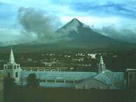
|
Mayon
volcano - Philippines |
INDONESIA Volcanoes activity VSI - PVMBG reports : Past events 2016-2017-2018-2019 and recent news 2022-2023 - 2024
Merapi volcano (Java) - PVMBG) reported that the eruption continued at Merapi on 24 September 2025 (local). Gas and vapor plume(s) rose to a maximum of 100 m (328 ft) above the vent. There were 6 hot rockfalls, traveling up to 2,000 m. There were 78 seismically detected rockfalls. The alert level remained at "Level 3 - Standby" (on a 4-level scale).PVMBG reported that the eruption at Merapi (on Java) continued during 21-27 March. Seismicity was at higher levels than the previous week. The SW lava dome produced 23 lava avalanches that traveled as far as 1.9 km SW down the Bebeng drainage, 20 that traveled as far as 2 km SW down the Krasak drainage, and 26 that traveled as far as 2 km W down the Sat/Putih drainage. Slight morphological changes to the SW lava dome resulted from minor collapses of material. The Alert Level remained at 3 (on a scale of 1-4), and the public was warned to stay 3-7 km away from the summit, based on location.As of the 30th of January 2025, the extrusive activity at the volcano continues at generally heightened levels. Local guide has been observing the volcano's behavior to provide first-hand information from the site during these days. On 28 January at 09:30 AM local time, a pyroclastic flow (hot avalanche of lava particles and ash) emanated from the southwestern lava dome through the southwestern flank of the volcano in the morning of 28 January. It resulted from a partial collapse of the growing active lava dome at the southwestern rim of the volcano's summit crater. Ash plumes were separated from the pyroclastic density current (so-called phoenix clouds). The public is being warned to stay at least 3 km away from the summit. Previous news 2024 - PVMBG reported the eruption at Merapi (on Java) continued during 18-24 December 2024. Seismicity remained high. Lava avalanches from the SW dome were observed 50 times and traveled as far as 1.7 km SW down the Bebeng and Krasak drainages. White emissions rose 25-150 m above the summit and drifted E and W, but weather often prevented observation. The Alert Level remained at 3 (on a scale of 1-4), and the public was warned to stay 3-7 km away from the summit, based on location.PVMBG reported that the eruption at Merapi continued during 21-27 June 2024. Seismicity had decreased compared to the previous week. The SW lava dome produced 86 lava avalanches that traveled as far as 2 km down the upper part of the Bebeng drainage on the SW flank. Morphological changes to the SW lava dome were due to continuing effusion and collapses of material. The Alert Level remained at 3 (on a scale of 1-4), and the public was warned to stay 3-7 km away from the summit, based on location.PVMBG reported that the eruption at Merapi (on Java) continued during 7-13 June 2024. Seismicity had decreased compared to the previous week. The SW lava dome produced 122 lava avalanches that traveled as far as 1.8 km down the upper part of the Bebeng drainage on the SW flank. Two pyroclastic flows descended the Bebeng, traveling as far as 1 km, at 2025 on 8 June and at 0406 on 9 June; the 8 June pyroclastic flow produced minor ashfall at the Merapi Observation Post in Kaliurang (8 km S). Morphological changes to the SW lava dome were due to continuing effusion and collapses of material. The volume of the SW dome was an estimated 2,265,200 cubic meters and the dome in the main crater was stable at an estimated 2,362,800 cubic meters based on a 13 June drone survey and webcam images. The highest temperature of the SW dome was around 245 degrees Celsius, two degrees higher than the 6 June measurement. The Alert Level remained at 3 (on a scale of 1-4), and the public was warned to stay 3-7 km away from the summit, based on location.As of the 31st of May 2024, the extrusive eruption at the volcano persists. On 31st of may, at around 05:31 local time early on morning, a hot avalanche, known as pyroclastic flow, detached from the active southwestern lava dome at the summit crater. A strong eruption occurred at the volcano on 4th of April 2024 in the morning. At about 06:28 local time, a large block-and-ash flow raced down through the Kali Boyong ravine on the southern flank. The pyroclastic flow created abundant grey ash plumes, known as phoenix clouds, a towering wall of ash separating from the pyroclastic flow as it tumbled down slope. From the available webcam images, hot avalanches were about to descend up to the edifice base, considering approx. 4 km from the summit. PVMBG reported that a strong eruption occurred at the volcano on 29th of January 2024 in the afternoon. At around 12:54 local time, a large hot avalanche, known as pyroclastic flow, descended from the active lava dome at the summit crater. The extremely dangerous, fast-moving turbulent flow consists of a mixture of hot rock fragments of the lava dome, volcanic gasses and ambient air. It traveled through the Kali Boyong ravine on the southern flank and reached the usual distance of about several hundred meters from the summit. It also produced massive grey ash-abundant plumes, so-called phoenix clouds, separating from the block-and-ash flow.As of the 25th of January 2024, the extrusive activity at the volcano continues at generally heightened levels. During these days a number of incandescent rockfalls, emanating from the southwestern lava dome, has been intensifying over the last night. Moreover, glowing lava blocks frequently detach from the viscous lava flow front, generating small avalanches as it descended the slope.At around 15:56 local time yesterday, a large hot avalanche, known as pyroclastic flow, descended from the active lava dome at the summit crater. It traveled through the southwestern Kali Bebeng ravine and reached a distance of estimated 1.8 km distance from the summit. It also produced massive grey ash-abundant plumes, so-called phoenix clouds, separating from the block-and-ash flow. A massive eruption occurred at the volcano on 21st of January 2024 shortly afternoon . At around 13:55 local time, a very large glowing avalanche, known as pyroclastic flow, descended from the active lava dome at the summit crater. The extremely dangerous, fast-moving turbulent flow consists of a mixture of hot rock fragments of the lava dome, volcanic gasses and ambient air. It traveled through the Bebeng/Krasak ravine on the southeastern flank and reached a distance of estimated several km from the summit, meaning close to populated areas. It also produced massive ash plumes that affected much of the southern flank and caused panic in some villages.As of the 9th of January 2024, the extrusive eruption of the volcano persists at heightened levels. The active southwestern and southeastern lava domes continue to grow as viscous magma rises into and pilling up there. Unstable, loose lava material makes both lava domes prone to partially collapse. Therefore, accumulated and large dome blocks tend to undergo gravity and turn into tumbling hot incandescent rock falls, emanating from the lava dome, and race over steep slopes down the edifice. Ash plumes and dust separating from block-and-ash flows, so-called phoenix clouds, accompany pyroclastic flows. Previous news 2023 - As of the 13th of December 2023, the extrusive activity at the volcano continues at generally heightened levels. About 150 incandescent rockfalls emanated from the southwestern lava dome that raced over the southern slope, reaching a length of at least 2500 meters from the summit yesterday. The glowing avalanches direction turned to south from southwest in previous days and might pose a threat to the community. Moreover, glowing lava blocks frequently detach from the viscous lava flow front, generating small avalanches as it descended the slope.As of the 4th of December 2023, a massive eruption occurred at the volcano late afternoon. At around 17:36 local time, a large hot avalanche, known as pyroclastic flow, descended from the active lava dome at the summit crater.As of 24th of September 2023,The extrusive eruption of the volcano persisted and remains at elevated levels in general. The active southwestern and southeastern lava domes continue to grow as viscous magma rises into and pilling up there. Unstable, loose lava material makes both lava domes prone to partially collapse. Therefore, accumulated and large dome blocks tend to undergo gravity and turn into tumbling hot glowing rock falls, racing over steep slopes down the edifice. Moreover, incandescent lava blocks detach from lava flow fronts and roll down to the base. Ash plumes and dust separating from block-and-ash flows, so-called phoenix clouds, accompany pyroclastic flows. As of the 27th of July 2023 The extrusive activity at the volcano continues at generally heightened levels. Observer reported that iIn the morning of 27 July, glowing lava blocks frequently detached from the viscous lava flow front, generating small avalanches as it descended the slope. About 35-40 incandescent rockfalls of lava material emanated from the lava dome at regular intervals of every 6 hours. Seismic recordings monitored 1 shallow and 1 hybrid earthquake. At 22:17 local time, several glowing avalanches were observed from the southern lava dome at intense levels. Lava dome volumes are estimated to be measured at approximately 1.7 million m3 (SW) and 2.6 million m3 (SE), respectively.As of the 24th of July, PVMBG reported that the heightened activity at the volcano continues. Near-frequent glowing dome-block avalanches tumble down from both, southwestern and southeastern lava domes onto the SW-SE ravines as viscous magma is being extruded towards the tops of the domes and shed incandescent rockfalls from there. Lava dome volumes are estimated to be measured at approximately 1.7 million m3 (SW) and 2.6 million m3 (SE), respectively.PVMBG reported that the eruption at Merapi (on Java) continued during 7-13 July 2023 and seismicity remained at elevated levels. The SW lava dome produced 152 lava avalanches that traveled as far as 2 km down the SW flank (upstream in the Boyong drainage), three that traveled as far as 800 m down the Boyong drainage, and one that traveled 1.2 km down the Sat/Putih drainage. Morphological changes to the SW lava dome were due to continuing collapses of material. The Alert Level remained at 3 (on a scale of 1-4), and the public was warned to stay 3-7 km away from the summit based on location.As of the 13th of July 2023, the eruption at the volcano continues at relatively intense levels. Maga rising to the summit crater accumulates as a dome that overspills the half-open summit crater to the southern and southeastern flanks, generating frequent incandescent avalanches and turbulent hot pyroclastic flows. In the past 24 hours, the volcano produced 16 avalanches that reached up to 1,800 m length on the southern slope, traveling mainly through the Bebeng river, according to a local newspaper citing information from the Centre for Volcanology and Geological Hazard Mitigation (PVMBG). As of the 2nd of July 2023, PVMBG reported that the extrusive activity at the volcano continues. The actively growing lava dome slowly grows and sheds numerous glowing avalanches that descend into the southwestern flank about a couple of km distance from the summit and lifted dust (so-called phoenix clouds) as can be seen in the attached video from last night. It resulted from a partial collapse of the lava dome at the southwestern rim of the volcano's summit crater.PVMBG reported that the eruption at Merapi (on Java) continued during 12-18 May 2023and seismicity remained at elevated levels. The SW lava dome produced 182 minor lava avalanches that traveled as far as 1.8 km down the SW flank (upstream in the Bebeng and Boyong drainages) and one that traveled 500 m NW (upstream of the Senowo River). Morphological changes to the SW lava dome due to continuing collapses of material were evident in webcam and drone images. The Alert Level remained at 3 (on a scale of 1-4), and the public was warned to stay 3-7 km away from the summit based on location.As of the 31st of March 2023,PVMBG reported that the intense activity of the volcano continues. Large glowing avalanches continue to be observed detaching from the southwestern lava dome at roughly frequent intervals of 5 to 10 minutes, Andi reported. A sliding distance usually has reached approx. 2 km length descending to the base of the edifice. .Therefore, risk of yet another dangerous, turbulent hot avalanche of lava rock fragments of all sizes embedded in a mixture of turbulent gas and ash racing down slopes remains high.As of the 26th of March 2023, PVMBG reported that the phase of the intense activity has been continuing over the past two weeks. Near-frequent glowing lava blocks continue to regularly detach from the southwestern lava dome and tumble down along the main sliding southwestern slope, descending to the base of the edifice and reaching approx. 2 km length. By today, the main sliding pathway has branched off into another sliding arm in the south direction as glowing rock falls roll down over it. From time to time, phoenix clouds are being formed - lifted ash plumes rising above pyroclastic torrent as descending the flank. As of the 19th of March 2023, PVMBG reported that the elevated activity of the volcano continues. Constant pyroclastic flows continue to travel from the southwestern lava dome as the active basaltic-andesitic lava intrudes into the dome. Therefore, more and more unstable lava material makes the dome prone to collapse towards the steep ravines, which in turn often develop into very dangerous block-and-flows.As of the 14th of march 2023 explosive activity continues. Volcanic Ash Advisory Center (VAAC) Darwin warned about a volcanic ash plume that rose up to estimated 15000 ft (4600 m) altitude or flight level 150 .As of the 12th of March 2023, PVMBG reported that pyroclastic flows continue to be triggered from the active southwestern lava dome area. On 12 March, a large-sized block-and-ash flow occurred, tumbling down over the western and southwestern flanks. Hot rock falls reached a quite considerable sliding distance of about 4-5 km from the summit. Volcanic ash might affect and appear in southwestern villages along Krasak and Bebeng rivers by covering most of the surfaces.As of the 11th of March 2023, PVMBG reported that a massive eruption occurred at the volcano shortly after noon. At around 12.15 p.m. local time, a very large glowing avalanche, known as pyroclastic flow, descended from the active lava dome at the summit crater. The extremely dangerous, fast-moving turbulent flow consists of a mixture of hot rock fragments of the lava dome, volcanic gasses and ambient air. It traveled through the Bebeng/Krasak ravine on the southeastern flank and reached a distance of estimated 7 km distance from the summit, meaning close to populated areas. It also produced massive ash plumes that affected much of the southern flank and caused panic in some villages. There are no reports of fatalities or injuries at the moment although information is yet incomplete from what might have happened in the areas hit by the flow. Pyroclastic flows are typically formed when the accumulated lava masses at the summit crater, known as the lava dome, become too large and suffer smaller or larger gravitational collapse, which then turn into fast and deadly avalanches as they destroy and burn everything in their path. PVMBG reported that the eruption at Merapi (on Java) continued during 24 February-2 March 2023and seismicity remained at high levels. The SW lava dome produced two lava avalanches that traveled as far as 1 km down the SW flank (upstream in the Bebeng and Boyong drainages). No significant morphological changes to the central and SW lava domes were evident in webcam images. The Alert Level remained at 3 (on a scale of 1-4), and the public was warned to stay 3-7 km away from the summit based on location.PVMBG reported that the eruption at Merapi (on Java) continued during 10-16 February 2023 and seismicity remained at high levels. The SW lava dome produced two lava avalanches that traveled as far as 1.7 km down the SW flank (upstream in the Kali Sat drainage). No significant morphological changes to the central and SW lava domes were evident in webcam images. The Alert Level remained at 3 (on a scale of 1-4), and the public was warned to stay 3-7 km away from the summit based on location.As of the 8th of February, PVMBG reported that a block-and-ash flow (hot avalanche of lava particles and ash) descended the southwestern flank of the volcano at 07:10 local time on the morning morning, reaching approx. 1500 m sliding distance from the summit. It resulted from growing, more and more unstable hot lava material, accumulating in the active lava dome at the southwestern rim, making it prone to collapse into hot rock falls. Ash plumes were separated from pyroclastic density currents (so-called phoenix clouds) that rose above the crater. The visibility of the event was very limited due to dense clouds.PVMBG reported that the eruption at Merapi continued during 12-19 January 2023 and seismicity remained at high levels. The SW lava dome produced three lava avalanches that traveled as far as 1.2 km down the SW flank (upstream in the Kali Bebeng drainage). Avalanche sounds were heard on six occasions. No significant morphological changes to the central and SW lava domes were evident in webcam images. The Alert Level remained at 3 (on a scale of 1-4), and the public was warned to stay 3-7 km away from the summit based on location. Previous news 2022 - PVMBG reported that the eruption at Merapi continued during 30 December 2022-5 January 2023 and seismicity remained at high levels. The SW lava dome produced eight lava avalanches that traveled as far as 1.5 km down the SW flank (upstream in the Kali Bebeng drainage). One pyroclastic flow descended 900 m SW. No significant morphological changes to the central and SW lava domes were evident in webcam images. The Alert Level remained at 3 (on a scale of 1-4), and the public was warned to stay 3-7 km away from the summit based on location. As of the 31st of December 2022, PVMBG reported that the extrusive activity at the volcano continues at intense levels. Visual field observations by a team reported many pyroclastic density currents occurring from the SW part of the active lava dome. Frequent glowing rockfalls have been seen tumbling down the SW slope sliding about 1 km from the summit. This time, the considerable reason for these pyroclastic flows has been heavy rains throughout the last night rather than the continuing fresh magma intrusion into the lava dome.BPPTKG reported that the eruption at Merapi continued during 9-15 November 2022. and seismicity remained at high levels. Cloudy often prevented clear visuals of the summit. A seismogram detected a pyroclastic flow at 0905 on 11 November that lasted 135 seconds; it descended 1 km down the Boyong drainage (SW), though webcam images were cloudy. A second pyroclastic flow occurred at 1208 on the same day, lasting 104 seconds and descending 1 km down the Boyong drainage (SW). On 12 November a lava avalanche traveled as far as 800 m down the SW flank. Two lava avalanches were observed descending the SW for 1.5 km on 15 November. The Alert Level remained at 3 (on a scale of 1-4), and the public was warned to stay 3-7 km away from the summit based on location.PVMBG reported that the eruption at Merapi continued during 28 October-3 November 2022 and seismicity remained at high levels. The SW lava dome produced lava avalanches that traveled as far as 1.2 km down the W flank (upstream in the Kali Sat drainage). No significant morphological changes to the central and SW lava domes were evident in drone photographs. The Alert Level remained at 3 (on a scale of 1-4), and the public was warned to stay 3-7 km away from the summit based on location.PVMBG reported that between October 21st and 27th, 2022, 14 lava avalanches were observed in the southwest, dominant up to the Bebeng River with a maximum slip distance of 1,500 m. The sound of the avalanches was heard from Babadan post 7 times with moderate intensity. No significant morphological changes were observed from the southwest dome and the central dome. The volume of the dome is fixed, namely for the southwest lava dome of 1,626,000 m³ and the central dome of 2,772,000 m³.PVMBG reported that from October 14th to 20th, 2022, five lava avalanches were observed towards the southwest at Merapi, dominant at S. Bebeng with a maximum slip distance of 1,800 m. The sound of the avalanches was heard from Babadan post 10 times with moderate intensity. No significant morphological changes were observed from the southwest dome and the central dome. The volume of the dome is fixed, namely for the southwest lava dome of 1,626,000 m³ and the central dome of 2,772,000 m³. PVMBG reported that from October 7th to 13th, 2022, 7 lava avalanches were observed at Southwest Merapi, dominant up to the Bebeng River with a maximum slip distance of 1,500 m. No significant morphological changes were observed from the southwest dome and the central dome. The volume of the dome is fixed, namely for the southwest lava dome of 1,626,000 m³ and the central dome of 2,772,000 m³. PVMBG reported that during the week from September 30th to October 6th, 2022, lava avalanches were observed 5 times southwestward at Merapi, dominating up to the Bebeng River with a maximum slip distance of 1,800 m and 1 time westward (upstream of Kali Putih) with a sliding distance of 800 m. The southwest dome and the middle dome still show growth, but no significant morphological changes have been observed. According to calculations from aerial photos with drones, the volume of the southwest lava dome is 1,626,000 m³ and the central dome is 2,772,000 m³. Mount Merapi's deformation that was monitored using EDM and GPS this week showed no significant changes. PVMBG reported that during the week from September 16th to 22nd, 2022, 13 lava avalanches were observed southwest of Merapi, dominant up to the Bebeng River with a maximum slip distance of 1,900 m.No significant morphological change was observed at the level of the domes. Based on photo analysis, the volume of the southwest lava dome is considered fixed at 1,624,000 m³ and the central dome is 2,772,000 m³.As of the 4th of September 2022, PVMBG reported that during te past week, 13 lava avalanches were observed, in a dominant southwest direction towards the Bebeng River with a maximum slip distance of 2,000 m. A growth of the southwest dome is observed, the volume of the dome is calculated at 1,624,000 m³. As for the central dome, it is estimated at 2,772,000 m³.As of the 29th of August, PVMBG reported that tThe behavior of Merapi has changed somewhat in recent days, with the increase in the number of hybrid earthquakes for a week and volcanic earthquakes for three days. PVMBG reported that during week from 18th to 25th of August 2022, 19 lava avalanches were observed on the southwest flank, dominant up to the Bebeng River with a maximum slip distance of 1,800m. No significant morphological changes were observed at the domes, apart from changes due to avalanches. During the week of August 12th to 18th , 2022, 23 lava avalanches were observed southwest of Merapi, dominant up to the Bebeng River with a maximum slip distance of 1,800 m. No southwestern dome growth was observed, while for the middle dome no significant morphological changes were observed. According to photo analysis, the volume of the southwest lava dome is 1,664,000 m³ and that of the central dome is 2,772,000 m³.PVMBG reported that the eruption at Merapi continued during 5-11 August 2022 and seismicity remained at high levels. As many as 43 lava avalanches traveled down the Bebeng drainage on the SW flank, reaching a maximum distance of 1.5 km. The Alert Level remained at 3 (on a scale of 1-4), and the public was warned to stay 3-7 km away from the summit based on location. The volcano was clearly visible on August 7th, 2022, until it was covered by fog. Observable fumaroles from the main crater were white, with low to moderate intensity about 20-30 meters from the summit.PVMBG reported that during the week of July 22th to 28th, 2022, the activity was marked by 47 lava avalanches towards the southwest, mainly to the Bebeng river, moving 1,800 m. max. Growth of the southwest and middle domes has resumed. The volume of the southwest lava dome is 1,672,000 m³ and that of the central dome is 2,796,000 m³. As of the 23rd of July, PVMBG reported that his week, 22 lava avalanches were observed in the southwest, dominant up to the Bebeng River with a maximum slip distance of 1,800 m. At the southwest dome, there is no change in the height of the dome. For the middle dome, no significant morphological change was observed. According to photo analysis, the volume of the southwest lava dome is 1,645,000 m³ and that of the central dome is 2,582,000 m³. PVMBG reported that between July 8 and July 14, 2022, 43 lava avalanches were observed southwest of the Merapi, dominant up to the Bebeng River with a maximum slip distance of 2,000 m. In the southwest dome, there is no change in the height of the dome. For the middle dome, no significant morphological change was observed. According to photo analysis, the volume of the southwest lava dome is 1,645,000 m³ and that of the central dome is 2,582,000 m³. As of the 14th of July 2022, PVMBG reported that the gas plume from the main crater, white, was observed with high intensity, about 50-75 meters from the summit.PVMBG reported that between July 1st and July 7th, 2022, 60 lava avalanches were observed at Merapi, in a dominant southwest direction towards the Bebeng River with a maximum slip distance of 2,000 m. At the southwest dome, growth is observed, and its volume is calculated at 1,645,000 m³. No change in the height of the cental dome was observed, so the volume calculated to remain at 2,582,000 m³.As of the 26th of June, PVMBG reported that during the weeki, 70 lava avalanches were observed mainly in the southwest, up to the Bebeng River with a maximum slip distance of 1,800 m. There is no change in the height of the dome. For the middle dome, no significant morphological change was observed. According to photo analysis, the volume of the southwest lava dome is 1,551,000 m³ and the central dome is 2,582,000 m³.PVMBG reported that during the week from June 10th to 16th, 2022, lava avalanches were observed 58 times southwestward at Merapi, dominating the Bebeng River with a maximum slip distance of 1,800 m. In the southwest dome, there is no change in the height of the dome. For the middle dome, no significant morphological change was observed. According to photo analysis, the volume of the southwest lava dome is 1,551,000 m³ and the central dome is 2,582,000 m³. PVMBG reported that during the week of June 3rd to 9th, 2022, the observatory reported 75 lava avalanches were observed in the southwest, dominant up to the Bebeng River with a maximum slip distance of 2,000 m. The southwest dome is not observed changes in the height of the dome. For the middle dome, no significant morphological change was observed. According to photo analysis, the volume of the southwest lava dome is 1,551,000 m³ and that of the central dome is 2,582,000 m³. The intensity of seismicity this week is still quite high. Mount Merapi's deformation, which was monitored using EDM this week, showed a distance shortening rate of 1.5 cm/day.PVMBG reported that from May 20th to 26th, 2022 This week, there were 3 collapse pyroclastic flows, falling towards the southwest (upstream of the Bebeng River) with a maximum slip distance of 2,000 m. Lava avalanches were observed 144 times towards the southwest, dominating the Bebeng River, with a maximum slip distance of 2,000 m. there is no change in the height of the southwest dome. For the middle dome, no significant morphological change was observed. According to photo analysis, the volume of the southwest lava dome is 1,551,000 m³ and that of the central dome is 2,582,000 m³. The intensity of seismicity this week is still quite high. Mount Merapi's deformation that was monitored using EDM this week showed a distance shortening rate of 0.6 cm/day. PVMBG reported that during week, from May 13th to 19th, 2022, there was 1 pyroclastic avalanche flow in the southwest (upstream of Kali Bebeng) with a sliding distance of 2,500 m. Lava avalanches were observed 82 times towards the southwest, dominating the Bebeng River, with a maximum slip distance of 2,000 m. According to the photo analysis, the volume of the southwest lava dome is 1,551,000 m³ and that of the central dome is 2,582,000 m³, without morphological changes.Mount Merapi's deformation, which was monitored using EDM this week, showed a distance shortening rate of 0.7 cm/day. As of the 12th of May, 2022, PVMBG reported that the extrusive activity of the volcano continues. A visible glow and gas, steam and a small amount of ash emissions from satellite image on 3 May show fresh viscous magma rising into the lava dome within the summit crater. Continuing magma accumulation into it made the lava dome prone to collapse resulting in a block-and-ash flow on 11th of May during the afternoon. The pyroclastic flow traveled over the southwestern slope reaching length of 1,800 meters from the summit.As of the 18th of April 2022, PVMBG reported that during past week, 112 lava avalanches were observed in a dominant southwest direction towards the Bebeng River with a maximum slip distance of 2,000 m. Aerial photos from drone surveys show two avalanche sources in the southwest dome, both pointing towards Kali Bebeng. Meanwhile, the source of the avalanches in the crater's central lava dome is in the old avalanche of March 9-10, 2022. The volume of the southwest lava dome is 1,672,000 m³ and the central dome is 2,582,000 m³. PVMBG reported no significant morphological changes at Merapi''s summit lava dome during 1-7 April 2022. Based on photo analyses, the volume of the SW lava dome was 1.7 million cubic meters while the central lava dome was 2.6 million cubic meters. Seismicity remained at high levels. As many as 144 lava avalanches originating from the SW dome traveled a maximum of 2 km down the Bebeng drainage on the SW flank. A single pyroclastic flow traveled 1.5 km down the SW flank. The Alert Level remained at 3 (on a scale of 1-4), and the public was warned to stay 3-5 km away from the summit based on location PVMBG reported that during the week of March 25th to 31st, 2022 at Merapi, there were 2 pyroclastic avalanche flows towards the southwest with a sliding distance of 2,500 m. Lava block avalanches were observed 118 times towards the southwest, dominating the Bebeng River with a maximum slip distance of 2,000 m. On the south-west dome we observe that the height increases by about 4 m. For the middle dome, no significant morphological change was observed. According to photo analysis, the volume of the southwest lava dome is 1,672,000 m³ and the central dome is 2,582,000 m³.Another pyroclastic flow occurred on April 1, 2022 at 3:00 p.m. WIB recorded on a seismogram with an amplitude of 35 mm and a duration of 94 seconds. Visually obscured by fog, it moved an estimated distance of 1,500 m to the southwest.PVMBG reported that during the week of March 18-24, 2022 here were 6 pyroclastic flows, with an estimated glide distance of 2,500 m. It was reported that there was light ash rain in Selo district. Avalanches of incandescent blocks were observed 51 times towards the southwest, dominating the Bebeng River, over a maximum sliding distance of 2,000 m. On the south-west dome we observe that the height increases by about 4 m. For the middle dome, no significant morphological change was observed. According to photo analysis, the volume of the southwest lava dome is 1,609,000 m³ and the central dome is 2,582,000 m³.PVMBG reported that during the week between Mar ch 11th and 17th, 2022, 119 lava avalanches were observed southwestward at Merapi, up to the Bebeng River with a maximum slip distance of 2,000 m and 4 times southeastward (in upstream of the Gendol river) with a maximum sliding distance of 1,000 m. Morphological analysis shows a decrease in height of the southwest dome of approximately 2 m due to avalanche activity. The middle lava dome did not observe significant morphological changes. According to the analysis of the photos, the volume of the southwest lava dome: 1,546,000 m³ and of the central dome: 2,582,000 m³. PVMBG reported that on March 9 and 10, 2022, the Merapi triggered 17 pyroclastic avalanche flows (APG) towards Kali Gendol. issued from the southeast side of the Kaliadem bunker. Based on aerial photography using drones, the distance for the APG t was about 4.9 km from the summit.The Merapi hot clouds of March 10, 2022 at 01:00, 01:22, 01:35, 01:59, 02:07 WIB were recorded on a seismogram with a max amplitude of 75 mm and a max duration of 191 seconds. Maximum glide distance of ± 2,000 m to the southeast. Between 6:00 p.m. and 10:00 p.m. WIB, activity is dominated by avalanche earthquakes. Occasional incandescent lava avalanches are observed to the southeast and southwest. PVMBG reported that an avalanche pyroclastic flow was recorded at Merapi on March 7, 2022 at 8:39 p.m. WIB on a seismogram with an amplitude of 34 mm and a duration of 158 seconds. The glide distance is 2,000 m to the southwest.PVMBG reported that activity is still quite high in the form of effusive eruption activity. This week from February 25 to March 3, 2022, lava avalanches were observed 73 times to the southwest, dominating the Bebeng River with a maximum slip distance of 2,000 m.Morphological analysis showed that there were morphological changes in the southwest lava dome as avalanches, but no significant elevation changes were observed. For the central dome, no change was observed. Merapi, one of Indonesia's most active volcanoes, lies in one of the world's most densely populated areas and dominates the landscape immediately N of the major city of Yogyakarta. The steep-sided modern Merapi edifice, its upper part unvegetated due to frequent eruptive activity, was constructed to the SW of an arcuate scarp cutting the eroded older Batulawang volcano. Pyroclastic flows and lahars accompanying growth and collapse of the steep-sided active summit lava dome have devastated cultivated and inhabited lands on the volcano's western-to-southern flanks and caused many fatalities during historical time. The volcano is the object of extensive monitoring efforts by the Merapi Volcano Observatory (MVO).
Awu volcano (Sangihe islandsi) - PVMBG reported that an increase in both deep and shallow volcanic
earthquakes at Awu were recorded on 22 March 2024 and again during 10-15 April.
Tiltmeter data from two stations recorded inflation during 1 March-16
April. The Alert Level was raised to 3 (on a scale of 1-4) at 1800 on 16
April and the public was warned to stay at least 5 km away from the
crater's center. PVMBG noted that elevated seismicity had been occurring
periodically since July 2023. Previous news 2023 - PVMBG volcano observatory reported that an increased seismic activity has been registered.
During 12-25 July 2023, a relatively high number of shallow (129) and deep (95) earthquakes, including an elevated seismic energy has been detected in the RSAM graph. However, no low-period/low-frequency earthquakes nor tremor vibrations have been identified yet so far, a typical sign for an impending eruption. During the observation period, the surveillance camera observed a minor degassing activity from the crater area. Gas emissions rose 10-100 meters above the summit.
The potential hazards of the volcano represent sudden explosive/phreatic eruptions and/or pyroclastic flows due to lava dome gravitational/explosive collapse, effusive eruptions producing viscous lava flows. Another hazard poses significant pollution from volcanic gases (CO, CO2, H2S, N2 and CH4) that might be life-threatening if they exceed a certain threshold safety value. Therefore, people are advised to avoid the area of the volcano within a 3 km radius from the crater. Previous news 2022 - Photos of Gunung Api Awu, Sangihe / Sulawesi revealed the presence on September 6th, 2022 of a lava dome, emitting several fumaroles. As of the 12th of May 2022, PVMBG reported that The Volcanic Alert Level of the volcano was raised from Level 2 (valid from 12 December 2021) to Level 3, as an increase of volcanic earthquakes has been registered over the past three days.
Quakes started to be more frequent on 9 May, of which 88 have been located at shallow levels. Earthquakes have continued to pick up in numbers and became shallower on the next day as the seismic network detected 90 shallow quakes which may indicate elevated fluid movements of gas, water and possibly magma under the surface fracturing the rock.
On 11 May at 15:00 local time, emissions of gas and steam were observed rising about 30 meters above the crater.
The warning bulletin states that ballistic impacts of volcanic bombs, pyroclastic flows and/or likelihood of significant phreatic eruption could affect an area of about 3,5 km distance from the crater. The massive Gunung Awu stratovolcano occupies the
northern end of Great Sangihe Island, the largest of the Sangihe arc. Deep
valleys that form passageways for lahars dissect the flanks of the volcano,
which was constructed within a 4.5-km-wide caldera. Powerful explosive
eruptions in 1711, 1812, 1856, 1892, and 1966 produced devastating
pyroclastic flows and lahars that caused more than 8000 cumulative
fatalities. Awu contained a summit crater lake that was 1 km wide and 172 m
deep in 1922, but was largely ejected during the 1966 eruption. (GVN/GVP)
Agung volcano (Bali) -As of the 4th of April 2022 Based on ground reports, satellite imagery, and wind model data, the Darwin
VAAC reported that during 3 April an ash plume from Agung rose to 3.7 km
(12,000 ft) a.s.l. The Alert Level remained at 1 (on a scale of 1-4). Previous news 2020 - The period from January 1, 2020 to July 16, 2020 was dominated by a plume emanating from the white crater, of low intensity with a height of about 20-150 meters above the summit. The last eruption occurred on June 13, 2019 at 1:38 a.m. WITA and the surface activity is now dominated by gusts of low to moderate intensity. PVMBG reported reported, for February 10th, 2020 , a blast earthquake with an amplitude of 1.5 mm, for 35 sec. And a local tectonic earthquake with an amplitude of 3 mm. The top lava cake was hemmed with white fumaroles visible on the webcam images. As of the 5th of February 2020 , PVMBG reported that many fumaroles rose above the dome-pancake present in the summit crater. A small white plume about 50 meters high surmounted the summit. The level of activity remains at III / siaga, with a 4 km radius danger zone around the crater and advice on drainage where secondary lahars can form following seasonal rains. Previous news 2019 - PVMBG reported that a new eruptive episode occurred on June 13th 2019 at 01h38 local, recorded on a seismogram with a maximum amplitude of 30 mm and for 3 minutes 53 seconds.The height of the eruptive column could not be observed due to fog. Incandescent materials were ejected in all directions for a distance of about 700 meters, and their glow still observable 10 minutes after the eruption. Deposition of ash and lapilli is observed in the rain in the Besakih region. PVMBG reported that a new eruption occurred on June 10, 2019 at 1212 WITA, with ash column height observed at ± 1000 m above the summit (± 4 142 m above sea level). of the sea). The column of ash is gray, of moderate intensity, inclined to the east and south-east. This eruption is recorded on a seismogram with a maximum amplitude of 24 mm and a duration of ± 1 minute..PVMBG reported that a new eruption took place on May 31, 2019 at 11:42 am WITA. The height of the ash column was observed at ± 2000 m above the summit (± 5 142 m above sea level). The column of ash was gray, thick in intensity and inclined to the northeast and east. This eruption is recorded on a seismogram of maximum amplitude of 30 mm and a duration of ± 8 minutes 4 seconds.PVMBG reported that on May 24, 2019 at 19:23, the height of the ash column being observed at ± 2500 m above the summit (± 5 642 m above sea level). The column of ash was gray and thick, bending west and southwest. This eruption is recorded on a seismogram of maximum amplitude of 30 mm (off scale) and a duration of ± 4 minutes 30 seconds.PVMBG reported that a new eruptive episode occurred on May 18, 2019 at 02:09 WITA at the Agung volcano , accompanied by a plume of ash, gray and thick, about 2,000 meters above the summit the dissipated to the east and north, with no influence on air traffic.The activity level remains at 3 / siaga with a 4 km risk zone around the crater. An eruption occurred on May 12, 2019 at 22:29 Wita, characterized by a dull sound heard at the Rendang post, a glow at the top and incandescence on the flanks.The height of the plume could not be determined due to cloud cover.On the seismogram, the activity remained marked for 2 minutes 16 sec., With a max. 25 mm. PVMBG reported that an event at Agung was recorded by the seismic network at 1859 on 3 May 2019. An ash plume was not visible from the Agung Volcano Observatory in Rendang (about 8 km SW), although the Darwin VAAC report a growing thermal anomaly and possible ash near the summit. About 30 minutes later the VAAC reported that an ash plume rose to 4.3 km (14,000 ft) a.s.l. and drifted NE; a thermal anomaly continued to be visible. On 6 May at 2255 a gray ash plume rose to around 2 km above the crater rim and drifted W. The Alert Level remained at 3 (on a scale of 1-4) with the exclusion zone set at a 4-km radius.PVMBG reported that a new eruptive episode occurred on April 30th, 2019 at 5:34 WITA. It was recorded for 2 minutes 15 sec., with a max amplitude of 25 mm. An ash plume, gray and thick, was observed 1,000 meters above the summit. Ash falls are reported on the surrounding villages.PVMBG reported two explosive eruptions at Agung on 21 April: the first was
recorded at 0321 and produced a dense gray ash plume that rose 2 km above
the crater rim and drifted W and S. Ashfall was reported in areas downwind
including Besakih (7 km SW), Rendang (12 km NW), Klungkung (~40 km S),
Gianyar (20 km WSW), Bangli (17 km WNW), Tabanan (51 km WSW), and the
International Gusti Ngurah Rai (IGNR) airport (60 km SW) in Denpasar. The
second event was recorded at 1856 and generated a dense ash plume that rose
3 km and drifted S. Minor ashfall was reported in Besakih, Rendang, Sebudi
(6 km SW), and Selat (12 km SSW). The eruptions were accompanied by a boom
heard at both the Rendang and Batulompeh observation posts. Ejected
incandescent material from the two events fell on the flanks in all
directions within a radius of 4 km. The Alert Level remained at 3 (on a
scale of 1-4) with the exclusion zone set at a 4-km radius. PVMBG reported that a new eruptive episode occurred on 11 April 2019 at 18:47 local accompanied by a gray and thick ash plume, observed at about 2,000 meters above the summit, leaning to the west. The plot on the seismogram, with a maximum amplitude of 25 mm, lasted 2 minutes 8 seconds.PVMBG reported that a new eruption occurred on April 4, 2019 at 01:31 WITA, accompanied by a column of ash observed at ± 2,000 m above the summit (± 5,142 m above sea level). The column of ash was gray, of a thick intensity, bending towards the west. This eruption is recorded on a seismogram of maximum amplitude of 25 mm and a duration of ± 3 minutes 37 seconds. A roaring roar was heard as far as Rendang Station.PVMBG reportede that a new eruptive episode occurred on March 28th, 2019 at 6:25 pm. A loud noise was heard until Amed and a black ash plume observed rising to about 5,400 meters, partly obscured by clouds. Ash falls are reported from surrounding villages.On the seismogram, the eruption amplitude measured was of 25 mm for a duration of 2 min. 32 sec.The alert level remains at 3 / siaga, with an orange VONA. PVMBG reported that a new eruptive episode on March 21, 2019 at 0:18 WITA, recorded on the seismogram with a maximum amplitude of 23 mm and a duration of 1min. 47 sec.The height of the plume could not be observed, due to top cover.The volcano remains on alert level 3 / Siaga, with a danger zone of 4 km radius.PVMBG reported that at 1827 on 15 March an explosive event at Agung was
recorded for one minute and 23 seconds and produced a dense gray ash plume
that rose about 1 km above the crater rim and drifted NNW. Minor ashfall
was reported in the villages of Kubu (6 km N), Tianyar (14 km NNW), Ban,
Kadundung, and Sukadana. At 0803 on 17 March an event was recorded for 39
seconds and produced a dense gray ash plume that rose about 500 m above the
crater rim and drifted E. A second event began at 1030 and lasted about one
minute and 16 seconds; a dense gray ash plume rose about 600 m and drifted
E. At 0736 on 18 March an ash plume rose 1 km and drifted W and NW. Thermal
satellite images continue to indicate hot areas in the crater on the
previously-erupted lava surface especially near the flow margins. The Alert
Level remained at 3 (on a scale of 1-4) with the exclusion zone set at a
4-km radius. PVMBG reported that an eruption occurred on March 15, 2019 at 18:27 WITA at Agung, on Bali Island; a column of gray ash rose about 1,000 meters above the summit, bending westward.On the seismogram, it was recorded with a max. 23 mm during 1 minute 23 seconds.The level 3 / siaga remains in force, with a danger zone of 4 km radius and increased vigilance in drainages. The VONA is orange. PVMBG reported that at 0452 on 4 March 2019 an event at Agung was recorded for
just under three minutes and produced ashfall in Besakih (7 km SW) around
0615. No ash plume was visible although foggy conditions prevented views of
the summit. An event that began at 0047 on 9 March lasted for 3 minutes and
50 seconds, and produced an ash plume that drifted E. The Alert Level
remained at 3 (on a scale of 1-4) with the exclusion zone set at a 4-km
radius.
PVMBG reported that on February 22 at 16:31 WITA an eruptive episode occurred accompanied by a gray plume rose to 300 - 700 meters above the summit, inclined to the East. On the seismogram, it lasted 6 min. 20 sec. with a maximum amplitude of 11 mm. For the day of 22.02.2019, the PVMBG reports 2 eruption earthquakes, 4 breath earthquakes, and one episode of harmonic tremor. The activity level remains at 3 / siaga. PVMBG reported that an eruption occurred in Agung, on the island of Bali, on 14th February 2019 at 4:34 WITA. The height of the plume could not be determined, and small fallout of ashes are reported in several villages near the volcano.PVMBG reported that on January 21st, a first eruption of 16:45 WITA was recorded on the seismogram with a max. 22 mm and a duration of 1 min. 52 sec. A second eruption occurred at 17h WITA was with an amplitude of 23 mm and a duration of 1 min. 17 sec.In both cases, the ash plume could not be observed due to fog. On January 22, at 3:42 local time, another eruption was accompanied by a plume of ash 2,000 meters above the crater.The activity level remains at 3 / siaga.PVMBG reported that a small eruption occurred on January 19, 2019 at 2:45 local time; the amplitude on the seismogram was 23 mm and the duration was 128 sec. A plume 700 meters rose above the crater could be observed, as well as the projection of incandescent materials on the upper east flank, with a range of up to 1,000 meters from the edge of the crater.The activity level remains at 3 / Siaga. PVMBG reported that an eruption occurred on January 10, 2019 at 7:55 PM at Agung, on the island of Bali. The height of the plume could not be estimated due to fog. It is announced up to 6,000 meters to NNW by VAAC Darwin.On the seismogram, the recording has a maximum amplitude of 22 mm and a duration of about 4 minutes 26 seconds. According to information obtained by Bali Express, a number of residents of Bal. The latest image of the Sentinel 2 satellite, dated January 8, showed various hot spots on the slab in the crater; a very slight thermal anomaly of 1MW was recorded by Mirova on January 10 at 6:10 PM The PVMBG maintains the level of activity at 3 / siaga, with a 4 km radius danger zone around the crater and recommendations not to park in the drainages, where a lahar possibility exists. Ash rains occurred in the Desa Ban area of Kubu district, as far as Terunyan village, Kintamani district, Bangli. PVMBG reported that on December 30 at 04:09 WITA; un explosive event occurred with duration 3 minutes 8 sec., with an amplitude of 22 mm on the seismogram. The eruption is due to an "overpressure" due to the accumulation of volcanic gases. At the time of the eruption, an incandescence was observed at the top, but the height of the ash column was not observed due to the fog. According to satellite information, the volcanic ash is moving towards the southeast, reaching 5,500 m altitude. An orange aviation code has been established by VAAC Darwin.Light ash rains were reported in the Karangasem regency, in the southeastern sector of Mount Agung, as in the city of Amlapura and in several villages including Seraya Barat, Seraya Tengah and Tenggalinggah. As of the 22nd of August, according to the Darwin VAAC, a webcam recorded a diffuse ash emission from
Agung rising to an altitude of 3.3 km (11,000 ft) a.s.l. and drifting W.
The Alert Level remained at 3 (on a scale of 1-4) and the exclusion zone
was stable at a 4-km radius.
PVMBG reported that white plumes rose 100-300 m above Agung's crater rim
during 1 and 2-7 August. The Alert Level remained at 3 (on a scale of 1-4)
with the exclusion zone set at a 4-km radius.
According to PVMBG a ground-based observer reported that at 0041 on 25 July
an event at Agung produced a dense ash-and-gas plume that rose 700 m and
drifted E and SE. Seismic data recorded the event for two minutes and 15
seconds. At 1406 on 27 July an event lasting one minute and 32 seconds
produced a dense ash-and-gas plume that rose 2 km and drifted W. The Alert
Level remained at 3 (on a scale of 1-4) and the exclusion zone was stable
at a 4-km radius.
PVMBG reported that an explosion occurred on July 24 at 12:52 WITA; it lasted 2 minutes and 13 seconds, and was accompanied by a plume of ash rising to 1,500 meters above the crater, before drifting to the southeast.Seismicity is characterized by low frequency earthquakes.The alert level remains at III / Siaga, with an orange VONA. PVBMG reported that two explosion occurred on 15th of July; the first eruptive episode occurred this 15.07.2018 at 04:52 WITA and lasted 2 min.20 sec. The plume could not be observed.- the second lasted 1min.45 sec., and was accompanied by a plume of ash rising to 1,500 meters. The BNPB reports ash falls in various villages: Bhuana Giri, Pidpid, Nawa Kerti, Datah Ababi, Abang Kertha Mandala and Amlapura.Bali Airport operates normally. The VONA is orange.The seismicity of July 15th, between 0h and 18h, is characterized by 1 eruption earthquake, 3 blast earthquakes, 4 superficial volcanic earthquakes, and 1 deep, and 1 distant tectonic earthquake.The PVMBG reports a new strombolian eruption on July 8 at 4:22 am WIB.It was followed at 10 am local time by an ash emission, following an eruption of a duration of 150 sec., with a record of an amplitude of 24 mm on the seismogram.New ash emission at 16:00 local time.They noted that 4,415
evacuees were housed in 54 evacuation centers. An ash plume rose from the
crater at 1120 on 9 July and drifted W. The Alert Level remained at 3 (on a
scale of 1-4) and the exclusion zone was stable at a 4-km radius.
PVBMG reported that on July 6 in the early evening, around 19:21, incandescence coud be observed at the top, accompanied with small black plume. An event at 0413 on 3 July generated an ash plume that rose
around 2 km. The Alert Level remained at 3 (on a scale of 1-4) and the
exclusion zone was stable at a 4-km radius.
PVMBG reported that during night Monday 2nd of July around 9 pm a new explosive activity occurred characterized by ejection of the hot rocks. The event was heard ad felt around East Bali, leading evacuations of 28 villages around the volcano. An ash column rose to 2000 m high above the summit crater and quickly disperded. PVMBG reported that eruptive activity on the evening of June 30 was characterized by incandescence indicating the presence of fresh lava in the crater. On 1st of July around 1:51 WITA, a white degassing rose above the crater of 1,500 meters, before drifting to the west.The alert level remains at 3, with an orange VONA. All airports operate normally. Lava continued to effuse, and by 1 July the estimated volume of new lava
was 4-5 million cubic meters making the total volume erupted since 21
November 2017 around 27-28 million cubic meters (50% of the total crater
volume). The height difference between the lowest part of the crater rim
(SW side) and the highest part of the lava surface (in the center of the
crater) was 85-90 m. PVMBG reported that on June 27 at 22h21 local an ash emission formed a thick plume observed at about 2,000 meters above the summit (5,142 meters asl), before drifting westward.Seismicity is dominated by volcanic earthquakes and harmonic tremors.On June 28, there is still a small gray-white plume rising 500 meters above the summit.The alert level remains unchanged, with a prohibited area of 4 km radius.PVMBG reported that at 1105 on 13 June an event at Agung produced a dense
ash plume that rose around 2 km above the crater rim and drifted SW and W.
Based on analysis of the seismic data, the event lasted two minutes and 12
seconds. Another event was detected at 2115 on 15 June, though foggy
conditions prevented estimations of the ash plume height; ash fell in areas
W, including in Puregai (7 km W). The Alert Level remained at 3 (on a scale
of 1-4) and the 4-km-radius exclusion zone was unchanged.
PVMBG reported that an explosion accompanied by an ash plume was recorded on 10 June at 22:14 local.The plume, which dissipated to the west, could not be observed due to fog.In general, tiltmeter and GPS showed long-term deflation since
December 2017, though inflation began to be detected the second week of
May; deformation analysis indicated that magma continued to accumulate
about 3-4 km below the crater. Low- and high-frequency earthquakes also
suggested rising magma. Sulfur dioxide flux was 190-203 ons/day, and
thermal anomalies in the crater were identified in satellite data. The
erupted volume of lava was estimated to be 23 million cubic meters,
equivalent to about a third of the total crater volume. The maximum amplitude on the seismogram is 22 mm and the duration of the episode of 1 minute 58 sec.PVMBG reported that although there were some periods of foggy conditions
during 23-29 May, white plumes were occasionally observed rising as high as
400 m above Agung's crater rim. At 0539 on 29 May an event generated an ash
plume that rose 500 m above the crater rim and drifted SW. The Alert Level
remained at 3 (on a scale of 1-4) and the exclusion zone continued at a
4-km radius.
PVMBG reported that at 1719 on 19 May an event at Agung generated an ash
plume that rose 1 km above the crater rim and drifted SE. The Alert Level
remained at 3 (on a scale of 1-4) and the exclusion zone continued at a
4-km radius. An explosive event occurred on 30th of April 2018 at 22:45 local. A plume of ash and gas rose 1,500 meters above the summit. PVMBG reported that although there were often foggy conditions during 18-24
April, white plumes were observed rising as high as 300 m above Agung's
crater rim and drifting E. The Alert Level remained at 3 (on a scale of
1-4) and the exclusion zone continued at a 4-km radius.
Based on webcam views, satellite data, and ground-based observations, the
Darwin VAAC reported that on 11 April an event at Agung generated an ash
plume that rose to an altitude of 3.7 km (12,000 ft) a.s.l. and drifted SW.
PVMBG reported that an event at Agung at 1737 on 5 April generated an ash
plume that rose 500 m above the crater rim and drifted W. Seismicity was
dominated by high- and low-frequency earthquakes. The Alert Level remained
at 3 (on a scale of 1-4) and the exclusion zone continued at a 4-km radius.
PVMBG reported that at 1009 on 26 March 2018 an event at Agung
generated an ash plume that rose at least to an altitude of 3.6 km (11,650 ft) a.s.l. and drifted NW. The Alert Level remained at 3 (on a scale of
1-4) and the exclusion zone continued at a 4-km radius.
PVMBG reported that although there were sometimes foggy conditions during
7-13 March , white plumes were observed rising as high as 600 m above
Agung's crater rim and drifting E. An event at 2332 on 11 March generated
an ash plume that rose about 950 m and drifted E. The Alert Level remained
at 3 (on a scale of 1-4) and the exclusion zone continued at a 4-km radius. PVMBG reported that on 28 February gray-white plumes rose as high as 300 m
above Agung's crater rim. During 1-5 March white plumes rose as high as 500
m above the crater rim. The Alert Level remained at 4 (on a scale of 1-4)
with an exclusion zone set at a 6-km radius. As of the 13th of February, PVMBG reported that during the past month, the frequency of eruptive incidents has decreased according to the observations, the last eruption is reported by the observatory on January 24, 2018.The volume of the lava dome has not changed significantly, and is still estimated at 20 million cubic meters, or 1/3 of the empty volume of the crater.Inflation is still observed, but characterized by a lower ratio, indicating that pressurization following magmatic movements is less significant. On February 12, the seismicity was characterized by 7 emission earthquakes, an episode of harmonic tremor, 5 superficial volcanic earthquakes VB, 7 deep volcanic earthquakes VA and a tectonic earthquake.On February 13 at 11:49 local, a plume of ash and gas was observed at 1,500 meters above the summit. On Saturday, February 10 at 9 am WITA, the authorities announced at the Rendang Observation Station that the status of the Agung was downgraded from level IV to level III.The radius of the risk zone has been reduced from 6 to 4 km; all refugees can return home, repatriation measures being taken. PVMBG reported that white-and-gray plumes rose as high as 1 km above
Agung's crater rim during 24-25 January. Foggy conditions prevented visual
observations of the crater during 26-30 January. The Alert Level remained
at 4 (on a scale of 1-4) and the exclusion zone continued at a 6-km radius.
PVMBG reported that at 1920 on 19
January a Strombolian event produced an ash plume that rose as high as 2.5
km and drifted E, and ejected incandescent material as far as 1 km from the
crater. Incandescence emanated from the crater for about two hours after
the event. White-to-gray plumes rose 500 m during 22-23 January. The Alert
Level remained at 4 (on a scale of 1-4) and the exclusion zone continued at
a 6-km radius.
. PVMBG reported that an eruption occurred this January 15 at 7:23 WITA; it was accompanied by a plume of gray ash rising to about 2,000 meters. A fine shower of ashes fell on Kesimpar.The alert status remains at maximum level and Ngurah Rai airport is operating normally. PVMBG reported that following the high ash emission of January 11 at 17:54 WITA and a plume at 2,500 meters, those of January 12 was less intense and was maintained at a height around 500 meters. The night glow was not perceived. PVMBG reported that during 3-9 January gray-and-white plumes rose as high
as 2 km above the crater rim and drifted in multiple directions. The Alert
Level remained at 4 (on a scale of 1-4).
PVMBG reported that during 27 December 2017-2 January 2018 gray-and-white
plumes rose as high as 2 km above Agung's crater rim and drifted W, SW, and
E. Incandescence from the crater was often observed at night. Ash fell in
several local villages including Badeg, Yeha, Temukus, Besakih (11 km WSW),
and Muncan (12 km SW) on 1 January, and Rendang post on 2 January. The
Alert Level remained at 4 (on a scale of 1-4), and the exclusion zones
continued at a general 8-km radius and 10 km in the NNE, SE, S, and SW
directions.
PVMBG reported that during 20-26 December gray-and-white plumes rose as
high as 2 km above Agung's crater rim and drifted W and E; weather clouds
and fog sometimes prevented visual observations. Incandescence from the
crater was sometimes observed at night. BNPB reported that during 22-23
December events generated dense gray ash plumes that rose as
high as 2.5 km above the crater rim and drifted NE. Ash fell on the flanks
and in Tulamben, Kubu. As of 25 December there were 71,045 evacuees spread
out in 239 shelters. The Alert Level remained at 4 (on a scale of 1-4), and
the exclusion zones continued at a general 8-km radius and 10 km in the NNE, SE, S, and SW directions. PVMBG reported that during 13-19 December gray-and-white plumes rose as
high as 2.5 km above Agung's crater rim and drifted W, N, and E; weather
clouds and fog sometimes prevented visual observations. Incandescence from
the crater was sometimes observed at night. The Alert Level remained at 4
(on a scale of 1-4), and the exclusion zones continued at a general 8-km
radius and 10 km in the NNE, SE, S, and SW directions.PVMBG posted two map-view images of Agung, one from 20 October showing
pre-eruptive conditions and one from 16 December showing the lava that had
erupted onto the crater floor, noting that about 1/3 of the crater had been
filled with an estimated 20 million cubic meters of lava. The number of evacuees on 10 December was 70,079
(spread out in 237 shelters). Ash plumes rose as high as 2 km. Lahars were
observed in a drainage originating on the flanks of Agung. An explosion at
0549 on 11 December generated a dense ash plume that rose 2.5 km and
drifted W and NW. Multiple ash-plume events were observed during 11-12
December, with plumes rising 1.5 km above the crater rim. Video taken at the summit crater. on 13th of December. An overflight by drone, carried out on December 14 showed the "lava cake"in the summit crater.The PVMBG states that the ratio of magma emitted has decreased since the end of November, and only 1/3 of the crater is filled with lava. The Alert Level
remained at 4 (on a scale of 1-4), and the exclusion zones continued at a
general 8-km radius and 10 km in the NNE, SE, S, and SW directions. BNPB reported that on December 9, plumes of ashes were observed at 5:05 and 5:49 local; strong winds tilted the plume north. A local 7h30 eruption ejected ash and gas to 2,000 meters above the crater. ashfall was reported on the village of Temakung / Karangasem. As of the 8th of December, some ash emissions reaching a height between 500 and 2,100 meters above the summit; glowing was observed during the night. BNPB reported that a gray-white plume rose to 500-1,000 meters above the crater, then drifted eastward on December 4 at 23:15 WITA. during nighttime glowing was observed above the crater.
The seismicity was characterized by 4 deep volcanic earthquakes VA, 14 superficial volcanic earthquakes VB, 29 low frequency earthquakes and 2 harmonic tremor episode.
The level of the tremor is of 1-2mm of amplitude, with a dominant at 1 mm.
According to BNPB, the volcano seems calm on the morning of December 3, emitting only a plume of steam and gas at 500-1,000 meters above the crater. However,, the internal activity remained important. Yesterday, a continuous tremor of 22 minutes between 14:34 and 14:56 local were recorded indicates, according to the PVMBG, a supplied of magma still occurs, and predicts a lapse of time of ten days for the filling of the crater, a total volume estimated at 60,000,000 m³.Seismicity remains low overall, and the level of alert identical. In the day of November 29, a gray plume was seen at a height of 1,500-2,000 meters above the crater; the 17:25 WITA eruption and plume height could not be observed because of the fog covering the summit.The thermal anomaly observed at Agung in recent days has been several times: 27.11 with 51 MW, 28.11 at 22:20 WITA with 97 MW, 29.11 with 5 MW, attesting to magmatic activity, and risks of ejection of incandescent ballistic projectiles and ashes, at first, production of lava flows and pyroclastic flows, or more in case of plinian eruption.As for the inconvenience due to ashes on the air traffic, the airport of Bali is opened, this November 30, while that of Lombok was closed again.
The seismicity is relatively low, with 9 VA deep volcanic earthquakes, 23 VB superficial volcanic earthquakes, a local tectonic earthquake, an eruption earthquake, and a continuous tremor of amplitude varying between 1 and 24 mm (with a dominant at 2 mm) ; On November 30, the tremor level decreased with a dominant at 1 mm.As of the 28th of November, BNPB reported that magmatic eruption continued. The ash plume oscillates between 2,500 and 4,000 meters above the summit, before drifting to the southwest.
On November 27, the MIROVA site detected for the first time a thermal anomaly of 51 MW, indicating the presence of lava on the surface. Tremor, of amplitude 1 to 2 mm (dominant 1 mm) is recorded continuously, and reported increasing 28.11.Heavy rains increase the risk of lahars and landslides. The mudslides and lahars in progress have so far been no casualties. 22 villages are present in zone of danger (8-10 km around the volcano), and the number of people living there is estimated between 90,000 and 100,000.
This particular situation has a direct impact on air traffic: the authorities extended the closure of Ngurah Rai International Airport until 29 November at 7am. As of the 27th of November, BNPB reported that based on the analysis of the instrumental and visual data, and the consideration of potential dangers, the alert level of the Agung has reached the maximum: level IV / Awas.The exclusion zone has been extended to a radius of 8 km, and to 10 km at NNE and SSO of the crater. These areas are permantly evaluated; they include the villages of Ban, Dukuh, Baturinggit, Sukadana, Kubu, Tulamben, Datah, Nawakerti, Pidpid, Buanagiri, Bebandem, Jungutan, North Duda, Amerta Buana, Sebudi, Besakih and Pempatan.The airport Ngurah Rai was closed initially until 28.11 in the morning, because of the ashes.Following the rains, a first lahar was observed south of Agung in Sidemen district. It is advisable not to have activity around the river. The ashes fell in many places, covering the roofs and plants with thick ash layer; they are reported from the villages of North Duda, Duda Timur, Pempetan, Besakih, Sideman, Tirta Abang, Sebudi, Amerta Bhuana in the Klungkung District, and some villages in Gianyar.According latest news, the activity of the Agung has changed during the night, and on November 26 in the morning, a large ash plume rose from a height of 2,000 meters above the summit at 5:05 WITA to 3,000 meters at 5:45 am. Gome-2 satellite detected the sulfur dioxide emitted by the eruption; this morning at 9:30 local, the flow of SO2 was estimated at 1,000-2,000 tons, a value qualified with certainty of magmatic.
The BNPB also reported that the eruptions have a magmatic character since last night.
The VONA for Agung is now Red, while the volcanic alert level remains at III, for now.
Seismicity is characterized by low frequency earthquakes.The ash cloud is heading towards ENE and Lombok Island, where small ash falls are reported.As of the 25th of November according to local news an eruption has begun on Agung, this time it's larger than the initial phreatic eruption from the other day. Mount Agung eruption occurred at 17:30 WITA. The gray columns were observed in medium-grayish-blackish-gray as high as 1500 meters above the summit of Mount Agung. Communities remain calm and follow PVMBG's recommendation on Level III (Siaga) status not to engage in any activity within a 6 km radius plus a sectoral extension of 7.5 km to the North-Northeast, Southeast and South-Southwest. VONA color code: ORANGE. Previously, The PVMBG reported that an ash eruption / emission started on 21.11.2017 at 09.05 UTC / 17.05 local time, accompanied by a scattered ash plume rising about 700 meters from the summit crater.
The eruption and the emission of ashes, towards the East - Southeast, continued. Seismicity is characterized by volcano-tectonic earthquakes.
A VONA / Volcano Observattory Notice for Aviation has been issued: the code changes from Yellow to Orange. The alert level remains at 3, with a exclusion zone of 6-7.5 km radius.A drone flyover shortly after the explosive eruption shows a very white plume, suggesting a preponderance of steam, with no significant component of ash.The ashes will have to undergo an examination by the volcanologists to make sure of the exact nature of this episode, which seems phreatic. PVMBG reported that white plumes from Agung rose as high as 500 m above the
crater rim during 8-14 November. The Alert Level remained at 3 (on a scale
of 1-4), and the exclusion zones remained intact (at 6 km, and an
additional expansion to 7.5 km in the NNE, SE, S, and SW directions).
As of the 9th of November, BNPB reported that the seismicity was characterized by an episode of harmonic tremor, 78 deep volcanic earthquakes VA, 34 superficial volcanic earthquakes VB, and 14 local tectonic earthquakes, of which 2 felt.
The earthquake of M5.0 SR of November 9 at 4:54 WIB, and a depth of 10 km, located at 11.35 km from the Agung, is associated, function of the position of its epicenter and its depth, with an active fault.
The vapor and gas plume was observed at a height of 50-200 meters above the crater.On 7th of November, BNPB reported that seismicity and visible activity remained at low level; the steam plume rose between 400 meters on November 5th and about 100-200 meters on the 6th of November.
According to the same source 116,766 inhabitants are still displaced, despite the lowering of the alert level.t On 29 October PVMBG lowered the Alert level for Agung to 3 (on a scale of
1-4), noting a decline in activity, especially since 20 October. The
thermal anomaly in the crater identified in satellite data was less intense
in October than in September. Beginning on 20 October GPS data showed a
slower deformation rate. Seismic signals decreased in number and amplitude,
though low-frequency events continued to indicate magma movement. White
fumarolic plumes rose as high as 500 m above the crater rim during 20-29
October; a comparison of video taken by drones on 20 and 29 October showed
a relative decrease in the intensity of fumarolic emissions. BNPB stated
that, despite the decreased Alert Level, the exclusion zones remained
intact (at 6 km, and an additional expansion to 7.5 km in the NNE, SE, S,
and SW directions). The number of evacuees was 133,457 (spread out in 385
shelters).
PVMBG reported that on October 26, the status remained unchanged. A plume of steam is observed between 100 and 300 meters above the summit.
On 25 October, a non-harmonic tremor episode, 119 VA deep volcanic earthquakes, 87 VB superficial volcanic earthquakes, and two local tectonic earthquakes were recorded.The inflation marking the volcano is more than 6 cm, and the level of magma, raised to 4 km, is estimated at 18.5 million cubic meters. PVBMG reported that during past days visibility has allow to see steam and gas plumes between 200 and 500 meters above the summit.The seismicity has decreased, while remaining important:- on October 22nd, the PVMBG reports 122 VA deep volcanic earthquakes, 62 VB superficial volcanic earthquakes, and 9 local tectonic earthquakes.- On October 23, there were 4 episodes of non-harmonic tremor, 154 VA earthquakes, 53 VB earthquakes and 11 local tectonic earthquakes.The seismic activity of the Agung remains high and fluctuates after the upgrade of the activity to level IV (Awas). On 17 and 18 October, the summit is visible, and surmounted by a plume of steam and gas rising this 18.10 between 300 and 500 meters above the summit. PVMBG reported that although foggy conditions at Agung sometimes prevented
visual observations, during 11-17 October dense white plumes were seen
rising 200 m above the crater rim. On 14 October BNPB stated that
seismicity remained high; PVMBG noted that seismicity was dominated by
shallow volcanic events, and the number of volcanic earthquakes remained
steady. The governor of Bali extended the state of emergency to 26 October,
noting that the Alert Level remained at 4 (the highest level on a scale of
1-4). The number of evacuees was 139,199 (spread out in 389 shelters). Oon 15th of October, PVMBG reported that the summit is dominated this day with a plume of steam up to 200 meters, possibly potentiated by rains on the summits the day before. In comparison with October 14, seismicity shows a decrease in episodes on October 15:- 14 October: 764 deep VA volcanic earthquakes, 283 VB volcanic earthquakes, 89 local tectonic earthquakes, and 6 nonharmonic tremor episodes.- 15 October: 474 deep VA volcanic earthquakes, 270 VB volcanic earthquakes, 44 local tectonic earthquakes.-On 5 October 2017 PVMBG reported that the rate of volcanic earthquakes at Agung
had not increased during the previous 12 days, but continued to fluctuate
at a high level. The seismic network detected 1-3 earthquakes per minute on
average, with a total more than 600 events per day. The number of shallow
volcanic earthquakes increased to 200 per day during 24 September-5
October, possibly indicating that magmatic activity at shallow depths was
still high. The number of earthquakes felt by staff at the Mt. Agung Volcano Observatory in Rendang village, 12.5 km SSW, peaked on 27 September
and then decreased afterwards. Gas plumes rose 50-200 m above the crater
rim. Satellite data indicated an area of water expulsion near the solfatara
field on the crater floor thought to reflect a disturbance to the
hydrologic system in response to intruded magma at depth. On 5 October BNPB
reported that the number of evacuees reached 146,797 (spread out in 427
shelters), though about 28 villages (70,000 people) were located within the
evacuation zone. About 10,000 farm animals had also been evacuated. On 7
October a white plume likely composed mostly of water vapor rose 1.5 km
above the crater rim and slowly drifted E. During 8-10 October fumarolic
plumes rose 50-200 m above the rim. The Alert Level remained at 4 (the
highest level on a scale of 1-4) with the exclusion zone at 9 km, and an
additional expansion to 12 km in the SE, S, and SW directions.
No major changes to the Agung, where the seismicity remains high and slightly up, accompanied by emissions at 200 meters above the summit on the morning of October 7th.
On 29 September PVMBG reported that earthquakes at Agung were becoming
stronger with more felt by local residents, and larger ones felt in areas
45-55 km SW including Denpasar and Kuta. Fumarolic emissions were
identified in satellite data, as well as hot areas on the crater floor that
had enlarged over the previous week. A new fracture on the crater floor
emitted steam. After a M 4.2 earthquake was detected at 1627 on 26
September emissions intensified and rose 500 m above the crater rim. On 4
October BNPB reported that seismicity continued to fluctuate at high
levels, and weak emissions rose above the crater rim. The number of
evacuees reached 141,213 (spread out in 416 shelters) from 78 villages,
though about 2,600 in locations outside of the evacuation zone were
returning home; there were 28 villages (about 70,000 people) within the
evacuation zone. The Alert Level remained at 4 (the highest level on a
scale of 1-4) with the exclusion zone at 9 km, and an additional expansion
to 12 km in the SE, S, and SW directions. PVMBG reported that seismicity remained high with, on 28 September, 444 deep volcanic earthquakes VA, 214 superficial volcanic earthquakes VB, and 23 local tectonic earthquakes.
On September 29, between 0h and 6h local, seismic network recorded 125 VA earthquakes, 40 VB earthquakes and 5 local tectonic earthquakes. Since two days, gas and steam emissions have become permanent. The PVMBG reported a visible fracture in the crater, from which emit these emissions, based on satellite images ... according to local scientist the existence of this fracture shows that movements of the magma continue towards the surface. the last data of the PVMBG report for the 27 of September, at 19h, 444 deep volcanic earthquakes VA, 329 superficial volcanic earthquakes VB, and 56 local tectonic earthquakes, earthquakes with a force and in greater number than the day before.
The BNPB figures the number of people evacuated to nearly 100,000, possibly increasing. On 24 September BNPB reported that the number of refugees
continued to grow, as residents were leaving the expanded evacuation zones;
there were 34,931 people in 238 shelters. The report noted that some
evacuees were returning home in the daytime to feed their livestock. On 27
September the number of evacuees reached 96,086 (spread out in 430
shelters), seismic activity continued to escalate, and diffuse white plumes
rose 50 m above the crater rim.
Seismicity remained high on the Agung, where the observatory reports, on 22 September, noted 586 volcanic earthquakes VA, 119 Superficial volcanic earthquakes VB, and 119 local tectonic earthquakes. On September 23rd, between 0h and 6h local, there are already 72 volcanic earthquakes VA, 16 volcanic earthquakes VB and 6 local tectonic earthquakes.PVMBG reported an Increased seismicity at Agung, as well as the severity of past eruptions,
prompted PVMBG to raise the Alert Level to 2 (on a scale of 1-4). The
report noted that volcanic earthquakes (VA) began to be recorded on 10
August 2017 and shallow volcanic earthquakes (VB) began to be recorded on 24
August. Local tectonic earthquakes were also recorded and began to increase
consistently on 26 August. PVMBG warned the public to stay at least 3 km
away from the crater. On 13 September a climber observed a sulfatara plume
rising from the bottom of the crater as high as 50 m above the crater rim.
During 14-18 September 2017 four earthquakes centered around Agung were felt. On
18 September PVMBG reported that the number of VA and VB events continued
to increase; the Alert Level was increased to 3. The exclusion zone was
increased to 6 km, with an additional expansion to 7.5 km in the N, SE, and
SSW directions. Elevations above 950 m were also restricted.
A VEI 5 eruption during 1963-64 produced pyroclastic flows and lahars that
caused extensive damage and resulted in more than 1,100 deaths.
Symmetrical Agung stratovolcano, Bali's highest and most
sacred mountain, towers over the eastern end of the island. The volcano,
whose name means "Paramount," rises above the SE caldera rim of neighboring
Batur volcano, and the northern and southern flanks of Agung extend to the
coast. The 3142-m-high summit contains a steep-walled, 500-m-wide,
200-m-deep crater. The flank cone Pawon is located low on the SE side. Only
a few eruptions dating back to the early 19th century have been recorded in
historical time. The 1963-64 eruption, one of the world's largest of the
20th century, produced voluminous ashfall along with devastating
pyroclastic flows and lahars that caused extensive damage and many
fatalities (GVN/GVP). Webcam 1 - Webcam 2 -
Tangkubanprahu volcano (Java) - PVMBG reported that during 30 January-13 February 2022 diffuse white
steam-and-gas plumes from vents in Tangkuban Parahu's Ratu Crater did not
rise above the crater rim. At 1143 on 12 February steam-and-gas venting
from Ecoma Crater (within Ratu Crater) intensified, with bursts of
emissions rising 100 m above a new vent. The emissions were less intense
the next day, rising 20-60 m. Seismicity and deformation data, along with
gas and temperature measurements, all indicated that the activity was the
result of hydrothermal processes with no new magmatic intrusion. The Alert
Level remained at 1 (on a scale of 1-4) and tourists were advised to avoid
going into the crater.PVMBG reported that on February 12, 2022, an increase in the activity intensity of the Tangkuban Parahu volcano, on Java, was observed in the form of gas bursts from the Ecoma crater, which is located inside Kawah Ratu. Bursts of white gas, at moderate pressure, were observed about 100 m high from the bottom of the crater.Previous news 2021 Diffuse white water-vapor plumes rose 40 m above the vent on
Tangkubanparahu's Ratu Crater floor during 14-21 October 2019 . PVMBG lowered the
Alert Level to 1 (on a scale of 1-4) on 21 October, noting that phreatic
events had not been recorded for the past month, deformation data indicated
no rising magma, and other data all suggested decreased activity. Tourists
were advised to avoid going into the crater.
PVMBG reported that during 30 September-6 October 2019 diffuse white water vapor
plumes rose 150 m above the vent on Tangkubanparahu's Ratu Crater floor.
The seismic network recorded continuous tremor. The Alert Level remained at
2 (on a scale of 1-4), and the public was warned to stay 1.5 km away from
the active crater.
PVMBG reported that during 23-29 September 2019 diffuse white water vapor plumes
rose 200 m above the vent on Tangkubanparahu's Ratu Crater floor. The
seismic network recorded continuous tremor. The Alert Level remained at 2
(on a scale of 1-4), and the public was warned to stay 1.5 km away from the
active crater.
PVMBG reported that the seismic network at Tangkubanparahu recorded
continuous tremor during 16-22 September 2019 . A phreatic event at Ratu Crater
on 17 September was accompanied by roaring. An ash plume rose as high as 40
m above the vent and steam plumes rose as high as 200 m. The Alert Level
remained at 2 (on a scale of 1-4), and the public was warned to stay 1.5 km
away from the active crater.
PVMBG reported that phreatic events, accompanied by roaring, continued at
Tangkubanparahu's Ratu Crater during 9-15 September 2019 , though no larger
eruptions were recorded. Ash-and-steam emissions rose as high as 20 m above
the vent and steam plumes rose as high as 200 m. The seismic network
recorded continuous tremor. The Alert Level remained at 2 (on a scale of
1-4), and the public was warned to stay 1.5 km away from the active crater.
PVMBG reported that during 2-8 September 2019 emissions at Tangkubanparahu's Ratu Crater were characterized by bursts white vapor plumes. At 0724 on 4 September a dense white-to-gray plume rose about 100 m above the vent and drifted S and SW. Two large eruptive events were recorded at 1657 and 1709 on 7 September. White water vapor plumes rose to 200 m above the vent and dense black tephra plumes rose as high as 180 m. Ashfall was localized around Ratu Crater. The seismic network recorded continuous tremor. The Alert Level remained at 2 (on a scale of 1-4), and the public was warned to stay 1.5 km away from the active crater.PVMBG reported that a new eruption occurred on September 4, 2019 at 07:24 WIB, accompanied by cypressoid emissions of black ash to ± 100 m from the bottom of the crater. A thick white to gray plume is still emitted, leaning to the south and southwest. This eruption was recorded on a seismogram of maximum amplitude of 50 mm and a duration of ± 58 seconds.As of the 31st of August 2019 at 09:30 WIB a phreatic explosion occurred accompanied by ash emission, in the form of cypressoid plume, at - / + 150 m above the summit, and steam emission. This eruption was recorded on a seismograph with a maximum amplitude of 50 mm and a duration of 45 seconds.PVMBG also reported a continuous tremor with dominant amplitude ç 50 mm /The activity level remains at 2 / waspada, with a forbidden zone of 1.5km As of the 22nd of August 2019 PVMBG reported that emission of thick white to gray plumes still occurs in the Ratu crater. The seismicity was still characterized by a continuous tremor of dominant amplitude of 50 mm. The activity level remains at 2 / waspada, with a 1.5 km zone around the active crater. PVMBG reported that during 5-11 August 2019 phreatic events at Tangkubanparahu's
Ratu Crater continued to produced sometimes dense, gray-to-white plumes
that rose as high as 200 m above the vent and ash plumes rose as high as
100 m. The emissions were accompanied by roaring. Ashfall was localized
around Ratu Crater. The seismic network recorded continuous tremor. The
Alert Level remained at 2 (on a scale of 1-4), and the public was warned to
stay 1.5 km away from the active crater. PVMBG reported that on August 8 and 9th, 2019 a white to gray plume 80 to 100 meters above the bottom of the crater is observed. A picture of the PVMBG dated August 10 at 9:59 am WIB showed a high white plume, and dark gray "cypressoids" jets, suggesting a phreatic-type activity. PVMBG reported that on August 2nd, 2019 at 0:43 WIB, a new phreatic eruption occurred; the recording lasted 3 minutes 6 seconds, with a maximum amplitude of 50 mm. The same day, other episodes were recorded at 1:45, 3:57 and 4:06 WIB, and continued. In addition to a continuous tremor of dominant amplitude at 50 mm and four eruption earthquakes, low local inflation and an increase in the concentration of volcanic gases are measured. A white to gray plume of varying intensity is observed. Due to the instability of the volcano, and the different parameters analyzed, the level of activity of the Tangkuban Parahu has been increased to 2 / waspada, together with a forbidden zone of 1,500 meters radius around the active crater. PVMBG reported that following the phreatic eruption on July 26, 2019, Tangkuban Parahu's activity was dominated by gas and ash emissions at a height of 20-200 meters above the bottom of the main Ratu crater.- On August 1st, at 8.46 pm WIB, the eruptive activity resumed, characterized by a plume of gray ash of 180 meters; its max amplitude imprint 50 mm (scale exceeded) was recorded for 11 minutes 23 seconds.- On August 2 at 0:43 WIB, a new phreatic eruption occurred; the recording lasted 3 minutes 6 seconds, with a maximum amplitude of 50 mm. The same day, other episodes were recorded at 1:45, 3:57 and 4:06 WIB, and continue.In addition to the tremor, low local inflation and an increase in the concentration of volcanic gases are measured. Due to the instability of the volcano, and the different parameters analyzed, the level of activity of the Tangkuban Parahu has been increased to 2 / waspada, together with a forbidden zone of 1,500 meters radius around the active crater. As of the 28th of July 2019, PVMBG reported that activity dropped after the phreatic eruption of July 26 / 3:48 pm.The amplitude of the tremor decreased from 12-20 mm on the 1st day, to 2-12 mm on the second, and 1-1.5 mm on 28th July. In addition, vibrations are continuously recorded so that the safety zone of 500 meters around the point of eruption and crater rim is maintained.PVMBG reported that a sudden phreatic eruption occurred on July 26, 2019 at 3:48 pm WIB. Surtseyan projections accompanied a thick gray gas and ash plume were observed at about 200 meters above the summit sloping to the northeast and south. The seismogram showed a maximum amplitude of 50 mm for this eruption and duration of 5 minutes 30 seconds. Then, a continuous tremor of dominant amplitude of 15 mm followed (amplitude between 2 and 32 mm), in relation with the release of pressure. Ashes fell within a radius of 1 to 2 km; a Vona Orange has been published, with some disturbances of flights.Tangkubanparahu (also known as Tangkuban Perahu) is a broad shield-like stratovolcano overlooking Indonesia's former capital city of Bandung. The volcano was constructed within the 6 x 8 km Pleistocene Sunda caldera, which formed about 190,000 years ago. The volcano's low profile is the subject of legends referring to the mountain of the "upturned boat." The rim of Sunda caldera forms a prominent ridge on the western side; elsewhere the caldera rim is largely buried by deposits of Tangkubanparahu volcano. The dominantly small phreatic historical eruptions recorded since the 19th century have originated from several nested craters within an elliptical 1 x 1.5 km summit depression. GVN/GVP)
Mount Semeru ( Java) - As of the 8th of October 2025, PVMBG reported that the explosive-extrusive eruption of the volcano continues. The active lava dome within the Jonggring Saloko crater continues to grow with viscous fresh magma rising into it, making the dome vividly glowing. Near-frequent glowing rockfalls continue to tumble down from the lava dome towards the base of the edifice. Minor vulcanian-type eruptions continue to take place from the lava dome at roughly regular intervals of every 30 minutes, generating grey ash plumes. Emissions of ash rose to about 4,3 km altitude and drifted southwest over the past few days. PVMBG) reported that the eruption continued at Semeru on 24 September 2025 (local). There were 74 explosions reported, with plumes rising to a maximum of 900 m (2,953 ft) above the vent. There were 5 seismically detected rockfalls. The alert level remained at "Level 2 - Alert" (on a 4-level scale).As of the 10th of July 2025, the explosive-extrusive eruption of the volcano continues. The active lava dome within the Jonggring Saloko crater continues to grow with viscous fresh magma rising into it, more unstable hot lava material is accumulating and prone to collapse into pyroclastic flows as occurred on 9th of July in the morning at 08:14 local time. Minor vulcanian-type eruptions continue to take place from the lava dome at roughly regular intervals of every 30 minutes, generating grey ash plumes. Emissions of ash rose to about 4,6 km altitude and drifted west-southwest over the past few days. The PVMBG volcano observatory reported a seismic signal with mean maximum amplitudes of 22 mm and a duration of 214 seconds today. As of the 15th of April 2025, the explosive eruption at the volcano persists. Vulcanian-type eruptions continue to take place from Jonggring Saloko crater at roughly regular intervals every 15-30 minutes. Grey ash plumes rose about 1000 meters above the crater, throwing lava bombs in various directions. The volcano observatory reported a seismic signal with a maximum amplitude of 22 mm and a duration of 190 seconds.As of the 9th of January 2025, the explosive eruption from the volcano continues. Intermittent vulcanian-type eruptions continue to take place from Jonggring Saloko crater by producing northerly dissipated grey ash plumes, which rose about 500 meters above the crater this morning. Visible glow, near-constant emissions of gas and occasional ash explosions suggest continuing rise of fresh viscous magma accumulating into the slowly growing lava dome in the inner summit crater, from where the lava flow continues to descend over the southeastern ravine. The local volcano observatory reported a seismic signal with a maximum amplitude of 22 mm and a duration of 115 and 105 seconds. Previous news 2024 - As of the 23rd of December at 07h58 WIB an explosive event occurred generating an gas and ash plume that rose at about 500 m abobe the summit of the volcano. As of the 20th of July 2024, the explosive-extrusive eruption of the volcano continues. The active lava dome within the Jonggring Saloko crater continues to grow with viscous fresh magma rising into it, making the dome vividly glowing. Near-frequent glowing rockfalls continue to tumble down from the lava dome towards the base of the edifice. Minor vulcanian-type eruptions continue to take place from the lava dome at roughly regular intervals of every 30 minutes, generating grey ash plumes. Emissions of ash rose to about 4,3 km altitude and drifted northwest-southwest over the past few days. PVMBG reported that eruptive activity continued at Semeru during 12-18 June 2024. Daily white-and-gray ash plumes that were sometimes dense rose 200-900 m above the summit and drifted in multiple directions on all days except emissions were not observed on 18 June. Several daily eruptive events, as many as 23 on 13 June, were recorded by the seismic network, though plumes were not visually confirmed. A 15 June webcam image showed incandescent material descending the SE flank.As of the 20th of May 2024, the explosive-extrusive eruption of the volcano continues. The active lava dome within the Jonggring Saloko crater continues to grow with viscous fresh magma rising into it, making the dome vividly glowing. Minor vulcanian-type eruptions continue to take place from the lava dome at roughly regular intervals of every 30 minutes, generating grey ash plumes. Emissions of ash rose to about 4,4 km altitude and drifted northwest-southwest over the past few days.As of the 12th of April 2024, the explosive-extrusive eruption of the volcano continues. The active lava dome within the Jonggring Saloko crater continues to grow with viscous fresh magma rising into it, making the dome vividly glowing. Minor vulcanian-type eruptions continue to take place from the lava dome at roughly regular intervals of every 30 minutes, generating grey ash plumes. Emissions of ash rose to about 4,4 km altitude and drifted west-southwest over the past few days.As of the 29th of March 2024, the explosive-extrusive eruption of the volcano continues. The active lava dome within the Jonggring Saloko crater continues to grow with viscous fresh magma rising into it, making the dome vividly glowing. Minor vulcanian-type eruptions continue to take place from the lava dome at roughly regular intervals of every 30 minutes, generating grey ash plumes. Emissions of ash rose to about 4,3 km altitude and drifted west-southwest over the past few days.As of the 10th of March 2024 , the explosive-extrusive eruption of the volcano continues. The active lava dome within the Jonggring Saloko crater continues to grow with viscous fresh magma rising into it, making the dome vividly glowing. Minor vulcanian-type eruptions continue to take place from the lava dome at roughly regular intervals of every 30 minutes, generating grey ash plumes. Emissions of ash rose to about 4,6 km altitude and drifted east-southeast over the past few days.As of the 6th of February 2024, the explosive-extrusive eruption of the volcano continues. The active lava dome within the Jonggring Saloko crater continues to grow with viscous fresh magma rising into it, making the dome vividly glowing. Minor vulcanian-type eruptions continue to take place from the lava dome at roughly regular intervals of every 30 minutes, generating grey ash plumes. Emissions of ash rose to about 4,1 km-4,6 km altitude and drifted north-northeast over the past few days. The PVMBG volcano observatory reported a seismic signal with a maximum amplitude of 23 mm and a duration of 120 seconds this morning. The volcano remains at Level 3 (Siaga).The extrusive-explosive eruption at the volcano continues in December. A powerful explosion from the Jonggring Saloko crater generated a small block-and-ash flow on 25th of December 2023 early morning at 05:12 local time. The pyroclastic torrent followed the explosion on the growing lava dome in the inner summit crater. Collapsed parts of the lava dome turned into the pyroclastic flow racing down the southeastern ravine. Volcanologists find this type of eruption to be the Peléean type. The active lava dome within the Jonggring Saloko crater continues to grow with viscous fresh magma rising into it, making the dome vividly glowing. Vulcanian-type eruptions continue to take place from the lava dome at roughly regular intervals of every 30 minutes. The volcano remains at Level 3 (Siaga). During the month of November 2023, the active lava dome within the Jonggring Saloko crater continues to grow with viscous fresh magma rising into it, making the dome vividly glowing. Vulcanian-type eruptions continue to take place from the lava dome at roughly regular intervals of every 30 minutes. As rainy season is currently happening in Indonesia, heavy rainfall may affect the stability of the lava dome, leading to collapse into hot rock falls. The volcano remains at Level 3 (Siaga).As of the 22nd of September 2023, the effusive-explosive eruption of the volcano continues. Intermittent minor-to-moderate vulcanian-type eruptions continue to take place from Jonggring Saloko crater with incandescent lava bombs thrown several dozens-to-hundred meters above the summit, causing small avalanches of lava material. Eruptions generated grey ash plumes to estimated 15,000 ft (4,600 m) altitude. A strong glow in the southeastern ravine, clearly distinguishable either in the webcam or in the satellite on halfway to the base of the edifice, hints continuing rise of fresh viscous magma into the slowly growing lava dome in the inner summit crater from where it feeds the descending lava flow. The local volcano observatory reported seismic signals with maximum amplitudes of 20-22 mm and a duration of 81-101 seconds related to explosions. As of the 8th of August 2023, the effusive-explosive eruption of the volcano continues. Intermittent minor-to-moderate vulcanian-type eruptions continue to take place from Jonggring Saloko crater with incandescent lava bombs thrown several dozens-to-hundred meters above the summit, causing small avalanches of lava material. Eruptions generated grey ash plumes to estimated 15,000 ft (4,600 m) altitude. A strong glow in the southeastern ravine, clearly distinguishable either in the webcam or in the satellite on halfway to the base of the edifice, hints continuing rise of fresh viscous magma into the slowly growing lava dome in the inner summit crater from where it feeds the descending lava flow.As of the 8th of July 2023, PVMBG reported that ongoing heavy rainfall in the East Java region caused strong lahars from Semeru. Mud flows have been triggered by a remobilization of ash and dome-block deposits resulting in dangerous clay-sized particles mixed with water-saturated debris flows, which affected a broad eastern and southeastern area of the volcano. People from threatened villages have been evacuated to leave their homes. Powerful lahars caused a local bridge, connecting Candipuro and Pasrujambe districts in Kloposawit village, to destroy completely.As of the 27th of June 2023, PVMBG reported that a strong pyroclastic flow occurred from the volcano's lava dome on evening. At 19:10 local time, the actively growing lava dome area in the inner summit crater caused triggering block-and-ash flows. Pyroclastic currents raced over the typical southeastern ravine that reached considerable sliding distance reported to up to 5 km from the summit. Collapsing parts of the flow lifted black dense ash plumes (so-called phoenix clouds) as it descended the gully. The local volcano observatory reported a seismic signal with a maximum amplitude of 23 mm and a duration of 633 seconds. The reason for this flow is a likelihood of a partial collapse of the growing lava dome, turning into the dangerous pyroclastic flow.MAGMA Indonesia reports that On Friday 23 June 2023, 12 eruptions were recorded at Semeru, the largest of which occurred at 01.43 WIB and lasted around 14 minutes, with the eruption column reaching 1,000 m above the crater summit.PVMBG reported that the eruption at Semeru continued during 17-23 May2023 and several Volcano Observatory Notices for Aviation (VONAs) describing ash emissions were issued during the week. Daily white-to-gray ash plumes that were sometimes dense rose 200-800 m above the summit and drifted in multiple directions. VONAs were issued as follows: 0501, 0646, and 0919 on 17 May; 0517 and 0822 on 18 May; 0547, 0911, and 0936 on 19 May; 0545, 0733, 0742, and 1054 on 20 May. The Alert Level remained at 3 (third highest on a scale of 1-4).The actively growing lava dome in the inner Jonggring Saloko summit crater generated a block-and-ash flow on 19th of April 2023 in the morning at 07:10 local time. The pyroclastic flow (gravity-driven mass flow) descended along the steep southeastern ravine and reached approx. 2 km length as can be seen in the video recorded by local observers in Huntap. Grey ash plumes formed as they separated from the current (so-called phoenix clouds). The reason for this flow was presumably either accumulated lava material from the front of the lava flow or destabilization of the lava dome resulting in the partial collapse. Pyroclastic flows are deadly, turbulent hot avalanches of lava rock fragments of all sizes embedded in a mixture of turbulent gas and ash racing down slopes.As of the 9th of April 2023, PVMBG reported that the actively growing lava dome in the inner Jonggring Saloko summit crater generated a block-and-ash flow yhe day before. The pyroclastic flow descended along the steep southeastern ravine and reached approx. 1,5 km length as can be seen in the video recorded by local observers in Huntap. Grey ash plumes formed as they separated from the current (so-called phoenix clouds). The reason for this flow was presumably either accumulated lava material from the front of the lava flow or destabilization of the lava dome resulting in the partial collapse. Pyroclastic flows are deadly, turbulent hot avalanches of lava rock fragments of all sizes embedded in a mixture of turbulent gas and ash racing down slopes. Meanwhile, vulcanian-type eruptions continue to take place from Jonggring Saloko crater producing ash plumes reaching about 14,000 ft (4,300 m) height.PVMBG reported that the eruption at Semeru continued during 29 March-4 April 2023, with almost daily emissions of dense ash plumes; weather conditions prevented views on 30 March. Several Volcano Observatory Notices for Aviation (VONAs) were issued through the week.As of the 18th of March, explosive activity continues. Volcanic Ash Advisory Center (VAAC) Darwin warned about a volcanic ash plume that rose up to estimated 14000 ft (4300 m) altitude or flight level 140 .As of the 6th of March 2023, PVMBG reported that strombolian-type and/or vulcanian eruptions continue to take place from Jonggring Saloko crater. Grey ash plumes sent ash columns to about 4-4,6 km height. Hot, juvenile and viscous magma itself pushes its way into the lava dome, piling up there and makes the dome prone to collapse into hot rock falls occasionally. As of the 5th of February, PVMBG reported that after exactly two months since a series of large hot avalanches (pyroclastic flows) occurred at the volcano, a very dramatic activity happened on 5th of February during afternoon afternoon. At about 12:42 local time today, a heavy block-and-ash flow (gravity-driven mass flow) has been descending from the summit along the steep southeastern ravine that reached considerable distance, judging at least from an available video from locals. Sliding distances haven't been reported and/or confirmed by the local PVMBG observatory yet. The pyroclastic flow created a dense grey-to-brown ash plume (so-called phoenix cloud) that rose to 16,800 ft (5.1 km) altitude as it descended the slope.As of the 20th of January 2023 PVMBG reported that vulcanian-type eruptions continue to take place from Jonggring Saloko crater at roughly regular intervals every 15-30 minutes. Grey ash plumes rose about 500 meters above the crater over the past days, throwing lava bombs in various directions. The volcano observatory reported a seismic signal with a maximum amplitude of 20 mm and a duration of 100 seconds.PVMBG reported that the eruption at Semeru continued during 3-10 January 2023; weather clouds prevented visual observations during 4-6 January. At 0503 on 7 January a white-to-gray ash plume rose 400 m above the summit and drifted N. Ash plumes of variable densities generally rose 200-400 m above the summit and drifted N and NE on 8 January. At 0819 a white-to-brown ash plume rose 500 m and drifted N and NE. A webcam image posted on social media showed an incandescent lava flow extending 500 m from the summit crater on the SE flank. On 9 January at 0652 a white-to-brown ash plume rose 200 m and drifted N and NE. On 10 January white-and-gray ash plumes rose as high as 300 m and drifted N and NE. The Alert Level remained at 3 (on a scale of 1-4). The public was warned to stay at least 5 km away from the summit, and 500 m from Kobokan drainages within 17 km of the summit, along with other drainages originating on Semeru, including the Bang, Kembar, and Sat, due to lahar, avalanche, and pyroclastic flow hazards. PVMBG reported that the eruption at Semeru continued during 28 December 2022-3 January 2023. Previous news 2022 - At 0635 on 28 December 2022 a somewhat dense white-to-brown ash plume rose 600 m above the summit and drifted N. At 0733 on 31 December a dense white-to-gray ash plume rose at least 500 m and drifted N. The Alert Level remained at 3 (on a scale of 1-4). The public was warned to stay at least 5 km away from the summit, and 500 m from Kobokan drainages within 17 km of the summit, along with other drainages originating on Semeru, including the Bang, Kembar, and Sat, due to lahar, avalanche, and pyroclastic flow hazards. As of the 23rd of December 2022, PVMBG reported that vulcanian-type eruptions continue to take place from Jonggring Saloko crater at roughly regular intervals every 15-30 minutes. Grey ash plumes rose about 500-700 meters above the crater, throwing lava bombs in various directions. The volcano observatory reported a seismic signal with a maximum amplitude of 22 mm and a duration of 100 seconds.As of the 4th of December 2022, Semeru volcano, erupted on the morning and generated continuous pyroclastic flow until 7 - 10 km from the crater to the south flank along curahkobokan river. This eruption probably occured from explosion at the crater then ejected pycrolast. There is gently growing cone Since I have been observing Semeru during Sep - currently. Eruption still in going until now. And Evacuation immediately must be done for the people in 10 - 15 km from the crater along the curahkobokan river ( south flank). As of the 22nd of November, explosive activity continues. Volcanic Ash Advisory Center (VAAC) Darwin warned about a volcanic ash plume that rose up to estimated 13000 ft (4000 m) altitude or flight level 130 . As of the 15th of November 2022, PVMBG reported that Vulcanian-type eruptions continue to take place from Jonggring Saloko crater at roughly regular intervals every 15-30 minutes. Grey ash plumes rose about 500-600 meters above the crater, throwing lava bombs in various directions .PVMBG reported that Mount Semeru erupted on Wednesday, November 9, 2022, at 15:50 WIB with the height of the ash column observed ± 1500 m above the peak (± 5176 m above sea level). The ash column is observed to be white to gray with thick intensity towards the northeast. This eruption was recorded on a seismograph with a maximum amplitude of 30 mm and a duration of 0 seconds.As of the 2nd of October, PVMBG reported that the eruption of Semeru continues.A white plume was observed at the main crater on October 1, with moderate to high intensity about 200 meters from the summit. PVMBG reported that the eruption at Semeru continued during 20-27 September 2022. Eruptive events on 24 September (at 0606) and 27 September (at 0517 and 0651) produced ash plumes that rose 400-500 m above the summit and drifted W and SW. The Alert Level remained at 3 (on a scale of 1-4). The public was warned to stay at least 5 km away from the summit, and 500 m from Kobokan drainages within 17 km of the summit, along with other drainages originating on Semeru, including the Bang, Kembar, and Sat, due to lahar, avalanche, and pyroclastic flow hazards.The eruption at Semeru continued during 10-16 August 2022. The Darwin VAAC reported that during 13-16 August ash plumes rose to altitudes of 4.3-4.6 km (14,000-15,000 ft) a.s.l. and drifted SW and W based on satellite images and wind models. The Alert Level remained at 3 (on a scale of 1-4). The public was warned to stay at least 5 km away from the summit, and 500 m from Kobokan drainages within 17 km of the summit, along with other drainages originating on Semeru, including the Bang, Kembar, and Sat, due to lahar, avalanche, and pyroclastic flow hazards. As of the 11th of July, PVMBG reported that seismicity of the last two days was marked by a large number of distant tectonic earthquakes: 80 on July 9, with an amplitude of 5-41 mm, S-P 15-22 seconds and a earthquake duration of 24-190 seconds; and 32 on July 10, with an amplitude of 7-40 mm, S-P 11-21 seconds and an earthquake duration of 20-106 seconds. The eruption earthquakes were, respectively on July 9 and 10, 38 earthquakes, with an amplitude of 10 to 22 mm and an earthquake duration of 45 to 100 seconds & 58 earthquakes, with an amplitude of 10 -22 mm and an earthquake duration of 42-175 seconds. PVMBG reported that the eruption at Semeru continued during 28 June-5 July.2022. VONAs were issued for multiple eruptive events (at 1101 on 29 June, 0735 on 30 June, 0619 on 3 July, 0519, 0726, and 0803 on 4 July, and 0534 on 5 July) that produced ash plumes that rose 400-1,500 m above the summit and drifted SW and N. The Alert Level remained at 3 (on a scale of 1-4). The public was warned to stay at least 5 km away from the summit, and 500 m from Kobokan drainages within 17 km of the summit, along with other drainages originating on Semeru, including the Bang, Kembar, and Sat, due to lahar, avalanche, and pyroclastic flow hazards.PVMBG reported that on June 22nd, 2022, the volcano was clearly visible until it was covered by fog 0-III. The crater plume was not observed. The weather was sunny to rainy, the wind is weak in the northeast and southwest. Seismic observationrecorded : - 91 eruption earthquakes, with an amplitude of 10-24 mm and an earthquake duration of 75-220 seconds. - 12 harmonics, with an amplitude of 3-15 mm and an earthquake duration of 120-2155 seconds. - 3 distant tectonic earthquakes, with an amplitude of 15-35 mm, S-P 15-20 seconds and an earthquake duration of 45-300 seconds.PVMBG reported that the eruption at Semeru continued during 24-31 May 2022. Several eruptive events (recorded at 0553 and 0627 on 28 May, at 0819 on 29 May, and at 0529 on 30 May) produced ash plumes that rose 300-600 m above the summit and drifted N and SW. The Alert Level remained at 3 (on a scale of 1-4). The public was warned to stay at least 5 km away from the summit, and 500 m away from Kobokan drainages within 17 km of the summit, and along with other drainages originating on Semeru, including the Bang, Kembar, and Sat, due to lahar, avalanche, and pyroclastic flow hazards. PVMBG reported that the eruption at Semeru continued during 3-10 May. Ash plumes visible on 5, 7, and 9 May 2022 were rising 400-700 m above the summit and drifting mainly SW. The Alert Level remained at 3 (on a scale of 1-4). The public was warned to stay at least 500 m away from Kobokan drainages within 17 km of the summit, along with other drainages originating on Semeru, including the Bang, Kembar, and Sat, due to lahar, avalanche, and pyroclastic flow hazards. As of the 1st of may, 2022, explosive activity continues.An eruptive episode occurred at 06:30 WIB, with an ash plume observed ± 500 m above the summit (± 4176 m above sea level). It is observed that the ash column is gray in color with a thick intensity towards the southwest. This eruption was recorded on a seismograph with a maximum amplitude of 22 mm and a duration of 300 seconds.Volcanic Ash Advisory Center (VAAC) Darwin warned about a volcanic ash plume that rose up to estimated 14000 ft (4300 m) altitude or flight level 140. PVMBG reported that eruption continued during 19-26 April 2022. Almost daily ash plumes were visible rising 200-600 m above the summit that drifted N, S, SW, and W. Cloudy weather sometimes prevented visual observations.PVMBG reported that the eruption at Semeru continued during 5-12 April 2022. Ash plumes rose 0.4-1 km above the summit during 6 and 8-12 April and drifted N. NW, and SW. The Alert Level remained at 3 (on a scale of 1-4). The public was warned to stay at least 500 m away from Kobokan drainages within 17 km of the summit, along with other drainages originating on Semeru, including the Bang, Kembar, and Sat, due to lahar, avalanche, and pyroclastic flow hazards. PVMBG reported that the eruption at Semeru continued during 25-31 March 2022. Activity included a pyroclastic flow, ash plumes that rose 300-700 m and drifted mainly N and NW, and gas-and-steam emissions reaching 200-300 m above the summit. Ground observers, webcam images, and satellite data detected ash plumes that rose to 4.3 km (14,000 ft) a.s.l. and drifted N and W, according to MAGMA Indonesia and the Darwin VAAC. Avalanches were reported on 1 April. On 3 April a strong thermal anomaly was detected in infrared satellite imagery. The Alert Level remained at 3 (on a scale of 1-4). The public was warned to stay at least 500 m away from Kobokan drainages within 17 km of the summit, along with other drainages originating on Semeru, including the Bang, Kembar, and Sat, due to lahar, avalanche, and pyroclastic flow hazards.PVMBG reported that a new explosive activity occurred on Sunday March 20, 2022 at 07:01 WIB with the height of the ash column observed at ± 500 m above the summit. It is observed that the ash column is white to brown with a thick intensity towards the southeast. This eruption was recorded on a seismograph with a maximum amplitude of 20 mm and a duration of 180 seconds.PVMBG reported that explosive activity continues, with this March 19, 2022 at 5:35 a.m. local time, an explosion recorded on the seismogram with a max. of 20 mm for 332 seconds. This explosive activity produced a plume of gas and ash, gray, which reached an altitude of 4,676 m. , drifting north, and a small pyroclastic flow descending towards the base of the cone. PVMBG reported that an eruptive episode occurred on 17th of March 2022 at 06:15 local time. The eruption and ash emissions continue westward at 3876 m. asl.PVMBG reported that Semeru experienced an eruptive episode on Monday February 28, 2022 at 3:48 p.m. WIB. No visual activity was observed. This eruption was only recorded on a seismograph with a maximum amplitude of 22 mm and a duration of 1080 seconds. PVMBG reported that an eruption occurred on Sunday February 13, 2022 at 08:15 WIB with the height of the ash column observed at ± 700 m above the summit (± 4376 m above sea level). It is observed that the ash column is white to gray with a thick intensity towards the southwest. This eruption was recorded on a seismograph with a maximum amplitude of 24 mm and a duration of 100 seconds.A new eruptive episode occurred on Saturday January 29, 2022 at 10:34 p.m. WIB. No visual eruption was observed. This eruption was recorded on a seismograph with a maximum amplitude of 22 mm and a duration of 220 seconds.During the last 24 hours, a plume is observable at the main crater, white and gray, of moderate to high intensity, about 200-500 meters from the summit. PVMBG reported that an eruptive event at 0911 on 21 January 2022 produced an ash plume that rose 200 m above Semeru's summit and drifted N. A second event, recorded at 0741 on 25 January, generated an ash plume that rose 200 m and drifted SE. The Alert Level remained at 3 (on a scale of 1-4). The public was warned to stay at least 500 m away from Kobokan drainages within 17 km of the summit, along with other drainages originating on Semeru, including the Bang, Kembar, and Sat, due to lahar, avalanche, and pyroclastic flow hazards.PVMBG reported that on January 16, white and gray plumes reaching 1,000 meters above the summit, a nocturnal incandescence, and avalanches of incandescent blocks on the south-eastern flank traveling up to 1,500 meters. A collapse of the flow front caused a pyroclastic flow. Activity level remains at 3, with recommendation to stay at 500m. minimum of Kobokan, and other drainages, because of the risks of lahar, avalanche and/or pyroclastic flow..Gunung Semeru was constructed south of the overlapping Ajek-ajek and Jambangan calderas. A line of lake-filled maars was constructed along a N-S trend cutting through the summit, and cinder cones and lava domes occupy the eastern and NE flanks. Summit topography is complicated by the shifting of craters from NW to SE. Frequent 19th and 20th century eruptions were dominated by small-to-moderate explosions from the summit crater, with occasional lava flows and larger explosive eruptions accompanied by pyroclastic flows that have reached the lower flanks of the volcano. Semeru has been in almost continuous eruption since 1967. (GVN/GVP)
Slamet (Java) - As of the 20th of October 2023, the elevated seismic activity at the volcano continues to be recorded. During 1 - 18 October, the PVMBG seismic network detected 24 volcano-tectonic earthquakes with amplitude ranging between 0.2-6 mm. On 1 October, an increased 78-minute long-lasting amplitude of tremor was monitored. The EDM (Electronic Distance Measurement) data continues to detect the slight uplift at the Cilik station and the deflation at the Buncis and Jurangmangu stations. Since July 2023, instruments have monitored the continuing inflation (30 microradians) at 1,500 meters above sea level. During 11-18 October, the tiltmeter station at an altitude of 2,000 meters detected a ground uplift by 40 microradians.As of the 3rd of October 2023, PVMBG volcano observatory detected an elevated seismic activity at the volcano in late September to early October. Local earthquakes have continued to pick up in numbers, followed by an increase in seismic tremor amplitude. This may suggest heightened fluid movements of gas, water and possibly magma under the surface. Seismic recordings detected approx. 168 earthquakes per day on average. Since July 2023, instruments have monitored a continuing inflation (30 microradians) at 1,500 meters above sea level. However, the tiltmeter station at an altitude of 2,000 meters hasn't shown any significant ground deformation so far. The EDM (Electronic Distance Measurement) data detected a slight uplift at the Cilik station and a deflation at Buncis and Jurangmangu stations. Passive emissions of steam and gas continue to emit from the crater vent, rising 25-300 meters above the volcano. Slamet, Java's second highest volcano at 3428 m and one of its most active, has a cluster of about three dozen cinder cones on its lower SE-NE flanks and a single cinder cone on the western flank. It is composed of two overlapping edifices, an older basaltic-andesite to andesitic volcano on the west and a younger basaltic to basaltic-andesite one on the east. Gunung Malang II cinder cone on the upper E flank on the younger edifice fed a lava flow that extends 6 km E. Four craters occur at the summit of Gunung Slamet, with activity migrating to the SW over time. Historical eruptions, recorded since the 18th century, have originated from a 150-m-deep, 450-m-wide, steep-walled crater at the western part of the summit and have consisted of explosive eruptions generally lasting a few days to a few weeks. .(GVN/GVP)
Suoh volcano (Sumatra) - PVMBG volcano observatory reported that three phreatic explosions occurred at the volcano between 8:00 and 9:00 local time on 24 May 2024. Phreatic activity is represented as interaction with snow and/or ice, i.e. steam driven only, caused by overheated water flashing to steam. The 8 x 16 km Suoh (or Suwoh) depression appears to have a dominantly tectonic origin, but contains a smaller complex of overlapping calderas oriented NNE-SSW. Historically active maars and silicic domes lie along the margins of the depression, which falls along the Great Sumatran Fault that extends the length of the island. Numerous hot springs occur along faults within the depression, which contains the Pematang Bata fumarole field. Large phreatic explosions (0.2 km2 tephra) occurred at the time of a major tectonic earthquake in 1933. Very minor hydrothermal explosions produced two 5-m-wide craters at the time of a February 1994 earthquake.(GVN/GVP)
Raung volcano ( Java) - An eruption occurred on Thursday, March 13, 2025 at 06:59 WIB with an observed ash column height of ± 1500 m above the peak (± 4832 m above sea level). The ash column was observed to be gray in color with thick intensity to the west and northwest. This eruption was recorded on a seismograph with a maximum amplitude of 7 mm and a duration of 34 seconds. Activity level is at 2/alert. Previous news 2024 - As of the 24th of December 2024, a new eruption took place at the volcano onthe morning. At about 09:30 local time, a strong explosion generated an increasingly rising dense ash column reaching an altitude of about 5,3 km. The ash plume propagated to the east. The local volcano observatory reported a seismic signal with a maximum amplitude of 32 mm and a duration of 282 seconds. -Previous news 2022 - PVMBG reported that the volcano erupted on Wednesday July 27, 2022 at 5:19 p.m. WIB. The ash plume, gray and moderate, was observed at ± 1500 m above the summit (± 4832 m above sea level). This eruption was recorded on a seismograph with a maximum amplitude of 32 mm and a duration of 540 seconds. Based on the results of seismic monitoring and analysis, as well as the unstable state of the Raung Volcano crater, as of July 29, 2022 at 08:00 WIB, the activity level of Mount Raung has increased from the level I (normal) to Level II (Alert). Previously, PVMBG reported that neither explosive nor effusive activity had been recorded at Raung since February, and emissions were not observed during 1 July-8 August 2021. Seismicity had declined and deformation data indicated a trend of deflation. The Alert Level was lowered to 1 (on a scale of 1-4) on 9 August, and the public was warned to stay away from the crater. PVMBG reported that gray-and-white ash plumes rose 50-400 m above Raung's summit during 13-14 April 2021 and drifted N, NE, E, and S. Emissions were white and rose as high as 400 m during 15-16 and 19 April. Weather conditions prented visual observations on some days. The Alert Level remained at 2 (on a scale of 1-4), and the public was warned to remain outside of the 2-km exclusion zone. PVMBG reported that daily gray-and-white ash plumes rose 50-600 m above Raung's summit during 6-13 April and drifted mainly N, E, and S. The Alert Level remained at 2 (on a scale of 1-4), and the public was warned to remain outside of the 2-km exclusion zone.PVMBG reported that daily gray-and-white ash plumes rose 50-500 m above Raung's summit during 31 March-5 April 2021 and drifted N and S. The Alert Level remained at 2 (on a scale of 1-4), and the public was warned to remain outside of the 2-km exclusion zone. PVMBG reported that plumes rose 50-1,200 m above Raung's summit during 24-29 March 2021. Ash plumes drifted in different directions. The Alert Level remained at 2 (on a scale of 1-4), and the public was warned to remain outside of the 2-km exclusion zone. PVMBG reported that daily gray-and-white ash plumes rose 300-900 m above Raung's summit during 16-23 March 2021. Ash plumes drifted mainly N, E, and S. The Alert Level remained at 2 (on a scale of 1-4), and the public was warned to remain outside of the 2-km exclusion zone.PVMBG reported that daily gray ash plumes rose 100-1,200 m above Raung's summit during 10-16 March 2021. Ash plumes drifted mainly N, NE, E, and S. The Alert Level remained at 2 (on a scale of 1-4), and the public was warned to remain outside of the 2-km exclusion zone. PVMBG reported that daily gray ash plumes rose 200-1,200 m above Raung's summit during 2-9 March 2021. Ash plumes drifted mainly E and S. The Alert Level remained at 2 (on a scale of 1-4), and the public was warned to remain outside of the 2-km exclusion zone.PVMBG reported that daily gray ash plumes rose 200-1,200 m above Raung's summit during 24 February-2 March 2021. Ash plumes were sometimes dense and drifted mainly N, E, and S. The Alert Level remained at 2 (on a scale of 1-4), and the public was warned to remain outside of the 2-km exclusion. zone.PVMBG reported that a volcanic ash cloud eruption occurred in Raung on February 23th, 2021 at 10:10 UTC (5:10 p.m. local time). The eruption and ash emission continues. The best estimate of the ash cloud top is around 4032m. above sea level which may be higher than what can be seen clearly. Source of altitude data: ground observer. The ash cloud is moving northeast. Another volcanic ash cloud eruption was observed at 10:45 p.m. UTC (5:45 a.m. local time) on February 23. The eruption and ash emission continued on February 24. The best estimate of the ash cloud top is around 4,332m. above sea level. The ash cloud is moving east-south-east. As of the 16th of February 2021 , activity seems to be calming down, with less ash emissions and different seismicity in recent days. Lava is still present in the crater, on Sentinel-2 footage on February 14. The thermal anomalies detected by Mirova are moderate, with VRP 91 MW on February 13, and VRP 50 MW on February 14/3 a.m. As of the 8th of February 2021 PVMBG reported that after a night when incandescence was perceived at the crater, emissions of gray and black ash are observed, this February 8, 2021, between 1,000 and 2,000 meters above the summit. An orange Vona is issued for ash at flight altitude 180 drifting east. Seismicity is characterized by a continuous tremor of amplitude between 3 and 22 mm, with a dominant at 6 mm. PVMBG reported that pn February 6th, 2021 at 19:46 local an eruption, accompanied by a plume of ash at a height of at least 3,930 meters asl. , drifting east. Ash emissions continue. An orange VONA has been issued by the PVMBG. The volcano is clearly visible on February 7. A gray plume is observed about 500-1000 meters above the summit. PVMBG reported that an eruption, accompanied by a plume of volcanic ash occurred on 2nd of February 2021 at 16:54 UTC (23:54 local time). The eruption and ash emission continued. Best estimate of ash cloud top is around 13,862 FT (4332 M) above sea level, which may be higher than can be seen clearly. Source of altitude data: ground observer. The ash cloud was moving east. Activity level remains at 2 / waspada. As of the 1st of February 2021, PVMBG reported that a plume of gray ash was observed 500 meters above the summit of Raung. Raung, one of Java's most active volcanoes, is a massive stratovolcano in easternmost Java that was constructed SW of the rim of Ijen caldera. The unvegetated summit is truncated by a dramatic steep-walled, 2-km-wide caldera that has been the site of frequent historical eruptions. A prehistoric collapse of Gunung Gadung on the W flank produced a large debris avalanche that traveled 79 km, reaching nearly to the Indian Ocean. Raung contains several centers constructed along a NE-SW line, with Gunung Suket and Gunung Gadung stratovolcanoes being located to the NE and W, respectively. (GVN/GVP)
Papandayan (Java) - On 22 February 2023, a glow has been visible in the area of the New Crater via surveillance cameras. Therefore, the PVMBG volcanologists were sent to research the activity on-site. A visual survey took place between 21:00 and 23:00 local time. The results of the investigation showed high-pressured fumarole emissions, rising up to about 300 meters above the crater, with a strong smell of sulfur dioxide. Nonetheless, no signs of a glow have been monitored. At the Manuk Crater, there is no sound of emissions or low-pressure gas emissions. At the Kawah Baru lake, the water appears to be green in color. The temperature of solfatara emissions reached a maximum of 123.8 °C. The seismic network detected a slightly increase of shallow and low-frequency earthquakes during January 2023. This is likely related to elevated fluid movements of gas and water within the volcano's conduit.Papandayan is a complex stratovolcano with four large summit craters, the youngest of which was breached to the NE by collapse during a brief eruption in 1772 and contains active fumarole fields. The broad 1.1-km-wide, flat-floored Alun-Alun crater truncates the summit of Papandayan, and Gunung Puntang to the north gives a twin-peaked appearance. Several episodes of collapse have created an irregular profile and produced debris avalanches that have impacted lowland areas. A sulfur-encrusted fumarole field occupies historically active Kawah Mas ("Golden Crater"). After its first historical eruption in 1772, in which collapse of the NE flank produced a catastrophic debris avalanche that destroyed 40 villages and killed nearly 3000 people, only small phreatic eruptions had occurred prior to an explosive eruption that began in November 2002. (GVN/GVP)
Dieng Plateau (Java) - PVMBG reported that a phreatic eruption occurred from the E part of Sileri Crater in the Dieng Volcanic Complex on 18 December 2924 and was not preceded by significant signs of elevated volcanic activity. The eruption began at 1058 and lasted for almost 57 seconds based on seismic data. Mud was ejected about 50 m N and NW, about 25 m W, and about 5 m S. A dense white plume rose 70 m above the water’s surface. During a post inspection of the crater scientists noted that volcanic gases remained at normal levels and white plumes rose 20-40 m above the water. Previous news dated 2023 - As of the 8th of March 2023, PVMBG reported that the activity of the volcano waned over the past few weeks. Gas and water vapor emissions continue at Sileri Crater, rising only 10-60 meters above the rim. A venting of steam emissions occurs from Timbang Crater, as well. This significant change hints a decreasing discharge of both CO2 and SO2 emissions. The PVMBG seismic station registered thousands, approx. 1 300 in number of small-scaled earthquakes between 14 January -5 March. Therefore, based on the ongoing activity, the volcano observatory made a decision to lower the Volcanic Alert Level back to Level 1.PVMBG reported that white gas plumes of varying densities rose as high as 80 m above the summit of the Dieng Volcanic Complex during 18-24 January. Carbon dioxide emission averages decreased from an average of 3,300 parts per million during 18-19 January to an average of 1,900 parts per million during 22-23 January. The Alert Level remained at 2 (on a scale of 1-4) and the public was warned to stay 1 km away from Sileri Crater and 500 m away from the SE, S, and SW sectors of Timbang Crater.PVMBG reported increasing activity at Dieng Volcanic Complex in a press release posted on 14 January 2023. The number of deep volcanic earthquakes and local tectonic earthquakes had been increasing starting on 9 January. Carbon dioxide gas concentrations at Timbang Crater also intensified, averaging 0.09-0.11 percent during 1-13 January. Primary hazards at Dieng included phreatic eruptions at Sileri Crater and flows of carbon dioxide gas that can impact residents and tourists. Based on the data and potential hazards at the complex, PVMBG raised the Alert Level to 2 (on a scale of 1-4) and warned the public to stay 1 km away from Sileri Crater and to stay out of Timbang Crater, and to take caution when digging in the ground as gasses could be released. At 2116 on 15 January carbon dioxide emissions significantly increased. The carbon dioxide gas concentration at 0027 on 16 January was 5,600 parts per million (ppm), rising to 7,300 ppm by 0130. The mobile instrument measuring the gas was located 170 m from the midpoint of Timbang Crater. At 0540 the gas concentration was as high as 10,000 ppm, measured from 130 m away from the crater's midpoint. In a second press release, PVMBG warned the public to stay 500 m away from the SE, S, and SW sectors of Timbang Crater. The Dieng volcanic complex consists of two or more stratovolcanoes and more than 20 small craters and cones of Pleistocene-to-Holocene age over a 6 x 14 km area. Prahu stratovolcano was truncated by a large Pleistocene caldera, which was subsequently filled by a series of dissected to youthful cones, lava domes, and craters, many containing lakes. Lava flows cover much of the plateau, but have not occurred in historical time, when activity has been restricted to minor phreatic eruptions. Toxic gas emissions are a hazard at several craters and have caused fatalities. The abundant thermal features and high heat flow make Dieng a major geothermal prospect. (GVN/GVP)
Kawah Ijen volcano ( Java island) - PVMBG reported that between January 1, 2024, and July 12, 2024, an elevated seismic activity was recorded at the volcano.
About 1,100 volcano-tectonic earthquakes and approx. 192 volcanic tremor with a maximum amplitude range of 0.5-7 mm, predominantly 3 mm were detected during this period. Previous news 2023 - PVMBG reported that unrest continued at Ijen during 10-17 January 2023. There
were 2-30 daily earthquakes indicating emissions and 2-19 daily shallow
volcanic earthquakes. One tornillo earthquake was recorded on 10 January.
Diffuse white gas plumes were visible rising as high as 400 m above the
summit during 10-14 January. The Alert Level remained at 2 (on a scale of
1-4) and residents, visitors, and sulfur miners were advised to not
approach the crater within 1.5 km. Previous news 2022 - PVMBG reported that the crater lake's temperature has rapidly increased from 16°C to 45,6 °C within one month during December 2022 and early January 2023 this year.
Another significant indicators of the increased activity are the lake's color which has turned from turquoise to light green and long-lived fumaroles (so-called solfataras) associated with strong smell and dense white emissions. Moreover, the seismic network detected an elevated number of earthquakes at shallow levels between the period of 1 Dec 22-7 Jan 23.
Based on visual and monitoring data so far, it may indicate an increased pressure of volcanic gas reaching the shallow hydrothermal system feeding into the lake resulting in the increased temperature, strong degassing and color change.PVMBG reported that on 29 May 2020 a gas explosion at Ijen generated a plume
that rose 250-500 m above the surface of the lake. According to news
articles two sulfur miners heard the explosion from under the water at
1230, which created 3-m-high waves in the lake; the miners ran but one
tripped and fell into the lake. Search efforts were unsuccessful after
three hours and, due to weather conditions and an increased amount of gas
in the crater area, had to be suspended.
PVMBG reported that after the seismic rise from January 17th, 2020 until May 29th, 2020, a white gas with a thin to moderate gas intensity was observed about 50-300 meters from the summit or 250-500 m from the surface of the lake. Observations to crater lake did not show any change in the color of the crater water lake, the temperature of which fluctuated in the range of 24.5 to 40.3 ° C from January to mid-May 2020.The Ijen volcano complex at the eastern end of Java
consists of a group of small stratovolcanoes constructed within the large
20-km-wide Ijen (Kendeng) caldera. The north caldera wall forms a prominent
arcuate ridge, but elsewhere the caldera rim is buried by post-caldera
volcanoes, including Gunung Merapi, which forms the high point of the
complex. Immediately west of the Gunung Merapi stratovolcano is the
historically active Kawah Ijen crater, which contains a nearly 1-km-wide,
turquoise-colored, acid lake. Picturesque Kawah Ijen is the world's largest
highly acidic lake and is the site of a labor-intensive sulfur mining
operation in which sulfur-laden baskets are hand-carried from the crater
floor. Many other post-caldera cones and craters are located within the
caldera or along its rim. The largest concentration of cones forms an E-W
zone across the southern side of the caldera. Coffee plantations cover much
of the caldera floor, and tourists are drawn to its waterfalls, hot
springs, and volcanic scenery. (GVP/GVN)
Bromo volcano (Tengger caldera) - Java Island - The Center for Volcanology and Geological Hazard/Pusat Vulkanologi dan Mitigasi Bencana Geologi (CVGHM/PVMBG) reported that unrest continued at Tengger Caldera on 21 August 2025 (local). The alert level at Tengger Caldera remained at "Level 2 - Alert" (on a 4-level scale).Previous news 2023 - A heightened activity at the volcano has been detected at 06:00 AM on 13th of December 2023,
Puffs of moderate fine ash emissions could be seen rising from the crater associated with a strong pressure inside the edifice. Over the past several months, active gas and water vapor emissions (so-called degassing ) have been monitored, rising about 50-900 meters above the vent.
Seismic recordings continue to monitor a constant volcanic tremor with an amplitude of 0.5-1 mm. The seismic station has recorded three volcano-tectonic earthquakes during December so far.As of the 23rd of October 2023, PVMBG) reported that a strong, active degassing continues from the crater.
Copious gas and steam emissions have been rising 700 meters above the summit associated with the ongoing glow, indicating rise of magma from magma chamber. No ash emissions have been detected so far. The plume contains sulfur dioxide (SO2, maximum values of 4.3 ppm) and hydrogen sulfide (H2S, maximum values of 1.7 ppm) concentrations. SO2 emissions level exceeds the mean threshold value, posing a threat to human health.
The recent Sentinel-2 satellite image from 22 October shows the continuous thermal anomaly within the crater since May.As of the 14th of February 2023 , PVMBG reported that The activity at the volcano remains elevated.
Near-frequent emissions of abundant steam-laden plumes continue to be released from the crater which has reached approx. 300 meters in height over the past few days. Gas measurements revealed about 5 ppm (abbreviation for "parts per million") of SO2 concentration values in gas and steam plumes, hinting at above-average rates harmful to health. Sulfur dioxide (SO2) emissions reached to a 190 tonnes/day on average on 11 February. The ongoing moderate-to-strong smell of sulfur and rumbling sounds of it is being reported. When clear, long-lived fumaroles (so-called solfataras) may be observed from the north-northwestern areas of the crater floor. According to thermal analysis, its temperatures range between 46-67 °C.
The continuing night-time glow is being observed from the crater, likely suggesting elevated fluid movements of gas, water and possibly magma under the surface. Previous news 2021 - PVMBG reported that during 21-27 September 2021 white gas-and-steam plumes rose
as high as 400 m above the rim of Tengger Caldera's Bromo cone and drifted
SW, W, and NW. White-and-gray plumes rose as high as 500 m during 22-23
September. A weak thermal anomaly was visible in Sentinel-2 infrared
satellite images on 22 and 27 September. The Alert Level remained at 2 (on
a scale of 1-4), and visitors were warned to stay outside of a 1-km radius
of the crater. PVMBG reported that during 18-24 August 2021 white gas-and-steam plumes rose
50-400 m above Tengger Caldera’s Bromo cone and drifted SW, W, and NW. A
weak thermal anomaly was visible in Sentinel-2 infrared satellite images on
23 August. The Alert Level remained at 2 (on a scale of 1-4), and visitors
were warned to stay outside of a 1-km radius of the crater. PVMBG reported that during 3-9 August 2021 white steam-and-gas plumes rose as
high as 400 m above Tengger Caldera's Bromo cone and drifted NW, W, and SW.
Thermal anomalies were visible in satellite images on 3 and 8 August; a
weaker anomaly was also visible on 29 July. The Alert Level remained at 2
(on a scale of 1-4), and visitors were warned to stay outside of a 1-km
radius of the crater.PVMBG reported that during 14-17 May 2021 white-and-gray plumes rose as high as
500 m above the summit of Tengger Caldera's Bromo cone and drifted in
multiple directions. A sulfur odor was noted at the observation post. The
Alert Level remained at 2 (on a scale of 1-4), and visitors were warned to
stay outside of a 1-km radius of the crater.The massive
volcanic complex dates back to about 820,000 years ago and consists of five
overlapping stratovolcanoes, each truncated by a caldera. Lava domes,
pyroclastic cones, and a maar occupy the flanks of the massif. The
Ngadisari caldera at the NE end of the complex formed about 150,000 years
ago and is now drained through the Sapikerep valley. The most recent of the
calderas is the 9 x 10 km wide Sandsea caldera at the SW end of the
complex, which formed incrementally during the late Pleistocene and early Holocene. An overlapping cluster of post-caldera cones was constructed on
the floor of the Sandsea caldera within the past several thousand years.
The youngest of these is Bromo, one of Java's most active and most
frequently visited volcanoes. (GVN/GVP)
Kerinci volcano (Sumatra) - PVMBG reported that the eruption at Kerinci was ongoing during 15-20
February 2023. Ash plumes of variable densities were visible during 15-16 and 18
February rising as high as 250 m above the summit and drifting mainly NE,
E, and W. White steam-and-gas plumes were visible on the other days. At
1207 on 15 February a dense brown ash plume rose 200 m and drifted E. At
0908 on 16 February a dense brown ash plume rose 250 m and drifted E, and
at 1937 a gray-to-brown ash plume rose 150 m that drifted E and SE. The
Alert Level remained at 2 (on a scale of 1-4) and the public was reminded
to stay 3 km away from the crater.As of the 16th of February 2023, PVMBG reported that an eruption at the volcano occurred at 12:07 local time, generating a brown-to-reddish ash plume, which reached approx. 13,000 ft (4,005 m) altitude and drifted east-northeast. The color of the plume was brown to reddish brown, described as "earthy". This could mean that most of the ejected material might be from older lava rocks in the summit craters or inside the vent.The eruption at Kerinci was ongoing during 10-17 January 2023. Daily ash plumes
that were brown or gray and mostly dense rose generally 400-900 m above the
summit and drifted N, NE, and W during 10-14 January. At 1810 on 12 January
a dense gray ash plume rose 1.2 km above the summit and drifted NW. Only
white plumes were occasionally visible rising from the summit during 15-17
January. The Alert Level remained at 2 (on a scale of 1-4) and the public
was reminded to stay 3 km away from the crater.As of the 11th of January 2023, PVMBG reported that the explosive eruption at the volcano continues.
An eruption at the volcano occurred at 05:46 local time today generating a gray ash plume, which reached approx. 4,7 km altitude and drifted east-northeast. The eruption at Kerinci was ongoing with brown or white-and-brown ash
plumes rising as high as 200 m above the crater rim on most days during 20
December 2022-3 January 2023. The amplitude of continuous tremor increased
during 28-29 December, suggesting increased fluid flow or rising magma. The
Alert Level remained at 2 (on a scale of 1-4).The 3800-m-high Gunung Kerinci in central Sumatra forms
Indonesia's highest volcano and is one of the most active in Sumatra.
Kerinci is capped by an unvegetated young summit cone that was constructed
NE of an older crater remnant. The volcano contains a deep 600-m-wide summit crater often partially filled by a small crater lake that lies on
the NE crater floor, opposite the SW-rim summit of Kerinci. The massive 13
x 25 km wide volcano towers 2400-3300 m above surrounding plains and is
elongated in a N-S direction. The frequently active Gunung Kerinci has been
the source of numerous moderate explosive eruptions since its first
recorded eruption in 1838. Latest activity occurred in June 2013.
Sinabung volcano (Sumatra) - News about previous years 2015 - 2016 - 2017 - 2018 - 2019 - 2020 - 2021 - 2022 - Special Summary from the beginning of the eruption - As of the 13th of April 2022, PVMBG reported that activity continues, still at level 3 / siaga. A plume of gas, sometimes embellished with ash, overcomes the volcano from 50 to 400 meters. Previous news 2021 PVMBG reported that on most days during 25-31 August white gas-and-steam plumes from Sinabung rose as high as 500 m above the summit and drifted in multiple directions. Lava avalanches traveled 700 m down the flanks on 25 August. The Alert Level remained at 2 (on a scale of 1-4), and the public was warned to remain outside of the 2-km exclusion zone.PVMBG reported that on most days during 3-10 August 2021 white gas-and-steam plumes from Sinabung rose as high as 500 m above the summit and drifted in multiple directions. Avalanches of lava traveled 500-700 m down the E and SE flanks during 4-7 August. The Alert Level remained at 2 (on a scale of 1-4), and the public was warned to remain outside of the 2-km exclusion zone.PVMBG reported that an eruptive episode occurred at Sinabung on July 28, 2021 at 1:20 p.m. WIB / 6:20 a.m. UTC, accompanied by a gray and thick ash plume observed at ± 4,500 m above the summit (± 6960 m above the level of the sea). This eruption was recorded on a seismograph with a maximum amplitude of 120 mm and a duration of 742 seconds. The VONA went from orange to red on July 28 / 06h34Z. PVMBG reported that two eruptive episodes took place on July 19, 2021, respectively at 6:50 p.m. WIB with the height of the ash column observed ± 1000 m above the peak (± 3460 m above sea level). This eruption was recorded on a seismograph with a maximum amplitude of 86 mm and a duration of 662 seconds and at 7:01 p.m. WIB with the height of the ash column observed at ± 300 m above the peak (± 2760 m above sea level). This eruption was recorded on a seismograph with a maximum amplitude of 47 mm and a duration of 605 seconds.PVMBG reported that on Tuesday July 13, 2021 at 09:34 WIB, an eruptive episode was observed, accompanied by an ash plume observed at ± 300 m above the summit (± 2760 m above the sea level). The ash column is gray, thick, leaning to the east and south-east. This eruption was recorded on a seismograph with a maximum amplitude of 14 mm and a duration of 1069 seconds. PVMBG reported that an eruptive episode occurred at Sinabung on Thursday, July 1, 2021 at 11:51 a.m. WIB, accompanied by a gray and thick ash plume at a height of ± 800 m above the summit (± 3260 m above the level of the sea), drifting southwest and west. This eruption was recorded on a seismograph with a maximum amplitude of 101 mm and a duration of 88 seconds.PVMBG reported that avalanches of material from Sinabung's summit lava dome were occasionally recorded during 11-13 June but not visually observed due to weather conditions. The Alert Level remained at 3 (on a scale of 1-4), with a general exclusion zone of 3 km and extensions to 5 km in the SE sector and 4 km in the NE sector. PVMBG reported that after the eruption of June 6, 2021 at 11:50 p.m. WIB, the morphology of the summit dome has changed significantly. The rim has exploded and leaves only a central needle. At the seismic level, since May 15 of this year, it was noticed an increase in the number of hybrid / multiphase earthquakes whereas until then, it was earthquakes linked to collapses that dominated.PVMBG reported that on June 6th, 2021 from 11:35 pm WIT, an eruption generating a pyroclastic flow occurred. It could not be observed directly because of the fog, but Sadrah Peranginangin reports fallout of small pumice stones on the villages of Kuta Gugung and Kuta Rayat around midnight. An Incandescent zone remained visible above the village of Sigarang-garang; the cause is not clearly identified, lava or pyroclastic flow, because of the fog blanket. Several villages on the slopes of the Sinabung were hit by a hail of stones and gravel, the ash was confirmed to have reached Stabat. PVMBG reported that an eruption occurred on June 4, 2021 but the height of the eruptive column was not observed. On June 5, the dome was clearly visible; it was topped with a light plume of gas. PVMBG reported that the eruption at Sinabung continued during 19-25 May 2021. Pyroclastic flows traveled 3 km down the E and SE flanks at 0448 on 19 May. A dense gray ash plume rose as high as 3.5 km above the summit and drifted E and S. White-and-gray plumes rose 100-400 m and drifted NE, E, SE, and S on 20 May. The Alert Level remained at 3 (on a scale of 1-4), with a general exclusion zone of 3 km and extensions to 5 km in the SE sector and 4 km in the NE sector.PVMBG reported that the eruption at Sinabung continued during 12-18 May 2021. Weather conditions often prevented visual observations of the volcano; white fumarolic plumes were visible on 11, 13, and 15 May rising as high as 700 m above the summit and drifting in multiple directions. On 11 May an eruptive event produced a gray ash plume that rose up to 1 km. Avalanches of material traveled 1 km down the E and SE flanks on 12 May. On 13 May gray ash plumes rose 700-1,000 m above the summit, pyroclastic flows traveled 2.5 km down the E and SE flanks, and avalanches moved down the E and SE flanks as far as 1 km. On 14 May pyroclastic flows traveled as far as 4 km SE. The Alert Level remained at 3 (on a scale of 1-4), with a general exclusion zone of 3 km and extensions to 5 km in the SE sector and 4 km in the NE sector. PVMBG reported that on 13th of May, 2021 a gray eruptive plume was observed at Sinabung 700-1000 m high from the summit. A hot avalanche occurred with a sliding distance of 2500 m to the east southeast. Avalanches were observed with a sliding distance of 1000 m to the east and south-east.On 7 May 2021, Magma Indonesia reported two éruptions between 00 et 12 h. PVMBG reported that the eruption at Sinabung continued during 28 April-4 May 2021. Weather conditions sometimes prevented visual observations of the volcano, though white fumarolic plumes were visible almost daily rising as high as 500 m above the summit and drifted in multiple directions. At 0728 on 28 April an ash plume rose 1 km and drifted SSW. At 1810 an ash plume rose 1 km and drifted SSE and an incandescent avalanche descended 1.5 km down the SSE flank. At 2346 an ash plume rose 1.5 km and drifted W and SW, and another incandescent rockfall traveled 1.5 km SSE. Eruptive events produced ash plumes that rose 500-1,000 m above the summit during 30 April-1 May. Avalanches of material traveled as far as 1.5 km E and 1 km SE during 1-3 May. The Alert Level remained at 3 (on a scale of 1-4), with a general exclusion zone of 3 km and extensions to 5 km in the SE sector and 4 km in the NE sector. PVMBG reported that on April 28, the main crater is surmounted by a white plume with a strong thickness of about 50-500 meters from the summit, interspersed with an explosion and emission of gray plume.PVMBG reported that an eruptive episode was observed at Gunung Sinabung, North Sumatra, on April 19, 2021 at 10:43 a.m. with an ash plume at 2,000 m above the summit (± 4,460 m above sea level) leaning towards the South-East. This eruption is recorded by seismogram with a maximum amplitude of 42 mm and a duration of 3 min 50 sec. PVMBG reported that eruption continues with on April 16th, 2021. A plume of white gas rose 50 - 300 meters above the summit, interspersed with eruptive plumes.PVMBG reported that the eruption at Sinabung continued during 6-13 April. Weather conditions sometimes prevented visual observations of the volcano, though white fumarolic plumes were visible almost daily rising as high as 700 m above the summit and drifting in multiple directions. An eruptive event on 7 April produced a gray ash plume that rose 1 km. Two eruptive events the next day generated ash plumes that rose as high as 700 m. Avalanches traveled as far as 1.5 km E and SE during 8-11 April. Ash plumes rose 500-1,000 m high on 10 April. The Alert Level remained at 3 (on a scale of 1-4), with a general exclusion zone of 3 km and extensions to 5 km in the SE sector and 4 km in the NE sector.PVMBG reported that activity was still continuing on April 2, 2021. A thick white plume was observed on April 2 at 50-500 meters above the summit. Eight eruptive episodes were reported during the day, with a loud "roar" audible as far as Kabanjahe and Berastagi. The last episode at 22:58 WIB was recorded with an amplitude of 60 mm for 4 minutes. PVMBG reported that on April 1st, 2021, an eruption was observed 500 meters above the summit, accompanied by a plume of ash and gray gas. Pyroclastic avalanche flows were observed with a sliding distance of 1500 meters to the east and south-east. Avalanches of incandescent blocks were observed with a sliding distance of 1000 meters from the summit with the direction of the slide from east to south-east. The latest VONA was released with the color code ORANGE, on March 29, 2021 at 12:22:00 WIB. Volcanic ash was observed at an altitude of 3460 m above sea level or about 1000 m above the summit.PVMBG reported that the eruption at Sinabung continued during 16-23 March. Weather conditions often prevented visual observations of the volcano, particularly during the end of the week. Avalanches were detected daily by the seismic network and observed traveling 500-1,500 m down the E and SE flanks during 16-18 March. The Alert Level remained at 3 (on a scale of 1-4), with a general exclusion zone of 3 km and extensions to 5 km in the SE sector and 4 km in the NE sector.PVMBG reported that on Friday March 19, 2021, two explosions occurred, respectively at 6:52 a.m. WIB, accompanied by a plume observed at 700 meters above the summit, and at 10:58 a.m. WIB, with an ash plume at 1,000 meters above the summit. The activity level remains at 3 / siaga. PVMBG reported that a nex eruption occurred on March 15, 2021 at 18:08 h with an ash plume observed at ± 2,000 m above the summit (± 4,460 m above sea level) . The observable ash columns are gray, with a thick intensity, leaning towards the southwest and the west. This eruption is recorded by seismogram with a maximum amplitude of 15 mm and a duration of 6 min 27 sec.PVMBG reported that on March 11, 2021, at 09:22 WIB, a pyroclastic avalanche flow was observed, moving 3,000 meters to the southeast. The alert level remained at 3 (on a scale of 1 to 4), with a general exclusion zone of 3 km and extensions to 5 km in the SE sector and 4 km in the NE sector. PVMBG reported that a new eruption occurred on Sunday March 7, 2021 at 7:01 p.m. WIB with the observed height of the ash column ± 1000 m above the summit (± 3460 m above sea level). The ash column was observed to be gray with thick intensity towards the northwest. This eruption was recorded on a seismograph with a maximum amplitude of 57 mm and a duration of 189 seconds. A thin white plume is observed about 50-1000 meters from the summit. PVMBG reported that from 6:42 a.m. to 8:20 a.m. WIB on March 2, 2021, there were 13 pyroclastic avalanche flows, with a sliding distance of 2,000 to 5,000 meters to the southeast, and the height of the ash column is more than 5,000 meters, the wind is weak to the west - southwest. Warm clouds reach the Lauborus River in the east-southeast sector.PVMBG reported that an eruption occurred on Thursday, February 25, 2021 at 10:08 a.m. WIB with an ash column observed ± 1,500 m above the summit (± 3,960 m above sea level). The ash column was gray, with moderate to thick intensity, to the east and southeast. This eruption was recorded on a seismograph with a maximum amplitude of 66 mm and a duration of 191 seconds.PVMBG reported that the volcano erupted on Wednesday February 17, 2021 at 7:10 p.m. WIB with the observed height of the ash plume at ± 1000 m above the summit (± 3460 m above sea level). The ash column is observed to be gray and thick, dispersing to the south and west. This eruption was recorded on a seismograph with a maximum amplitude of 32 mm and a duration of 110 seconds. As of the 14th of February, PVMBG reported that the main plume was white, thick, about 50 to 300 meters from the summit.This day it was recorded : 1 earthquake related to a pyroclastic flow, with a sliding distance of 2,000 m. towards the ESE at 01:42 WIB; the flow was distributed on both sides of the lava flow dating from 2014. - 195 collapse / avalanche earthquakes, with a sliding distance of 500 to 1,500 meters to the east, southeast and south. PVMBG noted An important change to the dome of Sinabung, which on February 12 presented a wafer of lava extruded at the top, a little unbalanced and which will generate more collapses. On February 12, the PVMBG also recorded two earthquakes related to pyroclastic flows, PVMBG reported that a newpyroclastic avalanche flow occurred on February 9th, 2021 at 4:26 a.m. with a sliding distance of 2500 m southeast of the easterly wind direction, with an amplitude of 100 mm, for 340 sec.PVMBG reported that on February 6th, at 11:58 am, a pyroclastic flow occurred, with a displacement distance of 2,500 meters towards the south. The volume of the lava dome is estimated at 4 millions m³. The activity level remains at 3 / siaga, with an orange VONA. PVMBG informed for February 5th, 2021 that an eruption occurred at 00:04, without observation of the generated plume; the imprint on the seismogram has a maximum amplitude of 40 mm for 5 min. 29 seconds. Same day, at 2:13 p.m. WIB, two pyroclastic flows were reported, respectively 1,300 meters on the south-eastern flank and 1,500 meters on the southern flank. PVMBG reported that the growth of the summit lava dome continues to increase; its volume reached 4 million m³ on February 4th, 2021, and becomes the largest dome ever observed between 2014 and 2021. Build-destroy activity - the sight of an active dome - increases the potential number of collapse pyroclastic flows ... the number of collapse earthquakes is on the rise. On February 3, the PVMBG reports a white plume of about 50-100 m. above the summit. As of the 28th of January, the lava dome, observed from the Kotatonggal River and the S. Laborus Natural Dam in the Sukanaliu River, shows steady growth ... it seems that the dome protrudes more and more towards the east-south opening.PVMBG reported that the volcano erupted on Wednesday, January 27, 2021, at 6:23 p.m. WIB, with the height of the ash column observed at ± 500 m above the summit (± 2960 m above sea level). We observe that the ash column is gray with a thick intensity towards the east. This eruption was recorded on a seismograph with a maximum amplitude of 5 mm and a duration of 141 seconds.PVMBG reported that on Thursday, January 21, 2021, an episode at 6:35 a.m. WIB produced a small plume of ash, observed at ± 500 m above the peak (± 2960 m above sea level). The ash column was gray with moderate intensity to the east and southeast. This eruption was recorded on a seismograph with a maximum amplitude of 120 mm and a duration of 94 seconds.PVMBG reported that on Saturday January 9, 2021, at 5:35 am WIB, another eruption occurred, accompanied by an ash plume observed at ± 1000 m above the summit (± 3460 m above sea level) dispersed to the north and the northeast. This eruption was recorded on a seismograph with a maximum amplitude of 70 mm and a duration of 118 seconds.PVMBG reported that a new eruptive episode occurred on Friday January 8, 2021 at 6:09 p.m. WIB, accompanied by an ash plume observed at ± 700 m above the summit (± 3160 m above sea level) drifting north . This eruption was recorded on a seismograph with a maximum amplitude of 34 mm and a duration of 161 seconds. Another episode occurred on Friday January 8, 2021 at 11:04 p.m. WIB. No visual rash was observed. This eruption was recorded on a seismograph with a maximum amplitude of 36 mm and a duration of 200 seconds. PVMBG reported that on January 5th, 2021 at 8:25 am WIB, an eruptive episode was accompanied by an ash plume about 800 meters above the summit, drifting east and south-east. The recording on the seismogram is of a max. of 30 mm., for 95 seconds. The summit dome appears to be developing a spine, visible from the village of Payung on January 5. PVMBG reported (that eruptive episodes have followed one another since January 3, 2021. The PVMBG recorded for January 4: - 3 eruption earthquakes - 56 collapse / avalanche earthquakes - 15 emission earthquakes - 6 low frequency earthquakes - 7 hybrid multiphase earthquakes. Outside the eruption periods, a white plume is observed 50-500 meters above the summit. PVMBG reported that two eruptive episodes occurred on January 3rd, 2021 ( summital photo). The first at 09:34 WIB with a thick plume of gray ash observed at ± 1000 m above the summit (± 3460 m above sea level). The plume disperses to the northwest. This eruption was recorded on a seismograph with a maximum amplitude of 55 mm and a duration of 143 seconds.The second episode at 12:16 WIB, with no observation of the height of the ash plume. This eruption was recorded on a seismogram with a maximum amplitude of 20 mm and a duration of ± 3 minutes 1 second. Previous news 2020 - PVMBG reported that a new eruption occurred on December 28, 2020 at 5:51 p.m. WIB with a plume height observed at ± 500 m above the summit (± 2,960 m above sea level). The plume observed is gray, thick, tilting towards the south. This eruption left an imprint on the seismogram with a maximum amplitude of 18 mm and a duration of ± 3 min 16 sec.The same day at 9:50 p.m. WIB. Another eruption was recorded on a seismograph with a maximum amplitude of 46 mm and a duration of 187 seconds. No visual rash was observed. PVMBG reported that white summit plume rose between 50 and 500 meters above the summit on December 18th, 2020 ,. The dome is still growing, more and more unstable, and dangerous.PVMBG reported that a visual of the monitoring station in Simpang Empat shows a fall of incandescent blocks on December 12th, 2020 at 4:39 a.m. WIB, over approximately 1,000 meters to the south-southeast. The parameters remain within the standards, except for the number of hybrid type earthquakes, increasing on December 11th. PVMBG reported that an eruptive episode occurred on Sunday, November 29, 2020 at 18:02 WIB with the height of the ash column observed ± 400 m above the summit (± 2860 m above sea level ). The ash column was gray and thick sloping to the east. This eruption was recorded on a seismograph with a maximum amplitude of 30 mm and a duration of 87 seconds.PVMBG reported that a new eruptive episode occurred on November 25th, 2020 at 17:34; it was accompanied by a plume 500 meters high and left an imprint of 80 mm amplitude, lasting 122 sec.As of the 20th of November 2020, PVMBG reported that effusive-explosive eruption of the volcano continues at elevated levels characterized by near-constant pyroclastic flows. Continued rise of fresh viscous magma accumulating in actively growing lava dome in the inner summit crater causes generating the block-and-ash flows likely caused by gravitational collapse of the lava dome. The block-and-ash flows continue to be observed that traveled over the southeast flanks at about 4,921 ft (1,500 m) distance from the summit. The phoenix clouds are associated with this process. The sporadic explosions at the volcano generated an ash plumes, which reached approx. 12,000 ft (3,600 m) altitude. PVMBG reported that on November 18 at 12:59 WIB, a pyroclastic flow occurred, with a sliding distance of 1500 meters to the southeast (the wind to the southwest.) An eruption occurred the same day at 1:44 p.m. WIB, accompanied by an ash plume 1,000 meters high. As of the 17th of November, PVMBG reported that the main crater emitted gases at a moderate height of about 50-300 meters above the summit. The dome continues to grow, making it more and more cantilevered. Its development (collapse or formation of a dome-flow) should be closely followed.As of the 12th of ovember PVMBG reported that pyroclastic flows generated by avalanches were observed, with a sliding distance of 1500 m to the east and south-east. Avalanches were observed, with a sliding distance of 200 to 500 m from the summit to the east and south-east. The growth of the dome continues, and places it more and more in a slight cantilever, increasing the number of collapses and falls of blocks, which can generate pyroclastic flows.PVMBG reported that on November 10th and 11th,2020 eruptions were observed at a height of 2000 m above the summit, columns of gray ash, hot avalanche clouds with a sliding distance of 1500 to 2500 m to the east and south-east, lava avalanches with a sliding distance of 500 to 1000 m from the summit to the east and south-east.PVMBG reported that two pyroclastic flows occurred on November 7th, 2020 - The first at 01:29 WIB traveled 2,000 meters to the east southeast. Its footprint is 120 mm in amplitude, lasting 210 sec. - The second is signaled at 13:24 WIB, with a sliding distance of 1,500 meters in an east-south-east direction. Its amplitude is 100 mm for 158 sec. The activity level remains at 3 / siaga. On November 4th, 2020, the observation post at Simpang Empat reported a pyroclastic flow over 1,000 meters to the southeast at 8:26 a.m. WIB, followed by another at 12:11 WIB. VAAC Darwin issued an ash scattering advisory at 1:56 p.m. Z, with an aviation code orange. On November 5, a pyroclastic flow traveled 2,000 meters east-south-east; its trace is of an amplitude of 120 mm during 164 sec. PVMBG reported that a new eruption occurred at Sinabung on Monday, November 2th, 2020 at 11:58 p.m. WIB accompanied by a gray and thick ash plume, observed at about 1500 m. above the summit (± 3960 m above sea level). This eruption was recorded on a seismograph with a maximum amplitude of 7 mm and a duration of 783 seconds. Regarding VONA or the opinion of the Volcanoes Observatory for Aviation, the color code orange was issued on November 2, 2020 at 23.58 WIB. PVMBG reported that on November 1, 2020, a new pyroclastic flow occurred at 1:22 p.m. WIB. On October 31 the plume of the crater was white, with a weak to strong pressure, a thin to thick intensity, 50-200 m high above the peak of the crater. Two pyroclastic avalanche flows were observed, with a sliding distance of 1500 m and avalanches with a sliding distance of 200-1000 m to the east and south-east.PVMBG reported that A new pyroclastic flow occurred on October 30th, 2020 at 12:03 p.m. WIB with a sliding distance of 2,500 meters to the east-south-east. The wind direction is east-southeast.The activity of the volcano is still characterized by pyroclastic flows over the past days.Surveillance cameras observed a few pyroclastic flows this week. The latest image of pyroclastic flow was recorded at 07:52 local time on 29th of October as traveled over the east-southeast flanks with length approx. 6,561 ft (2,000 m) and forming a phoenix clouds with height of 4,921 ft (1,500 m). PVMBG reported that the growth and collapse of parts of the dome cause pyroclastic density currents. After the flow that developed on October 26th, 2020 , news was observed on October 28 at 8:51 am WIB; it slipped over 1,000 meters towards the SEE, with a seismographic trace of max. 120 mm for 166 seconds. PVMBG reportedthat a pyroclastic flow was observed with a slide distance of 1500 to 2500 m and a collapse with a slide distance of 500 to 1500 m to the east and southeast on October 25th, 2020. Seismic surveys from the PVMBG revealed numerous collapses, linked to the growth of the dome. On October 22nd, 2020, between 18 and 24 h, 9 earthquakes of collapses, with an amplitude between 2-and 50 mm, lasting from 12 to 125 seconds. And 2 blast earthquakes.For October 23, between 00 and 12 noon, there are 29 earthquakes of collapses, of amplitude varying between 2 and 210 mm, lasting 10 to 202 seconds. Note a flow distance at 5:41 WIB of 1,500 meters to the south-east, and a gray plume of 1,000 meters.The white fumaroles are noted 50-300 meters above the summit.The level of activity remains unchanged. PVMBG reported that the plume of the main crater is white, and about 50 to 300 meters above the summit. Avalanches were observed on October 14 and 15, with a sliding distance of 100 to 150 meters east on 14, and 1,000 meters east-southeast on October 15. As of the 11th of October 2020, PVMBG reported that avalanches were observed with a sliding distance of 300 to 700 meters to the east and south-east. The seismicity of October 11 was characterized by - 14 collapse earthquakes- 10 blast earthquakes - 1 low frequency earthquake - 1 local tectonic earthquake - 3 distant tectonic earthquakes. This October 12, the PVMBG reports, between 00 and 06h, an earthquake of collapse with an amplitude of 76-95 mm and an earthquake duration of 79-106 seconds. As of the 30th of September 2020 PVMBG reported that during past three days activity was characterized by some blast earthquakes, and the growth of the summit dome. This development is particularly rapid by comparing the photos taken between early and late September 2020. The level of activity remains at 3 / siaga, with a prohibited zone of 3 to 5 km in radius, depending on the sector. As of the 22nd of September 2020 PVMBG reported that passive emissions of steam and ash occurred yesterday that rose 164 ft-656 ft(50m-200 m) above the summit.Instruments measured 4 volcano-tectonic earthquakes. The warning bulletin states that ballistic impacts of volcanic bombs and pyroclastic flows could affect an area of about 3 km distance from the main crater and 5 km on the SE flank and 4 km on the NE flank. PVMBG reported that white plumes rose as high as 500 m above Sinabung's summit and drifted in multiple directions during 9-15 September 2020. The Alert Level remained at 3 (on a scale of 1-4), with a general exclusion zone of 3 km and extensions to 5 km on the SE sector and 4 km in the NE sector. PVMBG reported that white plumes rose as high as 600 m above Sinabung’s summit and drifted in multiple directions on most days during 2-8 September. The Alert Level remained at 3 (on a scale of 1-4), with a general exclusion zone of 3 km and extensions to 5 km on the SE sector and 4 km in the NE sector.PVMBG reported that a new eruptive episode occurred on Saturday September 5, 2020 at 05:13 WIB with an ash plume observed ± 800 m above the summit (± 3260 m above sea level). The ash column was gray with thick intensity, to the north and northeast. This eruption was recorded on a seismograph with a maximum amplitude of 2 mm and a duration of 1164 seconds. Emissions were brown and white on 6 SeptemberPVMBG reported that another explosive episode occurred on August 31st, 2020 at 9:28 am WIB accompanied by a plume of gray ash about 1,000 meters above the summit, drifting northeast and east.This eruption was recorded on a seismogram with a maximum amplitude of 2 mm and a duration of 490 seconds. In addition, the seismicity was characterized by 3 blast earthquakes and non-harmonic tremor, with an amplitude of 1 mm for 5.615 seconds. The activity level remains at 3 / siaga. PVMBG reported that another episode occurred on Tuesday August 25, 2020 at 1:22 p.m. WIB with an ash plume observed ± 800 m above the summit (± 3260 m above sea level). The ash column was gray with moderate to thick intensity to the west and northwest. This eruption was recorded on a seismograph with a maximum amplitude of 14 mm and a duration of 289 seconds. Previously, PVMBG reported that a new eruptive episode occurred on August 25th, 2020 at 10:50 a.m. WIB. VAAC Darwin issued an aviation code orange and an ash advisory at flight altitude 110 extending west. PVMBG reported that an eruption occurred on Sunday 23 August 2020 at 07:41 WIB, accompanied by a column of gray, thick ash, observed ± 1500 m above the peak (± 3960 m above sea level) dispersing to the east. This eruption was recorded on a seismograph with a maximum amplitude of 25 mm and a duration of 747 seconds. During the day of August 22, 5 blast earthquakes were recorded. PVMBG reported that on Friday, August 21st, 2020 at 05:17 WIB, an eruption occurred, without visual observation, but recorded on a seismograph with a maximum amplitude of 78 mm and a duration of 821 seconds. From 6 to 12 p.m. local time, the volcano is covered by fog; no observation is possible. The PVMBG reports a blast earthquake, with an amplitude of 15 mm, lasting 27 seconds. A lahar was reported on August 22 at 11:20 WIB in Kuta Mbaru. PVMBG reported that on August 20th, 2020, the Sinabung was topped by a white and gray plume about 500 meters high, under cloudy to rainy weather. PVMBG reported that a new eruption was observed on Wednesday August 19, 2020 at 12:54 a.m. WIB accompanied by an ash plume observed at ± 2000 m above the summit (± 4460 m above sea level). The ash column was gray, with moderate to thick intensity, to the east and southeast. This eruption was recorded on a seismograph with a maximum amplitude of 30 mm and a duration of 2344 seconds. During the day, numerous emissions of steam, gas and ash are observed. Another eruption occurred on Wednesday August 19, 2020 at 6:23 p.m. WIB, accompanied by an ash plume observed at ± 4000 m above the summit (± 6460 m above sea level). The ash column was gray, with thick intensity, to the east and southeast. This eruption was recorded on a seismograph with a maximum amplitude of 100 mm and a duration of 708 seconds. PVMBG reported that the main plume of the crater, white and gray, with a moderate to thick intensity, is observed this August 18th, 2020 at about 2000 meters from the summit of Sinabung.PVMBG reported that on Monday 17th of August 2020 at 5:24 p.m. WIB, a new eruptive episode occurred accompanied by a plume observed at ± 1500 m above the summit (± 3960 m above sea level). This eruption was recorded on a seismograph with a maximum amplitude of 20 mm and a duration of 381 seconds. Further ash emissions occurred during the day, with gray to brown plumes, about 800 meters above the summit. PVMBG reported that on Friday August 14, 2020 at 10:30 am WIB an ash plume was observed at ± 2100 m above the summit of Sinabung (± 4560 m above sea level). The ash column was gray, with moderate intensity to the southeast and south. This eruption was recorded on a seismograph with a maximum amplitude of 64 mm and a duration of 100 seconds. Between 6 a.m. and 12 p.m. WIB, the seismicity consists of - 1 eruption earthquake - 5 blast earthquakes with an amplitude of 10 to 60 mm and the earthquake lasted 11 to 36 seconds.- 1 episode of continuous tremor with an amplitude of 0.5 to 50 mm, dominant of 10 mm. Five other eruptive episodes were also reported on August 14, 2020. PVMBG reported that the eruptive activity continues on August 13th, 2020 with 3 eruptive episodes, accompanied by plumes of gas and ash at 1,000-2,000 meters above the summits, respectively at 6:07 am, 8:02 am and 8:31 am local time. Clouds cover the summit. On August 12th, the main plume of the crater was white and gray with fine to thick intensity about 100 meters from the peak. The weather is cloudy to rainy, with light to strong winds to the east, southeast and south.PVMBG reported that two new eruptions were observed at Sinabung during the day of August 10th, 2020 : the first accompanied by a plume of gas and ash from a height of 5,000 meters at 10:16 WIB and a second with a plume of 2,000 meters at 11:17 WIB .PVMBG reported that on August 10th, 2020 at 10:16 WIB a plume of ash and gas with a height of ± 5000 m above the summit ocurred (± 7460 m above the level from the sea) and accompanied with pyroclastic flows. A new eruptive episode occurred at 11:17 local time. In terms of seismicity, an increase in the number of deep volcanic earthquakes was recorded :- on August 9, 39 deep volcanic earthquakes, with an amplitude of 2 to 70 mm, S-P 1.1 to 4 seconds and an earthquake duration of 9 to 23 seconds. - On August 10, between 00h and 12h, 47 deep volcanic earthquakes - with an amplitude of 2 to 30 mm, SP 1.5 to 4 seconds and duration of the earthquakes from 9 to 21 seconds between 00 and 6 a.m., then with an amplitude of 2-120 mm, SP 1.4-4 seconds and the duration of the earthquakes of 9-23 seconds, between 6 and 12h. Between 6 a.m. and 12 p.m., there are 2 eruption earthquakes, with an amplitude of 120 mm, and a duration of 1785-2246 seconds.An orange VONA was issued by PVMBG, on August 7th, 2020 :Two explosive episodes occurred: the first at 18:58 UTC / 01:58 WIB, with a plume reaching 4.5 km asl, the second at 10:18 UTC / 17:18 JKT, with a plume at 3.3 km.Ash affected the surrounding countryside and caused damage to plants and crops.There were no casualties; masks were distributed to the population. The activity level remains at 3 / Siaga, with a forbidden zone of 3 to 5 km depending on the flanks concerned..PVMBG reported that the volcano remained in activity level 3 / siaga, with on June 22th, 2020, a slight white plume about 50-300 meters from the summit. The PVMBG also reported a 2 mm amplitude earthquake, lasting 9 sec. It is advisable not to be active within a radius of 3 km, extended to 4 km for the NE sector, and 5 km for the SE sector. Previous news 2019 - PVMBG reported that a new powerful eruption occurred on June 9, 2019 at 4:28pm, with an ash column observed at ± 7 000 m above the Summit (± 9 460 m above sea level). The ash column was black, with a thick intensity, leaning southwards. This eruption is recorded on a seismogram with a maximum amplitude of 120 mm and a duration of ± 9 minutes 17 seconds. The plume reached at least the tropopause; satellites only detect low sulphur dioxide levels in the vicinity of 11 kilotonnes. PVMBG reported that after the eruption episode that occurred yesterday 6:29 WIB, another occurred on the same day at 23:23 WIB; the height of the eruptive column could not be observed. The seismographic recording indicates a maximum amplitude of 70 mm, lasting 12 minutes 36 seconds. On the morning, May 28 at 1:18 WIB, a third episode was recorded with a max amplitude. 120 mm and a duration of 2 minutes 32 seconds; the height of the plume could not be observed due to fog and night. PVMBG reported that an explosive actovoty occurred on May 27, 2019 at 06:29 WIB was accompanied by an ash plume observed at ± 2,500 m above the summit (± 4,960 m above the level of the sea). The column of ash was gray, of thick intensity and leaning towards the south. This eruption is recorded on the seismogram with a maximum amplitude of 41 mm and a duration of ± 6 minutes 24 seconds. A strong eruption occurred on May 25th, 2019 at 02:53 WIB / May 24 at 19:53 UTC at Sinabung. It lasted 7 minutes 6 seconds, and was recorded on the seismogram with a max amplitude. 120 mm. The height of the plume could not be estimated visually due to fog. The aviation code has gone red by VAAC Darwin / orange by Magma Indonesia.The level of activity is accompanied by a prohibited area of 3 km radius, enlarged 4 km NE and 5 km SE. The level of activity of Sinabung has been revised downward from May 20th at 10am WIB, at level 3 / siaga.Seismicity up to 20 May 2019 at 06:00 WIB tends to decrease even though there are fluctuations associated with sources of low fluid / magma volume. Deformation data (inclination and EDM) fluctuate stably, indicating that at present the activity is dominated by the release of fluid (essentially low pressure gas) without detecting a continuous feed . Geochemical data for the SO2 gas flow in May 2019 showed a decrease after the eruption of May 12, 2019, up to a value of 500 tonnes / day. PVMBG reported that a small eruption occurred at 1233 on 12 May and was recorded by the seismic network; foggy weather prevented visual confirmation. The Alert Level remained at 4 (on a scale of 1-4), with a general exclusion zone of 3 km and extensions to 7 km on the SSE sector, 6 km in the ESE sector, and 4 km in the NNE sector. PVMBG reported that On May 11, 2019 at 20:39, an eruption has been recorded on the seismogram with a maximum amplitude. 9 mm for 33 minutes; the height of the plume could not be observed. The PVMBG also reported another eruption on May 12, 2019 at 12:33 WIB. PVMBG and BNPB reported that an eruption at Sinabung at 0641 on 7 May 2019 generated a dense ash plume that rose 2 km above the crater rim and drifted SW, causing the sky to turn dark in some areas. The eruption lasted 42 minutes and 49 seconds according to the seismic data. Ashfall was reported on farms in many villages in the Simpang Empat (7 km SE), Namanteran, Kabanjahe, and Berastadi districts. The Alert Level remained at 4 (on a scale of 1-4), with a general exclusion zone of 3 km and extensions to 7 km on the SSE sector, 6 km in the ESE sector, and 4 km in the NNE sector.Previously in 2018 based on observations by PVMBG, satellite and webcam images, and model data, the Darwin VAAC reported that during 20-22 June ash plumes from Sinabung rose 3-3.7 km (10,000-12,000 ft) a.s.l. and drifted SE and E. The Alert Level remained at 4 (on a scale of 1-4), with a general exclusion zone of 3 km and extensions of 7 km on the SSE sector, 6 km in the ESE sector, and 4 km in the NNE sector.PVMBG reported that at 0700 on 15 June an event at Sinabung produced an ash plume that rose at least 500 m above the crater rim and drifted ESE. The Alert Level remained at 4 (on a scale of 1-4), with a general exclusion zone of 3 km and extensions of 7 km on the SSE sector, 6 km in the ESE sector, and 4 km in the NNE sector. PVMBG reported that during 16-21 May gray-to-white plumes from Sinabung rose as high as 700 m above the crater rim and drifted in multiple directions. At 0900 on 20 May an event produced an ash plume that rose 700 m and drifted NW. An ash plume from an event later that day at 2122 rose 2.5 km and drifted W and NW. The Alert Level remained at 4 (on a scale of 1-4), with a general exclusion zone of 3 km and extensions of 7 km on the SSE sector, 6 km in the ESE sector, and 4 km in the NNE sector. PVMBG reported that during 18-22 April gray-to-white plumes from Sinabung rose as high as 500 m above the crater rim and drifted in multiple directions. At 1604 on 20 April an event produced an ash plume that rose 3 km and pyroclastic flows that traveled 1 km down the E, SE, W, and NW flanks. The Alert Level remained at 4 (on a scale of 1-4), with a general exclusion zone of 3 km and extensions of 7 km on the SSE sector, 6 km in the ESE sector, and 4 km in the NNE sector. PVMBG reported that at 0640 on 12 April an event at Sinabung generated an ash plume that rose 200 m and drifted WNW. At 1655 pyroclastic flows generated ash plumes that drifted WSW. At 0827 on 15 April an event generated an ash plume rose 1 km and drifted WNW. The Alert Level remained at 4 (on a scale of 1-4), with a general exclusion zone of 3 km and extensions of 7 km on the SSE sector, 6 km in the ESE sector, and 4 km in the NNE sector. PVMBG and BNPB reported that an eruption at Sinabung at 1607 on 6 April generated a dark gray ash plume that rose 5 km above the crater, and a pyroclastic flow that descended the SE and SW flanks 3.5 km. The Alert Level remained at 4 (on a scale of 1-4), with a general exclusion zone of 3 km and extensions of 7 km on the SSE sector, 6 km in the ESE sector, and 4 km in the NNE sector. According to news articles, ashfall affected hundreds of hectares of agricultural land in the district of Karo, North Sumatra, and the Alas Leuser airport was closed on 7 April due to ash. The Alert Level remained at 4 (on a scale of 1-4), with a general exclusion zone of 3 km and extensions of 7 km on the SSE sector, 6 km in the ESE sector, and 4 km in the NNE sector. Based on observations by PVMBG, satellite and webcam images, and model data, the Darwin VAAC reported that during 25-26 February ash lumes from Sinabung rose 3.4-3.7 km (11,000-12,000 ft) a.s.l. and drifted SW and W.PVMBG reported that following two-week of increasing in sulfur dioxide emissions, based on the Aura OMI satellite detections, a sign of a rise in fresh magma, and seismicity since February 17, the Sinabung presented this February 19 at 8:53 am WIB a strong eruption; It was accompanied by a plume of ash and gas rising to 5,000 meters in height, and several pyroclastic flows traveling 4,900 meters to the SSE and 3,500 meters to the ESA, lasting between 195 and 792 seconds. ; They have only impacted exclusion zone. PVMBG reported that ash plumes at Sinabung rose as high as 2.5 km above the crater during 24-30 January and drifted E, S, SW, and W. Avalanches of incandescent material traveled as far as 1.5 km down the ESE flank. A pyroclastic flow traveled 2.5 km down the ESE flank on 27 January. The Alert Level remained at 4 (on a scale of 1-4), with a general exclusion zone of 3 km and extensions of 7 km on the SSE sector, 6 km in the ESE sector, and 4 km in the NNE sector. PVMBG and BNPB reported that ash plumes at Sinabung were seen rising as high as 3.5 km above the crater during 18-23 January and drifting E, SE, and W, although sometimes foggy conditions prevented visual observations. Avalanches of incandescent material traveled as far as 1.5 km down the ESE flank during 21-23 January. The Alert Level remained at 4 (on a scale of 1-4), with a general exclusion zone 3 km and extensions of 7 km on the SSE sector, and 6 km in the ESE sector, and 4 km in the NNE sector. PVMBG reported that 5 eruptions occurred on 12 January, accompanied by ash plumes rising to 1,000-1,800 meters above the summit and 3 pyroclastic flows towards the East and SSE.PVMBG reported that on January 10, three eruptions, accompanied by ash plumes at 700-1,500 meters above the summit and 60 episodes of collapse of blocks transiting up to 1,500 meters south, southeast and east, were enumerated.The volume of the summit dome is always close to 2 million cubic meters.PVMBG reported that dome growth continues, as well as explosions, reported by the PVMBG five in number on December 6, accompanied by ash plumes rising between 300 and 2,500 meters above the summit. Many earthquakes related to collapse are recorded.PVMBG reported that during 27 December 2017-2 January 2018 events at Sinabung generated ash plumes that rose as high as 3.2 km above the crater rim, and avalanches of material that traveled as far as 1.5 km E, SE, and S. Pyroclastic flows descended the E, SSE, and S flanks during 27-29 December, traveling 4.6 km SSE and 3.5 km E and S. As of the 28th of December, PVMBG reported that Sinabung was the site of a strong eruption on December 27 at 15:36 WIB. The height of the eruptive column could not be observed due to atmospheric conditions (see video); Following the eruption, two pyroclastic flows were reported by the Sinabung observation post, one traveling over 3,500 meters to the ESE, the other over 4,500 meters to the SSE. They did not cause any casualties, remaining confined within the forbidden zone.The ash falls have affected thousands of people, without causing panic. They have fallen on a large eastern sector, including Sukanalu, Tonggal Town, Kuta Central, Gamber, Berastepu, Jeraya, Iron Door.The aviation alert level is orange. Based on observations by PVMBG, satellite and webcam images, and model data, the Darwin VAAC reported that during 13-19 December ash plumes from Sinabung rose 4-5.5 km (13,000-18,000 ft) a.s.l. and drifted ENE, ESE, SE, and S. PVMBG noted that avalanches of hot material traveled as far as 3.5 km S, SE, ESE, and E. Based on observations by PVMBG, satellite and webcam images, and model data, the Darwin VAAC reported that during 6-9 and 11-12 December ash plumes from Sinabung rose 4.3-4.9 km (14,000-16,000 ft) a.s.l. and drifted ENE, E, SE, and SW. Based on observations by PVMBG, satellite and webcam images, and model data, the Darwin VAAC reported that during 29 November and 1-2 December ash plumes from Sinabung rose 3.4-4.9 km (11,000-16,000 ft) a.s.l. and drifted S and E. Based on observations by PVMBG, satellite and webcam images, and model data, the Darwin VAAC reported that during 21-25 November ash plumes from Sinabung rose 3.4-6.7 km (11,000-22,000 ft) a.s.l. and drifted W, WSW, ESE, and E. The Alert Level remained at 4 (on a scale of 1-4). Based on observations by PVMBG, satellite and webcam images, and model data, the Darwin VAAC reported that during 15-19 November ash plumes from Sinabung rose 4.3-4.9 km (14,000-16,000 ft) a.s.l. and drifted NW, W, and SW. The Alert Level remained at 4 (on a scale of 1-4). Based on observations by PVMBG, satellite and webcam images, and model data, the Darwin VAAC reported that during 9 and 11-12 November ash plumes from Sinabung rose 4.6-4.9 km (15,000-16,000 ft) a.s.l. and drifted E and ESE. The Alert Level remained at 4 (on a scale of 1-4). Based on observations by PVMBG, satellite and webcam images, and model data, the Darwin VAAC reported that during 2 and 5-7 November ash plumes from Sinabung rose 3.4-4.9 km (11,000-16,000 ft) a.s.l. and drifted E, ESE, and SSE. Based on observations by PVMBG, satellite images, and model data, the Darwin VAAC reported that on 31 October ash plumes from Sinabung rose 4 km (13,000 ft) a.s.l. Based on observations by PVMBG, webcam and satellite images, and model data, the Darwin VAAC reported that during 17-18 and 21-23 October ash plumes from Sinabung rose 2.4-4.6 km (8,000-15,000 ft) a.s.l. and drifted in multiple directionsBNPB stated that at 1051 on 11 October 2017 an event at Sinabung generated an ash plume that rose 1.5 km above the crater and drifted ESE, causing ashfall in several local villages. At 0245 on 12 October an event produced an ash plume that rose 2 km above the crater, and was followed by pyroclastic flows traveling 1.5 and 2 km down the S and ESE flanks, respectively. The report noted that activity remained high. Based on observations by PVMBG and information from the Jakarta MWO, the Darwin VAAC reported that during 13-15 October ash plumes rose as high as 3 km above the crater. The Alert Level remained at 4 (on a scale of 1-4), with an exclusion zone of 7 km from the volcano on the SSE sector, and 6 km in the ESE sector, and 4 km in the NNE sectorBased on observations by PVMBG and BMKG, webcam and satellite images, and model data, the Darwin VAAC reported that during 4-5 and 7-9 October 2017 ash plumes from Sinabung rose 3-5.8 km (10,000-19,000 ft) a.s.l. and drifted in multiple directionsBased on observations by PVMBG, webcam and satellite images, and model data, the Darwin VAAC reported that during 27-29 September and 1-2 October ash plumes from Sinabung rose 3.7-5.5 km (12,000-18,000 ft) a.s.l. and drifted in multiple directions. Based on observations by PVMBG, webcam and satellite images, and model data, the Darwin VAAC reported that during 22-23 September 2017 ash plumes from Sinabung rose 3.4-4 km (11,000-13,000 ft) a.s.l. and sometimes drifted E and SE. On 25 September ash plumes rose 6.4 km (21,000 ft) a.s.l. and drifted ESE. Based on observations by PVMBG, webcam and satellite images, and model data, the Darwin VAAC reported that during 13-16 and 18 September ash plumes from Sinabung rose 3-7.5 km (12,000-18,000 ft) a.s.l. and sometimes drifted ESE, SE, SW. Strombolian activity marked the Sinabung on 17 September, characterized by plumes of different colors, above a nearby dome. The seismographs recorded three eruptions, and the observatory observed an ashcolumn high of about 1100 - 2000 meters, and some ashfalls on the Sinabung station. Based on observations by PVMBG, webcam and satellite images, and model data, the Darwin VAAC reported that during 6-8 and 12 September ash plumes from Sinabung rose 3-5.5 km (10,000-18,000 ft) a.s.l. and drifted W, NW, and E. Based on observations by PVMBG and the Jakarta MWO, satellite images, and wind data, the Darwin VAAC reported that during 31 August-1 September ash plumes from Sinabung rose 3.3-4 km (11,000-13,000 ft) a.s.l. and drifted WSW, NW, and ENE.Based on PVMBG observations, webcam and satellite images, and wind data, the Darwin VAAC reported that during 23-27 August ash plumes from Sinabung rose 4-4.9 km (13,000-16,000 ft) a.s.l. and drifted E and ESE. PVMBG reported that the lava dome in Sinabung's crater that had been growing since April was destroyed during the 2-3 August events. The dome had grown to an estimated volume of 2.3 million cubic meters. Measurements on 6 August indicated that a new dome had a volume of 23,700 cubic meters. Based on PVMBG ground observations, the Darwin VAAC reported that on 16 August an ash plume from Sinabung rose to 2.7 km (9,000 ft) a.s.l. and drifted ESE. Based on PVMBG ground observations, the Jakarta MWO satellite images, and wind data, the Darwin VAAC reported that during 9-10 and 13 August ash plumes from Sinabung rose 3.4-5.2 km (11,000-17,000 ft) a.s.l. and drifted W and ESE. PVMBG reported intense activity at Sinabung on 2 August; between 0800 and 1200, pyroclastic flows were generated 17 times and traveled as far as 4.5 km ESE. Ash plumes rose up to 4.2 km above the crater and drifted S, causing ashfall in local areas including Perbaji (4 km SW), Sukatendel, Temberun, Perteguhen (7 km ESE), Kuta Rakyat (5 km NE), Simpang Empat (7 km SE), Tiga Pancur (6 km SSE), Selandi (5 km SSW), Payung (5 km SSW), and Kuta Gugung (5 km N). Significant ashfall was noted in Ndokum Siroga (9 km ESE), Gajah (8 km E), and Naman Teran (5 km NE). BNPB noted that there were 2,038 families (7,214 people) displaced to eight shelters, and an additional 2,863 people living in refugee camps. Based on PVMBG observations, webcam and satellite images, and wind data, the Darwin VAAC reported that during 6-7 August multiple ash plumes rose as high as 5.5 km (18,000 ft) a.s.l. and drifted ENE, E, and SE. The Alert Level remained at 4 (on a scale of 1-4), with an exclusion zone of 7 km from the volcano on the SSE sector, and 6 km in the ESE sector, and 4 km in the NNE sector. Based on PVMBG observations, satellite images, and wind data, the Darwin VAAC reported that during 26-29 and 31 July ash plumes from Sinabung rose 3.3-4.6 km (11,000-15,000 ft) a.s.l. and drifted NE, ENE, and ESE. Based on PVMBG and pilot observations, satellite and webcam images, and wind data, the Darwin VAAC reported that during 19-25 July ash plumes from Sinabung rose 2.7-6.1 km (9,000-20,000 ft) a.s.l. and drifted in multiple directions. -Based on PVMBG observations, satellite and webcam images, and wind data, the Darwin VAACreported that during 14-15 July ash plumes from Sinabung rose 3.3-4.9 km (11,000-16,000 ft) a.s.l. and drifted E, ESE, SE, and W.Based on PVMBG observations, satellite images, and wind data, the Darwin VAAC reported that during 6 and 8-11 July ash plumes from Sinabung rose 3.3-5.5 km (11,000-18,000 ft) a.s.l. and drifted E, ESE, SE, and NW. Based on PVMBG observations, satellite images, and wind data, the Darwin VAAC reported that during 29 June-3 July ash plumes from Sinabung rose 3.3-4.9 km (11,000-16,000 ft) a.s.l. and drifted ESE. Based on PVMBG observations, satellite images, and wind data, the Darwin VAAC reported that during 21-27 June ash plumes from Sinabung rose 3-5.2 km (10,000-17,000 ft) a.s.l. and drifted in multiple directions. Based on PVMBG observations, satellite images, and wind data, the Darwin VAAC reported that during 14-17 and 19 June ash plumes from Sinabung rose 3-6.4 km (10,000-21,000 ft) a.s.l. and drifted in multiple directions. Based on PVMBG observations, webcam and satellite images, and wind data, the Darwin VAAC reported that during 12-14 June ash plumes from Sinabung rose 3.4-5.5 km (11,000-18,000 ft) a.s.l. and drifted W and S. Based on PVMBG observations, webcam and satellite images, and wind data, the Darwin VAAC reported that during 31 May-5 June ash plumes from Sinabung rose 3.4-5.5 km (11,000-18,000 ft) a.s.l. and drifted in multiple directions. -Based on PVMBG observations, webcam and satellite images, and wind data, the Darwin VAAC reported that during 24-29 May ash plumes from Sinabung rose 3.7-5.8 km (12,000-19,000 ft) a.s.l. and drifted in multiple directions. Based on PVMBG observations, webcam and satellite images, and wind data, the Darwin VAAC reported that during 17-20 and 24 May 2017 ash plumes from Sinabung rose 4.3-8.8 km (14,000-29,000 ft) a.s.l. and drifted in multiple directions. BNPB reported a high-intensity eruption at the volcano on 20 May. An ash plume rose 4 km and drifted SE. There were 2,038 families (7,214 people) displaced to eight shelters, and an additional 2,863 people living in refugee camps. The Alert Level remained at 4 (on a scale of 1-4), with an exclusion zone of 7 km from the volcano on the SSE sector, and 6 km in the ESE sector, and 4 km in the NNE sector. Based on PVMBG observations, webcam and satellite images, and wind data, the Darwin VAAC reported that during 10-16 May ash plumes from Sinabung rose to altitudes of 3-4.9 km (10,000-16,000 ft) a.s.l. and drifted E and NE. Based on PVMBG observations, webcam and satellite images, and wind data, the Darwin VAAC reported that during 3-9 May ash plumes from Sinabung rose to altitudes of 3-5.5 km (10,000-18,000 ft) a.s.l. and drifted in multiple directions. Based on PVMBG observations, satellite images, and wind data, the Darwin VAAC reported that during 26-30 April and 2 May ash plumes from Sinabung rose to altitudes of 3.3-4.6 km (11,000-15,000 ft) a.s.l. and drifted in multiple directions. Based on PVMBG observations, satellite images, and wind data, the Darwin VAAC reported that during 20-22 and 24 April ash plumes from Sinabung rose to altitudes of 3.3-4.3 km (11,000-14,000 ft) a.s.l. and drifted SW and E. Based on PVMBG observations, satellite images, and wind data, the Darwin VAAC reported that during 12-15 and 17 April ash plumes from Sinabung rose to altitudes of 3-4.6 km (10,000-15,000 ft) a.s.l. and drifted W, SW, and E. Based on PVMBG observations and wind data, the Darwin VAAC reported that during 7 and 9-11 April ash plumes from Sinabung rose to altitudes of 3.4-8.2 km (11,000-27,000 ft) a.s.l. and drifted E, SE, and WNW. Based on PVMBG observations, satellite data, and wind data, the Darwin VAAC reported that on 29 March an ash plume from Sinabung rose to altitudes of 4.6 km (15,000 ft) a.s.l. and drifted ESE. Based on PVMBG observations, satellite data, and wind data, the Darwin VAAC reported that during 22, 24-25, and 27 March ash plumes from Sinabung rose to altitudes of 3.3-4.3 km (11,000-14,000 ft) a.s.l. and drifted S, SE, and E. Based on PVMBG observations, satellite data, and wind data, the Darwin VAAC reported that during 15-18 and 21 March ash plumes from Sinabung rose to altitudes of 3-5.5 km (10,000-18,000 ft) a.s.l. and drifted E, N, W, and WSW. Based on PVMBG observations, satellite data, webcam images, and wind data, the Darwin VAAC reported that during 8-14 March ash plumes from Sinabung rose to altitudes of 3-5.2 km (10,000-17,000 ft) a.s.l. and drifted NW, W, SW, and S. Based on PVMBG observations, satellite data, webcam images, and wind data, the Darwin VAAC reported that during 1-2, 5, and 7 March ash plumes from Sinabung rose to altitudes of 3-4.3 km (10,000-14,000 ft) a.s.l. and drifted N, NW, W, and SW. Based on PVMBG observations, satellite and webcam images, and wind data, the Darwin VAAC reported that during 22 and 24-26 February ash plumes from Sinabung rose to altitudes of 3.3-5.2 km (11,000-17,000 ft) a.s.l. and drifted WNW, W, and SW. Based on PVMBG observations, satellite and webcam images, and wind data, the Darwin VAAC reported that during 16-18 and 20-21 February ash plumes from Sinabung rose to altitudes of 3-4.3 km (10,000-14,000 ft) a.s.l. and drifted W, SW, and S. Based on PVMBG observations, satellite and webcam images, and wind data, the Darwin VAAC reported that during 8-13 February ash plumes from Sinabung rose to altitudes of 3.4-6.7 km (11,000-22,000 ft) a.s.l. and drifted W, SW, and SE. Based on PVMBG observations, satellite and webcam images, and wind data, the Darwin VAAC reported that during 2-7 February ash plumes from Sinabung rose to altitudes as high as 7.3 km (24,000 ft) a.s.l. and drifted NE, E, SE, and SW. BNPB reported that each day during 2-7 February there were 8-12 ash-producing events with plumes rising as high as 2 km above the crater and drifting E. Pyroclastic flows traveled as far as 2 km S, SE, and E. BNPB noted that more areas had been designated disaster prone, therefore the number of people needed to be relocated also increased. The Alert Level remained at 4 (on a scale of 1-4), with an exclusion zone of 7 km from the volcano on the SSE sector, and 6 km in the ESE sector, and 4 km in the NNE sector. Based on PVMBG observations, Indonesian Met Office observations, satellite images, and wind data, the Darwin VAAC reported that during 27-30 January ash plumes from Sinabung rose 3.3-4.6 km (11,000-15,000 ft) a.s.l. and drifted SW and SSE. Based on PVMBG observations, satellite images, and wind data, the Darwin VAAC reported that during 19-20, 22, and 24 January ash plumes from Sinabung rose 3.9-4.9 km (13,000-16,000 ft) a.s.l. and drifted NW, SW, and SE. Based on PVMBG observations, webcam views, and satellite images, the Darwin VAAC reported that during 11-17 January ash plumes from Sinabung rose to altitudes of 4-7.3 km (13,000-24,000 ft) a.s.l. and drifted N, NNE, E, SE, and S. Based on PVMBG observations and satellite images, the Darwin VAAC reported that during 2-3 and 8-10 January 2017 ash plumes from Sinabung rose 3.6-6.4 km (12,000-21,000 ft) a.s.l. and drifted W, NE, and E. Plumes drifted as far as 55 km E ln 8 January. A thermal anomaly was detected on 9 January. Based on PVMBG observations, webcam views, satellite images, and wind data the Darwin VAAC reported that during 28 December 2016-1 January 2017 ash plumes from Sinabung rose 3-5.6 km (10,000-18,000 ft) a.s.l. and sometimes drifted SW. A thermal anomaly was detected in satellite images on 30 December. Based on PVMBG observations, webcam views, and satellite images, the Darwin VAAC reported that on 21-22 and 26-27 December ash plumes from Sinabung rose 3.3-6.2 km (11,000-20,000 ft) a.s.l. and drifted SE and NW. Based on PVMBG observations, webcam views, and satellite images, the Darwin VAAC reported that on 15, 17, and 19 December ash plumes from Sinabung rose 3-5.8 km (10,000-19,000 ft) a.s.l. and drifted E and S. Based on satellite images, wind data, and the Jakarta MWO, the Darwin VAAC reported that on 30 November an ash plume from Sinabung rose to an altitude of 4.2 km (14,000 ft) a.s.l. and drifted SE. The report noted that the eruption had ceased and that the ash plume was expected to dissipate in the next hours. Based on satellite images, wind data, ground reports from PVMBG, and the Jakarta MWO, the Darwin VAAC reported that on 20 November ash plumes from Sinabung rose to altitudes of 3.3-3.9 km (11,000-13,000 ft) a.s.l. and drifted E. Based on satellite images, wind data, and ground reports from PVMBG, the Darwin VAAC reported that during 11 and 13-14 November ash plumes from Sinabung rose to altitudes of 3.7-5.8 km (12,000-19,000 ft) a.s.l. Based on ground observers and the Jakarta MWO, the Darwin VAAC reported that on 6 November an ash plume from Sinabung rose to an altitude of 3.9 km (13,000 ft) a.s.l. and drifted E. Based on satellite images, wind data, and ground reports from PVMBG, the Darwin VAAC reported that on 26 and 29 October ash plumes from Sinabung rose to an altitude of 4.2 km (14,000 ft) a.s.l. and drifted SSE. During 31 October-1 November ash plumes rose to an altitude of 3.4 km (11,000 ft) a.s.l. and drifted NE. Based on ground observations from PVMBG, the Darwin VAAC reported that on 5 October an ash plume from Sinabung rose to an altitude of 3.3 km (11,000 ft) a.s.l. and drifted SE. On 12 October an ash plume drifted E at an altitude of 4.6 km (15,000 ft) a.s.l. Based on satellite images and ground reports from PVMBG, the Darwin VAAC reported that during 28-29 September ash plumes from Sinabung rose to altitudes of 3.6-3.9 km (12,000-13,000 ft) a.s.l. and drifted E.Based on satellite images, the Jakarta MWO, and ground reports from PVMBG, the Darwin VAAC reported that during 23-25 September ash plumes from Sinabung rose to altitudes of 3.6-4.2 km (12,000-14,000 ft) a.s.l. and drifted E, ESE, and SE. Based on ground reports from PVMBG, the Darwin VAAC reported that on 17 September an ash plume from Sinabung rose to an altitude of 3.3 km (11,000 ft) a.s.l. and drifted E. Based on satellite images, model data, and ground reports from PVMBG, the Darwin VAAC reported that during 1-3 September 2016 ash plumes from Sinabung rose to altitudes of 4.3-5.5 km (14,000-18,000 ft) a.s.l. and drifted W and WSW. BNPB reported increased activity at Sinabung on 24 August. Observers at the PVMBG Sinabung observation post noted a marked increase in seismicity, and counted 19 pyroclastic flows and 137 avalanches from the early morning until the late afternoon. Foggy conditions obscured visual observations of the activity through most of the day, although incandescent lava as far as 500 m SSE and 1 km ESE was noted in the morning, and a pyroclastic flow was seen traveling 3.5 km ESE at 1546. The lava dome had grown to a volume of 2.6 million cubic meters. There continued to be 2,592 families (9,319 people) displaced to nine shelters. Activity remained very high on 25 August; pyroclastic flows continuously descended the flanks, traveling as far as 2.5 km E and SE, and 84 avalanches occurred during the first part of the day. Based on satellite images and model data, the Darwin VAAC reported that on 26 August ash plumes rose to an altitude of 6.1 km (20,000 ft) a.s.l. and drifted NW and NNE. On 29 August ash plumes reported by ground-based observers rose to an altitude of 4.6 km (15,000 ft) a.s.l. and drifted ENE. The next day an ash plume rose to an altitude of 5.2 km (17,000 ft) a.s.l. and drifted NW. The Alert Level remained at 4 (on a scale of 1-4), with an exclusion zone of 7 km from the volcano on the SSE sector, and 6 km in the ESE sector, and 4 km in the NNE sector.Based on satellite images, model data, and ground reports from PVMBG, the Darwin VAAC reported that during 17 and 21-22 August ash plumes from Sinabung rose to an altitude of 4 km (13,000 ft) a.s.l. and drifted SE. Based on satellite images, model data, ground reports from PVMBG, and the Jakarta MWO, the Darwin VAAC reported that on 15 August ash plumes from Sinabung rose to an altitude of 4.3 km (14,000 ft) a.s.l. and drifted E. Based on satellite images, model data, ground reports from PVMBG, and the Jakarta MWO, the Darwin VAAC reported that during 3-5 and 7 August ash plumes from Sinabung rose to altitudes of 3.7-5.5 km (12,000-18,000 ft) a.s.l. and drifted SE, NE, and NNW. Based on satellite and webcam images, model data, and ground reports from PVMBG, the Darwin VAAC reported that during 27-28 July and 1 August ash plumes from Sinabung rose to altitudes of 4-4.3 km (13,000-14,000 ft) a.s.l. and drifted NE, E, and SSE.Based on satellite and webcam images, model data, and ground reports from PVMBG, the Darwin VAAC reported that during 21-22 and 24-25 July ash plumes from Sinabung rose to altitudes of 3.7-4.6 km (12,000-15,000 ft) a.s.l. and drifted NW, NE, and SE. Based on satellite images, model data, and ground reports from PVMBG, the Darwin VAAC reported that during 15-16 and 19 July ash plumes from Sinabung rose to an altitude of 4.6 km (15,000 ft) a.s.l. and drifted NW, W, and SW.Based on satellite images, model data, notices from the Jarkarta MWO, and information from PVMBG, the Darwin VAAC reported that during 6, 8-9, and 11 July ash plumes from Sinabung rose to altitudes of 3.7-5.5 km (12,000-18,000 ft) a.s.l. and drifted SE, E, NE, and W.Based on PVMBG ground-based observations, satellite images, and webcam views, the Darwin VAAC reported that during 29 June-5 July ash plumes from Sinabung rose to altitudes of 3.4-5.5 km (11,000-18,000 ft) a.s.l. and drifted in multiple directions. On 3 July BNPB reported that the eruption at Sinabung continued at a very high level. Lava was incandescent as far as 1 km down the SE and E flanks, and multiple avalanches were detected. An explosion at 1829 generated an ash plume that rose 1.5 km and drifted E and SE, causing ashfall in Medan (55 km NE). The Alert Level remained at 4 (on a scale of 1-4), with an exclusion zone of 7 km from the volcano on the SSE sector, and 6 km in the ESE sector, and 4 km in the NNE sector. There were 2,592 families (9,319 people) displaced to nine shelters, and an additional 1,683 families in temporary shelters waiting for relocation. Based on PVMBG ground-based observations, the Darwin VAAC reported that during 25-27 June ash plumes from Sinabung rose to an altitude of 3.7 km (12,000 ft) a.s.l. and drifted E. Based on satellite and webcam images, and information from PVMBG, the Darwin VAAC reported that during 19-20 June ash plumes from Sinabung rose to altitudes of 4.3-4.6 km (14,000-15,000 ft) a.s.l. and drifted SE and E. Based on satellite images and information from PVMBG, the Darwin VAAC reported that during 10-11 June ash plumes from Sinabung rose to altitudes of 3.3-5.9 km (11000-18,000 ft) a.s.l. and drifted S, WSW, and W. Based on satellite images and information from PVMBG, the Darwin VAAC reported that during 5-7 June ash plumes from Sinabung rose to altitudes of 3.3-3.9 km (11000-13,000 ft) a.s.l. and drifted SW. Based on satellite images and information from PVMBG, the Darwin VAAC reported that during 26-29 May ash plumes from Sinabung rose to altitudes of 3.6-4.9 km (12,000-16,000 ft) a.s.l. Based on satellite images and information from PVMBG, the Darwin VAAC reported that during 18, 21-22, and 24 May ash plumes from Sinabung rose to altitudes of 3.6-5.5 km (12,000-18,000 ft) a.s.l. and drifted S and E. BNPB reported that pyroclastic flow descended the flanks at 1648 on 21 May, killing six people and critically injuring three more. The victims were gardening in the village of Gamber, 4 km SE from the summit crater, in the restricted zone. The report noted that activity at Sinabung remained high; four pyroclastic flows descended the flanks on 21 May, and ash plumes rose as high as 3 km. BNPB reported that a lahar passed through Kutambaru village, 20 km NW of Sinabung and near the Lau Barus River, at 1545 on 9 May, killing one person and injuring four more. One person was missing. A news article noted that three houses were also damaged. Based on satellite images and information from PVMBG, the Darwin VAAC reported that during 11-13 and 16 May ash plumes rose to altitudes of 3-4.5 km (10,000-15,000 ft) a.s.l. and drifted SW, W, WNW, and NW.Based on satellite images and information from PVMBG, the Darwin VAAC reported that during 4-5 and 9-10 May ash plumes from Sinabung rose to altitudes of 3.6-4.8 km (12,000-16,000 ft) a.s.l. and drifted W. Based on satellite images and information from PVMBG, the Darwin VAAC reported that during 28-30 April and 4 May ash plumes from Sinabung rose to altitudes of 3.6-4.2 km (12,000-14,000 ft) a.s.l. and drifted W and WSW. Based on satellite images and information from PVMBG, the Darwin VAAC reported that during 20-21, 23-24, and 26 April ash plumes from Sinabung rose to altitudes of 3.6-4.5 km (12,000-15,000 ft) a.s.l. and drifted 15-50 km SW, W, and NW.Based on satellite images and information from PVMBG, the Darwin VAAC reported that during 14-16 April ash plumes from Sinabung rose to altitudes of 3.9-4.5 km (13,000-15,000 ft) a.s.l. and drifted NNW, NW, and W. Based on satellite images and information from PVMBG, the Darwin VAAC reported that during 6, 8-10, and 12 April ash plumes from Sinabung rose to altitudes of 3.3-4.8 km (11,000-16,000 ft) a.s.l. and drifted SW, W, and WNW. On 10 April BNPB reported that the eruption at Sinabung has not shown any signs of ceasing since the onset of activity in September 2013. Activity remained high, characterized by almost daily lava extrusion and pyroclastic flows, and high levels of seismicity. Four events on 10 April generated ash plumes that rose as high as 2 km. BNPB noted that although there were no new evacuees that day, 9,322 people (2,592 families) remained in 10 evacuation centers. Many families awaited relocation; 1,212 people had already been permanently relocated to new homes. The Alert Level remained at 4 (on a scale of 1-4); the public was reminded to stay outside of a 3-km radius. People within 7 km of the volcano in the SSE sector, within 6 km in the ESE sector, and within 4 km in the NNE sector should remain evacuated. Based on satellite images and information from PVMBG, the Darwin VAAC reported that during 30 March-2 April and 4 April ash plumes from Sinabung rose to altitudes of 3.3-4.2 km (11,000-14,000 ft) a.s.l. and drifted W and NW. Based on satellite images and information from PVMBG, the Darwin VAAC reported that during 23-24 and 28-29 March ash plumes from Sinabung rose to altitudes of 3.9-5.5 km (13,000-18,000 ft) a.s.l. and drifted as far as 55 km NW, W, and SW. A low-level ash plume was identified by PVMBG on 27 March. Based on satellite images, ground reports, and information from PVMBG, the Darwin VAAC reported that during 16-19 and 21-22 March ash plumes from Sinabung rose to altitudes of 2.7-4.9 km (9,000-16,000 ft) a.s.l. and drifted as far as 65 km WSW, W, WNW, and NW. Based on satellite images, ground reports, and information from PVMBG, the Darwin VAAC reported that during 9-10 and 13-15 March ash plumes from Sinabung rose to altitudes of 3.6-4.9 km (12,000-16,000 ft) a.s.l. and drifted 25-55 km NW, W, and SW. Based on satellite images, ground reports, and information from PVMBG, the Darwin VAAC reported that during 2 and 5-6 March ash plumes from Sinabung rose to altitudes of 3.6-4.3 km (12,000-14,000 ft) a.s.l. and drifted as far as 55 km SE, SW, and W. Based on satellite images, ground reports, and information from PVMBG, the Darwin VAAC reported that during 24 February-1 March 2016 ash plumes from Sinabung rose to altitudes of 3.6-4.3 km (12,000-14,000 ft) a.s.l. and drifted over 45 km in multiple directions. Based on satellite images, ground reports, and information from PVMBG, the Darwin VAAC reported that during 18 and 20-23 February ash plumes from Sinabung rose to altitudes of 3-5.5 km (10,000-18,000 ft) a.s.l. and drifted as far as 55 km S, SW, W, and NW.Based on satellite images, the Darwin VAAC reported that on 12 February ash plumes from Sinabung rose to altitudes of 3.4-5.2 km (11,000-17,000 ft) a.s.l. and drifted W and almost 30 km NE. Based on satellite images, the Darwin VAAC reported that on 9 February ash plumes from Sinabung rose to an altitude of 3.7 km (12,000 ft) a.s.l. and drifted almost 40 km NW. Based on information from the Jakarta MWO, the DarwinVAAC reported that on 30 January and during 1-2 February ash plumes from Sinabung rose to altitudes of 3.7-4.3 km (12,000-14,000 ft) a.s.l. and drifted SW. Based on information from PVMBG and satellite images, the DarwinVAAC reported that during 20-22 and 25 January ash plumes from Sinabung rose to altitudes of 3-3.7 km (10,000-12,000 ft) a.s.l. and drifted W, NW, and N. PVMBG reported that during 4-14 January 2016 inclement weather sometimes prevented visual observations of Sinabung and the growing lava dome in the summit crater. As many as 192 hot avalanches and 12 pyroclastic flows traveled 0.5-3 km ESE. Ash plumes from a total of 40 events rose as high as 3 km. Seismicity consisted of avalanche and pyroclastic-flow signals, low-frequency and hybrid events, tremor, tectonic events, and volcanic earthquakes. Seismicity fluctuated at high levels, although it had declined compared to the previous week, and indicated lava-dome growth. The Alert Level remained at 4 (on a scale of 1-4), indicating that people within 7 km of the volcano in the SSE sector, and within 6 km in the ESE sector, should evacuate. Based on information from PVMBG and satellite images, the Darwin VAAC reported that during 13-15 and 17-19 January ash plumes from Sinabung rose to altitudes of 3-4.3 km (10,000-14,000 ft) a.s.l. and drifted NW, W, and SW. Based on information from PVMBG, ground reports, and satellite images, the Darwin VAAC reported that during 6-12 January ash plumes from Sinabung rose to altitudes of 3.7-4.3 km (12,000-14,000 ft) a.s.l. and drifted 15-40 km SW, W, NW, and NE.PVMBG reported that during 21-28 December inclement weather sometimes prevented visual observations of Sinabung and the growing lava dome in the summit crater. As many as 21 hot avalanches and pyroclastic flows traveled 0.7-1.5 km ESE, producing ash plumes that rose 1 km. Ash plumes from explosions rose as high as 3 km and drifted E and SW. Seismicity consisted of avalanche and pyroclastic-flow signals, low-frequency and hybrid events, tremor, tectonic events, and volcanic earthquakes. Seismicity fluctuated at high levels, although it had declined compared to the previous week, and indicated lava-dome growth. The Alert Level remained at 4 (on a scale of 1-4), indicating that people within 7 km of the volcano on the SSE sector, and within 6 km in the ESE sector, should evacuate. Based on information from PVMBG, satellite images, and ground reports, the Darwin VAAC reported that during 25 and 27-28 December ash plume from Sinabung rose to altitudes of 3.4-4 km (11,000-13,000 ft) a.s.l. Plumes drifted 10 km SW on 27 December.Based on information from PVMBG, satellite images, and ground reports, the Darwin VAAC reported that during 16-22 December ash plumes from Sinabung rose to altitudes of 3.7-4.3 km (12,000-15,000 ft) a.s.l. and drifted SW, SE, and E. Based on information from PVMBG, the Darwin VAAC reported that on 13 December an ash plume from Sinabung rose to an altitude of 4.3 km (15,000 ft) a.s.l. and drifted SW. On 15 December an ash plume rose to an altitude of 4 km (14,000 ft) a.s.l. and drifted 75 km W. Based on information from PVMBG, the Darwin VAAC reported that on 3 December an ash plume from Sinabung rose to an altitude of 3 km (10,000 ft) a.s.l. and drifted over 35 km SE. On 7 December an ash plume rose to an altitude of 3.7 km (12,000 ft) a.s.l. and drifted SW.Based on information from PVMBG, the Darwin VAAC reported that on 26 November ash plumes from Sinabung rose to an altitude of 4.3 km (14,000 ft) a.s.l. and drifted SW. On 1 December an ash plume rose to an altitude of 3.4 km (11,000 ft) a.s.l.Based on information from PVMBG, the Darwin VAAC reported that on 24 November ash plumes from Sinabung rose to an altitude of 3.3 km (11,000 ft) a.s.l.Based on information from PVMBG, the Darwin VAAC reported that during 15-16 November ash plumes from Sinabung rose to an altitude of 3.7 km (12,000 ft) a.s.l. and drifted SW and E. -Based on information from PVMBG, the Darwin VAAC reported that on 6 November an ash plume from Sinabung rose to an altitude of 4.6 km (15,000 ft) a.s.l. A pyroclastic flow was visible on 8 November; an ash plume was generated but the altitude was unable to be determined due to a weather cloud in the area. Based on information from PVMBG, the Darwin VAAC reported that during 30-31 October ash plumes from Sinabung rose to altitudes of 3.4-7.6 km (20,000 ft) a.s.l. Plumes drifted over 35 km W on 31 October. Based on information from PVMBG, and analyses of satellite imagery and wind data, the Darwin VAAC reported that on 21 October an ash plume from Sinabung rose to an altitude of 6.1 (20,000 ft) a.s.l. Based on satellite images and information from PVMBG, the Darwin VAAC reported that on 16 October an ash plume from Sinabung rose to an altitude of 4.3 km (14,000 ft) a.s.l. and drifted 45 km SW. On 20 October ash plumes rose to an altitude of 5.2 km (17,000 ft) a.s.l. and drifted 55 km N. PVMBG reported that during 28 September-7 October inclement weather sometimes prevented visual observations of Sinabung and the growing lava dome in the summit crater. Lava flows on the flanks were incandescent as far as 2 km E to SE. As many as three pyroclastic flows per day were detected, traveling as far as 3 km ESE. Ash plumes rose as high as 2.5 km. Seismicity consisted of avalanche signals, low-frequency and hybrid events, tremor, tectonic events, and volcanic earthquakes. Seismicity fluctuated at high levels, although it had declined compared to the previous week. The Alert Level remained at 4 (on a scale of 1-4), indicating that people within 7 km of the volcano on the SSE sector, and within 6 km in the ESE sector, should evacuate. .PVMBG reported that during 21-28 September foggy weather sometimes prevented visual observations of Sinabung and the growing lava dome in the summit crater. Lava flows on the flanks were incandescent as far as 3 km E to SE. As many as five pyroclastic flows per day were detected, traveling as far as 4 km ESE. Ash plumes rose as high as 4.5 km. Seismicity consisted of avalanche signals, low-frequency and hybrid events, tremor, tectonic events, and volcanic earthquakes. Seismicity fluctuated at high levels, although it had declined compared to the previous week. The Alert Level remained at 4 (on a scale of 1-4), indicating that people within 7 km of the volcano on the SSE sector, and within 6 km in the ESE sector, should evacuate. -PVMBG reported that during 14-24 September foggy weather sometimes prevented visual observations of Sinabung and the growing lava dome in the summit crater. Lava flows on the flanks were incandescent as far as 2 km E to SE. As many as eight pyroclastic flows per day were detected, traveling as far as 4 km ESE. Ash plumes rose as high as 4.5 km. Seismicity consisted of avalanche signals, low-frequency and hybrid events, tremor, tectonic events, and volcanic earthquakes. Seismicity fluctuated at high levels, although it had declined compared to the previous week. The Alert Level remained at 4 (on a scale of 1-4), indicating that people within 7 km of the volcano on the SSE sector, and within 6 km in the ESE sector, should evacuate. Based on information from PVMBG, the Darwin VAAC reported that during 26-27 September ash plumes rose 1-2.5 km. PVMBG reported that during 8-14 September foggy weather sometimes prevented visual observations of Sinabung and the growing lava dome in the summit crater. Lava flows on the flanks were incandescent as far as 2 km ESE. As many as six pyroclastic flows per day were detected, traveling as far as 3.5 km ESE and SE. Ash plumes rose as high as 2.5 km. Seismicity consisted of avalanche signals, low-frequency and hybrid events, tremor, tectonic events, and volcanic earthquakes. Seismicity fluctuated, although it had declined compared to the previous week. Deformation measurements showed deflation. The Alert Level remained at 4 (on a scale of 1-4), indicating that people within 7 km of the volcano on the SSE sector, and within 6 km in the ESE sector, should evacuate. Based on information from PVMBG, the Darwin VAAC reported that on 18 September an ash plume from a pyroclastic flow rose to an altitude of 3.3 km (11,000 ft) a.s.l. On 21 September an ash plume rose to an altitude of 4.3 km (14,000 ft) a.s.l. and drifted SW. Later that day a pilot observed an ash plume drifting 45 km SW at an altitude of 5.8 km (19,000 ft) a.s.l. PVMBG reported that during 2-9 September foggy weather sometimes prevented visual observations of Sinabung and the growing lava dome in the summit crater. Lava flows on the flanks were incandescent as far as 2 km ESE to SSE. The daily number of pyroclastic flows usually ranged from one to seven, although 11 were observed on 4 September; none were detected on 8 September. The pyroclastic flows traveled as far as 3.5 km E to SE and generated ash plumes that rose as high as 2.5 km. Seismicity consisted of avalanche signals, low-frequency and hybrid events, tremor, tectonic events, and volcanic earthquakes. The Alert Level remained at 4 (on a scale of 1-4), indicating that people within 7 km of the volcano on the SSE sector, and within 6 km in the ESE sector, should evacuate. BNPB reported that on 15 September pyroclastic flows traveled as far as 4 km ESE. Ash plumes rose as high as 3 km and drifted E, causing thick ashfall deposits in Berastagi, Kabanjahe, and surrounding areas. The number of displaced people totaled 2,572.Based on information from PVMBG, the Darwin VAAC reported that on 2 September an ash plume from Sinabung rose 2 km above the summit. On 3 September an ash plume rose to an altitude of 3 km (10,000 ft) a.s.l. and drifted over 35 km W. The next day an ash plume rose to an altitude of 3.7 km (12,000 ft) a.s.l. and drifted 45 km W. Based on weather models and satellite images, the Darwin VAAC reported that during 29-30 August an ash plume from Sinabung rose to an altitude of 4.3 km (14,000 ft) a.s.l. and drifted NW. PVMBG reported that during 31 July-10 August foggy weather sometimes prevented visual observations of Sinabung and the growing lava dome in the summit crater. White plumes rose as high as 500 m above the crater, and lava flows on the flanks were incandescent as far as 2 km S to SE. The occurrence of pyroclastic flows per day ranged from one to seven, although none were noted on 8 August. The pyroclastic flows traveled as far as 4 km E to SE and generated ash plumes that rose as high as 3 km. Seismicity consisted of avalanche signals, low-frequency and hybrid events, tremor, tectonic events, and volcanic earthquakes; RSAM values increased due to an increase of avalanche signals. Based on information from PVMBG, the Darwin VAAC reported that on 13 August a pyroclastic flow generated an ash plume that rose 1 km above the crater. A thermal anomaly was visible in satellite images. The Alert Level remained at 4 (on a scale of 1-4), indicating that people within 7 km of the volcano on the SSE sector, and within 6 km in the ESE sector, should evacuate.Based on weather models and information from PVMBG, the Darwin VAAC reported that on 6 August ash plumes from Sinabung rose to an altitude of 6.5 km (21,300 ft) a.s.l. and drifted about 35 km ESE. On 10 August an ash plume rose to an altitude of 4.3 km (14,000 ft) a.s.l. On 4 August BNPB reported that the eruption at Sinabung continued at a very high level. Lava was incandescent as far as 1.5 km SE and E down the flanks, and multiple avalanches were detected. Pyroclastic flows traveled at most 3 km ESE and SE, and ash plumes rose 2 km. The Alert Level remained at 4 (on a scale of 1-4), with an exclusion zone of 7 km from the volcano on the SE sector, and 6 km in the E sector. There were 3,152 families (11,114 people) displaced in 10 shelters, and an additional 2,053 families (6,179 people) in temporary shelters.Based on satellite images, webcam views, weather models, and information from PVMBG, the Darwin VAAC reported that on 23 July an explosion at Sinabung generated an ash plume that rose to an altitude of 7 km (23,000 ft) a.s.l. and drifted 25-55 km W. An explosion on 26 July generated an ash plume that rose to an altitude of 3.7 km (12,000 ft) a.s.l. and drifted E. PVMBG reported that foggy weather sometimes prevented visual observations of Sinabung during 22-29 June. White plumes rose as high as 500 m above the crater, and lava flows on the flanks were incandescent as far as 3 km S and SE. Multiple pyroclastic flows per day during 22-26 and 28 June traveled 2.5-4 km down the flanks from the SSE to the SE. One pyroclastic flow was observed on 27 June. Ash plumes rose generally 3.5 km on most days, drifting E, SE, and S, although an ash plume rose as high as 5 km on 25 June. Seismicity consisted of avalanche signals, low-frequency and hybrid events, tremor, tectonic events, and volcanic earthquakes; RSAM values increased due to an increase of avalanche signals. Deformation data showed a trend of inflation. The Alert Level remained at 4 (on a scale of 1-4), indicating that people within 7 km of the volcano on the SSE sector, and within 6 km in the ESE sector, should evacuate.BNPB reported that activity at Sinabung remained high. On 17 June there were 120 avalanches, four pyroclastic flows that traveled 2-3 km ESE and S, and lava was incandescent as far as 2 km S and SE. On 18 June a pyroclastic flow traveled 2.5 km SE and incandescent lava as far as 1.5 km SE was observed. Based on ground observations, the Washington VAAC reported that an ash plume rose to an altitude of 4.3 km (14,000 ft) a.s.l. and drifted SE during 18-22 June. On 23 June BNPB noted that 10,184 people (3,030 families) were displaced, housed in 10 different shelters. The Alert Level remained at 4 (on a scale of 1-4). BNPB reported that activity at Sinabung remained high. On 13 June six eruptions generated ash plumes that rose 1-2 km high and pyroclastic flows that traveled as far as 3 km SE. At 2140 about 200 people from Sukanalu village were ordered to evacuate. The report noted that 2,053 families (6,179 people) had been living in temporary shelters since June 2014. The Alert Level remained at 4 (on a scale of 1-4). On 5 June BNPB reported that the Alert-Level increase for Sinabung on 2 June prompted 2,727 people (677 families) from the S and SE flanks to evacuate. PVMBG reported that foggy weather often prevented visual observations during 5-10 June, except for a few clearer periods on some days. White plumes rose at most 1 km above the crater, and lava flows on the flanks were incandescent as far as 2 km S and SE. Pyroclastic flows traveled 0.7-1.3 km daily down the S and SE flanks. Ash plumes from pyroclastic flows rose as high as 1 km during 5-6 and 10 June. The Alert Level remained at 4 (on a scale of 1-4). PVMBG reported that foggy weather often prevented visual observations of Sinabung during 25 May-2 June, except for a few clearer periods on some days. White plumes rose 200-700 m above the crater, and lava flows on the flanks were incandescent as far as 2 km S and SE. Pyroclastic flows traveled 2-3 km down the S and SE flanks during 26-28 May. An ash plume from a pyroclastic flow on 28 May rose into the fog. Two pyroclastic flows occurred on 2 June but fog prevented visual observations. Seismicity consisted of avalanche signals, low-frequency and hybrid events, tremor, tectonic events, and volcanic earthquakes; RSAM values increased due to an increase of avalanche signals. Deformation data showed a trend of inflation. The Alert Level was raised to 4 (on a scale of 1-4), indicating that people within 7 km of the volcano on the S to E flanks should evacuate. On 3 June BNPB reported that the lava dome volume had increased to more than 3 million cubic meters and was unstable.PVMBG reported that foggy weather often prevented visual observations of Sinabung during 19-25 May, except for a few clearer periods on some days. White plumes rose as high as 800 m during 19-20 and 22-24 May. Lava from the lava dome was active as far as 1.5 km S during 21-23 May. On 24 May a pyroclastic flow traveled 2 km down the S flank and produced an ash plume that rose 500 m. Seismicity consisted of avalanche signals, low-frequency and hybrid events, tectonic events, and volcanic earthquakes; RSAM values increased due to an increase of avalanche signals. The Alert Level remained at 3 (on a scale of 1-4). Visitors and tourists were prohibited from approaching the crater within a radius of 6 km on the S, 5 km on the SE flanks, and 3 km in the other directions. PVMBG reported that foggy weather prevented visual observations of Sinabung during 4-12 May, except for a few clearer periods on some days. On 4 May dense white-to-gray plumes rose 700 m above the summit. During 7-11 May white plumes rose as high as 700 m. Lava from the dome traveled 1 km S on 10 May. A pyroclastic flow originating from the lava dome traveled 3 km S on 12 May, and produced ash plumes mainly obscured by fog. Seismicity consisted of avalanche signals, low-frequency and hybrid events, tectonic events, and volcanic earthquakes; levels declined overall. The Alert Level remained at 3 (on a scale of 1-4). Visitors and tourists were prohibited from approaching the crater within a radius of 6 km on the S, 5 km on the SE flanks, and 3 km in the other directions.PVMBG reported that during 6-12 April white plumes rose as high as 500 m above Sinabung; misty conditions prevented observations on 13 April. Lava was incandescent as far from the lava dome as 1.5 km S and SE. The main lava flow remained 2.9 km long. After pyroclastic flows descended the flanks on 2 April, a new lava flow from the growing lava dome formed near the crater and traveled 170 m SSE. Recorded seismicity consisted of avalanche signals, low-frequency and hybrid events, tectonic events, and volcanic earthquakes. Overall seismicity decreased compared to 30 March-6 April. Tilt and EDM (Electronic Distance Measurement) data fluctuated but showed overall deflation. The Alert Level remained at 3 (on a scale of 1-4). Visitors and tourists were prohibited from approaching the crater within a radius of 6 km on the S, 5 km on the SE flanks, and 3 km in the other directions. According to social media sources, the Darwin VAAC reported that on 28 April an ash plume from Sinabung rose to an altitude of 4.3 km (14,000 ft) a.s.l. and a pyroclastic flow descended the flank. Meteorological cloud cover prevented satellite observations.PVMBG reported that during 6-12 April white plumes rose as high as 500 m above Sinabung; misty conditions prevented observations on 13 April. Lava was incandescent as far from the lava dome as 1.5 km S and SE. The main lava flow remained 2.9 km long. After pyroclastic flows descended the flanks on 2 April, a new lava flow from the growing dome formed near the crater and traveled 170 m SSE. Seismicity consisted of avalanche signals, low-frequency and hybrid events, local and far tectonic events, and volcanic earthquakes. Overall seismicity decreased compared to 30 March-6 April. Tilt and EDM (Electronic Distance Measurement) data fluctuated but showed overall deflation. The Alert Level remained at 3 (on a scale of 1-4). Visitors and tourists were prohibited from approaching the crater within a radius of 6 km on the S, 5 km on the SE, and 3 km in other directions Based on PVMBG notices, BNPB reported that activity at Sinabung increased on 1 April. Seismicity increased. Pyroclastic flows traveled 3.5 km S and produced ash plumes that rose 2 km and drifted SW. Avalanches were detected and incandescent lava was observed at night. On 2 April 2015 pyroclastic flows traveled 4 km S and 1 km SE. Avalanches continued. The Alert Level remained at 3 (on a scale of 1-4). Visitors and tourists were prohibited from approaching the crater within a radius of 5 km on the S and SE flanks, and 3 km in the other directions.Based on report from PVMBG, new pyroclastic flows episode started at Sinabung on 2nd of April. Several Pyroclatic flows travelled more than 3 4km on the flank of the volcano and generated plume above the volcano Based on reports from PVMBG, the Darwin VAAC reported that on 5 March an eruption at Sinabung generated a plume that rose 3 km above the summit. Satellite images detected an ash plume that rose to an altitude of 9.1 km (30,000 ft) a.s.l. and drifted 100-230 km WNW and NW. Later that day an ash plume rose to an altitude of 4.3 km (14,000 ft) a.s.l. and drifted 75 km SW. Based on satellite images and weather models, the Darwin VAAC reported that on 20 February an eruption from Sinabung generated ash plumes that rose to an altitude of 13.7 km (45,000 ft) a.s.l., drifted almost 540 km NW, and became detached. A lower-level eruption later that day produced an ash plume that rose to an altitude of 7.3 km (24,000 ft) a.s.l. Based on satellite images and weather models, the Darwin VAAC reported that during 11-12 February ash plumes from Sinabung rose to an altitude of 3 km (10,000 ft) a.s.l. and drifted over 30 km SE. Based on satellite images, weather models, and ground observations, the Darwin VAAC reported that on 9 February an ash plume from Sinabung rose to an altitude of 4 km (13,000 ft) a.s.l. and drifted 10-30 km W.Based on satellite images and weather models, the Darwin VAAC reported that on 15 January an ash plume from Sinabung rose to an altitude of 3 km (10,000 ft) a.s.l. and drifted over 45 km NW. On 18 January BNPB reported that activity at Sinabung remained high; low-frequency earthquakes and constant tremor were detected. A pyroclastic flow traveled 2 km S and ash plumes rose 700 m. The number of people that remained displaced was 2,443 (795 families). The Alert Level was at 3 (on a scale of 1-4).Based on satellite images, weather models, and ground observations, the Darwin VAAC reported an eruption from Sinabung on 10 January with an ash plume that rose to an altitude of 4 km (13,000 ft) a.s.l. Ashfall was reported in nearby areas at night on 11 January. During 12-13 January ash plumes rose to an altitude of 4.6 km (15,000 ft) a.s.l. and drifted E. BNPB reported that an eruption at Sinabung occurred during 0833-0919 on 3 January; this event was larger than the events that had been occurring almost daily. Pyroclastic flows traveled 2-4 km down the flanks and ash plumes rose as high as 3 km. Ashfall was reported in Payung (5 km SSW), Tiganderket (7 km W), Selandi (5 km SSW), Juhar (20 km SW), and Laubaleng (35 km WSW). Since the September 2013 onset of activity, 2,443 people (795 families) still remained displaced.Based on satellite images, webcam views, and weather models, the Darwin VAAC reported that an ash plume from Sinabung drifted almost 30 km SW on 24 December. Based on webcam views and weather models, the Darwin VAAC reported that on 10 December an ash plume from Sinabung rose to an altitude of 4.9 km (16,000 ft) a.s.l. and drifted SW. The notice stated that the eruption was more significant and higher than the intermittent pyroclastic flows observed during the previous week. Eruptions during 11-16 December produced ash plumes that rose to altitudes of 4.3-6.1 km (14,000-20,000 ft) a.s.l. and drifted at most 30 km N, NW, and W. Based on webcam views and weather models, the Darwin VAAC reported that on 3 December an ash plume from Sinabung rose to an altitude of 3 km (10,000 ft) a.s.l. and drifted E. Eruptions during 5-7 December produced ash plumes that drifted 2-20 km in multiple directions. On 4 December an ash plume rose to an altitude of 4.3 km (14,000 ft) a.s.l. and drifted W.Based on webcam views and weather models, the Darwin VAAC reported that during 2-3 December ash plumes from Sinabung rose to an altitude of 3 km (10,000 ft) a.s.l. and drifted E. Based on webcam views and weather models, the Darwin VAAC reported that duirng 19-20 November eruptions from Sinabung produced ash plumes that rose to an altitude of 4.3 km (14,000 ft) a.s.l. and drifted W. Continuous dense white plumes and intermittent pyroclastic flows were also visible. During 22-23 November intermittent pyroclastic flows recorded by the webcam reached the base of the volcano. On 23 November an ash plume rose to an altitude of 3 km (10,000 ft) a.s.l. and drifted S. On 14 November BNPB reported that activity at Sinabung remained elevated; avalanches occurred 79 times, and pyroclastic flows generated by three of the avalanches traveled 4 km S. Ash plumes rose 1 km and the lava flow was active 500 m down from the crater on the S and W flanks. The report stated that 2,986 people from 956 households remained displaced. The Darwin VAAC reported that ash plumes drifting W, SW, and S were recorded by a webcam during 12-18 November. Dense white plumes and intermittent pyroclastic flows were visible on 19 November.The Darwin VAAC reported that eruptions from Sinabung were recorded by a webcam during 4-7 and 10-11 November. Based on a report from PVMBG, the VAAC reported that an eruption on 9 November produced an ash plume that rose to altitudes of 3-3.7 km (10,000-12,000 ft) a.s.l. and drifted over 35 km NW. Based on a pilot observation, the Darwin VAAC reported localized ash from Sinabung on 2 November, but a meteorological cloud in the area prevented further observations. A pyroclastic flow and an ash plume were recorded by the webcam on 3 November. The ash plume rose to an estimated altitude of 4.6 km (15,000 ft) a.s.l. and drifted NE; the altitude of the ash plume was again uncertain due to meteorological cloud. On 4 November an ash plume observed with the webcam rose to an altitude of 4.3 km (14,000 ft) a.s.l. and drifted N. Based on webcam views, wind data models, and satellite images, the Darwin VAAC reported that during 23-27 October ash plumes rose from Sinabung. During 23-24 October ash plumes drifted 15-40 km N and SW. A small eruption observed on the webcam on 25 October produced a minor amount of ash that drifted SW; a later ash plume drifted almost 30 km WNW. The next day another eruption generated an ash plume that drifted E. Ash emissions on 27 October were recorded by the webcam. The VAAC noted that PVMBG reported an ash plume that rose to an altitude of 5.5 km (18,000 ft) a.s.l. and then dissipated. On 27 October BNPB reported that activity at Sinabung remained high; on 26 October pyroclastic flows traveled 3.5 km S and avalanches occurred multiple times. Hot ash clouds rose 2 km. The report stated that 3,284 people from 1,018 families remained in evacuation shelters. Based on webcam views and wind data models, the Darwin VAAC reported that during 15-20 October daily small eruptions from Sinabung generated ash plumes that rose to an altitude of 4.3 km (14,000 ft) a.s.l. The plumes drifted 55 km NW during 15-17 October and ESE on 19 October.The Darwin VAAC reported that an eruption from Sinabung, observed in the webcam at 1248 on 8 October, generated a pyroclastic flow. An ash plume rose to an altitude of 4.9 km (16,000 ft) a.s.l. (based on webcam views and wind models) and drifted E. Eruptions recorded at 0636 and 1107 on 9 October generated ash plumes that rose to an altitude of 6.1 km (20,000 ft) a.s.l. and drifted NE, based on webcam views and wind models. On 10 October satellite images and the webcam detected an ash plume drifting 55 km NE. An ash plume drifting SW at an altitude of 3 km (10,000 ft) a.s.l. was recorded by the webcam on 11 October. On 14 October an ash plume was again recorded by the webcam and rose to an altitude of 4 km (13,000 ft) a.s.l. and drifted SW.Based on reports from PVMBG, BNPB reported four eruptions from Sinabung on 5 October. The first one occurred at 0146, and produced a pyroclastic flow that traveled 4.5 km S and an ash plume that rose 2 km. The next three events, at 0638, 0736, and 0753, all generated pyroclastic flows that traveled 2.5-4.5 km S. The fourth event also produced an ash plume that rose 3 km. A news article stated that pyroclastic flows from a fifth event at 0900 were smaller, but again traveled 4.5 km after a sixth event at 1200. According to the Darwin VAAC a low-level eruption recorded by the PVMBG webcam generated a pyroclastic flow on 6 October; some of the ash rose higher and drifted E. The Jakarta MWO noted that an ash plume rose to an altitude of 5.2 km (17,000 ft) a.s.l. and drifted S on 7 October. Cloud cover prevented satellite observations. A news article posted on 8 October noted that eruptions in the previous four days caused some evacuations. According to news articles a pyroclastic flow at Sinabung traveled 2 km SE down the flanks at 1343 on 24 September 2014. The height of a corresponding ash plume could not be determined because it rose into the cloud cover. About 4,700 people remained in evacuation shelters. On 30 September at 1720 an ash plume rose 2 km and a pyroclastic flow traveled 3.5 km. PVMBG reported that RSAM values from Sinabung were low and stable during 12-20 September. Earthquake signals indicating lava-dome instability were recorded and had increased from 96 to 110 events/day since the 5-11 September period. Seismicity also continued to signify growth of the main lava flow on the flanks; incandescent lava was visible at the top, middle, and front of the lava flow. The length of the lava flow was 2.9 km on 6 September. White and sometimes bluish plumes rose as high as 1 km above the lava dome. Pyroclastic flows traveled 2.5 km SE on 15 September and 2 km S on 18 September. The Alert Level remained at 3 (on a scale of 1-4). Eruptive activity is still continuing. As of the 10th of July, a short pyroclastic flow occurred (about 1000 m long) went down toward the Soutwest flank of the volcano. previously, after more than a month of dome growth and lava flows, PVMBG reported that Sinabung erupted explosively again on 29 June 2014. The eruption plume rose to 4 km (13,000 ft) a.s.l. and pyroclastic flows extended 4.5 km SE. Visual observations were impeded by inclement weather. About 14,000 persons remain evacuated since September 2013. The Alert Level remains at 3 (on a scale of 1-4). PVMBG reported visual monitoring of Sinabung during 1-17 June 2014 from the Ndokum Siroga village (~8.5 km of the summit). Dome growth continued and was accompanied by a lava flow that was frequently visibly incandescent. The observatory noted that the lava flow (particularly avalanches from the flow front) presented a threat to areas S and SE within a 5 km radius from the summit. During this reporting period, seismicity was dominated by tremor associated with avalanches, and there was minor deformation. Alert Level 3 was maintained (on a scale of 1-4). Based on webcam images, satellite images, and wind data, the Darwin VAAC reported that on 22 April an ash plume from Sinabung rose to an altitude of 3.7 km (12,000 ft) a.s.l. and drifted almost 40 km W.PVMBG described activity at Sinabung during 23 March-8 April 2014 based on observations from a post in the Ndokum Siroga village, 8.5 km away. Dense white plumes rose at most 1.2 km above the lava dome. Lava had traveled 2.5 km down the flanks as of 6 April and was incandescent at various locations. Incandescent material originating from the edges of the lava dome and flow traveled up to 2 km S and 500 m SE. Tremor and volcanic earthquakes were detected, and signals representing avalanches from the unstable and still-growing dome decreased. Sulfur dioxide emissions varied but were relatively insignificant. The Alert Level was lowered to 3 (on a scale of 1-4). Visitors and tourists were prohibited from approaching the crater within a radius of 5 km on the S and SE flanks, and 3 km in the other directions.Based on webcam images, the Darwin VAAC reported that on 29 March an ash plume from Sinabung rose to an altitude of 4.3 km (14,000 ft) a.s.l. Meteorological cloud cover prevented satellite views. Gas emissions were noted on 30 March. PVMBG described activity at Sinabung during 15-22 March based on observations from a post in the Ndokum Siroga village, 8.5 km away. Dense white plumes rose 500 m above the lava dome daily, and as high as 1 km on 21 March. Lava had traveled 2.4 km down the flanks as of 20 March and was incandescent at various areas. Incandescent material originating from the edges of the lava dome and flow traveled up to 1.5 km S and 200 m SE. A pyroclastic flow traveled 3 km S on 17 March. Tremor and volcanic earthquakes were detected, and signals representing avalanches from the unstable and still-growing dome decreased slightly. Sulfur dioxide emissions varied between 300 and 598 tons per day, indicating no new magma. The Alert Level remained at 4 (on a scale of 1-4). Visitors and tourists were prohibited from approaching the crater within a radius of 5 km.PVMBG described activity at Sinabung during 8-15 March based on observations from a post in the Ndokum Siroga village, 8.5 km away. Dense white plumes rose from the lava dome daily, as high as 1 km on most days; plumes rose 2 km on 12 March. Incandescent material originating from various parts of the lava dome traveled up to 2 km S and SE. Tremor and volcanic earthquakes were detected, and signals representing avalanches from the unstable and still-growing dome increased. Sulfur dioxide emissions varied between 300 and 598 tons per day. Observations on 13 March showed that lava from the dome had flowed 2.4 km downslope. The report also noted that three people burned during a pyroclastic flow on 1 February later died in the hospital bringing the total number of casualties from that day to 17. The Alert Level remained at 4 (on a scale of 1-4). Visitors and tourists were prohibited from approaching the crater within a radius of 5 km.Based on wind data, satellite images, and webcam images, the Darwin VAAC reported that during 4-7 and 9-11 March ash plumes from Sinabung rose to altitudes of 3.7-4 km (12,000-13,000 ft) a.s.l. and drifted W and SW. Ash plumes drifted 35-165 km SW and W during 6 and 9-11 March.Based on wind data, webcam images, and satellite images, the Darwin VAAC reported that during 25 February-1 March and 3-4 March ash plumes from Sinabung rose to altitudes of 3-4 km (10,000-13,000 ft) a.s.l. and drifted 25-55 km E, NE, N, NW, W, and SW. On 19 February 2014 BNPB reported that villagers outside of the 5-km evacuation zone around Sinabung continued to return to their homes. Based on wind data and satellite images, the Darwin VAAC reported that during 19 and 21-22 February ash plumes rose to an altitude of 4.6 km (15,000 ft) a.s.l. and drifted 25-35 km NE and SW. Ash plumes were visible in webcam images during 23-25 February; ash plumes rose to altitudes of 3.7-4.6 km (12,000-15,000 ft) a.s.l. on 25 February and drifted 45 km E. On 24 February BNPB noted that 16,361 people remained in 34 evacuation shelters. Dense white plumes rose 100-300 m above the dome and incandescent material as far as 2 km SE from the dome was observed. previously,b ased on webcam images, Indonesian Met office notices, wind data, and ground reports, the Darwin VAAC reported that during 12-13 and 15-18 February ash plumes from Sinabung rose to an altitude of 3.7 km (12,000 ft) a.s.l. and drifted 25-95 km N, NE, and E. On 16 February BNPB reported that villagers outside of the 5-km evacuation zone around Sinabung slowly return to their homes.Based on reports from PVMBG, BNPB reported on 8 and 9 February 2014 that seismicity at Sinabung continued to be dominated by hybrid earthquakes, indicating pressure below the crater and a growing lava dome. Earthquakes associated with avalanches increased. The 9 February report noted that the number of displaced people reached 32,351 (9,991 families) in 42 evacuation centers. Refugees from 17 villages outside the 5-km radius were allowed to return to their homes, starting with four villages during the first phase.PVMBG described activity at Sinabung during 24-31 January based on observations from a post in the Ndokum Siroga village, 8.5 km away. On 24 January dense white plumes rose as high as 1 km. During 25-26 and 28-31 January dense grayish-white plumes rose 0.1-1.5 km; on 27 January plumes rose 4 km. Each day pyroclastic flows traveled 0.5-4.5 km SE and S. Incandescent material was observed 0.2-1.5 km SE of the vent. Seismicity remained high, with constant tremor, hybrid earthquakes indicating a growing lava dome, and volcanic earthquakes. The number of low-frequency earthquakes continued to decrease. The Alert Level remained at 4 (on a scale of 1-4). Visitors and tourists were prohibited from approaching the crater within a radius of 5 km.Badan Nacional Penanggulangan Bencana (BNPB) reported that between 1200 and 1800 on 23 January pyroclastic flows traveled 1.5 km down Sinabung's S flank. The number of displaced people reached 28,715 (9,045 families) in 42 evacuation centers. Based on webcam views, satellite images, ground reports, and altitude and drift directions derived from wind data, the Darwin VAAC reported that during 22-23 and 25-27 January ash plumes rose to an altitude 5.2 km (17,000 ft) a.s.l. and drifted 35-185 km N, NE, and E. PVMBG described activity at Sinabung during 10-17 January based on observations from a post in the Ndokum Siroga village, 8.5 km away. Each day brownish white or gray and white ash plumes rose as high as 5 km, pyroclastic flows traveled 0.5-4.5 km E, SE, and S, and incandescent material was observed on the S and SE flanks as far as 3 km. Seismicity remained high, with constant tremor, hybrid earthquakes indicating a growing lava dome, and volcanic earthquakes. The number of low-frequency earthquakes continued to drop, however. The Alert Level remained at 4 (on a scale of 1-4). PVMBG described activity at Sinabung during 3-10 January based on observations from a post in the Ndokum Siroga village, 8.5 km away. Each day ash plumes rose as high as 5 km, pyroclastic flows traveled 0.5-4.5 km E, SE, and S, and incandescent material was observed as far as 2 km SE and E. Roaring was periodically heard and burned trees on the S flank were noted on 4 January. Seismicity remained high, with constant tremor, hybrid earthquakes indicating a growing lava dome, and volcanic earthquakes. The number of low-frequency earthquakes dropped dramatically, however. The Alert Level remained at 4 (on a scale of 1-4). Visitors and tourists were prohibited from approaching the crater within a radius of 7 km on the SE flank and 5 km elsewhere. Badan Nacional Penanggulangan Bencana (BNPB) reported that the number of hybrid earthquakes decreased on 11 January and volcanic earthquakes increased. Ash plumes rose 1-5 km and drifted W, and pyroclastic flows traveled 1-4.5 km SE and 1 km E. Several villages in the Namanteran district reported ashfall. The 11 January report noted that the number of displaced people reached 25,516 (7,898 families) in 38 evacuation centers.Badan Nacional Penanggulangan Bencana (BNPB) reported that during 30-31 December 2013 Sinabung continued to be very active. Ash plumes rose as high as 7 km above the lava dome, pyroclastic flows traveled as far as 3.5 km SE, and incandescent avalanches traveled 1.5 km SE. On 3 January 2014 the lava dome continued to grow and collapse. Pyroclastic flows occurred 172 times and traveled 2-4 km SE, and ash plumes rose 2-6 km. Two villages located 6.5 km SE, Jerawa and Desa Pintu Besi, were evacuated. On 4 January pyroclastic flows were larger and more frequent. They continued to travel up to 5 km SE as well as 3.5 km SSE. Ash plumes rose 2-4 km. On 5 January the number of hybrid earthquakes increased, indicating a growing lava dome, and pyroclastic flows traveled 1.5-4.5 km SE. During 4-5 January pyroclastic flows were recorded 426 times. On 7 January ash plumes rose 1-6 km and drifted SW, and pyroclastic flows continued to travel 1.5-4.5 km SE. The number of refugees reached 22,145. PVMBG reported that seismicity at Sinabung increased during 21-26 December and indicated rising magma and lava-dome growth. Observers in Ndokum Siroga, about 8.5 km away, noted dense white plumes rising 70-1,200 m above the crater. Roaring was also periodically heard. A lava dome in the North Crater, visible on 24 December, was 56 m high and 210 m wide. During 25-26 December plumes were white and gray, and rose 300-400 m above the crater. On 26 December the lava-dome volume was estimated to be over 1 million cubic meters, with a growth rate of 3.5 cubic meters per second. The Alert Level remained at 4 (on a scale of 1-4). Visitors and tourists were prohibited from approaching the crater within a radius of 5 km. On 30 December Badan Nacional Penanggulangan Bencana (BNPB) reported that the number of displaced people reached 19,126 (5, 979 families). They also noted that activity at Sinabung had increased. Collapsing parts of the lava dome generated block-and-ash flows as well as pyroclastic flows which traveled as far as 3.5 km down the SE flank. Explosions and pyroclastic flows generated ash plumes that rose at least 6 km above the crater.PVMBG reported that observers in Ndokum Siroga, about 8.5 km away, noted gray plumes rising 1 km above Sinabung on 6 December 2013. Grayish-white plumes rose as high as 400 m on 7 December, and dense white plumes also rose as high as 400 m the next day. Dense grayish-to-white plumes rose 70-200 m on 9 December. White plumes rose 100-150 m above the crater during 10-13 December. Tremor during 6-13 December was recorded continuously, with varying amplitude. The number of low-frequency earthquakes significantly increased on 7 December, and the number of hybrid earthquakes increased the next day. RSAM values had steadily increased since 28 November. The Alert Level remained at 4 (on a scale of 1-4). Based on webcam data, wind data, satellite image analysis, and PVMBG, the Darwin VAAC reported that on 4 December 2013 an ash plume from Sinabung rose to an altitude of 8.2 km (27,000 ft) a.s.l. and drifted N. Later that day and during 5-6 December ash plumes rose to altitudes of 3-3.7 km (7,000-12,000 ft) a.s.l. and drifted NW. On 10 December an ash plume rose to an altitude of 5.5 km (18,000 ft) a.s.l. and drifted 75 km NW. A few hours later an ash plume rose to an altitude of 11.6 km (38,000 ft) a.s.l. and drifted over 90 km NW. Based on webcam data and wind data, the Darwin VAAC reported that during 28-31 November and 2 December ash plumes from Sinabung rose to altitudes of 3-5.5 km (10,000-18,000 ft) a.s.l. Ash plumes drifted 150 km W during 30-31 November and 55 km Won 2 December. On 3 December ash plumes rose to an altitude of 8.2 km (27,000 ft) a.s.l. and drifted W. According to a news report on 2 December, landslides killed nine people in the Gundaling village, 12 km E. As of the 25th of November 2013, CVGHM reported that explosive activity increasing again during the past days. Eight explosions occurred between Saturday and Sunday and many ashfalls occurred on villages around the volcano (0,5 -1 cm) and until the town of Medan (50 km North). CVGHM raised the Alert level to 4(AWAS) and exclusion zone radius to 3.5 km. About 19 villages with 15.000 people should be evacuated. VAAC raised the alert level for Airlines to Red because the ashplume rose to 7000 m high in the area. On 25 November Badan Nacional Penanggulangan Bencana (BNPB) reported that 17,713 people, out of the 20,270 residents living within 5 km, had been evacuated to 31 helters. Previous news :an explosion observed with the webcam on 18 November 2013 produced an ash plume that rose to an altitude of 7.6 km (25,000 ft) a.s.l. About 30 minutes later an ash plume also visible in satellite images rose to an altitude of 11.3 km (37,000 ft) a.s.l. and drifted 65 km W. Four hours later satellite images showed ash plumes at an altitude of 9.1 km (30,000 ft) a.s.l. to the W of Sinabung and at an altitude of 4.6 km (15,000 ft) a.s.l. over the crater. On 19 November the webcam recorded an ash plume that rose to an altitude of 4.6 km (15,000 ft) a.s.l. over the crater. A news article stated that later that night that an ash plume rose to an altitude of 10 km (32,800 ft) a.s.l. Based on webcam data and satellite images, the Darwin VAAC reported that during 13-14 November an ash plume from Sinabung rose to an altitude of 3.7 km (12,000 ft) a.s.l. and drifted almost 150 km NW and W. According to a news article, a pyroclastic flow traveled 1.2 km down the SE flank on 14 November, prompting more evacuations from villages near the base of the volcano. The article noted that more than 7,000 people had been evacuated from 10 villages. Based on information from the Jakarta Meteorological Watch Office, webcam data, wind data, and satellite images, the Darwin VAAC reported that on 6 November an ash plume from Sinabung rose to an altitude of 3 km (10,000 ft) a.s.l. The next day an ash plume rose to the same altitude but was not observed in satellite images due to meteorological cloud cover. According to webcam views an eruption on 8 November produced a low-level ash plume. The Jakarta Meteorological Watch Office, the webcam, and satellite data detecting sulfur dioxide indicated two explosions on 10 November. The first one, at 0720, generated an ash plume that rose to an altitude of 3.7 km (12,000 ft) a.s.l. The altitude of the second plume, from an explosion at 1600, was unknown. An ash plume on 11 November rose to an altitude of 3 km (10,000 ft) a.s.l. and drifted less than 20 km SW. The next day an ash plume rose to an altitude of 3.7 km (12,000 ft) a.s.l. and drifted almost 40 km NW.According to a news article posted on 12 November, more than 5,000 people from seven villages had evacuated their homes in recent days. The article noted that the government had called for an evacuation of people living within a 3-km radius of Sinabung, but people outside of that zone had also been evacuating. The 6th of November 2013 PVMBG(CVGHM) the new eruption occurred at 1423 on 5 November. This event lasted for 20 minutes and generated an ash plume up to 3,000 m above the crater that drifted SW. Rumbling sounds were also noted by staff at the observation post. Pyroclastic flows were observed at 1431; the flows extended 1 km down the SE flank. No casualties were reported due to the event. The evacuated residents remained displaced on 5 november.Previously, PVMBG reported that elevated seismicity, including events of continuous tremor, was ongoing since 29 October. Relatively small ash explosions were also reported prior to the larger events on 3 November. During 29 October-2 November plumes rose to 200-2,000 m above the summit. Gas measurements conducted during 31 October and 1-2 November showed an SO2 flux of 226-426 tons per day; this was a general decrease in emissions. During 31 October ashfall was noted on the SE flank up to 1 km from the summit. An eruption began at 0126 on 3 November that generated ash plumes up to 7 km a.s.l. (~23,000 ft) and triggered evacuations from communities within 3 km of the volcano (approximately 1,681 residents); the ash plume drifted W. Rumbling sounds that lasted up to 10 minutes long were noted by staff at the Sinabung Observation Post (~8.5 km from the volcano). News agencies reported that this was the second largest eruption since the 24 October event that displaced more than 3,300 people. The Alert Level was increased from Level II (Watch) to Level III (Alert) at 0300. A second eruption occurred in the afternoon. PVMBG reported that Sinabung had been erupting more frequently and with increasing energy.PVMBG reported that after 29 September, the day the Alert Level was lowered to 2 (on a scale of 1-4), seismicity at Sinabung declined but continued to fluctuate through 22 October. White plumes were seen rising 100-300 m from the crater. On 22 October plumes were also grayish and rose 250 m. Vents appeared on the N flank and produced dense white plumes that rose 70 m. On 23 October landslides at two locations were observed, and explosions occurred at 1619 and 1651. Plumes rose from the summit crater and from a fracture formed on 15 October near Lau Kawar. Fog prevented observations for a period after the explosions; once the fog cleared dense gray plumes were observed. A third explosion occurred at 2100. On 24 October an explosion at 0550 generated an ash plume that rose 3 km and caused ashfall in areas S. Another explosion was detected at 0612. According to a news article about 3,300 people that evacuated their homes were mostly from two villages within 3 km of Sinabung, in the Karo district. CVGHM reported that seismicity at Sinabung fluctuated in 2012-2013, including during July-September 2013. During 1-14 September dense white plumes rose 100-150 m above the crater, and at 0255 on 14 September incandescence from the crater was observed. According to news articles an eruption at 0245 on 15 September produced an ash plume and ashfall in Sukameriah (50 km NE), Kutarayat, Kutagugung (16 km SW), and Berastagi (14 km E). About 3,000 people evacuated from areas within a 3-km radius of the volcano, and several flights at Medan's airport (55 km NW) were canceled. CVGHM raised the Alert Level to 3 (on a scale of 1-4). An eruption at 1203 on 17 September ejected tephra and a dense ash plume that rose higher than the plume from 15 September. According to the Darwin VAAC, a pilot observed an ash plume that rose to an altitude of 6.1 km (20,000 ft) a.s.l. and drifted 55 km SE. On 18 September a low-level ash plume rose to an altitude of 3 km (10,000 ft) a.s.l. and drifted SE. Gunung Sinabung is a Pleistocene-to-Holocene stratovolcano with many lava flows on its flanks. The migration of summit vents along a N-S line gives the summit crater complex an elongated form. The youngest crater of this conical, 2460-m-high andesitic-to-dacitic volcano is at the southern end of the four overlapping summit craters. An unconfirmed eruption was noted in 1881, and solfataric activity was seen at the summit and upper flanks of Sinabung in 1912, although no confirmed historical eruptions were recorded prior to 2010.
Marapi volcano (Sumatra) - A new spectacular eruption took place from the volcano on 23rd of July 2025. At about 07:23 local time today, a powerful explosion generated a dense dark ash column. The towering pillar of gas, ash emissions and lava bombs rose about 1600 meters above the summit in the southeastern direction. The volcano observatory reported a seismic signal with a maximum amplitude of 30.5 mm and a duration of 78 seconds There is a 3 km exclusion zone around the Verbeek Crater in place.A spectacular eruption took place from the volcanoon 14th of May 2025. At about 09:42 local time today, a powerful explosion generated a dense dark ash column. The towering pillar of gas, ash emissions and lava bombs rose about 1600 meters above the summit in the northeastern direction. There is a 3 km exclusion zone around the Verbeek Crater in place.PVMBG reported that eruptive activity from Verbeek Crater continued during 30 April-6 May 2025. Eruptive events were detected at 1816 on 30 April and at 1438 on 1 May, though the events were not visually observed. At 1812 on 3 May an ash plume rose 800 m above the summit and drifted NE. An eruptive event was detected at 1331 on 4 May, though not visually observed. At 2209 on 4 May a dense gray ash plume rose 1 km above the summit and drifted E. Incandescence at the summit was visible in an image from 2226 that same day. The Alert Level remained at 2 (on a scale of 1-4) and the public was warned to stay 3 km away from the active crater.An eruptive episode occurred at Marapi on Wednesday, April 16, 2025 at 11:37 WIB with an observed ash column height of ±,800 m above the peak (± 3691 m above sea level). The ash column was observed gray in color with a thick intensity towards the northeast. A vigorous eruption occurred at the summit crater on 3rd of April 2025 at 07:12 local time in the morning. A dense ash plume rose to an altitude of 4,4 km that propagated east. On 16 March 2025 at 07:00 local time, a powerful eruption appeared from the crater, sending dense ash emissions and lava bombs. The ash plume rose to estimated 3,7 km altitude and propagated north. The local volcano observatory reported a seismic signal with a maximum amplitude of 30.4 mm and a duration of 45 seconds. - Previous ews 2024 A spectacular eruption took place from the volcano on 27th of 0ctober 2024 in the morning. At about 07:00 local time, a stronger-than-usual explosion generated a dense dark ash column. The towering pillar of gas, ash emissions and lava bombs rose about 1000 meters above the summit in the northwestern direction. There is a 3 km exclusion zone around the Verbeek Crater in place.As of the 21st of August 2024, PVMBG reported that Intermittent vulcanian-type explosions continue to occur from time to time. This day, at 12:40 noon local time, an explosion produced a tall ash column that rose approx. 2 km above the volcano's summit. The eruption lasted about 40 seconds. PVMBG reported that eruptive activity at Marapi (on Sumatra) was ongoing during 26 June-2 July. White gas-and-steam plumes rose as high as 300 m above the summit and drifted in multiple directions on 26 and 29 June and 2 July. Gray ash plumes rose 500 m above the summit and drifted SW on 28 June based on a Darwin VAAC report. Emissions were not observed on the other days. PVMBG noted that activity had generally declined during the previous two weeks. PVMBG reported that eruptive activity at Marapi was ongoing during 12-18 June 2024. White gas-and-steam plumes rose 200-300 m above the summit and drifted S, SW, W, and NE during 12-13 and 16 June. A dense gray ash plume rose 500 m above the summit and drifted NW on 17 June. Emissions were not visible on the other days; eruptive events were recorded during 12-13 and 15-17 June, though no emissions were observed. The Alert Level remained at 3 (on a scale of 1-4), and the public was warned to stay 4.5 km away from the active crater.As of the 14th of May 2024, PVMBG reported that due to heavy monsoon rains triggered major lahars (mud flows) that killed at least 37 local people, with several injuries reported. Considerable amount of people were to be dead after heavy rainfalls remobilize fresh ash deposits, transitioning them into hyper-concentrated stream deposits.As of the 3rd of April 2024 the explosive eruption of the volcano continues. Vulcanian-sized explosions continue to generate dense ash columns in combination with incandescent material from the crater vent. An ash plume rose to estimated 15,000 ft (4,600 m) altitude and extended northward on 31 March.As of the 29th of March 2024, the explosive eruption at the volcano continues. Another powerful explosion occurred from the crater vent last night. At about 03:20 local time, a tall glowing dome-shaped column rose several hundreds of meters above the summit, producing incandescent lava bombs. The event is highly likely to be classified as a paroxysm.As of the 27th of March 2024, the explosive eruption at the volcano persists. A spectacular eruption took place from the summit crater early last night. At aboout 00:13 local time, a towering pillar of grey-to-black ash and glowing ejecta released from the vent could be seen via surveillance cameras in Agam. The intense explosion sent incandescent pyroclastic material up to a considerable height, consequently showering the upper edifice with lava bombs. The ash column reached 4,400 meters altitude and drifted west-southwest. As of the 20th of March 2024, the explosive eruption of the volcano continues. Near-constant vulcanian-sized explosions continue to take place from the crater vent. A grey ash plume rose to estimated 11,200 ft (3,400 m) altitude and extended northward.As of the 11th of January 2024, the alert level for the volcano raised from Level II (Waspada) to Level III (Siaga), the PVMBG observatory reported. Even though the number of daily eruptions has decreased, low-frequency (long-period) earthquakes has been more frequent and picked up in numbers. This indicate a presence of magma with an increasing tendency of getting closer to the surface. In addition, a strong thermal anomaly was identified in the Sentinel-2 satellite data on 6 December, suggesting the ejection of incandescent lava material from the crater. A flux of SO2 emissions, early indicator of fresh magma at depth, continue at relatively high levels. There are several signs hinting a change of the eruptions type from origin phreatic to magmatic style of the activity.As of the 8th of January 2024, the explosive eruption at the volcano continues. Grey-to-black ash emissions continue to be generated by mild-to-strong vulcanian-type eruptions. According to the Volcanic Ash Advisory Center Darwin (VAAC), ash plumes reached 16,000 ft and 17,000 ft (4,900 m and 5,200 m) altitude over the past few days extending southwest.As of the 25th of December 2023, tThe explosive eruption at the volcano continues. Near-constant grey ash emissions continue to be generated by usual minor-to-strong vulcanian-type eruptions. According to the Volcanic Ash Advisory Center Darwin (VAAC), ash plumes reached 15,000 ft (4,600 m) altitude over the past few days extending north-northwest. The warning bulletin states that ballistic impacts of volcanic bombs and pyroclastic flows could affect an area of about 3 km distance from the main crater.The explosive eruption at the volcano continues. A massive vulcanian-sized explosion took place from the summit crater on 22nd of December 2023 at 12:19 local time. A spectacular billowing grey ash plume could be seen rising several hundreds of meters above the vent As of the 11th of December 2023, explosive activity continues. Volcanic Ash Advisory Center (VAAC) Darwin warned about a volcanic ash plume that rose up to estimated 11000 ft (3400 m) altitude or flight level 110 .Following the massive explosion from the volcano on 3 December, there have been confirmed 11 fatalities among 75 hikers in the area during the eruption by 4 December. According to the Padang City SAR Office authorities, the death toll, unfortunately, has risen to 22, and one person is still missing. As of the 5th of December, explosive activity continues. Volcanic Ash Advisory Center (VAAC) Darwin warned about a volcanic ash plume that rose up to estimated 14000 ft (4300 m) altitude or flight level 140 .As of the 4th of December 2023, The explosive eruption at the volcano continues. It seems that previous day massive eruption triggered a new eruptive period at the volcano as another explosion occurred this morning. . At 08:22 local time, vulcanian-sized explosion generated a thick grey-to-black ash column spewing pyroclastic material to estimated 3700 meters altitude towards the southwest. Recent eruptions from Marapi might be found as phreatic, i.e. when the ejecta consists solely of old country rock, indicating interaction between water and heated conduit-rocks rather than new magma itself, although this information has to be confirmed or refuted by the observatory. The PVMBG volcano observatory reported a seismic signal with a maximum amplitude of 30 mm and a duration of 68 seconds. Previously, PVMBG reported that a massive explosion occurred from the volcano's crater on 3rd of December 2023. At about 14:54 local time, a spectacular, perpendicularly rising billowing grey-to-black ash column reached up to 50,000 ft (15,200 m) elevation and drifted west-southwest. The large eruption also produced a dilute pyroclastic flow (gravity-driven mass flow) and raced over the northern flank reaching length of at least 3000 meters from the summit. The eruption had no detected precursor, i.e. any significant indicators of increased level of seismic activity or ground deformation, and kind of surprised local volcanologists. Only 3 volcano-tectonic quakes were detected between 16 Nov - 2 Dec. Previous news - PVMBG reported that the eruption at Marapi (on Sumatra) continued during 1-7 March 2023. On 2 March white steam-and-gas plumes rose 100 m from the summit and drifted NW, SW, and E, and on 4 March white-and-gray plumes rose 200 m and drifted N and NE; weather clouds prevented visual observations on the other days. The Alert Level remained at 2 (on a scale of 1-4) and the public was warned to stay 3 km away from the crater.PVMBG reported that the eruption at Marapi continued during 15-21 February 2023. White steam-and-gas plumes were visible almost daily rising as high as 100 m from the summit; weather clouds prevented visual observations on 16 February. White-and-gray ash plume rose around 500 m from the summit and drifted E, SE, and SW on 20 February. The Alert Level remained at 2 (on a scale of 1-4) and the public was warned to stay 3 km away from the crater.As of the 11th of February 2023, PVMBG reported that the explosive eruption at the volcano continues. After one month with little or no activity, when the last eruption occurred, a moderate-to-strong vulcanian-sized eruption took place at the volcano last evening, generating a black dense ash plume reaching elevation of about 3,3 km and drifted east-northeast. The PVMBG volcano observatory reported a seismic signal with a maximum amplitude of 34.2 mm and a duration of 131 seconds detected the day before. The warning bulletin states that ballistic impacts of volcanic ash, lapilli and lava bombs could affect an area of about 3 km distance from the Verbeek crater.PVMBG reported that the eruption at Marapi continued during 17-24 January 2023. White-and-gray emissions rose as high as 500 m and drifted in various directions during 17-21 January; white steam plumes were visible on the other days. The Alert Level remained at 2 (on a scale of 1-4) and the public was warned to stay 3 km away from the crater.PVMBG reported that the explosive eruption at Marapi continued during 10-17 January 2023 ith daily dense ash plumes rising above the crater rim and drifting in various directions. White-and-gray ash plumes at 0900 and 0912 on 10 January rose 200-300 m and drifted NE and SE. Gray ash plumes rose 400-800 m at 0825, 0941, and 1133 on 11 January and drifted N, NE, E, and SE. Multiple gray ash plumes visible on 12 January (0640, 0936, 1042, 1058, 1217, 1824) rose as high as 1 km and drifted NE, E, and SE. White-and-gray ash plumes rose 200-600 m and drifted NE, SE, and SW during 13-15 January; rainy weather conditions prevented visual observations on 16 January. The Alert Level remained at 2 (on a scale of 1-4) and the public was warned to stay 3 km away from the crater. As of the 13th of January 2023, PVMBG reported that the explosive eruption at the volcano continues. Moderate-to-strong vulcanian-sized eruptions continue to occur at the volcano generating gray ash plumes reaching elevation of 3,6 km and drifted east-northeast. The PVMBG volcano observatory reported a seismic signal with a maximum amplitude of 4.8 mm and a duration of 70 seconds detected on 12th of January. The warning bulletin states that ballistic impacts of volcanic ash, lapilli and lava bombs could affect an area of about 3 km distance from the Verbeek crater.As of the 11th of January 2023, PVMBG reported that the eruptive phase at the volcano continues and it seems to be more intense than so far. The latest powerful eruption at 09:41 local time this morning which generated a dense grey-to-black ash plume reaching a height of 12,000 ft (3,700 m) and extending to the north-northeast of the volcano. As of the 9th of January 2023, PVMBG reported that t he explosive eruption at the volcano continues. A couple of explosions have taken place since the activity started on 7 January. White-to-grey dense ash plumes erupted from the Verbeek crater sending ash emissions to estimated 10,000 ft (3,000 m) altitude towards the northeast and southeast direction on 7 January. The PVMBG volcano observatory reported a seismic signal with a maximum amplitude of 4 mm and a duration of 81 seconds this morning at 09:12 AM local time.A new eruption occurred at the volcano at 06:11 local time this morning. A black dense ash plume hurling dark pyroclastic fragments rose 300 meters above the crater, gradually dissipating in the southeast direction. The event lasted about 45 seconds with an amplitude of 13.4 mm. The explosion appeared to happen as phreatomagmatic in origin as water and magma interact with each other forming a typical cypressoid eruption plume, the so-called cock's tail effect. This detail has yet to be confirmed by the local volcano observatory. Two eruptions followed the elevated activity, at 09:44 and 10:34 local time, characterized by dense white-to-grey ash plumes reaching up to approx. 3,1 km (10,100 ft) altitude extending to the southeast of the volcano. The warning bulletin states that ballistic impacts of volcanic ash, lapilli and lava bombs could affect an area of about 3 km distance from the Verbeek crater.Gunung Marapi, not to be confused with the better-known Merapi volcano on Java, is Sumatra's most active volcano. This massive complex stratovolcano rises 2,000 m above the Bukittinggi Plain in the Padang Highlands. A broad summit contains multiple partially overlapping summit craters constructed within the small 1.4-km-wide Bancah caldera. The summit craters are located along an ENE-WSW line, with volcanism migrating to the west. More than 50 eruptions, typically consisting of small-to-moderate explosive activity, have been recorded since the end of the 18th century; no lava flows outside the summit craters have been reported in historical time.
Dempo volcano (Sumatra) - PVMBG reported that an eruptive activity occurred on 19th of August 2025 at 7h 48 with 2 according to seimic network . A large column of vapor and ash rose to about 1300 m above the summit and drifted to the South. .Previous news 2024 - PVMBG reported that eruptive activity at Dempo was recorded at 1338 on 23 November 2024. Jets of dark material were ejected around 200 m above the lake’s surface, mainly to the N. The eruption lasted about four minutes based on the seismic data. According to a news article, there were 68 registered climbers on Dempo when the eruption occurred, though no one was near the summit at the time; the volcano was closed to climbers on 24 November. The Alert Level remained at 2 (on a scale of 1-4), and the public were reminded to stay 1 km away from the crater and as far as 2 km on the N flank. As f the 31st of May 2024, PVMBG reported that a new eruptive period started at the volcano several days ago. On May 27 at 04:06 local time, a surtseyan-type explosion occurred from the crater lake, ejecting dark masses of tephra approximately 300 meters above the lake. Dense white-to-grey emissions rose about 500 meters above the edifice and drifted west. On 31st of May, aAt approx. 03:58 local time in themorning, another eruption took place from the crater lake. The PVMBG volcano observatory reported seismic signals with a maximum amplitude of 28 and 30 mm - Previous news 2023 - Webcam images of Dempo posted in the daily PVMBG reports showed possible patches of discolored water or material floating on the surface of the crater lake during 27-29 August 2023. The Aviation Color Code was raised to Orange (the third color on a four-color scale). The Alert Level remained at 2 (on a scale of 1-4), and the public were reminded to stay 1 km away from the crater and as far as 2 km on the N flank. PVMBG reported tha an explosion occurred on 21st of August 2023 in the morning inside the summit crater of the volcano. At 9.05 a.m. local time, dense jets of light to dark-gray ash and rocks, mixed with white steam, were ejected in a sudden, violent blast from the crater. The ash plume, also seen from people near the base of the volcano, rose a few hundred meters and quickly dissipated after the end of the eruption. According to information from the Indonesian volcanological survey BVMBG, the eruption was likely phreatic in origin, i.e. entirely driven by steam explosion without ejecting fresh magma, which fits the visual style of the eruption, typical for such dangerous, and usually unpredictable explosions. The corresponding seismic signal had a maximum amplitude of 35 mm and lasted for 182 seconds. As of the 26th of July, PVMBG reported that an explosion occurred from the volcano in the evening of 25 July. At 21:15 local time, the PVMBG surveillance camera detected a dense white-to-grey ash plume drifting S-SW of the volcano. Emissions of ash reached 17,000 ft (5,200 m) altitude. The local volcano observatory reported a seismic signal with a maximum amplitude of 35 mm and a duration of 204 seconds. People are advised to avoid a 1 km radius from the volcano and a 2 km zone to the northern sector. Previous news 2022 - PVMBG reported that a phreatic explosion took place at Dempo Volcano, Sumatra, at 1:54 a.m. local time on May 31st, 2022, and produced ashfall in areas within 5 km, including Pagar Alam Utara district (E) and the northern district of Dempo. Ash deposits were as thick as 1 mm. The Alert Level remained at 2 (on a scale of 1 to 4), and the public was reminded to stay 1 km from the crater and up to 2 km on the N flank. The steam-driven eruption was recorded by the seismic network with a maximum amplitude of 35 mm and a duration of 239 seconds. Shortly after the eruption, an ash rain of fine particles in the range of 0.5 to 1 mm covered most of the surfaces in the northern districts of Pagar Alam and Dempo about 5 km from the summit. The alert status remains at level 2. People are advised to avoid 1 km from the crater and 2 km to the north. Dempo is a prominent stratovolcano that rises above the Pasumah Plain of SE Sumatra. The andesitic volcanic complex has two main peaks, Gunung Dempo and Gunung Marapi, constructed near the SE rim of a 3 x 5 km caldera breached to the north. The Dempo peak is slightly lower, and lies at the SE end of the summit complex. The taller Marapi cone was constructed within a crater cutting the older Gunung Dempo edifice. Remnants of seven craters are found at or near the summit, with volcanism migrating WNW over time. The large, 800 x 1100 m wide historically active crater cuts the NW side of the Marapi cone and contains a 400-m-wide lake located at the far NW end of the crater complex. Historical eruptions have been restricted to small-to-moderate explosive activity that produced ashfall near the volcano (GVN/GVP)
Ibu volcano (Halmahera ) -PVMBG) reported that the eruption continued at Ibu on 24 September 2025 (local). There were 111 explosions reported, with plumes rising to a maximum of 500 m (1,640 ft) above the vent. The alert level remained at "Level 2 - Alert" (on a 4-level scale).PVMBG local observatory reported an eruption from the cinder cone within the caldera at 23:25 local time on 3rd of February 2025. Vulcanian-type grey ash column rose to an altitude of 9,100 ft (2,800 m) and drifted east-southeast. The continuing lava dome is actively growing as viscous magma continues to rise into it and form a faint glow on the top of the dome. Thus, it extrudes lava dome blocks into slowly advancing lava flow (so-called coulée) on the northern flank. As of the 16th of January 2025, the elevated activity from the volcano continues. Over the past two days, stronger-than-usual explosions produced dense dark ash columns propagating towards the west-northwest. Ash emissions rose about 3-4 km above the cinder cone within the main caldera. Following the intense eruptive period, the local observatory raised the alert level to Level IV (AWAS). In Level IV (AWAS), people are advised to avoid the area within a radius of 4,5 km and 6 km from the crater.As of the 14th of January 2025, the explosive eruption at the volcano continues. A sudden increase in the activity occurred in the evening of 11 January. The eruption accelerated in a spectacular paroxysm episode generated from the summit area. The lava raised to form an impressive dome-shaped fire fountain. Columns of lava jets reached several hundreds of meters. Simultaneously, the eruption spewed an ash column sending ash emissions up to 18,000 ft altitude towards the west. The lava-fountaining episode was accompanied by magnificent volcanic lightning. Volcanic lightning can be created in different scenarios during explosive volcanic eruptions, and are often called “dirty thunderstorms.” These “dirty thunderstorms” are a dramatic form of static electricity release..As of te 9th of January 2025, the effusive-explosive activity at the volcano continues. Near-frequent vulcanian-sized eruptions take place from the cinder cone within the summit caldera. The local observatory's surveillance cameras observed an explosion this afternoon. A grey dense ash column rose to an altitude of 2,525 meters and drifted northeast and east. The seismic network reported signal with a maximum amplitude of 28 mm and a duration of 58 seconds. Previous news 2024 - As of the 22nd of December, explosive activity continues. Volcanic Ash Advisory Center (VAAC) Darwin warned about a volcanic ash plume that rose up to estimated 6000 ft (1800 m) altitude or flight level 060 .As of the 19th of December 2024, PVMBG reported that explosive activity continues. On 19th of December, at 06h00 WITA ash plume and gas rose to about 1500 m above the volcano. new eruption occurred on 1st of December 2024 at 17h22 WITThe volcanic plume rose to ± 800 m abobe the summit of the volcano. A new eruption occurred on Sunday, November 17, 2024, at 07:07 WIT, the height of the ash column was observed at ±,600 m above the summit. The eruption was recorded on a seismograph with a maximum amplitude of 28 mm and a duration of 48 seconds.As of the 18th of October 2023, the explosive eruption at the volcano continues. Two stronger-than-usual explosions occurred from the volcano over the past several hours. Powerful explosions produced dense dark ash columns propagating towards the east-northeast. In addition, the eruption that took place at 23:15 local time the day before triggered ash emissions up to 4,3 km altitude above the cinder cone within the main caldera. The event was accompanied by a strong glowing steam from the cinder cone, indicating bright lava bombs. In the Level III (SIAGA), people are advised to avoid the area within a radius of 4 km and 5 km from the crater.As of the 13th of October 2024, PVMBG reported that a new eruptive episode occurred at 8:01 WIT. the eruptive column rose at about 800 m above the volcano.As of the 26th of September 2024, the eruptive activity, characterized by near-frequent vulcanian explosions from the volcano, continues. Moderate-sized eruptions occur from the cinder cone at roughly regular intervals of every hour over the past few days. Ash emissions have reached 2,400 meters altitude propagating mostly to the northwest, northeast and east.The volcano's activity has been characterized by powerful eruptions over the past three months. As of the 27th of June 2024 in the morning at 09:06 local time, yet another impressive column of ash erupted from its cinder cone. The powerful eruption triggered a 4 km (13,100 ft) high ash plume, spewing ash emissions up to 5,3 km (17,400 ft) altitude in the north-northwestern direction As of the 21st of June 2024, based on visual and instrumental monitoring results showing a decrease in the activity of the volcano, the alert level has been lowered from Level IV (AWAS) to Level III (SIAGA) today. Since 15 June, there has been a decrease in the number of recorded earthquakes and the height of the eruption column. Eruption events accompanied by ejections of incandescent lava are also decreasing, with the distance of the ejections shortening to within a 1 km radius from the crater rim.As of the 18th of June 2024, PVMBG reported that the volcano's activity has been characterized by heightened activity over the past two months.This day, in the early morning at 03:21 local time, a spectacular vulcanian eruption showered the upper edifice with bright lava bombs associated with ash emissions, releasing to an altitude of 4,325 meters (14,400 feet) in the northern and northeastern direction. The incandescent material landed on the outer caldera flanks, thrown approximately 750 meters from the cinder cone.As of the 27th of May 2024, PVMBG reported that a new strong explosive activity occurred early mronong at about 3:30 local time. A large eruptive column rose to 6000 m hight. The intense activity from the volcano continues. Another stunning explosion took place from the cinder cone early the afternoon. On 15th of May 2024 at about 13:54 local time, the PVMBG surveillance cameras monitored a large grey ash-rich column rising perpendicularly up to 6,400 m(21,000 ft) altitude.As of the 13th of May 2024, the increased activity at the volcano, dominated by large eruption columns, continues. This morning at 09:12 local time, another impressive column of ash erupted from its cinder cone. The powerful eruption triggered a 5 km (16,400 ft) high ash plume, spewing ash emissions up to 6,400 m(21,000 ft) altitude in the western direction. Due to the heightened activity over the past month, the volcano's alert level remains at Level III (ALERT) since 8 May. In level III (ALERT), people are advised to avoid the area within a radius of 3 km and 5 km from the crater.As of the 10th of may 2024, the eruptive activity continues. The volcano's behavior is characterized by a combination of near-constant moderate and sporadic strong vulcanian-type explosions from the caldera's cinder cone over the past several weeks.As of the 28th of April 2024, the eruptive activity continues. The volcano's behavior is characterized by a combination of near-constant moderate and sporadic strong vulcanian-type explosions from the caldera's cinder cone over the past several weeks. A stronger-than-usual explosion took place from the volcano's cinder cone at 00:50 local time last night. A spectacular grey ash-laden plume reached up to 16,000 ft (4,800 m) altitude and extended towards the west. The volcano observatory reported a seismic signal with a maximum amplitude of 28 mm and a duration of 206 seconds.As of the 26th of March 2024, the eruptive activity continues. The volcano's behavior is characterized by a combination of near-constant moderate and sporadic strong vulcanian-type explosions from the caldera's cinder cone over the past few weeks. Vigorous eruptions appeared at the volcano at 07:47 and 18:19 local time yesterday and generated grey ash plumes rising 1,5 and 2 km above the crater, respectively. Ash emissions extended west. The continuing lava dome is actively growing as viscous magma continues to rise into it and form a faint glow on the top of the dome. Thus, it extrudes lava dome blocks into slowly advancing lava flow (so-called coulée) on the northern flank. As of the 9th of March 2024, the eruptive activity continues. The volcano's behavior is characterized by a combination of near-constant moderate and sporadic strong vulcanian-type explosions from the caldera's cinder cone over the past few weeks. Such powerful eruption appeared at 11:41 local time yesterday and generated a grey ash plume rising about 2 km above the crater. Ash emissions extended south-southwest. The continuing lava dome is actively growing as viscous magma continues to rise into it and form a faint glow on the top of the dome. Thus, it extrudes lava dome blocks into slowly advancing lava flow (so-called coulée) on the northern flank. As of the 15th of February, the elevated eruptive activity continues. The volcano's behavior is characterized by a combination of near-constant moderate and sporadic strong vulcanian-type explosions from the caldera's cinder cone over the past few weeks.. Such above-average eruption appeared at 16:36 local time yesterday and generated a billowing grey ash plume rising about 1,5 km above the crater. Ash emissions extended west-southwest. The seismic network reported a signal with a maximum amplitude of 28 mm and a duration of 161 seconds.An energetic explosion occurred at the volcano in the night of 2 February 2024. At about 10:00 PM local time, the above-average eruption produced incandescent lava bombs, surpassing hundreds of meters above the edifice. Much of the ejected bright material landed within the caldera. However, some of the ejecta was being thrown onto the outer slopes, forming glowing rock falls as visible in the webcam screenshot.As of the 1st of February 2024, the powerful eruptive activity at the volcano goes on. Stronger-than-usual explosions continue to be observed from the cinder cone within the summit caldera. At midnight last night, a tall, dense grey ash column could be seen rising to estimated 3,300 meters (10,800 ft) height towards the southeast. In addition, several minutes before the eruption, a vivid night-time glow accompanied an explosion, which might suggest a new magma influx to the volcano's feeder pipe. The seismic network reported signal with maximum amplitudes of 28 mm and a duration of 186 and 130 seconds. The continuing lava dome is actively growing as viscous magma continues to rise into it and form a faint glow on the top of the dome. Thus, it extrudes lava dome blocks into slowly advancing lava flow (so-called coulée) on the northern flank.As of the 29th of January 2024, the explosive activity from the volcano persists. The PVMBG's surveillance cameras observed intense vulcanian-sized explosions from the cinder cone within the summit caldera over the past few days. Thick grey ash columns reached to 7,000 ft (2,100 m) altitude, expanding south and southwest on 27th in the morning.he seismic network reported signal with a maximum amplitude of 26 and 28 mm and a duration of 58 and 127 seconds. The continuing lava dome is actively growing as viscous magma continues to rise into it and form a faint glow on the top of the dome. Thus, it extrudes lava dome blocks into slowly advancing lava flow (so-called coulée) on the northern flank. As of the 24th of January 2024, the effusive-explosive activity at the volcano continues. Near-frequent vulcanian-sized eruptions take place from the cinder cone within the summit caldera. The PVMBG observatory's surveillance cameras observed an explosion last night. A grey ash column rose to an altitude of 2,325 meters and drifted southwest. The seismic network reported signal with a maximum amplitude of 28 mm and a duration of 79 seconds.The truncated summit of Gunung Ibu stratovolcano along the NW coast of Halmahera Island has large nested summit craters. The inner crater, 1 km wide and 400 m deep, contained several small crater lakes through much of historical time. The outer crater, 1.2 km wide, is breached on the north side, creating a steep-walled valley. A large parasitic cone is located ENE of the summit. A smaller one to the WSW has fed a lava flow down the W flank. A group of maars is located below the N and W flanks. Only a few eruptions have been recorded in historical time, the first a small explosive eruption from the summit crater in 1911. An eruption producing a lava dome that eventually covered much of the floor of the inner summit crater began in December 1998.
Dukono (Halmahera) - Several explosive eruption occurred on 30th of June 2025. Eruptive plume rose to about 1100 m above the volcano.As of the 28th of June 2025 the eruptive activity of the volcano resumes.
At about 076:04 local time this dy, a vigorous explosion took place from the crater vent. A grey ash column released tephra material to an altitude of 1,500 meters towards the east.As of the 31st of May 2025 the activity was characterized by a white plume above the volcano that rose to between 100-600 m high. .As of the 21st of May 2025, the eruptive activity of the volcano resumes.
At about 06:25 local time today, a powerful explosion took place from the crater vent. A grey ash-rich column released tephra material to an altitude of 2,700 meters towards the northwest.
In order to mitigate risk, people are advised to avoid the area within a radius of 3 km from the Malupang Warirang crater.As of the 11th of April 2025, the eruptive activity of the volcano resumes.
At about 10:38 local time an explosion took place from the crater vent. A grey ash column released tephra material to an altitude of 1,300 meters towards the east. In order to mitigate risk, people are advised to avoid the area within a radius of 2 km from the crater. A new eruptive episode occurredon 26th of March 2025 at 18h15 WIT with ash column rose to about more than 1500 m avove the volcano. As of the 9th of March, the eruptive activity continues. Another notable explosion occurred on Sunday, March 9, 2025 at 07:08 WIT with an observed ash column height of ±,800 m above the peak (± 1887 m above sea level). The ash column was observed to be white to gray in color with a thick intensity towards the northwest.As of the 3rd of March 2025, PVMBG reported that at about 08:17 local time, a vigorous explosion took place from the crater vent. A grey ash-rich column released tephra material to an altitude of 7,500 ft (2,300 m) towards the northwest. In order to mitigate risk, people are advised to avoid the area within a radius of 3 km from the Malupang Warirang crater.
Previous news 2024 - The increased eruptive activity continues from the volcano.
Another powerful explosion occurred from the volcano's crater on 11th of December 2024. At about 08:54 local time in t(he morningt , grey ash-rich emissions rose up to 4 km altitude and drifted northwest.
.
In order to mitigate risk, people are advised to avoid the area within a radius of 3 km from the Malupang Warirang crater.As of the 9th of December, the explosive activity continues. Volcanic Ash Advisory Center (VAAC) Darwin warned about a volcanic ash plume that rose up to estimated 10000 ft (3000 m) altitude or flight level 100.
As of the 7th of December 2024 at about 06:15 local time, a strong explosion took place from the crater vent. A grey ash-rich column released tephra material to an altitude of 5,900 meters towards the northwest. In order to mitigate risk, people are advised to avoid the area within a radius of 3 km from the Malupang Warirang crater.As of the 1st of December 2024, the volcano remains highly active. At regular intervals, it produces ash-rich explosions of various sizes generating ash plumes that often rise 1-2 km.
Attached is an image from one of these eruptions earlier today. It occurred at 8.27 am local time with an ash cloud that rose approx. 1,200 m above the summit.As of the 14th of June 2024, the eruptive activity of the volcano resumes.
At about 08:26 local time a powerful explosion took place from the crater vent. A grey ash-rich column released tephra material to an altitude of 8,000 ft (2,400 m) towards the east.As of the 17th of May 2024, PVMBG reported that the eruptive activity of the volcano resumes.
At about 09:28 local time yhis day, a vigorous explosion took place from the crater vent. A grey ash-rich column released tephra material to an altitude of 2,000 meters towards the east. The PVMBG volcano observatory reported a seismic signal with a maximum amplitude of 34 mm and a duration of 65.79 seconds.
In order to mitigate risk, people are advised to avoid the area within a radius of 3 km from the Malupang Warirang crater.As of the 26th of April 2024, PVMBG reported that eruptive activity of the volcano resumes.
At about 17:00 local time on 25th of April , a vigorous explosion took place from the crater vent. A grey ash column released tephra material to an altitude of 2,600 meters towards the northwest. The PVMBG volcano observatory reported a seismic signal with a maximum amplitude of 21 mm and a duration of 47 seconds.
In order to mitigate risk, people are advised to avoid the area within a radius of 2 km from the crater.As of th 16th of March 2024, the eruptive activity of the volcano resumes.
At about 16:25 local time today, a vigorous explosion took place from the crater vent. A grey ash column released tephra material to an altitude of 2,600 meters towards the north.As of the 22nd of February 2024, the eruptive activity from the volcano continues.
The PVMBG's surveillance cameras continue to monitor vulcanian-sized explosions from the crater. About 15:23 local time yesterday, a thick grey ash column reached to 8,900 ft (2,700 m) altitude, expanding northwest.
In order to mitigate risk, people are advised to avoid the area within a radius of 2 km from the crater.As of the 2nd of January 2024, PVMBG reported that a spectacular eruption occurred from the volcano's crater on the morning.
At about 06:15 local time, vulcanian-style explosion generated a billowing grey ash-abundant column spewing ash emissions to an estimated 3 km altitude. The ash plume dissipated to the southwest of the volcano. As of the 10th of December 2023 the powerful activity from the volcano persists.
The PVMBG's surveillance cameras continue to monitor intense vulcanian-sized explosions from the crater. Another billowing thick grey ash columns reached to 7,500 ft (2,300 m) altitude, expanding south yesterday morning.As of the 30th of November 2023, the powerful activity from the volcano persists.
The PVMBG's surveillance cameras continue to monitor intense vulcanian-sized explosions from the crater. Another billowing thick grey ash columns reached to 7,500 ft (2,300 m) altitude, expanding west this morning. In order to mitigate risk, people are advised to avoid the area within a radius of 2 km from the crater.As of the 22nd of November 2023 the powerful activity from the volcano persists.
The PVMBG's surveillance cameras continue to monitor intense vulcanian-sized explosions from the crater. Another billowing thick grey ash column reached to 9,800 ft (3,000 m) altitude, expanding west-northwest this morning. The volcano observatory reported a seismic signal with a maximum amplitude of 20 mm and a duration of 122.6 seconds.As of the 21st of November 2023, the vigorous explosive activity from the volcano continues.
Ash-abundant vulcanian-sized eruptions continue to produce tephra releasing to estimated elevation of 12,000 ft (3,700 m). In order to mitigate risk, people are advised to avoid the area within a radius of 2 km from the crater. As of the 17th of November 2023, the volcano's behavior is defined by the phase of ash-rich eruption plumes over the past ten days or so.
Grey-to-black heavy, dense ash plumes continue to spew from the crater dissipating mostly eastward to an approx. altitude of 8,000 ft (2,400 m). As of the 15th of November 2023, explosive activity continues. Volcanic Ash Advisory Center (VAAC) Darwin warned about a volcanic ash plume that rose up to estimated 7000 ft (2100 m) altitude or flight level 070 and is moving at 10 kts in SE direction.As of the 12th of November 2023, the eruptive activity of the volcano continues and is characterized by strong ash emissions over the past week.
Several more grey ash-rich columns spewed from the crater, and rose to about 1,800-2,000 meters elevation, dissipating mostly towards east-southeast. In order to mitigate risk, people are advised to avoid the area within a radius of 2 km from the crater.As of the 9th of November 2023 the explosive eruption at the volcano continues.
The PVMBG local observatory reported several ash-abundant explosions over the past five days. The volcano created grey ash plumes rising in the range of 700-1000 meters above the crater, mostly dispersed to the east. In order to mitigate risk, people are advised to avoid the area within a radius of 2 km from the crater. As of the 3rd of November 2023, the explosive eruption at the volcano continues. Dukono is located in northernmost
Halmahera has been in the recent time one of Indonesia's most active
volcanoes. More-or-less continuous explosive eruptions, sometimes
accompanied by lava flows, occurred from 1933 until at least the mid-1990s,
when routine observations were curtailed. During a major eruption in 1550,
a lava flow filled in the strait between Halmahera and the north-flank cone
of Gunung Mamuya. This complex volcano presents a broad, low profile with
multiple summit peaks and overlapping craters. Malupang Wariang, 1 km SW of
the summit crater complex, contains a 700 x 570 m crater that has also been
active during historical time. (GVN/GVP)
G. Karangetang
(Siau Island)-
PVMBG reported that increasing in seismic events has been observed since August, including in early September glowing red light at the dome and the triggering of avalanches of incandescent debris.
According to the VSI/ESDM, incandescent lava avalanches were observed on October 9 at around 6:30 p.m. WITA, moving from the north crater to the south crater, approximately 700 meters away. This is interpreted as a clear sign of active magma replenishment at the lava dome. On August 7th, 2024, heavy rainfall occurred in the summit area of the volcano, triggering lahars in Bebali village on the eastern part of the island.
Rock and lava avalanches cut the main road between Ondong and Ulu Siau, covering a 150-meter stretch with debris ranging from 5 centimeters to 1.5 meters in thickness. Mudflows were also reported in the Nanitu and Timbelang rivers; however, no fatalities or infrastructure damage have been reported.
The lahars, initially debris flows containing lava rocks and ash deposits, eventually transitioned into hyper-concentrated stream deposits.- Previous news 2023 -PVMBG reported that daily dense white gas-and-steam plumes from Karangetang were visible rising as high as 150 m and drifting multiple directions during 12-19 July 2023. Webcam images published in the reports showed incandescence at the summit and from material on the flanks of Main Crater (S crater). On 12 and 17 July PVMBG reported that seismic signals indicating avalanches were frequent.
The Alert Level remained at 3 (on a scale of 1-4) and the public were advised to stay 2.5 km away from Main Crater with an extension to 3.5 km on the S and SE flanks.As of the 11th of July 2023 the extrusive activity of the volcano continues to be elevated.
The actively growing lava dome within the Crater 1 caused triggering a massive pyroclastic flow this morning. A huge amount of debris and dome-block avalanches raced down over the south-southwestern slopes. Viscous magma is being slowly intruded and piled up in the inner summit crater, which makes the lava dome prone to collapse into hot rock falls.As of the 30th of June 2023, PVMBG reported that a new extrusive phase at the volcano started within the past hours, at best a few days ago.
Another batch of viscous magma started to rise into the southern summit Crater 1 lava dome, which has been oozing out of it, resulting in glowing dome-block avalanches. Block-and-ash flows have traveled over the south-southwestern slopes today, most of which reach the base of the dome area.
The Volcanic Ash Advisory Center (VAAC) Darwin reported ash emissions, which reached 8,000 ft (2,400 m) altitude and drifted SW.As of the 3rd of June 2023, PVMBG reported that the effusive eruption of the volcano remains intense.
Glowing lava blocks continue to detach from the actively growing lava dome, located within the Crater 1 (south), and roll over the south-southwestern slopes, most of which reach the base of the dome area. Abundant gas and steam emissions (so-called degassing) continue to be released from the lava dome and rose about 50-50 meters above the Crater 1.
As seen in the attached satellite image acquired by the ESA on 28 May, the north Crater 2 is glowing simultaneously, meaning two craters out of five are active now.Since 15 May 2023, glowing lava blocks have been observed detaching from the Main Crater's lava dome that reached a 1.5 km sliding distance over the south and southwestern slope. The activity has been accompanied by ongoing release of gas and steam emissions (so-called degassing) to an estimated 2500 meters altitude, dissipating into various directions.
Visible glow and near-constant emissions of gas and steam at the North Crater's lava dome suggest continuing fresh magma injection into the dome, as well.
The increasing trend of the activity is also shown in a continuous rise of seismic activity detected by the volcano observatory. During 1-17 May, the seismic station detected about 170 volcano-tectonic earthquakes. Magma continues to squeeze through surrounding rocks under the surface, which generates the elevated seismic energy. Afterwards, more and more unstable hot lava material in domes is accumulating and prone to collapse into hot rock falls, which in turn often develop into very dangerous pyroclastic flows as we know from previous activities.As of the 27th of April 2023 the Pusat Vulkanologi dan Mitigasi Bencana Geologi (PVMBG) announced that the effusive eruption at the volcano has stopped or at least has decreased its activity. Since early April, visual observations confirmed neither lava flows nor glowing lava blocks from the lava dome within the southerly located Crater 1. However, a visible near-constant glow is being monitored from Crater 2, oriented north.
Passive emissions of steam and gas continue to emit from craters rising approx. 200 meters above the volcano.During 29 March-4 April 2023 a webcam image of Karangetang captured in the PVMBG
daily reports showed incandescent material at the summit Main Crater (S
crater) and on the flanks at 0016 on 1 April. The Alert Level remained at 3
(on a scale of 1-4) and the public were advised to stay 2.5 km away from
Main Crater with an extension to 3.5 km on the S and SE flanks.PVMBG reported that the summit Main Crater (S crater) on Karangetang
continued to erupt during 15-21 March 2023. Incandescent material at the summit
and on the flanks was evident in webcam images captured at 0007 and 2345 on
16 March,1828 on 17 March, 1940 on 18 March, 2311 on 19 March, and 2351 on
20 March. The incandescence was most intense on 18 and 20 March, with
webcam images possibly capturing Strombolian explosions. Based on satellite
images, the Darwin VAAC reported that on 18 March an ash plume rose to 2.4
km (6,000 ft) a.s.l. and drifted SW and a thermal anomaly was visible. The
Alert Level remained at 3 (the third highest on a scale on a four-level
scale) and the Aviation Color Code remained at Orange (the second highest
level on a four-color scale).According to PVMBG the eruption at Karangetang's Main Crater (S crater) continued during 1-7 March 2023. Nighttime webcam images posted with daily reports showed flows of incandescent material descending the flanks, though incandescence decreased towards the end of the week. The Alert Level remained at 3 (on a scale of 1-4) and the public were advised to stay 2.5 km away from Main Crater with an extension to 3.5 km on the S and SE flanks.As of the 25th of February 2023, PVMBG reported that the effusive phase of intense activity continues.
Visual observations from our local expedition leader and volcanologist Andi Volcanist confirmed the ongoing new lava dome growth within the Crater 1 during a golden hour yesterday, represented as perfect light to capture stunning pictures (see the attached image)usually the last hour before. Viscous magma continues to ooze out into the dome, piling up there and resulting in unstable hot lava material susceptible to collapse into hot rock falls. Glowing avalanches continue to slide over the western and eastern slopes, most of which reach the base of the edifice.
Abundant gas and steam emissions (so-called degassing) continue to be released from the actively growing lava dome and rose about 50-50 meters above the Crater 1.According to PVMBG the eruption at Karangetang's Main Crater (S crater)
continued during 14-21 February 2023. Multiple nighttime webcam images posted
with daily reports showed three main incandescent lava flows of different
lengths descending the S, SW, and W flanks; a webcam image from 2156 on 17
February possibly showed incandescent material descending the SE flank.
Incandescent rocks dotted the upper flanks, possibly from ejected or
collapsed material from the crater; the incandescence was often most
intense at the summit. Based on analyses of satellite imagery and weather
models, the Darwin VAAC reported that during 16-20 February daily ash plume
rose to an altitude of 2.1-3 km (7,000-10,000 ft) a.s.l. and drifted NNE,
E, and SE. BNPB reported that as of 16 February there were as many as 77
people that had been displaced by the eruption and were in the East Siau
Museum which was designated as a temporary evacuation shelter. The Alert
Level remained at 3 (on a scale of 1-4) and the public were advised to stay
2.5 km away from Main Crater with an extension to 3.5 km on the S and SE
flanks.
As of the 15th of February 2023, PVMBG reported that the extrusive/effusive eruption at the volcano continues.
Available source images, from either the Sentinel-2 satellite or the MAGMA Indonesia observatory, suggest sustaining arriving of fresh magma into the lava dome in the inner summit crater from where overflows the rim and oozes out to several directions in the form of incandescent rockfall avalanches. As of the 9th of February 2023, PVMBG reported that the effusive eruption at the volcano continues.
According to the local observatory, the lava flow remains active, currently about 1,000 m long in the direction towards the Batang, Batuawang and Beha Barat rivers.
The eruption of the volcano is slowly but surely intensifying as the active lava dome continues to grow with a new batch of magma rising into it. This makes the lava dome unstable, which in turn develops into frequent glowing rockfall avalanches detaching from the dome within the main crater.
Passive emissions of ash and steam have been observed rising about 50-100 meters from above both craters (the main and the north) during 1-7 Feb.As of the 8th of February 2023, PVMBG reported that a new eruption started at the volcano. People on Siau island observed explosions, likely lava fountains, as well as a new lava flow with incandescent avalanches on the upper slope of the volcano. Karangetang (Api Siau) volcano lies at the northern end
of the island of Siau, north of Sulawesi. The stratovolcano contains five
summit craters along a N-S line. It is one of Indonesia's most active
volcanoes, with more than 40 eruptions recorded since 1675 and many additional small eruptions that were not documented in the historical
record (Catalog of Active Volcanoes of the World: Neumann van Padang,
1951). Twentieth-century eruptions have included frequent explosive
activity sometimes accompanied by pyroclastic flows and lahars. Lava dome
growth has occurred in the summit craters; collapse of lava flow fronts has
also produced pyroclastic flows. (GVN/GVP)
Anak Krakatau ( Sunda Strait) - As of the 15th of December 2023, the explosive eruption at the volcano continues and remains essentially unchanged. Over the past 24 hours, vigorous vulcanian-type plumes spewed usual dense ash emissions that rose several hundreds of meters above the cinder cone and drifted north-northeast.As of the 13th of December 2023, PVMBG reported that since the last eruption on 7 December, a several-day slumber period in explosions appeared at the volcano. However, the explosive activity returned back to the cinder cone after almost six days. It culminated again before midnight (23:18 local time) yesterday, characterized by a strong glow indicating another paroxysm (likely) episode. Several powerful vulcanian-sized explosions have followed throughout today (13 December), with ash removal to an altitude ranging between 570 and 1200 meters dissipating north-northeast.As of the 7th of December 2023, the eruptive period at the volcano persists. Vulcanian eruptions continue to produce ash abundant emissions that rose to an altitude between 5,000 ft-7,000 ft (1500 m-2100 m) and drifted north throughout past two days. Another lava-fountaining episode (classified as paroxysm) occurred from the cinder cone during past two nights. Typical glowing steam, copious ash emissions, and incandescent lava bombs dominated the activity. The warning bulletin states a 5 km exclusion zone around the main crater in place. As of the 5th of December 2023, the explosive activity at the volcano resumes. Short-lived bursting lava-fountaining episodes, known as paroxysms, took place from the cinder cone last night. At 20:06, 22:57, and 04:38 local time, bright steam, ash emissions, and columns of lava bombs dominated the volcano's behavior that time and illuminated the cone edifice during night-time events. Eruptions lasted 69, 150 and 41 seconds with a maximum amplitude of 60, 64 and 63 mm.As of the 4th of December 2023, the intense eruptive phase at the volcano continues. Powerful vulcanian-style explosions continue to be generated from the cinder cone's crater. Ash-abundant grey-to-black ash columns, containing fine ash tephra, rose into various elevations of about 857 meters, 757 meters and 1657 meters, respectively. Explosive events lasted 62, 70 and 35 seconds. On 2 December at 10:38 PM local time, a strong glow was identified in the webcam image, confirming the presence of juvenile lava material such as lapilli-to-bomb scoria.As of the 28th of November PVMBG reported that since the last update, about 15 explosive events have occurred from the cinder cone and is highly likely that intense powerful explosions are continuing even at the time of this update. At about 22:41 local time yesterday, the surveillance camera observed a short but violent eruptive episode, known as paroxysms, generating dome-shaped columns of juvenile lava material from the cinder cone. The lava-fountaining sequence lasted only 31 seconds. Whether the eruption produced a new lava flow or not is unclear yet until the satellite passes over the volcano and reveals some new thermal anomalies hinting lava flow emissions, if so. A couple of minutes later, at 22:46 local time, another brief paroxysm (90 seconds) took place from the crater, releasing typical incandescent lava bombs. Following paroxysm episodes, there have been several more eruptions producing grey-to-black thick ash columns rising up to 1,100 meters and 1,600 meters, respectively. As of the 27th of November 2023, PVMBG reported that following abrupt spectacular explosion at the volcano occurred on 26th of November , the eruptive activity has been continuing during this day. Several intense eruptions took place from the volcano's cinder cone at 08:17, 09:23, 09:31, 09:32 and 11:43 local time today so far, spewing grey-to-black eruptive plumes releasing fine ash particles to a height ranging between 357 m and 2100 m. . Yesterday's explosions came during a phase of generally low activity and had no detected precursor. The seismic network reported seismic signals with maximum amplitudes of 70 mm, 73 mm, 79 mm, 75 mm, 77 mm and a duration of 8, 10, 39, 97 116 seconds.As of the 26th of November, Two spectacular, sudden vulcanian-style explosions appeared at the volcano tonight at about 09:00 PM local time. Glowing lava bombs showered the entire cinder cone and a considerable area of the island, as visible in the PVMBG surveillance webcam. Both explosions generated perpendicularly rising ash-abundant jets, about 800-100 meters above the vent, which extended northwest. Eruptions occurred within a short time span range at 20:54 and 21:08 local time. As of the 30th of October 2023, PVMBG) volcano institute reported that a seismic activity at the volcano increased on 28 October. Seismic recordings monitored internal continuous vibrations (so-called tremor) with a maximum amplitude of 76 mm, hinting movement of magma and/or exsolution of volcanic gases through the volcanic conduit. This may lead to either explosive, effusive or a combination of both eruptions. Moreover, about 50 deep and 43 shallow-located earthquakes have been detected, including 37 hybrid ones. The electronic tilt device continues to monitor the ongoing inflation of the edifice in the range between 15-50 microradians which signalizes an increased pressure in the area. Visual observations showed passive emissions of gas and steam, which rose about 25-30 meters above the cinder cone.The volcano entered another violent eruptive episode on 20th of July 2023. Several intense vulcanian-stype eruptions took place from the cinder cone in a time range between 08:43 and 08:52 local time today, generating grey-to-black ash-rich plumes. Released tephra rose to 700 m, 1700 m and 2100 m altitude and drifted NW. The seismic network reported seismic signals with maximum amplitudes of 25, 61 and 65 mm and a duration of 73, 59 and 182 seconds. The warning bulletin states a 5 km exclusion zone around the main crater in place.As of the 10th of July 2023 , local observers reported explosions from the cinder cone at roughly regular intervals of every 30 minutes. Several violent phreatic eruptions occurred, sending lapilli-to-bomb-sized fragments onto the various slope of the cinder cone. The event was characterized as phreatic, i.e. steam driven only, caused by overheated water flashing to steam.As of the 9th of June 2023 PVMBG reported that the strong eruptive activity at the volcano is currently dominated by vigorous vulcanian-type explosions over the past two days. Several powerful blasts have continued from the cinder cone throughout this morning. The volcano generated a relatively tall (given the volcano's 189 m in height) and dense grey-to-black ash plume, rising up to nearly 3,1 km elevation at approx. 08:47 local time today. The plume dispersed towards the southwest. After two weeks of a calm period with little or no activity, the activity seems to have picked up since 7 June 2023 An expedition visited the volcano recently to observe the current activity. Emissions of steam and water vapor (so-called degassing) have increased from the cinder cone fumarolic vent accompanied by a continuous low-frequency tremor and shallow volcano-tectonic earthquakes. Additionally, he reported a few glowing spots as well. As of the 21st of May 2023 PVMBG reported that the recent eruptive period (11-13 May) ended and "only" venting was visible from the recently formed cinder cone on 15 May. An estimated cone's height is about 100 meters. During the local observatory inspection in Pasaran village, seismic recordings detected several micro tremors related to the activity.As of the 12th of May 2023, PVMBG reported that after almost a one-month relative calm period, the volcano entered an elevated eruptive stage as it produced several explosions from the cinder cone over the past two days. Dense grey ash plumes rose to about 5,000-7,000 ft (1,500-2,100 m) elevation and dissipated towards the west and northwest direction. However, at 09:20 local time this morning, a spectacular, increasingly rising, relatively tall (given the volcano's 189 m in height) ash-rich column reached 2,6 km altitude drifting southwest. The seismic network reported seismic signals with maximum amplitudes of 70 mm and a duration of 143 and 42 seconds. As of the 29th of March 2023, KVERT reported the eruptive activity at the volcano is currently dominated by strong vulcanian-type explosions over the past two days. Several more powerful blasts continued from the cinder cone throughout yesterday afternoon. The volcano generated relatively tall (given the volcano's 189 m in height) and dense grey-to-black ash plumes, rising up to nearly 2,7 km, then 1,6 and 1,2 km elevation, respectively. The plumes dispersed towards the west and southwest. The seismic network reported seismic signals with maximum amplitudes of 70 mm and a duration of 89 , 33 and 25 seconds.As of the 28th of March 2023, PVMBG reported that the explosive eruption at the volcano continues. A couple of intense vulcanian-sized eruptions took place from the cinder cone in the early morning today. Surveillance cameras of the PVMBG volcano institute observed at 04:12 local time a strong glow illuminating a broad part of the edifice. This might be a result of a short-term, but strong eruptive episode (likely to be classified as paroxysm) generating hot, juvenile and plastic ejecta landing onto various flanks of the volcano, but most often on the south slopes. Later on, at about 07:43 local time, an intense explosion generated a perpendicularly rising grey-to-black ash-abundant column to estimated 2,2 km height drifting northeast. As of the 27th of January 2023, PVMBG reported that a new eruption occurred on Friday, January 27 2023, at 13:12 WIB. The height of the eruption column was observed to be ± 350 m above the summit (± 507 m above sea level). The ash column was observed to be gray with light to medium intensity towards the northeast. As of the 26th of January 2023, PVMBG reported that the explosive eruption at the volcano continues. Two short-term lava fountaining episodes occurred from the cinder cone during the last night. The PVMBG surveillance cameras observed two intense glow events accompanied by emissions of incandescent, fluid lava at 1-hour time range intervals lasting 20 and 40 seconds, at 22:56 and 00:03 local time. Later on, in the early morning, three powerful vulcanian-sized eruptions took place from the cone, spewing vertical grey-to-black dense ash clouds to approx. 500-700 meters elevation.As of the 23rd of January 2023, the intermittent explosive and near-constant degassing activity from the cinder cone continues. Four eruptions appeared at the volcano today so far in a 1.5-hour time range of between 08:00 and 09:30 local time, of which two events seemed to be quite powerful, judging from the PVMBG surveillance cameras. Dense grey ash plumes rose about 300-500 meters above the crater and dissipated to the southeast of the volcano. The seismic network reported seismic signals with maximum amplitudes of 60 and 53 mm and a duration of 143, 121 and 38 seconds.As of the 12th of January 2023, strombolian-to-vulcanian activity at the volcano continues. The PVMBG surveillance cameras observed three eruptions from the cinder cone in the late afternoon and night of 11th of January. Dense grey-to-brown ash emissions rose about 350-450 meters above the crater and dissipated to the northeast of the volcano. The seismic network reported seismic signals with maximum amplitudes of 50, 10 and 28 mm and a duration of 33,20 and 13 seconds.The PVMBG surveillance cameras observed a minor eruption from the cinder cone in the late afternoon of 3rd of January 2023. At about 16:38 local time, dense grey-to-brown ash emissions, generated by the explosion, started to disperse towards the northeast direction keeping 260 meters altitude. The volcano observatory reported seismic signals with maximum amplitudes of 47 mm and a duration of 22 seconds.PVMBG reported that after one month period with no eruptive activity, a series of two explosions occurred at the volcano on 15th of December in the morning. Eruptions were of small-to-minor sizes only and generated dark grey-to-black ash plumes, which reached approximately 257 and 857 meters altitude and drifted NE. The PVMBG volcano observatory reported seismic signals with maximum amplitudes of 37 and 7 mm and a duration of 69 and 286 seconds.PVMBG reported that multiple ash plumes were visible in webcam images rising from Anak Krakatau during 11 and 14 November 2022. Dense gray ash plumes rose as high as 200 m above the summit and drifted NE at 1047 and at 2343 on 11 November. On 14 November at 0933 ash plumes rose 300 m above the summit and drifted E. Daily white gas-and-steam emissions rose 25-300 m above the summit and drifted generally E and NE. The Alert Level remained at 3 (on a scale of 1-4), and the public was warned to stay at least 5 km away from the crater.Early November, The explosive eruption at the volcano continues. Mild strombolian activity is confined within the recently formed cinder cone. Glowing fresh, juvenile basaltic scoria bombs are being ejected from the vent up to the crater rim about 40-50 meters high. Moreover, the volcano's behavior is accompanied by a strong frequent degassing during the day, rising several hundreds meters above sea level westward direction, but it had weakened around dusk that allowed to observe glowing steam from the cone. PVMBG reported that a new eruptive episode occurred on Thursday October 27th, 2022 at 12:05 WIB with the height of the ash column observed at ± 250 m above the summit (± 407 m above sea level). The ash column is observed to be gray with a thick intensity towards the northeast. This eruption was recorded on a seismograph with a maximum amplitude of 37 mm and a duration of 25 seconds.As of the 26th of October 2022, PVMBG reported that eruptive activity over the past two days continued. the main crater plume is white and gray, with fine, medium to thick intensity, about 25-300 meters from the summit. PVMBG reported that Anak Krakatau erupted on Monday, October 24, 2022 at 5:57 p.m. WIB with the height of the ash column observed at ± 150 m above the summit (± 307 m above sea level). It was observed that the ash column is black with a thick intensity towards the northeast. This eruption was recorded on a seismograph with a maximum amplitude of 20 mm and a duration of 32 seconds On October 25, the main crater plume was observed white in color, with thin to thick intensity about 25-100 meters from the summit. .PVMBG reportede that three explosive episodes occurred on July 18, 2022. The first at 08:26 WIB, accompanied by emission of gas and gray to black ash, observed at ± 2000 m above the summit (± 2157 m above sea level) dissipating towards the southwest. This eruption was recorded on a seismograph with a maximum amplitude of 53 mm and a duration of 127 seconds.The second occurred at 3:49 p.m. WIB with a column of gray ash observed ± 2500 m above the summit (± 2657 m above sea level). This eruption was recorded on a seismograph with a maximum amplitude of 55 mm and a duration of 97 seconds.The third occurred at 5:30 p.m. WIB accompanied by a gray ash plume observed ±2500 m above the summit (±2657 m above sea level) to the southwest. This eruption was recorded on a seismograph with a maximum amplitude of 55 mm and a duration of 73 seconds. PVMBG reported that o Monday, July 18, 2022 at 08:26 WIB, a new eruptive episode occurred, accompanied by the emission of gas and gray to black ash, observed at ± 2000 m above the summit (± 2157 m above the level of the sea) dissipating towards the southwest. This eruption was recorded on a seismograph with a maximum amplitude of 53 mm and a duration of 127 seconds.PVMBG reported that on Sunday July 17, 2022 at 08:47 WIB, a new eruptive episode was observed, with a column of ash observed at ± 2000 m above the summit (± 2157 m above sea level). The column of ash is observed to be gray to black, with a thick intensity, drifting towards the south. This eruption was recorded on a seismograph with a maximum amplitude of 56 mm and a duration of 79 seconds.PVMBG reported two two eruptive episodes: the first on July 16th, 2022 at 10:55 p.m. WIB, accompanied by a plume observed at around 1,500 m. above the top; it was recorded on the seismogram with a maximum amplitude amplitude of 50 mm and a duration of 29 seconds; the second episode occurred at 23:39 WIB, accompanied by a black plume at 1,500 m. above the summit, drifting northeast. It was recorded on a seismograph with a maximum amplitude of 50 mm and a duration of 35 seconds.As of the 13th of July, PVMBG reported tat seismic activity was relatively low and mainly reflects gas and steam emissions in recent days. Nevertheless, the thermal anomaly in the crater area continues to be clearly visible. PVMBG reported at the seismic level for July 3, 2022: 8 emission earthquakes, with an amplitude of 17 to 48 mm and the duration of the earthquake from 17 to 55 seconds; 168 low frequency earthquakes, with an amplitude of 8 to 45 mm and an earthquake duration of 4 to 15 seconds; 1 shallow volcanic earthquake, with an amplitude of 20 mm and an earthquake duration of 7 seconds; 4 episodes of continuous tremor, with an amplitude of 2-45 mm, dominating 8 mm. Around midnight local time, a beautiful incandescence marked the crater. PVMBG reported that on 29th of June2022 two eruptive episodes occurred, respectively at 02:09 WIB and 04:36 WIB. The first was not viewed; its recording on a seismogram leaves a trace of max. 60mm. For 24 seconds; The second was accompanied by a plume of ash and gas, thick and black, about 1,000 meters high above the summit (1,157 m. asl.). This eruption was recorded on a seismograph with a maximum amplitude of 60 mm and a duration of 77 seconds. PVMBG reported that the seismicity of June 25 was chracterized by - 4 eruption earthquakes, with an amplitude of 47-51 mm and an earthquake duration of 16-40 seconds. The eruptive episode of 5:12 p.m. WIB, is characterized by a thick plume of gray ash observed at ± 400 m above the summit (± 557 m above sea level). PVMBG reported that on 17th of June 2022, several eruption earthquakes, respectively at 00:42 WIB, with a plume of black ash observed at ± 500 m above the summit (± 657 m above sea level) recorded on a seismograph with a maximum amplitude of 62 mm and a duration of 53 seconds. Another at 2:45 p.m. WIB, with the height of the ash column, gray to black, observed at ± 700 m above the summit (± 857 m above sea level). This eruption was recorded on a seismograph with a maximum amplitude of 58 mm and a duration of 71 seconds. The third episode was observed at 6:39 p.m. WIB, with a black ash plume observed ±500 m above the summit (±657 m above sea level). This eruption was recorded on a seismograph with a maximum amplitude of 60 mm and a duration of 84 seconds.PVMBG reported on June 15th and 16th, 2022 that explosive activity is still continuing.As of the 9th of May 2022, Explosive activity continues. Volcanic Ash Advisory Center (VAAC) Darwin warned about a volcanic ash plume that rose up to estimated 8000 ft (2400 m) altitude or flight level 080 and is moving at 05 kts in NE direction.As of the 5th of May 2022, explosive activity continues. Volcanic Ash Advisory Center (VAAC) Darwin warned about a volcanic ash plume that rose up to estimated 8000 ft (2400 m) altitude The latest satellite image from 2nd of May 2022 showed the advancing lava flow into the newly existing sea entry. The active lava branched into two main tongues erupting from the new cinder cone and due to its directions resulted in the spectacular glowing horseshoe-like shape.Sentinel-2 images from May 2nd, 2022 showed an incandescent horseshoe edging the new cone and a few hot spots where the lava meets the sea. Seismicity was characterized, between 00 and 12h, by continuous tremor with an amplitude of 0.5 to 10 mm dominating at 2-1 mm.During the afternoon, 5 low frequency earthquakes, 4 shallow volcanic earthquakes, and continuous tremor with an amplitude of 0.5 to 10 mm, dominating at 1 mm, were recorded. As of the 29th of April 2022, PVMBG reported that moderate to low thermal anomalies are announced by Mirova and visible on the Sentinel-2 image: recent lava flows are still quite hot, they have reached water and created additional land. A helicopter flight over Anak Krakatau by the head of the National Disaster Management Agency (BNPB), Lt. Gen. Suharyanto, accompanied by the head of the PVMBG Hendra Gunawan and other authorities this Thursday, April 28, allowed to see the construction of a new cinder cone during the paroxysm / lava fountains. High surface temperatures (thermal anomaly of max. 42 MW on 27.04 / Mirova) confirm the maintenance of an active flow, which has created new entry points into the sea, and built a lava delta. PVMBG reported that the results of visual and instrumental monitoring show an increasingly significant increase in activity and the activity level of Mount Anak Kraktau has changed from Alert Level II to Alert Level III from April 24, 2022 at 6 p.m. WIB .The seismicityfrom April 1 to 24, 2022 was marked by the recording of 21 eruptive earthquakes, 155 blast / emission earthquakes, 14 harmonics, 121 low frequency earthquakes, 17 shallow volcanic earthquakes, 38 earthquakes deep volcanics and continuous tremor with an amplitude of 0.5 to 55 mm (mainly 50 mm). As of the 23rd of April 2022, VAAC Darwin issued a volcanic ash advisory extending southeast from the volcano. PVMBG reported that the ash emissions are continuous, and the volcanic tremor, recorded with an amplitude of max. 55 mm., and dominant at 50 mm.. According to a ground observer, the height of the ash cloud is estimated at a minimum of 3,100 meters on 23.04 at 06:08 local time, with an orange VONA confirmed on April 24 at 04:56Z.In addition to the ash plume, we notice on the webcam a small plume of steam at the edge of the sea, probably corresponding to the entry of lava into the waters. PVMBG reported that the ongoing eruptive phase at Anak Krakatau has reached a new step, since 7:38 p.m. WIB on April 22nd, 2022, with an occasional roar of explosions. Around 10:46 p.m. WIB, an incandescence is visible on the webcams and a dull sound of eruption was heard as far as Cigeulis / Pandeglang Regency at 60 km. PVMBG reported that several eruptive episodes occurred on April 22nd, 2002. The first at 00:49 WIB, with an ash plume, black and thick, observed at ± 500 m above the summit (± 657 m above sea level). This eruption was recorded on a seismograph with a maximum amplitude of 37 mm and a duration of 79 seconds. A second episode occurred at 01:45 WIB, with a black ash plume observed ±600 m above the summit (±757 m above sea level). This eruption was recorded on a seismograph with a maximum amplitude of 30 mm and a duration of 48 seconds. A third is noted at 02:37 WIB, accompanied by a thick, black ash plume, observed ± 1500 m above the summit (± 1657 m above sea level) dispersed to the southwest. This eruption was recorded on a seismograph with a maximum amplitude of 60 mm and a duration of 45 seconds. PVMBG reported that on Thursday, April 21st, 2022 a new eruption occurred at 06:23 WIB with an ash plume observed ± 800 m above the summit (± 957 m above sea level). This eruption was recorded on a seismograph with a maximum amplitude of 50 mm and a duration of 75 seconds. Activity level remains at 2/waspada. PVMBG reported that Anak Krakatau erupted on Sunday, April 17, 2022 at 9:15 p.m. WIB, with an ash plume observed ±800m above the summit (±957m above sea level). The ash column was gray to black with a thick intensity towards the southwest. This eruption was recorded on a seismograph with a maximum amplitude of 55 mm and a duration of 40 seconds. On Monday, April 18, the PVMBG reported, four new explosive episodes: PVMBG reported that two eruptive episodes occurred on April 15, 2022.The first occurred at 03:27 WIB with the height of the ash column observed at ± 1000 m above the summit (± 1157 m above sea level). It is observed that the ash column is white to black with a thick intensity towards the southwest. This eruption was recorded on a seismograph with a maximum amplitude of 50 mm and a duration of 305 seconds. The second took place at 10:34 a.m. WIB with the height of the ash column observed at ± 700 m above the peak (± 857 m above sea level). It is observed that the ash column is white to gray with a thick intensity towards the southwest. This eruption was recorded on a seismograph with a maximum amplitude of 40 mm and a duration of 153 seconds. PVMBG reported that a new eruptive episode occurred on Wednesday, March 30, 2022 at 1:26 p.m. WIB, with a gray ash plume observed ± 700 m above the peak. This eruption was recorded on a seismograph with a maximum amplitude of 60 mm and a duration of 96 seconds.PVMBG reported that a short-lived explosion occurred at 17:15 local time on 29th of March, 2022, generating a typical dense and dark ash plume to an altitude of 3,800 ft (1,157 m). Volcanic ash was dispersed towards the east. PVMBG reported that an eruption occurred on Sunday, March 27th, 2022 at 6:21 p.m. WIB with a gray and thick ash plume observed ± 400 m above the summit (± 557 m above sea level) towards the North-east. This eruption was recorded on a seismograph with a maximum amplitude of 30 mm and a duration of 100 seconds. The activity level remains at 2/waspada. PVMBG reported that two new episodes occurred on Friday, March 25, 2022, respectively at 09:55 WIB, accompanied by a gray to black ash plume reaching ± 1,500 m above the summit ( ± 1657 m above sea level). This eruption was recorded on a seismograph with a maximum amplitude of 57 mm and a duration of 104 seconds.And at 2:37 p.m. WIB with a gray ash plume observed at ± 2,000 m above the summit (± 2,157 m above sea level). This eruption was recorded on a seismograph with a maximum amplitude of 60 mm and a duration of 114 seconds.PVMBG reported that two eruptive episodes occurred on March 24, 2022. The first at 09:12 WIB was accompanied by a white-colored plume, observed about 500 meters above the summit, dispersing to the southeast. It was recorded on the seismogram with a max. of 40mm. The second occurred at 11:10 a.m. WIB; the plume, white to gray, rose about 1,000 meters above the summit / 1,157 m. asl. The recording on the seismogram shows a max. 45mm. PVMBG reported that two eruptive episodes occurred onSunday, February 6, 2022 The first at 07:03 WIB, with a column of thick, gray ash observed ± 600 m above the summit (± 757 m above sea level) to the east. This eruption was recorded on a seismograph with a maximum amplitude of 50 mm and a duration of 103 seconds. The second at 10:05 WIB, with a column of ash, thick and black, observed at ± 1500 m above the summit (± 1657 m above sea level) towards the east. This eruption was recorded on a seismograph with a maximum amplitude of 56 mm and a duration of 223 seconds. On February 5th, 2022, the PVMBG reports eruptive episodes at 03:54, 05:32, 10:41 and 13:03 WIB, accompanied by plumes between 50 and about 2,000 meters. Mount Anak Krakatau's activity level is set at Level II (alert), with a recommendation that people do not approach or travel within 2 km of the active crater. PVMBG recorded 9 eruptive episodes on February 4th, 2022 at 9:43 a.m., 10:25 a.m., 10:28 a.m., 12:46 p.m., 1:00 p.m., 1:31 p.m., 1:41 p.m., 2:46 p.m. and 5:07 p.m. WIB, with an ash column height ranging from 800 to 1,000 meters above the summit and the column color is thick gray-black.Heavy ash rain is generally potential around the crater within 2 km of the active crater. During this time, finer ash rain may cover a wider area depending on wind direction and speed. PVMBG reported that an eruption occurred on Thursday, February 03, 2022 at 4:15 p.m. WIB with the height of the ash column observed at ± 200 m above the summit (± 357 m above sea level). The ash column is observed to be gray with moderate intensity to the northeast. This eruption was recorded on a seismograph with a maximum amplitude of 10 mm. On Friday February 04, 2022 at 10:25 WIB, another eruptive episode occurred, with an ash column observed ± 800 m above the summit (± 957 m above sea level). It is observed that the ash column is gray in color with a thick intensity towards the southwest. This eruption was recorded on a seismograph with a maximum amplitude of 45 mm and a duration of 49 seconds.New eruptive episode on Friday February 4, 2022 at 12:46 p.m. WIB with an ash column observed at ± 1000 m above the summit (± 1157 m above sea level). It is observed that the ash column is gray in color with a thick intensity towards the south. This eruption was recorded on a seismograph with a maximum amplitude of 46 mm and a duration of 59 seconds. Previous news 2021 - PVMBG reported that Anak Krakatau erupted on Tuesday October 26, 2021 at 2:13 p.m. WIB with the height of the ash column observed at ± 500 m above the summit (± 657 m above sea level). We observe that the ash column is gray with a thick intensity towards the north. This eruption was recorded on a seismograph with a maximum amplitude of 45 mm and a duration of 45 seconds. Visuals coming directly from the video surveillance made it possible to observe a large plume of gas and white-gray ash 500m from the summit of the volcano, the direction of the wind slowly towards the north. Aviation code orange - activity level 2 / waspada. The Darwin VAAC reported that on 7 July 2021 ash plumes from Anak Krakatau rose to 1.5 km (5,000 ft) a.s.l. and drifted NW. The Darwin VAAC reported that on 2th of July 2021 ash plumes from Anak Krakatau rose to 1.5 km (5,000 ft) a.s.l. and drifted SW. As of the 1st of June 2021 the Darwin VAAC reported that a diffuse ash plume from Anak Krakatau was visible in satellite images drifting SW at an altitude of 1.8 km (6,000 ft) a.s.l.PVMBG reported that On March 6th, 2021 , the seismicity was characterized by 4 shallow volcanic earthquakes, with an amplitude of 3 to 6 mm and the duration of the earthquake was 6 to 8 seconds. and 1 episode of continuous tremor, with an amplitude of 1-6 mm, dominant 2 mm. On March 7, a white plume, with fine to medium intensity, wa observed about 25-100 meters from the summit. Previous news 2020 - A recent video dated december 2020 based on cell phone and drone footage showed new morphology of the volcano: a pyroclastic cone estimated to be 90 meters high, while the current summit is 158 meters. A lava flow in an easterly direction is up to 10 meters thick. PVMBG reported that activity of Anak Krakatau was stable for the moment; the unobstructed view taken by Sentinel-2 on November 18th, 2020 testifies to this. The PVMBG also informed, for this same day, 1 blast / emission earthquake, 1 low frequency earthquake and continuous tremor of dominant amplitude at 1 mm. The activity level remains at 2 / waspada. PVMBG reported that the latest satellite images (10th of August) showed that the lake has disappeared; they make it possible to see the contours of the lava flow, and the contour of the intracratical cone, but old contours were more blurred. The earthquake shows a calm period since July 27, 2020. PVMBG reported that seismicity remained stable, with on May 14th, 2020, two low frequency earthquakes, with an amplitude of 2-3 mm and an earthquake duration of 3-4 seconds, and four episode of continuous tremor with an amplitude of 0.5-3 mm, dominating 1 mm. Mirova reports thermal anomalies from VRP 12 to 21 MW on May 14, 2020. A clear satellite image by Sentinel-2 showed the extent of the lava flow generated by the previous period of activity. PVMBG reported that during 21-28 April 2020 weather conditions around Anak Krakatau often prevented visual observations, though white plumes were sometimes seen rising 25-50 m high. The Alert Level remained at 2 (on a scale of 1-4), and the public was warned to remain outside of the 2-km-radius hazard zone from the crater. PVMBG reported for this April 22nd of April a seismicity characterized by two blast earthquakes, 6 low frequency earthquakes and a continuous tremor of amplitude between 0.5 and 6 mm, with a dominant at 1 mm.As of the 17th of April 2020 PVMBG reported that the clear sky above the volcano allowed the Sentinel-2 satellite to acquire a first clear image since the eruption of April 11, 2020, confirming the changes sketched on a radar image of Sentinel-1. It shows, in addition to the hot spots, a new morphology of the crater area : the pre-existing crater lakes appear to have been partially filled by a lava flow and / or other deposits; and a lava delta, still warm, protrudes on the west coast of the island. A thin white plume rises 50-100 meters above the summit. PVMBG reported that an an eruption occurred on April 16th, 2020 at 2:47 p.m. local (07:47 UTC). The height of the plume could not be observed.VAAC Darwin issued an orange VONA, following continuous ash emissions. A new eruption was also reported on Friday April 17, 2020 at 07:49 am IWST. No visual observation of the eruption could be made. This eruption was recorded on a seismograph with a maximum amplitude of 40 mm and a duration of 50 seconds.Mirova has reported thermal anomalies between 11 MW and 60 MW in the past 4 days. Alert levels remain constant. Data satellites Citra and Mirova revealed continuous thermal anomalies on April 11th, 12th and 13th, 2020 . A Sentinel 2 / Landsat 8 image showed a hot spot on April 13. The PVMBG also reporteds the seismicity level for this April 14 in the first part of the day: - an eruption earthquake with an amplitude of 35 mm and a duration of 38 sec. - a low frequency earthquake lasting 8 sec. 2 mm amplitude - and the continuous tremor of dominant at 1 mm. The VAAC Darwin related continuous emissions of gases (sulfur dioxide), vapors and a little ash on April 12th, 2020, at a flight altitude of 100, evolving towards the northwest; the aviation code remains at Red. The PVMBG reported 5 blast earthquakes on April 12 and one blast earthquake in the morning of April 13; as well as 4 episodes of tremor of dominant amplitude at 1 mm on April 12. The activity level remains at 2 / waspada. PVMBG reported that a a strong magmatic eruption occurred on Friday April 10, 2020 from 10:35 p.m. western Indonesia time, the height of the dark ash column being observed ± 500 m above the summit ( ± 500 m above sea level). In a first report, the PVMBG reports its recording on a seismograph with a maximum amplitude of 40 mm and a duration of 2284 seconds.The local webcam showed images from 10:35 p.m. on April 10 until the early hours of April 11. The observatory's webcam, located 43 km on the coast, showed significant fountaining. According to VAAC Darwin, which issued a red aviation code, the plume of ash and sulfur dioxide has reached an altitude of 15 km, moving west northwest. The satellites have registered a strong hot spot. On April 11, two brief eruptions occurred and since 9:26 am WIB, a significant decrease in activity was visible on the seismogram. PVMBG reported that on 18 March 2020 a dense white-gray plume rose 300 m above the summit of Anak Krakatau and drifted S. The event lasted just over 10 minutes based on seismic data. The Alert Level remained at 2 (on a scale of 1-4), and the public was warned to remain outside of the 2-km-radius hazard zone from the crater. PVMBG reported that the seismicity of March 18th, 2020 was characterized by 2 eruption earthquakes, with an amplitude of 20 to 42 mm and an earthquake duration of 44 to 608 seconds; 5 blast earthquakes, with an amplitude of 3-6 mm, and an earthquake duration of 12-15 seconds; 2 episodes of harmonic tremor with an amplitude of 3-5 mm and an earthquake duration of 1080-21600 seconds; 1 low-frequency earthquake with an amplitude of 6 mm and an earthquake duration of 7 seconds; 2 volcanic earthquakes with an amplitude of 12-22 mm, S-P 2-2.5 seconds and the duration of the earthquake 8-16 seconds; 3 episodes of continuous tremor with an amplitude of 0.2-25 mm, mainly 2 mm. PVMBG reported that during 6-10 February 2020 a series of eruptive events at Anak Krakatau generated ash plumes that rose as high as 1 km above the summit. The Alert Level remained at 2 (on a scale of 1-4), and the public was warned to remain outside of the 2-km-radius hazard zone from the crater. PVMBG reported that a new eruptive episode occurred on February 10th, 2020 at 6:37 p.m. local, accompanied by a plume of black ash at about 1,157 meters asl. ; the eruption lasted 94 seconds.Magma Indonesia informs for this February 10 a seismicity characterized by 8 earthquakes of eruption (amplitude of 27 to 40 mm and duration of 58 to 127 seconds), 5 earthquakes of breath, a tectonic earthquake, and of the continuous tremor of amplitude dominant at 2 mm. PVMBG reported that an eruptive episode, accompanied by a plume of ash moving to the northwest, occurred on February 8th, 2020 at 11:10 a.m. UTC (6:10 p.m. local)/ The PVMBG mentionned, at the seismicity level, 3 eruption earthquakes, two hybrid earthquakes, a low frequency earthquake, and a continuous tremor of dominant amplitude at 2 mm. PVMBG reported that during 13-19 January 2020 dense white gas plumes rose 25-300 m above the bottom of Anak Krakatau's crater. Two eruptive events were recorded by the seismic network on 15 January. The Alert Level remained at 2 (on a scale of 1-4), and the public was warned to remain outside of the 2-km-radius hazard zone from the crater. PVMBG reported that during 6-12 January 2020 dense white gas plumes rose 50-200 m above the bottom of Anak Krakatau's crater. An eruptive event on 7 January produced a dense ash plume that rose 200. The Alert Level remained at 2 (on a scale of 1-4), and the public was warned to remain outside of the 2-km-radius hazard zone from the crater. PVMBG reported that eruptive activity has decreased since the episode of December 31; plume heights decreased from 2,200 meters to 500 meters maximum. Between December 30 and January 5th, 2020, the PVMBG recorded 27 eruption earthquakes, 14 breath earthquakes, 12 low-frequency earthquakes 2 episodes of harmonic tremor and continuous tremor with amplitudes ranging from 0.5 to 55 mm. PVMBG reported that on January 1, 2020, the PVMBG reported an eruption earthquake and a continuous tremor of dominant amplitude at 20 mm. The last VONA was orange, issued at 3:52 am WIB, associated with a gray eruptive plume 500 meters above the summit, moving towards the southeast. The latest images from the Sentinel-2 satellite show, despite the gas and dust cover, a hot spot located at the active vent in the middle of the location of the lake, whose condition remains undetermined.A gray-black plume was still visible on December 31, 2019 at 500-1,000 meters above the crater. The seismicity is characterized by 8 earthquakes of eruption, 8 earthquakes of breath, an episode of harmonic tremor, and of the continuous tremor of dominant amplitude at 15 mm. PVMBG reported that on December 30 and 31st, 2019 , activity seems to be changing. A thick eruptive column rose between 1,000 and 2,000 meters above the summit; mainly white, indicating the dominance of gas and water vapor, it causes ash, and glowing tephra.Images from Planet Labs Inc. suggest the almost complete disappearance of the crater lake, the accumulation of eruptive materials, and the passage of the eruption dynamics of the Overssey type, with magma / water interaction, towards the Strombolian type. PVMBG reported that several eruptive episodes occurred since December 29th 2019 at 5:29 local, with an imprint on the seismogram of max amplitude. 37 mm for 119 sec. On December 30 at 7:53 am WIB, another episode was characterized by a gray ash plume at about 2,150 meters asl., Leaning towards the south. At 1:35 pm local time the same day, another episode developed an ash plume at 1157 m asl., drifting south. withf maximum amplitude of 44 mm, for 137 sec. PVMBG reported that on December 21, 9 earthquakes of low frequency occurred and a continuous tremor, of amplitude 0.5-5 mm (dominant at 1 mm). PVMBG reported that sometimes during 11-17 November 2019 dense white plumes rose as high as 150 m above Anak Krakatau's active vent. The seismic network detected one eruptive event; dense gray-to-black plumes rose as high as 300 m above the vent. The Alert Level remained at 2 (on a scale of 1-4), and the public was warned to remain outside of the 2-km-radius hazard zone from the crater. PVMBG reported that the seismicity of the last days showed a continuation of activity On November 5th, 19 earthquakes of eruption and 78 breath earthquakes were reported. On November 6, an earthquakeof eruption and 71 breath earthquakes were recorded.For November 7, an orange Vona was issued, following an eruption at 7:34 local, accompanied by a gray-white plume at 150 meters in height and a seismogrammic imprint of maximum amplitude. 40 mm, lasting 43 seconds; the daily total is 10 eruptions and 3 blasts earthquakes. PVMBG reported that an eruptive episode occurred on October 29th, 2019 at 10:49 WIB at Anak Krakatau marked with a seismographic imprint with a maximum amplitude of 41 mm and a duration of 297 seconds. PVMBG reported that several eruptive episodes occurred on October 26 and 27, 2019. Two orange Vona were issued on 26.10, the first at 08:02 local, with visual observation of ashes emitted 200 meters high to the north; the imprint on the seismogram is of a max. 40 mm and a duration of 738 seconds. The second episode was observed, similar to the previous one at 16:09 local, with a seismographic fingerprint of max amplitude. of 50 mm, and a duration of 687 sec. PVMBG reported on October 19, 2019, eight eruptive episodes occurred on the Krakatau; gray to black plumes were observed up to a height of 200 meters, and white fumes between 25 and 150 meters above the crater. The seismicity of the day is marked by 8 eruption earthquakes, 1 blast earthquake, 1 shallow volcanic earthquake, 3 volcanic earthquakes and a continuous tremor of amplitude between 1 and 38 mm, dominating at 2 mm. PVMBG reported that at 1010 and 1226 on 12 October, 1026 on 13 October, and 1228 on 14 October 2019 the webcam at Anak Krakatau recorded dense gray-black ash plumes rising about 200 m above the bottom of the crater and drifting N. The 14 October event was recorded by the seismic network for three minutes. The Alert Level remained at 2 (on a scale of 1-4), and the public was warned to remain outside of the 2-km-radius hazard zone from the crater. PVMBG reported that two new explosive activity occurred on 12th of October 2019 at at 03:10 UTC (10:10 loca) and 05:26UTC (12:26 local). Eruption recorded on seismogram with maximum amplitude 42 mm and duration 107 second. Visually from cctv crater seen volcanic ash moving to north, volcanic ash gray-black thick 200 meters high from the bottom of the crater. PVMBG reported that Anak Krakatau's seismic network recorded one eruptive event during 30 September-6 October 2019. A webcam at the summit recorded diffuse white plumes rising as high as 50 m above the crater rim. The Alert Level remained at 2 (on a scale of 1-4), and the public was warned to remain outside of the 2-km-radius hazard zone from the crater. PVMBG reported that a new eruption occurred on 29 September 2019 at 11:42 WIB, without observing the height of the ash plume.This eruption was recorded on a seismogram, with a maximum amplitude of 4 mm and a duration of ± 5 seconds. The CCTV of Gunung Anak Krakatau crater is clear, on 29 September 2019 at 11:42 WIB; the eruption was observed with a thin column of white-gray ash and a column of ash thickness about 100 meters from the bottom of the crater. The PVMBG reported for September 26th of September 2019 , 4 earthquakes of eruption, and for September 27, 2 earthquakes of eruption, and one seism of breath. The tremor is continuous with dominant amplitude at 1 mm. A gray-white plume is observed on the webcam about 200 meters above the crater. The last VONA date of September 27 at 8:20 WIB, following an eruption that left a seismographic footprint of 20 seconds. A new eruption occurred on September 25, 2019 at 8:13 WIB without observation of the height of the plume. The trace on the seismogram is of maximum amplitude of 7 mm and a duration of 13 seconds. A thick white plume is visible on the webcam, 200 meters above the crater. PVMBG reported that an eruption occurred on 24 September 2019 at 08:43 WIB. The height of the ash column was observed at ± 200 m above the summit (± 357 m above sea level). The column of ash was white to gray, thick and leaning northward. This eruption was recorded on a seismogram with a maximum amplitude of 5 mm and a duration of ± 38 seconds.PVMBG reported that Anak Krakatau's seismic network recorded nine eruptive events during 16-22 September. A webcam at the summit recorded dense gray-to-white eruption plumes and diffuse white plumes rising 200 m from the bottom of the crater. An eruptive event at 0843 on 24 September produced a dense white-to-gray ash plume that rose around 360 m a.s.l. and drifted N. The Alert Level remained at 2 (on a scale of 1-4), and the public was warned to remain outside of the 2-km-radius hazard zone from the crater. PVMBG reported that Anak Krakatau's seismic network recorded five eruptive events during 9-15 September 2019. A webcam at the summit recorded diffuse white plumes rising 150 m from the bottom of the crater, and dense gray-and-white ash plumes rising 300 m. The Alert Level remained at 2 (on a scale of 1-4), and the public was warned to remain outside of the 2-km-radius hazard zone from the crater. PVMBG reported that Anak Krakatau’s seismic network recorded six eruptive events during 2-8 September 2019. The events were not followed by visible ash emissions, even though there were favorable weather conditions for viewing. A webcam at the summit recorded diffuse white plumes rising 100 m from the crater rim. The Alert Level remained at 2 (on a scale of 1-4), and the public was warned to remain outside of the 2-km-radius hazard zone from the crater. PVMBG reported that the activity on 2-3 September 2019 was characterized by five earthquakes of eruption, 2 earthquakes of breath, and continuous tremor of dominant amplitude to 20 mm. The crater lake is topped by a column of ash 200 meters high, alternating with a white plume of gas and steam 150 meters high. The activity level remains at 2 / waspada, with an orange VONA. PVMBG reported that after the intense eruptive activity of August 22nd and 24th, the volcano manifested on the 25th by two earthquakes of eruption, two breath earthquakes and this 26 of August, by 3 earthquakes of breath. During the last two days, continuous tremor was recorded, with a dominant at 20 mm.PVMBG reported that the eruptive activity was still fluctuating with eruptions recorded on 17, 19, 22, 23 and 24 August 2019. An image of the webcam showed a white degassing of gas and water vapor on August 24 at 5:56. PVMBG reported that an eruption occurred on 22 August 2019 at 7:55 am WIB at Anak Krakatau, accompanied by a plume at 457 meters above sea level, ± 300 m above the summit. It was recorded on the seismogram with a maximum amplitude of 44 mm, for a minute 47 seconds.Currently, the Gunung Anak Krakatau is at Level II / waspada, with recommendations: people / tourists are not allowed to approach the crater within 2 km of the crater. PVMBG reported that two explosions, probably phreatomagmatic or phreatic, occurred on August 3rd, 2019 at the beginning of the day, at 1:16 am (lasting 53 seconds) and 2:39. They were detected by the seismic network and not observed directly due to poor visibility. The aviation code is orange. PVMBG reported that an explosive eruption accompanied by un ash plume occurred on July 30th, 2019 at 7:25 local time. The activity level ramins at 2. PVMBG reported that Anak Krakatau’s seismic network recorded eight eruptive events during 1-7 July 2019 . The events were not followed by visible ash emissions, though observations were hindered by weather conditions. The Alert Level remained at 2 (on a scale of 1-4), and the public was warned to remain outside of the 2-km radius hazard zone from the crater.PVMBG reported that Anak Krakatau’s seismic network recorded periods of increased activity with three eruptive events detected during 25-26 June 2019, four events detected on 1 July, and one event on 2 July. The event was not followed by visibl eash emissions, though observations were hindered by weather conditions. The Alert Level remained at 2 (on a scale of 1-4), and the public was warned to remain outside of the 2 km radius hazard zone from the crater.PVMBG reported that a explosive eruptive episode occurred on June 25 around 9:22 local, filmed by a PVMBG camera installed on the island.On the images, we can see a black cypressoid plume followed by the rise of a whiter vapor plume : https://twitter.com/i/status/1143372011177033728. The seismogram imprint lasted 149 seconds. On the Sentinel 2 image of 24.06.2019, there is less water staining than before, a change in the color of the lagoon waters, and a landslide that occurred on Rakata. The aviation code is orange and the volcanic alert level remains at 2 / waspada. PVMBG reported that Anak Krakatau's seismic network recorded one eruptive event at 0719 on 12 June 2019. The event was not followed by visible ash emissions, though observations were hindered by weather conditions. The Alert Level remained at 2 (on a scale of 1-4), and the public was warned to remain outside of the 2 km radius hazard zone from the crater. PVMBG reported an explosive eruption on June 10, 2019 at 09:06 WIB, but the height of the ash column was not observed. This eruption is recorded on a seismogram of maximum amplitude of 11 mm and a duration of ± 50 seconds. PVMBG reported that Anak Krakatau's seismic network detected two eruptive events on 29 May and two events on 2 June 2019. None of the events were followed by visible ash emissions, though observations were hindered by weather conditions. The Alert Level remained at 2 (on a scale of 1-4), and the public was warned to remain outside of the 2-km radius hazard zone from the crater. PVMBG reported that Anak Krakatau’s seismic network detected 26 eruptive events during 20-26 May 2019. None of the events were followed by visible ash emissions, though observations were hindered by fog. The Alert Level remained at 2 (on a scale of 1-4), and the public was warned to remain outside of the 2-km radius hazard zone from the crater. As of the 25th of May, 2019, PVMBG reported that the volcano remained unstable, with production in recent days of intermittent explosions. Seismic activity and thermal signals are rising, and suggest a rise in magma.PVMBG reported that an explosive event occurred on May 19, 2019 at 4:17 WIB, but the height of the ash column was not observed. This eruption is recorded on a seismogram of maximum amplitude of 44 mm and a duration of ± 2 minutes 41 seconds.A new eruptive episode occurred on May 15 at 15:58 WIB, recorded on the seismogram with an amplitude of 43 mm and a duration of 41 seconds. The height of the plume could not be observed. Sentinel 2 allowed a clear observation of the volcano the same day showing that the morphology of the west flank is slowly changing. The alert level remains at 2, with a radius of 2 km around the crater. An eruptive episode occurred on 14 May 2019 at 00:21 WIB, but the height of the ash column was not observed. This eruption was recorded on a seismogram of maximum amplitude of 55 mm and a duration of ± 1 minute 7 seconds. Currently, the Anak Krakatau is in the Status Level II (Waspada). On May 12, 2019, 21 earthquakes of eruption and 17 of blast were recorded by the PVMBG, as well as 12 earthquakes of low frequency and two harmonic earthquakes. Another eruption was also recorded on May 12 at 12:20 local, lasting 152 sec. and a max. 58 mm. The VONA is orange.PVMBG reported that an event at 0519 on 6 May 2019 was recorded by Anak Krakatau’s seismic network, although no emission was visually observed. The Alert Level remained at 2 (on a scale of 1-4), and residents were warned to remain outside of the 2-km radius hazard zone from the crater. PVMBG reported that there were 19 events during 22-28 April 2019 recorded by Anak Krakatau’s seismic network; no emissions from the events were visually observed, even though the visibility was a mix of clear and foggy conditions. The Alert Level remained at 2 (on a scale of 1-4), and residents were warned to remain outside of the 2-km radius hazard zone from the crater.PVMBG reported that there were four eruptive events during 15-22 April 2019 and multiple events on 23 April recorded by Anak Krakatau' s seismic network, though no emissions were visible. The Alert Level remained at 2 (on a scale of 1-4), and residents were warned to remain outside of the 2-km radius hazard zone from the crater. PVMBG reported that an eruption at Anak Krakatau was recorded by the seismic network at 0932 on14 April 2019 . An ash plume drifted NE. An event was recorded at 2358 on 15 April, though no ash plume was visible. The Alert Level remained at 3 (on a scale of 1-4), and residents were warned to remain outside of the 5-km radius hazard zone from the crater.PVMBG reported that during 1-7 April 2019 there were six explosions at Anak Krakatau detected by the seismic network. Foggy weather conditions prevented visual observations. The Alert Level remained at 3 (on a scale of 1-4), and residents were warned to remain outside of the 5-km radius hazard zone from the crater. PVMBG reported an eruption earthquake on 30 March, accompanying with emission of a plume of ash, and recorded with a maximum amplitude. 52 mm for 276 seconds.For March 31, 3 eruptions of eruptions were reported in the morning. The activity level remained at 2 / waspada. Magma Indonesia reported during conference that according to the results of observation and analysis of visual and instrumental data as of March 25, 2019, activity level tends to decrease, even if it fluctuates slightly. The eruptive potential still exists, but with low intensity compared to the December 2018 period, and the distribution of hazardous eruption material has spread only within a radius of 2 km from the active crater of Mount Anak Krakatau. As a result, the level of activity is reduced to 2 / waspada, from 25 March 2019 at 12.00 WIB, with a 2 km radius prohibited zone, due to potential phreatic or strombolian eruptions. PVMBG reported that a new eruptive episode occurred on March 18, 2019 at 6:05 am WIB, accompanied by a white plume reaching about 500 meters above the current summit / about 657 meters asl. On the seismogram, the maximum amplitude is 55 mm for a duration of 4 min. 3 sec. The alert level is 3 / siaga, with a prohibited area of 5 km radius. The aviation code is set to orange by VAAC Darwin. PVMBG reported that an explosive event that occurred on 14th of March 2019 at local 17h16 was accompanied by an unreferenced height plume due to cloud cover. The seismogram of the eruption shows an amplitude of 52 mm for 32 seconds.PVMBG reported that an event at Anak Krakatau began at 1525 on 23 February 2019 and lasted four minutes and 31 seconds. An ash plume rose to about 610 m above sea level and drifted ENE. The Alert Level remained at 3 (on a scale of 1-4), and residents were warned to remain outside of the 5-km radius hazard zone from the crater. PVMBG reported that a brief explosive event at Anak Krakatau was recorded at 0026 on 14 February, though weather conditions prevented clear views of the event. During 15-17 February diffuse white plumes rose 50 m above the summit. At 1402 on 18 February another short-lived event produced an ash plume that rose about 500 m above the summit and drifted S and SW. The Alert Level remained at 3 (on a scale of 1-4), and residents were warned to remain outside of the 5-km radius hazard zone from the crater. PVMBG reportred that a white to thick gray plume was observed on February 18, about 500 meters abovethe volcano ; at the seismicity leve;, also reported for the same day an eruption earthquake, three deep volcanic earthquakes and a distant tectonic earthquake. PVMBG reported that on 11th of January, the Surtseyan eruptions seem to calm down; the hydrothermal activity is manifested by intense outgassing around the volcano, and a brown water color towards Sertung Island, due to iron hydroxide particles, and greenish to the east, following differences in density . A recent report on 10th of January revealed the current morphology of the volcano : the surtseyan activity produced a tufa ring, which separates a "crater lake" from the ocean; a trace on the inner circumference reveals height differences between the current external and internal levels. Gaseous emissions and steam are observed on its edges near the ocean.An intense hydrothermal activity is outstanding, as evidenced by the coloring of the water, tinted by particles of iron hydroxide.The coast of Rakata, facing Krakatau was disfigured by the tsunami and landslides about 25 meters high. An image of Sentinel 2 on January 8th showed the steam plume, the coloring around the volcano and the differences in vegetation of the nearby islands. PVMBG reported that during the day of January 8th the surtseyan eruptions continued, with gray and thick plumes reported at about 1,000 meters above the volcano, and drifted to the east. At the seismic level, 61 eruption earthquakes, 11 blast earthquakes and continuous tremor of dominant amplitude at 4 mm were recorded. The level of activity remains at 3 / siaga, with a 5 km forbidden zone around the crater, and an orange VONA. PVMBG reported plume-gray plumes at a height of about 1,000 meters. As of January 6th, 46 earthquakes, 37 earthquakes and a continuous tremor of dominant amplitude at 5 mm were recorded. Activity level and Vona remained unchanged. PVMBG reported that on 5th of January, the surtseyan activity was still continuing. This activity was characterized by numerous earthquakes of eruption, and the emission of large steam plumes, white to grayish (ash content). A continuous tremor of dominant amplitude at 7 mm was recorded. On the photo provided by Planet Labs, there is a gradual closure of the bay formed following the eruption of December 22, 2018. On January 5, a thick plume of gray ash was reported at 11:11 WIB at about 1,500 meters above the current summit; it is inclined to the southwest. The amplitude of the episode, lasting 1 minute 5 seconds, is 18 mm. On January 4, a stereo analysis performed by AIRES reports the height of the ash cloud at 17 ± 0.5 km.The activity produces a flow of sulfur dioxide that disperses east over the Jakarta region and reaches the east of Java Island, at an altitude of about 10 km.PVMBG reported that the Surtseyan eruptions continued in Krakatau on 3 and 4 January. The seismicity of January 3rd was characterized by 37 earthquakes of eruption, 42 earthquakes of emission, and a continuous tremor of amplitude between 1 and 15 mm, with a dominant to 7 mm. For the 4th of January at 6am WIB, 13 eruptions were enumerated, with an amplitude of 15-22 mm and a duration between 40 and 110 sec. ; 5 emissions lasting between 35 and 65 sec. and with an amplitude of 14-21 mm. The tremor was recorded continuously with an amplitude of between 2 and 21 mm, with a dominant at 6 mm.Among the heights of plumes emitted, there is that of the local 03.01 / 10h17 at 2,000 m, and that of 12:03 loc. at 1,500 m. altitude.The aviation code is orange; the level of activity remains at 3 / Siaga, with a prohibited area of 5 km. The VAAC Darwin reported on January 2, 2019 an ash plume that reached an altitude of 12,000 meters, and intermittent and regular emissions of ash up to 10,000 meters.An eruption on 3 January 2019 at 12:03 WIB was characterized by a column of ash observed at ± 1,600 m above the summit (± 1,710 m above sea level), black , thick and leaning to the north and northeast. This eruption is recorded on a seismogram of maximum amplitude of 31 mm and a duration of ± 1 minute 10 seconds.The latest photos of Anak Krakatau provided by Planet Labs show that almost the entire island, with the exception of a northwestern part, is covered with tephra recent; a crescent of tufa is occupied to build up at the edge of the bay dug by the eruption of December 22, 2018 and a large fringe of sea water is discolored under the effect of the submarine degassing. A Sentinel 2 image reveals various hot spots around the newly formed bay. Surtseyen-type activity continued, and an orange VONA was issued on the morning of January 2, following an eruption accompanied by an ash plume rising to 1,610 meters at 2:38 UTC / 9:38 local, which lasted 71 sec. Dissipation occurred to the northeast. As of the 29th of December, PVMBG reported that according to recent visual observations, the top of the volcano cone has disappeared. The PVMBG estimates that the highest point of the volcano has risen from 338 meters to 110 meters. From Pasauran's PGA post, the position of the top of Mount Anak Krakatau is currently lower than that of Sertung Island, which is the background. For the record, the island of Sertung is 182 meters high and 132 meters long. The missing volume of Krakatau is about 150 to 180 million cubic meters ... which leaves it between 40 and 70 million cubic meters.This change in morphology results from the combination of strong eruptive activity and slippage of a part of the volcanic body. The current potential danger of the ongoing Gunung Anak Krakatau eruption is the more likely occurrence of Surtsey type eruptions, a phreatomagmatic type (direct contact between magma and seawater) producing a lot of ash.The risk of another tsunami is considered low, unless reactivation of the fault structure in the Sunda Strait. Krakatau's activity level remains at 3 / siaga, with a prohibited area of 5 km radius.A large explosive activity occurred On December 22, 2018 at 9:03 pm (local time) accompanied by an eruptive column more than 16,8 km.The explosion blast must have dislocated much of the island, causing an aerian collapse (and / or submarine) in the south and southwest areas causing a deadly tsunami hit the coast of Sunda Strait and affected Pandeglang and Serang District in Banten Province, as well as Lampung Selatan, Tanggamus and Pesawaran, districts of Lampung Province. The eruption continued on 23 December: From aerial images available on line around 16h WIB), showing black cypressoïdes jets and whites plume of steam, base surges at the base, one can qualify the current phase of the surtseyan type.The latest assessment of the tsunami on December 24 at 19h WIB, still on the rise, mentions 420 dead, more than 1,500 wounded, 128 missing, and 11,687 displaced; the material damage concerns 611 houses, 69 hotels, 60 stalls and shops, 420 boats. As of the 14th of December, at 2:15 pm WIB an eruptive episode, which was accompanied by a thick and black ash plume to 200 m. about above the summit, leaning to the northeast. The seismic amplitude of the episode is 57 mm max. and a duration of 48 seconds.On December 13th, the PVMBG reported 22 earthquakes of eruption, 37 earthquakesof emission, 67 episodes of harmonic tremor and a continuous tremor of dominant at 3 mm .PVMBG reported that an explosive activity occurred on 9 December 2018 at 1050 WIB accompanied with a an ash column observed at about 700 m above the summit . The column of ash was black and thick, drifting northward. This eruption was recorded on a seismogram with a maximum amplitude of 57 mm and a duration of ± 5 minutes 29 seconds. The renowned Krakatau volcano lies in the Sunda Strait between Java and Sumatra. Collapse of the ancestral Krakatau edifice, perhaps in 416 AD, resulted in a 7-km-wide caldera. Remnants of this volcano formed Verlaten and Lang Islands; subsequently Rakata, Danan, and Perbuwatan volcanoes were formed, coalescing to create the pre-1883 Krakatau Island. Caldera collapse during the catastrophic 1883 eruption destroyed Danan and Perbuwatan volcanoes, and left only a remnant of Rakata volcano. The post-collapse cone of Anak Krakatau (Child of Krakatau), constructed within the 1883 caldera at a point between the former cones of Danan and Perbuwatan, has been the site of frequent eruptions since 1927. Live Webcam
Gamalama volcano (Ternate) -The seismic recordings of the PVMBG observatory detected an elevated seismic activity recently. Between 1 Dec 2023 and 3 Jan 2024, about 470 volcano-tectonic earthquakes have been monitored at roughly regular intervals 2-3 per day. The volcano observatory reported seismic signals with a maximum amplitude of 4-46 mm today. Magma is likely squeezing through and cracking the crust generates seismic energy. It might eventually allow it to rise further. Gas and steam emissions have been "venting" from the summit, rising about 5-300 meters above the crater. The alert level for the volcano remains at Level II (Alert) so far.Gamalama is a near-conical stratovolcano that comprises the entire island of Ternate off the western coast of Halmahera, and is one of Indonesia's most active volcanoes. The island was a major regional center in the Portuguese and Dutch spice trade for several centuries, which contributed to the extensive documentation of activity. Three cones, progressively younger to the north, form the summit. Several maars and vents define a rift zone, parallel to the Halmahera island arc, that cuts the volcano; the S-flank Ngade maar formed after about 14,500–13,000 cal. BP (Faral et al., 2022). Eruptions, recorded frequently since the 16th century, typically originated from the summit craters, although flank eruptions have occurred in 1763, 1770, 1775, and 1962-63. VSI website
Ruang volcano (Sangihe islands - Sulawesi) - A rare cloud-free satellite image of the volcano was captured during the latest Sentinel-2 acquisition on September 9th. The image revealed significant morphological changes to the summit crater, which underwent intense paroxysmal episodes in mid-April. The crater has noticeably widened and deepened, as shown in the attached animation comparing it to a cloud-free, pre-eruption image from late January. Before the eruption, the summit crater had a diameter of approximately 1.57 km with an area of about 0.19 km². After the violent paroxysmal activity, the crater expanded to a diameter of 2.12 km with an area of about 0.28 km².As of the 14th of May, PVMBG reported that following the strong paroxysm episode at the volcano on 17 April, the eruptive activity decreased, characterized by "only" venting of gas and steam emissions. Therefore, the alert level for the volcano has been lowered from Level IV (Awas) to Level III (Siaga). Furthermore, the exclusion zone restricting access to the area has been reduced to 4 km from the main crater.As of the 8th of May 2024, explosive activity continues. Volcanic Ash Advisory Center (VAAC) Darwin warned about a volcanic ash plume that rose up to estimated 6000 ft (1800 m) altitude or flight level 060 .As of the 1st of May 2024, PVMBG reported that explosive activity continues. Volcanic Ash Advisory Center (VAAC) Darwin warned about a volcanic ash plume that rose up to estimated 8000 ft (2400 m) altitude or flight level 080 . The plume of sulfur dioxide (SO2) from the recent eruption of the volcano extends over 1000 kilometers. The Sentinel-5P observed the emissions of sulfur dioxide on 30 April as they drifted across a vast part of the Celebes Sea and the Borneo Island.As of the 30th of April 2024, PVMBG reported that after more than twelve days since the last paroxysm episode, the volcano showed another very dramatic activity past night. At about 01:15 local time, a vulcanian-type explosion occurred from the summit, generating a grey ash plume towards the north. This could be considered as a precursor of the massive eruption, happening (highly likely) at the time of this update. At 02:35 local time, impressive incandescent lava fountains started to shoot into the sky. Continuous lava jets have been surpassing several hundreds of meters above the crater, towering pillars of glowing lava bombs and maybe even blocks have been landing onto the entire edifice and causing glowing avalanches. Some of pyroclastic material, visible in videos, falls outside the frame border, meaning that it reached considerable distances (greater than 2 km likely). Such high-magnitude explosive episode is known as paroxysm. The lava-fountaining episode has been associated with a huge copious grey ash emissions, rising approx. 5 km above the edifice (at an altitude of 5,750 meters) in the eastern and southern direction. Given the height of the volcano (725 meters), the massive ash column covered nearly the entire edifice, obscuring it from view.As of the 23rd of April 2024, PVMBG rported that following the strong paroxysm activity at the volcano recently, the activity diminished to minor-sized explosions. Therefore, the alert level for the volcano has been lowered from Level IV (Awas) to Level III (Siaga). Furthermore, the exclusion zone restricting access to the area has been reduced to 4 km from the main crater.As of the 20th of April 2024, PVMBG reported that although the explosive eruption at the volcano continues, it is at essentially considerably diminished levels. Three explosions have been detected through the surveillance camera over the past 48 hours. Ash-rich columns rose to an altitude ranging between 1,125 and 1,925 meters drifting to the south..The alert level for the volcano remains at Level IV (Awas).The plume of sulfur dioxide (SO2) from the recent eruption of Ruang volcano extends over 1000 kilometers. The Sentinel-5P observed the emissions of sulfur dioxide on April 18th as they drifted across a vast part of the Celebes Sea and the Borneo Island. GEMS measurements of sulfur dioxide (SO₂) from the eruption on April 18th show notable data gaps in areas with high SO₂ column amounts, likely due to clouds or ash. A very preliminary estimate suggests a total sulfur dioxide mass of approximately 0.3 teragrams (Tg).As of the 18th of April 2024, PVMBG has been raised The alert status for the volcano from Level III (Siaga) to Level IV (Awas) due to the ongoing high-magnitude explosive eruption over the past two days. In order to mitigate the current risk, people are advised to avoid the area within approximately 6 km of the main crater. Following the GEMS measurements, the eruption plume spread into an umbrella cloud, expecting higher levels of SO2 concentrations into the stratosphere. For comparison, the 2002 Ruang eruption generated ~0.1 Tg SO₂. About the volcanic lightning phase, almost 4,000 instances of lightning have been detected within the eruption plume of of the volcano since 17:00 (UTC) on 16 April. As of the 17th of April 2024, PVMBG reported that an eruption occurred at 01h48 Wita, just before the alert status raised quickly from level 2 to level 3 then followed by eruption suddenly. The explosive event has been recorded on a seismometer with an amplitude maximal of 55 mm et 120 second duration. The volcanic island had been evacuated. Ruang volcano is the southernmost volcano in the Sangihe Island arc, north of Sulawesi Island; it is not the better known Raung volcano on Java. The 4 x 5 km island volcano is across a narrow strait SW of the larger Tagulandang Island. The summit contains a crater partially filled by a lava dome initially emplaced in 1904. Explosive eruptions recorded since 1808 have often been accompanied by lava dome formation and pyroclastic flows that have damaged inhabited areas. (GVN/GVP).
Lokon-Empung volcano (Sulawesi) -PVMBG) reported ongoing unrest at Lokon-Empung during 10–16 September 2025. The seismic activity remained elevated throughout the week. White steam-and-gas plumes were observed daily, rising up to 150 m above the rim of Tompaluan Crater and dispersing in multiple directions. The incandescence at the crater was captured in several nighttime webcam images. Previous news 2023 - PVMBG reported continuing daily steam-and-gas emissions at Lokon-Empung during 12-18 July 2023. White plumes with variable densities rose as high as 400 m above the crater rim and drifted S and N. The Alert Level was raised to 3 (on a scale of 1-4) at 1800 on 17 July and the public was reminded not to approach Tompaluan Crater within a radius of 2.5 km. As of the 18th of July 2023, PVMBG reported that The activity at the volcano remains elevated. During the 1-16 July observation period, the ongoing heavy emissions of steam-gas-laden plumes have been in progress at the volcano's summit vent, which have reached a height of about 25-350 meters, sometimes 500 meters in maximum above the crater. Earthquakes had been more frequent since 13 June. Seismic recordings detected about 250 volcano-tectonic earthquakes and 13 tremor events with an amplitude of 0.5-4 mm during the investigated period. The maximum amplitude of a seismic signal with 16 mm so far was registered at noon yesterday. Based on these observations, the PVMBG local institute made a decision to raise the alert level for the volcano to Level III (Alert). PVMBG volcano observatory reported elevated gas and steam emissions from the Tompaluan crater on 13 June. A southerly drifting white plume rose about 400 meters above the crater following an increased seismic activity in the form of a continuous tremor with a maximum amplitude of 1-25 mm between 18:35 and 21:00 local time. Seismic records registered 12 earthquakes in total. White steam-and-gas emissions of variable densities rose as high as 500 m and drifted N, W, and S during 14-20 June. A likelihood of sudden phreatic and/or phreatomagmatic eruption remains in place and is not ruled out. Despite the activity, the Volcanic Alert Level remains at Level 2 since late August 2016.The Lokong-Empung volcanic complex, rising above the plain of Tondano in North Sulawesi, includes four peaks and an active crater. Lokon, the highest peak, has a flat craterless top. The morphologically younger Empung cone 2 km NE has a 400-m-wide, 150-m-deep crater that erupted last in the 18th century. A ridge extending 3 km WNW from Lokon includes the Tatawiran and Tetempangan peaks. All eruptions since 1829 have originated from Tompaluan, a 150 x 250 m crater in the saddle between Lokon and Empung. These eruptions have primarily produced small-to-moderate ash plumes that sometimes damaged croplands and houses, but lava-dome growth and pyroclastic flows have also occurred. (GVN/GVP)
Lewotobi volcano (Flores island) - As of the 17th of October, PVMBG reported that another very strong eruptive phase began at the volcano early night about 01:40 local time. The volcano produced an ash column rising about 3 km above the summit that is drifting west and southwest and northwest, according to the local volcano observatory. Strong incandescence visible on webcam images highly likely suggest the presence of a new lava flow or deposits from glowing rock falls.As of the 15th of October 2025, PVMBG reported that the very high eruptive activity at the volcano has been continuing tonight and is still ongoing at the time of this update. An impressive and violent lava-fountaining episode (so-called paroxysm) is now in progress at the volcano's crater. Columns of incandescent lava have been surpassing several hundred of meters associated with copious ash emissions. The abundant ash plume has been propagating west-southwest and northwest up to an altitude of 11 km above sea level. A new lava flow started to descend over the flanks.A powerful, vulcanian-sized eruption occurred from the summit vent on1st of October at 02:36 PM local time. The eruption produced an abundant grey ash plume, combining with lapilli and lava bombs, which rose to about 3,5 km altitude. The plume propagated to the west-northwest. The alert level for the volcano remains at Level 3 (Siaga). People are advised to avoid an area of about 6 km from the Laki-Laki crater.As of the 29th of September 2025, the explosive activity from the volcano continues. Yet another eruptions appeared from atop the summit over the past few days. Near-constant, at roughly regular intervals of 5 to 8 hours per day, above-average vulcanian-type explosions generated grey ash plumes that reached 7,000 ft (2,100 m) - 8,00 ft (2,500 m) altitude and drifted into west.PVMBG reported that the eruption continued at Lewotobi (Laki-Laki) on 24 September 2025 (local). Crater incandescence was observed in webcam images. There was 1 explosion reported, with plumes rising to a maximum of 400 m (1,312 ft) above the vent. There was 1 explosion reported, with plumes rising to a maximum of 500 m (1,640 ft) above the vent. The alert level remained at "Level 4 - Caution" (on a 4-level scale).The Center for Volcanology and Geological Hazard/Pusat Vulkanologi dan Mitigasi Bencana Geologi (CVGHM/PVMBG) reported that eruptive activity increased at Lewotobi (Laki-Laki) on 19 September 2025 (local). On 19 September, a series of 12 explosive eruptions occurred, beginning at 1432 and intensifying into the night. Explosive activity was preceded by a gradual inflationary deformation trend over the past 7 days and an increase in the number of low-frequency (LF) earthquakes. The first eruption was recorded at 1432, producing an ash plume that reached 1,000 m above the vent. At 2100, CVGHM/PVMBG raised the alert level to "Level 4 - Caution" (on a 4-level scale) due to increasing eruptive activity. The most prolonged activity occurred in the evening, particularly between 2158 and 2343. Ash columns ranged from 800–6,000 m above the vent, with the tallest plume observed at 2246. Based on seismic data, eruption durations ranged from 1 minute (60 seconds) to approximately 17 minutes (1,027 seconds), with varying intensities. The public was advised to maintain a minimum distance of at least 6 km from Lewotobi Laki-Laki, except in the southwest-northeast direction, where the distance is 7 km. An eruptive episode occurred on Monday 18th of August 2025 at 00H38 (local time). An eruptive ash plume rose about 8000 m above the summit. Another episode occurred at 02h21 accompanied with a large ash plume. Previously, another large explosive eruption took place at the volcano On 1st of August 2025 evening, sending a 10 km tall ash column to approx 40,000 ft (12 km) altitude. The vulcanian-type explosion began at 20h48 local time in the evening and lasted 3 minutes. It generated abundant lightning in the ash column, which generated a plume that rapidly expanded laterally at altitude. The upper slopes of the volcano can be seen covered with incandescent lava from fallout as well as probably hot pyroclastic flow deposits.As of the 10th of July 2025, the elevated activity at the volcano continues. Following the major eruption that occurred on 7th of July, vigorous explosions continue to generate relatively tall and dense ash plumes to estimated 48,000 ft (14,600 m) altitude, extending westward. The Pusat Vulkanologi dan Mitigasi Bencana Geologi volcano observatory reported a seismic signal with a maximum amplitude of 14.8 mm and a duration of 191 seconds.Another major explosion took place at the volcano on 7th of July 2025. At about 11:05 AM local time, a vulcanian-to-sub-plinian-sized eruption generated a huge ash column rising to estimated 63,000 ft (19,200 m) altitude according to the Darwin Volcanic Ash Advisory Center (VAAC). The event also produced a strong pyroclastic flow that poured down over the north-northeast slope at about 5 km distance from the summit.A large explosive eruption at 1735 on 17 June 2025 produced a dense ash plume that rose 10 km above the summit (based on initial ground observer estimates) and resulted in pyroclastic flows down multiple flanks that were visible in a webcam image at 1741. BNPB reported ashfall in several villages, including Boru (8 km WNW), Hewa (10 km SW), and Watobuku (7 km WNW). Some residents in Nurabelen (8 km SE), Ile Bura District, evacuated to sites in Konga (10 km N). Ashfall was also reported at the Monitoring Post in Pululera Village (8 km NW); post officers evacuated to the church about 1.2 km from the monitoring post. Several residents also evacuated to Nileknoheng Village (12 km NW). Subsequent gray ash plumes rose 2 km above the summit at 2133 and 2210 and drifted N and NE; another plume at 2300 rose 5 km above the summit and drifted SW and W. Strong incandescence was visible at the summit in corresponding webcam images. On 18 June the I Gusti Ngurah Rai International Airport reported 17 outbound and 15 incoming flight cancelations due to the 17 June eruptive event. An aviation advisory from the Darwin VAAC at 0940 on 18 June noted multiple ash plumes observed in satellite imagery, with the highest around 16 km and moving SW.As of the 27th of April 2025, the explosive eruption at the volcano continues. The Volcanological Institute of Indonesia (PVMBG) reported that a major vulcanian-style explosion appeared from the summit vent at 11:49 local time. An abundant grey ash plume rose about 4000 meters above the peak and drifted west-northwest. People are advised to avoid an area of about 6 km from the main crater. As of the 21st of March 2025, PVMBG reported that a new, very strong eruptive phase began at the volcano on 20th of March at 20:30 local time and is still ongoing at the time of this update. The activity of the volcano accelerated at 22:56 local time, and produced a tall ash column rising about 8 km above the summit that is drifting west and southwest, according to the local volcano observatory. The Volcanic Ash Advisory Center (VAAC) Darwin issued a warning to aviation about of an ash plume rising possibly to even higher altitudes of up to 53,000 ft (approx. 16 km). The eruptive episodes follow one another on March 18, 202 marked by plumes of gas and ash rising between 500 and 1500 m. above the summit. O of them that occurred on Tuesday, March 18, 2025 at 10:42 am WITA with an observed ash column height of ±,1000 m above the peak (± 2584 m above sea level). The ash column was observed to be gray in color with thick intensity to the north and northeast.Based on a comprehensive analysis and evaluation of visual and instrumental monitoring by the Pusat Vulkanologi dan Mitigasi Bencana Geologi local observatory, the activity at the volcano has increased. During the period between 3 January and 13 February 2025, about 2000 volcano-tectonic earthquakes and 3 seismic tremor events occurred beneath the edifice. As magma pushes through the crust, it generates seismic energy, which then fractures the surrounding rocks. As a result, the volcano's activity level was raised from Level III (SIAGA) to Level IV (AWAS) as of 03:00 AM local time.A new eruptive episode occurred on 22nd of January 2025 at 3:22 PM Wita. Tle eruptive plume rose to about 1200 m high abobe the summit. The eruptive activity continues from the volcano. A powerful explosion occurred from the volcano's crater on 28th of December 2024, at about 14:07 local time, grey ash-rich emissions rose up to 3,5 km altitude and drifted north-northeast. The alert level for the volcano remains at Level 3 (Siaga). In order to mitigate the current risk, people are advised to avoid the area of 5 km from the crater and 6 km from the southwest-northeast sector. As of the 24th of November , the explosive activity continued;White plume rose at about 500-1000 m abobe the volcano. As of the 20th of November 2024, explosive activity continues. Volcanic Ash Advisory Center (VAAC) Darwin warned about a volcanic ash plume that rose up to estimated 14000 ft (4300 m) altitude or flight level 140 .As of the 14th of November, the elevated effusive-explosive eruption of the volcano goes on. Multiple lava flows continue to occupy nearly entire slopes of the edifice in all directions. From the latest optical Sentinel-2 acquisition, the most intense lava flow activity appears to be on the western-northwestern flank as a strong thermal anomaly is being detected approximately. 2,2 km on the west and 1,2 km on the northwest from the crater, however, the view of the vast western side of the edifice is obscured by dense ash emissions drifting westwardAs of the 12th of November 2024 the increased effusive-explosive eruption of the volcano continues. Lava flows, leaking from the summit vent, remain active on the northern-northeastern slopes and gradually advance towards the edifice base. Strong vulcanian-sized explosions generate copious ash columns reaching altitudes varying between 3 and 5 km propagating west, southwest and northwest.As of the 10th of November 2024 the mixed effusive and explosive eruption of the volcano continues at very high levels. The volcano observatory reported that an eruptive ash column rose to about 1 km above the crater in the evening at 19:02 local time during an episode (likely lava fountaining style) lasted 132 seconds. Several lava flows are descending on the volcano's slopes.As of the 8th of November 2024, the very high eruptive activity of the volcano continues and produces large and potentially very dangerous explosions. Last night, another impressive and violent lava-fountaining episode (so-called paroxysm) occurred from the summit. Columns of incandescent lava were surpassing several hundreds (likely even thousand) of meters associated with copious ash emissions. The lava flow, branching off into two to three arms on the northern, eastern, and southern slopes, remains active. The very strong activity had continued also throughout the day as a massive explosion at 13:55 local time generated a spectacular abundant and billowing ash plume. The ash column rose to an altitude of 55,000 ft (16,800 m) and drifted west, southwest and northwest. As of the 7th of November 2024, the activity of the volcano remains high. A dramatic increase in the activity began early last night and likely continues as of this update. At 02:41 local time, typical vulcanian activity culminated in a new high-magnitude explosive eruption, known as a paroxysm, originating from the northwestern summit vent. The eruptive episode was dominated by impressive lava fountains and dense ash emissions. Additionally, it appears that a new fountain-fed lava flow has started descending over the northern flank. Following the lava-fountaining episode, a series of powerful vulcanian-type explosions, including a massive one at 10:48 local time, occurred. Spectacular ash-laden columns rose to approximately 4 km, even up to 15,2 km at 10:48 local time, and propagated toward the south-southwest.As of the 4th of November the strong eruptive episode (likely to be classified as paroxysm) continues at the volcano's northwestern summit vent. Another such high-magnitude explosive eruptions occurred last night at 23:57, 01:27 and 02:48 local time. Erupted lava raised again into impressive fire fountains, from where hot lava bombs were falling onto the edifice slopes, coalescing thereby forming (likely) lava flows and/or glowing avalanches. Some lava jets reached heights of several hundred meters, similar to those seen in the latest paroxysmal eruption. Onset of paroxysm is usually characterized by increasing strombolian activity along with a rise in volcanic tremor, first increasing gradually over hours or days, then very sharply during a few minutes until reaching impressive peaks of violent activity. Unfortunately, at least 10 people have died following the recent strong eruptive activity of the volcano. The eruption caught many people in their sleep during the night. The eruption caused homes to be damaged in the Wulanggitang district resulting from lava bombs and ash. A new strong lava-fountaining episode (likely to be classified as paroxysm) appeared from the volcano during the night. Columns of lava reached up to perhaps several hundreds of meters. A spectacular grey-to-black ash-laden column rose approx. 1 km above the edifice (2,600 meters altitude) and drifted west. The event was accompanied by a magnificent volcanic lightning episode, often called “dirty thunderstorms.” These “dirty thunderstorms” are a dramatic form of static electricity release. A major eruption took place on Sunday, November 3, 2024, at 16h57 UTC producing an ash column up to 12.2 km (40 000 feet) above sea level. The Aviation Color Code was raised to Red. Lava bombs and volcanic material rained down on villages located up 4km away damaging homes and cars and starting fires. More than 10.000 people forced to evavuate As of the 31st of October 2024, the explosive eruption of the volcano continues at moderately heightened levels over the past week. Near-frequent, larger vulcanian-sized explosions continue to be generated from the volcano at roughly regular intervals of 3 to 4 per day. At 09:47 local time on themorning, such a vigorous explosion appeared from its summit crater's vent that created an ash plume rising to an estimated 2,5 km altitude in the southwestern direction. The alert level for the volcano remains at Level 3 (Siaga) since 13 June. The eruptive activity continued, with on Monday, October 28, 2024 at 11:13 am WITA a new episode, accompanied by a plume of ash and gas observed at ± 1000 m above the summit (± 2584 m above sea level). The column of ash was gray, thick, facing northwest.As of the 15th of October 2024, the explosive eruption from the volcano continues. Occasional larger vulcanian-sized explosions continue to be generated from the volcano at roughly regular intervals of 6 per day over the past period.. At 13:31 local time on the afternoon, such a powerful explosion appeared from its summit crater's vent that created an ash plume rising to an estimated 2,4 km altitude in the southwestern direction. The alert level for the volcano remains at Level 3 (Siaga) since 13 June. As of the 14th of October 2024, explosive activity continues. Volcanic Ash Advisory Center (VAAC) Darwin warned about a volcanic ash plume that rose up to estimated 8000 ft (2400 m) altitude or flight level 080 .PVMBG reported that an eruptive episode occurred on Monday, October 7, 2024 at 5:52 p.m. WITA; The height of the ash column was observed at ±1000 m above the summit (±2584 m above sea level). The ash column was gray with thick intensity, facing west and northwest. This eruption was recorded on a seismograph with a maximum amplitude of 7.4 mm and a duration of 653 secondsPVMBG reported that an eruptive episode occurred on Sunday, September 29th, 2024 at 10:15 am WITA; The height of the ash column was observed at ±,800 m above the summit (± 2384 m above sea level). The column of ash was gray in color, thick, and oriented to the southwest. This eruption was recorded on a seismograph with a maximum amplitude of 6.6 mm and a duration of 411 seconds.As of the 25th of September 2024, the explosive eruption from the volcano continues. Near-frequent, vulcanian-sized explosions continue to be generated from the volcano at roughly regular intervals of 3 to 4 per day. At 05:26 local time this day, an explosion appeared from its summit crater's vent that created an ash plume rising to estimated 2,3 km altitude in the southwestern direction. The alert level for the volcano remains at Level 3 (Siaga) since 13 June. As of the 25th of August 2024, the elevated explosive activity from the volcano continues. Near-constant, vulcanian-type explosions continue to be generated from the volcano producing grey ash-rich plumes that reached 1,800 ft - 2,400 ft altitude and drifted into west and northwest over the past two days.PVMBG reported that eruptive activity at Lewotobi’s Laki-laki volcano continued during 26 June-2 July 2024. Multiple daily gray or white-and-gray ash plumes that were sometimes dense rose 50-1,000 m above the summit and drifted SW, W, and NW. An eruptive event that began at 1421 on 29 June lasted 10 minutes and 14 seconds based on the seismic data and produced a dense ash plume that rose around 900 m above the summit and drifted SW and W. According to a news article the Frans Seda Maumere Airport (60 km WSW) canceled flights from Kupang to Maumere on 2 July, though cancellations may have also occurred during the previous two days. Ashfall continued to impact residents in areas to the S and SW including Hokeng Jaya (4 km NW), Klatanlo (5 km NW), Persiapan Padang Pasir, Boru (8 km WNW), Pululera (6 km NW), Goloriang, Wotupudor, and Kumaebang. The Alert Level remained at 3 (the second highest level on a scale of 1-4) and the public was warned to stay outside of the exclusion zone, defined as a 3-km radius around both Laki-laki and Perempuan craters, 4 km to the NNW and SSE of Laki-laki.As of the 21st of June, the elevated explosive activity from the volcano continues. At about 16:21 local time this day, an increasingly spectacular dense ash plume was seen rising from the crater. Ash emissions reached up to estimated 7,900 ft (2384 m) height that drifted west-southwest. As of the 20th of June 2024, the elevated explosive activity from the volcano continues. Yet other intense eruptions appeared from atop the summit over the past few days. Near-constant, at roughly regular intervals of 5 to 8 hours per day, above-average vulcanian-type explosions generated grey ash-rich plumes that reached 7,000 ft (2,100 m) - 10,000 ft (3,000 m) altitude and drifted into west and southwest since the last update.As of the 13th of June 2024, PVMBG reported that explosive activity continues. Volcanic Ash Advisory Center (VAAC) Darwin warned about a volcanic ash plume that rose up to estimated 10000 ft (3000 m) altitude or flight level 100 . The elevated explosive eruption at the volcano persists. Near-frequent vulcanian-type explosions continue to produce grey ash-laden plumes that reached 10,000 ft (3,000 m)-12,000 ft (3,700 m) altitude and drifted into west-southwest and northwest over the past few days. As of the 15th of May 2024, the effusive-explosive eruption at the volcano continues. The latest satellite image of the volcano reveals that the viscous, gas-poor lava began to travel onto the western slope of the 2020 cinder cone within the caldera. It's flowing beyond the western rim of the caldera too. The sluggish-paced viscous lava, effusing from the cinder cone itself, has been filling the main caldera mostly. The new cinder cone started to grow in 2020 within the caldera that has been constructed by the constant layering of lava flows and tephra. The cone is currently high about 400 meters.As of the 24th of April, the explosive eruption of the volcano goes on. Occasional grey ash plumes continue to be generated, rising approximately 100 meters above the crater toward the southwest.. The volcano observatory reported a seismic signal with a maximum amplitude of 2.9 mm and a duration of 45 seconds at 19:20 local time pn 23rd of April. The alert level for the volcano remains at Level 2.As of the 15th of April 2024, the explosive eruption of the volcano continues. Throughout yesterday, three strombolian-to-vulcanian-sized eruptions continued to generate dense grey ash columns, releasing tephra to estimated 2 km altitude towards the north, west and southwest. A visible incandescence atop the volcano indicates a rise of fresh magma through the main conduit. The volcano observatory reported a seismic signal with a maximum amplitude of 4.4 mm and a duration of 111 seconds at 19:20 local time on 14th of April. As of the 24th of February 2024, PVMBG reported that the volcano's activity has only dominated by the effusive eruption over the past week. The lava on the north-northeast flank remains active, feeding the flow front that advances slowly through the edifice's foothills on the northeast. The lava development is well documented in the attached false colour visualization within a two-week (2 Feb-17 Feb) time range. The latest explosive activity was reported by both the PVMBG volcano observatory and the Volcanic Ash Advisory Center (VAAC) Darwin a week ago, on 12 February. The alert level for the volcano remains at the highest, IV level.As of the 11th of February 2024, the effusive-eruptive eruption of the volcano continues at elevated levels. A moderate pyroclastic flow occurred from the volcano yesterday. At about 18:08 local time, a grey dilute gravity-driven mass flow raced down the flank, likely through the northwestern ravine. Whether the pyroclastic flow resulted from the eruption column collapse or a partial collapse of the crater area is not clear yet due to dense atmospheric clouds obscuring the summit crater area at the time of the eruption. The height of an ash plume is unknown and has not been reported by the PVMBG observatory yet.As of the 8th of February 2024, the effusive-eruptive eruption of the volcano continues. The lava on the north-northeast flank remains active, feeding the flow that advances slowly through the edifice's foothills on the northeast. The lava development is well documented in the attached SAR (Synthetic Aperture Radar) visualization within a one-month (6 Jan-6 Feb) time range. The explosive activity continues from the crater, characterized by sporadic explosions rising to estimated 2,3 km altitude towards the north. The volcano observatory reported a seismic signal with a maximum amplitude of 47 mm and a duration of 75 seconds. As the 30th of January, the heightened effusive-eruptive eruption of the volcano continues. The lava on the north-northeast flank remains active, feeding the flow that advances slowly through the edifice's foothills on the northeast. The lava development is well documented in the attached SAR (Synthetic Aperture Radar) visualization within a (nearly) one-month (6-25 January) time range. The explosive activity continues from the crater, characterized by grey ash emissions rising to estimated 2,3 km altitude towards the north. The volcano observatory reported a seismic signal with a maximum amplitude of 47.3 mm and a duration of 113 seconds. As of the 18th of January 2024, the activity of the volcano has been picking up at the summit crater. Seismic recordings detected a significant increase in low-frequency earthquakes that have been forcing another batch of magma towards the surface in a short time. This will increase the volume of the lava in the crater area. The lava flow on the eastern flank has been reaching a length of at least 2000 m from the summit. As of the 17th of January 2024, the heightened eruptive activity of the volcano continues. Strombolian explosions at the summit produce near-continuous heavy grey-to-brown ash emissions that rose up to estimated 10,000 ft (3,000 m) elevation and drifted north-northeast over the past days. Dense ash emissions may reach the airport in Larantuka city (68 km from the volcano) and even further to Maumere (74 km). Bright lava bombs are thrown above the crater and cause moderate glowing avalanches. The lava flow continues to keep the flow active on the eastern flank. The alert level for the volcano remains at the highest, IV level.As of the 16th of January 2024, ,the elevated effusive-explosive eruption of the volcano continues. The lava flow on the eastern flank continues to be active. Strombolian activity at the summit continues to generate glowing ejecta that is being thrown up to several dozens-to-hundred meters above the crater. Dense ash emissions may reach the airport in Larantuka city (68 km from the volcano) and even further to Maumere (74 km). The ongoing volcanic tremor suggests continued high effusion rates of magma.As of the 14th of January 2024, The elevated effusive-explosive eruption of the volcano continues. The lava flow on the southern flank continues to be active. Strombolian activity at the summit continues to generate glowing ejecta that is being thrown up to several dozens-to-hundred meters above the crater.As of the 12th of January 2024 the elevated effusive-explosive eruption at the volcano continues. Strombolian activity at the summit became near-continuous, characterized by glowing ejecta and the lava effusion from the crater. Incandescent lava bombs are being thrown up to several dozens-to-hundred meters above the crater. Simultaneously, the lava continues to keep the flow active on the southern flank. The eruptive style of the volcano's activity changed from the initial phreatic explosions in late December to conventional magmatic type. The main reason for this conversion is a new batch of gas-poor fluidal magma and its arriving in the summit crater.As of the 10th of January 2024, the activity of the volcano continues at high levels. Following the elevated activity at the volcano over the past weeks, dominated by constant dense ash emissions, the situation in the north-northwest oriented fissure at the summit has intensified and culminated in lava fountains, throwing glowing ejecta up to perhaps a few hundred meters that in turn forms glowing avalanches as they land and slid down over the slope. Moreover, the lava flow remains active and continues to emerge from the fissure. The activity is being accompanied by sustained copious brown emissions of ash extending to the north-northwest of the volcano. The tall and dense ash plume has been rising to estimated 14,000 ft (4,200 m) altitude. The alert level for the volcano remains at the highest, IV level.During the night of the 9th of January PVMBG surveillance cameras observed a continuous steaming night-time glow from the northwestern summit area of the crater. A high magnitude eruptive period has been observed characterized by incandescent lava bombs and lava flows from the north-northwest oriented fissure at the summit, likely to be classified as paroxysm (lava-fountaining episode). The intense eruptive phase preceded near-frequent sustained dense ash emissions spewing up to 14,000 ft (4,300 m) altitudeon 9th of January. As of the 9th of January 2024, the eruptive activity of the volcano remains elevated. Near-frequent sustained dense ash emissions continue to spew from the summit area, including the recently formed fissure in its vicinity. From the latest satellite image on 8 January, volcanic ash (tephra) has been dispersing over the broad area of the island and Flores Sea to the north, which affected the broad area with a heavy load of brown lapilli and ash. The ash plume reached 14,000 ft (4,300 m) altitude yesterday.As of the 6th of January 2024, the volcano remains active. Irregular vulcanian-type explosions continue to generate dense grey ash plumes reaching a mean elevation of 9,000 ft-10,000 ft (2,700 m-3,000 m) over the past recent days. The explosion produced grey-to-brown ash emissions drifting west this morning. Moreover, a small pyroclastic flow was formed (likely) by the partial eruption column collapse. People are advised to avoid an area of about 3 km from main craters.As of the 28th of December 2023, the explosive eruption at the volcano continues. Occasional ash emissions continue to be produced by vulcanian-type eruptions. According to the Volcanic Ash Advisory Center Darwin (VAAC), ash plumes reached 9,000 ft (2,700 m) altitude over the past two days extending northwest. People are advised to avoid an area of about 2 km from main craters.As of the 27th of December 2023; the explosive eruption at the volcano continues. By starting the new eruptive period on 23 December, explosions have continued throughout the following days. Intermittent vulcanian-style outbursts generated dense grey ash plumes on the morning, which reached approx. 8,200 ft (2,500 m) altitude and drifted north-northwest. It seems that both eruptions this morning produced small pyroclastic flows. Whether pyroclastic density currents were caused by partial eruption columns collapse or by gravitational collapse of the lava dome is unclear yet as it is difficult to judge this from webcam images.As of the 23rd of December 2023 PVMBG reported that new eruption showed up from one of two peaks of the volcano complex on the morning - Lewotobi Lakilaki. At 07:14 local time, the explosion generated a dense black ash column, which reached 11,000 ft (3,400 m) elevation and extended to the north of the volcano. The volcano observatory reported a seismic signal with a maximum amplitude of 40 mm and a duration of 1440 seconds. The explosive eruption followed the increased seismic activity during the first half of December as the seismic station detected about 130 volcano-tectonic earthquakes by 17 December.The Lewotobi "husband and wife" twin volcano (also known as Lewetobi) in eastern Flores Island is composed of the Lewotobi Lakilaki and Lewotobi Perempuan stratovolcanoes. Their summits are less than 2 km apart along a NW-SE line. The conical Lakilaki has been frequently active during the 19th and 20th centuries, while the taller and broader Perempuan has erupted only twice in historical time. Small lava domes have grown during the 20th century in both of the crescentic summit craters, which are open to the north. A prominent flank cone, Iliwokar, occurs on the E flank of Perampuan. (GVN/GVP)
Lewotolo volcano - Ili Lewolotolok (Lembata island) -As of the 8th of April 2025, the explosive eruption of the volcano continues.
Strombolian-sized explosion took place from the summit crater on 20 March at 04:54 local time accompanied by ejected scoria to several hundred meters distance from the summit.
An ash plume rose approximately 2,100 ft (700 m) above the crater drifting eastward.
The local volcano observatory reported a seismic signal with a maximum amplitude of 6.4 mm and a duration of 44 seconds.
The warning bulletin states that ballistic impacts of volcanic bombs and pyroclastic flows and lahars could affect an area of about 2 km distance from the main crater. As of the 14th of March 2025, PVMBG reported that an effusive eruption at the volcano appeared to be renewed.
A strong thermal anomaly from the Sentinel-2 satellite acquisition, passing over the volcano over the past three months, indicates a new lava flow emerging west from the cinder cone within the caldera. Previous news 2024 - As of the 23rd of July 2024, PVMBG reported that the effusive activity at the volcano seems to have ceased or halted.
Judging from the latest Sentinel-2 satellite image, the lava flow eruption appears to be stopped or at least paused some time over the past few days and is no longer active. In the attached timelapse animation from the beginning of 2024, the lava has been primarily active on the southern and eastern slopes of the volcano's edifice.PVMBG reported that the eruption at Lewotolok continued during 26 June-2
July 2024. White steam-and-gas emissions rose as high as 400 m above the summit
and drifted N, NW, and W during 26-29 July. Emissions were not visible on
30 June. A white-and-gray ash plume rose as high as 300 m above the summit
and drifted W and NW during 1-2 July. Summit incandescence was visible in
webcam images during the week. As of the 17th of June 2024, the eruptive activity at the volcano continues.
The latest satellite image from 16 June confirms a continuing thermal anomaly, indicating that viscous, gas-poor lava is still oozing onto the western slope of the 2020 cinder cone, extending beyond the caldera rim. The attached animation indicates that the lava flow has not advanced significantly over the past few weeks. The southern lava flow arm, which traveled on the southern flank from mid-February until mid-April, is no longer active, i.e., no thermal signal has been detected in satellite images. The sluggish-paced viscous lava has been filling the main caldera mostly within one year. The new cinder cone started to grow in 2020 within the caldera, which has been constructed by the constant layering of lava flows and tephra. The cone is currently high about 400 meters.
Occasional strombolian-type explosions continue to take place from the crater within the main caldera. The last reported ash emissions have been reported on 27 May when grey ash plumes rose to 6,000 ft (1,8 km) elevation and drifted west.As of the 8th of April 2024, the effusive-explosive eruption of the volcano persists.
The lava from the cinder cone continues to feed the flow on the southern flank. The strong thermal anomaly at the volcano's cinder cone and southern slope is being detected by the Sentinel-2 satellite image acquired on 7th of April.
Ocassional strombolian and larger vulcanian-type explosions continue to take place from the crater within the main caldera.As of the 24th of March 2024, the effusive-explosive eruption of the volcano persists.
The lava from the cinder cone continues to feed the flow on the southern flank, currently about 2000 m long. The strong thermal anomaly at the volcano's cinder cone and southern slope is being detected by the Sentinel-2 satellite image acquired yesterday. As of the 4th of March 2024, the effusive-explosive eruption of the volcano persists.
The lava from the cinder cone continues to feed the flow on the southern flank, currently about 2000 m long. A strong thermal anomaly at the volcano's cinder cone and southern slope is being detected by the Sentinel-2 satellite image acquired today. Ocassional strombolian and larger vulcanian-type explosions continue to take place from the crater within the main caldera. Grey ash plumes rose to a height of 6,200 ft (1,9 km) and drifted southeast on the morning. As of the 28th of February 2024, 'he effusive-explosive eruption at the volcano continues.
The lava flow continues to ooze out onto the southern slope. The sluggish-paced viscous lava, effusing from the cinder cone itself, has been filling the main caldera mostly. The new cinder cone started to grow in 2020 within the caldera that has been constructed by the constant layering of lava flows and tephra. The cone is currently high about 400 meters. Ocassional strombolian and larger vulcanian-type explosions continue to take place from the crater within the main caldera.
Grey ash plumes rose to a height of 7,800 ft (2,4 km) and drifted east today.
As of the 20th of February 2024, the effusive-explosive eruption at the volcano continues.
The latest satellite image of the volcano reveals that the viscous, gas-poor lava started to travel onto the southern slope of 2020 cinder cone. The sluggish-paced viscous lava, effusing from the cinder cone itself, has been filling the main caldera mostly. The new cinder cone started to grow in 2020 within the caldera that has been constructed by the constant layering of lava flows and tephra. The cone is currently high about 400 meters.
Ocassional strombolian and larger vulcanian-type explosions continue to take place from the crater within the main caldera.
Grey ash plumes rose to a height of 7,800 ft (2,4 km) and drifted southeast. Previous news 2023 - As of the 29th of November 2023, the effusive-explosive eruption at the volcano continues.
Strombolian and occasional larger vulcanian-type explosions continue to take place from the crater within the main caldera..
Viscous, gas-poor magma continues to squeeze through the 2020 cinder cone's conduit in search for the fastest way up to the surface and is being fragmented into incandescent lava bombs and fine-grained tephra. Much of ejected material slid down the slopes and caused glowing avalanches. Grey ash-rich plumes rose to a height of 7,000 ft (2,1 km).
The sluggish-paced viscous lava, effusing from the 2020 cinder cone, continues to fill the main caldera mostly. The outer eastern caldera flank seems to being stopped fed by lava for some time. During 22-24 September 2023, an increased activity in the volcano's behavior was identified, including changes in explosions character.
Strombolian-type eruptions, taking place from the 2020 cinder cone within the caldera, dominated the activity in the beginning, then it has switched into occasional vulcanian-sized explosions. Viscous, gas-poor magma continues to squeeze through the 2020 cinder cone's conduit in search for the fastest way up to the surface and is being fragmented into incandescent lava bombs and fine-grained tephra. Much of ejected material slid down the slopes and caused glowing avalanches. Grey ash-rich plumes rose to a height of 7,000 ft (2,1 km).
The sluggish-paced viscous lava, effusing from the 2020 cinder cone, continues to fill the main caldera mostly. Judging from the attached three-year Sentinel-1 SAR timelapse, the outer eastern caldera flank seems to being stopped fed by lava for some time.
As of the 20th of September 2023, the effusive-explosive eruption at the volcano continues.
Strombolian-to-vulcanian explosions continue to take place from the cinder cone within the main caldera. The PVMBG surveillance cameras observed two eruptions yesterday. Grey ash plume rose approx. 600-700 meters above the summit and drifted towards the northwest of the volcano.
The local volcano observatory reported seismic signals with maximum amplitudes of 36.8 and 36.5 mm and durations of 117 and 147 seconds.
The viscous lava flow continues to ooze out from the cone, advancing at a sluggish pace to the east. The outer eastern caldera flank seems to being stopped fed by lava for a long time.As of the 4th of September 2023, the effusive-explosive eruption at the volcano continues.
Strombolian explosions continue to take place from the cinder cone within the main caldera. The PVMBG surveillance cameras observed another eruption yesterday. A white-to-grey ash plume rose approx. 500 meters above the summit and drifted towards the southeast of the volcano.As of the 2nd of September, the effusive-explosive eruption at the volcano continues.
Strombolian and occasional larger vulcanian-type explosions continue to take place from the cinder cone within the main caldera. The PVMBG surveillance cameras observed three eruptions over the past two days. Grey and grey-to-black ash plumes rose approx. 500-700 meters above the summit and drifted towards the west and northwest of the volcano. As of the 24th of August, the effusive-explosive eruption at the volcano continues.
Strombolian and occasional larger vulcanian-type explosions continue to take place from the cinder cone within the main caldera. The PVMBG surveillance cameras observed an explosion yesterday. Grey ash plumes rose approx. 700 meters above the summit and drifted towards the west and northwest of the volcano..
The local volcano observatory reported seismic signals with maximum amplitudes of 30.7 mm and a duration of 110 seconds.
The lava flow at the volcano continues to be active mainly within the caldera, as seen in the attached timelapse processed by the Sentinel-2. The outer eastern flank seems to being stopped fed by lava for a long time.
As of the 14th of August 2023,the explosive eruption at the volcano continues.
Strombolian and occasional larger vulcanian-type explosions continue to take place from the summit crater within the main caldera. The PVMBG surveillance cameras observed two eruptions over the past two days. Grey ash plumes rose approx. 700-800 meters above the summit and drifted towards the west and northwest of the volcano.
The local volcano observatory reported seismic signals with maximum amplitudes of 30.7 mm and a duration of 120 seconds.
From the latest satellite image acquired on 6 August, the lava flow on the eastern flank seems to be inactive or at least decreased its advance over the past few months. The explosive eruption at the volcano continues.
At 22:02 local time early night 27th of July 2023, a minor strombolian explosion took place from the summit crater with glowing ejecta thrown at an approximate height of a few dozen of meters. A grey ash plume reached approximately 6,200 ft (1,900 m) elevation and drifted northwest.
The local volcano observatory reported a seismic signal with a maximum amplitude of 36.9 mm and a duration of 73 seconds.
From the recent available Sentinel-2 satellite image, the lava flow continues to be active on the western flank.PVMBG reported that the eruption at Lewotolok continued during 12-18 July 2023. Daily dense white steam-and-gas plumes rose as high as 500 m above the summit and drifted NW, W, and SW. A small plume possibly containing ash was visible in a posted webcam image from 1101 on 13 July.
Incandescence at the summit was visible in webcam images from 2129 on 12 July, 1957 on 15 July, and 2205 on 16 July. The Alert Level remained at 2 (on a scale of 1-4) and the public was warned to stay at least 2 km away from the summit crater.As of the 1st of June 2023, the effusive-explosive eruption at the volcano continues.
Near-frequent strombolian and intermittent larger vulanian-type explosions continue to take place from the summit vent. The PVMBG surveillance cameras observed an explosion at 09:30 local time this morning. A grey ash plume rose approx. 600 meters above the summit and drifted towards the west and northwest.As of the 24th of May 2023, PVMBG reported that the effusive-explosive eruption at the volcano continues.
Near-frequent strombolian and intermittent larger vulanian-type explosions continue to take place from the summit vent. The PVMBG surveillance cameras observed two eruptions over the past 24 hours. Grey-to-black ash plumes rose approx. 600-700 meters above the summit and drifted towards the northwest. From the latest satellite image acquired on 18 May, the lava continues to keep the flow active on the eastern flank.
The local volcano observatory reported seismic signals with a maximum amplitude of 37.1 mm and a duration of 60 seconds.As of the 16th of May 2023 the effusive-explosive eruption at the volcano continues and remains essentially unchanged.
Near-frequent strombolian and intermittent larger vulanian-type explosions continue to take place from the summit vent. The PVMBG surveillance cameras observed three eruptions over the past 24 hours. Grey-to-black ash plumes rose approx. 500-600 meters above the summit and drifted towards the east and southeast. Lava flows on the northeastern and western flanks slopes remain active.
The local volcano observatory reported seismic signals with a maximum amplitudes of 11.7 and 20 mm and durations of 45 and 46 seconds.As of the 5th of ay 2023, the effusive-explosive eruption at the volcano continues and remains essentially unchanged.
Near-frequent strombolian and intermittent larger vulanian-type explosions continue to take place from the summit vent. The PVMBG surveillance cameras observed three eruptions over the past 24 hours. Grey-to-black ash plumes rose approx. 400-700 meters above the summit and drifted towards the northwest, southwest and west. Lava flows on the northeastern and western flanks slopes remain active.
The local volcano observatory reported seismic signals with a maximum amplitudes of 29.4, 36.3 and 23.4 mm and durations of 72 , 42 and 46 seconds.As of the 4th of April 2023, the effusive-explosive eruption at the volcano continue .Strombolian-sized explosions continue from the summit vent, ejecting glowing basaltic scoria bombs thrown at an approximate height of several dozens of meters. Low-level grey ash plumes rose only 500-800 meters above the crater and extended to the southeast over the past few days. The 'aa'-type lava flow continues to advance from the main vent, traveling in two different directions along the northeastern and western flanks. The seismic instrument records continuous harmonic oscillations (so-called tremor) as the lava flows down the slopes. Moreover, a black-coloured tongue-shaped lava flow front is seemingly distinguishable from the nearest village. As of the 27th of March 2023, PVMBG reported that the activity at the volcano has been intensifying over the past two days.
At first, an impressive red-to-orange lava fountain (so-called paroxysm) shot into the night sky up to perhaps several hundred meters above the summit crater in the early night yesterday. A moderate grey ash plume reached up to 6,900 ft (2,100 m) altitude and drifted toward the southeast direction. The intense manner continued even this morning at 08:45 local time as a relatively vigorous strombolian-to-vulcanian-sized explosion occurred from the main crater. The eruption created a grey-to-black dense ash column which rose about 750 meters above the summit and drifted northwest.
In both cases, the local volcano observatory reported seismic signals with maximum amplitudes of 18.1 and 13.1 mm and durations of 56 and 32 seconds.As of the 24th of March 2023, PVMBG reported that strombolian activity from the summit crater continues.
Mostly mild eruptions dominated the volcano yesterday by creating dense white-to-grey ash plumes. The plumes rose to estimated 2 km altitude and were dispersed towards the west.
In the evening, an incandescent scoria is being thrown to an approx. height of dozen meters or so above the crater.
The local volcano observatory reported seismic signals with a maximum amplitudes of 34.6 and 33.3 mm and durations of 84 and 42 seconds.As of the 22nd of March 2023, PVMBG reported that the intermittent eruptive activity at the volcano continues.
Small white-to-grey plumes occurred from the summit crater over the past two days, reaching an elevation of about 6,000 ft (1,800 m) in the northwestern direction. A visible glow accompanied the eruption this morning which suggests a fresh magma in the conduit. The PVMBG local volcano observatory reported a seismic signal with a maximum amplitude of 21.3 mm and 35.5 mm and a duration of 41 and 54 seconds, respectively.
The warning bulletin states that ballistic impacts of volcanic bombs and pyroclastic flows could affect an area of about 2 km distance from the main crater.PVMBG reported that the eruption at Lewotolok was ongoing during 1-7 March 2023. White-and-gray plumes rose as high as 400 m above the summit and drifted E and SE on 2 and 7 March. On most of the other days white gas plumes were seen rising as high as 100 m and drifting E and SE.
The Alert Level remained at 2 (on a scale of 1-4) and the public was warned to stay 2 km away from the summit crater.PVMBG reported that the eruption at Lewotolok was ongoing during 15-21
February 2023. Minor crater incandescence at the summit was visible in most of
the nighttime webcam images posted with the daily PVMBG reports. A webcam
image captured at 0210 on 18 February showed Strombolian activity and incandescent material on the flank. White-and-gray plumes rose as high as
400 m above the summit and drifted E and SE during 16-17 February. A
white-and-gray plume rose 700 m and drifted E on 19 February. The Alert
Level remained at 2 (on a scale of 1-4) and the public was warned to stay 2
km away from the summit crater.PVMBG reported that on17th of January 2023 at 21:52 local time, a minor strombolian explosion took place from the summit crater with glowing ejecta thrown at an approximate height of a few dozen of meters. A white-to-grey ash plume reached approximately 6,000 ft (1,800 m) elevation and drifted southwest.
The local volcano observatory reported a seismic signal with a maximum amplitude of 2.6 mm and a duration of 33 seconds.
The warning bulletin states that ballistic impacts of volcanic bombs and pyroclastic flows and lahars could affect an area of about 2 km distance from the main crater. PVMBG reported that after almost three months with little or no activity, since the last eruption took place at Lewotolo, the volcano entered a renewed explosive phase defined by an eruption on 14th of January 2023 at 07:47 local time.
A small white-to-grey plume spewed ash to estimated 6,000 ft (1,800 m) elevation and extended to the east of the volcano. The PVMBG local volcano observatory reported a seismic signal with a maximum amplitude of 8.6 mm and a duration of 35 seconds.
The warning bulletin states that ballistic impacts of volcanic bombs and pyroclastic flows could affect an area of about 2 km distance from the main crater.
Previous news 2022 - PVMBG reported that the eruption at Lewotolok continued during 20-27
September 2022. Daily white emissions rose as high as 350 m above the summit and
drifted in multiple directions. At 0350 on 23 September an eruptive event
produced an ash plume that rose 800 m and drifted W. An image captured at
that time showed Strombolian activity with incandescent material being
ejected above the summit. White-and-gray plumes generally rose as high 500
m and drifted NW, W, and S that same day. The Alert Level remained at 3 (on
a scale of 1-4) and the public was warned to stay 3 km away from the summit
crater and 4 km away from the crater on the SE flank.As of the 2nd of September 2022, PVMBG reported that eruptive activity continues at Ili Lewotolok, with a plume of white, gray or black gas of varying intensity, about 25-1500 meters from the summit.PVMBG reported that the Strombolian eruption at Lewotolok continued during
17-23 August 2022. Daily white emissions rose as high as 500 m above the summit
and drifted in multiple directions. White-and-gray plumes rose as high as
300 m on 19 AugustOn Sunday, July 3rd, 2022 at 07:36 WITA, the PVMBG reports an ash plume observed at ± 1000 m above the peak (± 2423 m above sea level). The ash column was observed to be gray to black with moderate to thick intensity to the west. This eruption was recorded on a seismograph with a maximum amplitude of 12.8 mm and a duration of 35 seconds.PVMBG reportet that on July 1st, 2022 Ili Lewotolok showed continuous activity, marked by a white, gray or black plume, of varying intensity, 50-1,300 meters from the summit. PVMBG reported that eruptive activity continues on Lembata. On June 24, the main crater plume is white and gray with fine, medium to thick intensity, about 50-600 meters from the summit. As of the 15th of June 2022, PVMBG reported that eruption continues, with a white and gray plume, of fine, medium to thick intensity, about 100-1,000 meters from the summit.Based on the results of an analysis and assessment, on June 8, 2022, the activity level of the Ili Lewotolok volcano is still at level III (siaga) with new recommendations adapted to the latest potential dangers. As of the 5th of May, 2022, PVMBG reported that the volcano continues to produce strombolian activity.
The explosive eruption occurred from its crater at 00:25 local time today accompanied by ejected scoria to several hundred meters distance from the summit. An ash plume rose approximately 2,000 ft (600 m) above the crater.
The local volcano observatory reported a seismic signal with a maximum amplitude of 3.8 mm and a duration of 39 seconds.PVMBG reported that activity continues on May 4, 2022, with plumes of gas and ash between 100 and 600 meters above the summit. PVMBG reported that eruption continued during 19-26 April 2022. Daily white-and-gray ash plumes rose 50-400 m above the summit and drifted W, NW, and E. The Alert Level remained at 3 (on a scale of 1-4) and the public was warned to stay 3 km away from the summit crater and 4 km away from the crater on the SE flank.PVMBG reported that eruption at Lewotolok continued during 5-12 April 2022.
Daily white-and-gray ash plumes with variable densities rose as high as 500
m above the summit and drifted E, NW, and W. Photos posted by PVMBG showed
nighttime crater incandescence and incandescent material being ejected. The
Alert Level remained at 3 (on a scale of 1-4) and the public was warned to
stay 3 km away from the summit crater. PVMBG reported that an eruption occurred at 12:04 local time on 1st of April 2022 generating a gray ash plume, which reached approx. 7,000 ft (2,100 m) altitude and drifted northwest.
The eruption continued during 15-22 March 2022 according to PVMBG.
Almost daily white-and-gray ash plumes rose as high as 600 m above the
summit and drifted in multiple directions. Crater incandescence, lava
effusion, and rumbling sounds were reported on most days. The Alert Level
remained at 3 (on a scale of 1-4) and the public was warned to stay 3 km
away from the summit crater and 4 km away from the crater on the SE flank.The eruption at Lewotolok continued during 8-15 March according to PVMBG.
Daily white-and-gray ash plumes rose as high as 1 km above the summit and
drifted E, W, and NW. Crater incandescence, lava effusion, and rumbling
sounds were reported during 7-10 March. The Alert Level remained at 3 (on a
scale of 1-4) and the public was warned to stay 3 km away from the summit
crater and 4 km away from the crater on the SE flank.
PVMBG reported that a Strombolian eruptive episode on Monday February 7, 2022 at 00:10 WITA. No visual rash was observed. This eruption was recorded on a seismograph with a maximum amplitude of 12 mm and a duration of 22 seconds.PVMBG reported that the eruption at Lewotolok continued during 5-10
January 2022. Variable density white-and-gray ash plumes rose as high as 600 m
above the summit and drifted E and SE. Incandescent material was
occasionally ejected up to 300 m from the vent and accompanied by rumbling.
At 0848 on 11 January an ash plume rose 700 m above the volcano and drifted
E. The Alert Level remained at 3 (on a scale of 1-4) and the public was
warned to stay 3 km away from the summit crater.
PVMBG reported that the eruption at Lewotolok continued during 31 December
2021 to 4 January 2022. White-and-gray ash plumes that were sometimes dense
rose as high as 600 m above the summit. Incandescent material was
occasionally ejected from the vent up to 300 m from the vent and rumbling
was sometimes heard. The Alert Level remained at 3 (on a scale of 1-4) and
the public was warned to stay 3 km away from the summit crater.PVMBG reported that an eruptive episode occurred on Thursday, December 16, 2021 at 6:43 a.m. WITA, accompanied by a plume of gray to black ash, observed at ± 500 m above the summit (± 1923 m above the level of the sea), drifting west. This eruption was recorded on a seismograph with a maximum amplitude of 28 mm and a duration of 48 seconds. On the same day at 8:26 p.m. WITA, another eruptive episode occurred, accompanied by an ash plume ± 300 m above the summit (± 1723 m above sea level). The ash column is white to gray in color with fine to moderate intensity towards the west. This eruption was recorded on a seismograph with a maximum amplitude of 13 mm and a duration of 28.9 seconds. The eruption has continued since November 27, 2020. PVMBG reported that the eruption at Lewotolok continued during 8-14
December. Daily white-and-gray ash plumes that were sometimes dense rose as
high as 700 m above the summit, though weather conditions prevented visual
confirmation during 11-12 December. Incandescent material was ejected from
the vent up to 300 m during 7-11 December, and was accompanied by faint
rumbling. The Alert Level remained at 3 (on a scale of 1-4) and the public
was warned to stay 3 km away from the summit crater.PVMBG reported that the volcano exhibited a moderate to thick white and gray plume on December 12th, 2021, about 100-600 meters above the summit and.general seismicity declined. PVMBG reported that the eruption at Lewotolok continued during 1-7
December 2021. Daily white-and-gray ash plumes that were sometimes dense rose as
high as 800 m above the summit. Incandescent material was ejected from the
vent on most days, and up to 300 m during 6-7 December, accompanied by
roaring and rumbling. The Alert Level remained at 3 (on a scale of 1-4) and
the public was warned to stay 3 km away from the summit crater.PVMBG reported that an eruptive episode on Monday, November 22, 2021 at 11:47 a.m. WITA, accompanied by an ash plume observed at ± 2,000 m above the summit (± 3,423 m above sea level) drifting towards the southwest. This episode was recorded on a seismograph with a maximum amplitude of 35.5 mm and a duration of 136 seconds. PVMBG reported that the eruption at Lewotolok continued during 26 October-2
November 2021 White-and-gray plumes rose as high as 1 km above the summit and
drifted in multiple directions. Rumbling and banging noises were heard
daily. Crater incandescence was visible on 28 October and incandescent
material was ejected 100-200 m from the vent on 29 October and 1 November.
The Alert Level remained at 3 (on a scale of 1-4) and the public was warned
to stay 3 km away from the summit crater. PVMBG reported that the eruption at Lewotolok continued during 20-26
October. White-and-gray plumes generally rose as high as 600 m above the
summit and drifted in multiple directions. The Alert Level remained at 3
(on a scale of 1-4) and the public was warned to stay 3 km away from the
summit crater.PVMBG reported that the eruption at Lewotolok continued during 13-19
October 2021. White, gray, and black plumes generally rose as high as 1 km above
the summit and drifted in multiple directions. Rumbling and banging sounds
were reported almost daily. Incandescent material was ejected most days as
far as 100 m from the vent and as high as 300 m above the vent. The Alert
Level remained at 3 (on a scale of 1-4) and the public was warned to stay 3
km away from the summit crater.PVMBG reported that the eruption at Lewotolok continued during 6-12
October 2021. White-and-gray plumes generally rose as high as 800 m above the
summit and drifted in multiple directions. A VONA stated that on 7 October
and ash plume rose 1.9 km above the summit and drifted W. Rumbling and
banging sounds were reported daily. Incandescent material was ejected daily
as far as 300 m away from the vent in multiple directions, though during
5-6 October incandescent material was ejected as far as 1 km SE. BNPB noted
that 25-26 eruptive events per day were sometimes recorded before activity
increased in October. The Alert Level remained at 3 (on a scale of 1-4) and
the public was warned to stay 3 km away from the summit crater. PVMBG reported that eruptive episodes are still observed at Ili Lewotolok, with a height of 200-500 meters on 6th of october 2021. The color of the plume is white and gray, the eruption is accompanied by bursts of incandescent lava and a weak, moderate to strong boom / rumble.PVMBG reported that the eruption at Lewotolok continued during 21-28
September 2021. White-and-gray plumes rose as high as 700 m above the summit and
drifted NW, W, and SW. Rumbling sounds were reported almost daily. The
Alert Level remained at 3 (on a scale of 1-4) and the public was warned to
stay 3 km away from the summit crater.PVMBG reported that the eruption at Lewotolok continued during 7-14
September 2021. White-and-gray plumes rose as high as 700 m above the summit and
drifted NWW, SW, and S. The Alert Level remained at 3 (on a scale of 1-4)
and the public was warned to stay 3 km away from the summit crater. PVMBG reported that the eruption at Lewotolok continued during 31 August-7
September 2021. White and gray plumes rose as high as 600 m above the summit and
drifted W and NW. Rumbling and banging were heard on most days.
Incandescent material was ejected 300 m on 1 September, as far as 1 km SE
during 4-5 September, and 200 m during 6-7 September. The Alert Level
remained at 3 (on a scale of 1-4) and the public was warned to stay 3 km
away from the summit crater.PVMBG reported that the eruption at Lewotolok continued during 25-30
August 2021. White, gray, and sometimes black plumes rose as high as 1.2 km
above the summit and drifted W and NW. The Alert Level remained at 3 (on a
scale of 1-4) and the public was warned to stay 3 km away from the summit
crater.PVMBG reported that on August 26, 2021, a white, gray and black plume from the main crater was observed with high intensity, thick, about 200-1000 meters from the summitPVMBG reported that the Strombolian eruption at Lewotolok continued during
11-17 August 2021. White, gray, and sometimes black plumes rose as high as 2 km
above the summit and drifted S, NW, and W during 10-12 August. Incandescent
lava was ejected 200-350 m radially on 10 August, accompanied by banging
noises. Ash plumes rose 100-300 m during 13-17 August and drifted NE and W.
Incandescence from the SW part of the crater was visible during 15-16
August. The Alert Level remained at 3 (on a scale of 1-4) and the public
was warned to stay 3 km away from the summit crater.
PVMBG reported that the Strombolian eruption at Lewotolok continued during
3-10 August 2021 . Daily white, gray, and sometimes black plumes rose as high as
1.5 km above the summit and drifted in multiple directions. Banging noises
associated with eruptions were reported almost daily. The Alert Level
remained at 3 (on a scale of 1-4) and the public was warned to stay 3 km
away from the summit crater.
PVMBG reported that a new eruptive episode occurred on Wednesday 04 August 2021 at 09:19 WITA, with an ash plume observed at ± 1300 m above the summit (± 2723 m above sea level). We observe that the ash column is gray to black with a thick intensity, leaning towards the west. This eruption was recorded on a seismograph with a maximum amplitude of 28 mm and a duration of 41 seconds.PVMBG reported that on July 28th, 2021, an eruptive episode occurred at 00:24 WITA with an ash plume observed at ± 1,000 m above the summit (± 2,423 m above sea level). This eruption was recorded on a seismograph with a maximum amplitude of 45 mm and a duration of 49 seconds.
Another episode followed at 07:22 WITA, accompanied by an ash plume observed at ± 800 m above the summit (± 2,223 m above sea level) recorded on a seismograph with a maximum amplitude of 34 mm and a duration of 29 seconds.PVMBG reported that eruptive activity continues with on Friday July 23, 2021 at 07:26 WITA, an explosion accompanied by a plume of thick and gray ash observed at ± 800 m above the summit (± 2223 m above the level of the sea) to the west. This eruption was recorded on a seismograph with a maximum amplitude of 11 mm and a duration of 39 seconds. However, there has been a relative decrease in seismicity for a few days. A new eruptive episode occurred on Tuesday, July 13, 2021 at 10:06 a.m. WITA, which produced an ash plume observed ± 800 m above the summit (± 2223 m above sea level). As of the 6th of July 2021 , PVMBG reported that hte explosive activity of the volcano continues from the active crater with near-constant ash eruptions that reached 7,900 ft (2,400 m) altitude at 09:26 local time and drifted NW. Strombolian activity is well visible at night as glowing scoria is ejected several hundred meters above the crater.PVMBG reported that daily white-and-gray plumes from Lewotolok during 22-29
June 2021 rose as high as 600 m and drifted W. The Alert Level remained at 3 (on
a scale of 1-4) and the public was warned to stay 3 km away from the summit
crater.
PVMBG reported that white-and-gray plumes from Lewotolok rose as high as 1
km and drifted W and NW daily during 16-22 June 2021. Incandescent material was
ejected as high as 500 m above the summit and 300-500 m away from the vent
in multiple directions almost daily. The Alert Level remained at 3 (on a
scale of 1-4) and the public was warned to stay 3 km away from the summit
crater.PVMBG reported that white-and-gray plumes from Lewotolok rose as high as
800 m and drifted W and E almost daily during 9-15 June. Incandescent
material was ejected 200-500 m SE during 8-10 June. The Alert Level
remained at 3 (on a scale of 1-4) and the public was warned to stay 3 km
away from the summit crater.PVMBG reported that on June 8, 2021 at 6:10 p.m. WITA, an explosion occurred , accompanied by a column of gray and thick ash, observed at ± 500 m above the summit (at ± 1,923 m above sea level). This eruption was recorded on a seismograph with a maximum amplitude of 4 mm and a duration of 30 seconds.PVMBG reported that white-and-gray plumes from Lewotolok rose as high as 1
km and drifted W and E during 27-28 and 30-31 May 2021. Rumbling was sometimes
heard. Crater incandescence was visible on 31 May. The Alert Level remained
at 3 (on a scale of 1-4) and the public was warned to stay 3 km away from
the summit crater.PVMBG reported that white-and-gray plumes from Lewotolok rose as high as
800 m and drifted W and E during 18-24 May. Rumbling was heard almost
daily. Crater incandescent was visible on 18 May and on 22 May 2021 incandescent
material was ejected 400-700 m to the SE. The Alert Level remained at 3 (on
a scale of 1-4) and the public was warned to stay 3 km away from the summit
crater.PVMBG reported that white-and-gray plumes from Lewotolok rose as high as
600 m and drifted W and NW during 12-17 May 2021. Incandescent material was
ejected 100-300 m above the summit during 14-16 May and 300 m SE on 15 May.
Rumbling and thumping sounds were heard during 14-17 May. The Alert Level
remained at 3 (on a scale of 1-4) and the public was warned to stay 3 km
away from the summit crater.PVMBG reported that an eruption occurred on Sunday May 02, 2021, at 4:27 PM WITA with the height of the ash column observed ± 500 m above the peak (± 1923 m above sea level). We observe that the ash column is white to gray with a moderate intensity towards the west. This eruption was recorded on a seismograph with a maximum amplitude of 6.4 mm and a duration of 15 seconds. The activity level is 3 / siaga, with a prohibited zone of 3 km. PVMBG reported that the eruption at Lewotolok continued during 20-27 April 2021.
Black, gray, and white plumes rose as high as 1 km above the summit and
drifted E, SE, and W on most days. The Alert Level remained at 3 (on a
scale of 1-4) and the public was warned to stay 3 km away from the summit
crater.PVMBG reported that that of Tuesday, April 20, 2021 at 08:31 WITA with an ash column ± 750 m above the peak (± 2173 m above sea level). This eruption was recorded on a seismograph with a maximum amplitude of 6.2 mm and a duration of 23 seconds. Ili Lewotolok presented this Wednesday, April 21, 2021, at 05:37 WITA a new episode, accompanied by an ash plume observed at ± 1,000 m above the summit (± 2,423 m above sea level). This eruption was recorded on a seismograph with a maximum amplitude of 7 mm and a duration of 94 seconds. The activity level remains at 3 / siaga, as the activity continuing. PBMBG reported trhat a new eruptive episode occurred on Saturday April 17, 2021 at 06:35 WITA with the height of the ash column observed ± 1300 m above the peak (± 2723 m above sea level ). We observe that the ash column is gray with a thick intensity towards the west. This eruption was recorded on a seismograph with a maximum amplitude of 27 mm and a duration of 40 seconds.PVMBG reported that the Strombolian eruption at Lewotolok continued during
6-13 April 2021. Gray-and-white ash plumes rose as high as 750 m above the
summit and drifted in multiple directions. Incandescent material was
ejected 300-500 m above the summit on most days and 500 m SE on 8 April.
Incandescent material was ejected to the E during 9 and 11-12 April.
Rumbling was occasionally audible. The Alert Level remained at 3 (on a
scale of 1-4) and the public was warned to stay 4 km away from the summit
crater.PVMBG reported that the Strombolian eruption at Lewotolok continued during
30 March-6 April 2021. Gray-and-white ash plumes rose as high as 700 m above the
summit and drifted in multiple directions, though rainy weather conditions
prevented visual observations during 2-3 and 5 April. Incandescent material
was ejected 300-500 m above the summit and 500 m SE during 30-31 March;
eruptive events were recorded by the seismic network on the other days but
not visually confirmed. Rumbling was occasionally noted. According to news
articles secondary lahars from Cyclone Seroja destroyed homes, and impacted
as many as 300, in several villages to the SW; mud-and-debris flows and
flooding severely impacted other parts of Indonesia and killed at least 70
people. The Alert Level remained at 3 (on a scale of 1-4) and the public
was warned to stay 4 km away from the summit crater.PVMBG reported that the Strombolian eruption at Lewotolok continued during
24-30 March 2021. Daily gray-and-white ash plumes rose as
high as 800 m above the summit and drifted in different directions.
Incandescent material was ejected 500 m above the summit on 23, 27, and 30
March, and 300 m above the summit on 25 March. On 26 and 28 March
incandescence was observed up to 100 m above the summit, accompanied by
incandescent ejecta as far as 350 m to the SE. The eruptive events were
accompanied by rumbling and banging sounds. The Alert Level remained at 3
(on a scale of 1-4) and the public was warned to stay 3 km away from the
summit crater.PVMBG reported that the Strombolian eruption at Lewotolok continued during
17-23 March 2021. Daily gray-and-white ash plumes rose as high as 700 m above
the summit and drifted mainly E and SE. Incandescent material was ejected
300 m E of the summit on 20 March. The next day incandescent material was
ejected 100 m above the summit and as far as 200 m E. On 22 March
explosions ejected incandescent material 250-350 m SE. The eruptive events
were accompanied by rumbling and banging sounds. The Alert Level remained
at 3 (on a scale of 1-4) and the public was warned to stay 4 km away from
the summit crater.
PVMBG reported that the Strombolian eruption at Lewotolok continued during
10-16 March 2021. Daily gray-and-white ash plumes rose as high as 1.5 km above
the summit and drifted mainly E and SE. The eruptive events were
accompanied by rumbling and banging sounds. Visual observations were
hindered by weather on 10 March; each day during 11-16 March incandescent
material was ejected as high as 500 m above the crater. Almost daily
incandescent material was ejected 500-1,300 m E and SE from the crater. The
Alert Level remained at 3 (on a scale of 1-4) and the public was warned to
stay 4 km away from the summer crater. PVMBG reported that the eruption at Lewotolok continued during 3-9 March 2021;
weather conditions sometimes hindered visual observations. Gray-and-white
ash plumes rose 100-1,000 m above the summit and drifted E, SE, SW, and W.
Incandescent material was ejected 300-800 m SE from the crater during 3-6
March. Rumbling and occasional thumping sounds were reported. The Alert
Level remained at 3 (on a scale of 1-4) and the public was warned to stay 4
km away from the summer crater.
PVMBG reported that the eruption at Lewotolok continued during 24
February-2 March 2021; weather conditions sometimes hindered visual
observations. Gray-and-white ash plumes rose 100-700 m above the summit and
drifted N, E, SE, and W. The Alert Level remained at 3 (on a scale of 1-4)
and the public was warned to stay 4 km away from the summer crater.
PVMBG reported that the eruption at Lewotolok continued during 16-23 February 2021; weather conditions sometimes hindered visual observations. Gray-and-white ash plumes rose 50-500 m above the summit and drifted E and SE. The Alert Level remained at 3 (on a scale of 1-4) and the public was warned to stay 4 km away from the summer crater.PVMBG reported that the eruption at Lewotolo continued during 9-15
February 2021. Gray-and-white ash plumes rose 400-1,000 m above the summit and
drifted E and SE. Strombolian explosions ejected material 500 m SE on 13
February. The Alert Level remained at 3 (on a scale of 1-4) and the public
was warned to stay 4 km away from the summer crater.
PVMBG reported that an eruption occurred Wednesday February 10, 2021 at 12:33 WITA with an ash plume observed at ± 700 m above the summit (± 2123 m above sea level). We observe that the ash plume is white to gray, with a thick intensity, towards the east. This eruption was recorded on a seismograph with a maximum amplitude of 18 mm and a duration of 25 seconds. PVMBG reported that the eruption at Lewotolo continued at least during
26-28 January 2021. Gray-and-white ash plumes rose 500 m above the summit and
drifted E, SE, and W. Strombolian explosions ejected material 500 m above
the summit, and incandescent material was ejected as far as 500-600 m SE
from the crater. Rumbling was reported during 29-30 January; weather
conditions prevented visual observations of the crater during 29 January-2
February. The Alert Level remained at 3 (on a scale of 1-4) and the public
was warned to stay 4 km away from the summer crater.
PVMBG reported that a Strombolian eruption at Lewotolo continued during
13-19 January. Gray-and-white ash plumes rose 200-700 m above the summit
daily and rumbling sounds were reported. Strombolian explosions ejected
material 100-500 m above the summit, and incandescent material was ejected
as far as 1.5 km SE from the crater. The Alert Level remained at 3 (on a
scale of 1-4) and the public was warned to stay 4 km away from the summer crater. PVMBG reported that eruption was still in progress on January 14th, 2021, with a white and gray eruptive column of varying intensity, about 200 to 500 meters high from the summit. A low, moderate to loud rumble was heard. The projections of incandescent material have been observed up to 500-1500 meters southeast of the summit. PVMBG reported that a Strombolian eruption at Lewotolo continued during
6-12 January 2021. Gray-and-white ash plumes rose 200-700 m above the summit and
rumbling and banging sounds were reported. Incandescent material was
ejected as far as 700 m SE from the crater during 6-8 January. Strombolian
explosions ejected material 100-200 m above the summit crater on 7 January.
The Alert Level remained at 3 (on a scale of 1-4) and the public was warned
to stay 4 km away from the summer crater.PVMBG reported that an eruptive episode was observed at Mount Ili Lewotolok on Friday January 8, 2021 at 08:20 WITA with an ash plume ± 1000 m above the summit (± 2423 m above sea level) drifting towards the 'Where is. This eruption was recorded on a seismograph with a maximum amplitude of 20 mm and a duration of 25 seconds.PVMBG reported that a new eruptive episode occurred at Ili Lewotolok on Sunday January 3rd, 2021, at 8:30 a.m. WITA with an ash plume observed at ± 1000 m above the peak (± 2423 m above sea level). The ash column was white to gray with a thick intensity and dispersed towards the west. This eruption was recorded on a seismograph with a maximum amplitude of 30 mm and a duration of 70 seconds.Anchoring the eastern end of an elongated peninsula that is connected to Lembata (formerly Lomblen) Island by a narrow isthmus and extends northward into the Flores Sea, Lewotolo rises to 1423 m. Lewotolo is a symmetrical stratovolcano as viewed from the north and east. A small cone with a 130-m-wide crater constructed at the SE side of a larger crater forms the volcano's high point. Many lava flows have reached the coastline. Historical eruptions, recorded since 1660, have consisted of explosive activity from the summit crater. Previous eruptive activity occurred in 2012.(GVN/GVP)
******************************************************************************************************************************************************************************************
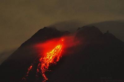
Merapi (5th of January 2021) - Glowing avalanches (photo Oystein)
 2.jpg)
Satellite view - Raung in eruption (July 2015)
RUSSIA - Bezymianny volcano (Kamchatka)
August 28th, 2025
The Kamchatkan Volcanic Eruption Response Team (KVERT) reported that the eruption continued at Bezymianny on 27 August 2025 (local). The aviation alert level at Bezymianny remained at "Yellow" (level 2 on a 4-level scale).As of the 25th of April, the activity at the volcano continues at very high levels. A webcam footage depicts multiple glowing lava-block avalanches descending from the dome during the night of 24 April between 11:02 and 11:20 PM local time. Block-and-ash flows traveled down through the south-eastern flank, accompanied by fine ash plumes—known as phoenix clouds—that separated from the main flow.As of the 10th of April, the eruption continues with the actively growing lava dome. Webcam imagery from the local volcano observatory (Kamchatka Volcanic Eruption Response Team) depicts descending several glowing lava-block avalanches emanating from the lava dome in the night of 9 April. Block-and-ash flows traveled over the eastern flanks accompanied by fine dust plumes (so-called phoenix clouds) as separated from currents. A viscous magma continues to rise into the developing lava dome, resulting in partially unstable hot lava material which is prone to collapse into hot rock falls.KVERT reported that a thermal anomaly over Bezymianny was identified in satellite images during 20-27 March. According to the Institute of Volcanology and Seismology (IVS) of the Far Eastern Branch of the Russian Academy of Sciences (FEB RAS), incandescent debris avalanches descended the SE and/or E flanks and daily summit incandescence was visible during dark hours. An ash plume generated from a debris avalanche rose 100 m above the summit and drifted NE on 21 March.On February 1, 2025, at approximately 10:20 local time, the volcano erupted. Overcast skies obscured visibility, preventing direct observation of the event. Seismic data indicates multiple surface disturbances throughout the day, potentially accompanied by ash emissions reaching up to 4,000 meters above sea level and/or avalanches. Previous news 2024 - KVERT reported that the effusive eruption at Bezymianny continued during 12-19 December and was accompanied by vigorous degassing activity. A thermal anomaly was observed over the volcano in satellite imagery during the reporting period, except for on 13 and 17 December due to weather clouds. The Aviation Color Code remained at Yellow (the second level on a four-level scale).As of the 25th of July, KVERT reported that a sudden increase in the activity occurred at the volcano on 24th of July in the evening. At about 19:29 local time, a pyroclastic flow descended over the slope, which in turn created a tall ash plume - phoenix clouds - towering wall of cloud rising above the pyroclastic torrent, composed of ash elutriated out of flow that rose to 43,000 ft (13,100 m) altitude and extended about 130 km to the southwest and 926 km to the southeast of the volcano with approximate width of 80 km.KVERT reported that a thermal anomaly over Bezymianny was identified in satellite images during 6-9 and 11-13 June. Weather clouds prevented views on 10 June. Dates are UTC; specific events are in local time where noted. Previous news 2023 - As of the 26th of October, the extrusive eruption at the volcano continues at generally elevated levels. Visible glow and near-constant emissions of gas and small amounts of ash suggest continued rise of fresh viscous magma accumulating into the growing lava dome. The pilling hot and loose lava material is prone to collapse, thereby increasing risk of very dangerous pyroclastic flows. Near-frequent glowing dome blocks, emanating from the lava dome, and hot avalanches resulting from lava flow fronts continue to descend over the southeastern dome slope.As of the 17th of October, KVERT reported that the extrusive activity at the volcano has been picking up last night. The local volcano observatory announced that block-and-ash flows raced over the eastern slope of the lava dome between 19:00 and 20:30 UTC. Resulted ash plumes - phoenix clouds - separated from pyroclastic flows and rose up to 3,5 km in height. At the time of the update, ash emissions have extended about 15 km to the northeast of the volcano.KVERT reported that the ongoing eruption at Bezymianny was characterized by gas-and-steam emissions, occasional collapses at the lava dome, and hot avalanches during 20-27 April. A daily thermal anomaly was identified in satellite images. The Aviation Color Code remained at Yellow (the second lowest level on a four-color scale). Dates are based on UTC times; specific events are in local time where noted.As of the 14th of April, KVERT reported that the eruption continues with the actively growing lava dome. The latest image (8 April) of the volcano's activity, taken by the volcanologist Yu. Demyanchuk, shows descending glowing lava block avalanches emanating from the lava dome. Block-and-ash flows continue to travel over the southwestern flanks accompanied by fine dust plumes (so-called phoenix clouds) as separated from currents. A viscous magma continues to rise into the developing lava dome, resulting in partially unstable hot lava material which is prone to collapse into hot rock falls.As of the 7th of April, KVERT reported that a major eruption appeared at the volcano on early morning at 05:38 local time. A spectacular grey ash-abundant plume rose up to 10-12 km altitude and extended about 20 km to the southeast of the volcano. An impressive satellite image acquired from the European Space Agency's Sentinel-2 portrays the significant plume traces affecting the nearest eastern shore by tephra deposits. From accessible images of the eruption from local observers, it could be seen the huge billowing ash column, spreading into an umbrella cloud - an eruption plume region where it rises until it reaches a level of neutral buoyancy, meaning its density is the same as the surroundings.As of the 30th of March, KVERT reported that the activity at the volcano has been gradually increasing over the past few hours. A new explosion appeared from the summit, starting early this morning, at about 06:25 local time, the local institute KVERT reported. The eruption sent a grey ash column to nearly 13,000 ft (3,900 m) altitude that extended about 25 km towards the northeast. Furthermore, according to the KVERT observatory, there is a likelihood of a new viscous lava block that is being squeezed out from the actively growing lava dome and appears forming a "dome on top of a dome".Previous news 2022 - KVERT reported that during 3-10 November a daily thermal anomaly over Bezymianny was identified in satellite images. Strong fumarolic activity was visible, the lava dome continued to grow and was sometimes incandescent at night, and occasional collapses from the dome produced avalanches of hot material. The Aviation Color Code remained at Yellow (the second lowest level on a four-color scale). Dates are based on UTC times; specific events are in local time where noted.KVERT reported that during 27 October-1 November a thermal anomaly over Bezymianny was identified in satellite images. Strong fumarolic activity was visible, the lava dome continued to grow and was sometimes incandescent at night, and occasional collapses from the dome produced avalanches of hot material. The activity had significantly decreased by 2 November. The Aviation Color Code was lowered to Yellow (the second lowest level on a four-color scale). KVERT reported that after its strong explosive eruption on October 23rd and 24th, the extrusive-effusive eruption of the Bezymianny volcano continues; strong fumarole activity, incandescence of the lava dome at night, and hot avalanches accompany this process. Sometimes the large ash clouds formed after hot avalanches, for example, such a 10x13 km ash cloud moved 70 km east of the volcano on October 26th. Likely, the next strong explosive eruption could occur at any time.KVERT reported that a strong explosive eruption occurred on October 23rd, 2022 at 2pm UTC. The explosion sent ash up to 10 km a.s.l.; the ash plume extended 10 km east northeast of the volcano. The observatory reported in a new statement on October 23rd at 22:05 UTC that the strong explosive eruption of the volcano has ended. Satellite and visual data showed an extensive gas-steam plume to the northeast of the volcano, and a bright thermal anomaly over the volcano. An extrusive-effusive eruption of the volcano continues. Ongoing activity could affect low-flying aircraft, and the aviation code has changed back to Orange.KVERT reported that the temperature of the thermal anomalies increases gradually; nocturnal incandescence and strong sporadic fumarolic activity were observed on October 22nd. On 23rd of October, Sentinel-5P Tropomi detected an enhanced SO2 signal of 5.71 DU at a distance of 0.8 km from the Bezymianny. Due to this increase in activity, the aviation code has been raised from yellow to orange. As of the 5th of July, KVERT reported that extrusive-effusive eruption continues, characterized by strong fumarolic activity, incandescence of the lava dome, and hot avalanches that accompany this process. Satellite data from KVERT showed a thermal anomaly over the volcano. KVERT reported that a strong explosive eruptionoccurred on May 28th, 2022. The explosions sent ash up to 10-12 km a.s.l., and the ash plume extended southeast from the volcano and was reported 20 km from the volcano at 07:26Z, it extended over 365 km at an altitude of 15,000 meters at 08:15Z. Mirova reports moderate thermal anomalies of 13 to 33 MW on May 28, 2022. As of the 29th of May at 10:07Z, the Kvert announced that the paroxysmal phase of the explosive eruption was over, but the eruptive activity of the volcano with evacuation of ash up to 5 km altitude continued. Two ash plumes were observed in satellite images. One of the ash plumes on the height of 9.5 km a.s.l. extends 212 km southeast of the volcano; and the other 650 km southeast of the volcano.The aviation code changes back to orange. At 22:19Z, the gas-steam plume with some ash extended 45 km southeast of the volcano; but the approximately 1.635 long large ash cloud also continued to move southeast from the volcano..KVERT reported that the effusive eruption continued during 8-15 April, along with incandescence at the lava dome, avalanches descending the SE flank, and steam-and-ash emissions. A daily thermal anomaly over the dome was identified in satellite images. The Aviation Color Code remained at Yellow (the second lowest level on a four-color scale). Dates are based on UTC times; specific events are in local time where noted.KVERT reported that a daily thermal anomaly over Bezymianny was visible in satellite images during 26 March through 1 April. Strong fumarolic activity, incandescence at the lava dome, and avalanches were also reported. Dome collapses were detected on 25 and 31 March and ash clouds rose to 4 km (13,000 ft) a.s.l., expanding 40 km E and 20 km SW, respectively. The Aviation Color Code remained at Yellow (the second lowest level on a four-color scale). Dates are based on UTC times; specific events are in local time where noted.KVERT reported that after the paroxysmal phase of the eruption with ejction of ash up to 12 km a.s.l. which began at 12:53 UTC on March 15, and the formation of short pyroclastic flows which collapsed in the Vostochnaya valleys and Yuzhnaya the explosive eruption of the Bezymianny volcano has ended. A moderate gas-steam emission from the volcano is currently observed. The activity of the volcano gradually increased on 14.03.2022. A new extrusion of lava was probably superimposed on the lava dome of the volcano, with collapses and small avalanches. A gas-steam plume with some amount of brown ash (old material) extended about 90 km west of the volcano. The extrusive eruption of the volcano continues. A paroxysmal phase of the eruption, with evacuation of ash up to 12 km a.s.l., began at 12:53 UTC on March 15. There was a formation of short pyroclastic flows that collapsed in the Vostochnaya and Yuzhnaya valleys. The eruptive cloud moved north and northeast of the volcano. At present, the eruptive cloud with a size of about 160 by 320 km at an altitude of 6 km a.s.l. and continues to move 620 km northeast of the volcano. Moderate gas-steam emission, possibly with some ash from the volcano, continues. Ongoing activity could affect low-flying aircraft. KVERT reported that an eruptive episode occurred on March 14-15, 2022. VAAC Tokyo detected an ash cloud at 4900 m. She drifted west. Already in the past few days there have been signs of an impending eruption. Petropavlovsk volcanologists have warned that the volcano's seismicity has increased. The Mirova site reports for these 14-15.03 weak to moderate thermal anomalies, between VRP 3 and 85 MW. According to the Global Volcanism Program, the last period of volcanic activity in Bezymianny began on 05.21.2010 and is currently continuing, and is VEI 3. Prior to its 1955-56 eruption, Bezymianny volcano had been considered extinct. Three periods of intensified activity have occurred during the past 3,000 years. The latest period, which was preceded by a 1,000-year quiescence, began with the dramatic 1955-56 eruption. That eruption, similar to the 1980 event at Mount St. Helens, produced a large horseshoe-shaped crater that was formed by collapse of the summit and an associated lateral blast. Subsequent episodic but ongoing lava-dome growth, accompanied by intermittent explosive activity and pyroclastic flows, has largely filled the 1956 crater. KVERT
RUSSIA - Sheveluch volcano (Kamchatka)
October 9th, 2025
As of the 9th of October, KVERT reported continuing eruptive activity at Sheveluch's “300 years of RAS” dome on the SW flank of Old Sheveluch and at the Young Sheveluch dome during 18-25 September. Daily thermal anomalies over the domes were identified in satellite images. Ash plumes were identified in satellite and webcam images rising to 5 km a.s.l. and drifting more than 150 km SE and NW during 18-19 September. Plumes of resuspended ash drifted 1,700 km E and SE during 23-25September. The Aviation Color Code remained at Orange (the second highest level on a four-color scale).KVERT reported that the eruption continued at Sheveluch on 18 September 2025 (local). There were explosions reported, with plumes rising to a maximum of 1,717 m (5,633 ft) above the vent. The aviation alert level remained at "Orange" (level 3 on a 4-level scale). Source: Kamchatkan Volcanic Eruption Response Team (KVERT)KVERT reported that the eruption continued at Sheveluch on 27 August 2025 (local). The aviation alert level at Sheveluch remained at "Orange" (level 3 on a 4-level scale).KVERT reported that lava extrusion may have continued at Sheveluch's “300 years of RAS” dome on the SW flank of Old Sheveluch and at the Young Sheveluch dome during 3-10 April. Daily thermal anomalies over the domes were identified in satellite images. The Aviation Color Code remained at Orange (the second highest level on a four-color scale). Dates are based on UTC times; specific events are in local time where noted.KVERT reported that lava extrusion contnued on the SW flank of Old Sheveluch and at the Young Sheveluch dome during 20-27 March. Thermal anomalies over the domes were identified in satellite images during 21-22 and 25-26 March; weather clouds obscured views on the other days. The Aviation Color Code remained at Orange (the second highest level on a four-color scale).KVERT reported that lava extrusion may have continued at Sheveluch’s “300 years of RAS” dome on the SW flank of Old Sheveluch and at the Young Sheveluch dome during 26 December 2024-2 January 2025. Thermal anomalies over the domes were identified in satellite images on all days except for 28 and 29 December when the weather was cloudy. Previous news 2024 - KVERT reported that eruptive activity at Sheveluch continued during 12-19 December. Vigorous degassing activity accompanied the effusive eruption at the Young Sheveluch lava dome, tThermal anomalies were observed over both domes in satellite images analyzed by KVERT during the reporting period. On December 17, a gas-and-steam plume with small amounts of ash extended at least 95 km WSW of the “300 Years of RAS” lava dome; light ashfall was reported along with snowfall in Klyuchi (50 km SW). The Aviation Color Code remained at Orange (the third level on a four-level scale). Dates are reported in UTC; specific events are in local time where noted.As of the 7th of November at 09:20 UTC, an intense explosive activity occurred at the volcano. The eruption took place likely near the Karan lava dome from where strong ash emissions had been rising up to 10-11 km altitude. The ash plume has been drifting about 22 km to the east-northeast of the volcano. The event has been accompanied by impressive volcanic lightning. It is not yet clear whether the eruption triggered typical pyroclastic flows, as visibility was low during the night.As of the 3rd of September, the explosive phase that commenced on 1 September continues. Copious grey ash emissions are spewing from the '300-Year-Old RAS'lava dome. The ash plume has been dissipating about 65 km to the east of the volcano, according to the latest update from the local observatory. As of the 2nd of September, the explosive-extrusive eruption at the volcano continues. On 1st of September at about 11:15 UTC an explosion took place from the recently formed '300-Year-Old RAS'lava dome, located on the SW flank of the Karan lava dome. The eruption sent glowing lava bombs to upper slopes that, in turn, into incandescent avalanches. An ash plume dissipated about 65 km to the northeast of the volcano.As of the 19th of August, KVERT reported that the explosive period at the volcano likely halted. Nevertheless, the extrusive activity continues from two sites : the '300-Year-Old RAS'and the 'New'lava domes — located near the Karan lava dome. The ash plume has reached a height of approximately 1,900 meters and has extended about 2,400 kilometers to the east of the volcano (19:20 UTC, 18 August). As of the 18th of August, KVERT reported that the volcano showed a very dramatic activity over the past hours. A significant above-average explosion took place from the main lava dome (according to the local observatory, highly likely from Young Shiveluch). The eruption triggered a dense dark ash column, which has became continuous and rose to estimated 23,000 ft (7,000 m) altitude as the Volcanic Ash Advisory Center (VAAC) Tokyo reported. Ash emissions have propagated about 920 km (at the time of the issuing the volcano observatory's report, 11:13 PM UTC on August 17, 2024) to the southeast of the volcano. KVERT reported that thermal anomalies over both the new and older lava domes at Sheveluch were identified in satellite images during 6-7 and 11-13 June; the domes were obscured by weather clouds during 8-10 June. The Aviation Color Code remained at Orange (the third level on a four-color scale). Dates are based on UTC times; specific events are in local time where noted.As of the 18th of may, the extrusive eruption at the volcano continues. Both Sentinel-1 (SAR) and Sentinel-2 (Short wave infrared composite, known as SWIR) from recent days confirm the new Karan-1 lava dome to be growing on the southwestern flank of the volcano. Simultaneously, the Young Shiveluch lava dome continues to grow within the pre-eruption extrusive Karan dome crater that was partially destroyed by the massive explosion on 11 April last year. It has been forming as the "dome in the dome area".On 7 May, volcanologists from the KVERT Institute ventured into the field to survey the area near the volcano. The following day, they embarked on a forced march to reach the newly formed Karan-1 lava dome. The team conducted thorough photo and video documentation of the new dome using both visible and infrared spectrums. While the exact dimensions are yet to be determined, initial estimates suggest a height exceeding 70 meters. The dome continues to grow, accompanied by frequent debris avalanches. Following the elevated seismic activity, a new lava dome began to grow on 26 April, as reported by the KVERT. Visual and satellite observations confirmed a new dome growth located on the southwestern flank of the volcano. This phenomenon is visible in the attached SAR (Synthetic Aperture Radar) visualization from the Sentinel-1. According to the satellite image, the lava dome appears smooth with a curved outer surface, resembling previous lava domes at the volcano. Viscous, gas-poor magma has been accumulating within the dome. The extrusive eruption has been accompanied by the powerful gas-steam eruption on 30 April, generating the two-km gas-and-steam-laden eruption plume above the Karan dome. As of the 28th of April, KVERT reported that an elevated seismic activity began to occur at the volcano on 24 April. Seismic networks at Sorokina and Baydarnaya detected an increased number of earthquakes beneath the Karan dome area. The activity gradually intensified, and in the night, from 24 to 25 April, the eruption commenced. The current conditions in the Shiveluch region are experiencing severe weather, characterized by strong winds and heavy snowfall. The entire area is obscured by thick clouds.Previous news 2023 - KVERT reported that the eruption at Sheveluch continued during 1-7 December. A daily thermal anomaly was identified in satellite images. During 3-6 December plumes of resuspended ash drifted about 230 km E and SE. The Aviation Color Code remained at Orange (the third level on a four-color scale). Dates are based on UTC times; specific events are in local time where noted.KVERT volcano observatory raised the volcano's local alert level to "Red"on 28th of July. The alert status change followed explosions generating ash plumes to heights of 4.5 km at 02:00 UTC and up to 7-7.5 km elevation at 04:10 UTC today, respectively. Plumes extended about 26 km to the northeast of the volcano. The new lava dome (Young Shiveluch) growth appears to ooze out as erupted viscous lava, giving it a smooth, egg-like shape as visible in the latest Sentinel-2 satellite imagery. A thermal anomaly is also being detected in the area of the Karan dome, presumably associated with the new lava dome growth. On 29 June, a group of volcanologists from the local observatory did a field research to take gas samples and temperature measurements of fumaroles from the Karan dome area. The team climbed up to nearly 1800 m altitude to survey ongoing strong steam-laden plumes that appeared 20 days after the massive eruption at the volcano on 11 April. The extrusive eruption at the volcano continues.As of the 25th of June, the extrusive eruption at the volcano continues. The new lava dome, dubbed Young Shiveluch, continues to grow within the pre-eruption extrusive Karan dome crater that was partially destroyed by the massive explosion on 11 April and forms the "dome in the dome area". The new lava dome growth appears to ooze out as erupted viscous lava, giving it a smooth, egg-like shape as visible in the latest Sentinel-2 satellite imagery. A thermal anomaly is also being detected in the area of the Karan dome, presumably associated with the new lava dome growth. Both dome areas are accompanied by the continuous strong gas-steam emissions.As of the 30th of May, the extrusive eruption at the volcano continues. The new lava dome continues to grow within the pre-eruption extrusive dome crater that was partially destroyed by the massive explosion on 11 April and forms the "dome in the dome area". The new lava dome growth appears to ooze out as erupted viscous lava, giving it a rugged outer shape by exceeding limits of plastic deformation. The local institute Kamchatka Volcanic Eruption Response Team (KVERT) reported that strong prevailing eastern winds lifted ash deposits (tephra), located on the southeastern slopes of the volcano, and carried it about 30 km eastward on 28 May.On 4 May, local volcanologists carried out a flight observation to investigate the current volcano's activity and its lava dome area. Visibility during the flight was very limited due to low-level clouds, which made the active lava dome and pyroclastic flow deposits impossible to observe in detail. Despite weather conditions, three strong steam-laden plumes (so-called fumaroles) were detected on the western slope that appeared to be active even after 19 days after the massive eruption.As of the 1st of May, visual observations confirmed a new dome growth from the active, partially destroyed lava dome area. The new lava dome growth appears to ooze out as erupted viscous lava, giving it a rugged outer shape by exceeding limits of plastic deformation. Meanwhile, the ongoing strong gas-steam-rich (so-called degassing) plumes have been dominating the volcano over the past few days.As of the 30th of April, eplosive activity continues. Volcanic Ash Advisory Center (VAAC) Tokyo warned about a volcanic ash plume that rose up to estimated 14000 ft (4300 m) altitude or flight level 140 and is moving at 15 kts in S direction. On 27 April, a group of local volcanologists leading by Yuri Demyanchuk went to investigate the consequences of the massive eruption in the area of Bekesh river on the south of the volcano. They found the base camp completely destroyed by the large pyroclastic flow. The riverbed, nearby forest and snow are covered by tephra ash layers. In addition, snow is being melted at the contact with sun which in turn forms a thick mud-ash blend.. The pyroclastic flow stopped about 2 km from a bridge crossing the river with a tephra ash deposit thickness of about 10 cm. Judging from the latest satellite image of the volcano, the block-and-ash flow deposits seem to cover an area of about 100 km2 and reach about 21 km distance from the lava dome area (EO Browser measure tool).The ongoing strong gas-steam-rich (so-called degassing) plumes and vulcanian-sized eruptions have been dominating the volcano over the past few daysThe increased ash and sulfur dioxide emissions from the volcano continue to travel eastward along vast stretches of the Gulf of Alaska. The latest NWS Juneau satellite-based measurements of SO2 and fine ash concentrations in the atmosphere depict how particles gradually have been reaching the western and northwestern Canada, distant approx. 4,300 km from the volcano, and it appears to continue further towards the east. (image)Therefore, this situation led to disruption of several flights operated by Canadian North Airlines within the Yellowknife, Alaska, Northwest Territories, Northern British Columbia, and Alberta provinces due to poor visibility. Fine ash particles present a danger to aviation and in order to mitigate risk, precautions with air traffic must be taken..As of the 15th of April, KVERT reported that explosive activity continues. Volcanic Ash Advisory Center (VAAC) Montreal warned about a volcanic ash plume that rose up to estimated 38000 ft (11600 m) altitude or flight level 380 and is moving at 20 kts in NE direction. The massive eruption paroxysm at the volcano on 11 April caused the lava dome to destroy over its vast central area. Thus, the pre-eruptive dome-shaped structure seems to reshape itself into a new caldera (2 x 2.6 km2 according to the EO Browser measure tool) with a (most likely) oozing viscous magma within it again, forming likely a new dome.(image). The information refers to the latest acquired satellite and webcam images as we come across it. According to the local volcanologist Alexey Demyanchuk, the eruption was being directed to the southeast. Now, we may conclude the event was recognized as Peléean-type eruption as the explosion destroyed the growing lava dome resulting in pyroclastic currents. As of the 12th of April, KVERT reported that the volcano is dominated by ongoing strong vulcanian-type explosions and generally continues at highly elevated levels after the dramatic paroxysm activity. Intermittent, but relatively vigorous eruptions have generated grey, still spectacular billowing ash plumes over the past 24 hours. Tall and dense columns sent fine volcanic ash up to 12 km, 10 km and 8,5 kilometers in height. The original ash plume from the massive eruption yesterday has extended about 1300 km to the east of the volcano.As of the 11th of April, KVERT reported that a major explosion occurred (photo). More precise information comes from the local volcanologist Yury Demyanchuk. The eruptive phase began at 01:00 local time tonight, followed by strong events at 02:00 and 03:00 local time and finally by the reported massive one at 06:00. In the last update he spectacular ash cloud has been reported drifting 340 km to the north-northwest and about 240 km to the west-southwest of the volcano, it has been gradually spreading along vast stretches of the western-southwestern Kamchatka due to prevailing winds. The plume is currently extended about 435 km from the volcano. The eruption has been accompanied by continuous lightning and rumbling by 10:00 local time. Soon after the eruption, at about 06:30 local time, a heavy fall of grey-brown-to-reddish ash fine particles started to occur in Klyuchi village, consequently, the sky got darkened at about 07:00 local time. At about 09:30 local time, the eruption plume covered Kozyrevsk village with a thick ash tephra blanket. The local ground is being covered by a thick ash tephra blanket with a width of about 6-8 cm. The color of most particles, up to a few mm in size, was mostly brown to reddish brown, described as "earthy". This could mean that most of the ejected material might be from older lava rocks in the summit craters or inside the vent. According to Alexey Demyanchuk, a strong smell of gas is being reported. Satellite-based measurements of SO2 concentrations in the atmosphere, acquired by the TROMOPI sensor, show the impressive SO2 plumes ejected by the volcano. Estimated sulfur dioxide (SO2) emissions within the 300 km plume dimension are about 356.9 ktons. About damages, a diesel power plant got broken and a couple of complaints on social media reported dirty water from drainages due to ash-filled pipes. Given the relatively high eruption rate, neither injuries nor fatalities have been reported yet. At about 10:30 local time, the sky started to brighten up again. The eruptive period came without warning, even though the volcano had been in the ongoing high state of activity levels during the recent weeks, no detected precursor was registered.As of the 7th of April, explosive activity continues. Volcanic Ash Advisory Center (VAAC) Tokyo warned about a volcanic ash plume that rose up to estimated 13000 ft (4000 m) altitude or flight level 130 and is moving at 20 kts in SE direction.As of the 29th of March the extrusive activity of the volcano has increased. The local volcanologist carried out a field survey in the vicinity of the volcano a few days ago to report that the lava dome is growing again at intense values. The active lava dome continues to produce frequent incandescent rock falls to the south-southeast, from at least two active areas of the huge dome. From time to time, ash plumes separate from block-and-ash flows (so-called phoenix clouds) as it descends the slope. Emissions of gas and steam plumes with minor amounts of ash reached heights between 12,000 ft (3,700 m) and 15,000 ft (4,600 m) over the past few days.KVERT reported that the ongoing eruption at Sheveluch was generally characterized by explosions, hot avalanches, lava-dome extrusion, and strong fumarolic activity. A daily thermal anomaly was identified in satellite images during 9-16 March. Ash plumes drifted as far as 62 km E on 11 March. The Aviation Color Code remained at Orange (the second highest level on a four-color scale). Dates are based on UTC times; specific events are in local time where noted. As of the 14th of March, explosive activity continues. Volcanic Ash Advisory Center (VAAC) Tokyo warned about a volcanic ash plume that rose up to estimated 13000 ft (4000 m) altitude or flight level 130 and is moving at 10 kts in NE direction.As of the 11th of March, the explosive activity continues. Volcanic Ash Advisory Center (VAAC) Tokyo warned about a volcanic ash plume that rose up to estimated 13000 ft (4000 m) altitude or flight level 130 and is moving at 20 kts in E directionAs of the 6th of March, KVERT reported that the intense activity of the volcano persists. Dense grey abundant ash emissions have been bursting from the actively growing lava dome . This might be caused by either a continuous eruption or ash plumes (so-called phoenix clouds) separating from pyroclastic density currents (block-and-ash flows) as they descended the slope or both phenomena. The Volcanic Ash Advisory Center (VAAC) Tokyo reported at about 18:00 local time the ash plume which reached to 17,000 ft (5,200 m) elevation and dissipated about 10 km to the east of the volcano. The active lava dome continues to grow and produce frequent incandescent rock falls to the south-southeast. As time passes and the dome continues to grow larger and larger, the risk of a sudden, potentially very large collapse event resulting in massive pyroclastic flows and explosions increases. Pyroclastic flows are deadly, turbulent hot avalanche of lava rock fragments of all sizes embedded in a mixture of turbulent gas and ash racing down slopes.KVERT reported that the ongoing eruption at Sheveluch was generally characterized by explosions, hot avalanches, lava-dome extrusion, and strong fumarolic activity. A daily thermal anomaly was identified in satellite images during 23 February-2 March. At 1150 on 5 March local time video images showed an ash plume generated by hot avalanches rising 5.5 km a.s.l. (just over 2.2 km above the summit) and drifting 5 km NE.As of the 26th of February, KVERT reported that the extrusive activity of the volcano remains intense. The active lava dome continues to grow and produce frequent incandescent rock falls to the south-southeast, from at least two active areas of the huge dome. From time to time, ash plumes separate from block-and-ash flows (so-called phoenix clouds) as it descends the slope. Emissions of gas and steam plumes with minor amounts of ash reached heights between 12,000 ft (3,700 m) and 15,000 ft (4,600 m) over the past few days. As time passes and the dome continues to grow larger and larger, the risk of a sudden, potentially very large collapse event resulting in massive pyroclastic flows and explosions increases.KVERT reported that the ongoing eruption at Sheveluch during 9-16 February was generally characterized by explosions, hot avalanches, lava-dome extrusion, and strong fumarolic activity. A daily thermal anomaly was identified in satellite images. The Aviation Color Code remained at Orange (the second highest level on a four-color scale). Dates are based on UTC times; specific events are in local time where noted.As of the 23rd of January, according local scientist, the extrusive activity at the volcano appears to decrease significantly. Nevertheless, the frequent vivid glow in the upper part of the growing lava dome continues and hints intruding viscous magma into it. Small glowing lava blocks and debris avalanches travelled over the slopes during the past few days. Emissions of gas, steam plumes and ash reached heights between 13,000 ft (4,000 m) and 16,000 ft (4,900 m) over the past few days detected by the Volcanic Ash Advisory Center (VAAC) Tokyo.As of the 9th of January, KVERT reported that the extrusive eruption at the volcano continues. Visual observations confirmed the continuous rise of viscous magma into the growing lava dome. Accumulating magma makes the lava dome partially unstable, which develops into glowing lava blocks and debris avalanches. From time to time, ash plumes separate from block-and-ash flows (so-called phoenix clouds) as it descends the slope. Emissions of gas, steam plumes and ash reached heights between 13,000 ft (4,000 m) and 25,000 ft (7,600 m) over the past few days. The seismic network detected the continuous seismic tremor. Explosive activity continues on 2nd of January 2023. Volcanic Ash Advisory Center (VAAC) Tokyo warned about a volcanic ash plume that rose up to estimated 15000 ft (4600 m) altitude or flight level 150 and is moving at 15 kts in E direction.The Molodoy Shiveluch lava dome complex was constructed during the Holocene within the large horseshoe-shaped caldera; Holocene lava dome extrusion also took place on the flanks of Stary Shiveluch. At least 60 large eruptions have occurred during the Holocene, making it the most vigorous andesitic volcano of the Kuril-Kamchatka arc. Widespread tephra layers from these eruptions have provided valuable time markers for dating volcanic events in Kamchatka. Frequent collapses of dome complexes, most recently in 1964, have produced debris avalanches whose deposits cover much of the floor of the breached caldera... (GVN/GVP) . Live cam link
RUSSIA -Maly Semyachik volcano (Kamchatka)
April 24th, 2018
KVERT reported that activity at Maly Semyachik increased during the second half of March; the ice covering the crater lake melted within a 5-6-day period, and a weak thermal anomaly was visible in satellite images. The Aviation Color Code was raised to Yellow (the second lowest level on a four-color scale) on 22 March. A weak thermal anomaly continued to be detected through 20 April, though no further activity prompted KVERT to lower the Aviation Color Code to Green. Maly Semyachik is a compound stratovolcano located in a 10-km-wide caldera within the 15 x 20 km mid-Pleistocene Stena-Soboliny caldera. Following construction during the late Pleistocene of the Paleo-Semiachik volcano beginning about 20,000 years before present (BP), activity migrated to the SW, forming Meso-Semiachik (about 11,000-9000 BP) and Ceno-Semiachik (about 8000 BP to the present). An initial stage lasting about 3500 years was dominantly explosive, constructing the present cone. A second stage beginning about 4400 years ago was marked by alternating constructive and destructive processes during which the volcano was destroyed by major explosions and then reconstructed. A crater lake fills the historically active Troitsky Crater, which formed during a large explosive eruption about 400 years ago. (GVN/GVP)
RUSSIA - Karymsky volcano (Kamchatka)
October 9th, 2025
As of the 9th of October, KVERT reported that explosions at Karymsky were last observed in August. In September activity was at moderate levels characterized by steam-and-gas emissions and a weak thermal anomaly identified in satellite images; weather clouds sometimes obscured views. On 25 September the Aviation Color Code was lowered to Yellow (the second level on a four-color scale).KVERT reported moderate levels of activity at Karymsky during 20-27 March. Thermal anomalies over the volcano were identified in satellite images on 21 March; weather clouds obscured views on the other days. On 30 March, KVERT lowered the Aviation Color Code from Orange (the third level on a four-color scale) to Yellow (the second level on a four-color scale), noting that eruptive activity was last observed on 12 November 2024.Previous news 2024 - KVERT) reported that moderate levels of activity continued at Karymsky during 12-19 December. Satellite data analyzed by KVERT showed a thermal anomaly over the volcano on 15 December; weather clouds prevented observations in satellite images on the other days. The Aviation Color Code remained at Orange (the third level on a four-level scale).Visual observations by volcanologists at Uzon volcano confirmed a new eruptive phase on 30 August. Six explosions released ash plumes that reached altitudes of up to 33,000 ft (10,000 m) and propagated about 48 km to the east-northeast of the volcano.Following the strong eruption at the volcano on 24 July last week, noticable pyroclastic flow deposits formed on the southeastern flank. The latest Landsat 8-9 acquistion from 29 July detected approx. 7 km-long ignimbrites, welded pyroclastic rock formed by widespread deposition and consolidation of resulting pyroclastic density currents. On 24 July at about 19:29 local time, the massive pyroclastic flow descended over the southeastern slope, which in turn created the tall ash plume - phoenix clouds - towering wall of cloud rising above the pyroclastic torrent, composed of ash elutriated out of flow that rose to 43,000 ft (13,100 m) altitude and extended about 130 km to the southwest and 926 km to the southeast of the volcano with approximate width of 80 km.As of the 29th of June KVERT reported that the explosive eruption at the volcano continues. Over the past few days, the Volcanic Ash Advisory Center (VAAC) Tokyo detected an ash removal reaching altitudes varying between 12,000 ft (3,700 m) and 20,000 ft (6,100 m) elevation. On June 28, a dark grey, dense ash column rose about 2,5 km above the summit vent, ejecting and spreading tephra about 32 km to the south of the volcano. Previous news 2023 - On June 21, the KVERT reported an explosion from the volcano that released ash emissions up to 3 km in elevation, which extended approximately 30 km west of the volcano. In the following days, the Volcanic Ash Advisory Center (VAAC) Tokyo detected a series of additional ash emissions reaching altitudes of 9,000 ft (2,700 m) and 12,000 ft (3,700 m).KVERT lowered the Aviation Color Code for Karymsky to Green (the lowest level on a four-color scale) on 12 January, noting that ash explosions were last detected on 7 August 2022. A minor thermal anomaly visible in satellite images and moderate levels of gas-and-steam emissions persisted. Dates are based on UTC times; specific events are in local time where noted. Previous news 2022 -KVERT reported that a thermal anomaly at Karymsky was identified in satellite images on 4 and 9 November. Gas-and-steam emissions persisted. The Aviation Color Code remained at Yellow (the second lowest level on a four-color scale). Dates are based on UTC times; specific events are in local time where noted.As of the 6th of August, KVERT reported that moderate explosive activity continues.Satellite data showed that an ash plume reaching 3,500 m.asl. extends over 28 km to the north northeast of the volcano.KVERT reported that eruptive activity of the volcano continues at moderate levels with sporadic powerful explosions as occurred at 21:44 local time on 2nd of August. A spectacular vulcanian eruption produced a dense grey ash plume, which reached approx. 17,000 ft (5,200 m) altitude and drifted about 12 km to the S-SW of the volcano.Moderate explosive activity was reported by KVERT on July 29 with an ash plume at 3,500-4,000 m. drifting 43 km to the southeast of the volcano.KVERT reported that explosive activity increasing on July 13, 2022. Himawari-8 satellite data from 13.07 to 10.50 a.m. showed an ash plume up to 8,500 meters a.s.l. extending to the southwest of the volcano. After the eruption at 10:50 a.m. on July 13, the ash cloud continues to be observed at a distance of 350 km southwest of the volcano, at 3,000 m. amsl. On 14.07 / 00:56, KVERT reports moderate explosive activity of the volcano which continues. Satellite data showed an ash cloud drifting southeast from the volcano, 3000m. amsl. Distance from ash plume/volcano cloud: 369 km. Moderate activity of the volcano continues. Ash explosions up to 12 km (39,400 ft) a.s.l. could occur at any time. Ongoing activity could affect international and low-flying aircraft. The color code for aviation remains orange. KVERT reported that a thermal anomaly over Karymsky was identified in satellite images during 20 and 23-27 May. The Aviation Color Code remained at Orange (the second highest level on a four-color scale). Dates are based on UTC times; specific events are in local time where noted. KVERT reported that a moderate eruptive activity continues. A thermal anomaly over the volcano was visible in satellite images from April 29th to May 6th. The on May 4th, explosions generated ash plumes that reached 3,200 m. above sea level. and drifted about 60 km to the SW. This May 11, the explosions sent ashes up to 6,000 m. altitude, and a 7x10 km ash cloud moves 25 km west-northwest of the volcano. KVERT reported that a thermal anomaly over Karymsky was visible in satellite images on most days during 22-29 April. Explosions during 21-22 April produced ash plumes that rose as high as 5 km (16,400 ft) a.s.l. and drifted around 95 km E and SE. Explosions at 1410 on 28 April, local time, generated an ash plume that rose to 10 km (32,800 ft) a.s.l., was about 5 x 7 km at its top, and drifted WNW. The Aviation Color Code was raised to Red (the highest level on a four-color scale). By 1550 the ash cloud had spread to 28 x 34 km in size and had drifted almost 290 km WNW at an altitude of 9 km. The Aviation Color Code was lowered to orange because ash was no longer being emitted from the volcano. The plume had drifted more than 1,000 km before dissipating.As of the 20th of April, KVERT reported that a vigorous vulcanian eruption occurred from the volcano's summit crater. According to the local observatory, a spectacular dense ash-rich plume was seen rising up to 10 km altitude from Kronotskiy Zaliv and extended about 29 km to the NE of the volcano. Explosions continued and within an hour produced larger ash plumes that rose 9.8 to 10 km above sea level and drifted nearly 30 km to the NE.Satellite data from KVERT showed that on April 19 at 9:30 p.m., explosions sent ash up to 6 km above sea level, with the ash plume extending south-southwest from the volcano. The aviation code is orange.KVERT reported that a thermal anomaly over Karymsky was visible in satellite images on 3 and 5-6 April; the volcano was quiet or obscured by clouds on the other days during 1-8 April. The Aviation Color Code remained at Orange (the second highest level on a four-color scale). Dates are based on UTC times; specific events are in local time where noted.KVERT reported that a thermal anomaly over Karymsky was visible in satellite images during 22-23 March. The volcano was either quiet or obscured by clouds on the other days during 18-25 March. The Aviation Color Code remained at Orange (the second highest level on a four-color scale). Dates are based on UTC times; specific events are in local time where noted.KVERT reported that a thermal anomaly over Karymsky was visible in satellite images during 13-16 March. The volcano was either quiet or obscured by clouds on the other days during 11-18 March. The Aviation Color Code remained at Orange (the second highest level on a four-color scale). Dates are based on UTC times; specific events are in local time where noted. Karymsky, the most active volcano of Kamchatka's eastern volcanic zone, is a symmetrical stratovolcano constructed within a 5-km-wide caldera that formed during the early Holocene. The caldera cuts the south side of the Pleistocene Dvor volcano and is located outside the north margin of the large mid-Pleistocene Polovinka caldera, which contains the smaller Akademia Nauk and Odnoboky calderas. The latest eruptive period began about 500 years ago, following a 2300-year quiescence. Much of the cone is mantled by lava flows less than 200 years old. Historical eruptions have been vulcanian or vulcanian-strombolian with moderate explosive activity and occasional lava flows from the summit crater.
RUSSIA - Kliuchevskoy volcano (Kamchatka)
October 18th, 2025
On 14 October at dusk, a strong glow was observed at the summit of the volcano. Likely strombolian activity took place atop the edifice that continued until 16 October with a decreasing trend. The activity was associated with a strong degassing reaching about 800 meters above the crater. An ash plume reached an altitude of 6,5 km, propagating northeast.As of the 9th of October, KVERT reported that wind was no longer resuspending ash previously deposited on the N flank of Klyuchevskoy. Only fumarolic emissions were observed. The Aviation Color Code was lowered to Green (the lowest level on a four-color scale) on 25 September.As of the 18th of August explosive activity continues. Volcanic Ash Advisory Center (VAAC) Anchorage warned about a volcanic ash plume that rose up to estimated 32000 ft (9800 m) altitude or flight level 320 and is moving at 25 kts in SE direction. The eruption at the volcano continues. On 14 August, a spectacular ash plume was detected rising to an estimated 8 km altitude, releasing dense ash emissions. The other day, a weak ashfall was monitored in the Klyuchi village. There are two summit vents from which incandescent material is being ejected to an approximate height of 500 meters above the crater. The lava flow that has been active over the past few days has not been observed; only weak glowing detected via satellite image by Sentinel-2.As of the 8th of August, explosive activity continues. Volcanic Ash Advisory Center (VAAC) Tokyo warned about a volcanic ash plume that rose up to estimated 40000 ft (12200 m) altitude or flight level 400 and is moving at 60 kts in SE direction.As of the 6th of August, the effusive-explosive eruption at the volcano continues. The lava flow on the southwestern slope remains active, and it descends towards the Bogdanovich Glacier. A tall ash plume generates dense ash emissions up to 8 km elevation, associated to intense strombolian activity atop the edifice.As of the 4th of August, explosive activity continues. Volcanic Ash Advisory Center (VAAC) Tokyo warned about a volcanic ash plume that rose up to estimated 35000 ft (10700 m) altitude or flight level 350 and is moving at 30 kts in NW direction. A new lava flow commenced to descend from atop the summit that emerges on the western slope. As of the 31st of July, thexplosive activity continues. Volcanic Ash Advisory Center (VAAC) Tokyo warned about a volcanic ash plume that rose up to estimated 20000 ft (6100 m) altitude or flight level 200 and is moving at 10 kts in E direction. As of the 30th of July, an eruption began shortly after a powerful magintude 8.8 earthquake that hit Kamchatka area, and several aftershocks shook the region.The ash plume from the eruption extended at least 1.5 miles (2.5 kilometers) above and 36 miles (58 km) east of the volcano, according the Kamchatkan Volcanic Eruption Response Team The group warned that explosions of ash up to 5 miles (8 km) high could occur at any time. A lava effusion occurred on the western slope. In the weeks leading up to the earthquake, the volcano was showing signs of unrest. On July 21, a team of Russian scientists found a lava lake at the summit of the volcano, signaling that the volcano was primed for eruption. A new eruption appeared at the volcano on 20 April. First in 2025. A webcam imagery showed a glowing steam from atop the summit indicating likely minor strombolian activity. Whether a new lava started to emerge is unclear yet. Previous news 2024 - As of the 7th of November,KVERT reported that over the past month, the latest Sentinel-2 satellite acquisition detected elevated levels of water vapor and gas emissions from the volcano, mainly on 4 November as a relatively strong steam plume was emitted from the summit vent. By then, a passive venting of gas and steam emissions has been observed from the summit vent. The volcano has been mostly calm since early January when the recent eruptive phase ended. Whether it might be an early-phase indicator of an imminent eruption is unclear yet.The explosive eruption of the volcano ended, the KVERT reported. Thus, the eruptive period lasted only from 27 December to 1 January. The volcano is characterized by sustained fumarolic activity, i.e. steam-laden plumes continue to emit from the summit vent. As of the 28th of December, KVERT reported that after little more than one month since the last paroxysm period at the volcano, a new eruption seems to be commenced at the summit. The latest satellite image and even webcam views from 28 December indicate a night-time glowing steam (a thermal anomaly, respectively), suggesting a rise of a new batch of magma shifting inside the volcano's feeder pipe towards the vent. The activity is associated with a strong degassing, i.e. active venting of volcanic gases (SO2, CO2) from the main vent.As of the 20th of November, volcanologists from the local observatory made a flight survey to examine the volcano's conditions after the recent strong eruptive episode. A vast part of the edifice's ice-snow flanks is covered by fresh ash deposits known as tephra. The most notable change in the volcano's morphology is the scar-like deepened southern Apakhonchich chute resulting from the erosion of intense lava flows and debris avalanches racing down over the drainage during the paroxysm period. The activity at the volcano is characterized by "only" venting of gas and steam emissions from the summit vent.As of the 5th of November, according to the Kamchatka Volcanic Eruption Response Team (KVERT) institute, the eruptive period at the volcano ceased. From the latest satellite imagery of the volcano acquired on 3 November, a relatively strong thermal anomaly is being detected on the northern, western and south-southeastern slopes, confirming lava flows from the recent strong paroxysm explosion. This might suggest the crystallization process of emissions of lava. Residual dust emissions remain confined in the area of the volcano and obscure clear views of lava flows. Old-deposit debris avalanches/landslides continue to generate ash plumes as they collapse from the Apakhonchich lava flow levees. Lava levees are natural banks of lava flow as they cool and congeal along the banks.The remarkable eruption at the volcano created another volcanic-related phenomenon on 1st of November. Lahars (mud flows) started to form as lava flows on the north flank melted snow and ice and caused lahars which traveled along the Studenoy river. Mud flows reached the Kozyrevsk-Petropavlovsk highway and cut it off. Moreover, another lahar, flowing along the Krutenkaya river, blocked the road east of Klyuchi village towards the local volcanology institute's base camp at Podkova and Apakhonchich. Meanwhile, the activity of the volcano has decreased. A height of the eruption column lowered to 3 km.As of the 1st of November, KVERT reported that the volcano has been showing dramatic activity over the past hours. The explosive eruption at the summit vent has been picking up and culminated into a powerful vulcanian-sized ash column. Abundant grey constant emissions of very fine ash rose up to estimated 14 km (46,000 ft). The ash plume has been traveling along vast stretches about 1500 km to the south-southeast of the volcano at the time of this updates. The Aviation Color Code for the volcano was raised to "RED"As of the 31st of october, the effusive-explosive eruption at the volcano continues at high levels. The Aviation Color Code for the volcano was raised to "RED" as increasing ash emissions present a danger to aviation, and precautions with air traffic must be taken. The constant ash-rich plume has dispersed about 192 km to the south-southwest of the volcano and continues to extend further. Most fine ash particles (according to the KVERT) have been generated from old-deposit debris avalanches/landslides that lifted ash plumes as they descended the flank. The ongoing summit paroxysm episode continues to release a considerable amount of ash and gas emissions, as well.As of the 29th of October, the effusive-explosive eruption at the volcanocontinues, characterized by two active lava flows on different slopes and vigorous strombolian eruptions from the summit crater. The lava continues to ooze out from the summit vent, keeping the flow active along the Apakhonchich chute and relatively quickly advancing more than halfway to the base of the edifice. Emissions of fluid and incandescent lava on the southeastern flank have increased in length, currently about 3,77 km long. Glowing lava blocks frequently detach from the flow front, generating grey dust as it descends over the slope. Simultaneously, another active lava arm continues to erupt from the northwestern flank vent (so-called lateral eruption). This time, the lava flow along the southwestern Kozyrevsky channel appears inactive.As of the 28th of October, explosive activity continues. Volcanic Ash Advisory Center (VAAC) Tokyo warned about a volcanic ash plume that rose up to estimated 18000 ft (5500 m) altitude or flight level 180 and is moving at 20 kts in SE direction.As of the 26th of October, KVERT reported that strombolian activity at the volcano has been picking up. Judging from the newest acquired thermal Sentinel-2 satellite image, it seems a new lava flow started to emerge from the northwestern vent (so-called lateral eruption). In addition, the lava appears to travel along the southeastern Apakhonchich chute again. This time, it seems that the lava flow doesn't emerge along the southwestern Kozyrevsky channel which has been active recently.As of the 25th of October, the intense effusive-explosive eruption at the volcano continues. The lava-fountaining episode (so-called paroxysm) continues from the summit vent characterized by throwing of incandescent lava material to an approx. height of several hundred meters above the crater. The spattering continues to build the already-formed cinder cone within the main vent. A considerable amount of hot fluid blebs land off the crater terrace to coalesce thereby and reactivate the formerly lava on the southwestern Kozyrevsky channel. This time, it seems that the lava flow doesn't emerge along the southeastern Apakhonchich chute. Easterly dissipating ash emissions reached an altitude of 18,000 ft (5,500 m) and extended about 60 km of the volcano. As of the 16th of October, the heightened effusive-explosive eruption at the volcano persisted. The elevated fountaining episode (so-called strombolian activity) continues atop the summit, which has been building the spatter cone by piling glowing lava spatter material. Some lava fragments (lapilli and bombs) are being ejected outside the crater rim to approx. height of 100-200 meters. The effusing lava continues to keep the flow along the southeastern Apakhonchich chute active. Incandescent avalanches have been sliding down the slope as lava blocks detach from the lava flow. Phreatic (hydrothermal) explosions occur as hot, fluid emissions of lava interact at the contact with snow and ice and generate copious steam-gas-laden plumes.As of the14th of october, the activity remains elevated. Today's close-up satellite view of the volcano reveals the continuous thermal radiation at the summit, indicating spilling lava flows along the southeastern Apakhonchich and the southern Kozyrevsky chutes. In addition, copious gas and steam emissions at the southeastern base of the edifice suggest detached hot lava flow blocks from the front of lava that interact with snow and ice when racing down the slope. A visible night-time glow and near-constant emissions of gas ash via surveillance cameras suggest the continued rise of fresh magma within the conduit. An ash plume extended about 110 km to the southeast of the volcano today, the KVERT reported.As of the 11th of October, KVERT reported that the activity of the volcano has intensified last night. A certain amount of ash has been occurring in an increasingly gas-steam-rich plume, extending about 65 km to the northeast of the volcano. The latest Sentinel-2 satellite image confirmed increased emitting emissions. This may hint a new batch of magma injection inside the volcano's main conduit that is being fragmented into fine-ash particles. Strombolian activity continues within the summit vent, characterized by minor lava fountains that have been building the growing spatter cone and also supplying lava flows alternately along the southeastern Apakhonchich and the southern Kozyrevsky chutes. Glowing lava spatter is constantly being ejected to approx. height of 100-200 meters above the crater.As of the 2nd of October, KVERT reported that the effusive-explosive eruption at the volcano continues. The lava, keeping the flow active, continues to feed the southeastern Apakhonchich chute, currently about 500 m long. Incandescent avalanches form as glowing lava blocks frequently detach from the lava flow front and tumble down the SE slope, descending at least 4,000 meters from the summit. Minor strombolian-type explosions continue to appear, which has been building a cinder cone within the summit vent at regular intervals of every 10 minutes. Glowing lava spatter is constantly being ejected to approx. height of 100-200 meters above the crater.As of the 27th of September, KVERT reported that the effusive-explosive eruption at the volcano continues. The lava from the summit vent continues to feed the flow on the southwestern Kozyrevsky drainage. A night-time glowing steam accompanies the effusive eruption at night. Near-constant strombolian activity atop the summit continues with mild spattering and the lava flow. Glowing lava spatter is constantly being ejected to approx. height of several dozen meters above the crater.As of the 20th of September, KVERT reported that the activity at the volcano has increased over the past few days. From the recent short wave infrared (SWIR) satellite image, it seems that the lava effusion from the summit vent has intensified as it has advanced its length along the southwestern Kozyrevsky drainage. A night-time glowing steam accompanies the effusive eruption at night. Near-constant strombolian activity atop the summit continues with mild spattering and the lava flow. Glowing lava spatter is constantly being ejected to approx. height of several dozen meters above the crater.As of the 23rd of August, the effusive-explosive eruption at the volcano continues at moderate levels. Minor strombolian activity (lava fountaining) is ongoing from the summit vent and continues to keep the lava flow on the southeastern Apakhonchich chute active. Glowing lava spatter is constantly being ejected to approx. height of several dozen meters above the crater.As of the 14th of August KVERT reported that the effusive eruption at the volcano continues at reduced levels. The lava flow from the summit vent continues to be active, however recent satellite images (see the attached timelapse) of the heat radiation of the flow hint a decreasing trend of its advance some time from 2 August. Thus, the activity seems to be restricted to the close vicinity of the summit crater now. The volcano entered the new effusive phase in late June this year and is still ongoing.Kvert reported that a new lava overflow occurred from the summit vent at approx. 13:00 UTC on 19 July. The lava started to descend on the southeastern flank along the Apakhonchich chute, which confirms either a glowing steam from the summit detected by a surveillance camera or a surge of lava in the summit vent identified in the satellite image from 13 July. Glowing scoria bombs and lapilli continue to be ejected to several dozens of meters above the vent, characterized as strombolian-type explosions.As of the 6th of July, KVERT reported that strombolian activity continues from the summit crater. Glowing scoria bombs and lapilli are being ejected to several dozens of meters above the vent, as visible in the attached image. The ongoing bright thermal anomaly was detected in the latest satellite image from the ESA's Sentinel-2 satellite on 23 June. A visible glow may suggest a rise of fresh magma inside the volcano's conduits.As of the 27th of June, KVERT reported that the volcano remains active. The latest satellite image of the volcano confirmed elevated surface temperatures in the summit crater, suggesting rise of fresh flux of magma inside the volcano's conduit. The minor strombolian-type explosion occurred from the volcano recently, generating glowing scoria that was being thrown at an approx. height of several dozens of meters.KVERT reported that after seven months of the calm period with little or no activity, a new eruption took place at the summit of the volcano on 22nd of June at 23:23 local time.A moderate strombolian-type explosion generated glowing scoria, thrown at an approx. height of several dozens of meters. A bright thermal anomaly was detected in the latest satellite image from the ESA's Sentinel-2 satellite today. A visible glow may suggest a rise of fresh magma inside the volcano's conduits..Kliuchevskoy flanks Kamen volcano to the SW and Ushkovsky volcano to the NW. The morphology of its 700-m-wide summit crater has been frequently modified by historical eruptions, which have been recorded since the late-17th century. Historical eruptions have originated primarily from the summit crater, but have also included numerous major explosive and effusive eruptions from flank craters More than 100 flank eruptions have occurred during the past roughly 3000 years . Live cam link
RUSSIA - Krasheninnikov Volcano (Kamchatka)
October 24th, 2025
As of the 23rd of October, KVERT reported that moderate ash continued. Explosive activity still eject to about 3-4 km high and drifted to 32km South-East of the volcano. of the 9th of October, KVERT reported that the eruption at Krasheninnikov continued during 18-25 September. A daily large thermal anomaly over the volcano was identified in satellite images. Explosions at Northern Cone produced ash plumes that rose 2.4 km a.s.l., or nearly 600 m above the summit, and drifted 260 km SE and E during 23-25 September.
A commercial satellite image on 25 September showed that lava flows had traveled 2.9 km NW, 2.8 km NE, and 3 km ENE. The upper half of the ENE flows were incandescent along with the main vent of Northern Cone. The Aviation Color Code remained at Orange (the second highest level on a four-color scale).KVERT) reported that the eruption continued at Krasheninnikov on 27 August 2025 (local). The aviation alert level at Krasheninnikov remained at "Orange" (level 3 on a 4-level scale). A bright thermal anomaly was detected over the volcano in satellite imagery analyzed by KVERT. Lava effusion continued; lava flowed down the E and NW flanks.As of the 14th of Augsut,explosive activity continues. Volcanic Ash Advisory Center (VAAC) Tokyo warned about a volcanic ash plume that rose up to estimated 15000 ft (4600 m) altitude or flight level 150 and is moving at 10 kts in SE direction..As of the 8th of August, the volcano remains active.
The increased effusive eruption continues from the summit Northern Cone, but with two lava flows, identified in the latest Sentinel-2 thermal imagery on 8 August.
The lava arm on the northwestern slope is currently about 3,2 km long, while the eastern branch extends for at least 1,4 km.As of the 6th of August, the eruption at the volcano continues.
The latest Sentinel-1 (Synthetic Aperture Radar onboard) acquisition showed an interesting view of the ongoing eruption. Following the major eruption on 3 August, a new lava arrived in the summit Northern Cone - the younger of the two summit craters - and continues to emerge over the northwestern flank.As of the 4th of August, explosive activity continues. Volcanic Ash Advisory Center (VAAC) Tokyo warned about a volcanic ash plume that rose up to estimated 20000 ft (6100 m) altitude or flight level 200 and is moving at 25 kts in SE direction. As of the 3rd of August, explosive activity continued. Volcanic Ash Advisory Center (VAAC) Tokyo warned about a volcanic ash plume that rose up to estimated 28000 ft (8500 m) altitude or flight level 280 and is moving at 10 kts in E direction. A new eruption started at the volcano, the first recorded in historic times, ending 475 years period of dormancy. The eruption began Sunday early morning (4:50 am local time, or 16:50 pm GMT on 2 Aug) with explosions from a summit vent that sent ash plumes to 3-4 km (10,000-12,000 ft) altitude. A historical eruption probably triggered by Great Earthquake M8.8 on July 30, 2025.
Krasheninnikov is a snow-clad majestic stratovolcano in the northern part of the highly active eastern volcanic range of Kamchatka. It belongs to the vast and remote Kronotsky Nature Reserve. There are no nearby significant populated places; its eruption is therefore not posing much threat to infrastructure. The nearest town, Milkovo, is about 150 km away.The late-Pleistocene to Holocene Krasheninnikov volcano is comprised of two overlapping stratovolcanoes that were constructed within a 9 x 11 km Pleistocene caldera. Young lava flows from summit and flank vents descend into the caldera and down its outer flanks. The summit cones are situated along a NE-SW-trending fissure that has also produced zones of Holocene cinder cones extending 15-20 km beyond the caldera. Tephra deposits from the eruption forming Krasheninnikov caldera directly overlie a 39,000 before present (BP) tephra once thought to be related to the Krasheninnikov caldera-forming eruption but now thought to be associated with the formation of Uzon caldera (Florenskii 1988). Both the Southern and Northern cones are topped by 800-m-wide craters; the younger Northern Cone was constructed within a 2-km-wide caldera. Construction of the Southern Cone began about 11,000 years BP and lasted for about 4500 years. The Northern Cone was constructed during a cycle of similar length that began about 6500 years ago. The present eruptive cycle began about 600 years BP, but has included only two documented eruptions, the last about 475 years ago (1550 CE).(GVN/GVP)
RUSSIA - Kronotsky volcano
October 6th, 2025
As of the 3rd of October, Kvert reported that an explosive eruption occurred at 10:30 pm UTC. An eruptive plume rose to about 9000-9200 m above the volcano. Aviation red levelt has been required. According to Global Volcanic Program, it's the first eruption since 1923.The symmetrical Kronotsky stratovolcano lies between the Pacific Ocean and Lake Kronotsky, Kamchatka's largest lake. The lake formed during the late Pleistocene and early Holocene when extensive lava flows on the south side of Kronotsky volcano dammed the Listvenichnaya River. The flanks of the massive volcano are dissected by radial valleys up to 200 m deep. A volcanic neck plugs the summit crater. Cinder cones are found on the north and primarily on the SE and SW flanks. Kronotsky lavas have been dominantly basaltic, with the exception of the small basaltic andesite summit lava extrusion and a flank lava flow. Weak phreatic eruptions took place in the 20th century.
RUSSIA - Chirinkotan volcano (Kurile Islands)
October 9th, 2022
The activity of Chirinkotan is characterized by a plume of gas and ash at 3,500-4,000 m. on October 7th, 2022; the ash cloud drifts for 80 km. The coda aviation was raised to Yellow. Previous news 2021 - SVERT reported that during 23-26 August ash plumes from Chirinkotan were visible rising 2.5-3.5 km (8,200-11,500 ft) a.s.l. and drifting S and SW. KVERT maintained the Aviation Color Code at Orange (the second highest level on a four-color scale).KVERT reported that moderate eruptive activity is underway at Chirinkotan in the Kuriles on August 22 and 23, 2021.On August 22 at 22:35 UTC, an ash explosion was accompanied by a plume at 1,500-2,500 m. asl, drifting for 8 km. to OSO.On August 23 at 05:20 UTC, the VAAC Tokyo reported an ash plume at an estimated height of 3,400 meters, moving 10 km to the SW.The aviation code remains orange, with ash emissions continuing. KVERT reported that moderate eruptive activity continues. The explosive event of the volcano began at 12:10 UTC on August 18, accompanied by a plume of 3,000 m. asl .. A 20x27 km ash cloud continues to drift 101 km south-southeast of the volcano, according to data from the Himawari-8 satellite. A moderate eruptive activity continued in Chirinkotan, with this August 14, 2021 at 02:15 UTC, an explosive episode, accompanied by a plume of gas at 3,000 - 3,500 m asl., drifting 12 km towards the SSE of the volcano. According to KVERT an explosion at Chirinkotan at 1745 on 8 August produced an ash plume that rose 2-2.7 km (6,600-9,000 ft) a.s.l. and drifted 86 km WSW and SW. KVERT raised the Aviation Color Code to Orange (the second highest level on a four-color scale). KVERT, SVERT, and the VAAC reported continuing ash-producing events through 10 August. Notably at 1915 on 9 August an ash cloud, 10 x 13 km in size, possibly rose as high as 3.7 km (12,000 ft) a.s.l. and drifted 26-30 km SSE and S. An explosive event at 0855 on 10 August produced an ash plume 11 x 14 km in size that rose 2-2.5 km (6,600-8,200 ft) a.s.l. and drifted 70 km W. The last explosive eruption of the volcano dates back to 2013-2015; explosions sent ash up to 4 km altitude. The small, mostly unvegetated 3-km-wide island of Chirinkotan occupies the far end of an E-W volcanic chain that extends nearly 50 km W of the central part of the main Kuril Islands arc. It is the emergent summit of a volcano that rises 3000 m from the floor of the Kuril Basin. A small 1-km-wide caldera about 300-400 m deep is open to the SW. Lava flows from a cone within the breached crater reached the shore of the island. Historical eruptions have been recorded since the 18th century. Lava flows were observed by the English fur trader Captain Snow in the 1880s. (GVN/GVP)
RUSSIA - Alaid volcano (Kurile Islands)
December 25th, 2022
KVERT reported that a thermal anomaly over Alaid was identified in satellite images on 17 and 22 December; weather clouds obscured observations on the other days during 16-21 December. The Aviation Color Code remained at Orange (the second highest level on a four-color scale). Dates are based on UTC times; specific events are in local time where noted.KVERT reported that the eruption at Alaid was ongoing during 1-8 December. A thermal anomaly was identified in satellite images on 2 and 8 December; weather clouds obscured observations on the other days. The Aviation Color Code remained at Orange (the second highest level on a four-color scale). Dates are based on UTC times; specific events are in local time where noted.As of the 26th of November, KVERT reported that effusive-explosive eruption at the volcano continues at moderate levels. The lava flow, spilling out from the summit vent, remains active on the southern flank. This activity is confirmed by both MIROVA (automatic hot-spot detection system in near real-time) and the latest Sentinel-2 satellite image from today (see the attached picture). The MIROVA Detection System registered a very high thermal anomaly (1920 MW) today. The KVERT satellite data detected an ash plume dissipated about 220 km to the southeast of the volcano.KVERT reported that the eruption at Alaid was ongoing during 3-10 November. A weak thermal anomaly was identified in satellite images on 3, 6, and 8-9 November; the volcano was obscured by clouds the other days of the week. On 10 November, KVERT reported that the eruptive activity was gradually decreasing. The Aviation Color Code remained at Orange (the second highest level on a four-color scale). Dates are based on UTC times; specific events are in local time where noted. KVERT reported that the eruption at Alaid was ongoing during 27 October-3 November. A daily thermal anomaly was identified in satellite images. The Aviation Color Code remained at Orange (the second highest level on a four-color scale). Dates are based on UTC times; specific events are in local time where noted.KVERT reported that explosive activity continues on October 24th,2022. Satellite data from KVERT showed an ash plume at 3,000-3,500 m. asl., extended about 72 km east-northeast of the volcano. The aviation code remains orange. As of the 14th of October KVERT reported that explosive activity increased : explosions sent ash up to 5-5.2 km a.s.l., ash plume extends 152 km east of volcano.Mirova notes thermal anomalies at 1112 MW on 13.10 and 1822 Mw on 14.10.2022. The aviation code for Alaid remains orange, KVERT reports a new lava flow on September 24th-28th, remaining active until October 6. A thermal anomaly is identified by satellite.As of the 3rd of October, KVERT reported that a moderate explosive-effusive eruption of the Alaid volcano continues. According to visual data, a lava flow began flowing down the southern slope of the volcano on September 27-28. Satellite data from KVERT showed a bright thermal anomaly over the volcano. The Aviation Color Code is Orange. KVERT reported that a moderate eruptive activity continues on 27th of Septyember.The moderate eruptive activity of the volcano continues. Ash explosions up to 6 km (19,700 ft) above sea level could occur at any time. Current activity could affect low-flying aircraft. Aviation color code remains Orange. Mirova reports moderate to high thermal anomalies on September 26 and 27, between VRP 123 and 801 MW. KVERT reported that that an intense thermal anomaly over Alaid in the northern Kuril Islands identified in satellite images from 11:39 a.m. local time on September 15 likely indicated the start of a Strombolian eruption. The Aviation Color Code was raised to yellow (the second-lowest level on a four-color scale) the following day. Satellite images acquired at 11:08 a.m. on September 18 showed a plume of gas and steam containing ash drifting from the ESE. Several photographs of the eruption were taken on the same day. Mirova reports moderate to high thermal anomalies on September 20, 21 and 22nd The Aviation Color Code was raised to Orange.The highest and northernmost volcano of the Kuril Islands, 2285-m-high Alaid is a symmetrical stratovolcano when viewed from the north, but has a 1.5-km-wide summit crater that is breached widely to the south. Alaid is the northernmost of a chain of volcanoes constructed west of the main Kuril archipelago. Numerous pyroclastic cones dot the lower flanks of this basaltic to basaltic-andesite volcano, particularly on the NW and SE sides, including an offshore cone formed during the 1933-34 eruption. Strong explosive eruptions have occurred from the summit crater beginning in the 18th century. Reports of eruptions in 1770, 1789, 1821, 1829, 1843, 1848, and 1858 were considered incorrect by Gorshkov (1970). Explosive eruptions in 1790 and 1981 were among the largest in the Kuril Islands during historical time.
RUSSIA - Ebeko volcano- Kurile islands
January 5th, 2025
As of the 4th of January, KVERT reported that moderate activity was ongoing at Ebeko during 26 December 2024-2 January 2025. Explosions on 31 December generated ash plumes that rose as high as 2 km above the summit and drifted SE, according to volcanologists in Severo-Kurilsk (Paramushir Island, about 7 km E)- Previous news 2024 - As of the 18th of July, the explosive eruption at the volcano continues at moderate levels. The volcano continues to produce minor, sometimes strong vulcanian-type eruptions accompanied by ash plumes with an average altitude of 15,000 ft (4,500 m) over the past week. The spewed ash has been spread about 3 km to the southeast-southwest of the volcano over the past few days.KVERT reported that moderate explosive activity was ongoing at Ebeko during 21-27 June. According to volcanologists in Severo-Kurilsk (Paramushir Island, about 7 km E), explosions on 25 and 27 June generated ash plumes that rose as high as 2 km (6,600 ft) a.s.l. and drifted S and SE. Thermal anomalies was identified in satellite images during 20-22, 24, and 27 June; on other days either no activity was observed or weather conditions prevented views. The Aviation Color Code remained at Orange (the third level on a four-color scale). Dates are UTC; specific events are in local time where noted.KVERT reported that moderate explosive activity was ongoing at Ebeko during 6-13 June. According to volcanologists in Severo-Kurilsk (Paramushir Island, about 7 km E), explosions on 7 June generated ash plumes that rose as high as 1.5 km (5,000 ft) a.s.l. and drifted N. A thermal anomaly was identified in satellite images on 7 June; on other days either no activity was observed or weather conditions prevented views. The Aviation Color Code remained at Orange (the third level on a four-color scale). Dates are UTC; specific events are in local time where noted.KVERT reported that an increased thermal signal in the inner crater, identified in the satellite image on 25th of April, indicates a new batch of magma in the volcano's feeder pipe, remaining at high levels. Hence, explosions are referred to as magmatic in origin, i.e. driven by fresh magma material. Most of the eruptions from the volcano have been considered as phreatic, i.e. ejecta consists solely of old country rock, indicating interaction between water and heated conduit-rocks rather than magma itself. The volcano continues to produce minor, sometimes strong vulcanian-type eruptions accompanied by ash plumes with an average altitude of 11,500 ft (3,500 m) over the past week. The spewed ash has been spread to the northwest-northeast and east of the volcano over the past week. KVERT reported that moderate explosive activity was ongoing at Ebeko during 4-11 April. According to volcanologists in Severo-Kurilsk (Paramushir Island, about 7 km E), explosions during 6-8 and 11 April generated ash plumes that rose as high as 3.5 km (11,500 ft) a.s.l. and drifted NW, NE, and E. A thermal anomaly was identified in satellite images on 6, 9, and 11 April; on other days either no activity was observed or weather conditions prevented views. The Aviation Color Code remained at Orange (the third level on a four-color scale). Dates are UTC; specific events are in local time where noted.As of the 14th of Marchj, the explosive eruption at the volcano continues at moderate levels. The volcano continues to produce minor, sometimes strong vulcanian-type eruptions accompanied by ash plumes with an average altitude of 10,000 ft (3,000 m) over the past week. The spewed ash has been spread to the east-northeast and northwest of the volcano during 1-6 March.As of the 16th of February, the explosive eruption at the volcano continues at moderate levels. The volcano continues to produce minor, sometimes strong vulcanian-type eruptions accompanied by ash plumes with an average altitude of 19,700 ft (6,000 m) over the past week. The spewed ash has been spread to the east of the volcano during 11-15 February.KVERT reported that moderate explosive activity was ongoing at Ebeko during 4-11 January. According to volcanologists in Severo-Kurilsk (Paramushir Island, about 7 km E), explosions on 6, 8, and 9 January generated ash plumes that rose as high as 2.5 km (8,200 ft) a.s.l and drifted SE and NW. The Aviation Color Code remained at Orange (the third level on a four-color scale). Dates are UTC; specific events are in local time where noted.Previous news 2023 - KVERT reported that moderate explosive activity at Ebeko was ongoing during 1-7 December. According to volcanologists in Severo-Kurilsk (Paramushir Island, about 7 km E), explosions during the week generated ash plumes that rose as high as 3 km (10,000 ft) a.s.l and drifted E, NE, and N. The Aviation Color Code remained at Orange (the third level on a four-color scale). Dates are UTC; specific events are in local time where noted. KVERT reported that moderate explosive activity at Ebeko was ongoing during 19-26 October. According to volcanologists in Severo-Kurilsk (Paramushir Island, about 7 km E), explosions generated ash plumes that rose as high as 2.5 km (8,200 ft) a.s.l and drifted NE. The Aviation Color Code remained at Orange (the third level on a four-color scale). Dates are UTC; specific events are in local time where noted. As of the 31st of August, KVERT reported that the explosive eruption at the volcano continues. The volcano produces near-frequent small to moderate ash emissions and occasional larger, vigorous vulcanian-type explosions. On 29 August, the local KVERT institute informed about a quite intense eruption from the active crater. A billowing grey abundant ash column rose about 1,6 km above the vent and drifted southeast. Heavy fall of dark masses included lapilli-to-bomb-sized fragmented material as well. The event was accompanied by volcanic lightning. So-called dirty thunderstorms form when ash that is to be erupted begins as electrostatically neutral rock fragments. Heat and motion of fragmented material within volcano edifice is among the first source of particle charging, then another fundamental phenomenon to being charged is friction. In order to create volcanic lightning, neutrally charged ash particles must come in contact with another object of differently charged qualities. A thermal anomaly was identified in satellite images.KVERT reported that moderate activity at Ebeko was ongoing during 6-13 July. According to volcanologists in Severo-Kurilsk (Paramushir Island, about 7 km E), explosions during 8-13 July generated ash plumes that rose as high as 4.5 km (14,800 ft) a.s.l and drifted to the E and SE. Thermal anomalies were identified in satellite images during 9 and 11-13 July; weather clouds obscured views on other days. The Aviation Color Code remained at Orange (the second highest level on a four-color scale). Dates are based on UTC times; specific events are in local time where noted.As of the 9th of June KVERT reported that the explosive eruption at the volcano continues at moderate levels. Vigorous eruption formed dark masses of tephra yesterday Indeed, from time to time, sporadic forceful eruptions may occur from the volcano's summit crater A spectacular, southeasterly billowing ash-rich plume could be seen rising several dozen hundred meters above the vent. Heavy fall of dark masses, including black lapilli and bombs, is distinguishable in the video landing onto the crater rim.As of the 5th of June KVERT reported that the explosive eruption at the volcano continues at moderate levels. The volcano continues to produce minor, sometimes strong vulcanian-type eruptions accompanied by ash plumes with an average altitude of 10,000 ft (3,048 m).. The spewed ash was spread to the east of the volcano.KVERT reported that moderate activity at Ebeko was ongoing during 11-18 May. According to volcanologists in Severo-Kurilsk (Paramushir Island, about 7 km E) explosions during 12-16 May generated ash plumes that rose as high as 3.5 km (11,500 ft) a.s.l. and drifted in multiple directions. A thermal anomaly was identified in satellite images during 13-14 May. The Aviation Color Code remained at Orange (the second highest level on a four-color scale). Dates are based on UTC times; specific events are in local time where noted.KVERT reported that moderate activity at Ebeko was ongoing during 20-27 April and a thermal anomaly was identified in satellite images on 20 and 26 April. According to volcanologists in Severo-Kurilsk (Paramushir Island, about 7 km E) and satellite data explosions during 22 and 25-26 April generated ash plumes that rose as high as 3.5 km (11,500 ft) a.s.l. and drifted E. The Aviation Color Code remained at Orange (the second highest level on a four-color scale). Dates are based on UTC times; specific events are in local time where noted.As of the 14th of April, KVERT reported that the explosive eruption at the volcano continues at moderate levels. The volcano continues to produce minor, sometimes strong vulcanian-type eruptions accompanied by ash plumes with an average altitude of 9,000 ft (2,700 m). The spewed ash was spread to the east-northeast of the volcano. KVERT reported that moderate activity at Ebeko was ongoing during 9-16 March. According to volcanologists in Severo-Kurilsk (Paramushir Island, about 7 km E) explosions during 10-12 March generated ash plumes that rose as high as 3.5 km (11,500 ft) a.s.l. and drifted NE and NW. A thermal anomaly was identified in satellite images on 10 and 13 March. The Aviation Color Code remained at Orange (the second highest level on a four-color scale). Dates are based on UTC times; specific events are in local time where noted.As of the 5th of March, KVERT reported that the explosive eruption at the volcano continues at generally moderate levels. From time to time, a powerful, stronger-than-usual eruption occurs at the volcano like on 3 March. An increasingly larger grey dense ash plume could be seen rising from the crater. The plume of ash rose to an altitude of 10,000 ft (3,048 m) and drifted southeast. Predominantly, the volcano continues to produce minor vulcanian-type eruptions accompanied by ash plumes with an average altitude of 9,000 ft (2,700 m).KVERT reported that moderate activity at Ebeko was ongoing during 23 February-2 March. According to volcanologists in Severo-Kurilsk (Paramushir Island, about 7 km E) explosions during 24 and 26-27 February and on 2 March generated ash plumes that rose as high as 4 km (13,100 ft) a.s.l. and drifted E. Ashfall was reported in Severo-Kurilsk on 27 February. The Aviation Color Code remained at Orange (the second highest level on a four-color scale). Dates are based on UTC times; specific events are in local time where noted .KVERT reported that moderate activity at Ebeko was ongoing during 9-16 February. According to volcanologists in Severo-Kurilsk (Paramushir Island, about 7 km E) explosions during 9 and 12-13 February generated ash plumes that rose as high as 4 km (13,100 ft) a.s.l. and drifted NE and E. A thermal anomaly was identified in satellite images on 9 and 13 February, and an ash cloud drifted 45 km E on 12 February. The Aviation Color Code remained at Orange (the second highest level on a four-color scale). Dates are based on UTC times; specific events are in local time where noted.As of the 30th of January, KVERT reported that the explosive eruption at the volcano continues at moderate levels. The volcano continues to produce minor, sometimes strong vulcanian-type eruptions accompanied by ash plumes with an average altitude of 9,000 ft (2,700 m). The spewed ash was spread to the east-northeast of the volcano.KVERT reported that moderate activity at Ebeko was ongoing during 5-12 January. According to volcanologists in Severo-Kurilsk (Paramushir Island, about 7 km E) explosions during 6 and 9-11 January generated ash plumes that rose as high as 4.5 km (14,800 ft) a.s.l. and drifted W and ESE. A thermal anomaly was identified in satellite images on 10 January. The Aviation Color Code remained at Orange (the second highest level on a four-color scale). Dates are based on UTC times; specific events are in local time where noted. Previous news 2022 - KVERT reported that moderate activity at Ebeko was ongoing during 22-29 December. According to volcanologists in Severo-Kurilsk (Paramushir Island, about 7 km E) explosions during 27-28 December generated ash plumes that rose as high as 2.5 km (8,200 ft) a.s.l. and drifted NE and SE. The Aviation Color Code remained at Orange (the second highest level on a four-color scale). Dates are based on UTC times; specific events are in local time where noted.KVERT reported that moderate activity at Ebeko was ongoing during 15-22 December. According to volcanologists in Severo-Kurilsk (Paramushir Island, about 7 km E) explosions on 18 December generated ash plumes that rose to 2.5 km (8,200 ft) a.s.l. and drifted NE. A thermal anomaly was identified in satellite images that same day; the volcano was obscured by weather clouds on the other days of the week. The Aviation Color Code remained at Orange (the second highest level on a four-color scale). Dates are based on UTC times; specific events are in local time where noted.As of the 23rd of November, KVERT reported that explosive eruption at the volcano continues at moderate levels. The volcano continues to produce minor, sometimes strong vulcanian-type eruptions accompanied by ash plumes with an average altitude of 10,000 ft-11,000 ft (3,048 m-3,352 m). The erupted ash was spread to the south.KVERT reported that moderate activity at Ebeko was ongoing. According to volcanologists in Severo-Kurilsk (Paramushir Island, about 7 km E) explosions on 4, 5, 7, and 9 November generated ash plumes that rose to 2.2-3.1 km altitude and drifted in E, NE, and N directions. Ashfall was reported at Severo-Kurilsk on 7 November. A thermal anomaly was identified in satellite images on 4 November; the volcano was covered by clouds the other days of the week. The Aviation Color Code remained at Orange (the second highest level on a four-color scale). Dates are based on UTC times; specific events are in local time where noted.KVERT reported that moderate activity at Ebeko was ongoing. According to volcanologists in Severo-Kurilsk (Paramushir Island, about 7 km E) explosions on 28 and 31 October and 1 November generated ash plumes that rose to 3.6 km (11,800 ft) a.s.l. and drifted in eastern directions. Ash plumes drifted 110 km SE on 1 November. A thermal anomaly was identified in satellite images during 1-3 November. The Aviation Color Code remained at Orange (the second highest level on a four-color scale). Dates are based on UTC times; specific events are in local time where noted.A moderate eruptive activity continues at Ebeko on October 14, with a plume of gas and ash up to 2.4 km a.s.l., drifting southeast from the volcano. As of the 7th of October, KVERT reported that a moderate eruptive activity continues at Ebeko, in the northern Kuriles. According to visual data from Severo-Kurilsk volcanologists, explosions sent ash up to 4 km a.s.l., ash cloud drifts 5 km to the east of the volcano; an ash fall is observed in Severo-Kurilsk. As of the 3rd of October, KVERT reported that moderate eruptive activity of the Ebeko volcano continues. According to visual data from Severo-Kurilsk volcanologists, explosions sent ash up to 3 km a.s.l., ash clouds drifted north and northeast from the volcano. Satellite data from KVERT showed that the volcano was obscured by clouds.KVERT reported that moderate eruptive activity continues at Ebeko., On September 28. According to visual data from Severo-Kurilsk volcanologists, explosions sent ash up to 1.9 km a.s.l., ash cloud drifts east from volcano; an ash fall was observed in Severo-Kurilsk. KVERT reported that a moderate eruptive activity continues on August 31st. According to visual data from Severo-Kurilsk volcanologists, an explosion sent ash up to 2.5 km a.s.l., an ash cloud drifted northeast from the volcano.As of the 5th of August KVERT reported that a moderate eruptive activity continues. According to visual data from Severo-Kurilsk volcanologists, an explosion sent ash up to 2.5 km a.s.l., an ash cloud drifted southeast from the volcano.KVERT reported that a moderate eruptive activity continues on July 10, 2022. According to visual data from volcanologists from Severo-Kurilsk, an explosion sent ash up to 2,700 m. altitude, an ash cloud drifts for 5 km. southeast of the volcano.According to visual data from Severo-Kurilsk volcanologists, an explosion sent ash up to 1.8 km a.s.l., an ash cloud drifted southeast from the volcano on July 7.As of the 3rd of July, KVERT reported that a moderate eruptive activity continues at Ebeko. According to the observations of volcanologists from Severo-Kurilsk, explosions sent ash to 2,700-3,000 meters asl. this July 3, then the ash cloud drifted east.KVERT reported that Moderate activity of the Ebeko volcano continues. An ash plume at about 3.5 km a.s.l. was observed on June 24, 2022, extending to the southeast of the volcanoKVERT reported that after small phreatic eruptions from June 11th to 15th, moderate activity continues. According to visual data from Severo-Kurilsk volcanologists, explosions sent ash up to 2.0 km a.s.l., ash clouds drifted northeast from the volcano. Satellite data showed the volcano was obscured by clouds.KVERT reported that on the morning of March 5, gas vapor release at a height of 1.8 km occurred The plume spread south. In the city of Severo-Kurilsk, the smell of hydrogen sulfide was not felt. There is no threat to the life of the population. The aviation code remains green. KVERT reported that eruptive activity resumed at Ebeko, in the Kuril archipelago on February 6 after a few months of calm. Following the emission of black cypressoid jets on February 6, 2022, the plume of gas and steam masked this activity from Ebeko to rise straight up. The flat-topped summit of the central cone of Ebeko volcano, one of the most active in the Kuril Islands, occupies the northern end of Paramushir Island. Three summit craters located along a SSW-NNE line form Ebeko volcano proper, at the northern end of a complex of five volcanic cones. Blocky lava flows extend west from Ebeko and SE from the neighboring Nezametnyi cone. The eastern part of the southern crater contains strong solfataras and a large boiling spring. The central crater is filled by a lake about 20 m deep whose shores are lined with steaming solfataras; the northern crater lies across a narrow, low barrier from the central crater and contains a small, cold crescentic lake. Historical activity, recorded since the late-18th century, has been restricted to small-to-moderate explosive eruptions from the summit craters. Intense fumarolic activity occurs in the summit craters, on the outer flanks of the cone, and in lateral explosion craters. article about Kurils Islands
RUSSIA - Sarychev Peak (Kurile islands)
July 13th, 2021
SVERT reported that on 29 June and 1 July brief ash emissions from Sarychev Peak rose to 3 km (10,000 ft) a.s.l. A weak thermal anomaly identified in satellite data persisted through 12 July; SVERT lowered the Alert Level to Green (the lowest level on a four-color scale).The Tokyo VAAC and SVERT reported that during 30 June-1 July ash plumes from Sarychev Peak rose to 3-5.5 km (10,000-18,000 ft) a.s.l. and drifted W, SE, and E based on satellite images. Plumes drifted as far as 25 km E on 1 July. The Alert Level remained at Yellow (the second lowest level on a four-color scale).As of the 29th of June, KVERT reported that ash emissions were identified on a satellite image. The ash plume reached an altitude of 3,048 m and extended about 30 km west-northwest of the volcano. Satellite images from June 12, 23, 25 and 29 measured thermal anomalies in the summit crater. Therefore, the alert level for the volcano has been raised to “yellow” today.KVERT reported thata moderate steam / gas degassing activity continued at Sarychev peak. The aviation code is yellow, and weak thermal anomalies are detected by the satellites. Analysis of a Sentinel-2 image from February 14, 2021 shows a hot spot and the trace of a short lava flow. KVERT reported that the eruption at Sarychev Peak continued during 29 January-5 February, characterized by lava effusion from the carter onto the N flank. A thermal anomaly was identified in satellite images on 29 January and 1 February; weather clouds prevented observations on the other days. The Aviation Color Code remained at Yellow (the second lowest level on a four-color scale).KVERT reported that the eruption at Sarychev Peak continued during 22-29 January, characterized by lava effusion from the carter onto the N flank. A daily thermal anomaly was identified in satellite images. The Aviation Color Code remained at Yellow (the second lowest level on a four-color scale). As of the 21st of January KVERT reported that increasing trend of the volcano continues over the past ten days as elevated surface temperature was detected on 10 January likely caused by new batch of magma rising inside the volcano's conduits towards the crater. Volcanologists reported that expected formation of lava flows occurred today as lava effusion begun in the summit crater and started to descend on the northern slope of the volcano. A new lava flow length is currently about 400 m long. SVERT reported that following an increase in the activity of the Sarychev Peak volcano the aviation code was changed to Yellow this 11.01.2021 / 04h18Z. According to NPP satellite data (VIIRS, ch 4) from VolSatView IS, at 3:17 p.m. UTC on January 10, the difference between the temperatures of the anomaly and the bottom was 79.8 ° С. , signaling the possible presence of lava in the crater of the volcano. Ash explosions can occur at any time. According to satellite data, ash explosions up to 4.5 km altitude. were last noted on September 12, 14 and 18, 2018. KVERT continues to monitor Sarychev Peak volcano. Moderate gas-vapor emission activity from the volcano continues. Ash explosions up to 32,800-49,200 ft (10-15 km) a.s.l. could arise at any time. Ongoing activities could affect international and low-flying aircraft. Previous news 2019 - SVERT reported that an ash plume from Sarychev Peak rose to 2.7 km (9,000 ft) a.s.l. and drifted 50 km SE on 11 August, based on Tokyo VAAC notices. The Aviation Color Code was raised to Yellow. Previously, SVERT lowered the Alert Level for Sarychev Peak to Green on 22 May, noting that the last activity recorded was anash plume on 16 May and a thermal anomaly on 17 May. SVERT reported that a weak thermal anomaly over Sarychev Peak was visible in satellite images on 10, 12, and 17 May. At 0830 on 16 May satellite images showed an ash plume drifting 50 km SE at an altitude as high as 2.5 km (8,200 ft) a.s.l. . The Aviation Color Code was raised to Yellow on 16 May. News 2018 - KVERT reported that a thermal anomaly over Sarychev Peak was visible in satellite images on 15 October. Weather clouds obscured views on the other days during 12-19 October. The Aviation Color Code remained at Orange. Based on Tokyo VAAC data and satellite images, KVERT reported that at 1330 on 10 October an ash plume from Sarychev Peak rose to 1.7-2 km (5,600-6,600 ft) a.s.l. and drifted 95 km E. SVERT reported that on 15 October an ash plume rose 2.1 km (7,000 ft) a.s.l. and drifted 65-70 km E. The Aviation Color Code remained at Orange. KVERT reported that a thermal anomaly over Sarychev Peak was visible in satellite images on 22 September. The Aviation Color Code remained at Orange. KVERT reported a continuing eruption at Sarychev Peak (the NW part of Mantua Island) through 21 September. Island observers reported explosions at 1010 on 18 September that sent ash plumes to 4.5 km (14,800 ft) a.s.l. Ash plumes identified in satellite images during 17-18 September drifted 265 km E. The Aviation Color Code remained at Orange. SVERT reported increased activity and ash emissions at Sarychev Peak in mid-September. A thermal anomaly had been periodically visible since 7 May 2018, though more recently anomalies were detected during 8 and 11-12 September. Explosions sometimes occurred during 11 and 13-15 September, and ash emissions rose 3-4 km (10,000-13,100 ft) a.s.l. On 14 September ash plumes drifted as far as 120 km. On 14 September KVERT stated that the Aviation color code was raised to Orange, though on 17 September SVERT noted that the Aviation Color Code was at Yellow. KVERT reported that explosions at 0910 on 17 September generated ash plumes that rose as high as 4.5 km (14,800 ft) a.s.l. and drifted 21 km NE. Sarychev Peak, one of the most active volcanoes of the Kuril Islands, occupies the NW end of Matua Island in the central Kuriles. The andesitic central cone was constructed within a 3-3.5-km-wide caldera, whose rim is exposed only on the SW side. A dramatic 250-m-wide, very steep-walled crater with a jagged rim caps the volcano. The substantially higher SE rim forms the 1496 m high point of the island. Fresh-looking lava flows, prior to activity in 2009, had descended in all directions, often forming capes along the coast. Much of the lower-angle outer flanks of the volcano are overlain by pyroclastic-flow deposits. Eruptions have been recorded since the 1760s and include both quiet lava effusion and violent explosions. Large eruptions in 1946 and 2009 produced pyroclastic flows that reached the sea. (GVN/GVP)
RUSSIA - Chikurachki volcano (Kurile lslands)
February 20th, 2023
KVERT reported that moderate eruptive activity at Chikurachki had ended, with explosions and ash plumes last recorded on 8 February. Steam-and-gas emissions persisted. The Aviation Color Code was lowered to Yellow and then Green (the lowest level on a four-color scale) on 18 February. Previous news 2022 - Dates are based on UTC times; specific events are in local time where noted.A gas-steam activity of the Chikurachki volcano continues. Satellite data from KVERT shows the last ash plume at 1:30 p.m. UTC and a thermal anomaly at 4:32 p.m. UTC on October 16. KVERT continues to monitor the Chikurachki volcano.The aviation color code was lowered on October 18 to Yellow. An explosive eruption began at approximately 15:10 UTC on October 15th,2022.An ash plume up to 4.5 km altitude. was noted on satellite images. Satellite data from KVERT showed an extended ash plume about 240 km east-southeast of the volcano. The plume extends on October 16 to 523 km. ESE of the volcano. According to observer data, an ash emission was observed on August 22, 2022. The explosions sent ash up to 2 km a.s.l., an ash plume rising was moving east of the volcano. KVERT continues to monitor the Chikurachki volcano.As of the 2nd of July, KVERT reported that explosive activity was renewed, exactly one week after the cessation of the previous one. The new phase of the explosive eruption of the Chikurachki volcano began around 00:30 UTC on June 30, 2022. The explosions sent ash up to 4.5 km a.s.l., the ash plume continues to move south- west of the volcano. Three eruptions have taken place from the volcano in the past two days (June 30 and July 1) to produce ash columns up to 3 km and 4.6 km a.s.l. spanning about 300 and 50 km to the west and south-southeast of the volcano. KVERT reported a plume of gas and ash at 3,000 M. asl. June 23 from 7:30 p.m. UTC. Satellite data from KVERT shows that the explosive eruption of Chikurachki, on Paramushir Island in the Kuriles, lasted from 19:30 UTC on June 23 to 09:00 UTC on June 24.Satellite data from Himawari-8 showed the large 14 x 30 km ash cloud moved 25 km southeast of the volcano. KVERT reported that a strong plume of gas and steam, containing certain amounts of ash, was reported on January 31, 2022 at 02:00 UTC in Chikurachki, in the northern Kuriles. It extends 75 km to the southwest of the volcano, at an altitude of 4,500-5,000 meters. This activity continues. Ash explosions that can exceed 6,000 meters asl. can occur at any time and affect aviation. Aviation color code changed from green to orange. The last activity of the Chikurachki is dated from July 27 to August 18, 2016 Chikurachki, the tallest volcano on the island of Paramushir in the northern Kuriles, is actually a relatively small cone built on top of a tall Pleistocene volcanic edifice. The basaltic to oxidized andesitic scoria deposits covering the upper part of the young cone give it a characteristic red color. Frequent Plinian basaltic eruptions occurred during the Holocene. Lava flows 1781 m high Chikurachki reached the sea and formed capes on the northwest coast. (GVN/GVP).
*******************************************************************************************************************************************************************************************
NEW ZEALAND - White island volcano
September 9th, 2025
GeoNet reported that eruptive activity decreased at Whakaari/White Island between 28 August 2025 (local) and 8 September 2025 (local). The alert level at Whakaari/White Island remained at "2 - Moderate to heightened volcanic unrest" (level 2 on a 0–5 level scale). The aviation alert level remained at "Yellow" (level 2 on a 4-level scale). Changes in fumarolic activity were confirmed during the 3 September overflight. Fumarole 0 on the S side of the main crater appeared inactive, except for an inclined vent still active. Several vents in the Fumarole 13/14 area on the N side of the crater remained active. Source: GeoNetAs of the 14th of May, steam, gas, and small amounts of ash emissions continue to be emitted from the volcano. Ash plumes from the active vent have been observed during recent monitoring and gas measurement flights. As the activity persists, the the Volcanic Alert Level remains at Level 3, and the Aviation Colour Code is Orange. During recent monitoring flights near Whakaari/White Island, minor ash emissions was detected in the steam and gas plume from the active vent. Satellite imagery from MetService also confirmed small amounts of ash within the plume. Depending on wind direction and strength, this plume can appear either as a hazy trail extending downwind or as a vertical column above the volcano—visible from the Bay of Plenty coastline and webcams in Whakatāne and Te Kaha.As of the 17th of April, Geonet reported that despite limited direct observations in recent weeks, webcam images from Whakatāne and Te Kaha continue to show a rise in ash content within a steam and gas plume at Whakaari/White Island. Similarly, the MetService has detected small amounts of ash in the plume using satellite imagery. From the coast, this appears as a hazy trail extending downwind from the volcano. These signs point to a gradual increase in eruptive activity, prompting the Volcanic Alert Level to be raised to Level 3.As of the 25th of March,Geonet reported that over the past few weeks, webcams at Whakatāne and Te Kaha have continued to capture steam and gas plumes, with occasional traces of ash. At times, the MetService has also detected small amounts of ash in the plume via satellite imagery. From the coast, this can sometimes appear as a hazy plume drifting downwind from the volcano. Recent gas and observation flights have confirmed these coastal observations. Friday's flight recorded minor changes in the active vent area, which has slightly expanded. Impact craters were also observed, indicating occasional explosive activity that has ejected ballistic blocks up to 600 meters from the vent onto the crater floor. The exact number and timing of these events remain unknown, but such activity is common at Whakaari as vents develop. The impacts of these eruptions have remained confined to the Main Crater floor. Thermal infrared measurements show that vent temperatures have increased from 220 °C in January to 360 °C on Friday, though they remain well below the peak of over 580 °C recorded in August 2024. Sulphur dioxide (SO₂) emissions continue to be detected by satellite under favorable conditions. When northerly winds prevail, the presence of minor ash in the steam and gas plume, along with gases, may be noticeable along the coast as a sulfuric odor.As of the 24th of February, Geonet reported that over the past week, large, steam-rich white plumes have been visible in the webcams in Whakatāne and Te Kaha. During the weekend, small amounts of ash were detected in the plume by the MetService satellite imagery, and a faint haze was also observed from the coast. On several days last week, satellite data recorded sulfur dioxide emissions, which may have been noticeable to coastal residents as sulfur odours during northerly winds. Steam, gas, and ash emissions continue to fluctuate, as they have over the past few months. This activity aligns with moderate to heightened unrest, so the Volcanic Alert Level remains at Level 2.As of the 10th of February, the activity at the volcano is currently characterized by weak-to-moderate steam and gas plumes, visible through webcams in Whakatāne and Te Kaha, as well as satellite imagery. Unlike the period since late December, when ash was frequently present in the plumes, no volcanic ash has been observed over the past week. Occasionally, larger plumes can be seen from the Bay of Plenty coast, particularly when weather conditions are clear or wind speeds are lighter. Activity can also change rapidly, producing stronger steam and gas plumes visible from the coast.As of the 28th of January, Geonet reported that aActivity at the volcano is currently characterized by weak-to-moderate steam and gas plumes, occasionally containing minor amounts of ash. The ash in plumes has been variable, as observed through the webcams in Whakatāne and Te Kaha, as well as satellite imagery. This variability was notably demonstrated during monitoring flights on 14 January and through webcam observations on 27 January. Over the past few weeks, emissions from the volcano have primarily consisted of weak-to-moderate steam and gas plumes, with intermittent observations of very minor ash. The reappearance of ash emissions has been inconsistent and not always detected.As of the 14th of January, a weak-to-moderate steam and gas plume, containing ash, is currently being emitted passively from the volcano, as observed through webcams at Whakatāne and Te Kaha, as well as in satellite imagery. These observations have led to a reassessment of the Aviation Colour Code, which has now been updated to Orange. Over the past 2-3 weeks, emissions from the volcano have been mainly weak-to-moderate steam and gas plumes, with occasional minor volcanic ash present. This has resulted in hazy conditions downwind of the island. The NZ MetService has also detected small amounts of ash in satellite data on certain days. The prevailing southerly wind is directing the plume away from the mainland. Previous news 2024 - During the gas measurement flight on December 14, the volcanologists observed a shift in emissions from the active vent, with increased ash compared to earlier measurements taken an hour prior. Combined with satellite observations, the results of the flight reveal a notable rise in sulfur dioxide (SO2) and carbon dioxide (CO2) emissions, suggesting the potential onset of a new eruptive episode.On Tuesday, 10 December, between 3:00 PM and 5:00 PM local time, a larger steam and gas plume was visible above the volcano. This was observed via webcams in Whakatāne and Te Kaha, as well as in satellite imagery. Since then, when weather conditions permit, a larger plume has occasionally been visible from the Bay of Plenty coastline above the island. However, there have been no indications of volcanic ash in the plume, either visually through our webcams or through Metservice's satellite imagery analyses.Based on observations from a monitoring flight on 18 October 2024, recent images from GeoNet cameras, and satellite data, the local volcan o observatory confirms that the recent minor eruptive activity at the volcano has ceased, with no further ash emissions. Flight observations indicate a reduction in the activity from the active vent area, with no signs of eruptions or ash emissions over the past few weeks. Additionally, Metservice has not observed any volcanic ash via satellite since late September. As is typical, Whakaari is now releasing a steam and gas plume, which can occasionally rise up to 1 km above the island during calm winds. On clear days, this plume is visible from the Bay of Plenty coast and on the GeoNet cameras in Whakatāne and Te Kaha.Observations from a flight on 24 September 2024 indicate a reduction in activity at the volcanic vent. Ash emissions are now less frequent and less intense overall. While Metservice continues to detect ash occasionally, this seems to occur primarily when wind conditions cause localized accumulation near the island. The ash plume occasionally reaches heights of up to 1 km above the island. As in previous weeks, ashfall remains limited to the island and its immediate surroundings, with minimal risk of ash reaching the mainland. GeoNet cameras at Whakatāne and Te Kaha continue to capture clear views of ash plumes. The alert level for the volcano remains at Level 3 with the Aviation Colour Code set to Orange.As of the 27th of August, the observation flight confirmed that activity is concentrated in the single active vent on the crater floor. The vent emits an ash plume that rises to an altitude of 600-900 meters before being dispersed downwind. An ashfall is limited to within 1 km of the island. Thermal infrared imagery taken during the flight indicated a vent temperature of approximately 590 °C.During a GeoNet gas flight on Wednesday 14th of August, a significant rise in SO2 emissions from the new active vent was detected, compared to the last gas flight on July 18th. Small amounts of ash were also observed in the plume downwind of the island. The gas and ash are being released from the vent measuring approximately 10–15 meters in diameter. These findings align with satellite data from the Wellington Volcanic Ash Advisory Centre (NZ MetService) and observations from GeoNet webcams in Whakatāne and Te Kaha.On August 11, the TROPOMI satellite detected an increased level of sulfur dioxide (SO2) emissions from the volcano. In combination with the minor amount of ash over the past few days, it might suggest that magma likely has reached the shallow system beneath the volcano. This is the first time sulfur dioxide (SO2) has been detected by the satellite since the recent activity began in May 2024. Visibility of the mild eruptive activity has been limited due to dense clouds over the island, making it difficult to confirm whether the activity has ceased. If the eruption continues, there is a minimal chance of ash impacting the mainland. As of the 9th of August, a minor eruption occurred yesterday at Whakaari/White Island. The Volcanic Alert Level was raised up to Level 3 and the Aviation Colour Code was also raised to Orange. On 10th August, Whakaari exhibited vigorous activity at the vent, which maintained a constant plume that was visibly depositing ash into the sea. As of he 26th of July, GEONET reported that between 06:30 and 07:30 AM local time this morning, a vigorous steam and gas plume was observed emitting from the volcano to approximately 1000 meters. The plume appeared to contain a minor amount of ash, as seen from Whakatane webcam. Ash fall was limited to the island and its immediate western vicinity. According to the Metservice, no ash was detected beyond the island, and there is no ashfall threat to the mainland. The volcano is currently experiencing a period of elevated unrest. With the drying of the vent area, such short-lived steam and ash emissions may become more frequent.As of the 11th of July, clear views from the web camera in Whakatane allows to observe low-level and weak steam and gas emissions from the island. These emissions have appeared to increase slightly since Wednesday last week, and the plume looks hazier as the gas and vapor content rises. Cold air can help condense water vapor, making the plume more noticeable. Sunlight at different times of the day can also alter the plume's color, ranging from white to grey to pale orange-brown. Satellite sensors have not detected sulfur dioxide gas or ash, nor have volcanic ash emissions been seen in web camera images. Changes in the plume have been observed many times in the past and represent normal volcanic processes, similar to those occurring since May as the lake and main crater area slowly dry out.Due to the absence of further eruptive activity at the volcano since 25 May, the GeoNet New Zealand local volcano observatory lowered the Volcanic Alert Level to Level 2 and the Aviation Colour Code to Yellow. Analysis of data collected during a gas flight on 26 May indicated elevated levels of gas emissions compared to previous observations in April and early May. The measured gas compositions suggest that magma is degassing beneath the edifice, possibly facilitated by previous explosions. No eruptions were observed during the gas flight, and there was a general lack of ejecta around the vent area.As of the 24th of May, a minor eruption occurred at the volcano on the morning. At about 08:20 local time, the GeoNet surveillance cameras observed as an increasingly rising steam-laden plume above the island. Due to a technical outage of sensors on the island, webcams and satellite imagery are the only sources of information. Based on the limited information available, there are no clear indications of ash in the plume, and if any ash were present, it is unlikely to reach the mainland under current wind conditions. The steam plume has now returned to normal levels. Therefore, the GeoNet New Zealand raised the alert level for the volcano to Level 3.As of the 3rd of March, Geonet reported that the most recent airborne gas measurements from 26 March indicate a slight uptick in sulfur dioxide (SO2) levels compared to measurements taken a month earlier on 29 February 29. Although there has been a slight upward trajectory in SO2 emissions over the past year, the overall emissions of the key monitored gases - carbon dioxide (CO2), hydrogen sulphide (H2S), and SO2 - remain at low to moderate levels. Observation flights on 20 March captured images showing minor geyser activity in certain parts of the crater region, caused by the continuous release of steam and gas through muddy pools. These emissions result in the formation of sulphur and other salt deposits. The grey and green hues in the pools and lake are primarily due to dissolved sulfur combined with suspended sediments, characteristic of the volcano. Occasional steam and gas plumes above the island can be seen from the coast, particularly during cool and relatively calm weather conditions.Recent gas flight observations from 7 February 2024 show continuing steam and gas plumes emitting from active fumaroles on the west-southwest short of the main lake. Weekly discharge rates continue at elevated levels comparable to late 2023 observations, but it is not considered to be significant and remain at low-to-moderate values. When atmospheric conditions allow, steam and gas emissions could be seen rising above the island in the webcam. Based on recent observations, there has been no evidence of eruptive activity over the past few months. About gas temperature, a slight decline has been recorded throughout the last year, however, a modest increase to 120 ºC was recorded. Previous news 2023 - As of the 10th of October, Geonet reported that ecent observations and gas flights show continuing steam and gas plumes from the normal cluster of active vent locations on the west shore of the lake. Minor erosion continues to make small changes to the area. Measured gas discharge rates have remained within normal ranges over the last few months. Views from the Whakatāne webcam support these observations, although local atmospheric conditions can sometimes allow tall steam plumes to develop above the island. The regular aerial views of the islands confirm steam and gas vents in the crater have shown no evidence of ash emission or eruptive activity. Measurements from regular observation flights have recorded a decline in the temperatures from the larger vents. In March, temperatures were higher than 240 °C, in June-August 120 to 123 °C, and now in October, they are 95 °C.As of the 24th of July, GEONET reported that the most recent observation flights confirmed the gas and steam leaking from the same vents as usual, with a similar discharge rate at low levels. About a gas temperature, a half-dropped temperature decline has been registered. In March, values were higher than 240 °C, whilst the latest investigation detected only 120 °C. No ash emissions nor eruptive activity has been observed from vents.As of the 22nd of May, GNS reported that the fumarolic activity at the volcano continues and is accompanied by near-constant emissions of steam-laden plumes. The most recent observation flights confirm the gas and steam leaking from the same vents as usual. No ash emissions have been registered during the investigation. Following the recent severe weather, the GNS on-site devices (the North rim webcam and Crater Floor GNSS sensor) got broken and are not able to provide useful information. Volcanologists will continue to monitor the volcano by gas and observation flights, though instead. Satellite-based ground deformation data are being obtained approximately every 10 days. GNS volcanologists performed two observation flights over the volcano to observe and measure gas emissions over the past week . An abundant amount of steam and gas emissions at a temperature of about 240 °C has been emitted from the Main Crater floor during the gas flight on 9 March. To compare with previous temperature analysis, it used to be detected more than 600 °C in the past. An increasingly larger gas plume could be seen rising also from the mainland on 5 March, observed by surveillance cameras, as well. Although gas fluxes have increased to the previous measurements, they still remain within the usual range for the volcano. Heavy rainfall over the past month caused the Crater Lake levels to rise. As a result, some fumaroles are now under water leading to geysering and bubbling. No signs of volcanic ash in the plume or other eruptive activity were observed during the recent flights. Both alert levels, the Aviation Color Code and the Volcanic Alert Level remain at Yellow and Level 2.GEONET reported that no significant activity has occurred at the volcano since the last update. GNS volcanologists completed a gas and observation flight on 16 January 2023. About SO2 and CO2 emissions, regular weak-to-moderate gas and steam plumes continue to emit from the same vent locations as in December 2022. Sulfur dioxide (SO2) concentrations contained approx. 37 tonnes/day and carbon dioxide (CO2) emissions encompassed about 780 tonnes/day. No ash emissions nor eruptive activity have been detected. Over the last 3-months, InSAR (satellite) data has detected minor (1cm) subsidence in the vicinity of the 2019 eruption vent and continued localized uplift within the Main Crater floor. The intermittent movement of the 1914 landslide has also been observed. Previous news 2022 - GEONET reported that over the past few weeks, a new active steam and gas vent has developed over Whakaari/White Island. As the vent widens, it can sometimes tear material from the walls of the vent, which will mix with steam and gas creating minor volcanic ash in the plume above the volcanoA minor, passive ash emission from an active vent behind crater lake at Whakaari/White Island observed on Sunday September 18th, 2022 has not been seen since. GeoNet has previously suggested that the minor, passive emission of ash and sulfur dioxide on Sunday September 18 was most likely due to a small, shallow batch of magma releasing its gas and carrying small magma fragments with it. The absence of other ash or sulfur dioxide emissions since confirms this conclusion. There is no evidence of increased activity at Whakaari/White Island.GEONET reported that monitoring data and observations from recent monitoring flights at Whakaari/White Island have confirmed that the level of volcanic unrest remains low. The temperature of the gases and steam emitted continued to drop to a maximum of 111°C measured during the observation flight on April 27, 2022 (compared to 288°C on March 16, 2022). Geyser activity was observed at one of the waterlogged vents during the same observation flight. As of the 22nd of March, Geonet reported that recent observation and gas measurement flights to the Whakaari/White Island volcano confirm that dilute ash emission has currently ceased. A subsidence has occurred in the 2019 primary crater. The Volcanic Alert Level remains at Level 2. During the gas measurement flight, a geyser was observed from a small gray colored pool on the south side of the 2019 primary crater. A little over an hour later, during a flight of observation, the pool had disappeared and a collapse pit was present. The observation flight also established that a larger collapse structure was present in the crater, but it is not known exactly when this occurred. On Thursday the 17th, GNS volcanologists conducted an observation flight over Wahkaari / White island. This confirmed that a small amount of brown ash was entrained in steam and gas venting from the active 2019 vent area. The dilute ash plume did not extend above the main crater wall. This is similar to many sightings this year from flights and web cameras. The flight also confirmed that the area of geyser activity recently seen on web cameras has turned into a shallow mud-filled crater. Features like this are not unusual and this one has formed where steaming and geyser activity has been noted in the past. Small scale steam explosions ejected mud which formed a small dark gray cone around the crater. FLIR thermal infrared data obtained during the flight established that high temperatures continue to be present in the gas and vapor feeding the active vent. A maximum temperature of 435°C was measured during the flight. A temperature of 172°C was recorded from a different vent in the 2019 area. The water level in the lake has dropped slightly over the past few weeks. Overall, conditions remain similar to those seen in recent months, characterized by intermittent low ash emissions, elevated steam and gas temperatures from active vents, and variable lake levels. When the lake level is high, some vents may be flooded and the style of activity changes. As of the 14th of February, GNS reported that Minor amounts of ash emission continue to be observed on the webcam. Other intermittent ash emissions may continue to occur. The lake water level has risen in response to recent wet weather and mud geysers have been observed in one of the main craters. The geyser has been quite common over the years when the lake level is high and water floods some of the vents. A gas measurement flight was also conducted three weeks ago, recording an increase in one of the volcanic gas emissions measured at the volcano in mid-January 2022. The sulfur dioxide gas emission rate (SO2) was similar to that of the last survey but The carbon dioxide (CO2) emission rate was slightly higher. - Previous news 2021 . As of the 13th of December, GEONET reported that data from an observation flight to Whakaari / White Island last week showed a significant increase in the temperature of the active vent. The maximum temperature measured in the active ventilation zone was 516 ° C. From September to November 2021, temperatures ranged from 202 ° C to 264 ° C. temperatures above 500 ° C were last observed in July-August 2021. These observations are consistent with the fact that hot gases continue to be released from the molten rock (magma) beneath the volcano. A minor amount of ash emission continues to be observed, as on most of our previous flights. These ash deposits remain limited to areas close to active vents. Other intermittent ash emissions may continue to occur.There was no evidence of additional ash or liquid emission from the vent near the base of the 2019 landslide zone. Gas emissions appeared lower but were not quantified since November 18, 2021. The water level in the lake has dropped during a recent period of good weather. The current level of activity corresponds to moderate to increased levels of restlessness. As such, the Volcanic Alert Level remains at 2 and the Aviation Color Code remains at yellow. As of the 9th of November GEONET reported that recent gas and visual observations at Whakaari / White Island show an increase in gas emissions and lake levels. The temperatures of the vents remain stable around 200-220 ° C. The volcano occasionally emits traces of volcanic ash and remains in a state of moderate to increased unrest. The volcanic alert level remains at level 2 and the aviation code at Yellow.Sulfur dioxide rose to 681 tonnes per day, up from 267 tonnes per day in mid-October. Carbon dioxide emissions fell from 757 to 2,712 tonnes per day, while those of hydrogen sulphide also increased from 10 to 38 tonnes per day. These data show another pulse of gas escaping from molten material deep within the volcano.The temperatures measured in the active ventilation zone ranged from 252 ° C to 202 ° C from September to October. In July and August, temperatures exceeded 500-600 °C.The water level in the crater lake is slightly higher than what we observed at the end of October. Almost all of this increase is due to heavy rainfall.Very low ash emission occurred during last week's sightings, but recent deposits are minor and visible only near active vents. On 18 October GeoNet reported results from a recent overflight of Whakaari/White Island. Gas measurements showed that sulfur dioxide emissions had decreased from 520 tons per day recorded at the end of September to 267 tons per day. Temperatures in the main vent area were as high as 220 degrees Celsius, similar to temperatures measure two weeks prior. Minor ash deposits from intermittent ash emissions were visible in the area close to the active vents. Seismicity was characterized by low levels of volcanic tremor and occasional low-frequency volcanic earthquakes. The Volcanic Alert Level remained at 2 and the Aviation Color Code remained at Yellow.As of the 1st of October, GEONET reported that in recent weeks, Whakaari / White Island has gone through an active phase, with increased gas emissions and minor volcanic earthquakes. The magma moved to shallower levels, which has since degassed, feeding high-energy gases and vapor-rich vents. These vents intermittently produced minor amounts of volcanic ash. The ash we are currently seeing at Whakaari / White Island is the result of a volcanic process called hydrothermal weathering: a time when the rock is softened by the percolation of acid gases and water. This occurs at the active vent, where high energy emissions of hot gases were observed, which slowly erode the walls of the vent. This eroded rock material (small volumes of ash) is transported in the vapor and gas plume of the active crater. Thus, these ash grains are slowly reworked materials, not fragmented parts of magma from the depths or surrounding rocks.The volcanic alert level is at 2 / Moderate to increased volcanic unrest; and the aviation code is Yellow. GeoNet reported that beginning at 0630 on 2 September minor ash emissions from the active vent at Whakaari/White Island were visible in webcam images. The emissions were observed in satellite images drifting SW and reaching the Bay of Plenty coastline. GeoNet noted that short episodes of minor ash emissions had been recorded during the previous few weeks, though none were as sustained as the 2 September episode. Minor ash emissions were also recorded on 3 September, but then ceased. The webcam continued to record nighttime incandescence from the vent, at least through 6 September, suggesting that temperatures were likely 500-600°C. Steam-and-gas plumes were voluminous, and coupled with weather conditions, were easily visible from the coast. Deformation measurement showed a broad area of subsidence around the vent area, possibly from the release of pressurized gas at depth and the more voluminous plumes. Additionally, the ash emissions may have possibly been caused by wall fragments falling into the vent. The Volcanic Alert Level remained at 2 and the Aviation Color Code remained at Yellow.GEONET reported that at approximately 7:40 a.m. on Sunday, August 22, 2021, a period of minor ash emission was observed from the active vents zone of Whakaari / White Island. According to the webcam observations, the ash emission persisted for about two minutes. It was not visible in the footage from Whakatane's camera. Based on the short duration of the activity, it is unlikely that it produced a plume large enough to create ashfall even on the island. Webcam images continue to show a nocturnal glow, suggesting temperatures in the active zone likely remain around 500-600 ° C. Satellite radar data continues to show small amounts of ground deformation around the active vent and the lake area. During a surveillance overflight on Aug. 4th, GeoNet reported hot steam and gas emissions continuing from the 2019 extrusion area at Whakaari / White Island. High levels of gas emissions continue, but the ratio of carbon dioxide to sulfur dioxide has declined. A more detailed assessment of this observation supports the presence of shallow magma. There is still great uncertainty about the mechanisms that drive current activity. Most of the scenarios are consistent with a slightly increased level of unrest at Whakaari / White Island and the Volcanic Alert Level remains at 2 (moderate to increased unrest) and the aviation color code at yellow. There is no obvious sign of eruptive activity. As of the 26th of July, GEONET reported that persistent nighttime glow observations on Whakaari / White Island web cameras indicate continued high temperature gas emission. Observation of the night glow on web cameras continued from June 30 until today. Last week's thermal infrared (IR) observation and measurement flight reported the emission of very hot gas (498-654°C) from some of the 2019 lava extrusion vents. The continued drop in the carbon dioxide / sulfur dioxide ratio indicates continued degassing of fresh magma.As of the 20th of July, GEONET reported that recent aerial surveillance from Whakaari / White Island showed high temperatures of 498 to 654 ° C near the lava domes that formed in December 2019 and an increase from the 110 ° C measured in May-June. The volcano continues to produce a plume of gas and vapor, which continues to cause acid rain downwind. The high temperature magmatic gases again reach the surface vents. The mechanism causing these changes is not identified with certainty: either the magma is involved in these subterranean movements towards the surface, or they come from gases released by a stationary body of magma. Short-lived tremor and volcanic earthquakes have also been recorded. GEONET reported that although a short-lived wave of seismic activity occurred on June 1, volcanic activity at Whakaari / White Island remains at low levels. The volcanic alert level remains at 1. A brief period of low energy volcanic tremor was recorded on June 1 around 4 a.m., lasting two hours.GeoNet reported that a brief period of low-energy tremor and acoustic signals was recorded at Whakaari/White Island beginning at 2230 on 29 April. During an overflight on 30 April scientists did not observe new deposits near the active vent or thermal anomalies at the active vent area. Gas-emission rates had been relatively unchanged since March. The brief period of increased activity was likely caused by a series of low-energy subterranean explosions, similar to activity observed in mid-February and early-mid March. Seismic tremor remained at background levels. The Volcanic Alert Level remained at 1 and the Aviation Color Code remained at Green.GNS New Zealand noted that two short-lived episodes of low-level volcanic tremor occurred on 11 and 12 March at the volcano. The seismic activity started around 20:30 local time and lasted 30 minutes while the activity on the next day at 15:30 local time lasted up to 3 hours accompanied by minor gas-steam explosions from the active vent area. The explosive activity, recorded by seismic and air pressure instruments, is interpreted as the series of small explosions at shallow depth. Both the recent episodes were smaller in size than those recorded on 29 Dec 2020 and 18 Feb 2021. As of 2:20 a.m. on February 19, seismic and acoustic (atmospheric pressure) sensors detected a series of small steam explosions.No observations were available from the island's webcams as it was still dark.The overall series of pulses lasted about 100 minutes and were similar in size to those recorded on December 29, 2020. Volcanic earthquake levels began to rise around 9 p.m. on February 18 and stopped around 5:50 a.m. on February 19, coinciding with the end of the explosions. Small, sudden steam explosions can occur with little or no warning. Small explosions such as those of 19.02.2021 and 29 December 2020 can be recorded on our seismic (ground vibrations) and acoustic (pressure wave in the atmosphere) monitoring network. GEONET reported that emote monitoring of the Whakaari / White Island vent area, which erupted in December 2019, revealed that the temperatures of the gas emissions rose from over 700 ° C, in February 2020, to 300 ° C, on January 21, 2021. Recent observations do not suggest any eruptive activity since a series of minor steam explosions on December 29, 2020. Current activity is still characterized by steam and gas emissions at moderate to low levels. The volcanic alert level remains at 1.The uninhabited 2 x 2.4 km White Island, one of New Zealand's most active volcanoes, is the emergent summit of a 16 x 18 km submarine volcano in the Bay of Plenty about 50 km offshore of North Island. The 321-m-high island consists of two overlapping stratovolcanoes; the summit crater appears to be breached to the SE because the shoreline corresponds to the level of several notches in the SE crater wall. Throughout the short historical period beginning in 1826 the volcano has had long periods of continuous hydrothermal activity and steam release, punctuated by small-to-medium eruptions. Its activity also forms a prominent part of Maori legends. The most recent eruptive episode, which began on 7 March 2000, included the largest eruption at White Island in the past 20 years on 27 July. Live cam link - other webcam
NEW ZEALAND - Whale islands
August 28th,2025
As of the 28th of August GNS reported that a minor explosive eruption appeared from the volcano on the morning. At about 10:15 local time, a dark ash plume was observed on the local webcam that rose about 1 km above sea level. The ash column dissipated towards the north-east of the island. After approximately 30 minutes, the plume changed its color to a steam-to-gas appearance. Since noon, there have been no signs of ash emissions.Whale (Motuhora) Island forms the summit of a largely submerged Pleistocene dacitic-andesitic complex volcano that lies 11 km offshore from Whakatane in the Bay of Plenty. The island is 15 x 5 km wide and elongated in an east-west direction. The 354-m-high central dome complex is flanked by East Dome, which forms the eastern tip of the island and is the oldest of the domes, and Pa Hill lava dome, which forms the NW tip of the island. Acid hot springs, steaming ground, and fumaroles are located primarily between the central cone and East Dome. The central cone and east dome are both older than the roughly 42,000 before present (BP) Rotoehu Tephra, and Pa Hill dome is overlain by the 9000 years BP Rotoma Ash but may be considerably older. Whale Island was included in the Catalog of Active Volcanoes of the World (Nairn and Cole, 1975) based on its thermal activity.
NEW ZEALAND - Ruapehu volcano
July 24th, 2025
As of the 23rd of July, GNS reported that episodes of renewed heating beneath Ruapehu are often preceded by local earthquakes and signs of rising heat and gas. Recently, clusters of very small earthquakes were recorded by some of the volcano's seismometers. However, their precise locations and depths could not be determined. There is no evidence linking these quakes to the earthquake swarm that occurred two weeks ago, approximately 10 km east of Ruapehu. Volcanic tremor—an important signal of fluid movement within the volcano—has shown no significant changes and remains weak. Over the past month, the temperature of Ruapehu's Crater Lake has stabilized between approximately 10 to 12 ºC. While relatively low, this temperature suggests a continued low-level heat input.As of the 15th of July, GNS reported that a swarm of small, relatively deep earthquakes occurred east of Mount Ruapehu early last week and lasted for two days. Despite the seismic activity, no significant changes have been observed at the volcano. The temperature of Te Wai ā-moe (Crater Lake) remains stable at approximately 12°C, and ongoing volcanic gas emissions continue to indicate heat and gas movement from within the volcano. Since the last update in May, the Crater Lake's temperature has dropped from around 17°C to 12°C. During a site visit on 8 June, the team observed sulfur slicks on the lake's surface—commonly linked to hot fluids melting sulfur on the lake floor. The lake was also found to be overflowing, suggesting continued inflow of hydrothermal fluids. Heat flux models estimate a consistent heat input ranging between 0 and 100 megawatts.As of the 28th of February, Geonet reported that since the last update, temperatures at Te Wai ā-moe (Ruapehu Crater Lake) have remained around 20 ºC. Heat flux modeling indicates that this corresponds to a steady heat input of approximately 100 MW for most of the past two months. Typically, heat input ranges from about 50 MW to over 300–400 MW when the lake reaches higher temperatures (above 35 °C). During this period, volcanic tremor has remained low with 9 earthquakes beneath the summit—an expected number for this timeframe. Continuous gas emission measurements indicate a steady sulfur dioxide flux of approximately 100–150 tonnes per day, with high flux rates occasionally exceeding 500 tonnes per day. These observations suggest that minor volcanic activity continues to supply heat to the Crater Lake. However, the lake has not warmed as much as it typically does during a heating cycle. The ongoing gas flow through the lake indicates that the vents remain partially open.Previous news 2024 - As of the 31st of October, the Wai ā-moe (Ruapehu Crater Lake) has begun a slow reheating, with temperatures rising by 2–3ºC since mid-October, now averaging around 10–11ºC, though still relatively low. The lake cooled from about 30ºC in February to 8ºC by early October. During the cooling, SO₂ emissions and volcanic tremor decreased, signaling the cooling hydrothermal system and possible mineral sealing under the lake, reducing gas flow. However, SO₂ emissions continued, indicating the vent stayed partially open, as seen with weak lake upwellings and sulfur strands on the surface.As of the 8th of October, GEONET reported that e Wai ā-moe (Ruapehu Crater Lake) remains cool, with the current daily mean temperature around 8ºC, marking a 3ºC drop since late August. This is the lowest recorded temperature since 1970, with a previous low of 9ºC measured in 1988. The lake's temperature typically fluctuates in response to volcanic heat input, but since mid-February, there has been minimal heat influx, causing the ongoing cooling.In early March 2024, a series of small earthquakes has been occurring at the volcano. Small-sized quakes are difficult to identify via seismic networks as the volcano observatory measures larger events. Over the past month, a maximum of six such earthquakes have been registered. Earthquakes consist of 10-minute ground oscillation and several sub-events. Such earthquakes do not represent volcanic tremor and are quite distinguishable from volcanic tremor as seen at Ruapehu.In mid-October 2023, the temperature of Te Wai ā-moe (Crater Lake) began to rise, reaching a peak of 31 ºC on 14 February 2024. Subsequently, the temperature started to decline, signaling the conclusion of the heating episode. Presently, the lake temperature stands at 24 ºC, with the estimated heat flow into the lake currently around 100 MW, indicative of a cooling phase. During the earlier stages of the heating episode, the calculated heat flow ranged between 200 and 300 MW. Throughout the heating episode, the seismic station detected a typical sequence of small earthquakes clustered under the volcano at depths of 3-8 km. The magnitude of these earthquakes ranged from M 0.3 to M 2.4. This seismic activity has persisted even as the lake cools. Volcanic tremor, a crucial indicator of volcanic fluid movement, remains minimal, and other monitoring parameters are within normal ranges.As of the 5th of February, GEONET reported that since mid-October last year, the Te Wai ā-moe (Crater Lake) temperature has been slowly increasing. The lake has been slowly reaching 29 ºC, indicating a new heat episode is coming. The temperature lake has been temporarily affected by summer rainfall as the temperature has dropped sharply. The heat flow into the lake is currently around 280 MW, typical of when the lake is heating. Previous news 2023 - During November 21-26, GeoNet New Zealand reported a period of 40 small earthquakes located beneath the volcano. Quakes ranged between magnitude M 0.3 and 1.8 at 3-6 km depths, most of them detected at 4-5 km depths. Very similar seismic activity was registered in early 2022. The Crater Lake (Te Wai ā-moe) temperature started to increase since mid-October, likely due to the recent rainfall. From a long-term point of view, the lake temperature has been decreasing due to ice and snow melting. These short-term variations do not affect the long-term heating or cooling trends. The heat flow into the lake is currently low at around 80 MW, typical of a cooler lake. During an observation flight on 22 November, volcanologists noted a significant lake color change from previous greyish to blue-greenish color. The change in color may relate likely to less turbidity flows disturbing sediments at the base of the lake. Low to moderate gas flux values and lake temperatures that are low but slowly increasing indicate, however, that the lake vents are at least partially open. As of the 18th of October, the Crater Lake (Te Wai ā-moe) temperature started to cool off since early September, the GNS reported. The lake temperature rose from 11 °C to 26 °C and has now cooled to around 14 °C. The lake can experience temporary drops in temperature due to short-lived input of snow melt and heavy rainfall into the lake. These short-term variations did not affect the long-term heating or cooling trends. The heat flow into the lake is currently around 30-60 MW, typical of a cooler lake. ]The Crater Lake (Te Wai ā-moe) temperature started to rise since mid-July. A heating phase has revealed the temperature rising from 11 °C to 26 °C on 5th of August. With the lake heating nowadays, the flow into the lake initially increased to about 300 MW, currently at 200 MW values. However, the Crater Lake may experience a drop in temperature due to occasional snow melting and/or heavy rainfall feeding the lake as happened on 28 August (see a sharp drop in the attached image). However, these short-term variations do not affect the long-term heating or cooling trends. On 23 August, water samples were taken to analyze the lake's geochemistry values. Investigations indicate that samples are within range levels. Moreover, gas isotope data suggests that the lake is being driven by a new magma batch in the system, which explains its heating episode.As of the 31st of July, GEONET reported that the Crater Lake (Te Wai ā-moe) temperature continues at a declining trend. Since December 2022, the temperature has dropped from 32 °C to 11 °C by mid-July. Since then, it has risen by 4 °C and is currently at 15 °C. During the cooling phase, the heat flow into the lake declined from around 400 MW to less than 50 MW. Now that heating has started it has increased to around 100 MW. This might experience due to short-lived input of melted snow and heavy rainfall into the lake. However, short-term variations did not affect the long-term heating or cooling trends.Since early this year 2023, the Crater Lake (Te Wai ā-moe) temperature has reduced from 32 °C to 21 °C, the GNS Science reported in their last bulletin. This follows a continuing decline of heat flow into the lake in the range of 50-150 MW. The lake level has fluctuated in combination with episodes of snow melting and heavy rainfall and continues to flow into the Whangaehu river. Given the ongoing weak seismic activity, both volcanic tremor and earthquakes show low values in amplitudes and numbers, respectively. Passive emissions of gas and steam continue to vent at low-to-moderate levels over the past three months. About water samples, the most recent collection took place on 6 April, showing very small changes compared to the chemistry of samples from over the past several months. This hints that fluid movements of gas and water occur at low levels beneath the hydrothermal system. Ruapehu, one of New Zealand's most active volcanoes, is a complex stratovolcano constructed during at least 4 cone-building episodes dating back to about 200,000 years ago. The 110 cu km dominantly andesitic volcanic massif is elongated in a NNE-SSW direction and is surrounded by another 100 cu km ring plain of volcaniclastic debris, including the Murimoto debris-avalanche deposit on the NW flank. A series of subplinian eruptions took place at Ruapehu between about 22,600 and 10,000 years ago, but pyroclastic flows have been infrequent at Ruapehu. A single historically active vent, Crater Lake, is located in the broad summit region, but at least five other vents on the summit and flank have been active during the Holocene. Frequent mild-to-moderate explosive eruptions have occurred in historical time from the Crater Lake vent, and tephra characteristics suggest that the crater lake may have formed as early as 3000 years ago. Lahars produced by phreatic eruptions from the summit crater lake are a hazard to a ski area on the upper flanks and to lower river valleys. Ruapehu Live cam
*******************************************************************************************************************************************************************************************************
PAPUA - NEW GUINEA - Manam volcano
June 18th, 2024
The Darwin VAAC reported that continuous ash plumes from Manam were identified in satellite images at 0740, 1330, and 1530 on 17 June rising
2.1 km (7,000 ft) a.s.l. and drifting WNW.
As of the 24th of February, the volcano remains active.
The latest satellite image from 23 February revealed a strong glow in the southern summit crater. This could reflect a new batch of magma shifting inside the volcano's conduit accompanied by a degassing. The second northern summit crater continues to be active constantly, meaning the detected glow and near-constant emissions of gas and water vapor suggest continued rise of fresh magma. Although both craters are active, most observed eruptions have originated from the southern crater.Previous news 2022 - The Darwin VAAC reported that on 26 December an ash plume from Manam rose
to 3 km (10,000 ft) and drifted S and SSE based on satellite images.
As of the 20th of November, explosive activity continues at Manam. Volcanic Ash Advisory Center (VAAC) Darwin warned about a volcanic ash plume that rose up to estimated 6000 ft (1800 m) altitude or flight level 060 .The Darwin VAAC reported that on 14 November an ash plume from Manam rose
to 2.1 km (7,000 ft) and drifted W based on RVO webcam images.The Darwin VAAC reported that on 7 November an ash plume from Manam rose to
2.1 km (7,000 ft) and drifted NE based on satellite images and weather
models. The plume had dissipated within four hours.The Darwin VAAC reported that during 3-4 May ash plumes from Manam rose to
2.1 km (7,000 ft) a.s.l. and drifted SE and NW based on information from
RVO, satellite images, and weather models. On 6 May ash plumes rose to 1.8
km (6,000 ft) a.s.l. and drifted NW and WNW.The Darwin VAAC reported that on 1 May ash plumes from Manam rose to 2.7 km
(9,000 ft) a.s.l. and drifted SE and ESE based on information from RVO,
satellite images, and weather models. During 2-3 May low-level ash
emissions rose to 2.1 km (7,000 ft) a.s.l. and drifted ESE.VAAC Darwin issued on 18th of April.2022 at 11:03Z a warning of continuous ash emission at a flight altitude 160 (13000-14000 meters) extending towards the NE. The aviation color code is red. Mirova mentions a strong thermal anomaly of VRP 719 MW on 04.17.2022 / 1:15 p.m. This is the second high-level eruptive episode for this volcano in 6 weeks. The GVP mentions an eruptive phase in progress since June 29, 2014, of VEI 4. The Darwin VAAC reported that on 14 March an ash plume from Manam rose to
2.4 km (8,000 ft) a.s.l. and drifted W. Ash plumes later that day and on 15
March rose to 3 km (10,000 ft) a.s.l. and drifted SW and W.VAAC Darwin reported that several eruptive episodes occurred on March 8, 2022. The largest occurred around 6:50 p.m., accompanied by an ash plume that rose to 15 km (flight level 500), before drifting towards the main island and west.
A second produced later a plume 3 km high (flight level 100). The RVO reported that a small pyroclastic flow moving down the flank of Manam was visually observed and recorded on webcam images at 9:11 a.m. on March 8. Minor ash emissions drifting northwest were occasionally visible throughout the day.RSAM values rose sharply at 7:00 p.m. coinciding with the escalation in activity. An intense Strombolian phase at the south crater was observed between 7:10 p.m. and 8:30 p.m., characterized by loud roars and rumbles heard on the mainland (22 km to the southwest), bright incandescence at the summit and ash emissions. The alert level was raised to stage 3. The 10-km-wide island of Manam, lying 13 km off the
northern coast of mainland Papua New Guinea, is one of the country's most
active volcanoes. Four large radial valleys extend from the unvegetated
summit of the conical 1807-m-high basaltic-andesitic stratovolcano to its
lower flanks. These "avalanche valleys," regularly spaced 90 degrees apart,
channel lava flows and pyroclastic avalanches that have sometimes reached
the coast. Two summit craters are present; both are active, although most
historical eruptions have originated from the southern crater,
concentrating eruptive products during much of the past century into the SE
avalanche valley. Frequent historical eruptions, typically of
mild-to-moderate scale, have been recorded at Manam since 1616. Occasional
larger eruptions have produced pyroclastic flows and lava flows that
reached flat-lying coastal areas and entered the sea, sometimes impacting
populated areas. (GVN/GVP)
PAPUA-NEW GUINEA
- Ulawun volcano
April 2nd, 2025
RVO reported that at 0800 on 27 March a dense, dark-gray ash plume rose 2-3 km above the Ulawun's summit and drifted S. Two seismic stations, located 10 km NW and 6 km from the volcano, indicated that seismicity remained low, though small, low-frequency earthquakes within background noise were detected by both stations. Increase seismicity was detected at the station 10 km NW in Real-time Seismic-Amplitude Measurement (RSAM) data 1-2 hours before the eruptive event, peaked about 30 minutes after the event, and then decreased to near-background levels about three hours later.Previous news 2023 - As of the 24th of November, theRabaul Volcano Observatory (RVO) reported that the eruption at Ulawun continued to intensify in November and culminated in a larger event during 20-21 November. During 3-18 November white gas-and-steam plumes of variable densities rose from the summit crater. Low-level booming noises were reported on 9 November. Crater incandescence was observed nightly and fluctuated between dull and moderately bright; the most intense incandescence was observed during 10-11 November. Seismicity was at low-to-moderate levels and characterized by continuous, low-level volcanic tremors often punctuated by periods of small-to moderate discrete low-frequency volcanic earthquakes that evolved into sub-continuous volcanic tremors. Small ash emissions were observed on 19 November. Seismicity began to intensify at around 0200 on 20 November and then again at 0930. The ash emissions increased to moderate levels and eruption noises were heardbetween 1430-1500. The Alert Level was raised to Stage 3 (on the four-level scale). The ash plumes drifted W and NW, causing ashfall in Navo. The eruption significantly intensified during 1530-1600 and continued at high levels. According to the Darwin VAAC ash plumes rose as high as 9.1 km (30,000 ft) a.s.l. at 1600 and drifted SW. Ash plumes had risen to 15 km (50,000 ft) a.s.l. by 1630 and spread almost 65 km W by 1720.Rabaul Volcano Observatory (RVO) reported that variable amounts of white steam emissions rose from Ulawun's summit crater during 1-28 October and drifted SE; small volumes of blue vapor were visible on 18 October. Low-level seismicity, characterized by small continuous volcanic tremors recorded during the last week of September, continued through the first week of October. Small, discrete, low-frequency volcanic earthquakes and short-duration sub-continuous volcanic tremors emerged on 8 October and fluctuated at low-to-moderate levels through 28 October. The pattern of seismicity again changed on 28 October when both low-frequency and high-frequency earthquakes were detected. Though activity was forecasted to remain low, RVO noted that some of the seismic patterns were similar to those observed before the 14 and 25 September eruptions; RVO recommended that the Alert Level be raised to Stage 2 (on the four-level scale).The alert status for the volcano was lowered to Level 1 on 31 July. The Rabaul Volcano Observatory (RVO) informed that minor gas and steam emissions rose from the volcano's summit vent during 27 July-4 August. White plumes drifted about 11-12 km to the northwest of the volcano. The seismic activity continues to fluctuate at moderate levels. RSAM values have been ranging from 380 to 800 related to an increase in volcanic tremor amplitudes between 15 July and 4 August. RVO reported that variable amounts of white steam plumes were visible rising from Ulawun during 1-18 July. Seismicity was low during 1-16 July and consisted of small, discrete, low-frequency earthquakes and occasional small high-frequency volcano-tectonic events. RSAM values generally fluctuated around 50, but during 1800-2300 on 16 July the values increased to 500. The values continued to climb at a slow irregular rate to 610 through 0500 on 18 July, but then dropped to 400-500 during the next two hours (0500-0700), though peaks as high as 1,600 were recorded. By 0700 the values had decreased to 300 and remained steady afterwards. Minor ash emissions began on 18 June and during the morning of 19 July brown-to-gray emissions with low ash content were rising a few hundred meters above the crater rim and drifting SE.RVO reported that after a short-lived eruption at Ulawun on 28 March seismicity decreased and was characterized by very low levels of volcanic tremor at least through 31 March. In addition, small high-frequency volcanic earthquakes were recorded mainly during 29-30 March. White steam plumes of variable densities rose above the summit. Ulawun volcano, also known as the Father, rises above the north coast of the island of New Britain across a low saddle NE of Bamus volcano, the South Son. The upper 1000 m of the 2334-m-high Ulawun volcano is unvegetated. A prominent E-W-trending escarpment on the south may be the result of large-scale slumping. Satellitic cones occupy the NW and eastern flanks. A steep-walled valley cuts the NW side of Ulawun volcano, and a flank lava-flow complex lies to the south of this valley. Historical eruptions date back to the beginning of the 18th century. Twentieth-century eruptions were mildly explosive. PAPUA - NEW GUINEA
- Bagana volcano (Bougainville island)
October 3rd, 2025 he effusive eruption at the volcano continues.
The latest Sentinel-2 acquisition over the volcano on 3 October confirmed that the lava flow continues to be active on the northern flank. The latest Sentinel-2 acquisition over the volcano on 29 August revealed (likely a continuing) effusive eruption.
The short-wave infrared composite (SWIR) detected ongoing lava flows on the western and northern flank, within the last year timelapse The latest Sentinel-2 acquisition over the volcano on 31 January 2025 revealed (likely a continuing) effusive eruption. Short-wave infrared composite (SWIR) detected ongoing lava flows mostly on the western flank, occasionally on its northern slopes within the past year timelapse. - Previous news 2023 - An explosive eruption at Bagana on 15 July was similar to one that occurred on 7 July. According to the Darwin VAAC an eruption at around 0830 on 15 July produced an ash plume that rose to 16.5 km (54,000 ft) a.s.l. by 1000 and drifted N based on satellite images.
The plume was visible continuing to drift N in an image from 1900 but had dissipated by 2150. Ground-based reports indicated that pyroclastic flows had occurred in the vicinity of the volcano; small deposits confined to one drainage were inspected by RVO during an overflight on 17 July, and were confirmed to be from the 7 July event. The Autonomous Bougainville Government (ABG) issued a statement on 17 July noting significant impacts of ashfall in local communities.A new eruptive sequence at the volcano commenced over the past few weeks of July.
The Volcanic Ash Advisory Center (VAAC) Darwin detected ash emissions from its crater that rose to an altitude of about 10,000 ft (3,000 m) on 10 June and 8,000 ft (2,400 m) on 28 Jun.
On 14 July at approx. 21:50 UTC, a powerful eruption generated a relatively tall ash column, sending ash and SO2 concentrations to the height of 54,000 ft (16,500 m). The Himawari-9 satellite-based detection showed a dispersion of the plume toward the N-NW. Previous nws 2022 - The Darwin VAAC reported that on 2 November ash plumes from Bagana rose to
2.1 km (7,000 ft) a.s.l. and drifted NE based on satellite data. A thermal
anomaly was present at the summit.
The Darwin VAAC reported that on 22 August an ash plume from Bagana rose to
3 km (10,000 ft) a.s.l. and drifted SW based on satellite and wind model
data.Recent lava flows are visible with image acquired on May 28, 2022 by the Operational Land Imager-2 (OLI-2) on Landsat 9. Fresh lava is dark brown, while light brown areas have likely been stripped of vegetation by volcanic debris or acid gas. Older lava flows are covered with light green vegetation and the surrounding forests are dark green. The volcanic plume, as well as some nearby clouds, are white.Bagana is a massive symmetrical lava cone largely constructed by
an accumulation of viscous andesitic lava flows. The entire lava cone could
have been constructed in about 300 years at its present rate of lava
production. Eruptive activity at Bagana is characterized by non-explosive
effusion of viscous lava that maintains a small lava dome in the summit
crater, although explosive activity occasionally producing pyroclastic
flows also occurs. Lava flows form dramatic, freshly preserved
tongue-shaped lobes up to 50-m-thick with prominent levees that descend the
volcano's flanks on all sides. (GVN/GVP) Papua-New Guinea - Langila volcano (New britain) July 16th, 2023 The Darwin VAAC reported that diffuse ash plumes at Langila were visible in satellite images at 1440 on 14 July rising to 1.8 km (6,000 ft) a.s.l. and drifting N. A thermal anomaly was also identified.
Diffuse ash emissions continued to be identified in images through most of the next day. The ash emissions had dissipated by 1700 on 15 July; steam-and-gas emissions continued. - Previous news 2022 - Darwin's VAAC reported that on March 6, an ash plume from Langila rose 3,000 meters above sea level and drifted SE. The plume dissipated within an hour. On March 8, an ash plume rose to 3,700 m. asl. and drifted NW. The ash was no longer visible on satellite images within three hours. The Darwin VAAC reported that on 9 February ash plumes from Langila were
visible in satellite images rising 4.3 km (14,000 ft) a.s.l. and drifting
SW. Previous news 2021 - The Darwin VAAC reported that a discrete ash plume from Langila rose to 1.8
km (6,000 ft) a.s.l. on 3 October and drifted S. A thermal anomaly was
visible afterward. On 4 October an ash plume again rose to 1.8 km a.s.l.
and drifted S.Based on analyses of satellite imagery and wind model data, the Darwin VAAC
reported that during 24-25 September three ash plumes from Langila rose to
2.1 km (7,000 ft) a.s.l. and drifted W and NW.
Based on analyses of satellite imagery and wind model data, the Darwin VAAC
reported that during 11-12 September ash plumes from Langila rose to
2.1-2.4 km (7,000-8,000 ft) a.s.l. and drifted W. A thermal anomaly at the
summit was identified in satellite data.The Darwin Vaac reported that on 20 August ash plumes from Langila rose to 2.4 km and drifted WNW. A thermal anomaly was observed at the summit based on
satellite imagery on 20 August.The eruption, which began in October 2015 (GVP), is still ongoing. On the image Sentinel-2 bands 12,11,4 of June 30, and July 7 - 10, 2021, a hot spot was visible at the active crater and a plume of gas and ash marking an explosion, drifting towards the WNW. Based on analyses of satellite imagery and wind model data, the Darwin VAAC
reported that during 13-14 June ash plumes from Langila rose 2.1-3 km
(7,000-10,000 ft) a.s.l. and drifted W and WNW.
Based on analyses of satellite imagery and wind model data, the Darwin VAAC
reported that on 15 May ash plumes from Langila rose as high as 3 km (5,000
ft) a.s.l. A lower portion of the cloud at 2.4 km (8,000 ft) a.s.l. drifted
NW at the upper portion drifted S. On 16 May an ash plume rose to 2.1 kmBased on analyses of satellite imagery and wind model data, the Darwin VAAC
reported that on 5 April an ash plume from Langila rose to 1.5 km (5,000
ft) a.s.l. and drifted SW.Based on analyses of satellite imagery and wind model data, the Darwin VAAC
reported that on 13 January an ash plume from Langila produced an ash plume
that rose to 3 km (10,000 ft) a.s.l. and drifted WSW.
VAAC Darwin, reported a short-lived eruption on January 9th, 2021 accompanied by an ash plume rising to 4,900 meters before to drift west.Langila, one of the most active volcanoes of New Britain,
consists of a group of four small overlapping composite basaltic-andesitic
cones on the lower eastern flank of the extinct Talawe volcano. Talawe is
the highest volcano in the Cape Gloucester area of NW New Britain. A
rectangular, 2.5-km-long crater is breached widely to the SE; Langila
volcano was constructed NE of the breached crater of Talawe. An extensive
lava field reaches the coast on the north and NE sides of Langila. Frequent
mild-to-moderate explosive eruptions, sometimes accompanied by lava flows,
have been recorded since the 19th century from three active craters at the
summit of Langila. The youngest and smallest crater (no. 3 crater) was
formed in 1960 and has a diameter of 150 m. (GVN/GVP) Papua - New Guinea - Kadovar volcano August 16th, 2022 Based on satellite and wind model data, the Darwin VAAC reported that on 14
August an ash plume from Kadovar rose to an altitude of 2.1 km (7,000 ft)
a.s.l. and drifted NW.Based on satellite and wind model data, the Darwin VAAC reported that on 8
April an ash plume from Kadovar rose to an altitude of 1.5 km (5,000 ft)
a.s.l. and drifted SE. Previous news 2021 - Based on satellite and wind model data, the Darwin VAAC reported that on 3
and 5 November ash plumes from Kadovar rose to an altitude of 1.5 km (5,000
ft) a.s.l. and drifted W.Based on satellite and wind model data, the Darwin VAAC reported that
during 8-9 October ash plumes from Kadovar rose to an altitude of 1.5 km
(5,000 ft) a.s.l. and drifted W and NW.
Based on satellite and wind model data, the Darwin VAAC reported that on 27
and 30 August ash plumes from Kadovar rose to altitudes of 1.2-1.5 km
(4,000-5,000 ft) a.s.l. and drifted W and WNW.
Based on satellite and wind model data, the Darwin VAAC reported that on 19 August an ashplume from Kadovar rose to an altitude of 1.2 km nd drifted NW. Based on satellite and wind model data, the Darwin VAAC reported that on 1
August an ash plume from Kadovar rose to an altitude of 1.5 km (5,000 ft)
a.s.l. and drifted W.
Based on satellite and wind model data, the Darwin VAAC reported that on 4
July an ash plume from Kadovar rose to an altitude of 1.5 km (5,000 ft)
a.s.l. and drifted W.
Based on satellite and wind model data, the Darwin VAAC reported that on 19
June ash plumes from Kadovar rose to an altitude of 1.5 km (5,000 ft)
a.s.l. and drifted W.A small thermal anomaly, of VRP 6 MW is reported by Mirova in Kadovar, Papua New Guinea, on June 18, 2021, at the summit of the volcanic island.Some other anomalies were reported in June, respectively on 10,11,13. Based on satellite and wind model data, the Darwin VAAC reported that on 15
April ash plumes from Kadovar rose to an altitude of 1.8 km (6,000 ft)
a.s.l. and drifted W.Based on satellite and wind model data, the Darwin VAAC reported that on 11
March ash plumes from Kadovar rose to an altitude of 1.5 km (5,000 ft)
a.s.l. and drifted W.Based on satellite and wind model data, the Darwin VAAC reported that on 3
January two ash puffs from Kadovar rose to an altitude of 1.5 km (5,000 ft)
a.s.l. and drifted SW.
Based on satellite and wind model data, the Darwin VAAC reported that on 18
November ash plumes from Kadovar rose to an altitude of 0.9 km (3,000 ft)
a.s.l. and drifted W and NW.
Based on satellite data, the Darwin VAAC reported that during 7-8 October
discrete ash puffs from Kadovar rose to an altitude of 1.8 km (6,000 ft)
a.s.l. and drifted NW and N.
Based on satellite data, the Darwin VAAC reported that during 21-22
September ash plumes from Kadovar rose to an altitude of 1.5 km (5,000 ft)
a.s.l. and drifted NW.
Based on satellite data, the Darwin VAAC reported that on 26 August an ash
plume from Kadovar rose to an altitude of 2.1 km (7,000 ft) a.s.l., drifted
WNW, and quickly dissipated.
Based on satellite and wind model data, the Darwin VAAC reported that on 16
August an ash plume from Kadovar rose to an altitude of 1.5 km (5,000 ft)
a.s.l. and drifted NW.
Based on satellite and wind model data, the Darwin VAAC reported that on 30
July an ash plume from Kadovar rose to an altitude of 1.5 km (5,000 ft)
a.s.l. and drifted NW. An ash plume rose to 1.2 km (4,000 ft) a.s.l. and
drifted NW on 3 August.
On a Sentinel-2 image from July 28, hot spots were visible at the top and a large plume of bluish gas heading north-west. The VAAC Darwin issued this July 30 an ash advisory moving northwest at flight altitude 50. The aviation code is orange. VAAC Darwin issued this July 10 at 02:50 a notice of dispersion of ash; the plume would have reached 1,800 meters in height before drifting to the northwest. Signs of activity were visible since June 28, then July 3 and 8, where a hot spot was discernible on the Sentinel-2 images.The Mirova site reports a thermal anomaly on July 9, low in VRP 5MW. As of the 28th of June, according to the images of Sentinel-2 and the Mirova site, a small activity was maintained sporadically. A double hot spot was visible at the top of the volcano island, with a low thermal anomaly. Based on satellite and wind model data, the Darwin VAAC reported that
during 13-15 March ash plumes from Kadovar rose to an altitude of 1.5 km
(5,000 ft) a.s.l. and drifted SE.
VAAC Darwin issued an ash notice on March 14 and reported an explosive activity responsible for almost constant ash emissions reaching an altitude of 1,500 meters. Aviation code is orange. Based on satellite data and wind model data, the Darwin VAAC reported that
on 23 February an ash plume from Kadovar rose to an altitude of 1.5 km
(5,000 ft) a.s.l. and drifted E and SE.
RVO
reported
that the eruption at Kadovar continued during 1 January-7 February with
frequent (hours to days) Vulcanian explosions from Main Vent at the summit.
The explosions ejected rocks and ash
plumes that
rose 300-400 m above the vent
and drifted NE and E.
Residents on Blup Blup (15 km N) reported rumbling and nighttime summit
incandescence. Volcanic plumes were sometimes observable in Wewak (105 km
W). The Darwin VAAC
Based on satellite data, the Darwin VAAC reported that on 2 February an ash plume from Kadovar rose to an altitude of 1.5 km (5,000 ft) a.s.l. and drifted ESE.Previous news 2019 - According to MIROVA a slight thermal anomaly of 2MW is reported on 26 November for Kadovar. On the satellite image Sentinel 2 of November 21, we can see that the vegetation was destroyed by gaseous emissions, always present. As of the 18th of August, the Darwin VAAC reported small explosions with ash emissions on Kadovar at flight altitude 50; they should dissipate within 6 hours.The thermal anomalies remain weak as well, but present on July 4th, 6th and 9th, 2019. Sentinel 2 band 12,11,4 images show hot spots at the top and on the upper east flank, as well as active degassing. The VAAC Darwin reports on April 9th multiple discrete eruptions observed on satellite images.This explosive activity has been going on for days and produced on April 9th an ash plume rising to 1,200 meters (flight level 040), dispelled on April 10th. On the Sentinel 2 images, a hot spot was present in the summit zone on April 5; an observer reported a summit plume and degassing of the costal dome on April 6th. The Sentinel2 image of March 1, 2019 showed various incandescent points from the summit to the east flank, and some puffs of gas maybe a probable signs of intermittent activity in connection with the presence of a dome? Based on satellite data and wind model data, the Darwin VAAC reported that
on 21 February an ash plume from Kadovar rose to an altitude of 1.8 km
(6,000 ft) a.s.l. and drifted ESE.
Based on satellite data and wind model data, the Darwin VAAC reported that
on 16 February ash plumes from Kadovar rose to an altitude of 1.8 km (6,000
ft) a.s.l. and drifted ESE.
According to GeoNet, the Royal New Zealand Air Force released
photos of a plume rising from Kadovar at 1640 on 10 February.Previously, the Darwin VAAC reported that discrete, low-level events at Kadovar
regularly occurred on 14 November based on satellite data. Ash plumes rose
to an altitude of 2.4 km (8,000 ft) a.s.l. and drifted E.
According to the Darwin VAAC an ash plume from Kadovar was identified in
satellite data on 9 November drifting WNW at an altitude of 1.8 km (6,000
ft) a.s.l.
The Darwin VAAC reported that during 29-30 October intermittent ash plumes
from Kadovar rose to altitudes of 1.8-2.1 km (6,000-7,000 ft) a.s.l. and
drifted SW, S, and SE.
According to the Darwin VAAC, ash plumes from Kadovar were visible in
satellite images on 21 October drifting NE at an altitude of 2.4 km (8,000
ft) a.s.l.
Based on satellite data and wind model data, the Darwin VAAC reported that
during 10-12 October ash plumes from Kadovar rose to an altitude of 2.4 km
(8,000 ft) a.s.l. and drifted NW and W.
An ash plume from Kadovar was visible in satellite images on 28 September
drifting SE at an altitude of 2.1 km (7,000 ft) a.s.l. On 1 October an ash
plume rose to 2.7 km (9,000 ft) a.s.l. and drifted W.
According to Rabaul Volcano Observatory, volcanic activity has been declining despite continuous eruptions.A clear photo of Sentinel 2, June 14, shows two weak plumes and a hot spot at the coastal vent. According to the Darwin VAAC a pilot observed an ash plume from Kadovar
rising to an altitude of 1.2 km (4,000 ft) a.s.l. on 10 June. The ash plume
was not identified in satellite data.
RVO reported that the lava dome at Kadovar's SE Coastal Vent continued to
grow, though slowly, with only a 1-m change detected during 10-20 March.
Weak incandescence from the Main Crater was visible on 13 March. Bright
incandescence from both the Main Crater and the SE Coastal vent was visible
on 14 March, coincident with the start of dark gray ash emissions from both
vents, lasting until 19 March.
RVO reported that emissions from Kadovar's Main Crater were white from 1
March, until an explosion on 1800 on 5 March was followed by gray emissions
through 8 March. The gray plumes rose less than 360 m above the vent and
drifted SE. Noises were described as roaring and rumbling during 1-2 and
6-8 March, and booming on 5 March. The lava dome at the SE Coastal Vent
continued to grow and rose to 7-8 m above sea level on 1 March, 10-11 m on
2 March, and 10-17 m on 8 March. Dark gray ash plumes rose from the dome.
Nighttime incandescence was noted from both Main Crater and the SE vent.
According to the Darwin VAAC a pilot observed an ash plume from Kadovar on
2 March drifting SE at an altitude of 4 km (13,000 ft) a.s.l.
RVO reported that lava continued to flow from the SE Coastal Vent resulting in the connection of a reemerged lava island to the coast of Kadovar within a few days of the 1 February collapse. During 14-22 February continuous plumes of white vapor rose from both Main Crater and SE Coastal Vent, punctuated by dense ash emissions from both areas during 16 and 20-22 February and occasional booming noises. Ash plumes rose 370 m above the island and drifted SE, though on 22 February the winds blew the plumes N and NW. Incandescence from both areas was visible on 22 February. A sulfur odor was noticed by residents on Blup Blup (15 km N) on 16 and 22 February. In a 12 February report RVO noted
that activity from Main Crater consisted of white plumes rising 20 m and
drifting a few kilometers SE and weak nighttime crater incandescence. RVO also confirmed that on 9 February the lava dome at Kadovar's SE Coastal Vent
collapsed, causing 5-6 minor tsunamis, less than 1 m high, observed by
residents on Blup Blup's E and W coasts. The waves were reported at 1050,
before the main collapse of the dome.
The Rabaul Volcano Observatory, reported that activity continued on February 8 with night glow, and moderate steam emissions at the main crater and SE costal vent.At 8:45 am on February 9, major explosions started at the SE costal vent; they continued until 10:50 am, when a collapse seems to have made the lava dome disappear. The dome is no longer visible from Blupblup (Rup rup). A not confirmed small tsunami, would be occurred at this village without damage. As of the 6th of February, The Rabaul Volcano Observatory reported a decrease in Kadovar activity, despite continuous eruptions.Steam emissions are low to moderate at the south crater without eruptions, and on Friday, February 2, sulfur dioxide emissions are sharply down, indicating that there is no new lava flow. As of the 2nd of February, RVO reported thatthe eruption continued, with thick vapor emissions to the main crater, rising to a hundred meters above the summit, and a continuous steam plume at the coastal lava dome , rising a hundred meters above the island, drifted to the southeast.The lava flow continued to grow; a distinct lobe has traveled 20-30 m. from the nose of the flow towards the open sea. At 18:30 LT, on February 1, a collapse of the side of the flow, facing the island of Blup Blup, generated a plume of gray ash; the vigorous degassing then continued, shining brightly enough during the night.The main lava the flow swelled upwards, with a distinct valley now visible between the bulge and the flank of the island.The lava dome continued to grow on the southeast coast. About the seismicity level, high frequency episodes are recorded, mixed with the signals of strong winds and waves. RVO reported that the eruption at Kadovar continued during 23-24 January at
levels similar to the previous few days. Main Crater produced light-gray to
brown ash plumes that rose at most 100 m and drifted a few tens of
kilometers W. Weak incandescence from Main Crater was visible at night. The
lava dome at the SE Coastal Vent continued to grow and was an estimated 50
m a.s.l. (the water depth in that area was unknown) and extends out from
the coast 150-200 m. The dome glowed red at night. Seismicity was low to
moderate, with one high-frequency event, and 12 significant numerous small
low-frequency events. Strong sulfur dioxide emissions were detected.
RVO reported that the eruption at Kadovar continued during 18-19 and 21-22
January. Main Crater produced ash plumes that rose as high as 800 m above
the summit and drifted tens of kilometers E, SE, S, and SW. Vulcanian
activity was continuous, though no discrete explosions were detected. Steam
plumes from the SE Coastal Vent rose 800 m above the island, and a lava
dome which strongly and continuously glowed at night slowly extruded from
the vent. Strong sulfur dioxide emissions were detected.
As of the 18th of January RVO reported that eruptive activity is still continuing. Video - Prevailing winds today drive some of this cloud towards the main island. As of the 17th of January RVO reported that the main crater produces a weak plume of gray ash 300 meters above it, intermittently accompanied with explosions and plumes rising 500 to 800 meters above the summit, toward the Sepik river. The south and west vents also produce low emissions, often obscured by the ashes of the main crater. A moderate plume of white vapor rises 800 meters above the southeasterly coastal vent, while it is marked by continuous but fluctuating nighttime glow. The seismometer, now operational on Kadovar, recorded high frequency earthquakes at intervals of 2 seconds and a depth of 14-15 km., in relation to rock ruptures. As of the 14th of January, RVO reported that the eruption continued. In its lasted Sunday bulletin, the RVO noted the presence of a lava dome at sea at the base of thick clouds of steam rising some 600 meters above sea level. A discoloration of the waters is also visible, generated either by an ongoing underwater eruption or by eruptive materials dispersed in the ocean.As of the 12th of January January report the Rabaul Volcano Observatory / RVO reported that the fracture from the summit dome towards the coast has widened and was the seat of vigorous steam emissions. Significant emissions of sulfur dioxide were observed. The gas contaminated the western part of nearby Ruprup Island, where the residents of Kadovar have found temporary shelter. The RVO also reported that the evacuees will be transsferred to the main island, where the government is negotiating acquisition of 30 hectares, due to both risks and logistical problems of supply. Moreover Ruprup does not seem to remain a safe place, because the temperature of the hot springs is constantly rising. According to RVO scientists the evolution of the eruption could become catastrophic, explosive, phreatic to phreatomagmatic, and generate tsunamis. As there was no systematic monitoring, the RVO will install a seismograph in the coming days. As of the 8th of January, the Rabaul Volcanological Observatory reports, through Looppng, that the eruption continued, with ash and steam emitting; the satellites did not observe a thermal anomaly or significant sulfur dioxide emissions. As of the 7th of January, local information reported that the ash plume has become darker and bulky. The ash covers 50 to 60% of the island and ash falls over 10 km, on December 7 in a sector west / north-west, are confirmed by VAAC Darwin forecasts and satellite images. Ashfall was reported on Kairiru and Mushu islands (115 km WNW), Mt.
Uru in Yangoru (130 km W), and Woginara (140 km W), along with locations
along the W coast of the Wewak DistrictThe aviation code is orange. According news from Loop-PNG as of the 5th of January, an eruption began on the island-volcano Kadovar; Kadovar started erupting around 12:00 local time Friday, January 5, 2018 (02:00 UTC), prompting authorities to send out boats to evacuate more than 500 people living on Kadovar Island. The boats were sent from Kopar, the nearest island, some 30-minutes boat ride from Kadovar.A control flight carried out by a Samaritan Aviation seaplane on January 6th during the afternoon showed that the activity of the Kadovar volcano has increased since yesterday. The statement was made after an overflight confirmed lava coming out of the once dormant volcano. According to latest local reports all the inhabitants of the island were evacuated without loss of life. According to Darwin VAAC, the volcanic emission was clearly visible on Himawari — 8 imagery acquired 02:30 UTC today. The volcanic ash cloud was reaching an altitude of 2.1 km (7 000 feet) above sea level. The Aviation Color Code is at Orange. The 2-km-wide island of Kadovar is the emergent summit of a Bismarck Sea stratovolcano of Holocene age. Kadovar is part of the Schouten Islands, and lies off the coast of New Guinea, about 25 km N of the mouth of the Sepik River. The village of Gewai is perched on the crater rim. A 365-m-high lava dome forming the high point of the andesitic volcano fills an arcuate landslide scarp that is open to the south, and submarine debris-avalanche deposits occur in that direction. Thick lava flows with columnar jointing forms low cliffs along the coast. The youthful island lacks fringing or offshore reefs. No certain historical eruptions are known; the latest activity was a period of heightened thermal phenomena in 1976. (GVN/GVP) - Kadovar video 10th of January 2021 ************************************************************************************************************************************************************************************************** Tonga islands - Tofua volcano April 29th, 2024 A new eruption commenced at the volcano's caldera.
The latest Sentinel-2 satellite image revealed a strong thermal anomaly from the northernmost cone, Lofia, on 26 April. This might represent a new batch of magma shifting inside the conduit at high levels. No ash nor SO2 emissions have been reported yet. The low, forested Tofua Island in the central part of the Tonga Islands group is the emergent summit of a large stratovolcano that was seen in eruption by Captain Cook in 1774. The summit contains a 5-km-wide caldera whose walls drop steeply about 500 m. Three post-caldera cones were constructed at the northern end of a cold fresh-water caldera lake, whose surface lies only 30 m above sea level. The easternmost cone has three craters and produced young basaltic-andesite lava flows, some of which traveled into the caldera lake. The largest and northernmost of the cones, Lofia, has a steep-sided crater that is 70 m wide and 120 m deep and has been the source of historical eruptions, first reported in the 18th century. The fumarolically active crater of Lofia has a flat floor formed by a ponded lava flow. (GVN/GVP) Tonga islands -Hunga Tonga Hunga Ha'apai volcano January 24th,
2022 Following the strong eruptions that pulverized a large part of the Hunga Tonga and Hunga Ha'Apai islands, and caused a tsunami, their collateral damage begins to be counted. In the islands close to the eruptive site, many buildings and houses were destroyed. More than 80% of the inhabitants are affected.The shock waves circled the Earth several times, and exerted atmospheric pressure differences detected as far away as Europe. A cloud of sulfur dioxide moved westward and passed over part of the Pacific towards northern Australia, then the Indian Ocean, narrowly avoiding Madagascar, and reaching the African coast. Four days after the eruption of the Hunga Tonga-Hunga Ha'apai volcano, the Pacific Ocean was still very rough following the transoceanic tsunami, as evidenced by the sea level record in Coquimbo, Chile. Note the maximum height of the tsunami between 1 and 1.5 m (peak to peak 2.5 m). According to the ERCC / European Commission, the number of victims as of January 17 following the tsunami following the eruption of Hunga Tonga-Hunga Ha'apai is 4 dead (2 in Tonga, 2 in Peru) and several injured, including 2 in Japan ; Communications with the islands following the deterioration of the submarine cable remain cut off. A satellite image released by the United Nations Office for the Coordination of Humanitarian Affairs (OCHA) indicates that dozens of structures were damaged on Nomuka Island. It is possible that more than 50% of Nukualofa, Tongatapu's largest city, was affected. The aerosol plume from the latest violent explosion continues to travel along vast stretches in the southern hemisphere. The latest satellite-based measurements of SO2 concentrations in the atmosphere show the impressive SO2 eruption plume that has been reaching Australia. First after-eruption satellite images of several ash-impacted Tongan populated towns and villages were published by UNOSAT and MAXAR satellites.
So far, 41 buildings have fallen victim to the tsunami and 63 were found covered by ash in Nomuka village caused by the latest violent eruption.
Ash-and-tsunami affected populated areas detected by the satellite were also recorded in Nukuʻalofa, the capital of Tonga, Fafaa village and Pangai town.According to the Ozone Mapping and Profiler Suite (OMPS) lidar-based satellite, measuring the global distribution of ozone as a remote sensing method, it seems the eruption column height has been measured up to 30 km meaning that reached the stratosphere level.
The TROPOMI satellite-based measurements of SO2 concentrations in the atmosphere detected the total mass of about 400000 tonnes - not enough for climate impacts Satellite images show dramatic and significant morphological changes in the volcano's shape during the recent activity. Judging from the latest image after today's massive eruption (16 January) and comparing to previous images from 17 November and 7 January, it seems that most of the island is destroyed.
The tsunami, generated by the violent eruption today, has been traveling across vast stretches in the Pacific Ocean.
After almost 11 hours since the eruption started, the waves, about 3 ft (1 m) tall, hit the part of the west coast of the United States such as Santa Cruz, CA and the Oregon coast. The tsunami was large enough to be felt on Hawai'i about 3,100 miles (5,000 km) away from the eruption site.The massive shock wave from the eruption of the Hunga Tonga volcano today, January 15 (04 UTC) circled the globe at 1100 km/h and crossed Europe 15 hours later. Many weather stations record astonishing pressure changes of 2 to 3 mbar during the passage of several waves. Previous news : Observations from satellite images captured of the eruption at Hunga Tonga- Hunga Ha'apai between 5:00 a.m. on 01/15/2022 and 12:40 p.m. on 01/15/2022 showed that
volcanic eruption was continuing, with ash emitted and detected at 7:20 a.m. this morning. This ash plume was due to an eruption that lasted 10-15 minutes and was drifting downwind to the east of Hunga. No other eruption has been detected since then. Coastal water turbulence caused by the eruption is expected to have ceased for all shores of Ha'apai and Tongatapu islands. The public is advised to watch the currents before entering the water. Apart from Tonga, the impact of the tsunami has been confirmed in Fiji (Vanualevu) which is now under an official tsunami warning. The NWS Pacific Tsunami Warning Center has issued a warning to American Samoa, saying sightings are higher than forecast. A volcanic plume of ash, steam and gas was observed on January 14, 2022 at Hunga Tonga-Hunga Ha'apai by the Himawari 8 satellite, at a height varying between 5-20 km asl at 4:20 a.m. and 6:20 a.m. The eruption was announced imminent. During this day, there were strong explosions of the Hunga Tonga-Hunga Haʻapi volcano, starting at 7:20 a.m. local time, with eruptive columns up to 18 km a.s.l. and small tsunamis. The local government has issued a tsunami warning (local only) due to continuous sea level variations. A 5km wide column plume of ash, steam and gas rose too altitude 18-20km above sea level. The plume expands radially up to a radius of 240km from the volcano, passing over Tongatapu, ‘Eua, Ha’apai and Vava’u group. At 10:30 PM the plume had declined to altitude 18km above sea level.
Ashfall was reported in Mango and Fonoi Islands of Ha’apai to impact the rainwater tanks. Public notice from Tonga geological survey monitoring Hunga-Tonga-Hunga-Ha'apai (HTHH) eruption issued at 6:30 a.m. on January 10, 2022 reported that observations of the satellite images captured between 6:00 a.m., Saturday January 8, 2022 and 6:00 a.m., January 10 / .2022 are as follows:
No volcanic plume was detected during this observation period. More than 6 days have passed since the last volcanic activity at Hunga-T onga-Hunga-Ha'apai. Volcanic activity is considered to have ceased and the volcano has returned to its normal, non-eruptive state. Monitoring will continue for 1 more day before declaring the total inactive. According to recent report from Tonga Geological Survey the ongoing volcanic eruption on the Hunga Tonga-Hunga Ha'Apai Islands has expelled a modest amount of pumice which, over the days, has been carried around the ocean by sea currents. Most of the pumice stone emitted during the current eruption was transported west to an area completely free of islands. Small amounts, however, also advanced south. The pumice stone that we see in the image above is the one heading south, towards Tongatapu. According to the report by Tonga Geological Services, Government of Tonga, on January 1, 2022 / 8:00 a.m., the eruption continues intermittently on Hunga-Tonga-Hunga-Ha'apai Island.The volcanic plumes / clouds observed on the satellite images captured between 12:00 p.m. on 01/01/2022 yesterday and 6:30 a.m. on 01/02/2022 this morning are as follows:
Intermittent volcanic steam / gas eruptions continued at 2:40 p.m. on 2nd of January, forming plumes drifting east from HTHH across the 'Otu Mu'omu'a islands of the Ha'apai group at an estimated elevation of 12 km asl.Steam / gas plumes at 7:00 p.m. on 2nd of January until 6:00 a.m. drifted east-southeast through the waters of northern Tongatapu.The last steam / volcanic gas plume detected at 6:00 am on morning is drifting east to southeast through the waters of Tongatapu.No volcanic ash / dust has been detected since 12:00 yesterday.The discoloration of the sea shows a significant release of volcanic fluids (steam, condensates loaded with chemical elements) into the sea and contaminating sea water.The eruption of the Hunga Tonga-Hunga Ha'apai volcano continues intermittently, the Tonga geological surveys announced this morning. Sentinel-1 / Copernicus radar images showing the island has grown in size.. On the night of December 28, 2021, powerful lightning was observed from the column of clouds emitted by the volcano.
On December 29, between 12:30 a.m. and 5:30 a.m., volcanic ash mixed with clouds of mainly vapor and gas from the eruption were detected from 1 to 7 km above sea level. A dispersion advisory of ash at an altitude of 7,600 m was emitted by WAAC Wellington. Volcanic ash was also detected within 30 km of the vent in all directions The volcanic plume, composed of clouds of vapor and gas, continues to form and generally drifts north from the active zone, at an altitude of 1 to 7 km above sea level. As of the 28th of December, the eruption continues at the Hunga Tonga Hunga Ha'apai volcano, intermittently, and ash has been detected in all directions up to 30 km.
The ash cloud rose to a height of 12 km and the direction of the ash varied with the wind conditions. - Tuesday to the east, Wednesday to the north.
Overall, the amount of ash, steam and gas released from the volcano has decreased compared to last week.
No earthquakes had been detected on their seismometers. Currently, the danger level for falling ash is orange. Although no one has yet reported ashes falling on houses, the public was advised to take steps to protect their rainwater catchment and storage systems should ash fall. The eruption at Hunga Tonga-Hunga Ha'apai, which began at 9:35 a.m. on December 20, was continuing on 25th of December.The eruption produced a vapor-rich gas and ash plume that initially reached 6 km above sea level. at 9:40 a.m., then continued to climb to an altitude of 16 km. and drift north. Lightning was present in the plume and about 9 kilotons of sulfur dioxide were detected in satellite data. Residents of Vava'u, 270 km northeast, heard a series of explosions at a rate of several times per minute for the first 1 to 2 hours, after which they became sporadic. Explosions were heard overnight in the first 12 hours of the eruption.Ash emissions ceased around 2:00 a.m. on December 21, although intermittent gas plumes with lightning continued at least throughout that day. Based on the pilots' observations, the Wellington VAAC noted that the plumes were 6.1 to 12.2 km above sea level. and drifted N and NE on December 21.An image from the Sentinel-2 satellite, taken on December 23 at 10 p.m. UTC, reveals a plume of gas and water vapor that completely eclipses the island. An area of water discoloration attests to the presence of dissolved and / or suspended substances emitted by the eruption.Large rafts of pumice float away adrift in a northwesterly direction. As of the 22nd of December, Taaniela Kula, the chief geologist for Tonga, confirmed that yesterday's eruption of volcanic ash and dust occurred between 9:30 a.m. and 9:40 a.m., originating from Hunga Ha'apai, determined from NOAA satellite images / CIMSS HIMAWARI 8 AHI. The eruption first reached 3-16 km altitude in a mushroom formation with a radius of 30 km, and during the remainder of the day reached 18 km altitude on the 'Otu Mu'omu'a and 'Otumotu Lulunga from Ha'apai, as well as' covering Tongatapu and' Eua. At 4:40 p.m. on December 20, the ash / dust eruption maintained an altitude of 18 km and reached the Vava'u Islands, including Fonualei Island. At 7:00 p.m. it reached Niuafo'ou Island and beyond. At 9:00 p.m., it reached Niuatoputapu and Tafahi Islands. The ash cloud cleared on December 21, but gaseous emission continued with cloud formation drifting over Tonga. All Tongan residents have been urged by geologists this evening to protect their water reservoirs from possible acid rain, until the volcanic eruption ceases. After the first announcements of the eruption around 8:30 p.m. UTC on December 19, of the eruption of the Hunga Tonga-Hunga Ha'apai volcano, shorthand HTHH details came : satellite imagery indicated an ashless steam plume; it appears that the eruption is continuing on December 21. A view of the eruption by the Korean weather satellite GeoKompsat on December 19, transmitted by Simon Proud, shows an impressive plume of ash and gas, which rose up to 16 km asl, according to the chief geologist of Tonga , Taaniela Kula. This plume is crossed by lightning on the satellite images. The eruption was so loud and violent that it was heard by several people in Vava'u, 261 km northeast of the volcano. Small pumice rafts of just under 50 km² (after 24 hours) are visible in a MODIS / Nasa Worldview image from December 21. An eruption of the Hunga Tonga-Hunga Ha'apai volcano occurred on December 19 at 8:30 p.m. UTC. GOES-17 images show water / ice rich volcanic clouds and lightning detected by GLM. VAAC Wellington notice sent to aviation by NZMetService: No ash report, just steam. Very clear on Himawari-8 / 19,12,2021 / 22h UTC satellite images. Sulfur dioxide is also detected by UV / IR sensors. Sentinel-5P TROPOMI, UV data measuring ~ 9 kilotons of SO2 in the volcanic cloud extending north of Hunga Tonga-Hunga Ha'apai at 2:00 UTC on December 20, and NOAA VIIRS at 01:06 UTC. The small islands of Hunga Tonga and Hunga Ha'apai cap a large seamount located about 30 km SSE of Falcon Island. The two linear andesitic islands are about 2 km long and represent the western and northern remnants of the rim of a largely submarine caldera lying east and south of the islands. Hunga Tonga reaches an elevation of about 114 m above sea level, and both islands display inward-facing sea cliffs with lava and tephra layers dipping gently away from the submarine caldera. A rocky shoal 3.2 km SE of Hunga Ha'apai and 3 km south of Hunga Tonga marks a historically active vent. Several submarine eruptions have occurred at Hunga Tonga-Hunga Ha'apai since the first historical eruption in 1912. An eruption that began in mid-December 2014 built a new island between the other two large islands.(GVN/GVP) Tonga geological Survey facebook page ************************************************************************************************************************************************************************************************ Tonga - Home Reef volcano May 10th, 2025 As of the 8th of May, the Tonga Geological Services reported continued activity at Home Reef, with lava effusions and explosive activity at the main vent. A 50 to 100 m high cone had formed around the vent, according to a satellite image from 26 April, and the vent had widened to about 175 m by 135 m. New deposits of material were visible on the western and southwestern flanks, almost completely covering the lava lobes deposited in November and December 2024. A plume of volcanic ash was identified in a satellite image taken on April 29 at 1:54 p.m. In an image from May 1, plumes of steam rose from the volcanic vent and the water around the island was discolored. Moderate thermal anomalies continued to be detected by the Mid-Infrared Volcanic Activity Observation System (MIROVA) at least until 3 May. The island was about 540 m to the north-south and 440 m to the west-east.The Tonga Geological Services reported ongoing and consistent activity at Home Reef during 11-21 March. A lava dome just SW of the central part of the island was visible in an 11 March satellite image; this 80 m W-E, 100 m N-S feature had not changed in size since the previous view. Thermal anomalies were ongoing at least through 19 March and were at mostly low levels, though occasionally they were characterized as moderate.
Infrasound data also indicated continuing minor eruptive activity. The Maritime Alert Level remained at Orange (the third level on a four-level scale), and mariners were advised to stay at least 2 nautical miles (3.7 km) away from the island. A new effusive period at the volcano started in late February.
Following a strong thermal anomaly detection in the Sentinel-2 satellite imagery from 20 February, a new lava flow appears to be commenced descending on the southern slope, indicating a new batch of magma rising in the volcano's feeder pipe.
The lava thereby seems to form a new lava platform on the island's southern part and expands its area.On 7 February the Tonga Geological Services reported that analysis of
satellite images showed no size changes, and no new lava flows at Home
Reef. Thermal activity declined, with the last thermal anomaly identified
on 25 January. That same day a series of plumes rose from the vent that
were ash-rich near the base and mostly comprised of gas and steam at higher
levels. Discolored water to the SW was visible. A new explosive vent, about
20 m in diameter, was located slightly W of the vent that produced lava
flows. Ash deposits surrounded the vent and extended W and NW to the
shoreline.As of the 2nd of January 2025, the effusive eruption at the island continues.
The lava continues to ooze out from the summit vent toward the north-northeast, enlarging the new lava delta. As the lava advances, it expands the island's size.The new lava had covered approximately 75,000 square meters by 15 December, including the previously existing island and the new NE area. Satellite imagery on 15 December showed white and gray emissions above the volcano. The Maritime Alert Level remained at Orange (the third level on a four-level scale), and mariners were advised to stay at least 4 km away from the island. As of the 22nd of December, eruptive activity continues. Volcanic Ash Advisory Center (VAAC) Wellington warned about a volcanic ash plume that rose up to estimated 5000 ft (1500 m) altitude or flight level 050 and is moving at 05 kts in SE direction.As of the 17th of December, the eruption at the island goes on.
The lava continues to leak onto the north-northeast flank of the volcano. As of the 13th of December, the effusive eruption at the island continued.
The lava flow continues to pour out from the summit vent to the north-northeast where has been already forming a new lava delta. Thus, the advancing lava enlarges the island's size as detected in the attached Sentinel-2 timelapse comparing datasets from 7 and 12 December.
A considerable visible discolored water in the very close vicinity of the volcano might (highly likely) result from the hydrothermal system beneath the edifice, where hot water and steam interact with ambient rocks, dissolving minerals towards the surface. This leads to changes in water color, such as a yellow-to-green tint due to sulfur dioxide and hydrogen sulphide.As of the 9th of December Tonga Geological service reported that a new effusive eruption at the volcano started about two days ago.
Following a strong thermal anomaly detection in the latest Sentinel-2 satellite imagery from 7 December, a new lava flow commenced to descend on the northern and western slope, indicating a new batch of magma rising in the volcano's feeder pipe.
Thus, this marks the second eruptive period in 2024, following the one in June-July.
As of the 10th of July, the effusive eruption of the volcano has diminished.
The latest thermal Sentinel-2 image acquisition from 5 July suggests that the magma flux has subsided since the last update
The newly formed lava platform on th east part of the island hasn't grown its area significantly.The Tonga Geological Services reported that an eruption at Home Reef was
ongoing during 26 June-2 July. Daily thermal anomalies were identified in
satellite images, though the number and intensity of the anomalies were
variable. Continuous steam emissions were visible during 1-2 July,
indicating ongoing activity. Lava effusion continued to expand the extent
of the island, increasing from 8.9 hectares on 15 June to 11.7 hectares by
30 June. The Maritime Alert Level remained at Orange (the second highest
level on a four-color scale) and mariners were advised to stay 4 km away
from the island, the Aviation Color Code remained at Yellow (the second
lowest color on a four-color scale), and the Alert level for residents of
Vava’u and Ha’apai remained at Green (the lowest color on a four-color
scale).As of the 26th of June, the effusive eruption of the volcano continues.
The lava flow continues to feed the new pancake-like lava delta on the east, enlarging the island's size, as detected in the latest satellite Sentinel-2 imagery from 25 June.
As of this date, the new lava delta covers an area of approximately 0.03 km².As of the 21st of June, the effusive eruption of the volcano continued.
The lava flow continues to feed the new pancake-like lava delta on the east, enlarging the island's size, as detected in the latest satellite Sentinel-2 imagery from 20 June.
Strong steam-lade plumes have been emitting in the northern direction.
The Tonga Geological Services reported that an intense thermal anomaly
along the SE coast of Home Reef was identified in a 15 June satellite image
and showed lava flowing E and expanding the coastline. Thermal anomalies
continued to be detected during 16-17 June. On 17 June the Maritime Alert
Level was raised to Orange (the second highest level on a four-color
scale), the Aviation Color Code was raised to Yellow (the second lowest
color on a four-color scale), and the Alert level for residents of Vava’u
and Ha’apai remained at Green (the lowest color on a four-color scale).
Thermal anomalies persisted and intensified during 17-18 June. On 18 June a
satellite images indicated that gas-and-ash plumes drifted SE. Previous news 2023 - As of the 19th of October, the eruptive activity at the volcano continues.
The Tonga Geological Services reported that 7 eruptive events were detected in satellite data over the past 48 hours. On 17 October from 02:30 PM to 03:30 PM local time, the HIMAWARI satellite monitored an ash plume ranging between 1-3 km in height.
The advancing lava flow continues to enlarge the lava delta on the western part of the island by emerging from the main conduit.
On 17 October, the Aviation Color Code was decreased to Green and the Alert Level for the volcano to Yellow, although mariners continue to be advised to avoid an area of 4 km distance from the island until further notice.As of the 12th of October, TGS reported that a new eruptive activity at the volcano started about three weeks ago.
According to Sentinel-2 satellite imagery, it seems that an initial phase of the activity is considered as phreatomagmatic in origin. Given the pre-eruptive elevation of the volcano (10 meters below sea level) , erupted magma reacted with external sea water, leading to ejection of steam and pyroclastic fragments. A strong thermal anomaly indicates (highly likely) a new batch of magma, leading to a new lava effusion that has been reshaping the island by extending the origin southern coast by lava flows.
Previous news 2022 - As of the 22nd of October, TGS reported that here has been no eruption in the last 5 days. The maritime and aviation codes are green. The latest satellite image, taken on October 20th, showed no morphological changes: the island is measured at 268 m. north-south and 283 m. east-west for an area of about 15 acres and a height between 15 and 18 m. asl. The recent Communication #32/13.10.2022 from Tonga Geological Services regarding Home Reef reports only 2 eruptions in the last 48 hours. Volcanic activity slowed down on the morning of October 13, and fewer plumes emitted.As of the 10th of October 2022 this is the 31st day of the effusive lava flow eruption since Saturday 10 September 2022. The latest satellite image captured from 10th of October 2022 at 12:59 am showed that island measured 268 m North-South and 283 m East-West with approximate height of 15-18 m above the sea level. The island has steep headlands on the eastern half and smoother slope on the western half. Volcanic plume disperded from the island has decreased and thinned within 1km of the Island (image). The satellite images reveal its measurements on October 5th: 268 m. north-south, 283 m. east-west, for an area of approximately 15 acres and an estimated height of 15 to 18 m. above sea level.
The island has steep headlands on its eastern half, gentler western side. The volcanic plume has diminished and emissions from vents located to the SW and NNE have reduced to the kilometer around the island.
Activity over the past 48 hours is made up of 14 eruptive episodes. A marine risk zone remains fixed at 4 km. of Home Reef, and the aviation code remains Orange.As of the 3rd of October, Tonga Geological Service reported that in the past 24 hours, nine eruptions are reported at Home Reef by TGS, as well as a 5-day decline in activity with steam-dominated eruptions, with no traces of ash. The volcanic plume disperses over the ocean and causes discoloration of the waters. On September 28, the measurements of the new island including: 268 m. X 283m. - total area 15 acres / 60,700 m² - height asl. : 15-18m. A zone of 4 km is forbidden to navigation, and the aviation code is yellow. The volcanic activity in the last 24h is progressive with 12 volcanic events compared to 13 volcanic events in the prior 24h. The geological service of the Tonga Islands reports for September 27, 2022 a total of 21 volcanic events at Home Reef, including an ash eruption at 12:36 p.m., imaged by the Himawari-8 satellite.As of the 22nd, the activity of Home Reef, in the Tonga Islands, is progressing (image). Tonga Geological Services have identified a total of 19 eruptive episodes over the past 48 hours, including an ash eruption. These episodes are associated with fumarolic activities and steam emissions at 1,000-2,000 meters into the atmosphere. Based on a satellite image taken on September 19, the measurements of the island are 211 meters north-south and 218 meters east-west; its surface is estimated at 34,803 m², for a height of approximately 15 meters asl. The Tonga Geological Services reported that the new island at Home Reef
that emerged from the ocean on 10 September continued to grow through 20
September. The eruption continued at variable intensities, producing daily
plumes of gas and steam that rose no higher than 1 km above sea level. The
island was surrounded by plumes of discolored water. The island was 170 m
in diameter by 16 September and had grown to 182 m N-S and 173 m E-W by 18
September. Steam plumes with some ash content rose 3 km during 19-20
September. Mariners were advised to stay 4 km away from the volcano.Home Reef, a submarine volcano midway between Metis Shoal and Late Island in the central Tonga islands, was first reported active in the mid-19th century, when an ephemeral island formed. An eruption in 1984 produced a 12-km-high eruption plume, copious amounts of floating pumice, and an ephemeral island 500 x 1500 m wide, with cliffs 30-50 m high that enclosed a water-filled crater. Another island-forming eruption in 2006 produced widespread dacitic pumice rafts that reached as far as Australia. (GVN/GVP) **************************************************************************************************************************************************************************************************** Marianas Islands - Ruby submarine volcano September 19th, 2023 The Northern Mariana Islands Volcano Observatory reported that a new submarine eruption appeared at the volcano on 15 September.The new explosion resulted from analysis of seismoacoustic recordings and observations of a submarine plume detected in the satellite imagery on 16 September. Two days before the eruption, a discolored water was monitored at dawn (20:50 UTC) on 14 September. The plume does not breach the ocean surface.The eruption onset was not observed in geophysical data, however a retrospective investigation of seismoacoustic data of the Saipan monitoring network, 50 km to the southeast of the volcano, captured eruption signals at 04:27 UTC on 15 September. The activity was recorded on other regional geophysical monitoring stations in the Pacific.The Northern Mariana Islands Volcano Observatory, therefore, raised the alert level for the volcano to Yellow. It is highly likely that further eruptive activity may take place at the volcano. Ruby is a basaltic submarine volcano that rises to within about 200 m of the ocean surface near the southern end of the Mariana arc NW of Saipan. An eruption was detected in 1966 by sonar signals (Norris and Johnson, 1969). In 1995 submarine explosions were heard, accompanied by a fish kill, sulfurous odors, bubbling water, and the detection of volcanic tremor. Marianas islands
- Ahyi submarine volcano May 2nd, 2025 Unrest at Ahyi Seamount continued during 25 April-1 May. Discolored water
in the vicinity of the seamount was last identified in a satellite image on
25 April, indicating possible submarine activity. Signals coming from the
direction of Ahyi were identified in data from underwater pressure sensors
near Wake Island (about 2,270 km E) during 28 April-1 May. The Aviation
Color Code remained at Yellow (the second lowest level on a four-color
scale) and the Volcano Alert Level remained at Advisory (the second lowest
level on a four-level scale).Unrest at Ahyi Seamount continued during 31 January-7 February. A satellite
image on 1 February showed a plume of discolored water in the vicinity of
the seamount, indicating possible submarine activity. Signals indicting
minor activity coming from the direction of Ahyi were identified in data
from underwater pressure sensors near Wake Island (about 2,270 km E of
Ahyi) on 3 and 5 February.Unrest at Ahyi Seamount continued through 3 January. Signals indicating
activity, coming from the direction of Ahyi, were identified in data from
underwater pressure sensors near Wake Island (about 2,270 km E of Ahyi) on
28 and 30 December (UTC). Satellite images showed possible signs of
underwater activity on 27 and 28 December, and clearer signs on 2 January
consisting of a plume of discolored water extending 2.3 km NNW. Previous news 2024 -Since 27 March this year, no signs of unrest have been observed at Ahyi Seamount.
The last sighting of a discolored water plume near the seamount was recorded via satellite imagery. Moreover, underwater pressure sensors located near Wake Island (1,410 miles east of Ahyi) have not detected any significant activity during this recent period of unrest, unlike previous occurrences. Given the apparent absence of activity and the absence of local monitoring stations near Ahyi Seamount, the Aviation Color Code and Volcano Alert Level are being downgraded to Unassigned.Signs of unrest at Ahyi Seamount continued. Plumes of discolored water
extending 4-4.5 km from the summit area were identified in satellite images
during 21-23 January. No volcanic activity was identified in data from
underwater pressure sensors near Wake Island (about 2,270 km E of Ahyi).
The Aviation Color Code remained at Yellow (the second lowest level on a
four-color scale) and the Volcano Alert Level remained at Advisory (the
second lowest level on a four-level scale).As of the 20th of January 2024, USGS reported that signs of unrest at Ahyi Seamount were observed during the previous few
weeks. Plumes of discolored water drifting as far as 10 km from the vent
were identified in satellite data on 24 December 2023 and again on 4 and 10
January 2024. Hydroacoustic arrays located on Wake Island did not record
any significant signals, though submarine plumes have been observed in the
past without clear hydroacoustic evidence. The Aviation Color Code was
raised to Yellow (the second level on a four-color scale) and the Volcano
Alert Level was raised to Advisory (the second level on a four-level scale)
on 14 January because the likelihood of an eruption had increased. No
unusual activity observed in satellite data during 15-17 January.
As of the 18th of July USGS reported that no consistent signs of unrest at Ahyi undersea volcano have not occurred for over four weeks. Underwater pressure sensors near Wake Island have not detected clear signs of underwater volcanic activity since early June and the last satellite observations of discolored water near the seamount was seen on May 22, 2023.
Starting mid-October 2022, hydroacoustic sensors at Wake Island, 1,410 miles (2,270 km) east of Ahyi, began recording signals consistent with activity from an undersea volcanic source. In collaboration with the Laboratoire de Geophysique in Tahiti, a combined analysis of the hydroacoustic signals and data from seismic stations located at Guam and Chichijima Island, Japan, confirmed that the source of this activity was at or near Ahyi seamount. Observations of discolored water above the seamount in satellite data confirmed activity at Ahyi. The activity appears to have paused beginning in early April but briefly resumed in late May.
Due to the apparent absence of activity over the last month, the aviation color code is being lowered from YELLOW to UNASSIGNED and the alert level is being lowered from ADVISORY to unassigned. The Northern Mariana Islands Volcano Observatory reported an elevated eruptive activity at the undersea volcano.
Pressure recordings monitored increased values in underwater on 21 May at 10:10 PM. This follows a plume of discoloured sea water observed above the volcano area on 22 May at 10:43 AM local time. Therefore, the alert level for the volcano is being raised to "Yellow."As of the 26th of April, USGS reported that the Northern Mariana Islands Volcano Observatory announced that the ongoing seismic unrest at the volcano has reduced over the past four weeks.Since late-March-mid-April, no particular and significant signs of hydroacoustic detection nor discoloured water have been registered. Therefore, the volcano observatory declined the alert level to "Unassigned".
The activity of the undersea volcano continued to be elevated since mid-October last year as hydroacoustic sensors at Wake Island, located 2,270 km (1,410 miles) east of the volcano, began to register signals consistent with activity from the undersea volcanic source. The plume of discoloured water above Ahyi undersea volcano has been visible constantly in satellite data since 18 November.Unrest at Ahyi Seamount continued during 28 March-4 April. Underwater
events were detected by pressure sensors on Wake Island, 2,270 km E, on 29
and 31 March and during 1-2 April. The events were possibly related to
underwater explosions or earthquakes at the volcano. The Aviation Color
Code remained at Yellow (the second lowest level on a four-color scale) and
the Volcano Alert Level remained at Advisory (the second lowest level on a
four-level scale). Unrest at Ahyi Seamount continued during 21-28 March. A plume of discolored water was observed in high-resolution satellite images acquired on 21 and 22 March. No observations indicated that activity has breached the ocean surface.
One possible underwater explosion was detected by pressure sensors on Wake Island, 2,270 km E, during 26-27 March. The Aviation Color Code remained at Yellow (the second lowest level on a four-color scale) and the Volcano Alert Level remained at Advisory (the second lowest level on a four-level scale).Unrest at Ahyi Seamount continued during 15-21 March. A total of three
short (~30 seconds) hydroacoustic detections from the direction of Ahyi
were detected by pressure sensors on Wake Island, 2,270 km E, during 17-19
March. Weather clouds often prevented satellite views. Data was not
available during 20-21 March due to an outage, though a plume of discolored
water was visible in satellite images. The Aviation Color Code remained at
Yellow (the second lowest level on a four-color scale) and the Volcano
Alert Level remained at Advisory (the second lowest level on a four-level
scale).
Unrest at Ahyi Seamount continued during 8-14 March. A few events per day
were detected by pressure sensors on Wake Island, 2,270 km E, during 7-11
March. Almost continuous hydroacoustic signals from roughly the direction
of Ahyi were recorded by the sensors during 11-13 March, and then signals
stopped abruptly on 14 March. Discolored water was visible in satellite
images during 12-14 March; the discoloration extended about 35 km at the
end of the week. The Aviation Color Code remained at Yellow (the second
lowest level on a four-color scale) and the Volcano Alert Level remained at
Advisory (the second lowest level on a four-level scale).Unrest at Ahyi Seamount continued during 1-7 March. Plumes of discolored water above the seamount were visible in satellite images during 1-2 and 4 March. Pressure sensors on Wake Island, 2,270 km E of Ahyi Seamount, did not detect activity.Unrest at Ahyi Seamount was occasionally detected during 17-24 January.
Pressure sensors on Wake Island, 2,270 km E of Ahyi Seamount, detected one
small signal during 22-23 January. No activity was observed in mostly
cloudy satellite images. Unrest at Ahyi Seamount was occasionally detected during 11-17 January.
Pressure sensors on Wake Island (2,270 km E of Ahyi) were back online and
recorded possible explosions during 11-12 and 15-16 January. One weak
signal, possibly from the seamount, was recorded during 16-17 January. No
activity was visible in clear or partly cloudy satellite images. The
Aviation Color Code remained at Yellow (the second lowest level on a
four-color scale) and the Volcano Alert Level remained at Advisory (the
second lowest level on a four-level scale).Unrest continued to be detected at Ahyi Seamount during 4-10 January. Daily signals possibly indicating explosions were detected by hydrophone sensorson Wake Island (2,270 km E of Ahyi), though a data outage began at 0118 on 8 January. No activity was visible in mostly cloudy satellite images,though a plume of discolored water originating from the summit region ofthe seamount was seen in partly cloudy satellite images on 8 January. TheAviation Color Code remained at Yellow (the second lowest level on afour-color scale) and the Volcano Alert Level remained at Advisory (thesecond lowest level on a four-level scale).Unrest continued to be detected at Ahyi Seamount during 28 December 2022-3
January 2023. Daily signals possibly indicating explosions were detected by
hydrophone sensors on Wake Island (2,270 km E of Ahyi). No activity was
visible in mostly cloudy satellite images. The Aviation Color Code remained
at Yellow (the second lowest level on a four-color scale) and the Volcano
Alert Level remained at Advisory (the second lowest level on a four-level
scale). Previous news 2022 - .Unrest continued to be detected at Ahyi Seamount during 21-27 December.
Wake Island hydrophone sensors detected daily signals that possibly
indicated explosions. An underwater plume was visible in satellite images
during 26-27 December. The Aviation Color Code remained at Yellow (the
second lowest level on a four-color scale) and the Volcano Alert Level
remained at Advisory (the second lowest level on a four-level scale).Unrest continued to be detected at Ahyi Seamount during 7-13 December. Wake
Island hydrophone sensors detected daily signals consistent with explosions
during 10-12 December. No signs of underwater plumes were visible in
satellite images during 10-11 December; weather clouds obscured the area on
12 December. The Aviation Color Code remained at Yellow (the second lowest
level on a four-color scale) and the Volcano Alert Level remained at
Advisory (the second lowest level on a four-level scale).As of the 29th of November, USGS reported that signs of seismic unrest continue to be detected in satellite and remote geophysical data.
A plume of discolored water above Ahyi undersea volcano has been visible constantly in satellite data since 18 November. The reason for his fact may be associated with degassing or eruption at the volcano, but due to the lack of monitoring stations is difficult to say the final conclusion.The U.S. Geological Survey reported that on 15 November hydroacoustic sensors at Wake Island
began to record signals in mid-October that are consistent with submarine
volcanic activity. A combined analysis of the hydroacoustic signals and
seismic data from stations on Guam and Chichijima Island, Japan, suggest
the source of this activity is at or near Ahyi seamount. Contrary to
initial observations of there being discoloration on the water's surface, a
reanalysis of satellite imagery from 6 November showed no evidence of water
discoloration at the ocean surface. Ahyi seamount (photo) is a large conical submarine volcano that
rises to within 75 m of the sea surface about 18 km SE of the island of
Farallon de Pajaros (Uracas) in the northern Marianas. Water discoloration
has been observed there, and in 1979 the crew of a fishing boat felt shocks
over the summit area of the seamount, followed by upwelling of
sulfur-bearing water. On 24-25 April 2001 an explosive eruption was
detected seismically by a station on Rangiroa Atoll, Tuamotu Archipelago.
The event was well constrained (+/- 15 km) at a location near the southern
base of Ahyi. An eruption in April-May 2014 was detected by NOAA divers,
hydroacoustic sensors, and seismic stations. ****************************************************************************************************************************************************************************************************** Salomon islands - Tinakula volcano March 23rd, 2024 As of the 22nd of March, the effusive eruption at the volcano continues.
The summit crater vent has been producing and sending the lava onto the western slope as identified in the latest Sentinel-2 satellite image. Although the volcano's edifice was mostly obscured by clouds on 21 March, a strong thermal anomaly was detected at the top. Salomon islands - Kavachi submarine volcano April 15th, 2024 Satellite data showed a roughly circular area of yellow-green discolored
water that was about 2.9 km in diameter in the vicinity of the submarine
Kavachi volcano on 9 April. A more diffuse plume expanded another ~5 km E.
Weather clouds obscured views on 14 April.On 8 March satellite data showed a plume of discolored water from the
submarine Kavachi volcano extending N and curving E about 25 km before
dissipating. Previous news 2022 - Satellite data showed distinct yellow-green discolored water in the
vicinity of the submarine Kavachi volcano on 2, 7, 12, and 22 September, 2,
7, 12, 17, and 27 October, and 1, 6, and 11 November.
The ongoing eruption of the Kavachi submarine volcano was visible under clouds in a Sentinel hub / CopernicusEU image from September 2, 2022. Satellite data showed discolored water around Kavachi on June 29, 2022..T he current eruptive phase began on October 2, 2021, and is still ongoing at the end of June.According to the Smithsonian Global Volcanism Program, Kavachi Volcano entered an eruptive phase in October 2021 and satellite data showed discolored water around the seamount for several days in April and May 2022. Images acquired May 14, 2022 by the Operational Land Imager-2 (OLI-2) on Landsat 9, show a plume of discolored water emitted by the submarine volcano, which is about 24 kilometers (15 miles) away. south of Vangunu Island / Solomon Islands. Prior to this recent activity, large eruptions were observed at Kavachi in 2007 and 2014. The volcano erupts almost continuously, and residents of nearby inhabited islands often report visible steam and ash. Satellite data showed discolored water around Kavachi on 31 March. The
discolored water fanned out to the S over a short distance, though it was
not clearly observed due to cloudy weather. Previous news 2021 - Satellite data showed discolored water around and to the SW of Kavachi on
12 October. Discolored water was not obviously visible in images from 2, 7,
and 17 October.
Satellite data showed discolored water around and to the SW of Kavachi on
25 January. Discolored water was not obviously visible in 20 January 2021
images; weather clouds prevented views of the area in images through 14th of
February.
Previous news 2020 - Satellite data showed discolored water around Kavachi possibly beginning in early September; by 7 September discolored plumes in the water were visible E of the submarine cone. Previous news - Satellite data showed a discoloration of the water around Kavachi from January 2020; discolored plumes have become more frequent, dense and stretched over longer distances. On April 25, 2020, a satellite image showed a plume in water about 15 km long but spread over an area of approximately 30 square kilometers. A small brown circle of approximately 50,000 square meters indicated the presence of materials on the likely location of the vent. An image acquired on April 30, 2020 showed a thin ribbon of discolored water stretching about 50 km west of Kavachi. The stain is still visible on an image of May 3. Named for a sea-god of the Gatokae and Vangunu peoples, Kavachi is one of the most active submarine volcanoes in the SW Pacific, located in the Solomon Islands south of Vangunu Island about 30 km N of the site of subduction of the Indo-Australian plate beneath the Pacific plate. Sometimes referred to as Rejo te Kvachi ("Kavachi's Oven"), this shallow submarine basaltic-to-andesitic volcano has produced ephemeral islands up to 1 km long many times since its first recorded eruption during 1939. Residents of the nearby islands of Vanguna and Nggatokae (Gatokae) reported "fire on the water" prior to 1939, a possible reference to earlier eruptions. The roughly conical edifice rises from water depths of 1.1-1.2 km on the north and greater depths to the SE. Frequent shallow submarine and occasional subaerial eruptions produce phreatomagmatic explosions that eject steam, ash, and incandescent bombs. On a number of occasions lava flows were observed on the ephemeral islands. VN/GVP) American Samoa -Manu'a Islands August 19th, 2022 On Friday, Aug. 19th, the U.S. Geological Survey's Hawaiian Volcanoes Observatory raised the alert level for the previously unassigned Taʻu Island to "Yellow/Advisory," as a swarm of earthquakes continues to rock the Manuʻa Islands of American Samoa.
This designation does not reflect a change in the behavior of either volcano, according to the HVO, it simply acknowledges that the number, size and frequency of earthquakes experienced by the inhabitants of the island of Taʻū and Ofu-Olosega are well above average/background activity.
Instruments installed over the past week confirm continued high seismic activity. The latest data, obtained from rapidly deployed microseismometers, indicates that the source is closer to Taʻū than to Olosega and not close to Vailuluʻu. The earthquake swarm is most likely due to the movement of magma under the volcanoes and not tectonic faults.The Manuʻa Islands in the Samoa islands, consists of three main islands: Ta'u,Ofu and Olosega. All three islands are High islands volcanic remnants rising out of the sea 14° south of the equator. Taʻū is a shield volcano with rift zones to the northeast and northwest; the last eruption of Taʻū occurred in 1866 as a submarine cone that formed between Taʻū and Ofu-Olosega islands.
**************************************************************************************************************************************************************************************************** INDIAN OCEAN SOUTH - Heard island volcano December 10th, 2024 As of the 9th of December, satellite image showed that effusive activity at Heard Island's Mawson Peak has generated lava flows extending approximately 800 meters down the volcano's southwestern flank. These flows originate from the summit crater. MODIS continues to record low-moderate thermal anomalies. As of the 26th of Jaunary, the effusive eruption of the volcano continues.
The latest Sentinel-2 satellite imagery from 25 January revealed a thermal anomaly in the summit area. This highly likely indicates a presence of a lava flow on the southwestern slope, currently about 400 meters long. Previous news 2022 - Satellite images of Heard Island's Big Ben volcano showed thermal anomalies
of varying intensity over Mawson Peak (the summit area) and on the NW flank
on 9 and 14 November. Weather clouds prevented views of the volcano for the
rest of the month. The thermal anomaly on 9 November consisted of three
pixels that trended NE-SW from the summit. The activity on 14 November was
visible as a larger anomaly over a vent or multiple vents about less than 1
km NW of the peak.Satellite images of Heard Island's Big Ben volcano showed thermal anomalies
of varying intensity over Mawson Peak (the summit area) and on the NW flank
during the previous month. Weather clouds prevented views of the volcano
for 11 of the 14 acquisitions during 11 March-13 April. On 11 March a small
thermal anomaly at the peak was visible along with a larger anomaly over a
vent or multiple vents about 1 km W; the larger anomaly was elongated
NE-SW, suggesting a lava flow. Multiple anomalies in the same areas were
visible on 31 March and 13 April.The effusive eruption continues at Mawson peak. Images from the Sentinel-2 satellite revealed a hot spot (heavily obscured by clouds) on November 9. On November 11th, two lava flows were active in the opposite direction, one on the northwest flank and the other on the south-southwest flank, becoming almost parallel in the slope, about 500 meters long, before being masked by the clouds. Heard Island on the Kerguelen Plateau in the southern
Indian Ocean consists primarily of the emergent portion of two volcanic
structures. The large glacier-covered composite basaltic-to-trachytic cone
of Big Ben comprises most of the island, and the smaller Mt. Dixon volcano
lies at the NW tip of the island across a narrow isthmus. Little is known
about the structure of Big Ben volcano because of its extensive ice cover.
The historically active Mawson Peak forms the island's 2745-m high point
and lies within a 5-6 km wide caldera breached to the SW side of Big Ben.
Small satellitic scoria cones are mostly located on the northern coast.
Several subglacial eruptions have been reported in historical time at this
isolated volcano, but observations are infrequent and additional activity
may have occurred.(Smithsonian Scientific Event Alert Network
Bulletin). KERGUELEN PLATEAU - McDonald island February 2nd, 2016 Scientists and crew aboard CSIRO’s (Commonwealth Scientific and Industrial Research Organisation) Marine National Facility research vessel Investigator observed a plume rising from McDonald Island (the largest island) during the last week of January 2016. Visual observations of the McDonald Islands are very rare due to its remote location. Historical eruptions have greatly modified the morphology of the McDonald Islands, located on the Kerguelen Plateau about 75 km west of Heard Island. The largest island, McDonald, is composed of a layered phonolitic tuff plateau cut by phonolitic dikes and lava domes. A possible nearby active submarine center was inferred from phonolitic pumice that washed up on Heard Island in 1992. Volcanic plumes were observed in December 1996 and January 1997 from McDonald Island. During March of 1997 the crew of a vessel that sailed near the island noted vigorous steaming from a vent at the northern side of the island along with possible pyroclastic deposits and lava flows. A satellite image taken in November 2001 showed the island to have more than doubled in area since previous reported observations in November 2000. The high point of the island group had shifted to the northern end of McDonald Island, which had merged with Flat Island. December 8th, 2024 A satellite image from 6 November 2024 shows that continuous elevated surface temperatures in the summit crater were identified.
On 24 October a gas-steam plume were observed in the satellite image.
This could be a result of low-level strombolian activity. Previous news 2023 - A satellite image from 6 November 2023 showed that continuous elevated surface temperatures in the summit crater were identified.
On 24 October a gas-steam plume were observed in the satellite image.
This could be a result of low-level strombolian activity. Previous news 2020 - A satellite image from 6 November shows that continuous elevated surface temperatures in the summit crater were identified.
On 24 October a gas-steam plume were observed in the satellite image.
This could be a result of low-level strombolian activity. Satellite image Sentinel 2 from 30th January 2020 showed a cresent shape-like thermal anomaly inside the summit crater of Michael Volcano which looks possibly partially obscured by a gas plume suggesting that a possible lava lake or pool could be present.
Previous News 2019 - The almost constant cloud cover for much of the year of Mt. Michael, makes satellite data intermittent and difficult to interpret the continuing nature of the activity. scientists concluded recently, after a detailed study of shortwave and infrared satellite images, that there was continuous evidence for the lava lake previously identified on Mount Michael since January 1989. MIROVA thermal anomalies data suggest intermittent pulses of thermal energy in September, November and December 2018, and April, May, October, November and December 2019; the last good image dates from December 24 by Sentinel-2B / Annamaria Luongo / Copernicus.Previously, satellite image from the 10th October 2019 shows an extensive white plume being emitted from Michael Volcano on Saunders Island and being blown in an east-southeasterly direction. There is no thermal anomaly present in the summit crater area which brings me to the opinion that it is just a gas plume.
Previously, on Satellite data acquired during 1 January-9 July 2018 periodically (a few times a
month) showed volcanic plumes originating from Michael on Saunders Island.
A thermal anomaly was last detected on 3 April 2018.
Saunders Island is a volcanic structure consisting of a
large central edifice intersected by two seamount chains, as shown by
bathymetric mapping (Leat et al., 2013). The young constructional Mount
Michael stratovolcano dominates the glacier-covered island, while two
submarine plateaus, Harpers Bank and Saunders Bank, extend north. The
symmetrical Michael has a 500-m-wide summit crater and a remnant of a somma
rim to the SE. Tephra layers visible in ice cliffs surrounding the island
are evidence of recent eruptions. Ash clouds were reported from the summit
crater in 1819, and an effusive eruption was inferred to have occurred from
a N-flank fissure around the end of the 19th century and beginning of the
20th century. A low ice-free lava platform, Blackstone Plain, is located on
the north coast, surrounding a group of former sea stacks. A cluster of
parasitic cones on the SE flank, the Ashen Hills, appear to have been
modified since 1820 (LeMasurier and Thomson, 1990). Vapor emission is
frequently reported from the summit crater. Recent AVHRR and MODIS
satellite imagery has revealed evidence for lava lake activity in the
summit crater. (GVN/GVP) January 2nd, 2023 During 2022 the Sentinel-2 satellite only captured images of Erebus during 1 January-8 March and 27 September-26 December 2022. The images showed at least three distinct thermal sources within the summit crater. The HIGP MODVOLC Thermal Alerts System recorded more thermal activity during January-May, and lower activity during June-December compared to 2021. Previous news 2020 -Thermal activity during 2020 was at lower levels than in recent years. The total number of thermal pixels, as recorded by MODIS thermal emission instruments aboard NASA’s Aqua and Terra satellites, was 76 (table 6), similar to low totals recorded in 2000 and 2015. Previous news 2014 - As of the 1st of March 2014, the Mt. Erebus Volcano Observatory (MEVO) reported that Antarctica's Mt. Erebus continues with a molten lava lake and vapour emissions. It may be covered with glaciers, but they do little to cool the volcano's molten core. Previous special news : as of the 1st of August
2007, the Mt. Erebus Volcano Observatory (MEVO) was reported that Mt. Erebus
has frequent Strombolian eruptions. Infrequent ash eruptions. Rare lava
flows confined to inner crater. Notable features are: Persistent convecting
phonolite lava lake. Persistent low-level eruptive activityAccording to
the Mt. Erebus activity log, several "small- to medium-sized" eruptions
occurred during 12-18 October 2005, with a "very large" eruption occurring
on 14 October. The eruption sizes were based on comparisons of seismic
data for known Erebus eruptions. Mt. Erebus, the southern most volcano
in the world, still continues to be the most active volcano in Antarctica.
Mt. Erebus (3794 meters above sea level) is classified as a polygenetic
stratovolcano. The composition of the current eruptive activity on Mt.
Erebus is anorthoclase-phyric tephriphonolite and phonolite, which constitute
the bulk of exposed lava flow on the volcano. The oldest eruptive products
from Mt. Erebus consist of relatively undifferentiated and non-viscous
basanitic lavas that form the low, broad platform shield of the Erebus
edifice. Slightly younger basanites and phonotephrite lavas crop out on
Fang Ridge, an eroded remnant of an early Erebus volcano and at other
isolated locations on the flanks of the Mt. Erebus edifice. Lava flows
of more viscous phonotephrite, tephriphonolite and trachyte are erupted
after the basanites. The upper slopes of Mt. Erebus are dominated by steeply
dipping (~30°) tephriphonolite lava flows with large scale flow levees.
A conspicuous break in slope at approximately 3200 meters is a summit
plateau representing a caldera. The summit caldera itself is filled with
small volume tephriphonolite and phonolite lava flows. In the center of
the of the summit caldera is a small, steep-sided cone composed primarily
of decomposed lava bombs and a lag deposit of anorthoclase crystals. It
is within this summit cone that the active lava lake continuously degasses
and periodically erupts. Mt. Erebus located on Ross Island, Antarctica
is the worlds southern-most active volcano. Discovered in 1841 by James
Ross, it is one of only a very few volcanoes in the world with a long-lived
(decades or more) lava lake. Scientific research, sponsored by the U.S.
National Science Foundation (NSF) since began the early 1970s had included
basic study of the petrology and geophysics of the volcano, the eruptive
history, activity and degassing behavior of the lava lake, and the overall
impact of the volcano on the Antarctica and global environment. Research
on Mt. Erebus has been primarily conducted by scientists in the Department
of Earth and Environmental Science and the Bureau of Geology and Mineral
resources at the New Mexico Institute of Mining and Technology.
Information from : MEVO - Live
cam link **************************************************************************************************************************************************************************************************** Vanuatu - East epi submarine volcano December 6th, 2023 On 4 December the Vanuatu Meteorology and Geohazards Department (VMGD)
reported that minor unrest continued at East Epi during November. Volcanic
seismicity was sustained, though no activity was observed above the ocean
surface. The Alert Level remained at 1 (on a scale of 0-5) and the public
was warned to stay outside of the Danger Zone, defined as a 2-km radius
around the active submarine vent.
The Vanuatu Meteorology and Geo-Hazards Department (VMGD) reported that
minor unrest continued at Epi during October. Volcanic seismicity was
sustained, though no surficial activity was observed. The Alert Level
remained at 1 (on a scale of 0-5) and the public was warned to stay outside
of the Danger Zone, defined as a 2-km radius around the active submarine
vent.As of the 7th of February, a visible steam from the recent eruption site has been reported by local observers at about 07:00 local time in the morning.
The plume appeared to happen in the area above the submarine volcano, likely as a result of another explosion under the seawater. Monitoring gauges of the Vanuatu Meteorology and Geo-hazards Department (VMGD) have approved any continuous activity at the time of this update.
The warning bulletin states that ballistic impacts of volcanic bombs, pyroclastic flows and tsunamis could affect an area of about 10 km distance from the main crater. People on Epi and surrounding islands are advised to stay on alert for any large earthquake triggering a possible tsunami.
Previous news - A new vigorous submarine explosion occurred at the volcano on 1st of February in the the morning. Judging from latest available images, it was likely a phreatomagmatic eruption, generating a black dense ash column accompanied by a billowing round-shaped white-to-grey phoenix cloud. Significant explosive interaction might be caused by presence of water. Pyroclastic material rose about 100 meters above sea level. Preceded the eruption, local people reported a steam emitting from the submarine volcano, a tell-tale sign of an impending eruption (image)–The Alert Level was raised to 1 (on a scale of 0-5) and the public was warned to stay 10 km away from the East Epi submarine volcano. Observers reportedly saw a growing cone from ongoing ash emissions. The VAAC noted that the eruption was short-lived and had ceased by 1548; the ash had dissipated. This large caldera, with submarine post-caldera cones active in historical time, lies off the eastern coast of Epi Island. Epi Island itself, located slightly west of the main New Hebrides volcanic arc, largely consists of two Quaternary volcanoes, Mount Allombei on the west and Pomare (Tavani Kutali) on the east. Tavani Ruro, which forms an elongated eastern extension of Epi Island across a narrow isthmus, is related to Kuwae caldera to the east. Pomare volcano is the highest point on the island and has three well-preserved subsidiary cones to the east with youthful summit craters. Pomare volcano is truncated on its eastern side by the largely submarine East Epi caldera, which has been the source of all historical eruptions. Three small submarine basaltic and dacitic cones, known as Epi A, Epi B, and Epi C, are located along the northern rim of the breached caldera. Ephemeral islands were formed during eruptions in 1920 and 1953, and the summit of the shallowest cone, Epi B, was at 34 m below sea level at the time of a 2001 survey. GVN/GVP) VANUATU - Mont Garet volcano ( Gaua island) October 9th, 2025 VMGD reported that unrest continued at Gaua during September. Sulfur dioxide emissions were identified in satellite images during 7, 9-10, and 20 September and steam and/or gas emissions were visible in satellite images rising from the vent during 7, 9, 11, and 17-18 September. A very low thermal anomaly was detected on 14 September.On 27 June the Vanuatu Meteorology and Geohazards (VMGD) reported that
unrest continued at Gaua during the month. Steam and/or gas emissions from
the vent were visible in satellite images during 9-10 and 17 June and
sulfur dioxide emissions were identified during 10-11 June. The Alert Level
remained at 2 (on a scale of 0-5) and the public was warned to stay away
from the main cone.On 27 March the Vanuatu Meteorology and Geohazards (VMGD) reported that volcanic emissions consisting of steam and/or gas continued to be emitted at Gaua based on satellite images. Sulfur dioxide gas was detected in the emissions on 1 March. The Alert Level remained at 2 (on a scale of 0-5) and the public was warned to stay away from the main cone. Previous news 2022 - As of the 28th of May, VMGD reported thay activity of the volcano continues at generally high level of unrest.
The local observatory Vanuatu Meteorology and Geo-hazards Department (VMGD) observed continuing emissions of steam, gas. An abundant ash column, rising from the summit vent, was followed a loud explosion this day heard by locals in Naveto village. An alert bulletin for Gaua / Vanuatu was published by the VGO on May 3, 2022 at 3:16 p.m. VGO reported that
volcanic activity at Mont Garet has increased in the high level of major unrest. The Volcanic Alert Level remains at Level 2.
Ground observations and satellite data have confirmed that current activity is an ongoing volcanic vapor cloud that may contain volcanic gases at Mount Garet. As of the 3rd in the morning a large thick plume of ash was emitted from the vent after a loud explosion sound reported by villagers, especially in the village of Naveto, northeast of Gaua.
The Volcanic Alert Level (VAL) for Gaua Volcano has been at Level 2 since January 31, 2018. Current observations are consistent with Volcanic Alert Level 2 activity. Level 2 indicates “Major Level of UnrestVolcanic hazards remain on the Gaua Volcanic Cone (eg, volcanic gases). The level of risk for visitors accessing the areas around. Mount Garet is high. Villages exposed to the direction of the wind can expect the impact of volcanic gases and/or ashfall and other volcanic hazards could occur at any time in such a state of major unrest.The roughly 20-km-diameter Gaua Island, also known as Santa Maria, consists of a basaltic-to-andesitic stratovolcano with an 6 x 9 km wide summit caldera. Small parasitic vents near the caldera rim fed Pleistocene lava flows that reached the coast on several sides of the island; several littoral cones were formed where these lava flows reached the sea. Quiet collapse that formed the roughly 700-m-deep caldera was followed by extensive ash eruptions. Construction of the historically active cone of Mount Garet (Gharat) and other small cinder cones in the SW part of the caldera has left a crescent-shaped caldera lake. The symmetrical, flat-topped Mount Garet cone is topped by three pit craters. The onset of eruptive activity from a vent high on the SE flank in 1962 ended a long period of dormancy. (GVN/GVP) VANUATU - Lopevi volcano October 9th, 2025 VMGD) reported that seismic data confirmed continuing unrest at Lopevi during September. Low-level thermal anomalies were identified in satellite images during 12-13 and 17 September. Small fumarolic steam plumes were continuously emitted from the summit crater on 22 September based on webcam images.On 27 June the Vanuatu Meteorology and Geohazards Department (VMGD)
reported that seismic data confirmed continuing unrest at Lopevi throughout
June. Small fumarolic steam plumes were continuously emitted from the
summit crater during 6 and 10-11 June based on a webcam images. Low-level
thermal anomalies were identified in satellite images on 2 June, indicative
of increased surface temperatures, and sulfur dioxide emissions were
detected on 10 June. The Alert Level remained at 2 (on a scale of 0-4). Previous news 2020 - As of the 24th of September 2020 , according to Vanuatu Meteorology and Geohazards Department (VMGD) the seismic activity continues at high levels associated with increased continuous seismic unrest. The activity producing emissions of steam continues to be observed in the active crater. Previous news dated 2017 - The Wellington VAAC noted that on 20 December 2017 a low-level eruption plume
from Lopevi was visible in satellite and webcam images drifting NW at an
altitude of 1.5 km (5,000 ft) a.s.l.
On 7 December Vanuatu Geohazards Observatory noted that unrest continued at
Lopevi, and the Alert Level remained at 2 (on a scale of 0-4). Photos and
satellite images acquired at the end of November confirmed ongoing activity
from the vents in the summit crater characterized by gas-and-steam
emissions.
Previously, As of the 25th of September Increased activity at Lopevi prompted the Vanuatu Geohazards Observatory to
increase the Alert Level to 2 (on a scale of 0-4). The report noted that
all visitors should not approach the crater area.
previously, based on a pilot observation and webcam views, the Wellington VAAC reported
that an eruption at Lopevi began at 0500 on 13 January, and produced a
plume that rose no higher that 3 km (10,000 ft) a.s.l. and drifted SE. That
same day the Vanuatu Geohazards Observatory reported that the Alert Level
was raised to 3 (on a scale of 0-5), indicating that a minor eruption was
in progress. Geohazards.
The small 7-km-wide conical island of Lopevi, known
locally as Vanei Vollohulu, is one of Vanuatu's most active volcanoes. A
small summit crater containing a cinder cone is breached to the NW and tops
an older cone that is rimmed by the remnant of a larger crater. The
basaltic-to-andesitic volcano has been active during historical time at
both summit and flank vents, primarily along a NW-SE-trending fissure that
cuts across the island, producing moderate explosive eruptions and lava
flows that reached the coast. Historical eruptions at the 1413-m-high
volcano date back to the mid-19th century. The island was evacuated
following major eruptions in 1939 and 1960. The latter eruption, from a
NW-flank fissure vent, produced a pyroclastic flow that swept to the sea
and a lava flow that formed a new peninsula on the western coast. (GVN/GVP) October 9th, 2025 VMGD reported ongoing unrest at Ambae during the month of September based on seismic and satellite data, webcam images, and field observations. Sulfur dioxide emissions were identified in satellite images during 1-10, 12-14, and 16-21 September. A very low-level thermal anomaly was also detected in satellite images during 11 and 20-22 September. VANUATU - Ambrym volcano October 9th, 2025 VMGD reported ongoing unrest at Ambrym during September. A weak thermal anomaly was detected in satellite images on 4 and 12 September. Seismic data confirmed ongoing unrest.
The Alert Level remained at 2 (on a scale of 0-5). VMGD warned the public to stay outside of Permanent Danger Zone A, defined as a 1-km radius around Benbow Crater and a 2-km radius around Marum Crater, and to stay 500 m away from the ground cracks created by the December 2018 eruption.On 27 June the Vanuatu Meteorology and Geohazards Department (VMGD)
reported ongoing unrest at Ambrym during the month. Webcam images recorded
steam emissions rising from both Benbow and Marum craters during 7, 10-11,
and 24 June, and a weak thermal anomaly on 17 June. Seismic data confirmed
ongoing unrest. The Alert Level remained at 2 (on a scale of 0-5). VMGD
warned the public to stay outside of Permanent Danger Zone A, defined as a
1-km radius around Benbow Crater and a 2-km radius around Marum Crater, and
to stay 500 m away from the ground cracks created by the December 2018
eruption. Previous news 2024 -The Vanuatu Meteorology and Geo-Hazards Department (VMGD) reported eruptive
activity at Ambrym during October and November. In October small steam
emissions from both Benbow and Marum craters were visible in webcam images.
A low-level thermal anomaly over the volcano was detected in satellite
images on 3 October indicating the presence of lava at or near the surface.
Low-to-moderate thermal anomalies were identified in satellite images
during 1, 2, 5, and 11-12 November. Seismic data confirmed an ongoing
volcanic activity. On 12 November interferometry analysis of satellite data
indicated magma movement beneath the surface. The Alert Level remained at 2
(on a scale of 0-5). VMGD warned the public to stay outside of Permanent
Danger Zone A, defined as a 1-km radius around Benbow Crater and a 2-km
radius around Marum Crater, and to stay 500 m away from the ground cracks
created by the December 2018 eruption.As of the 19th of January 2024, the Vanuatu Meteorology and Geohazards Department (VMGD) observatory decreased the alert level for the volcano from Level 3 to Level 2 (major unrest state).
This followed seismic recordings and ground deformations measurements detecting decreasing values over the past three days (15-17 January). The volcano has been a bit calmer, with "only" venting of passive emissions of steam and gas.The Vanuatu Meteorology and Geo-Hazards Department (VMGD) reported that at
2217 on 13 January an eruption began at Ambrym’s Benbow Crater based on
webcam and seismic data. The eruption was characterized by a loud
explosion, intense incandescence at the crater, and gas-and-steam
emissions. The Alert Level was raised from 1 to 3 (on a scale of 0-5) and
the public to stay 2 km away from Benbow Crater and 4 km away from Marum
Crater, and additionally to stay 500 m away from the ground cracks created
by the December 2018 eruption. Sulfur dioxide emissions measured using
satellite data were 1,116 tons per day on 14 January. Activity decreased
during 15-17 January based on webcam images, seismic data, and field
observations. Gas, steam, and ash emissions had decreased, and crater
incandescence was dim or not visible at all. The Alert Level was lowered to
2 on 17 January. Previous news 2023 - The Vanuatu Meteorology and Geo-Hazards Department (VMGD) reported ongoing
volcanic earthquakes and tremors at Ambrym during October. Volcanic
activity increased for a few hours during 22-23 October and diffuse gas
emissions were detected in satellite data on 23 October. The Alert Level
was lowered to 1 (on a scale of 0-5) on 28 April. VMGD warned the public to
stay outside of Permanent Danger Zone A, defined as a 1-km radius around
Benbow Crater and a 2-km radius around Marum Crater, and additionally to
stay 500 m away from the ground cracks created by the December 2018
eruption. Previous news 2022 - The Vanuatu Meteorology and Geo-Hazards Department (VMGD) reported that
incandescence from Ambrym's Benbow Crater was visible during 25 January-3
February from a lava flow that had effused from a new vent on the NW part
of the crater floor. Recent observations indicated that gas and ash was no
longer being emitted from the crater, and seismicity had decreased and
stabilized. The Alert Level was lowered to 1 (on a scale of 0-5) on 28
April. VMGD warned the public to stay outside of Permanent Danger Zone A,
defined as a 1-km radius around Benbow Crater and a 2-km radius around
Marum Crater, and additionally to stay 500 m away from the ground cracks
created by the December 2018 eruption.On 31 March the Vanuatu Meteorology and Geo-Hazards Department (VMGD)
reported that nighttime crater incandescence from Ambrym's Benbow Crater
was no longer visible, though steam emissions persisted. The Alert Level
remained at 2 (on a scale of 0-5). VMGD warned the public to stay outside
of Permanent Danger Zone A, defined as a 1-km radius around Benbow Crater
and a 2-km radius around Marum Crater, and additionally to stay 500 m away
from the ground cracks created by the December 2018 eruption.As of the 24th of February, VGMHD reported that volcano activity at Ambrym is continuing in the major unrest level, consistent with the Volcanic Alert Level 2. Activity consists of emission of steam but the lava glow observed at night on Benbow crater has disappeared again since early February. New scientific analysis suggest that the Ambrym volcano activity is likely to continue in the major unrest level. Volcanic hazards remain at the ummit craters area and the South East part of Ambrym Island; Previously, AMBRYM VOLCANO ALERT BULLETIN N01 was issued by the Vanuatu Meteorology and Geohazards Department on 25th January 2022 at 11:42 am: Ambrym volcano has now increased from the minor unrest state to the major unrest state. The Volcanic Alert Level increased from Level 1 to Level 2.The volcano activity at Ambrym has now increased from the low unrest level to the major unrest level, consistent with the Volcanic Alert Level 2. New scientific analysis suggest that the Ambrym volcano activity has significantly increased today 25th January 2022 early morning around 4am. There were steam observed on Marum crater and significant steam, ash and gas observed on Benbow since 05:15am this morning. Volcanic hazards remain at the summit craters area and the South East part of Ambrym Island (e.g., major cracks from 2018). Latest observations and daily analysis of the Ambrym seismic data from the volcano monitoring system confirm that the Ambrym volcano activity has increased and is continuing in the Major unrest Level. The lava lakes that used to appear in Benbow and Marum craters have disappeared since December 2018 eruption. The remaining activity inside active craters consists of ongoing steam emissions. People from Ambrym and neighboring islands will not see the volcanic glow at nights. With this current volcanic activity, it is a useful reminder that eruptions can occur at any level of unrest with little or no warning. Ambrym, a large basaltic volcano with a 12-km-wide
caldera, is one of the most active volcanoes of the New Hebrides arc. A
thick, almost exclusively pyroclastic sequence, initially dacitic, then
basaltic, overlies lava flows of a pre-caldera shield volcano. The caldera
was formed during a major Plinian eruption with dacitic pyroclastic flows
about 1900 years ago. Post-caldera eruptions, primarily from Marum and
Benbow cones, have partially filled the caldera floor and produced lava
flows that ponded on the caldera floor or overflowed through gaps in the
caldera rim. Post-caldera eruptions have also formed a series of scoria
cones and maars along a fissure system oriented ENE-WSW. Eruptions have
apparently occurred almost yearly during historical time from cones within
the caldera or from flank vents. However, from 1850 to 1950, reporting was
mostly limited to extra-caldera eruptions that would have affected local
populations.
The new activity is likely a small-scale strombolian-type eruption from the summit vents, the most typical activity of the volcano. The volcano, very similar in morphology and activity style to Stromboli in Italy, or Batu Tara in Indonesia, is one of the most active ones in the Pacific and erupts on average every few years.The volcano has recently (highly likely) entered a new effusive phase.
Judging from the latest Sentinel-2 satellite image, a new lava flow travels from the summit vent and feeds the western slope of the volcano, currently about 1 km long.
The lava already reached the flank margin and made it to the ocean where (presumably) it has been constructing a new lava delta.The small 3.5-km-wide island of Tinakula is the exposed summit of a massive stratovolcano at the NW end of the Santa Cruz islands. It has a breached summit crater that extends from the summit to below sea level. Landslides enlarged this scarp in 1965, creating an embayment on the NW coast. The Mendana cone is located on the SE side. The dominantly andesitic volcano has frequently been observed in eruption since the era of Spanish exploration began in 1595. In about 1840, an explosive eruption apparently produced pyroclastic flows that swept all sides of the island, killing its inhabitants. Recorded eruptions have frequently originated from a cone constructed within the large breached crater. These have left the upper flanks and the steep apron of lava flows and volcaniclastic debris within the breach unvegetated. (GVN/GVP)
SOUTH SANDWICH ISLANDS - Saunders volcano island (Mount Michael)
ANTARCTICA - Erebus
Volcano
VANUATU - Aoba (Ambae) volcano
Steam and/or gas emissions were visible in satellite and webcam observations on 12 September. The Alert Level remained at 2 (on a scale of 0-5), and the public was warned to stay outside of Danger Zone A, defined as a 2-km radius around the active vents in Lake Voui, and to stay away from drainages during heavy rains.On 27 June the Vanuatu Meteorology and Geohazards Department (VMGD)
reported ongoing unrest at Ambae during the month. Steam and/or gas
emissions from the active vents were visible in webcam images and photos
taken during field visits during 10-12 and 19 June. Sulfur dioxide
emissions were ongoing and detected in satellite data during 3-17, 19-21,
and 23-26 June. Seismic data also confirmed ongoing unrest. The Alert Level
remained at 2 (on a scale of 0-5), and the public was warned to stay
outside of the Danger Zone, defined as a 2-km radius around the active
vents in Lake Voui, and away from drainages during heavy rains.On 27 March the Vanuatu Meteorology and Geohazards Department (VMGD) reported that steam and/or gas emissions from the active vents at Ambae were ongoing during March based on satellite images and webcam images. Sulfur dioxide emissions were detected in satellite data. Seismic data also confirmed ongoing unrest.
The Alert Level remained at 2 (on a scale of 0-5), and the public was warned to stay outside of the Danger Zone, defined as a 2-km radius around the active vents in Lake Voui, and away from drainages during heavy rains. Previous news 2024 - On 27 June the Vanuatu Meteorology and Geohazards Department (VMGD)
reported that steam-and-gas emissions from the active vents at Ambae were
ongoing during the previous month based on webcam and satellite images and
field observations. Seismic data also confirmed ongoing unrest. The
emissions contained ash and sulfur dioxide during 29-30 June based on
satellite data. According to the Wellington VAAC ash plumes rose km
(8,000-11,000 ft) a.s.l. and drifted E, NE, W, and NW. Residents reported
ashfall in areas downwind. The Alert Level remained at 2 (on a scale of
0-5), and the public was warned to stay outside of the Danger Zone, defined
as a 2-km radius around the active vents in Lake Voui, and away from
drainages during heavy rains.Previous news 2023 - On 4 December the Vanuatu Meteorology and Geohazards Department (VMGD)
reported that steam-and-gas emissions at Ambae were ongoing based on
satellite images. According to the Wellington VAAC an eruption produced an
ash plume visible in satellite images at 1240 on 11 December that rose to
4.3 km (14,000 ft) a.s.l. and drifted NE. The Alert Level remained at 2 (on
a scale of 0-5) and the public was warned to stay outside of the Danger
Zone, defined as a 2-km radius around the active vents in Lake Voui, and
away from drainages during heavy rains.As of the 19th of April, the Vanuatu Meteorology and Geohazards Department's (VMGD) surveillance cameras observed a continuous eruption plume at about 07:30 local time on themorning.
Emissions of steam and ash, representing 'venting' activity, rose approx. 2,300 ft (700 m) above the summit and drifted towards the east-southeast of the island. Releasing sulfur dioxide (SO2) emissions may be harmful to human health by causing respiratory problems.
People are warned to stay away from 2-km radius around the active vents in Lake Voui, and away from drainages during heavy rains.As of the 6th of April, an explosion from the volcano's Lake Voui was being observed through the Vanuatu Meteorology and Geohazards Department (VMGD) surveillance cameras today. The loud eruption was alerted by local people that reported a dark ash plume rising towards the west/southwest of the volcano.
The explosion followed continuing emissions of steam, gases and ash reaching approx. 2,500 meters and 5,400 meters elevation over the past two days in the mornings. A strong glow has been visible from neighbouring islands at 21:00 local time yesterday, hinting an eventual rise of fresh magma in the conduit. Moreover, the heat anomaly was detected by the Sentinel-2 satellite on 3 April. Despite the moderate activity, the Volcanic Alert Level remains at Level 2.
People are warned to stay away from 2-km radius around the active vents in Lake Voui, and away from drainages during heavy rains.Vanuatu Meteorology and Geo-Hazards Department (VMGD) reported that on 20
February a steam-and-ash plume rose from the active vent at Ambae and
drifted SSW. The Alert Level remained at 2 (on a scale of 0-5) and the
public was warned to stay outside of the Danger Zone, defined as a 2-km
radius around the active vents in Lake Voui, and away from drainages during
heavy rains.Previous news 2022 -
As of the 8th of December, VMGD reported that the Ambae volcano is continuing in the level of the major unrest state. The Volcanic Alert Level remains at Level 2. Volcano activity consist of ongoing emission of gas from the active cone inside Lake Vui that built up since November 2021 (see satellite image). The steam plume is more obvious from the webcam at Saratamata, Ambae and Enar, Pentecost today (see webcam images). Advise to all tourism agency, local authorities and the people on Ambae that the danger zone (Danger Zone A) remains at 2Km radius from the active cone inside lake Vui. The Vanuatu Meteorology and Geo-hazards Department will continue to closely monitor this Volcano Activity. More information will be provided when necessary. On 15 November the Vanuatu Meteorology and Geo-Hazards Department (VMGD)
reported that at approximately 1300 satellite data showed a large sulfur
dioxide emission from Ambae. Seismicity also slightly increased. Residents
on the southern and northern parts of the island reported a strong smell of
sulfur dioxide gas and heard explosions. The Alert Level remained at 2 (on
a scale of 0-5) and the public was warned to stay outside of the Danger
Zone, defined as a 2-km radius around the active vents in Lake Voui, and
away from drainages during heavy rains.The current evolution of Manaro Voui was revealed by a Sentinel-3 image from September 5th, 2022. Until now there was Lake Vui, Lake Manaro Lakua and periodically Lake Manaro Ngoru. Now we have Lake Manaro Lakua, Lake Manaro Ngoru and Vui 1, Vui 2 and Vui 2”.Volcanic activity on Ambae continued in the state of major unrest, with a lower level of activity, consistent with Volcanic Alert Level 2. Ambae's Volcanic Alert Level has been at Level 2 since the December 14, 2021. The latest seismic and observational data from the monitoring system confirmed the ongoing volcanic activity and the constructed cone (end of December 2021) inside Lake Voui remains. The volcano continues to emit volcanic gas and eventually ash which is almost contained in Lake Vui. On 27 May the Vanuatu Meteorology and Geo-Hazards (VMGD) reported that the
cone in Ambae's Lake Voui continued to produce steam and ash emissions. The
Alert Level remained at 2 (on a scale of 0-5) and the public was warned to
stay outside of the Danger Zone, defined as a 2-km radius around the active
vents in Lake Voui, and away from drainages during heavy rains.
On 28 April the Vanuatu Meteorology and Geo-Hazards (VMGD) reported that
the cone in Ambae's Lake Voui continued to produce steam and ash emissions.
The Alert Level remained at 2 (on a scale of 0-5) and the public was warned
to stay outside of the Danger Zone, defined as a 2-km radius around the
active vents in Lake Voui, and away from drainages during heavy rains.As of the 31st of March, VMGHD reported that volcanic activity on Ambae Island is continuing in the major unrest level. The Volcanic Alert Level remains at Level 2. The volcano activity consists of emission of steam and explosions of wet tephra ejected above the lake surface but confined within the caldera while only very light ash is deposited on villages located close to the volcano, especially those exposed to wind directions.New observations confirmed that the volcanic cone has built up inside Lake Voui and Ambae volcano continues to emit volcanic gas and ash contained within Lake Vui, consistent with the activity of the Ambae volcano under Volcanic Alert Level 2 indicating ‘Major level of unrest. As of the 23rd of February, VMGHD reported that volcanic activity on Ambae Island continues at major unrest level. The Volcanic Alert Level remains at Level 2.
The activity of the volcano consists of steam emission and explosions of wet tephra ejected above the surface of the lake but confined in the caldera while only very light ash is deposited on the villages located near the volcano, in especially those exposed to wind directions.
New observations have confirmed that the volcanic cone formed inside Lake Voui and that the Ambae volcano continues to emit volcanic gases and ash contained in Lake Vui.As of the 18th of February the activity of the Ambae volcano continues in the state of major unrest compatible with Volcanic Alert Level 2. The Ambae volcano continues to emit plumes of steam, gas and volcanic ash. New observations and analyzes suggest that the volcano's cone inside Lake Voui continues to build up and that stronger explosions could propel ash higher.VMGHD reported that volcanic activity continues at the Major Unrest Level, consistent with Volcanic Alert Level 2. On the morning of February 16, a beautiful plume of gas and steam, emitted by the Lombenben, was observed from Alau / south MaewoAs of the 5th of February, VMGHD reported that activity of the Ambae volcano, in Vanuatu, continues in alert level 2 / major state of unrest. The Ambae volcano continues to emit plumes of steam, gas and volcanic ash. New webcam observations this morning, February 5, 2022, show a clear and moderate ash plume from both webcams at Saratamata, Ambae Island and Enar, Pentecost Island heading south-southeast of Ambae Island. 'Ambae.
Areas and villages near the summit of the volcano can continue to expect impacts from volcanic gas and/or ashfall depending on wind speed and direction (currently ~15 knots of wind direction). north-northwest wind). VMGHD reported that volcanic activity on Ambae Island continues at major unrest level on 28th of January . The Volcanic Alert Level remains at Level 2.
The activity of the volcano consists of steam emission and explosions of wet tephra ejected above the surface of the lake but confined in the caldera while only very light ash is deposited on the villages located near the volcano, in especially those exposed to wind directions.
New observations have confirmed that the volcanic cone formed inside Lake Voui and that the Ambae volcano continues to emit volcanic gases and ash contained in Lake Vui, which corresponds to the activity of the volcano. Ambae below Volcanic Alert Level 2 indicating “major level of unrest; the danger zone remains 2 km around the volcanic vents and in the drainage area. The Vanuatu Meteorology and Geo-Hazards Department (VMGD) stated that
ash-and-gas plumes from Ambae had recently become more noticeable and that
residents had reported minor ashfall on roofs and crops. Webcam images
showed ash plumes drifting ENE at 1730 and 1830 on 2 January. At 0600 on 3
January an ash-and-steam plume rose 5 km, though only the lower portion of
the plume contained ash. At 0730 that same day an ash plume rose almost 1.6
km. The Alert Level remained at 2 (on a scale of 0-5) and the public was
warned to stay outside of the Danger Zone defined as a 2-km radius around
the active vents in Lake Voui and away from drainages during heavy rains.VDMG reported that volcanic activity on Ambae Island, has now grown from minor unrest to major unrest. The volcanic alert level has gone from level 1 to level 2. Previous news 2021 - Since December 5, 2021, volcanic activity consists of the emission of steam and explosions of wet tephra ejected over the surface of the lake. New analyzes suggest that the activity of the Ambae volcano has increased considerably. The danger zone (Danger zone A) is approximately 2 km in radius compared to the 2017-2018 active vents. An additional danger zone is found in areas of runoff during heavy rains, with remobilization of remaining ash from the eruptions of 2017 and 2018. New observations have confirmed that the volcanic cone has built up inside Lake Voui and that the Ambae volcano continues to emit volcanic gas and ash. The Vanuatu Department of Meteorology and Geohazards (VMGD) reported that vapor emissions were visible up 250m on average from Lake Voui in Ambae from December 5-7. A still image from a video taken from an airplane showed brown water surrounding an active and growing cone that ejected wet tephra less than 10m above the surface of the lake. The alert level remained at 1 (on a scale of 0 to 5) and the public was warned to stay outside the danger zone defined as a radius of 2 km around the 2017-2018 active vents in the lake Yes and far from drainages during heavy rains. Aoba, also known as Ambae, is a massive 2500 cu km
basaltic shield volcano that is the most voluminous volcano of the New
Hebrides archipelago. A pronounced NE-SW-trending rift zone dotted with
scoria cones gives the 16 x 38 km island an elongated form. A broad
pyroclastic cone containing three crater lakes is located at the summit of
the Hawaiian-style shield volcano within the youngest of at least two
nested calderas, the largest of which is 6 km in diameter. Post-caldera
explosive eruptions formed the summit craters of Lake Voui (also spelled
Vui) and Lake Manaro Ngoru about 360 years ago. A tuff cone was constructed
within Lake Voui about 60 years later. The latest known flank eruption,
about 300 years ago, destroyed the population of the Nduindui area near the
western coast. GVN/GVP
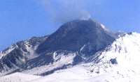
Bezymianny volcano - H. Gaudru 1992
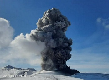
Ebeko eruption on 9th of February 2021 (I.Kotenko - IVS-FE)